Embed Size (px)
Citation preview
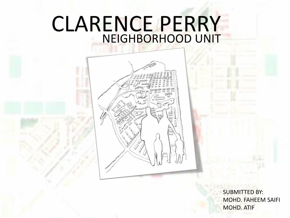
SUBMITTED BY:MOHD. FAHEEM SAIFIMOHD. ATIF
CLARENCE PERRYNEIGHBORHOOD UNIT
1. Men found land which supported them in relative safety and permanent settling
accommodation
2. People with common interests assembled in groups for themselves protection and the
maximum amenities of life.
3. As the city grew in size, some areas within it assumed certain homogenous qualities
which we have identified as neighborhoods.
4. Different standards were established and people who desired and could afford luxuries
moved to outer areas or hills.
5. As the grouping developed it lead from neighborhoods to town.
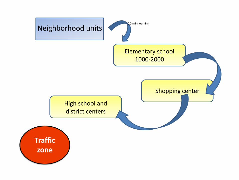
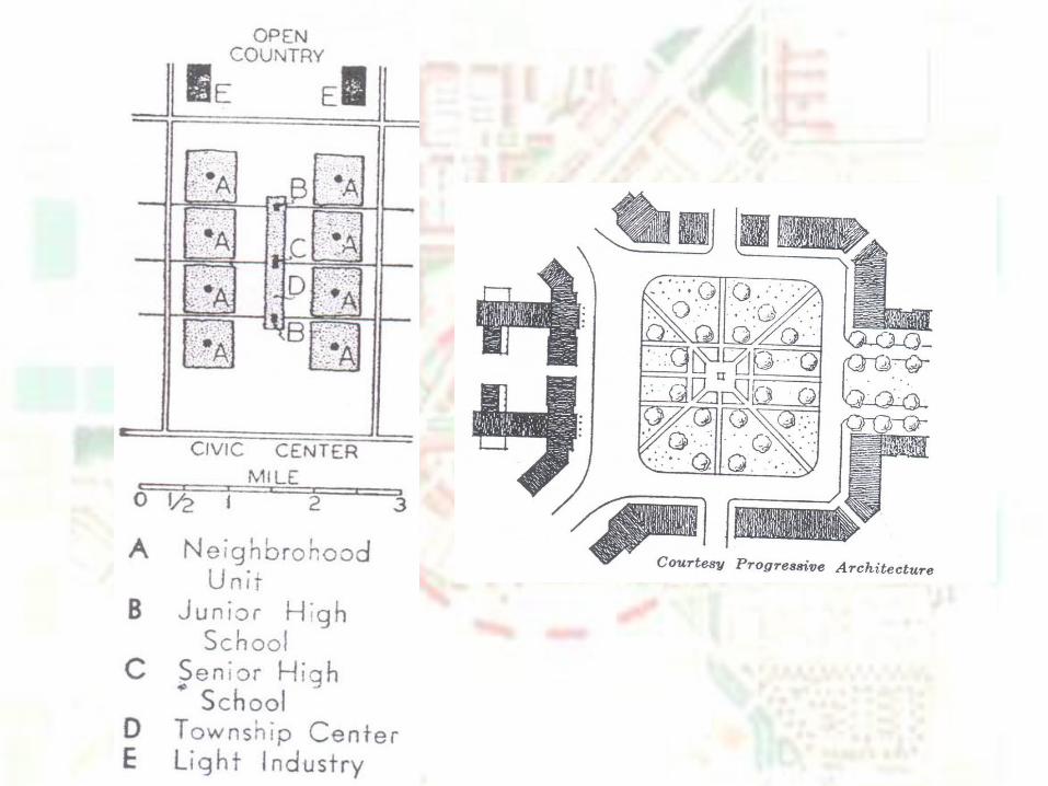
6. The neighborhood unit includes the elementary school, a small shopping district, and
a ground. These facilities are grouped near the center of the unit so that the walking
distance between them and the home does not exceed one-half mile.
EVOLUTION TO TOWN PLANNING
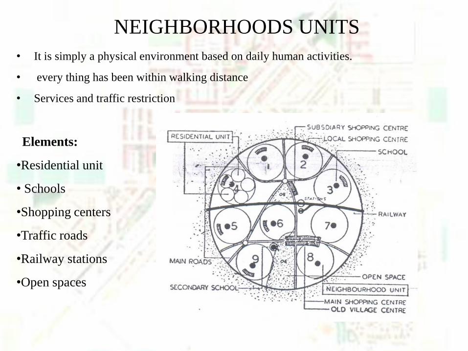
• It is simply a physical environment based on daily human activities.
• every thing has been within walking distance
• Services and traffic restriction
Elements:
•Residential unit
• Schools
•Shopping centers
•Traffic roads
•Railway stations
•Open spaces
NEIGHBORHOODS UNITS
Neighborhood units
Traffic zone
Elementary school1000-2000
Shopping center
High school and district centers
10 min walking
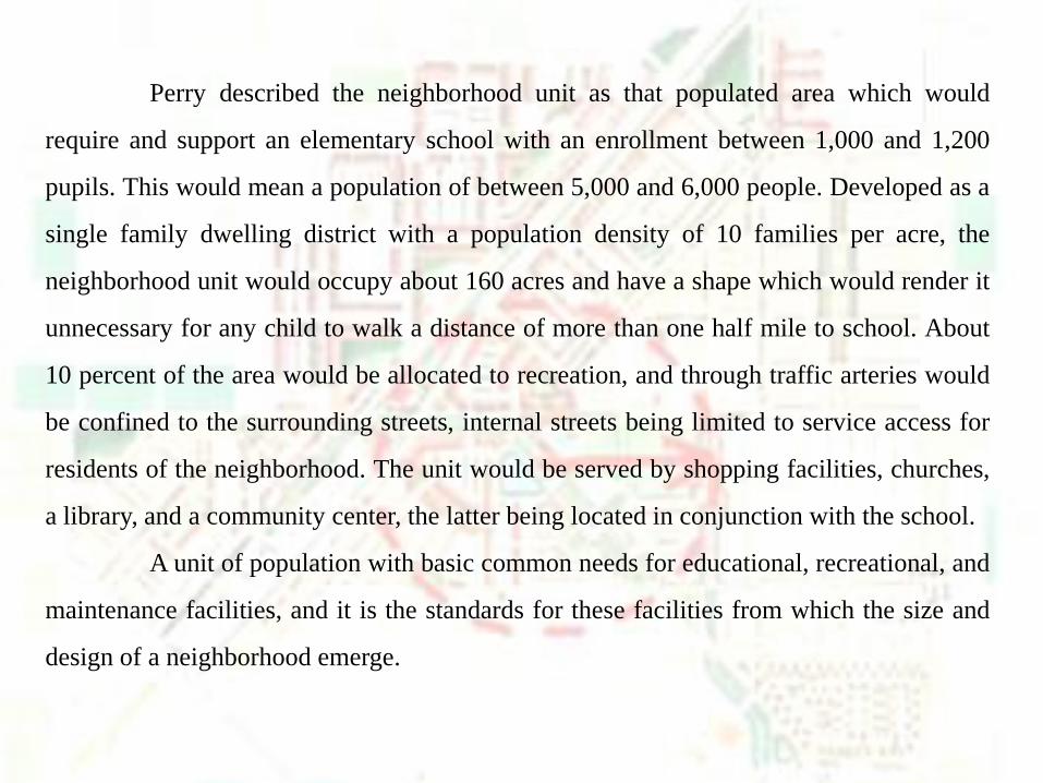
Perry described the neighborhood unit as that populated area which would
require and support an elementary school with an enrollment between 1,000 and 1,200
pupils. This would mean a population of between 5,000 and 6,000 people. Developed as a
single family dwelling district with a population density of 10 families per acre, the
neighborhood unit would occupy about 160 acres and have a shape which would render it
unnecessary for any child to walk a distance of more than one half mile to school. About
10 percent of the area would be allocated to recreation, and through traffic arteries would
be confined to the surrounding streets, internal streets being limited to service access for
residents of the neighborhood. The unit would be served by shopping facilities, churches,
a library, and a community center, the latter being located in conjunction with the school.
A unit of population with basic common needs for educational, recreational, and
maintenance facilities, and it is the standards for these facilities from which the size and
design of a neighborhood emerge.
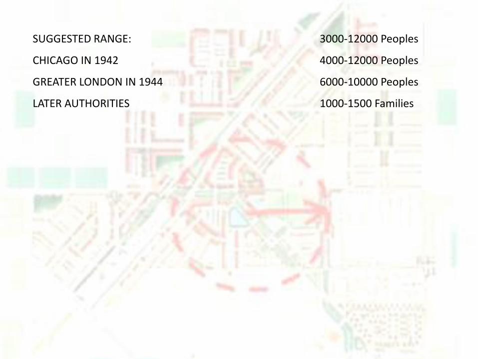
SUGGESTED RANGE: 3000-12000 Peoples
CHICAGO IN 1942 4000-12000 Peoples
GREATER LONDON IN 1944 6000-10000 Peoples
LATER AUTHORITIES 1000-1500 Families
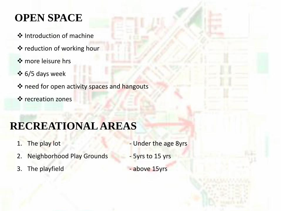
OPEN SPACE
Introduction of machine
reduction of working hour
more leisure hrs
6/5 days week
need for open activity spaces and hangouts
recreation zones
RECREATIONAL AREAS
1. The play lot - Under the age 8yrs
2. Neighborhood Play Grounds - 5yrs to 15 yrs
3. The playfield - above 15yrs
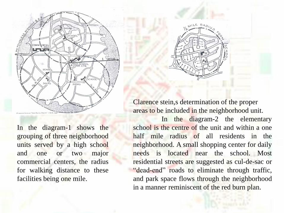
Clarence stein,s determination of the proper
areas to be included in the neighborhood unit.
In the diagram-2 the elementary
school is the centre of the unit and within a one
half mile radius of all residents in the
neighborhood. A small shopping center for daily
needs is located near the school. Most
residential streets are suggested as cul-de-sac or
“dead-end” roads to eliminate through traffic,
and park space flows through the neighborhood
in a manner reminiscent of the red burn plan.
In the diagram-1 shows the
grouping of three neighborhood
units served by a high school
and one or two major
commercial centers, the radius
for walking distance to these
facilities being one mile.
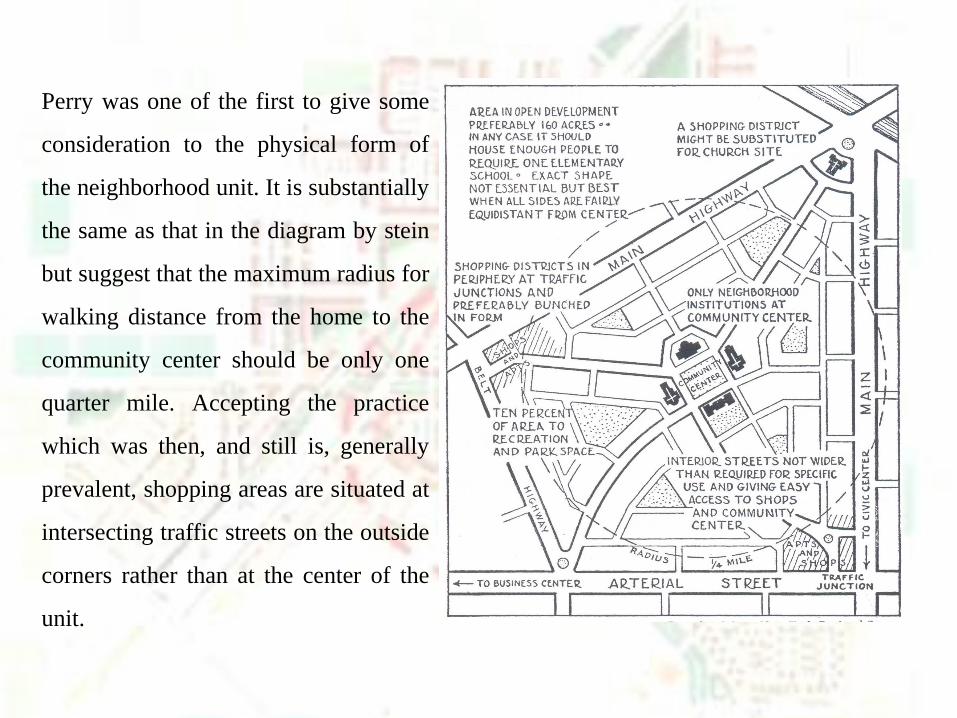
Perry was one of the first to give some
consideration to the physical form of
the neighborhood unit. It is substantially
the same as that in the diagram by stein
but suggest that the maximum radius for
walking distance from the home to the
community center should be only one
quarter mile. Accepting the practice
which was then, and still is, generally
prevalent, shopping areas are situated at
intersecting traffic streets on the outside
corners rather than at the center of the
unit.
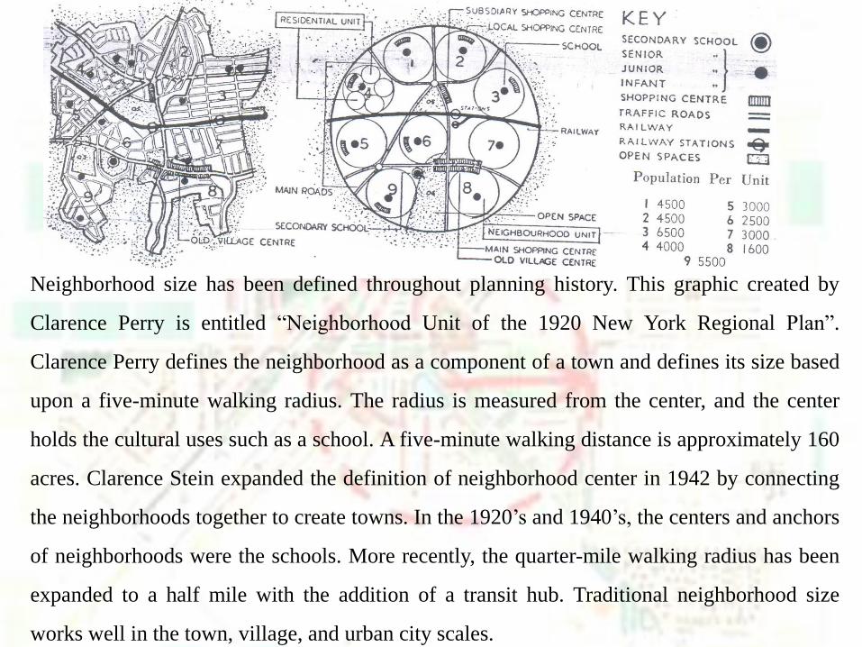
Neighborhood size has been defined throughout planning history. This graphic created by
Clarence Perry is entitled “Neighborhood Unit of the 1920 New York Regional Plan”.
Clarence Perry defines the neighborhood as a component of a town and defines its size based
upon a five-minute walking radius. The radius is measured from the center, and the center
holds the cultural uses such as a school. A five-minute walking distance is approximately 160
acres. Clarence Stein expanded the definition of neighborhood center in 1942 by connecting
the neighborhoods together to create towns. In the 1920’s and 1940’s, the centers and anchors
of neighborhoods were the schools. More recently, the quarter-mile walking radius has been
expanded to a half mile with the addition of a transit hub. Traditional neighborhood size
works well in the town, village, and urban city scales.
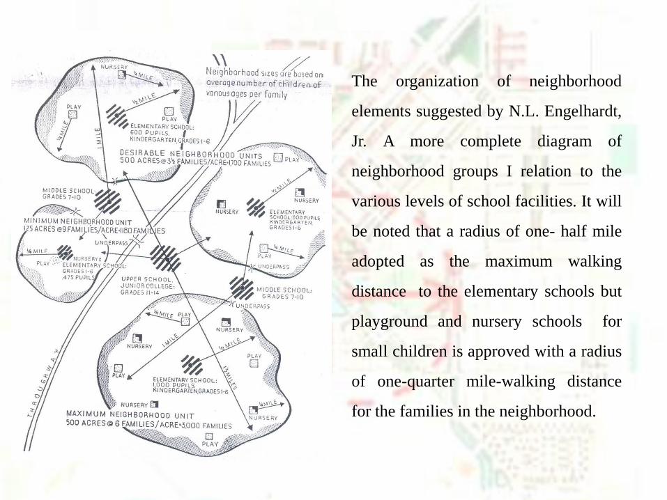
The organization of neighborhood
elements suggested by N.L. Engelhardt,
Jr. A more complete diagram of
neighborhood groups I relation to the
various levels of school facilities. It will
be noted that a radius of one- half mile
adopted as the maximum walking
distance to the elementary schools but
playground and nursery schools for
small children is approved with a radius
of one-quarter mile-walking distance
for the families in the neighborhood.
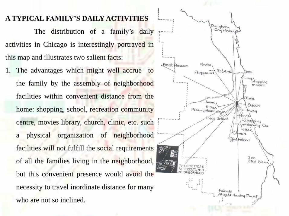
A TYPICAL FAMILY’S DAILY ACTIVITIES
The distribution of a family’s daily
activities in Chicago is interestingly portrayed in
this map and illustrates two salient facts:
1. The advantages which might well accrue to
the family by the assembly of neighborhood
facilities within convenient distance from the
home: shopping, school, recreation community
centre, movies library, church, clinic, etc. such
a physical organization of neighborhood
facilities will not fulfill the social requirements
of all the families living in the neighborhood,
but this convenient presence would avoid the
necessity to travel inordinate distance for many
who are not so inclined.
2. The necessity for adequate transportation- circulation- about the urban framework, to
relieve the time and strain now imposed upon upon the urban dwellers in his daily travel
to and from his work, his friends, and the less frequent, though not less necessary,
cultural facilities a city makes available.
the physical organization of neighborhood units and community groups,
integrated with the transportation system of the city, is intended to accomplish these
objectives and thereby remove the necessity for the range of travel currently imposed
and illustrated in this map.

BIBLIOGRAPHY
• http://images.google.co.in/imgres
• http://www.linkedin.com/pub/dir/clarence/perry
• http://www.tcrpc.org/orientation/02_neighborhood_scale/2_neighborhood_scale_print.pdf
• http://www.spikowski.com/UrbanSlidesFGCU_12-1-2007_Spikowski.pdf
• http://www.tcrpc.org/orientation/2009%20Orientation%20Series/Council%20Series%207-17-
09%20Neighborhood%20Scale.pdf
• The urban pattern by arthur b. Gallion, simon eisner