Embed Size (px)
Citation preview
Sonal Aggarwal Dept. of Urban & Regional Planning
San José State University Spring 2015
Diridon Station Area Pedestrian Street Design Guidelines: Studying the Pedestrian Environment
Around the Station Area
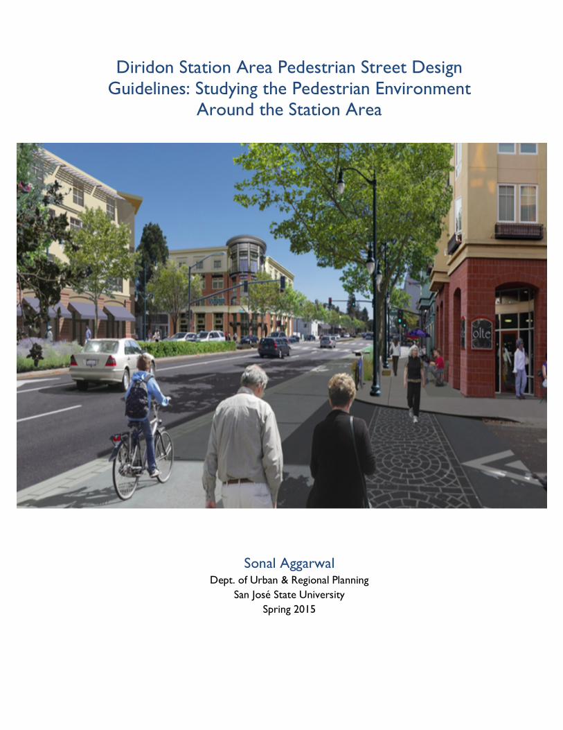
Cover page photo credits: City of San Mateo, Sustainable Cities: Final Plan, 2015. Footer photo credit: Ibid.
This Page was left blank intentionally
Diridon Station Area Pedestrian Street Design Guidelines: Studying the Pedestrian Environment Around the Station Area
A Planning Report
Presented to���
The Faculty of the Department of
Urban and Regional Planning
San José State University
In Partial Fulfillment���
Of the Requirements for the Degree
Master of Urban Planning
By
Sonal Aggarwal
May 2015
This Page was left blank intentionally
ACKNOWLEDGEMENTS
I would like to thank all the people who have helped me in putting this report together. I would specially
like to thank my advisors Prof. Asha Agrawal and Prof. Rick Kos for guiding me in this research.
Also, I would like to offer my regards to my interviewees for providing their valuable inputs and
suggestions for this report.
1. Terry Bottomley, Principal, Bottomley and Associates
2. Ginette Wessel, Professor, San José State University
3. Heidi Sokolowsky, Urban Designer, Urban Field Studio
4. Jessica Zenk, Manager, Transportations Operations, City of San José
5. Jennifer Donlon-Watt, Urban Planner, Alta Planning + Design
Last but not the least, I would like to thank my husband Rahul and my friend Surabhi for keeping my
moral high and being there for me whenever I needed their help.

i
TABLE OF CONTENTS CHAPTER 1- INTRODUCTION OF THE RESEARCH ............................................................... 1
1.1 PURPOSE OF THE REPORT .............................................................................................................................................. 1
1.2 ORGANIZATION OF THE REPORT .............................................................................................................................. 3
CHAPTER 2 - FACTORS THAT ENCOURAGE PEDESTRIAN ACTIVITIES ......................... 4
2.1 PROVISION OF PEDESTRIAN AMENITIES ................................................................................................................... 4
2.2 SAFETY .................................................................................................................................................................................... 6
2.3 ELEMENTS OF VISUAL INTEREST .................................................................................................................................. 9
2.4 TAKE AWAY FOR PROPOSING DESIGN GUIDELINES ........................................................................................ 10
CHAPTER 3 - UNDERSTANDING DIFFERENT STREET ELEMENTS ................................. 12
3.1 DIFFERENT ZONES OF STREETS ................................................................................................................................. 12
3.1.1 Curb Zone .................................................................................................................................................................... 12
3.1.2 Pedestrian Zone .......................................................................................................................................................... 13
3.1.3 Building Zone ............................................................................................................................................................... 13
3.1.4 Building Setback Zone ................................................................................................................................................ 14
3.2 IMPRESSIONS OF OTHER CITIES DESIGN GUIDELINES ...................................................................................... 15
CHAPTER 4 - DIRIDON STATION AREA PLAN ..................................................................... 16
4.1 LAND USE DIAGRAM ....................................................................................................................................................... 17
4.2 STREETS FOCUSING ON VEHICULAR CONNECTIONS .................................................................................... 20
4.3 STREETS FOCUSING ON PEDESTRIAN AND BIKE CONNECTIONS ............................................................. 21
4.3 OTHER TYPE OF STREET CLASSIFICATIONS .......................................................................................................... 22
4.3.1 Proposed New Street Connections ........................................................................................................................ 22
4.3.2 Proposed Improvements in Pedestrian Networks .............................................................................................. 24
4.4 TAKE AWAY FOR PROPOSING DESIGN GUIDELINES ........................................................................................ 25
CHAPTER 5- SITE VISIT ............................................................................................................... 26
5.1 METHODOLOGY ADOPTED FOR CONDUCTING THE SITE VISIT ............................................................... 26
5.2 STREETS GRADING CRITERIA ...................................................................................................................................... 27
5.2.1 Safety .............................................................................................................................................................................. 27
5.2.2 Elements of Visual Interest ........................................................................................................................................ 27
5.2.3 Street Elements ............................................................................................................................................................ 28
5.3 CURRENT CONDITIONS ............................................................................................................................................... 30
5.3.1 Cahill Street ................................................................................................................................................................. 30
5.3.2 Montgomery Street ..................................................................................................................................................... 32
ii
5.3.3 Autumn Street .............................................................................................................................................................. 34
5.3.4 W San Fernando ......................................................................................................................................................... 36
5.3.5 Park Avenue ................................................................................................................................................................. 38
5.3.6 W San Carlos .............................................................................................................................................................. 40
5.3.7 Auzerais Avenue .......................................................................................................................................................... 42
5.3.8 Delmas Ave ................................................................................................................................................................... 44
5.3.9 The Alameda ................................................................................................................................................................. 46
5.3.10 W Santa Clara ............................................................................................................................................................ 48
5.3.11 W Julian Street .......................................................................................................................................................... 50
5.3.12 Bird Avenue ................................................................................................................................................................ 52
5.4 TAKE AWAY FOR PROPOSING DESIGN GUIDELINES ........................................................................................ 54
CHAPTER 6 - DESIGN RECOMMENDATIONS ........................................................................ 55
6.1 CURB ZONE ........................................................................................................................................................................ 55
6.2 PEDESTRIAN ZONE .......................................................................................................................................................... 57
6.3 BUILDING FRONTAGE ZONE ...................................................................................................................................... 58
6.4 SPECIFIC DESIGN RECOMMENDATIONS ................................................................................................................. 59
6.4.1 Cahill Street .................................................................................................................................................................. 59
6.4.2 Montgomery Street ..................................................................................................................................................... 60
6.4.3 Autumn Street .............................................................................................................................................................. 61
6.4.4 W. San Fernando ......................................................................................................................................................... 62
6.4.5 Park Avenue ................................................................................................................................................................. 63
6.4.6 W. San Carlos .............................................................................................................................................................. 64
6.4.7 Auzerais Avenue .......................................................................................................................................................... 65
6.4.8 Delmas Avenue ............................................................................................................................................................ 66
6.4.9 The Alameda ................................................................................................................................................................. 67
6.4.10 Santa Clara .................................................................................................................................................................. 68
6.4.11 W Julian ....................................................................................................................................................................... 69
6.4.12 Bird Avenue ................................................................................................................................................................ 70
6.5 CONCLUSION ................................................................................................................................................................... 71
BIBLIOGRAPHY .............................................................................................................................. 72
APPENDIX A: STREET DESIGN ELEMENTS DISCUSSED IN OTHER GUIDELINES ........ 75
APPENDIX B: LIST OF INTERVIEWEES .................................................................................... 79
APPENDIX C: INTERVIEW QUESTIONS .................................................................................. 80
Interview questions for practicing Planners and Urban Designers ............................................................................ 80
Interview questions for San José's Staff Members ......................................................................................................... 81
iii
LIST OF FIGURES
Figure 1: Diridon Station
Figure 2: Roads under consideration in the study area
Figure 3: Seating areas that are well incorporated with the surroundings
Figure 4: Benches with backrest
Figure 5: Innovatively designed bench
Figure 6: Example of innovative seating area
Figure 7: Ways of installing safety signs
Figure 8: Street with visually interesting elements
Figure 9: Different Zones of Street
Figure 10: Realms of the Street
Figure 11: Diridon Station Area Plan-‐ Final Land Use Plan
Figure 12: Primary Zones in Diridon Station Area Plan
Figure 13: Existing east west Connections-‐Vehicular Emphasis
Figure 14: Existing east west Connections-‐Pedestrian and Bicycle Emphasis
Figure 15: Proposed new Street connections
Figure 16: Walking connections
Figure 17: Types of crosswalks
Figure 18: Map showing key characteristics of each road and observation points
Figure 19: Observation point on Cahill Street
Figure 20: West sidewalk of Cahill Street
Figure 21: East sidewalk of Cahill Street
Figure 22: Observation point on Montgomery Street
Figure 23: West sidewalk of Montgomery Street
Figure 24: East sidewalk of Montgomery Street
Figure 25: Observation point on Autumn Street
Figure 26: West sidewalk of Autumn Street
Figure 27: East sidewalk of Autumn Street
Figure 28: Observation point on W San Fernando Street
Figure 29: Street view of W San Fernando
Figure 30: South sidewalk of W San Fernando Street
Figure 31: Observation point on Park Avenue
Figure 32: South sidewalk of Park Avenue
iv
Figure 33: Street view of Park Avenue
Figure 34: Observation point on W San Carlos
Figure 35: South sidewalk of W San Carlos
Figure 36: Well-‐maintained condition of south sidewalk
Figure 37: Observation point on Auzerais Avenue
Figure 38: Condition of south sidewalk
Figure 39: Broken condition of north sidewalk
Figure 40: Observation point on Delmas Avenue
Figure 41: Street view of Delmas Avenue
Figure 42: Southwestern sidewalk
Figure 43: Observation point on The Alameda
Figure 44: Condition of The Alameda in July 2014, photo taken facing I-‐880
Figure 45: Observation point on W Santa Clara
Figure 46: Current condition of south Sidewalk, photo taken facing Autumn Street
Figure 47: Crosswalk in front of SAP Center
Figure 48: Observation point on Julian Street
Figure 49: Current condition of W Julian Street, photo taken facing The Alameda
Figure 50: Current condition of northwestern sidewalk
Figure 51: Observation point on Bird Avenue
Figure 52: Buildings on the intersection
Figure 53: Current condition of sidewalk
Figure 54: Curb extension on sidewalks
Figure 55: Pinch point on sidewalks
Figure 56: Bus bulbs on sidewalks
Figure 57: Pervious strips on sidewalks
Figure 58: Parklets
Figure 59: Flow-‐through planters
Figure 60: Pervious pavements used on sidewalks
Figure 61: Awnings on buildings
Figure 62: Picture of Overhead supported Canopies
Figure 63: Current condition of Cahill Street
Figure 64: Design solution for Cahill Street provided by author using Google map image
Figure 65: Current condition of Montgomery Street
Figure 66: Design solution for Montgomery Street provided by author
Figure 67: Current condition of Autumn Street
v
Figure 68: Design solution for Autumn Street provided by author
Figure 69: Current condition of W San Fernando Street
Figure 70: Design solution for W San Fernando Street provided by author
Figure 71: Current condition of Park Avenue
Figure 72: Design solution for Park Avenue provided by author
Figure 73: Current condition for W San Carlos
Figure 74: Design solution for W San Carlos Street provided by author
Figure 75: Current condition of Auzerais Avenue
Figure 76: Design solution for Auzerais Avenue provided by author
Figure 77: Current condition of Delmas Street
Figure 78: Design solution for Delmas Street provided by author
Figure 79: Condition of The Alameda in July 2014
Figure 80: Condition of The Alameda in November 2014
Figure 81: Current condition of W Santa Clara Street
Figure 82: Design solution for W Santa Clara Street provided by author
Figure 83: Current condition of W Julian Street
Figure 84: Design solution for W Julian Street provided by author
Figure 85: Current condition of Bird Avenue
Figure 86: Design solution for Bird Avenue provided by author
vi
LIST OF TABLES
Table 1: Summary of Literature Review……………………………………………………………………………………………………………11
Table 2: Grading checklist………………………………………………………………………………………………………………………………..28
Table 3: Observation at point A……………………………………………………………………………………………………………………….31
Table 4: Observation at point B……………………………………………………………………………………………………………………….33
Table 5: Observation at point C……………………………………………………………………………………………………………………….35
Table 6: Observation at point D……………………………………………………………………………………………………………………….37
Table 7: Observation at point E……………………………………………………………………………………………………………………….39
Table 8: Observation at point F……………………………………………………………………………………………………………………….41
Table 9: Observation at point G……………………………………………………………………………………………………………………….43
Table 10: Observation at point H……………………………………………………………………………………………………………………..45
Table 11: Observation at point I………………………………………………………………………………………………………………………47
Table 12: Observation at point J………………………………………………………………………………………………………………………49
Table 13: Observation at point K……………………………………………………………………………………………………………………..51
Table 14: Observation at point L………………………………………………………………………………………………………………………53
1
CHAPTER 1- INTRODUCTION OF THE RESEARCH
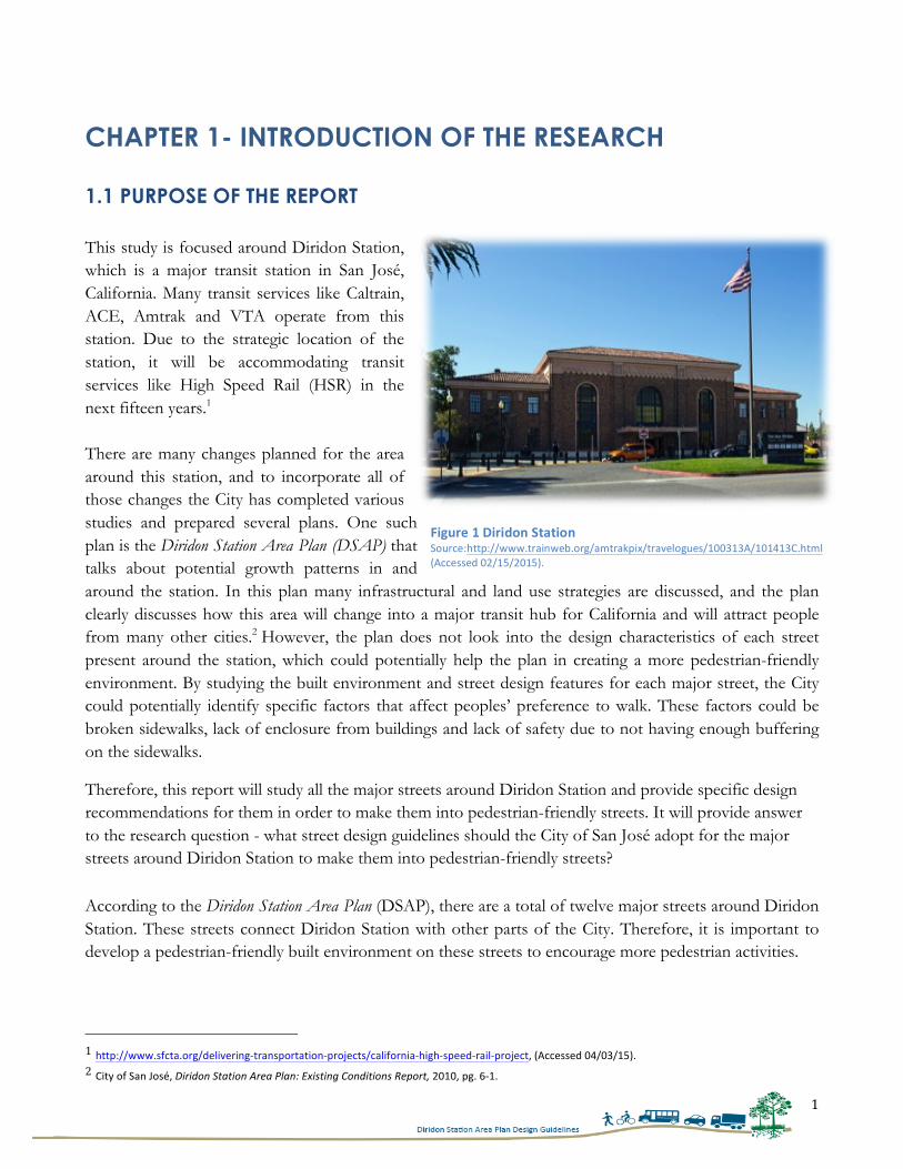
1.1 PURPOSE OF THE REPORT This study is focused around Diridon Station, which is a major transit station in San José, California. Many transit services like Caltrain, ACE, Amtrak and VTA operate from this station. Due to the strategic location of the station, it will be accommodating transit services like High Speed Rail (HSR) in the next fifteen years.1 There are many changes planned for the area around this station, and to incorporate all of those changes the City has completed various studies and prepared several plans. One such plan is the Diridon Station Area Plan (DSAP) that talks about potential growth patterns in and around the station. In this plan many infrastructural and land use strategies are discussed, and the plan clearly discusses how this area will change into a major transit hub for California and will attract people from many other cities.2 However, the plan does not look into the design characteristics of each street present around the station, which could potentially help the plan in creating a more pedestrian-friendly environment. By studying the built environment and street design features for each major street, the City could potentially identify specific factors that affect peoples’ preference to walk. These factors could be broken sidewalks, lack of enclosure from buildings and lack of safety due to not having enough buffering on the sidewalks.
Therefore, this report will study all the major streets around Diridon Station and provide specific design recommendations for them in order to make them into pedestrian-friendly streets. It will provide answer to the research question - what street design guidelines should the City of San José adopt for the major streets around Diridon Station to make them into pedestrian-friendly streets? According to the Diridon Station Area Plan (DSAP), there are a total of twelve major streets around Diridon Station. These streets connect Diridon Station with other parts of the City. Therefore, it is important to develop a pedestrian-friendly built environment on these streets to encourage more pedestrian activities.
1 http://www.sfcta.org/delivering-‐transportation-‐projects/california-‐high-‐speed-‐rail-‐project, (Accessed 04/03/15). 2 City of San José, Diridon Station Area Plan: Existing Conditions Report, 2010, pg. 6-‐1.
Figure 1 Diridon Station Source:http://www.trainweb.org/amtrakpix/travelogues/100313A/101413C.html (Accessed 02/15/2015).
2
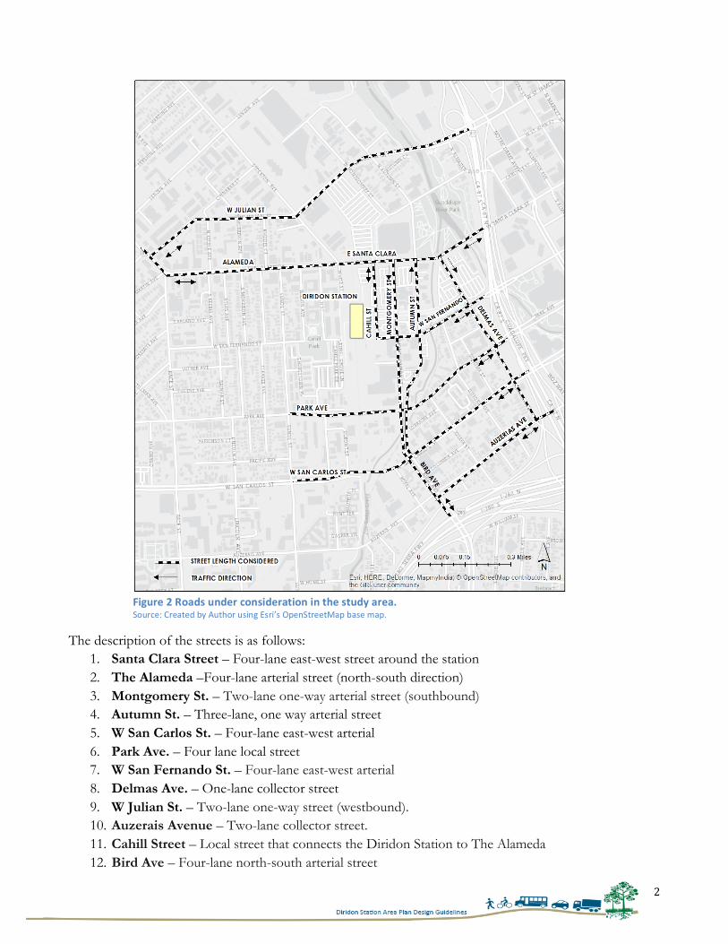
The description of the streets is as follows:
1. Santa Clara Street – Four-lane east-west street around the station 2. The Alameda –Four-lane arterial street (north-south direction) 3. Montgomery St. – Two-lane one-way arterial street (southbound) 4. Autumn St. – Three-lane, one way arterial street 5. W San Carlos St. – Four-lane east-west arterial 6. Park Ave. – Four lane local street 7. W San Fernando St. – Four-lane east-west arterial 8. Delmas Ave. – One-lane collector street 9. W Julian St. – Two-lane one-way street (westbound). 10. Auzerais Avenue – Two-lane collector street. 11. Cahill Street – Local street that connects the Diridon Station to The Alameda 12. Bird Ave – Four-lane north-south arterial street
Figure 2 Roads under consideration in the study area. Source: Created by Author using Esri’s OpenStreetMap base map.
3
In order to analyze these streets, the author adopted the following methodology:
1. Literature Review: In the literature review of this report a total of thirty peer-reviewed and journal articles were reviewed to determine the components that are preferred by pedestrians.
2. Studied and analyzed Diridon Station Area Plans (DSAP): In order to fully understand current and proposed developments around Diridon Station, the author studied various documents that were prepared by the City for Diridon Station: 1. Final Diridon Station Area Plan (DSAP) 2. Diridon Station Area Plan: Existing Conditions Report 3. Diridon Station Area Plan: Final Environmental Impact Report
3. Studied other design guidelines: To fully gain understanding of various street elements, the author studied the Downtown Streetscape Master Plan prepared by the City of San José and seven different Pedestrian Street Design Guidelines prepared by various cities in the United States. A matrix of all the components included in these design guidelines was prepared, which is attached in Appendix A of this report.
4. Interviews: In order to better understand pedestrian planning, the author conducted five interviews with planners and designers who are currently working on various pedestrian related projects. The findings from these interviews are incorporated in various chapters of this report.
5. Field Assessment: To record existing conditions of the streets, the author conducted a walking
tour of all the twelve streets and recorded the observations using a checklist. These observations are discussed in chapter 5 of this report.
1.2 ORGANIZATION OF THE REPORT Chapter 1 introduces the research and introduces the study area. Chapter 2 analyzes the elements that are valued by pedestrians and evaluates the previous literature on three themes: provision of pedestrian amenities, safety, and elements of visual interest. Moving further, Chapter 3 discusses different zones of the streets and builds the background for understanding different street elements in detail. Chapter 4 talks about the developments that are proposed in the DSAP and provides the City’s vision for this area. Chapter 5 describes the existing conditions of the roads and discusses the site visit conducted by the author. Chapters 6 provide design recommendations and conclude the research.
4
CHAPTER 2 – FACTORS THAT ENCOURAGE PEDESTRIAN ACTIVITIES This chapter contains the literature review conducted by the author to identify the factors that encourage people to walk on streets. In order to do so, the three major objectives set down for literature review are to understand people’s perception towards walking, factors that improve physical activity amongst residents and the relationship between the built environment and active walking behavior in neighborhoods. A synthesis of findings will provide a basis for developing an analysis framework for the case study and recommendations in later chapters of this report.
A number of theories and research studies that relate to and address the mentioned factors are reviewed to identify the key factors that determine people’s preference for walking. A critical review of literature points towards three major factors that determine a typical pedestrian’s preference for walking: (i) Pedestrian amenities; (ii) Safety, and; (iii) Presence of visually aesthetic elements. Each of these factors will be discussed in detail and supported by the theories developed through previously conducted research work.
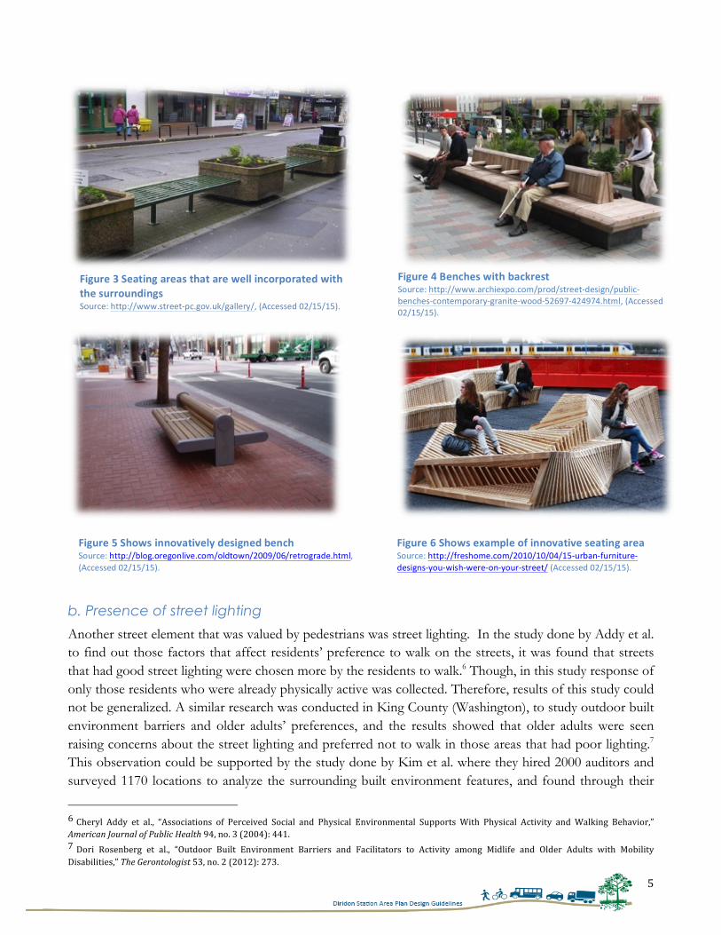
2.1 PROVISION OF PEDESTRIAN AMENITIES Literature that focuses on the provision of pedestrian amenities reveals various amenities that are valued by pedestrians (such as trash cans, street signage, etc.), but two elements that emerge as the most highly valued pedestrian amenities are: (i) Presence of benches, and; (ii) Street lighting. In all of the research studies that were selected for this literature review, it was found that researchers specifically focused on both of these elements. Therefore these elements have been included to understand peoples’ preferences and perceptions.
a. Presence of benches
In one of the studies conducted by Cauwenberg et al. where they showed several photographs and asked people about their first and second preferences, it was found that presence of benches was highly noticed by the participants, and all photographs selected by the participants had benches in them.3 Another study in Bogota (Columbia), conducted to study the relationship of built environment and pedestrian activities around BRT stations, researchers found significance between the presence of benches and evidence of more walking on the streets.4 This conclusion is further strengthened by a study conducted by Rosenberg et al. in King County (Washington) where they interviewed thirty-five older adults and found through the analysis most participants preferred having benches to rest on while walking on the streets.5 However, this study was conducted in a hilly terrain, due to which benches could have been of more importance to pedestrians. Therefore results of this study could not be generalized. Figure 3, 4, 5 and 6 shows examples of innovative benches that are valued by pedestrians in a walking environment.
3 Jelle Cauwenberg et al., “Physical Environmental Factors that Invite Older Adults to Walk for Transportation,” Journal of Environmental Phycology 38, no.0 (2014): 98. 4 Daniel Rodriguez, Elizabeth M. Brisson, and Niclolas Estupian, “The Relationship Between Segment-‐Level Built Environment Attributes and Pedestrian Activity Around Bogota’s BRTS Stations,” Transportation Research Part D 14, no.7 (2009): 477. 5 Dori Rosenberg et al., “Outdoor Built Environment Barriers and Facilitators to Activity among Midlife and Older Adults with Mobility Disabilities,” The Gerontologist 53, no. 2 (2012): 276.
5
b. Presence of street lighting
Another street element that was valued by pedestrians was street lighting. In the study done by Addy et al. to find out those factors that affect residents’ preference to walk on the streets, it was found that streets that had good street lighting were chosen more by the residents to walk.6 Though, in this study response of only those residents who were already physically active was collected. Therefore, results of this study could not be generalized. A similar research was conducted in King County (Washington), to study outdoor built environment barriers and older adults’ preferences, and the results showed that older adults were seen raising concerns about the street lighting and preferred not to walk in those areas that had poor lighting.7 This observation could be supported by the study done by Kim et al. where they hired 2000 auditors and surveyed 1170 locations to analyze the surrounding built environment features, and found through their
6 Cheryl Addy et al., “Associations of Perceived Social and Physical Environmental Supports With Physical Activity and Walking Behavior,” American Journal of Public Health 94, no. 3 (2004): 441. 7 Dori Rosenberg et al., “Outdoor Built Environment Barriers and Facilitators to Activity among Midlife and Older Adults with Mobility Disabilities,” The Gerontologist 53, no. 2 (2012): 273.
Figure 4 Benches with backrest Source: http://www.archiexpo.com/prod/street-‐design/public-‐benches-‐contemporary-‐granite-‐wood-‐52697-‐424974.html, (Accessed 02/15/15).
Figure 5 Shows innovatively designed bench Source: http://blog.oregonlive.com/oldtown/2009/06/retrograde.html, (Accessed 02/15/15).
Figure 6 Shows example of innovative seating area Source: http://freshome.com/2010/10/04/15-‐urban-‐furniture-‐designs-‐you-‐wish-‐were-‐on-‐your-‐street/ (Accessed 02/15/15).
Figure 3 Seating areas that are well incorporated with the surroundings Source: http://www.street-‐pc.gov.uk/gallery/, (Accessed 02/15/15).
6
study that satisfaction of recreational walkers had a significant and positive impact determined by the presence of street lamps on the streets.8
2.2 SAFETY Many researchers have looked into factors that influence people’s decision to walk9 and found that people value safe walkable environments. When people are apprehensive about their environment or are fearful of vehicular traffic, they choose to walk less on streets. Amongst various factors of safety, people are concerned about safety from vehicular traffic, and safety from crime. These safeties are important and therefore warrant further discussion in order to understand people’s preference.
a. Safety from Vehicular traffic
Several researchers have looked into factors that influence people’s route choice, and found that safety is the primary concern for pedestrians in choosing a route.10 In the auto-centric cities, pedestrians suffer many traffic injuries.11 It is because of this reason that they show less preference to walk in heavy traffic areas. This can be further understood from the study conducted by Dandan et al. where they asked pedestrians about their perceptions regarding walking on streets and found that 75 percent of pedestrians felt that traffic had influenced their decision to walk.12 Similar observations were made by two different studies, the first of which examined the walking patterns of the elder population in Bogota (Columbia), and another one explored pedestrians’ perception of walkability with respect to built environment in Cali (Columbia). Both of these studies concluded that
8 Saehoon Kim, Sungjin Park, and Seung Lee, “Meso-‐or-‐Micro–Scale? Environmental Factors Influencing Pedestrian Satisfaction,” Transportation Research Part D 30, (2014): 16. 9 C. E. Kelly et al., “A Comparison of Three Methods for Accessing the Walkability of the Pedestrian Environment,” Journal of Transport Geography 19, no. 41 (2011): 1500-‐1508; Yvonne Michael, Mandy K. Green, and Stephanie A. Farquhar, “Neighborhood Design and Active Aging,” Health & Place 12, no.0 (2006): 734-‐740; Kelli Cain et al., “Contribution of Streetscape audits to Explanation of Physical Activity in Four Age Groups Based on the Microscale Audits of Pedestrian Streetscapes (MAPS),” Social Science and Medicine 116 (2014): 82-‐92; Luis Gomez et al., “ Built Environment Attributes and Walking Patterns Among the Elderly Population in Bogotá,” American Journal of Preventive Medicine 38, no. 6 (2010): 592-‐599; Noor Bahari, Ahmad Kamil Arshad, and Zahryllaili Yahya, “Assessing the Pedestrians’ Perception of the Sidewalk Facilities Based on Pedestrian Travel Purpose,” IEEE 9th International Colloquium on Signal Processing and its Applications, (2013): 27-‐32. 10 Noor Bahari, Ahmad Kamil Arshad, and Zahryllaili Yahya, “Assessing the Pedestrians’ Perception of the Sidewalk Facilities Based on Pedestrian Travel Purpose,” IEEE 9th International Colloquium on Signal Processing and its Applications, (2013): 27-‐32; Yvonne Michael, Mandy K. Green, and Stephanie A. Farquhar, “Neighborhood Design and Active Aging,” Health & Place 12, no.0 (2006): 734-‐740; C. E. Kelly et al., “A Comparison of Three Methods for Accessing the Walkability of the Pedestrian Environment,” Journal of Transport Geography 19, no. 41 (2011): 1500-‐1508. 11 Andres Villaveces et al., “Pedestrians’ Perceptions of Walkability and Safety in Relation to the Built Environment in Cali, Columbia,” Injury Prevention 18, (2012): 291. 12 Tan Dandan et al., “Research on Methods of Accessing Pedestrian Level of Service for Sidewalks,” Journal of Transportation Systems Engineering and Information Technology 7, no.5 (2007): 76.
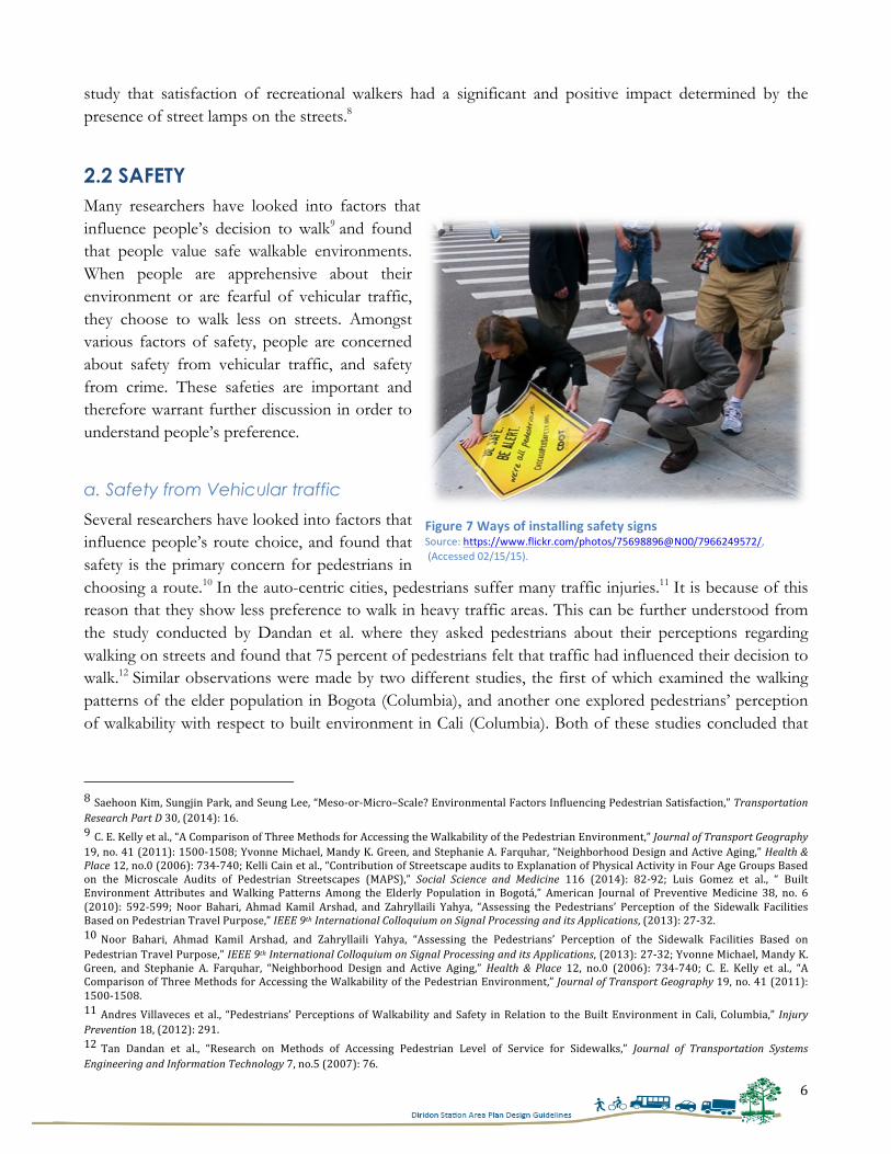
Figure 7 Ways of installing safety signs Source: https://www.flickr.com/photos/75698896@N00/7966249572/, (Accessed 02/15/15).
7
pedestrians were afraid to walk in heavy traffic zones.13 In Bogota, 1966 adults were surveyed to find their perceptions about road environment and it was found that 64 percent responded that perception of traffic on streets had hindered their preference to walk and they chose not to walk in high traffic areas.14 Similarly, in Cali 13.3 percent pedestrians responded that they are afraid to walk, because of the traffic injuries they have had in the last five years.15 However, both of these research studies were conducted in Latin American cities, where traffic volumes and densities substantially differ from North America. Hence, these results could not be generalized for North American cities. A set of parallel studies examined similar aspects and arrived to contrasting conclusions.16 These studies revealed that people were not primarily concerned about the safety issues but rather preferred routes that were short and easily accessible. Agrawal et al. studied the distances that people would walk to access transit stations and found that safety was the second most important concern for pedestrians. This conclusion is further supported by the study done by Mehta where he found safety to be fourth most important concern for pedestrians, through a survey rating.17 The reason why these research studies have come to very different conclusion than the research study of Bogota and Cali could be understood from their study area. Both of these studies were conducted around transit stations where traffic-calming techniques are already well executed and designed and therefore, pedestrians did not find traffic safety issues as their major concern. This leads us to the conclusion that in spite of heavy traffic on roads pedestrians could be encouraged to walk using proper design techniques. To substantiate, a study conducted by Kang et al. measured Level of Service of sidewalks and found that people preferred walking on those streets that had proper segregation between vehicular and non-vehicular paths.18 Kaparias et al. made similar observations about buffer zones and found that people’s perceptions about safety improved as segregation increased.19 However, study done by Hammond and Musselwhite provided contradictory results, and they determined that people could even be satisfied with the shared spaces.20 In this study they interviewed residents of the same community after the street upgrades and found that after necessary design upgrades residents were found satisfied using the same space.21
13 Luis Gomez et al., “Built Environment Attributes and Walking Patterns Among the Elderly Population in Bogotá,” American Journal of Preventive Medicine 38, no. 6 (2010): 592-‐599; Andres Villaveces et al., “Pedestrians’ Perceptions of Walkability and Safety in Relation to the Built Environment in Cali, Columbia,” Injury Prevention 18, (2012): 291-‐297. 14 Luis Gomez et al., “Built Environment Attributes and Walking Patterns Among the Elderly Population in Bogotá,” American Journal of Preventive Medicine 38, no. 6 (2010): 596. 15 Andres Villaveces et al., “Pedestrians’ Perceptions of Walkability and Safety in Relation to the Built Environment in Cali, Columbia,” Injury Prevention 18, (2012): 292. 16 Vikas Mehta, “Walkable Streets: Pedestrians Behavior, Perceptions and Attitudes,” Journal of Urbanism: International Research on Placemaking and Urban Sustainability, 1:3, (2008): 217-‐245; Asha Agrawal, Marc Schlossberg, and Katja Irvin, “How Far, by Which Route and Why? A Spatial Analysis of Pedestrian Preference,” Journal of Urban Design 13, no. 1 (2008): 81-‐98. 17 Vikas Mehta, “Walkable Streets: Pedestrians Behavior, Perceptions and Attitudes,” Journal of Urbanism: International Research on Placemaking and Urban Sustainability, 1:3, (2008): 241. 18 Lei Kang, Yingge Xiong, and Fred L. Mannering, “Statistical Analysis of Pedestrian Perceptions of Sidewalk Level of Service in the Presence of Bicycles,” Transportation Research Part A 53, no.0 (2013): 19. 19 Ionnis Kaparias et al., “Analysing the Perceptions of Pedestrians and Drivers to Shared Space,” Transportation Research Part F 15, no.3 (2012): 309. 20 Victoria Hammond, and Charles Musselwhite, “The Attitudes, Perceptions, and Concerns of Pedestrians and Vulnerable Road Users to Shared Space: A Case Study from the UK,” Journal of Urban Design 18, no. 1 (2003): 79. 21 Ibid, pg. 94.
8
This shows that people’s perception about traffic safety could be improved by adopting proper urban design solutions such as wide sidewalks and vegetation buffers. This assumption is supported by the study done by Michael et al. where all these researchers found that vegetation buffers between sidewalk and road enhanced safety perceptions of the pedestrians.22
b. Safety from crime
Safety from crime is another major concern for pedestrians before choosing a route. In a study done by Brown et al., where they analyzed two routes on the basis of their walkability, they found that higher walkable routes received fewer comments on crime issues in the survey. 23 Safety from crime was considered important in another study conducted by Arrifin and Zahari where they conducted 126 surveys in three Malaysian neighborhoods and found that second highest rating was given to crime safety.24 Additionally, 54.8 percent of people reported that they would start walking more if crime concerns are reduced.25 This finding was further strengthened through a qualitative research done by Alfanzo, where he found safety to be third most important factor for streets, after feasibility and accessibility.26 Another study analyzed the relation of street lighting and perception of crime issues and found that people avoided those roads that had poor lighting conditions, being skeptical about their safety issue.27 Two other studies looked into factors that encourage older adults to walk, and found that older adults preferred to walk on those streets where they could see other people on the sidewalks,28 or where they could found surveillance cameras.29 This could be because of their limited walking abilities. As older adults walk slowly, they prefer to walk in those areas where they could find help easily. 30 Crime issues could also be perceived because of the physical conditions of the surroundings. The study conducted by Alfanzo found that streets that were poorly maintained, or had graffiti issues, were perceived as unsafe.31 This study is supported by the findings of Alfanzo et al., where they studied eleven California cities on the basis of their design features, and found that areas that had design elements such as windows facing the roads, more street lighting, fewer abandoned buildings and fewer vacant lots, had more adults
22 Yvonne Michael, Mandy K. Green, and Stephanie A. Farquhar, “Neighborhood Design and Active Aging,” Health & Place 12, no.0 (2006): 734-‐740; Tan Dandan et al., “Research on Methods of Accessing Pedestrian Level of Service for Sidewalks,” Journal of Transportation Systems Engineering and Information Technology 7, no.5 (2007): 74-‐79. 23 Barbara Brown et al., “Walkable Route Perceptions and Physical Features: Converging Evidence for En Route Walking Experiences,” Environment and Behavior 39, no.1 (2006): 36. 24 Raja Ariffin, and Rustam khairi Zahari, “Perceptions of the Urban Walking Environments,” Procedia-‐ Social and Behavioral Sciences 105, no.0 (2013): 593. 25 Ibid, pg. 593. 26 Mariela Alfonzo, “To Walk or Not to Walk? The Hierarchy of Walking Needs,” Environment and Behavior 37, no.6 (2005): 825. 27 Antal Haans, and Yvonne A.W. de Kort, “Light Distribution in Dynamic Street Lighting: Two Experimental Studies on its Effects on Perceived Safety, Prospect, Concealment and Escape,” Journal of Environmental Psychology 32, (2012): 346. 28 Jelle Cauwenberg et al., “Relationships Between the Perceived Neighborhood Social Environment and Walking for Transportation Among Older Adults,” Social Science and Medicine 104, no.0 (2014): 28. 29 Jelle Cauwenberg et al., “Physical Environmental Factors that Invite Older Adults to Walk for Transportation,” Journal of Environmental Phycology 38, (2014): 100. 30 Jelle Cauwenberg et al., “Relationships Between the Perceived Neighborhood Social Environment and Walking for Transportation Among Older Adults,” Social Science and Medicine 104, no.0 (2014): 26. 31 Mariela Alfonzo, “To Walk or Not to Walk? The Hierarchy of Walking Needs,” Environment and Behavior 37, no.6 (2005): 828.
9
walking on them than those where these were absent.32 To strengthen this observation, Ewing et al. used experts rating on forty-eight video clips, and found that the use of glass windows on ground floor could increase transparency, and thereby reduce safety concerns.33 This shows that presence of blank walls, fewer windows, and less streetlight could raise crime safety issues on the roads, and therefore these features should be avoided. Streets should be designed with more glass windows and openings to provide safer walking environment.
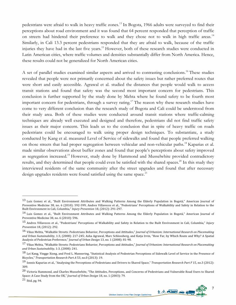
2.3 ELEMENTS OF VISUAL INTEREST Pedestrians move at slow speeds as compared to automobiles, and hence they require more complexity in terms of scenes and elements to hold their interest.34 As stated by Ewing et al. streets that are high in complexity and have presence of many elements such as building details, signs, different surfaces, changing light patterns, and movements are considered interesting.35 This belief is supported by Alfanzo, who also studied elements that provide pleasure while walking, and found that pleasurable environment include street trees, mixed uses, attractive and interesting architecture, historic and unique buildings, among others.36 Figure 8 shows an example of such a street.
Ewing et al. also states “an interesting network will have physiological effect of making network ‘shorter’, by the virtue that the trips is ‘divided naturally into manageable stages’.”37 This assumption could be supported by a study done in Rio de Janerio were participants reported that their travel distances seemed reduced to them due to the presence of trees, landscaping, and shrubs along their route.38
A few other studies support this fact and state that pedestrians enjoy walking on attractive-looking routes.39 Three studies came up with similar findings and claimed that the pedestrians preferred routes that
32 Mariela Alfonzo et al., “The Relationship of Neighborhood Built Environment Features and Adult Parents’ Walking,” Journal of Urban Design 13, no. 1 (2008): 44. 33 Reid Ewing et al., “Measuring the Unmeasurable: Urban Design Qualities Related to Walkability: Urban Design Qualities Related to Walkability,” Journal of Urban Design 14:1, (2009): 78. 34 Reid Ewing et al., “Measuring the Unmeasurable: Urban Design Qualities Related to Walkability: Urban Design Qualities Related to Walkability,” Journal of Urban Design 14:1, (2009): 80 35 Ibid, pg. 80. 36 Mariela Alfonzo, “To Walk or Not to Walk? The Hierarchy of Walking Needs,” Environment and Behavior 37, no.6 (2005): 829. 37 Reid Ewing et al., “Measuring the Unmeasurable: Urban Design Qualities Related to Walkability: Urban Design Qualities Related to Walkability,” Journal of Urban Design 14:1, (2009): 80. 38 Fernanda Monteiro et al., “A Proposal of Indicators for Evaluation of the Urban Pedestrians and Cyclists in Access to Mass Transit Station,” Procedia-‐ Social and Behavioral Sciences 54, no.0 (2012): 640. 39 Barbara Brown et al., “Walkable Route Perceptions and Physical Features: Converging Evidence for En Route Walking Experiences,” Environment and Behavior 39, no.1 (2006): 34-‐61; Dori Rosenberg et al., “Outdoor Built Environment Barriers and Facilitators to Activity among Midlife and Older Adults with Mobility Disabilities,” The Gerontologist 53, no. 2 (2012): 268-‐279; Yvonne Michael, Mandy K. Green, and Stephanie A. Farquhar, “Neighborhood Design and Active Aging,” Health & Place 12, no.0 (2006): 734-‐740.
Figure 8 Street with visually interesting elements Source: http://nyexp-‐elabarbera.blogspot.com/2011/06/battery-‐park-‐and-‐chelsea-‐thursday-‐june.html, (Accessed 02/15/15).
10
had trees, shrubs, natural features, historic elements, etc.40 Hosseini et al. looked into before-and-after street improvement perceptions and found that people who perceived their neighborhood to be beautiful were more likely to walk for recreational purposes.41
In order to create an attractive walking environment, having proper proportions of street elements is essential. Two other studies conducted in-depth analysis of attractive walking environments by showing photographs to participants and found that an ideal proportion of greenery in any photo frame should be at least 40 percent, in order to be considered as attractive. Additionally, the percentage of sky in any photo frame should be anywhere in between 10 to 20 percent.42
Therefore, from the above discussion it can be ascertained that pedestrians enjoy walking on those streets where they could see multiple interesting elements together. Street trees, shrubs, and natural features are a few key elements that are valued by pedestrians, amongst many others. These elements help pedestrians to feel that their route is short and not boring. Therefore, planners should pay careful attention while providing these elements on the sidewalks. Moreover, they should carefully design the surroundings to build an attractive-looking walkable environment.
2.4 TAKE AWAY FOR PROPOSING DESIGN GUIDELINES This literature review has come to a general agreement that pedestrians value various aspects of the built environment, but they remain particularly concerned about on-street safety and pedestrian amenities. Unlike safety, the third requirement, elements of visual interest are also considered desirable, but they do not restrict pedestrians from using the streets. Therefore, if provided, they only enhance pedestrian’s experience. Based on this literature review it can be concluded that the major elements that are useful in creating a safe walking environment for pedestrians are: (i) Presence of trees between sidewalk and street; (ii) Presence of buffered sidewalks using parking, bike lane or by providing bike stations, and; (iii) Presence of marked crosswalks. Having more window openings on the street could help in improving safety from crime, and having more shrubs and plants could help in retaining pedestrians’ interest. It is to be noted here that this literature review was only able to find relevant articles on street lighting and benches. Therefore, more research could be conducted for other street elements that are considered desirable by pedestrians.
40 Sayed Bagher Hosseini, Saeid Norouzian Maleki, and Amirreza Karimi Azari, “The Influences of Access Improvements in Pedestrian Street Use,” Procedia-‐ Social Behavioral Sciences 35, (2012): 645-‐651; Barbara Brown et al., “Walkable Route Perceptions and Physical Features: Converging Evidence for En Route Walking Experiences,” Environment and Behavior 39, no.1 (2006): 34-‐61; Jelle Cauwenberg et al., “Physical Environmental Factors that Invite Older Adults to Walk for Transportation,” Journal of Environmental Phycology 38, no.0 (2014): 94-‐103. 41 Sayed Bagher Hosseini, Saeid Norouzian Maleki, and Amirreza Karimi Azari, “The Influences of Access Improvements in Pedestrian Street Use,” Procedia-‐ Social Behavioral Sciences 35, (2012): 648. 42 Byung Lee et al., “Design Criteria for an Urban Sidewalk Landscape Considering Emotional Perception,” Journal of Urban Planning and Development 135, no.4 (2009): 139; Weijie Wang, Byungjoo Lee, and Moon Namgung, “Extracting Features of Sidewalk Space Using the Rough Sets Approach,” Environment and Planning B: Planning and Design 35, (2008): 933.
11
Table 1 Summary of the Literature Review
Pedestrian Scale Elements
Pedestrians prefer streets that are well illuminated during the night hours, compared to those that are dark Provision of benches should be encouraged on the streets
Safety Safety from vehicular traffic could be improved by: • Buffering the sidewalk using parking, bike lane or by providing bike
stations • Presence of marked crosswalks improves the vehicular safety • Presence of trees between sidewalk and street improves pedestrian safety
Safety from crime could be improved by:
• Maintaining the sidewalks and keeping them in a good condition, as condition of sidewalks are associated with the characteristics of the neighborhood
• Designing buildings that have windows facing the roads
Elements of visual interest
Building elements such as awnings, roadside plantings, use of innovative building materials on sidewalks creates visual interest for pedestrians and encourages them to walk.
According to this literature review, the above elements have a positive impact on pedestrians and therefore these design elements should be carefully considered while designing streets for pedestrians around Diridon Station. This chapter helped in identifying the street elements that are preferred by pedestrians and the following chapter will provide details of each street zone and their elements.
12
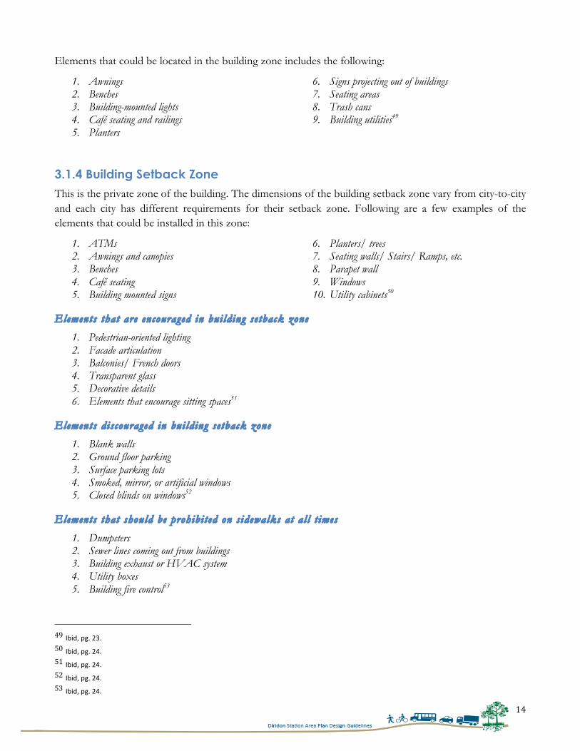
CHAPTER 3 - UNDERSTANDING DIFFERENT STREET ELEMENTS This chapter will establish general understanding of the different street zones. It will discuss pedestrian zone s idewalk in detail. It will also discuss the street zones that are considered by other cities while writing their design guidelines.
3.1 DIFFERENT ZONES OF STREETS There are mainly two zones on streets – vehicular and pedestrian. In certain cases, streets only possess vehicular zone and do not contain the other. Since this study is focused on pedestrians, it will be only discussing pedestrian zone sidewalk in detail. Sidewalks are an important part of streets. They not only provide space for pedestrians to travel but also space for installing city amenities, such as street lamps, benches, bike racks etc. The use of sidewalks changes according to their land use type. In residential neighborhoods sidewalks could be used to enhance pubic health, whereas in commercial areas they could be used to provide access to shops and developments.43 There are primarily three zones in sidewalks: Curb Zone, Pedestrian Zone and Building Zone. To understand these zones and their elements, it is necessary to study these in detail. The Downtown Streetscape Master Plan prepared by the City of San José in 2003 has explained these zones and their characteristics in detail. The City should develop similar guidelines for the Diridon Station Area Plan to create a stronger linkage between the DSAP and the adjacent downtown area. Doing this could help the City in creating a uniform vision for this area and adopt the best practices from the existing documents of the City. To achieve this, the following discussion will provide a general understanding of the zones and highlight some of the elements that were recommended in the Downtown Streetscape Master Plan for these zones.
43 http://nacto.org/usdg/street-‐design-‐elements/sidewalks/, (Accessed 04/16/15).
Figure 9 Different zones of Streets, Source: Urban Street Design Guidelines, NATCO.
Building Zone Pedestrian Zone Curb Zone
Curb Zone Extension
Building setback Zone
13
3.1.1 Curb Zone It is the zone that is next to the road. It is the area where most street furniture and utility boxes are installed. Different curb zones may contain different elements depending upon their location. For a street located in the downtown area, curb zone may consist of many amenities or landscaping, whereas for other areas they could be left only paved without any extra treatments.44 Following is the list of elements that lie in the curb zone:
1. Benches 2. Bike racks 3. Café seating directional signage 4. Bus shelters 5. Fire hydrants 6. Planters 7. Regulatory signage 8. Street lights 9. Trash Receptacles/Recycle containers 10. Trees well grates and guards 11. Traffic signals 12. Historic markers
13. Kiosks 14. News racks 15. Parking meters 16. Pay Phones 17. Pedestrian lighting 18. Postal boxes 19. Traffic signal poles 20. Street trees 21. Tree lawn 22. Utility Boxes/Vaults 23. Wayfinding signage 45
According to Downtown Streetscape Master Plan streets in downtown should be four feet wide from back to curb, residential streets should be five feet from back to curb, and for urban streets should be at least five feet wide for placing the street furniture.46
3.1.2 Pedestrian Zone It is the zone of sidewalk that is specifically dedicated for pedestrian movement and it should be kept clear at all times for uninterrupted pedestrian circulation. This zone should always be well maintained for encouraging more pedestrian activities. It should also be free from tree grates, light poles and other elements.47
Regardless of the location of sidewalks, this zone should be always at least five feet wide to allow comfortable pedestrian movement. It should be around eight feet wide for Paseos (plazas meant for walking).48
3.1.3 Building Zone It is the zone that is next to the pedestrian zone. Any pedestrian element that was not accommodated in the curb zone could be placed in this zone. Streets that have narrow sidewalks often lack this zone.
44 City of San José, San José Downtown Streetscape Master Plan, 2003, pg. 21. 45 Ibid, pg. 21. 46 Ibid, pg. 21. 47 Ibid, pg. 21. 48 Ibid, pg. 22.
14
Elements that could be located in the building zone includes the following:
1. Awnings 2. Benches 3. Building-mounted lights 4. Café seating and railings 5. Planters
6. Signs projecting out of buildings 7. Seating areas 8. Trash cans 9. Building utilities49
3.1.4 Building Setback Zone This is the private zone of the building. The dimensions of the building setback zone vary from city-to-city and each city has different requirements for their setback zone. Following are a few examples of the elements that could be installed in this zone:
1. ATMs 2. Awnings and canopies 3. Benches 4. Café seating 5. Building mounted signs
6. Planters/ trees 7. Seating walls/ Stairs/ Ramps, etc. 8. Parapet wall 9. Windows 10. Utility cabinets50
Elements that are encouraged in bui lding se tback zone
1. Pedestrian-oriented lighting 2. Facade articulation 3. Balconies/ French doors 4. Transparent glass 5. Decorative details 6. Elements that encourage sitting spaces51
Elements discouraged in bui lding se tback zone
1. Blank walls 2. Ground floor parking 3. Surface parking lots 4. Smoked, mirror, or artificial windows 5. Closed blinds on windows52
Elements that should be prohibi ted on s idewalks at al l t imes
1. Dumpsters 2. Sewer lines coming out from buildings 3. Building exhaust or HVAC system 4. Utility boxes 5. Building fire control53
49 Ibid, pg. 23. 50 Ibid, pg. 24. 51 Ibid, pg. 24. 52 Ibid, pg. 24. 53 Ibid, pg. 24.
15
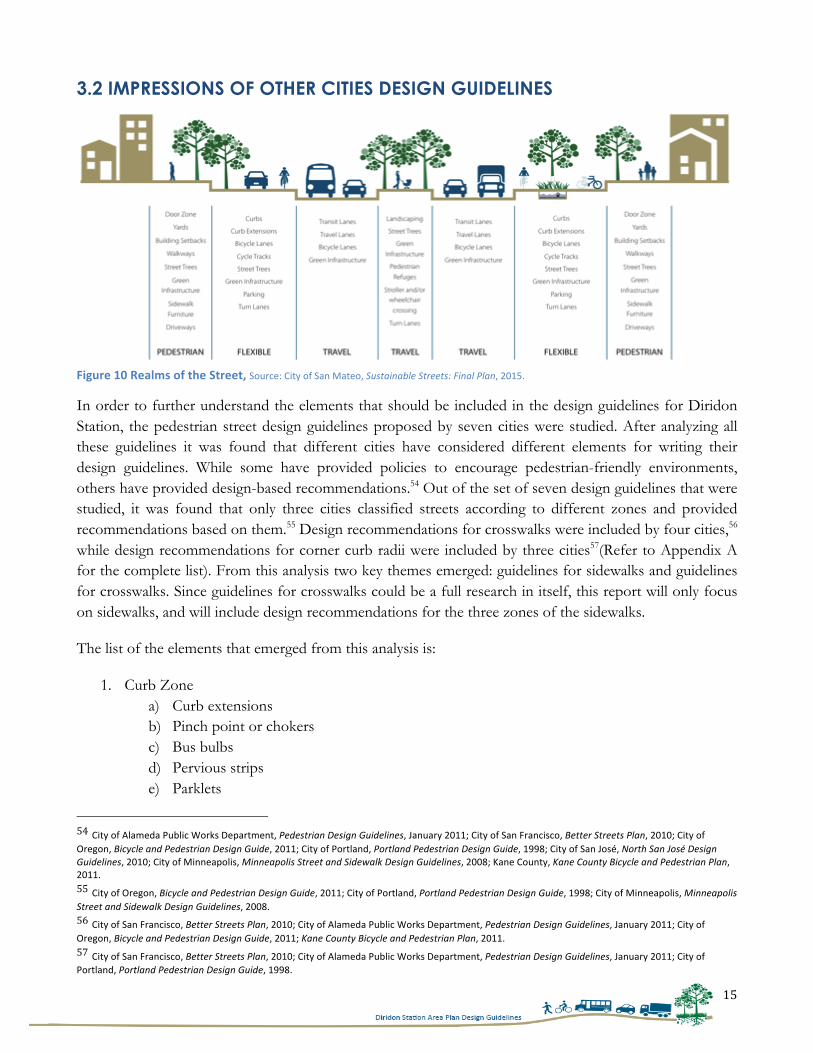
3.2 IMPRESSIONS OF OTHER CITIES DESIGN GUIDELINES
Figure 10 Realms of the Street, Source: City of San Mateo, Sustainable Streets: Final Plan, 2015.
In order to further understand the elements that should be included in the design guidelines for Diridon Station, the pedestrian street design guidelines proposed by seven cities were studied. After analyzing all these guidelines it was found that different cities have considered different elements for writing their design guidelines. While some have provided policies to encourage pedestrian-friendly environments, others have provided design-based recommendations.54 Out of the set of seven design guidelines that were studied, it was found that only three cities classified streets according to different zones and provided recommendations based on them.55 Design recommendations for crosswalks were included by four cities,56 while design recommendations for corner curb radii were included by three cities57(Refer to Appendix A for the complete list). From this analysis two key themes emerged: guidelines for sidewalks and guidelines for crosswalks. Since guidelines for crosswalks could be a full research in itself, this report will only focus on sidewalks, and will include design recommendations for the three zones of the sidewalks.
The list of the elements that emerged from this analysis is:
1. Curb Zone a) Curb extensions b) Pinch point or chokers c) Bus bulbs d) Pervious strips e) Parklets
54 City of Alameda Public Works Department, Pedestrian Design Guidelines, January 2011; City of San Francisco, Better Streets Plan, 2010; City of Oregon, Bicycle and Pedestrian Design Guide, 2011; City of Portland, Portland Pedestrian Design Guide, 1998; City of San José, North San José Design Guidelines, 2010; City of Minneapolis, Minneapolis Street and Sidewalk Design Guidelines, 2008; Kane County, Kane County Bicycle and Pedestrian Plan, 2011. 55 City of Oregon, Bicycle and Pedestrian Design Guide, 2011; City of Portland, Portland Pedestrian Design Guide, 1998; City of Minneapolis, Minneapolis Street and Sidewalk Design Guidelines, 2008. 56 City of San Francisco, Better Streets Plan, 2010; City of Alameda Public Works Department, Pedestrian Design Guidelines, January 2011; City of Oregon, Bicycle and Pedestrian Design Guide, 2011; Kane County Bicycle and Pedestrian Plan, 2011. 57 City of San Francisco, Better Streets Plan, 2010; City of Alameda Public Works Department, Pedestrian Design Guidelines, January 2011; City of Portland, Portland Pedestrian Design Guide, 1998.
16
f) Flow-through planters 2. Pedestrian Zone
a) Pervious pavements 3. Building Frontage Zone
a) Building canopies b) Awnings
These elements were finalized after studying different street design guidelines of other cities, conducting interviews and studying National Association for City Transportation Officials’ (NACTO) recommendations for converting streets into pedestrian-friendly streets. It is to be noted here that NACTO’s design standard has become the industry standard and is consulted by many cities while writing their design guidelines.58
This chapter provided a comprehensive list of all the street elements that should be included in the design guidelines for Diridon Station and the next chapter will discuss the vision of the City for the Diridon Station Area Plan.
58 Interview with Terry Bottomley, Principal at Bottomley and Associates, Oakland, CA, February 15th 2015.
17
CHAPTER 4 - DIRIDON STATION AREA PLAN (DSAP) In this chapter, the City’s vision for Diridon Station will be discussed. It will discuss the different zones planned by the City for this area. This chapter will also provide details of the streets, and the ways in which they will cater the upcoming traffic. The findings from this chapter will be used to strengthen the proposed Diridon Station Area Plan (DSAP), and provide specific design recommendations to help the City in achieving its vision for the DSAP.
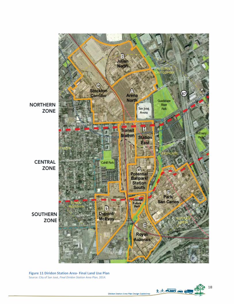
4.1 LAND USE DIAGRAM In the year 2008, the City of San José received grant funding from MTC as a part of their program to promote station area planning around BART stations.59 Soon after in November 2008, California voters approved proposition 1A for the initial funding of High Speed Rail (HSR).60 These events provided momentum for the City to develop the Diridon Station Area Plan (DSAP). In the DSAP the City has made a very robust plan for intensifying the land use of this area. For this purpose a new Ball Park Stadium, many hotels and commercial complexes are planned. The City also envisions developing more commercial development and shops on the ground floor to support pedestrian-friendly environments. To achieve these goals, City has divided DSAP into three zones, namely:
1. North Zone – Innovative Zone This will be the zone where all new developments will be promoted and many hotels and commercial centers will be encouraged for development. The City has proposed to develop Julian Street as the freeway access and business street of this zone. This street will connect people coming from north to Diridon Station.61
2. Central Zone – Destination Zone This is the zone where Diridon Station is located, and hence, the City wants to develop this area into a destination place where people can hang out and spend some quality time together. The City aims to develop The Alameda and Santa Clara Street as the access streets to downtown and will be locating major retail stores on these streets.
3. South Zone – Residential Zone In this zone all the new residential developments are planned, and this zone will serve as the transit adjacent housing supply for Diridon Station. San Carlos Street, which is the major street situated in this zone is envisioned to be developed as the street connecting to various neighborhoods and retail stores.
59 City of San José, Final Diridon Station Area Plan, 2014, pg. 1-‐3. 60 Ibid, pg. 1-‐3. 61 City of San José, Final Diridon Station Area Plan, 2014, pg. 1-‐3.
18
Figure 11 Diridon Station Area-‐ Final Land Use Plan
Source: City of San José, Final Diridon Station Area Plan, 2014.
19
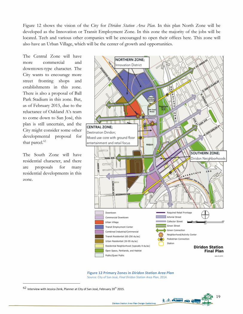
Figure 12 shows the vision of the City for Diridon Station Area Plan. In this plan North Zone will be developed as the Innovation or Transit Employment Zone. In this zone the majority of the jobs will be located. Tech and various other companies will be encouraged to open their offices here. This zone will also have an Urban Village, which will be the center of growth and opportunities. The Central Zone will have more commercial and downtown-type character. The City wants to encourage more street fronting shops and establishments in this zone. There is also a proposal of Ball Park Stadium in this zone. But, as of February 2015, due to the reluctance of Oakland A’s team to come down to San José, this plan is still uncertain, and the City might consider some other developmental proposal for that parcel.62 The South Zone will have residential character, and there are proposals for many residential developments in this zone.
62 Interview with Jessica Zenk, Planner at City of San José, February 20th 2015.
Figure 12 Primary Zones in Diridon Station Area Plan Source: City of San José, Final Diridon Station Area Plan, 2014.
20
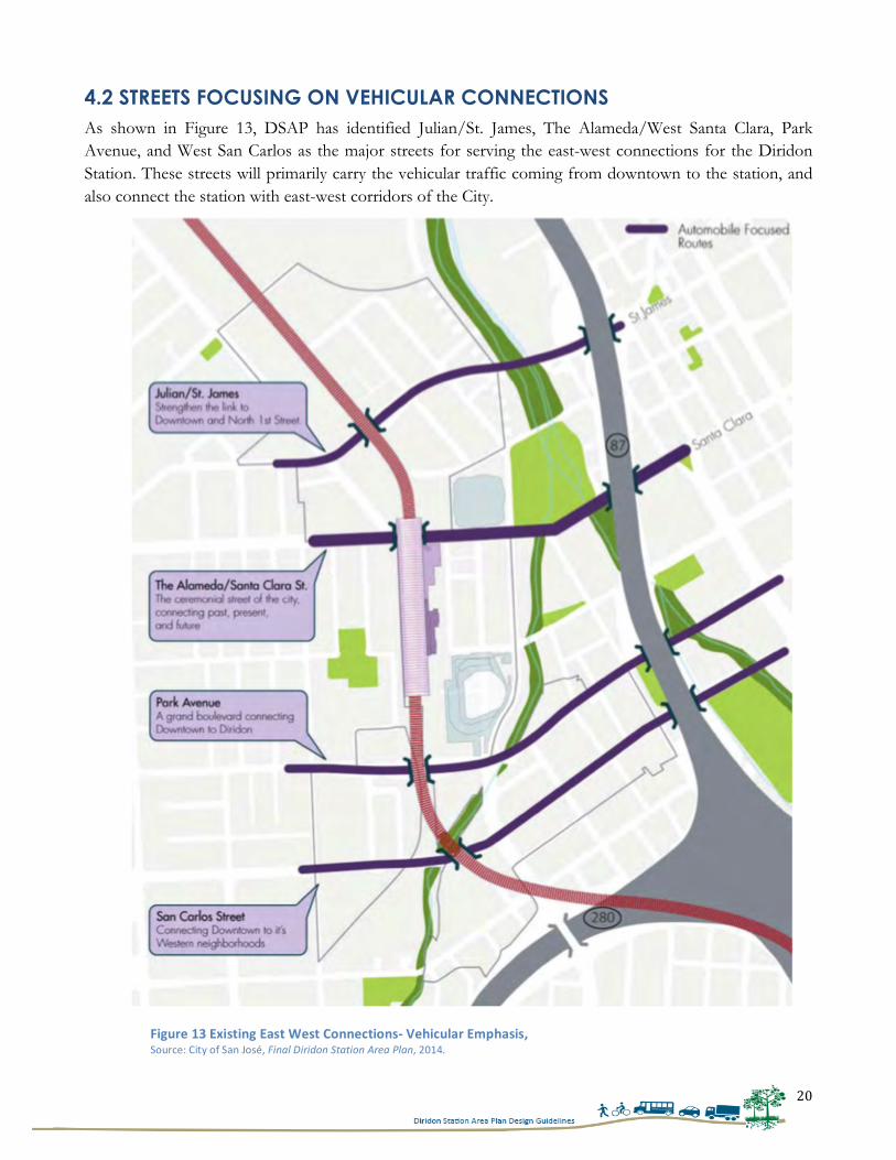
4.2 STREETS FOCUSING ON VEHICULAR CONNECTIONS As shown in Figure 13, DSAP has identified Julian/St. James, The Alameda/West Santa Clara, Park Avenue, and West San Carlos as the major streets for serving the east-west connections for the Diridon Station. These streets will primarily carry the vehicular traffic coming from downtown to the station, and also connect the station with east-west corridors of the City.
Figure 13 Existing East West Connections-‐ Vehicular Emphasis, Source: City of San José, Final Diridon Station Area Plan, 2014.
21
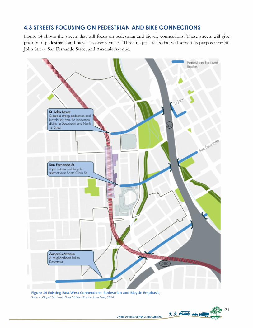
4.3 STREETS FOCUSING ON PEDESTRIAN AND BIKE CONNECTIONS Figure 14 shows the streets that will focus on pedestrian and bicycle connections. These streets will give priority to pedestrians and bicyclists over vehicles. Three major streets that will serve this purpose are: St. John Street, San Fernando Street and Auzerais Avenue.
Figure 14 Existing East West Connections-‐ Pedestrian and Bicycle Emphasis, Source: City of San José, Final Diridon Station Area Plan, 2014.
22
4.3 OTHER TYPE OF STREET CLASSIFICATIONS
Apart from identifying primary mode focus for each street, the DSAP also classified each street according to its use patterns. These classifications are as follows:
1. Cahill - Bicycle Boulevard 2. Montgomery - Bicycle boulevard 3. Autumn - City Connector 4. W San Fernando - On-Street Primary Bicycle Facility 5. Park Avenue - On-Street Primary Bicycle Facility 6. W San Carlos - Grand Boulevard 7. Auzerais Avenue - Local Connector Street 8. Delmas Avenue - Main Street 9. The Alameda - Grand Boulevard 10. E Santa Clara - Grand Boulevard 11. W Julian Street - Local Connector/ City Connector Street 12. Bird Avenue - City Connector Street
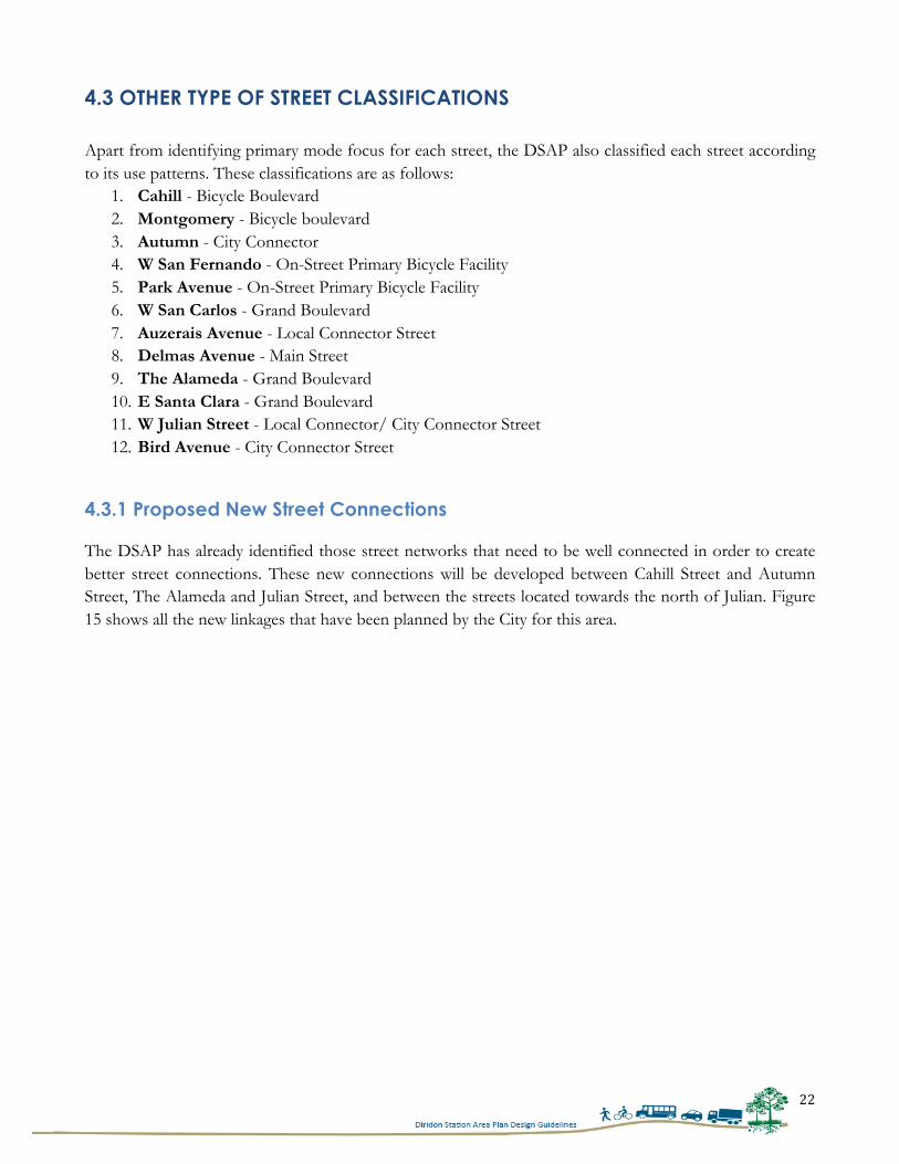
4.3.1 Proposed New Street Connections The DSAP has already identified those street networks that need to be well connected in order to create better street connections. These new connections will be developed between Cahill Street and Autumn Street, The Alameda and Julian Street, and between the streets located towards the north of Julian. Figure 15 shows all the new linkages that have been planned by the City for this area.
23
Figure 15 Proposed new street connections, Source: City of San José, Final Diridon Station Area Plan, 2014.
24
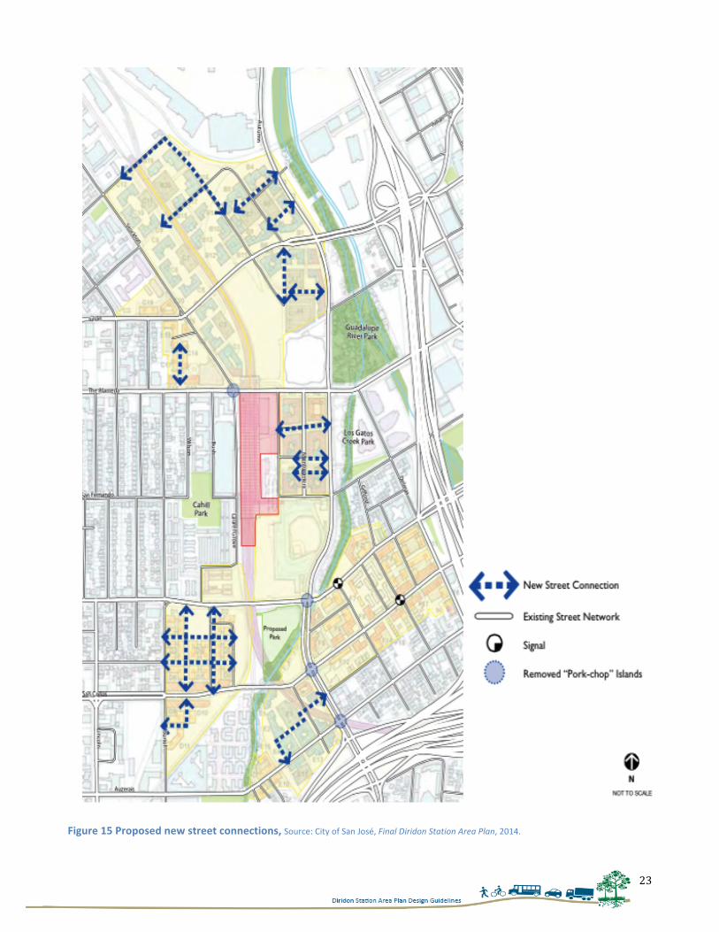
4.3.2 Proposed Improvements in Pedestrian Networks The City has also identified intersections that need improvements around the station. These intersections include intersection of Cahill and Santa Clara, intersection of Autumn and Santa Clara, and intersections that lead to the parking lots of the Diridon Station. These intersections are shown in Figure 16.
Figure 16 Walking connections, Source: City of San José, Final Diridon Station Area Plan, 2014.
25
4.4 TAKE AWAY FOR PROPOSING DESIGN GUIDELINES The Diridon Station Area Plan has done a good job in identifying pedestrian connections and strengthening those connections. The plan has also identified three zones and defined their purpose. Now, in order to further make these zones fully functional, it is necessary to develop separate design characteristics for each zone. Currently, parking lots around Diridon Station do not provide an inviting environment for people to stay in this area. Also, buildings around this area are mostly vacant or are under utilized which creates an unwelcoming environment for the visitors. It is only because of adjacent SAP Center that people come to this area for fulfilling their recreational interests. In order to provide a character to this area and convert it into pedestrian-friendly space, it is really important to wisely design the surrounding streets, and build spaces where people can spend quality time together. This can be done by building an open plaza in front of the Diridon Station and intensifying this area with more commercial and retail establishments. By doing so, we can create more opportunities for people to stay in this area. Looking into the design characteristics of each street and building a strong pedestrian-centric environment is important to encourage more pedestrian activities. Therefore, in the next chapter strengths and weaknesses of each street will be discussed to find out what works nicely on these streets and what needs to be changed, in order to build a strong pedestrian-centric environment. To study these factors the next chapter will discuss the site visit conducted by the author to find out the potential for improvements in each street. The observation elements included in the site visit were developed using the findings from Chapter 2 and 3 of this report.
26
CHAPTER 5 - SITE VISIT This chapter includes the observations made by the author during the site visit. Here current conditions of each street were recorded using a checklist of ten elements. This checklist was developed containing only those street elements that came out from the findings of author’s literature review, such as presence of buffer lanes, presence of trees, condition of sidewalks, etc. These elements are important to study to find out pedestrians’ walking experiences on the streets. Through this process the author seeks to gain deeper understanding of the study area and this understanding will be useful in developing specific design recommendations for each street in the later chapters of the report.
5.1 METHODOLOGY ADOPTED FOR CONDUCTING THE SITE VISIT From the literature review it was found that presence of safety, elements of visual interest and presence of pedestrian scale elements helps in encouraging more pedestrian activities on the streets. Therefore, while conducting the site visit street elements that increase safety, that are aesthetically pleasing, and that are designed according to pedestrian scale were recorded. Following is the detailed list of those elements: Safety- For providing safety from vehicular traffic having buffering between the sidewalks and the roadways is essential. This could be achieved by having either bike lanes, or street trees that act as a buffer between them. Having more street fronting windows, and absence of blank walls facing sidewalks, could also be helpful in increasing more eyes on the sidewalks, and in turn help in reducing crime issues in the community. Few other elements such as marked crosswalks also helps in improving pedestrian safety, as it helps in delineating the territory of the pedestrians and reducing vehicular and pedestrian clashes. Elements of visual interest- Green spaces, small shrubs and surrounding building elements could also help in increasing the visual interest of the streets, and in turn encourage more people to walk on the streets. Therefore these elements were recorded during the site visit. Presence of street elements- Having street elements such as seating spaces helps in providing temporary rest spaces to the pedestrians and supports more pedestrian activities. In order to study these streets, the author conducted a walking tour and used a checklist to understand different street characteristics. On all the twelve streets studied for this research, the author picked up a point and recorded some general observations at that point (shown in Figure 18). The author randomly picked these observation points. These observations were done on two days, one on a weekday, and another on a weekend. This whole process took the author a total of eight hours in completing all the components of the checklist.
27
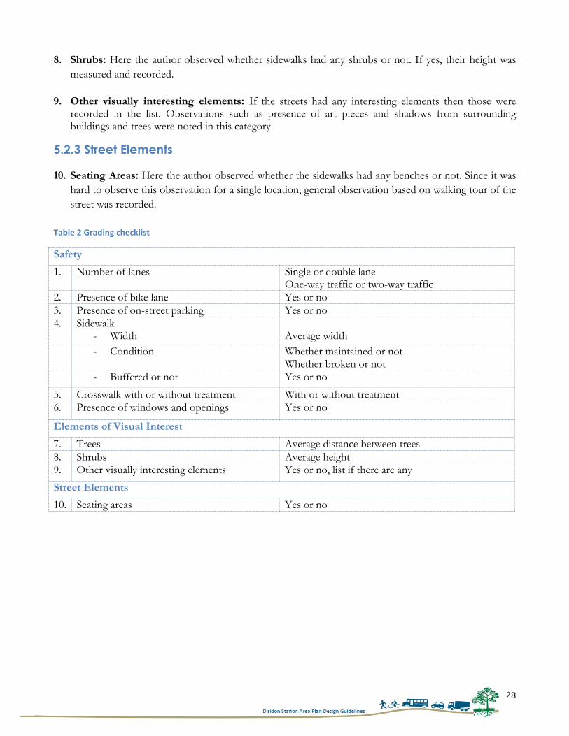
5.2 STREETS GRADING CRITERIA In order to observe the streets, a checklist containing ten categories was prepared. These categories were based on the three themes and their description is as follows:
5.2.1 Safety 1. Number of travel lanes: Here number of travel lanes was recorded. The grading category included
single, double or multiple lane. This category is useful in analyzing traffic condition of the streets and in turn helpful in studying the safety concerns for pedestrians.
2. Presence of bike lanes/bike racks: Presence of bike lanes or bike racks was noted under this
category. The bike lanes and racks act as a safety buffer for pedestrians and therefore they were recorded in the site visit.
3. Presence of on-street parking: Presence of on-street parking works similar as bike lanes in providing
buffer to pedestrians.
4. Sidewalk: Here presence of sidewalks, their condition, width and continuity was recorded. These criteria help in analyzing various factors, such as ease of travelling on the sidewalks and upkeep of the neighborhood. Since sidewalks are important to consider from the perspective of crime and vehicular safety, therefore it was included in the observation list.
5. Crosswalk with or without treatment: There
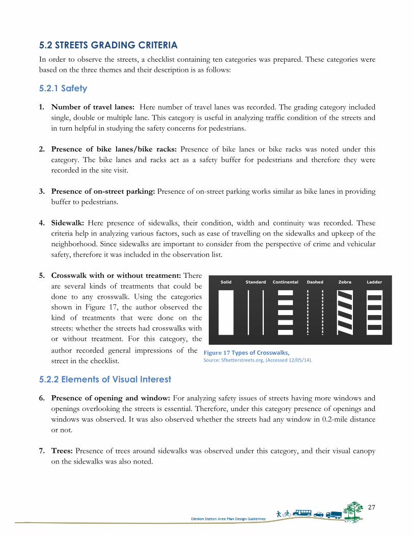
are several kinds of treatments that could be done to any crosswalk. Using the categories shown in Figure 17, the author observed the kind of treatments that were done on the streets: whether the streets had crosswalks with or without treatment. For this category, the author recorded general impressions of the street in the checklist.
5.2.2 Elements of Visual Interest
6. Presence of opening and window: For analyzing safety issues of streets having more windows and openings overlooking the streets is essential. Therefore, under this category presence of openings and windows was observed. It was also observed whether the streets had any window in 0.2-mile distance or not.
7. Trees: Presence of trees around sidewalks was observed under this category, and their visual canopy on the sidewalks was also noted.
Figure 17 Types of Crosswalks, Source: Sfbetterstreets.org, (Accessed 12/05/14).
28
8. Shrubs: Here the author observed whether sidewalks had any shrubs or not. If yes, their height was measured and recorded.
9. Other visually interesting elements: If the streets had any interesting elements then those were
recorded in the list. Observations such as presence of art pieces and shadows from surrounding buildings and trees were noted in this category.
5.2.3 Street Elements 10. Seating Areas: Here the author observed whether the sidewalks had any benches or not. Since it was
hard to observe this observation for a single location, general observation based on walking tour of the street was recorded.
Table 2 Grading checklist
Safety
1. Number of lanes Single or double lane One-way traffic or two-way traffic
2. Presence of bike lane Yes or no 3. Presence of on-street parking Yes or no 4. Sidewalk
- Width Average width
- Condition Whether maintained or not Whether broken or not
- Buffered or not Yes or no
5. Crosswalk with or without treatment With or without treatment 6. Presence of windows and openings Yes or no
Elements of Visual Interest
7. Trees Average distance between trees 8. Shrubs Average height 9. Other visually interesting elements Yes or no, list if there are any
Street Elements
10. Seating areas Yes or no
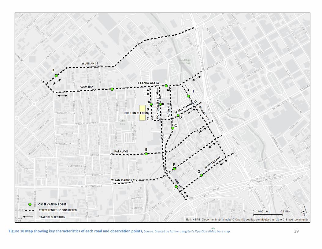
29 Figure 18 Map showing key characteristics of each road and observation points, Source: Created by Author using Esri’s OpenStreetMap base map.
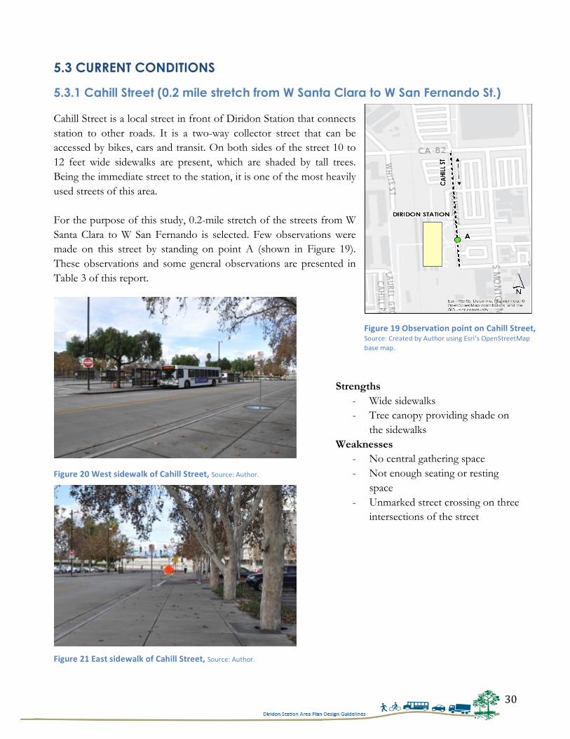
30
5.3 CURRENT CONDITIONS
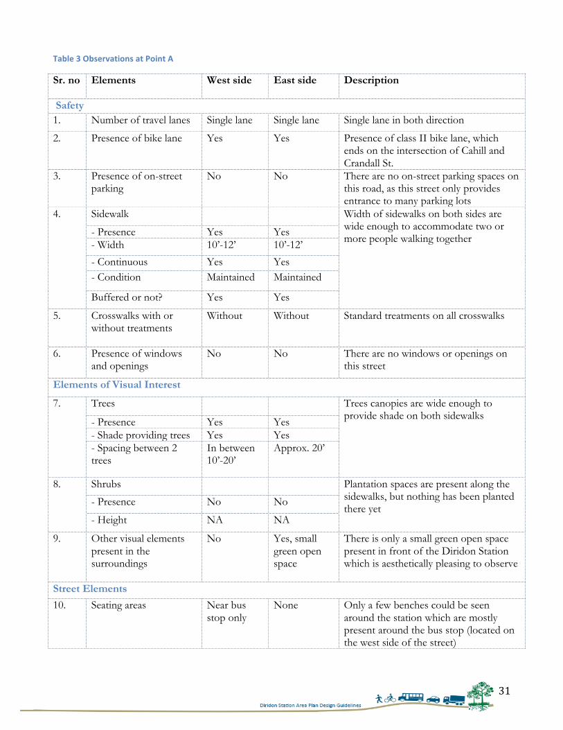
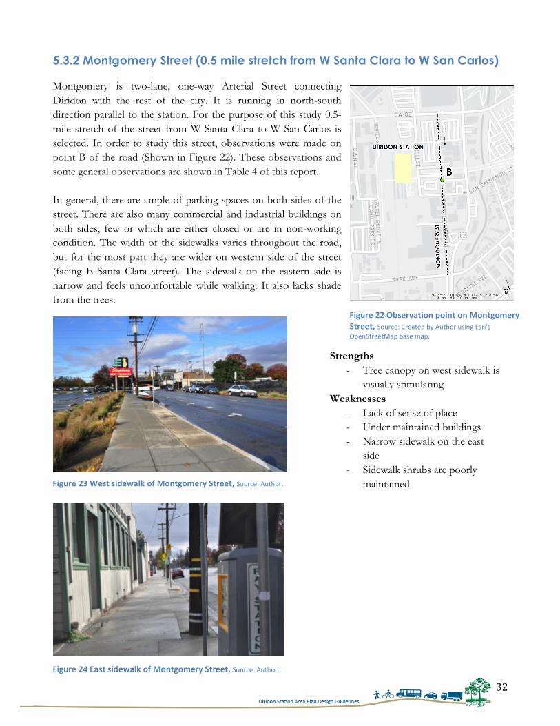
5.3.1 Cahill Street (0.2 mile stretch from W Santa Clara to W San Fernando St.) Cahill Street is a local street in front of Diridon Station that connects station to other roads. It is a two-way collector street that can be accessed by bikes, cars and transit. On both sides of the street 10 to 12 feet wide sidewalks are present, which are shaded by tall trees. Being the immediate street to the station, it is one of the most heavily used streets of this area. For the purpose of this study, 0.2-mile stretch of the streets from W Santa Clara to W San Fernando is selected. Few observations were made on this street by standing on point A (shown in Figure 19). These observations and some general observations are presented in Table 3 of this report.
Strengths - Wide sidewalks - Tree canopy providing shade on
the sidewalks Weaknesses
- No central gathering space - Not enough seating or resting
space - Unmarked street crossing on three
intersections of the street
Figure 19 Observation point on Cahill Street, Source: Created by Author using Esri’s OpenStreetMap base map.
Figure 21 East sidewalk of Cahill Street, Source: Author.
Figure 20 West sidewalk of Cahill Street, Source: Author.
31
Table 3 Observations at Point A
Sr. no Elements West side East side
Description
Safety 1. Number of travel lanes Single lane Single lane Single lane in both direction
2. Presence of bike lane Yes Yes Presence of class II bike lane, which ends on the intersection of Cahill and Crandall St.
3. Presence of on-street parking
No No There are no on-street parking spaces on this road, as this street only provides entrance to many parking lots
4. Sidewalk Width of sidewalks on both sides are wide enough to accommodate two or more people walking together
- Presence Yes Yes - Width 10’-12’ 10’-12’
- Continuous Yes Yes - Condition Maintained Maintained
Buffered or not? Yes Yes
5. Crosswalks with or without treatments
Without Without Standard treatments on all crosswalks
6. Presence of windows and openings
No No There are no windows or openings on this street
Elements of Visual Interest
7. Trees Trees canopies are wide enough to provide shade on both sidewalks - Presence Yes Yes
- Shade providing trees Yes Yes - Spacing between 2 trees
In between 10’-20’
Approx. 20’
8. Shrubs Plantation spaces are present along the sidewalks, but nothing has been planted there yet
- Presence No No
- Height NA NA
9. Other visual elements present in the surroundings
No Yes, small green open space
There is only a small green open space present in front of the Diridon Station which is aesthetically pleasing to observe
Street Elements
10. Seating areas Near bus stop only
None Only a few benches could be seen around the station which are mostly present around the bus stop (located on the west side of the street)
32
5.3.2 Montgomery Street (0.5 mile stretch from W Santa Clara to W San Carlos) Montgomery is two-lane, one-way Arterial Street connecting Diridon with the rest of the city. It is running in north-south direction parallel to the station. For the purpose of this study 0.5-mile stretch of the street from W Santa Clara to W San Carlos is selected. In order to study this street, observations were made on point B of the road (Shown in Figure 22). These observations and some general observations are shown in Table 4 of this report. In general, there are ample of parking spaces on both sides of the street. There are also many commercial and industrial buildings on both sides, few or which are either closed or are in non-working condition. The width of the sidewalks varies throughout the road, but for the most part they are wider on western side of the street (facing E Santa Clara street). The sidewalk on the eastern side is narrow and feels uncomfortable while walking. It also lacks shade from the trees.
Strengths - Tree canopy on west sidewalk is
visually stimulating Weaknesses
- Lack of sense of place - Under maintained buildings - Narrow sidewalk on the east
side - Sidewalk shrubs are poorly
maintained
Figure 22 Observation point on Montgomery Street, Source: Created by Author using Esri’s OpenStreetMap base map.
Figure 23 West sidewalk of Montgomery Street, Source: Author.
Figure 24 East sidewalk of Montgomery Street, Source: Author.
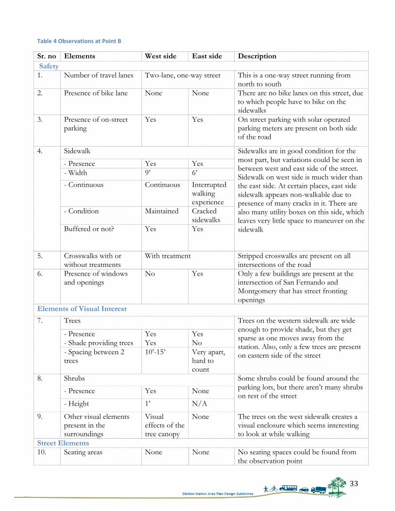
33
Table 4 Observations at Point B
Sr. no Elements West side East side Description Safety 1. Number of travel lanes Two-lane, one-way street This is a one-way street running from
north to south 2. Presence of bike lane None None There are no bike lanes on this street, due
to which people have to bike on the sidewalks
3. Presence of on-street parking
Yes Yes On street parking with solar operated parking meters are present on both side of the road
4. Sidewalk Sidewalks are in good condition for the most part, but variations could be seen in between west and east side of the street. Sidewalk on west side is much wider than the east side. At certain places, east side sidewalk appears non-walkable due to presence of many cracks in it. There are also many utility boxes on this side, which leaves very little space to maneuver on the sidewalk
- Presence Yes Yes - Width 9’ 6’
- Continuous Continuous Interrupted walking experience
- Condition Maintained Cracked sidewalks
Buffered or not? Yes Yes
5. Crosswalks with or without treatments
With treatment Stripped crosswalks are present on all intersections of the road
6. Presence of windows and openings
No Yes Only a few buildings are present at the intersection of San Fernando and Montgomery that has street fronting openings
Elements of Visual Interest
7. Trees Trees on the western sidewalk are wide enough to provide shade, but they get sparse as one moves away from the station. Also, only a few trees are present on eastern side of the street
- Presence Yes Yes - Shade providing trees Yes No - Spacing between 2 trees
10’-15’ Very apart, hard to count
8. Shrubs Some shrubs could be found around the parking lots, but there aren’t many shrubs on rest of the street
- Presence Yes None
- Height 1’ N/A
9. Other visual elements present in the surroundings
Visual effects of the tree canopy
None The trees on the west sidewalk creates a visual enclosure which seems interesting to look at while walking
Street Elements 10. Seating areas None None No seating spaces could be found from
the observation point
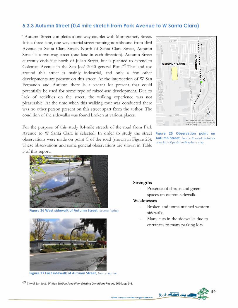
34
5.3.3 Autumn Street (0.4 mile stretch from Park Avenue to W Santa Clara)
“Autumn Street completes a one-way couplet with Montgomery Street. It is a three-lane, one-way arterial street running northbound from Bird Avenue to Santa Clara Street. North of Santa Clara Street, Autumn Street is a two-way street (one lane in each direction). Autumn Street currently ends just north of Julian Street, but is planned to extend to Coleman Avenue in the San José 2040 general Plan.”63 The land use around this street is mainly industrial, and only a few other developments are present on this street. At the intersection of W San Fernando and Autumn there is a vacant lot present that could potentially be used for some type of mixed-use development. Due to lack of activities on the street, the walking experience was not pleasurable. At the time when this walking tour was conducted there was no other person present on this street apart from the author. The condition of the sidewalks was found broken at various places. For the purpose of this study 0.4-mile stretch of the road from Park Avenue to W Santa Clara is selected. In order to study the street observations were made on point C of the road (shown in Figure 25). These observations and some general observations are shown in Table 5 of this report.
63 City of San José, Diridon Station Area Plan: Existing Conditions Report, 2010, pg. 5-‐3.
Strengths - Presence of shrubs and green
spaces on eastern sidewalk Weaknesses
- Broken and unmaintained western sidewalk
- Many cuts in the sidewalks due to entrances to many parking lots
Figure 25 Observation point on Autumn Street, Source: Created by Author using Esri’s OpenStreetMap base map.
Figure 26 West sidewalk of Autumn Street, Source: Author.
Figure 27 East sidewalk of Autumn Street, Source: Author.
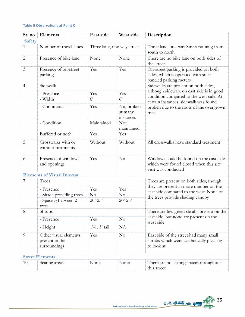
35
Table 5 Observations at Point C
Sr. no Elements East side West side Description Safety 1. Number of travel lanes Three lane, one-way street Three lane, one-way Street running from
south to north 2. Presence of bike lane None None There are no bike lane on both sides of
the street 3. Presence of on-street
parking Yes Yes On-street parking is provided on both
sides, which is operated with solar paneled parking meters
4. Sidewalk Sidewalks are present on both sides, although sidewalk on east side is in good condition compared to the west side. At certain instances, sidewalk was found broken due to the roots of the overgrown trees
- Presence Yes Yes - Width 6’ 6’
- Continuous Yes No, broken at many instances
- Condition Maintained Not maintained
Buffered or not? Yes Yes
5. Crosswalks with or without treatments
Without Without All crosswalks have standard treatment
6. Presence of windows and openings
Yes No Windows could be found on the east side which were found closed when this site visit was conducted
Elements of Visual Interest 7. Trees Trees are present on both sides, though
they are present in more number on the east side compared to the west. None of the trees provide shading canopy
- Presence Yes Yes - Shade providing trees No No - Spacing between 2 trees
20’-25’ 20’-25’
8. Shrubs There are few green shrubs present on the east side, but none are present on the west side
- Presence Yes No
- Height 1’-1. 5’ tall NA
9. Other visual elements present in the surroundings
Yes No East side of the street had many small shrubs which were aesthetically pleasing to look at
Street Elements 10. Seating areas None None There are no seating spaces throughout
this street
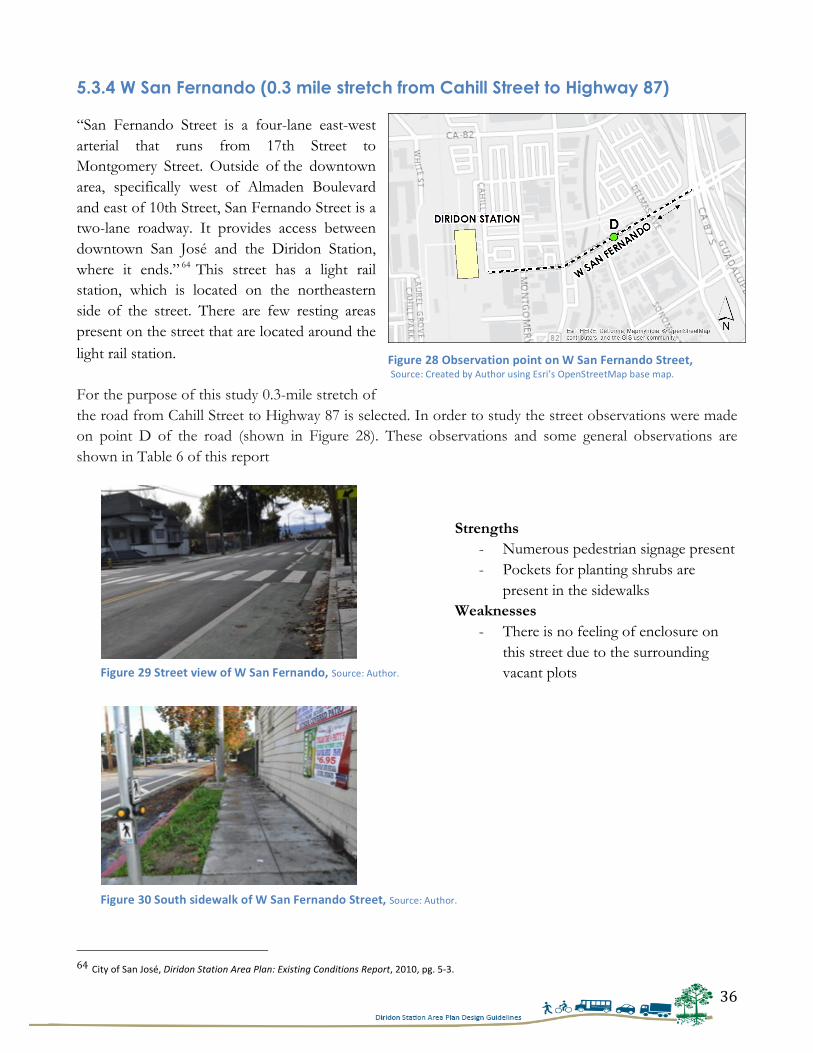
36
5.3.4 W San Fernando (0.3 mile stretch from Cahill Street to Highway 87) “San Fernando Street is a four-lane east-west arterial that runs from 17th Street to Montgomery Street. Outside of the downtown area, specifically west of Almaden Boulevard and east of 10th Street, San Fernando Street is a two-lane roadway. It provides access between downtown San José and the Diridon Station, where it ends.” 64 This street has a light rail station, which is located on the northeastern side of the street. There are few resting areas present on the street that are located around the light rail station. For the purpose of this study 0.3-mile stretch of the road from Cahill Street to Highway 87 is selected. In order to study the street observations were made on point D of the road (shown in Figure 28). These observations and some general observations are shown in Table 6 of this report
64 City of San José, Diridon Station Area Plan: Existing Conditions Report, 2010, pg. 5-‐3.
Strengths - Numerous pedestrian signage present - Pockets for planting shrubs are
present in the sidewalks Weaknesses
- There is no feeling of enclosure on this street due to the surrounding vacant plots
Figure 28 Observation point on W San Fernando Street, Source: Created by Author using Esri’s OpenStreetMap base map.
Figure 29 Street view of W San Fernando, Source: Author.
Figure 30 South sidewalk of W San Fernando Street, Source: Author.
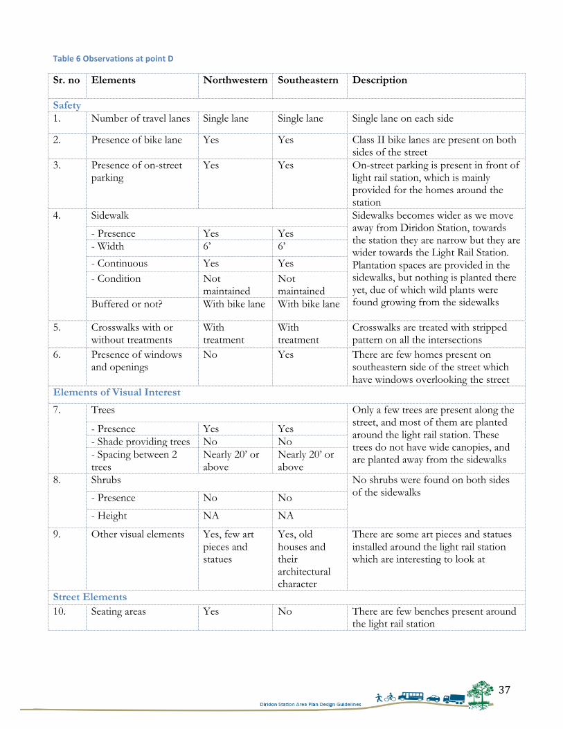
37
Table 6 Observations at point D
Sr. no Elements Northwestern
Southeastern
Description
Safety 1. Number of travel lanes Single lane Single lane Single lane on each side
2. Presence of bike lane Yes Yes Class II bike lanes are present on both sides of the street
3. Presence of on-street parking
Yes Yes On-street parking is present in front of light rail station, which is mainly provided for the homes around the station
4. Sidewalk Sidewalks becomes wider as we move away from Diridon Station, towards the station they are narrow but they are wider towards the Light Rail Station. Plantation spaces are provided in the sidewalks, but nothing is planted there yet, due of which wild plants were found growing from the sidewalks
- Presence Yes Yes - Width 6’ 6’
- Continuous Yes Yes - Condition Not
maintained Not maintained
Buffered or not? With bike lane With bike lane
5. Crosswalks with or without treatments
With treatment
With treatment
Crosswalks are treated with stripped pattern on all the intersections
6. Presence of windows and openings
No Yes There are few homes present on southeastern side of the street which have windows overlooking the street
Elements of Visual Interest
7. Trees Only a few trees are present along the street, and most of them are planted around the light rail station. These trees do not have wide canopies, and are planted away from the sidewalks
- Presence Yes Yes - Shade providing trees No No - Spacing between 2 trees
Nearly 20’ or above
Nearly 20’ or above
8. Shrubs No shrubs were found on both sides of the sidewalks
- Presence No No
- Height NA NA
9. Other visual elements Yes, few art pieces and statues
Yes, old houses and their architectural character
There are some art pieces and statues installed around the light rail station which are interesting to look at
Street Elements 10. Seating areas Yes No There are few benches present around
the light rail station
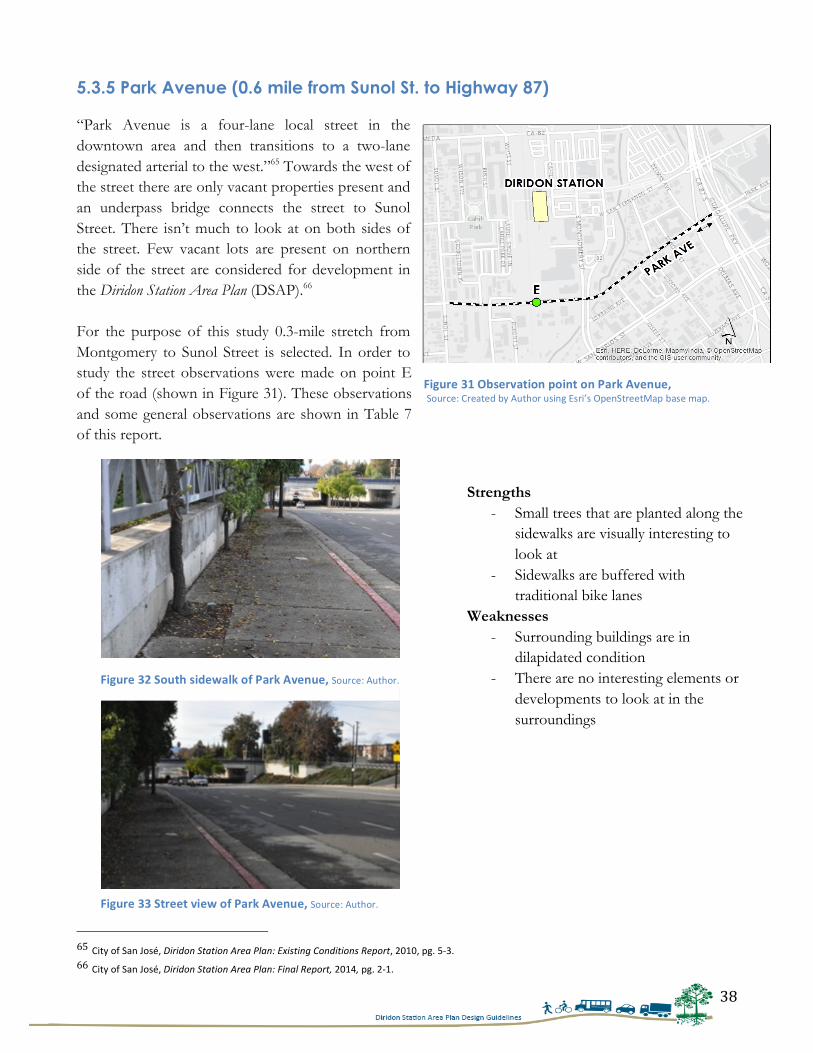
38
5.3.5 Park Avenue (0.6 mile from Sunol St. to Highway 87)
“Park Avenue is a four-lane local street in the downtown area and then transitions to a two-lane designated arterial to the west.”65 Towards the west of the street there are only vacant properties present and an underpass bridge connects the street to Sunol Street. There isn’t much to look at on both sides of the street. Few vacant lots are present on northern side of the street are considered for development in the Diridon Station Area Plan (DSAP).66 For the purpose of this study 0.3-mile stretch from Montgomery to Sunol Street is selected. In order to study the street observations were made on point E of the road (shown in Figure 31). These observations and some general observations are shown in Table 7 of this report.
65 City of San José, Diridon Station Area Plan: Existing Conditions Report, 2010, pg. 5-‐3. 66 City of San José, Diridon Station Area Plan: Final Report, 2014, pg. 2-‐1.
Strengths - Small trees that are planted along the
sidewalks are visually interesting to look at
- Sidewalks are buffered with traditional bike lanes
Weaknesses - Surrounding buildings are in
dilapidated condition - There are no interesting elements or
developments to look at in the surroundings
Figure 31 Observation point on Park Avenue, Source: Created by Author using Esri’s OpenStreetMap base map.
Figure 32 South sidewalk of Park Avenue, Source: Author.
Figure 33 Street view of Park Avenue, Source: Author.
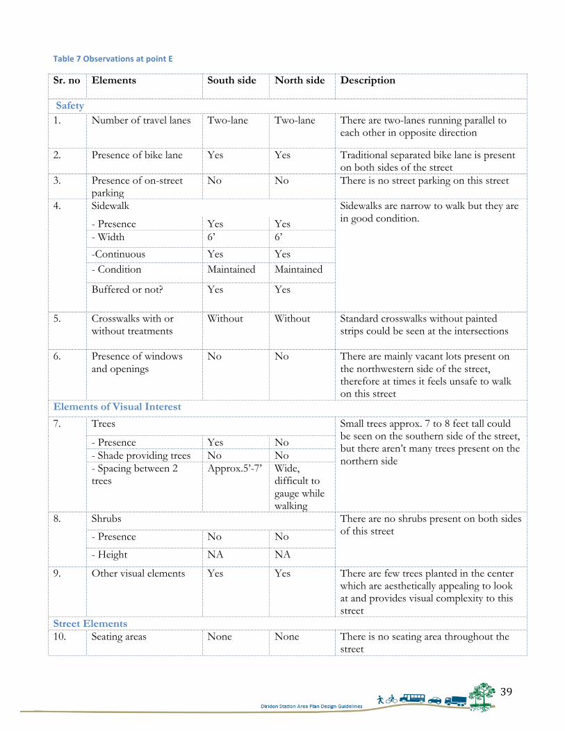
39
Table 7 Observations at point E
Sr. no Elements South side North side Description
Safety 1. Number of travel lanes Two-lane Two-lane There are two-lanes running parallel to
each other in opposite direction
2. Presence of bike lane Yes Yes Traditional separated bike lane is present on both sides of the street
3. Presence of on-street parking
No No There is no street parking on this street
4. Sidewalk Sidewalks are narrow to walk but they are in good condition.
- Presence Yes Yes - Width 6’ 6’
-Continuous Yes Yes - Condition Maintained Maintained
Buffered or not? Yes Yes
5. Crosswalks with or without treatments
Without Without Standard crosswalks without painted strips could be seen at the intersections
6. Presence of windows and openings
No No There are mainly vacant lots present on the northwestern side of the street, therefore at times it feels unsafe to walk on this street
Elements of Visual Interest
7. Trees Small trees approx. 7 to 8 feet tall could be seen on the southern side of the street, but there aren’t many trees present on the northern side
- Presence Yes No - Shade providing trees No No - Spacing between 2 trees
Approx.5’-7’ Wide, difficult to gauge while walking
8. Shrubs There are no shrubs present on both sides of this street - Presence No No
- Height NA NA
9. Other visual elements Yes Yes There are few trees planted in the center which are aesthetically appealing to look at and provides visual complexity to this street
Street Elements 10. Seating areas None None There is no seating area throughout the
street
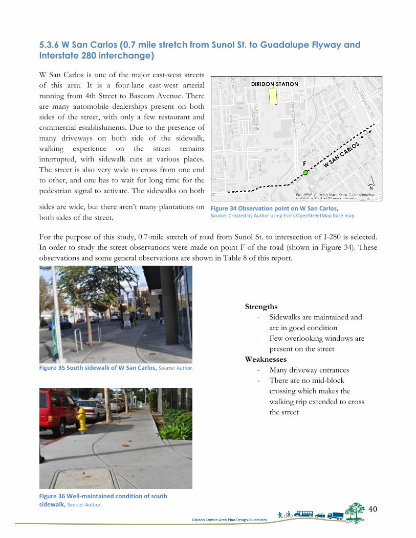
40
5.3.6 W San Carlos (0.7 mile stretch from Sunol St. to Guadalupe Flyway and Interstate 280 interchange)
W San Carlos is one of the major east-west streets of this area. It is a four-lane east-west arterial running from 4th Street to Bascom Avenue. There are many automobile dealerships present on both sides of the street, with only a few restaurant and commercial establishments. Due to the presence of many driveways on both side of the sidewalk, walking experience on the street remains interrupted, with sidewalk cuts at various places. The street is also very wide to cross from one end to other, and one has to wait for long time for the pedestrian signal to activate. The sidewalks on both
sides are wide, but there aren’t many plantations on both sides of the street.
For the purpose of this study, 0.7-mile stretch of road from Sunol St. to intersection of I-280 is selected. In order to study the street observations were made on point F of the road (shown in Figure 34). These observations and some general observations are shown in Table 8 of this report.
Strengths - Sidewalks are maintained and
are in good condition - Few overlooking windows are
present on the street Weaknesses
- Many driveway entrances - There are no mid-block
crossing which makes the walking trip extended to cross the street
Figure 34 Observation point on W San Carlos, Source: Created by Author using Esri’s OpenStreetMap base map.
Figure 35 South sidewalk of W San Carlos, Source: Author.
Figure 36 Well-‐maintained condition of south sidewalk, Source: Author.
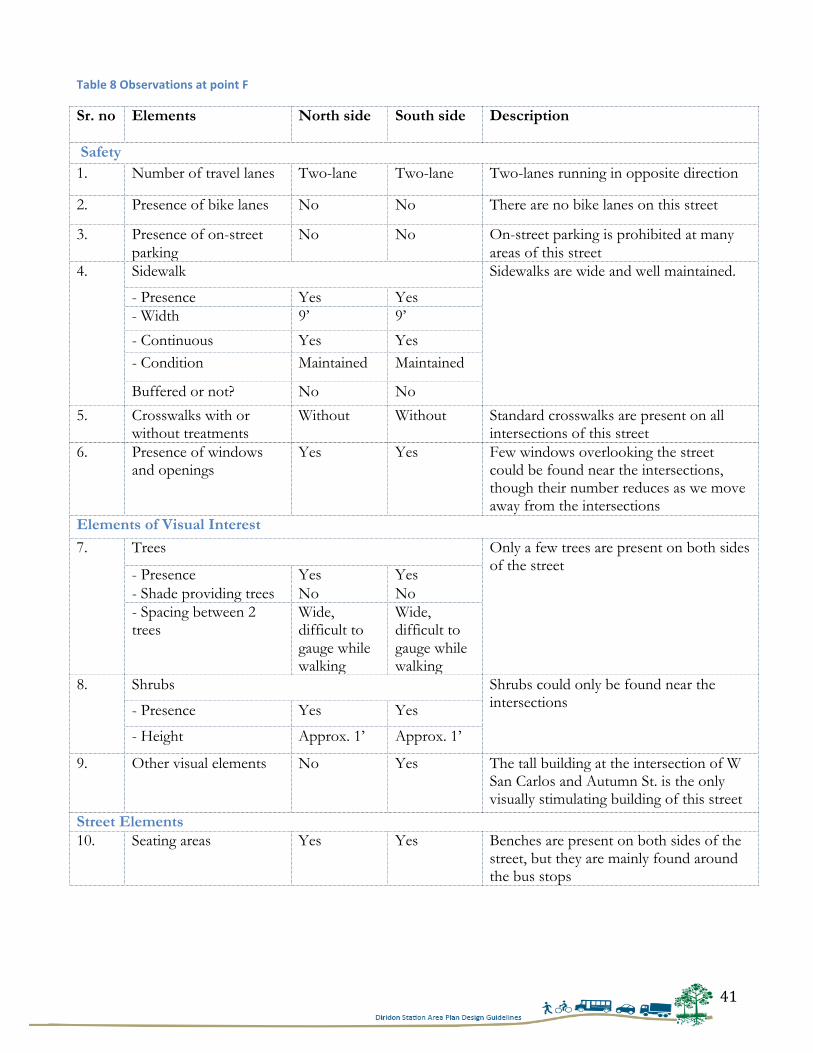
41
Table 8 Observations at point F
Sr. no Elements North side South side Description
Safety 1. Number of travel lanes Two-lane Two-lane Two-lanes running in opposite direction
2. Presence of bike lanes No No There are no bike lanes on this street
3. Presence of on-street parking
No No On-street parking is prohibited at many areas of this street
4. Sidewalk Sidewalks are wide and well maintained.
- Presence Yes Yes - Width 9’ 9’
- Continuous Yes Yes - Condition Maintained Maintained
Buffered or not? No No
5. Crosswalks with or without treatments
Without Without Standard crosswalks are present on all intersections of this street
6. Presence of windows and openings
Yes Yes Few windows overlooking the street could be found near the intersections, though their number reduces as we move away from the intersections
Elements of Visual Interest 7. Trees Only a few trees are present on both sides
of the street - Presence Yes Yes - Shade providing trees No No - Spacing between 2 trees
Wide, difficult to gauge while walking
Wide, difficult to gauge while walking
8. Shrubs Shrubs could only be found near the intersections - Presence Yes Yes
- Height Approx. 1’ Approx. 1’
9. Other visual elements No Yes The tall building at the intersection of W San Carlos and Autumn St. is the only visually stimulating building of this street
Street Elements 10. Seating areas Yes Yes Benches are present on both sides of the
street, but they are mainly found around the bus stops
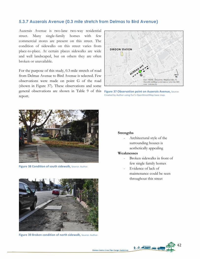
42
5.3.7 Auzerais Avenue (0.3 mile stretch from Delmas to Bird Avenue)
Auzerais Avenue is two-lane two-way residential street. Many single-family homes with few commercial stores are present on this street. The condition of sidewalks on this street varies from place-to-place. At certain places sidewalks are wide and well landscaped, but on others they are often broken or unavailable.
For the purpose of this study, 0.3-mile stretch of road from Delmas Avenue to Bird Avenue is selected. Few observations were made on point G of the road (shown in Figure 37). These observations and some general observations are shown in Table 9 of this report.
Strengths - Architectural style of the
surrounding houses is aesthetically appealing
Weaknesses - Broken sidewalks in front of
few single family homes - Evidence of lack of
maintenance could be seen throughout this street
Figure 37 Observation point on Auzerais Avenue, Source: Created by Author using Esri’s OpenStreetMap base map.
Figure 38 Condition of south sidewalk, Source: Author.
Figure 39 Broken condition of north sidewalk, Source: Author.
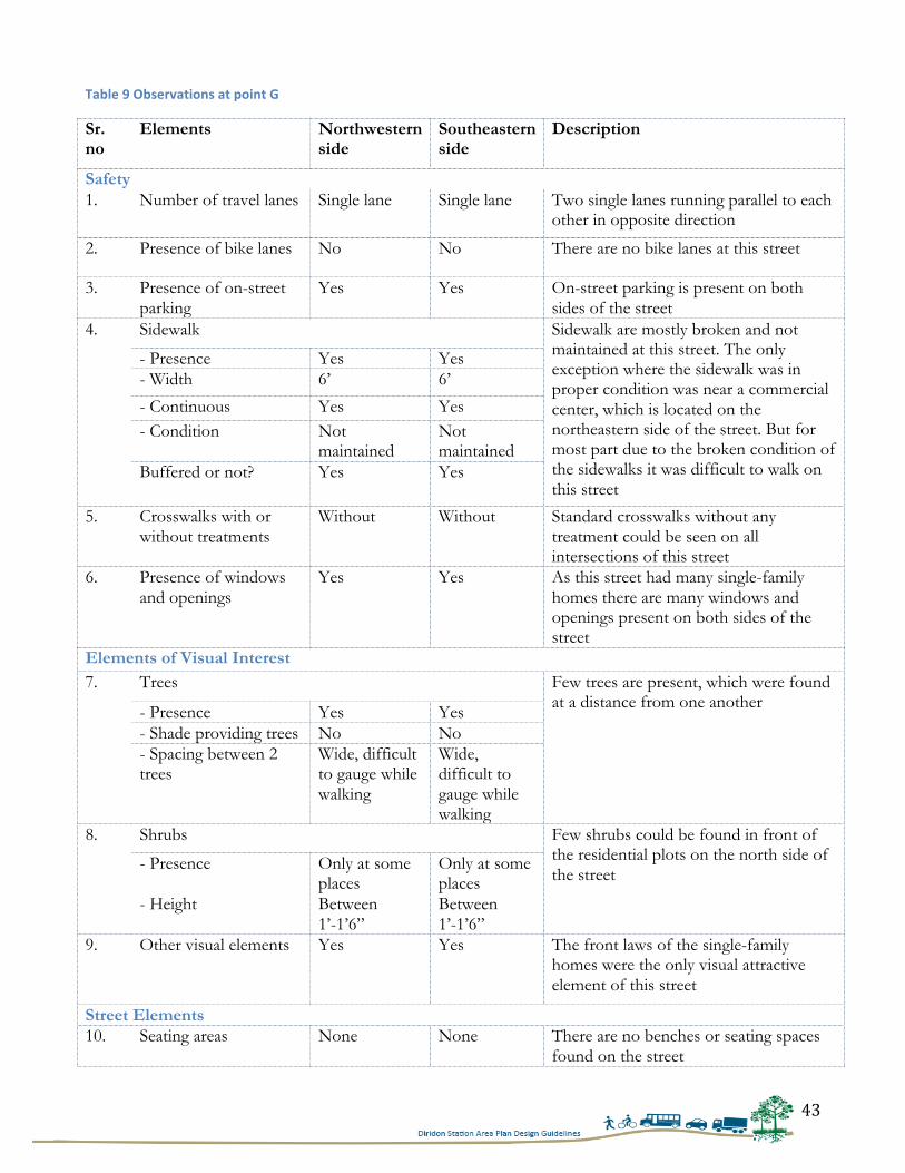
43
Table 9 Observations at point G
Sr. no
Elements Northwestern side
Southeastern side
Description
Safety 1. Number of travel lanes Single lane Single lane Two single lanes running parallel to each
other in opposite direction
2. Presence of bike lanes No No There are no bike lanes at this street
3. Presence of on-street parking
Yes Yes On-street parking is present on both sides of the street
4. Sidewalk Sidewalk are mostly broken and not maintained at this street. The only exception where the sidewalk was in proper condition was near a commercial center, which is located on the northeastern side of the street. But for most part due to the broken condition of the sidewalks it was difficult to walk on this street
- Presence Yes Yes - Width 6’ 6’
- Continuous Yes Yes - Condition Not
maintained Not maintained
Buffered or not? Yes Yes
5. Crosswalks with or without treatments
Without Without Standard crosswalks without any treatment could be seen on all intersections of this street
6. Presence of windows and openings
Yes Yes As this street had many single-family homes there are many windows and openings present on both sides of the street
Elements of Visual Interest 7. Trees Few trees are present, which were found
at a distance from one another - Presence Yes Yes - Shade providing trees No No - Spacing between 2 trees
Wide, difficult to gauge while walking
Wide, difficult to gauge while walking
8. Shrubs Few shrubs could be found in front of the residential plots on the north side of the street
- Presence Only at some places
Only at some places
- Height Between 1’-1’6”
Between 1’-1’6”
9. Other visual elements Yes Yes The front laws of the single-family homes were the only visual attractive element of this street
Street Elements 10. Seating areas None None There are no benches or seating spaces
found on the street
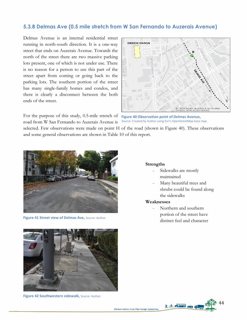
44
5.3.8 Delmas Ave (0.5 mile stretch from W San Fernando to Auzerais Avenue) Delmas Avenue is an internal residential street running in north-south direction. It is a one-way street that ends on Auzerais Avenue. Towards the north of the street there are two massive parking lots present, one of which is not under use. There is no reason for a person to use this part of the street apart from coming or going back to the parking lots. The southern portion of the street has many single-family homes and condos, and there is clearly a disconnect between the both ends of the street.
For the purpose of this study, 0.5-mile stretch of road from W San Fernando to Auzerais Avenue is selected. Few observations were made on point H of the road (shown in Figure 40). These observations and some general observations are shown in Table 10 of this report.
Strengths - Sidewalks are mostly
maintained - Many beautiful trees and
shrubs could be found along the sidewalks
Weaknesses - Northern and southern
portion of the street have distinct feel and character
Figure 40 Observation point of Delmas Avenue, Source: Created by Author using Esri’s OpenStreetMap base map.
Figure 41 Street view of Delmas Ave, Source: Author.
Figure 42 Southwestern sidewalk, Source: Author.
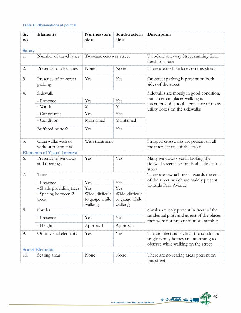
45
Table 10 Observations at point H
Sr. no
Elements Northeastern side
Southwestern side
Description
Safety 1. Number of travel lanes Two-lane one-way street Two-lane one-way Street running from
north to south 2. Presence of bike lanes None None There are no bike lanes on this street
3. Presence of on-street parking
Yes Yes On-street parking is present on both sides of the street
4. Sidewalk Sidewalks are mostly in good condition, but at certain places walking is interrupted due to the presence of many utility boxes on the sidewalks
- Presence Yes Yes - Width 6’ 6’
- Continuous Yes Yes - Condition Maintained Maintained
Buffered or not? Yes Yes
5. Crosswalks with or without treatments
With treatment
Stripped crosswalks are present on all the intersections of the street
Elements of Visual Interest 6. Presence of windows
and openings Yes Yes Many windows overall looking the
sidewalks were seen on both sides of the street
7. Trees There are few tall trees towards the end of the street, which are mainly present towards Park Avenue - Presence Yes Yes
- Shade providing trees Yes Yes - Spacing between 2 trees
Wide, difficult to gauge while walking
Wide, difficult to gauge while walking
8. Shrubs Shrubs are only present in front of the residential plots and at rest of the places they were not present in more number
- Presence Yes Yes
- Height Approx. 1’ Approx. 1’
9. Other visual elements Yes Yes The architectural style of the condo and single-family homes are interesting to observe while walking on the street
Street Elements 10. Seating areas None None There are no seating areas present on
this street

46
5.3.9 The Alameda (0.5 mile stretch from Julian to Stockton Ave.) The Alameda or State Route 87 is a four-lane north-south arterial road running from Santa Clara University to the Diridon Station. Before the station this street crosses an underpass and converts into W Santa Clara Street.67 After the walking tour it was found that this street is the most pedestrian-friendly street among all the streets studied for this research. There are few mixed-use developments present, which provide a good walking experience due to their scale and building materials. Over the past one-year this street has undergone modest changes and have upgraded the sidewalk facilities, due
to which it already provides a pedestrian-friendly environment.
For the purpose of this study, 0.5-mile stretch of road from Julian to Stockton Avenue is selected. Few observations were made on point I of the road (shown in Figure 43). These observations and some general observations are shown in Table 11 of this report.
67 City of San José, Diridon Station Area Plan: Existing Conditions Report, 2010, pg. 5-‐3.
Strengths - Sidewalks are
well buffered by the trees
- Sidewalks are in good condition
Weaknesses - Vehicles were
found speeding at the intersections
I
Figure 43 Observation point on The Alameda, Source: Created by Author using Esri’s OpenStreetMap base map.
Figure 44 Condition of The Alameda in July 2014, photo taken facing I-‐880, Source: Google Maps.
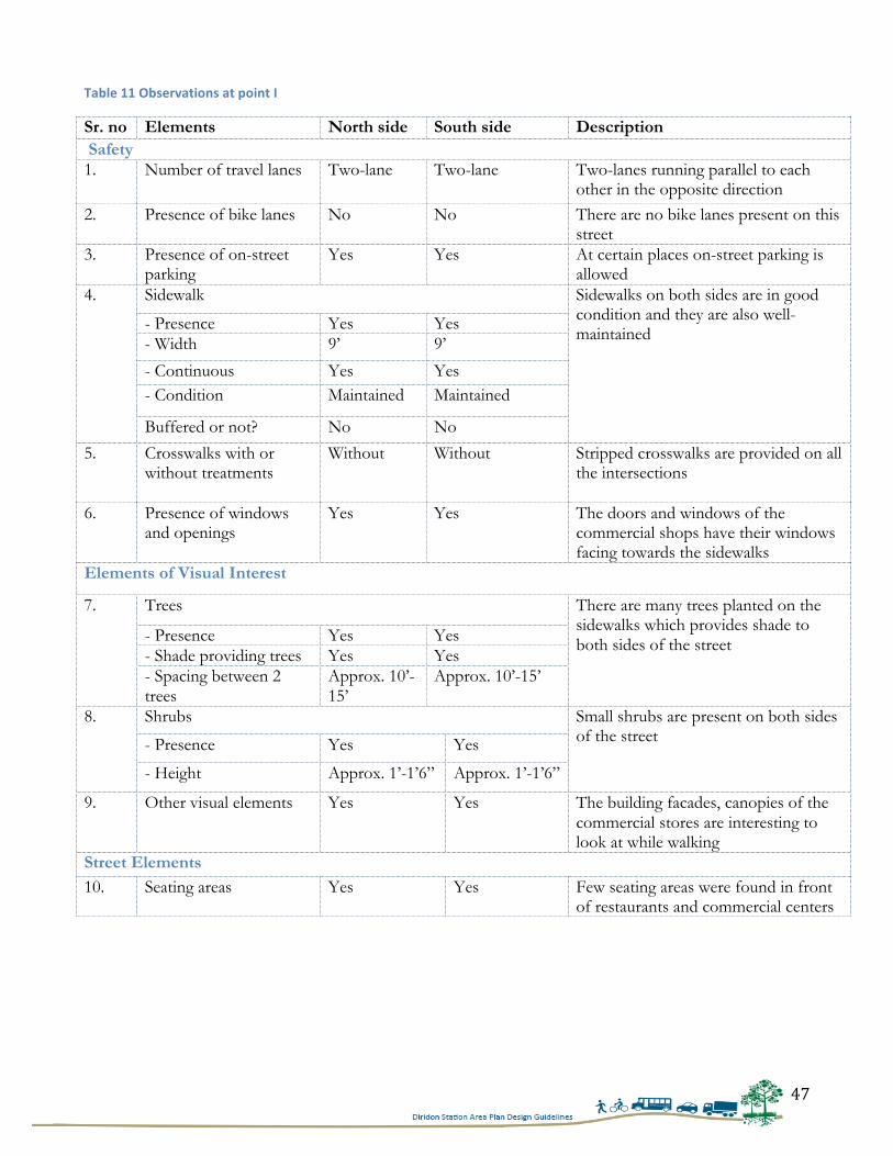
47
Table 11 Observations at point I
Sr. no Elements North side South side Description Safety 1. Number of travel lanes Two-lane Two-lane Two-lanes running parallel to each
other in the opposite direction 2. Presence of bike lanes No No There are no bike lanes present on this
street 3. Presence of on-street
parking Yes Yes At certain places on-street parking is
allowed 4. Sidewalk Sidewalks on both sides are in good
condition and they are also well-maintained
- Presence Yes Yes - Width 9’ 9’
- Continuous Yes Yes - Condition Maintained Maintained
Buffered or not? No No
5. Crosswalks with or without treatments
Without Without Stripped crosswalks are provided on all the intersections
6. Presence of windows and openings
Yes Yes The doors and windows of the commercial shops have their windows facing towards the sidewalks
Elements of Visual Interest
7. Trees There are many trees planted on the sidewalks which provides shade to both sides of the street - Presence Yes Yes
- Shade providing trees Yes Yes - Spacing between 2 trees
Approx. 10’-15’
Approx. 10’-15’
8. Shrubs Small shrubs are present on both sides of the street - Presence Yes Yes
- Height Approx. 1’-1’6” Approx. 1’-1’6”
9. Other visual elements Yes Yes The building facades, canopies of the commercial stores are interesting to look at while walking
Street Elements 10. Seating areas Yes Yes Few seating areas were found in front
of restaurants and commercial centers
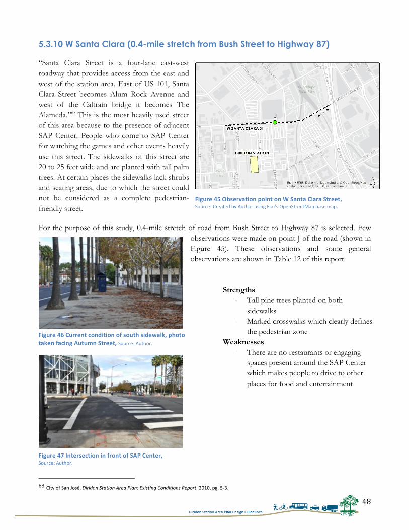
48
5.3.10 W Santa Clara (0.4-mile stretch from Bush Street to Highway 87) “Santa Clara Street is a four-lane east-west roadway that provides access from the east and west of the station area. East of US 101, Santa Clara Street becomes Alum Rock Avenue and west of the Caltrain bridge it becomes The Alameda.”68 This is the most heavily used street of this area because to the presence of adjacent SAP Center. People who come to SAP Center for watching the games and other events heavily use this street. The sidewalks of this street are 20 to 25 feet wide and are planted with tall palm trees. At certain places the sidewalks lack shrubs and seating areas, due to which the street could not be considered as a complete pedestrian-friendly street.
For the purpose of this study, 0.4-mile stretch of road from Bush Street to Highway 87 is selected. Few observations were made on point J of the road (shown in Figure 45). These observations and some general observations are shown in Table 12 of this report.
68 City of San José, Diridon Station Area Plan: Existing Conditions Report, 2010, pg. 5-‐3.
Strengths - Tall pine trees planted on both
sidewalks - Marked crosswalks which clearly defines
the pedestrian zone Weaknesses
- There are no restaurants or engaging spaces present around the SAP Center which makes people to drive to other places for food and entertainment
Figure 45 Observation point on W Santa Clara Street, Source: Created by Author using Esri’s OpenStreetMap base map.
Figure 46 Current condition of south sidewalk, photo taken facing Autumn Street, Source: Author.
Figure 47 Intersection in front of SAP Center, Source: Author.
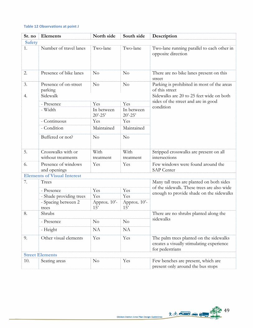
49
Table 12 Observations at point J
Sr. no Elements North side South side Description Safety 1. Number of travel lanes Two-lane Two-lane Two-lane running parallel to each other in
opposite direction
2. Presence of bike lanes No No There are no bike lanes present on this street
3. Presence of on-street parking
No No Parking is prohibited in most of the areas of this street
4. Sidewalk Sidewalks are 20 to 25 feet wide on both sides of the street and are in good condition
- Presence Yes Yes - Width In between
20’-25’ In between 20’-25’
- Continuous Yes Yes - Condition Maintained Maintained
Buffered or not? No No
5. Crosswalks with or without treatments
With treatment
With treatment
Stripped crosswalks are present on all intersections
6. Presence of windows and openings
Yes Yes Few windows were found around the SAP Center
Elements of Visual Interest 7. Trees Many tall trees are planted on both sides
of the sidewalk. These trees are also wide enough to provide shade on the sidewalks - Presence Yes Yes
- Shade providing trees Yes Yes - Spacing between 2 trees
Approx. 10’-15’
Approx. 10’-15’
8. Shrubs There are no shrubs planted along the sidewalks - Presence No No
- Height NA NA
9. Other visual elements Yes Yes The palm trees planted on the sidewalks creates a visually stimulating experience for pedestrians
Street Elements 10. Seating areas No Yes Few benches are present, which are
present only around the bus stops
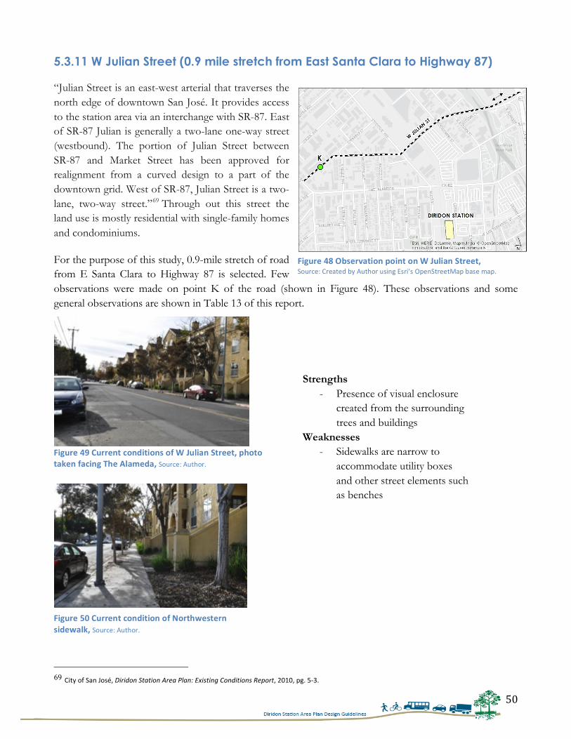
50
5.3.11 W Julian Street (0.9 mile stretch from East Santa Clara to Highway 87) “Julian Street is an east-west arterial that traverses the north edge of downtown San José. It provides access to the station area via an interchange with SR-87. East of SR-87 Julian is generally a two-lane one-way street (westbound). The portion of Julian Street between SR-87 and Market Street has been approved for realignment from a curved design to a part of the downtown grid. West of SR-87, Julian Street is a two-lane, two-way street.”69 Through out this street the land use is mostly residential with single-family homes and condominiums.
For the purpose of this study, 0.9-mile stretch of road from E Santa Clara to Highway 87 is selected. Few observations were made on point K of the road (shown in Figure 48). These observations and some general observations are shown in Table 13 of this report.
69 City of San José, Diridon Station Area Plan: Existing Conditions Report, 2010, pg. 5-‐3.
Strengths - Presence of visual enclosure
created from the surrounding trees and buildings
Weaknesses - Sidewalks are narrow to
accommodate utility boxes and other street elements such as benches
Figure 48 Observation point on W Julian Street, Source: Created by Author using Esri’s OpenStreetMap base map.
Figure 49 Current conditions of W Julian Street, photo taken facing The Alameda, Source: Author.
Figure 50 Current condition of Northwestern sidewalk, Source: Author.
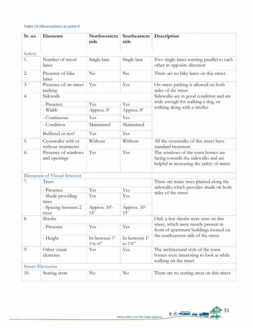
51
Table 13 Observations at point K
Sr. no Elements Northwestern side
Southeastern side
Description
Safety 1. Number of travel
lanes Single lane Single lane Two single-lanes running parallel to each
other in opposite direction
2. Presence of bike lanes
No No There are no bike lanes on this street
3. Presence of on-street parking
Yes Yes On street parking is allowed on both sides of the street
4. Sidewalk Sidewalks are in good condition and are wide enough for walking a dog, or walking along with a stroller
- Presence Yes Yes - Width Approx. 8’ Approx. 8’
- Continuous Yes Yes - Condition Maintained Maintained
Buffered or not? Yes Yes
5. Crosswalks with or without treatments
Without Without All the crosswalks of this street have standard treatment
6. Presence of windows and openings
Yes Yes The windows of the town homes are facing towards the sidewalks and are helpful in increasing the safety of street
Elements of Visual Interest 7. Trees There are many trees planted along the
sidewalks which provides shade on both sides of the street - Presence Yes Yes
- Shade providing trees
Yes Yes
- Spacing between 2 trees
Approx. 10’-15’
Approx. 10’-15’
8. Shrubs Only a few shrubs were seen on this street, which were mostly present in front of apartment buildings located on the southeastern side of the street
- Presence Yes
Yes
- Height In between 1’-1’to 6”
In between 1’ to 1’6”
9. Other visual elements
Yes Yes The architectural style of the town homes were interesting to look at while walking on the street
Street Elements 10. Seating areas No No There are no seating areas on this street
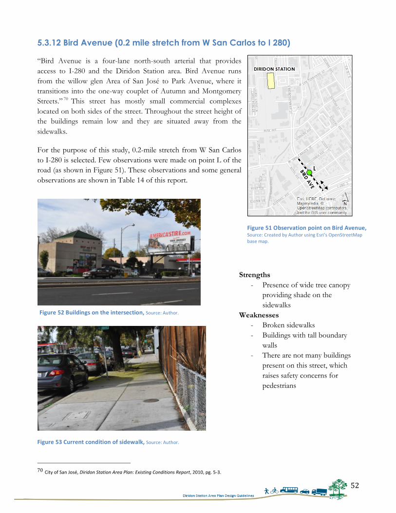
52
5.3.12 Bird Avenue (0.2 mile stretch from W San Carlos to I 280) “Bird Avenue is a four-lane north-south arterial that provides access to I-280 and the Diridon Station area. Bird Avenue runs from the willow glen Area of San José to Park Avenue, where it transitions into the one-way couplet of Autumn and Montgomery Streets.” 70 This street has mostly small commercial complexes located on both sides of the street. Throughout the street height of the buildings remain low and they are situated away from the sidewalks.
For the purpose of this study, 0.2-mile stretch from W San Carlos to I-280 is selected. Few observations were made on point L of the road (as shown in Figure 51). These observations and some general observations are shown in Table 14 of this report.
70 City of San José, Diridon Station Area Plan: Existing Conditions Report, 2010, pg. 5-‐3.
Strengths - Presence of wide tree canopy
providing shade on the sidewalks
Weaknesses - Broken sidewalks - Buildings with tall boundary
walls - There are not many buildings
present on this street, which raises safety concerns for pedestrians
Figure 51 Observation point on Bird Avenue, Source: Created by Author using Esri’s OpenStreetMap base map.
Figure 52 Buildings on the intersection, Source: Author.
Figure 53 Current condition of sidewalk, Source: Author.
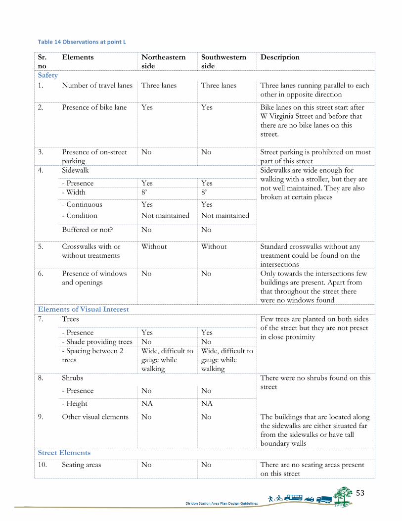
53
Table 14 Observations at point L
Sr. no
Elements Northeastern side
Southwestern side
Description
Safety 1. Number of travel lanes Three lanes Three lanes Three lanes running parallel to each
other in opposite direction
2. Presence of bike lane Yes Yes Bike lanes on this street start after W Virginia Street and before that there are no bike lanes on this street.
3. Presence of on-street parking
No No Street parking is prohibited on most part of this street
4. Sidewalk Sidewalks are wide enough for walking with a stroller, but they are not well maintained. They are also broken at certain places
- Presence Yes Yes - Width 8’ 8’
- Continuous Yes Yes - Condition Not maintained Not maintained
Buffered or not? No No
5. Crosswalks with or without treatments
Without Without Standard crosswalks without any treatment could be found on the intersections
6. Presence of windows and openings
No No Only towards the intersections few buildings are present. Apart from that throughout the street there were no windows found
Elements of Visual Interest 7. Trees Few trees are planted on both sides
of the street but they are not preset in close proximity - Presence Yes Yes
- Shade providing trees No No - Spacing between 2 trees
Wide, difficult to gauge while walking
Wide, difficult to gauge while walking
8. Shrubs There were no shrubs found on this street - Presence No No
- Height NA NA
9. Other visual elements No No The buildings that are located along the sidewalks are either situated far from the sidewalks or have tall boundary walls
Street Elements
10. Seating areas No No There are no seating areas present on this street
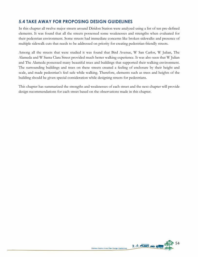
54
5.4 TAKE AWAY FOR PROPOSING DESIGN GUIDELINES In this chapter all twelve major streets around Diridon Station were analyzed using a list of ten pre-defined elements. It was found that all the streets possessed some weaknesses and strengths when evaluated for their pedestrian environment. Some streets had immediate concerns like broken sidewalks and presence of multiple sidewalk cuts that needs to be addressed on priority for creating pedestrian-friendly streets.
Among all the streets that were studied it was found that Bird Avenue, W San Carlos, W Julian, The Alameda and W Santa Clara Street provided much better walking experience. It was also seen that W Julian and The Alameda possessed many beautiful trees and buildings that supported their walking environment. The surrounding buildings and trees on these streets created a feeling of enclosure by their height and scale, and made pedestrian’s feel safe while walking. Therefore, elements such as trees and heights of the building should be given special consideration while designing streets for pedestrians.
This chapter has summarized the strengths and weaknesses of each street and the next chapter will provide design recommendations for each street based on the observations made in this chapter.
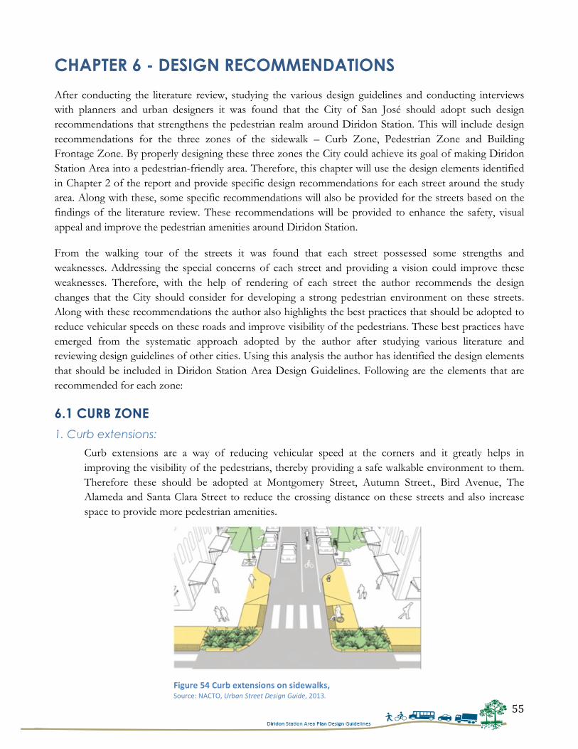
55
CHAPTER 6 - DESIGN RECOMMENDATIONS After conducting the literature review, studying the various design guidelines and conducting interviews with planners and urban designers it was found that the City of San José should adopt such design recommendations that strengthens the pedestrian realm around Diridon Station. This will include design recommendations for the three zones of the sidewalk – Curb Zone, Pedestrian Zone and Building Frontage Zone. By properly designing these three zones the City could achieve its goal of making Diridon Station Area into a pedestrian-friendly area. Therefore, this chapter will use the design elements identified in Chapter 2 of the report and provide specific design recommendations for each street around the study area. Along with these, some specific recommendations will also be provided for the streets based on the findings of the literature review. These recommendations will be provided to enhance the safety, visual appeal and improve the pedestrian amenities around Diridon Station.
From the walking tour of the streets it was found that each street possessed some strengths and weaknesses. Addressing the special concerns of each street and providing a vision could improve these weaknesses. Therefore, with the help of rendering of each street the author recommends the design changes that the City should consider for developing a strong pedestrian environment on these streets. Along with these recommendations the author also highlights the best practices that should be adopted to reduce vehicular speeds on these roads and improve visibility of the pedestrians. These best practices have emerged from the systematic approach adopted by the author after studying various literature and reviewing design guidelines of other cities. Using this analysis the author has identified the design elements that should be included in Diridon Station Area Design Guidelines. Following are the elements that are recommended for each zone:
6.1 CURB ZONE
1. Curb extensions:
Curb extensions are a way of reducing vehicular speed at the corners and it greatly helps in improving the visibility of the pedestrians, thereby providing a safe walkable environment to them. Therefore these should be adopted at Montgomery Street, Autumn Street., Bird Avenue, The Alameda and Santa Clara Street to reduce the crossing distance on these streets and also increase space to provide more pedestrian amenities.
Figure 54 Curb extensions on sidewalks, Source: NACTO, Urban Street Design Guide, 2013.
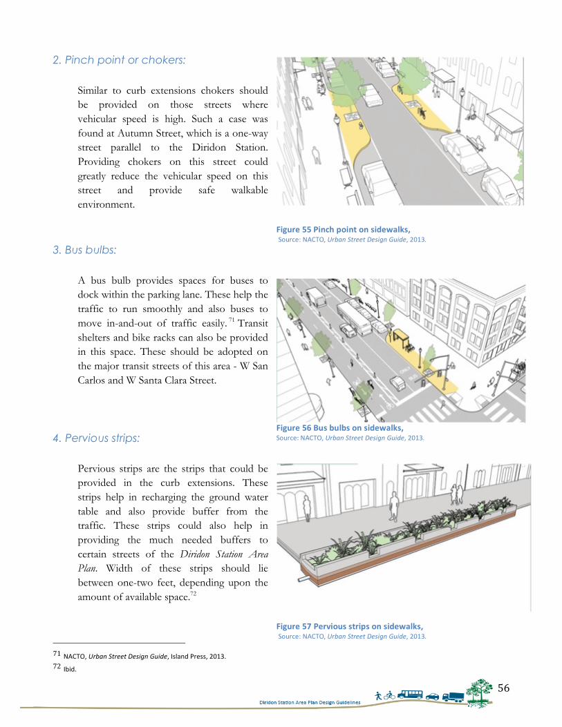
56
2. Pinch point or chokers:
Similar to curb extensions chokers should be provided on those streets where vehicular speed is high. Such a case was found at Autumn Street, which is a one-way street parallel to the Diridon Station. Providing chokers on this street could greatly reduce the vehicular speed on this street and provide safe walkable environment.
3. Bus bulbs:
A bus bulb provides spaces for buses to dock within the parking lane. These help the traffic to run smoothly and also buses to move in-and-out of traffic easily. 71 Transit shelters and bike racks can also be provided in this space. These should be adopted on the major transit streets of this area - W San Carlos and W Santa Clara Street.
4. Pervious strips:
Pervious strips are the strips that could be provided in the curb extensions. These strips help in recharging the ground water table and also provide buffer from the traffic. These strips could also help in providing the much needed buffers to certain streets of the Diridon Station Area Plan. Width of these strips should lie between one-two feet, depending upon the amount of available space.72
71 NACTO, Urban Street Design Guide, Island Press, 2013. 72 Ibid.
Figure 55 Pinch point on sidewalks, Source: NACTO, Urban Street Design Guide, 2013.
Figure 56 Bus bulbs on sidewalks, Source: NACTO, Urban Street Design Guide, 2013.
Figure 57 Pervious strips on sidewalks, Source: NACTO, Urban Street Design Guide, 2013.
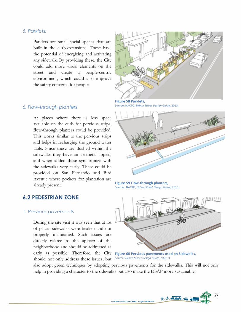
57
5. Parklets:
Parklets are small social spaces that are built in the curb-extensions. These have the potential of energizing and activating any sidewalk. By providing these, the City could add more visual elements on the street and create a people-centric environment, which could also improve the safety concerns for people.
6. Flow-through planters At places where there is less space available on the curb for pervious strips, flow-through planters could be provided. This works similar to the pervious strips and helps in recharging the ground water table. Since these are flushed within the sidewalks they have an aesthetic appeal, and when added these synchronize with the sidewalks very easily. These could be provided on San Fernando and Bird Avenue where pockets for plantation are already present.
6.2 PEDESTRIAN ZONE 1. Pervious pavements
During the site visit it was seen that at lot of places sidewalks were broken and not properly maintained. Such issues are directly related to the upkeep of the neighborhood and should be addressed as early as possible. Therefore, the City should not only address these issues, but also adopt green techniques by adopting pervious pavements for the sidewalks. This will not only help in providing a character to the sidewalks but also make the DSAP more sustainable.
Figure 58 Parklets, Source: NACTO, Urban Street Design Guide, 2013.
Figure 59 Flow-‐through planters, Source: NACTO, Urban Street Design Guide, 2013.
Figure 60 Pervious pavements used on Sidewalks, Source: Urban Street Design Guide, NACTO.
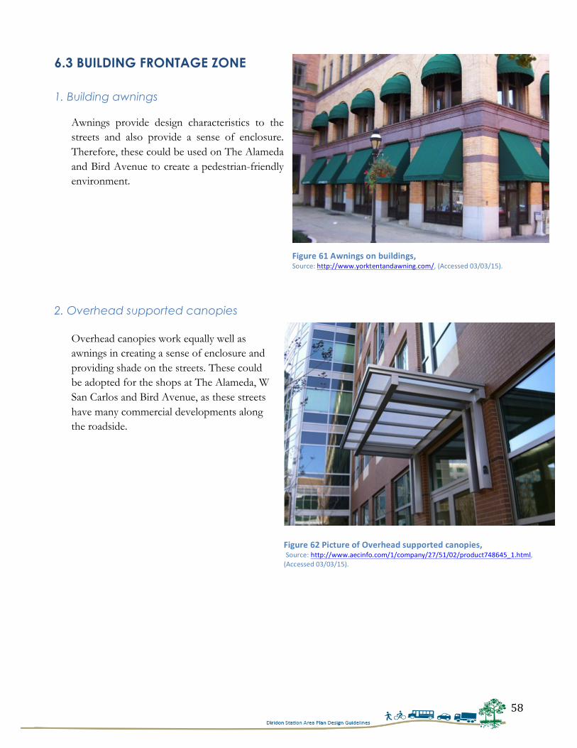
58
6.3 BUILDING FRONTAGE ZONE 1. Building awnings
Awnings provide design characteristics to the streets and also provide a sense of enclosure. Therefore, these could be used on The Alameda and Bird Avenue to create a pedestrian-friendly environment.
2. Overhead supported canopies
Overhead canopies work equally well as awnings in creating a sense of enclosure and providing shade on the streets. These could be adopted for the shops at The Alameda, W San Carlos and Bird Avenue, as these streets have many commercial developments along the roadside.
Figure 61 Awnings on buildings, Source: http://www.yorktentandawning.com/, (Accessed 03/03/15).
Figure 62 Picture of Overhead supported canopies, Source: http://www.aecinfo.com/1/company/27/51/02/product748645_1.html, (Accessed 03/03/15).
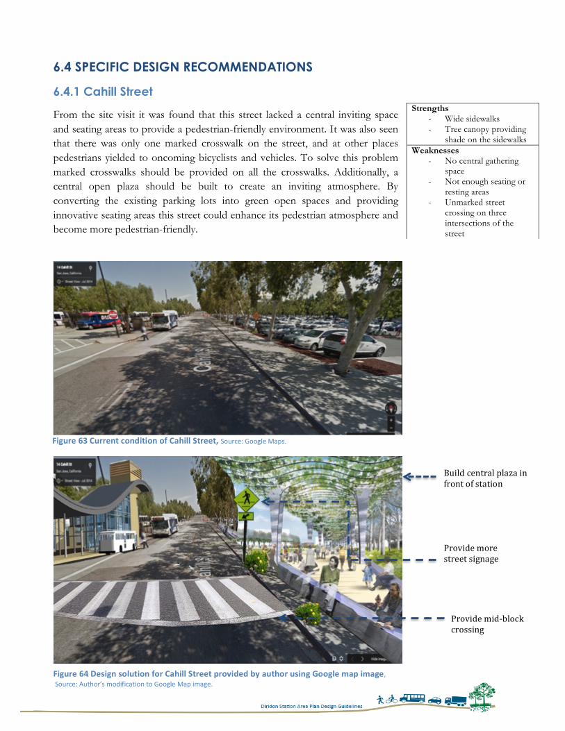
59
6.4 SPECIFIC DESIGN RECOMMENDATIONS
6.4.1 Cahill Street
From the site visit it was found that this street lacked a central inviting space and seating areas to provide a pedestrian-friendly environment. It was also seen that there was only one marked crosswalk on the street, and at other places pedestrians yielded to oncoming bicyclists and vehicles. To solve this problem marked crosswalks should be provided on all the crosswalks. Additionally, a central open plaza should be built to create an inviting atmosphere. By converting the existing parking lots into green open spaces and providing innovative seating areas this street could enhance its pedestrian atmosphere and become more pedestrian-friendly.
Strengths - Wide sidewalks - Tree canopy providing
shade on the sidewalks Weaknesses
- No central gathering space
- Not enough seating or resting areas
- Unmarked street crossing on three intersections of the street
Figure 63 Current condition of Cahill Street, Source: Google Maps.
Figure 64 Design solution for Cahill Street provided by author using Google map image, Source: Author’s modification to Google Map image.
Build central plaza in front of station
Provide mid-‐block crossing
Provide more street signage
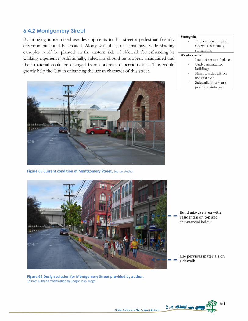
60
6.4.2 Montgomery Street
By bringing more mixed-use developments to this street a pedestrian-friendly environment could be created. Along with this, trees that have wide shading canopies could be planted on the eastern side of sidewalk for enhancing its walking experience. Additionally, sidewalks should be properly maintained and their material could be changed from concrete to pervious tiles. This would greatly help the City in enhancing the urban character of this street.
Strengths - Tree canopy on west
sidewalk is visually stimulating
Weaknesses - Lack of sense of place - Under maintained
buildings - Narrow sidewalk on
the east side - Sidewalk shrubs are
poorly maintained
Figure 65 Current condition of Montgomery Street, Source: Author.
Figure 66 Design solution for Montgomery Street provided by author, Source: Author's modification to Google Map image.
Build mix-‐use area with residential on top and commercial below
Use pervious materials on sidewalk
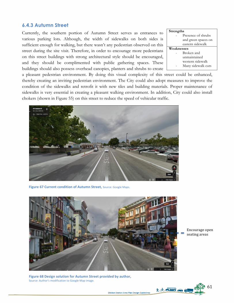
61
6.4.3 Autumn Street Currently, the southern portion of Autumn Street serves as entrances to various parking lots. Although, the width of sidewalks on both sides is sufficient enough for walking, but there wasn’t any pedestrian observed on this street during the site visit. Therefore, in order to encourage more pedestrians on this street buildings with strong architectural style should be encouraged, and they should be complimented with public gathering spaces. These buildings should also possess overhead canopies, planters and shrubs to create a pleasant pedestrian environment. By doing this visual complexity of this street could be enhanced, thereby creating an inviting pedestrian environment. The City could also adopt measures to improve the condition of the sidewalks and retrofit it with new tiles and building materials. Proper maintenance of sidewalks is very essential in creating a pleasant walking environment. In addition, City could also install chokers (shown in Figure 55) on this street to reduce the speed of vehicular traffic.
Strengths - Presence of shrubs
and green spaces on eastern sidewalk
Weaknesses - Broken and
unmaintained western sidewalk
- Many sidewalk cuts
Figure 67 Current condition of Autumn Street, Source: Google Maps.
Figure 68 Design solution for Autumn Street provided by author, Source: Author's modification to Google Map image.
Encourage open seating areas
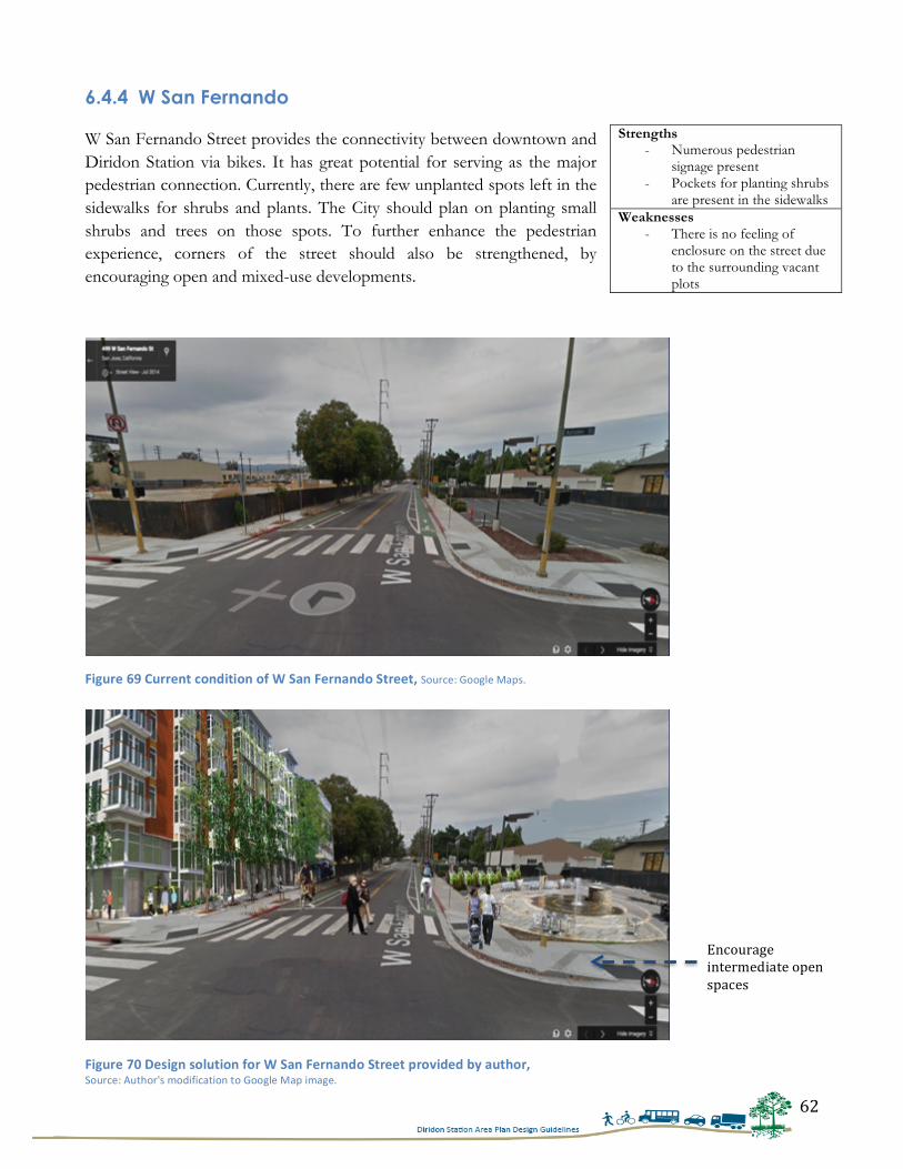
62
6.4.4 W San Fernando W San Fernando Street provides the connectivity between downtown and Diridon Station via bikes. It has great potential for serving as the major pedestrian connection. Currently, there are few unplanted spots left in the sidewalks for shrubs and plants. The City should plan on planting small shrubs and trees on those spots. To further enhance the pedestrian experience, corners of the street should also be strengthened, by encouraging open and mixed-use developments.
Strengths - Numerous pedestrian
signage present - Pockets for planting shrubs
are present in the sidewalks Weaknesses
- There is no feeling of enclosure on the street due to the surrounding vacant plots
Figure 69 Current condition of W San Fernando Street, Source: Google Maps.
Figure 70 Design solution for W San Fernando Street provided by author, Source: Author's modification to Google Map image.
Encourage intermediate open spaces
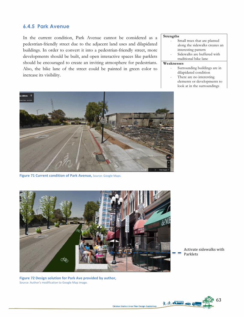
63
6.4.5 Park Avenue In the current condition, Park Avenue cannot be considered as a pedestrian-friendly street due to the adjacent land uses and dilapidated buildings. In order to convert it into a pedestrian-friendly street, more developments should be built, and open interactive spaces like parklets should be encouraged to create an inviting atmosphere for pedestrians. Also, the bike lane of the street could be painted in green color to increase its visibility.
Strengths - Small trees that are planted
along the sidewalks creates an interesting pattern
- Sidewalks are buffered with traditional bike lane
Weaknesses - Surrounding buildings are in
dilapidated condition - There are no interesting
elements or developments to look at in the surroundings
Figure 71 Current condition of Park Avenue, Source: Google Maps.
Figure 72 Design solution for Park Ave provided by author, Source: Author's modification to Google Map image.
Activate sidewalks with Parklets
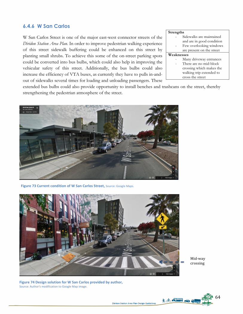
64
6.4.6 W San Carlos W San Carlos Street is one of the major east-west connector streets of the Diridon Station Area Plan. In order to improve pedestrian walking experience of this street sidewalk buffering could be enhanced on this street by planting small shrubs. To achieve this some of the on-street parking spots could be converted into bus bulbs, which could also help in improving the vehicular safety of this street. Additionally, the bus bulbs could also increase the efficiency of VTA buses, as currently they have to pulls in-and-out of sidewalks several times for loading and unloading passengers. These extended bus bulbs could also provide opportunity to install benches and trashcans on the street, thereby strengthening the pedestrian atmosphere of the street.
Strengths - Sidewalks are maintained
and are in good condition - Few overlooking windows
are present on the street Weaknesses
- Many driveway entrances - There are no mid-block
crossing which makes the walking trip extended to cross the street
Figure 73 Current condition of W San Carlos Street, Source: Google Maps.
Figure 74 Design solution for W San Carlos provided by author, Source: Author's modification to Google Map image.
Mid-‐way crossing
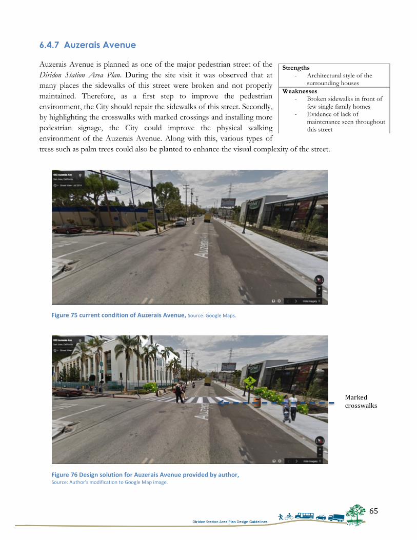
65
6.4.7 Auzerais Avenue Auzerais Avenue is planned as one of the major pedestrian street of the Diridon Station Area Plan. During the site visit it was observed that at many places the sidewalks of this street were broken and not properly maintained. Therefore, as a first step to improve the pedestrian environment, the City should repair the sidewalks of this street. Secondly, by highlighting the crosswalks with marked crossings and installing more pedestrian signage, the City could improve the physical walking environment of the Auzerais Avenue. Along with this, various types of tress such as palm trees could also be planted to enhance the visual complexity of the street.
Strengths - Architectural style of the
surrounding houses Weaknesses
- Broken sidewalks in front of few single family homes
- Evidence of lack of maintenance seen throughout this street
Figure 75 current condition of Auzerais Avenue, Source: Google Maps.
Figure 76 Design solution for Auzerais Avenue provided by author, Source: Author's modification to Google Map image.
Marked crosswalks
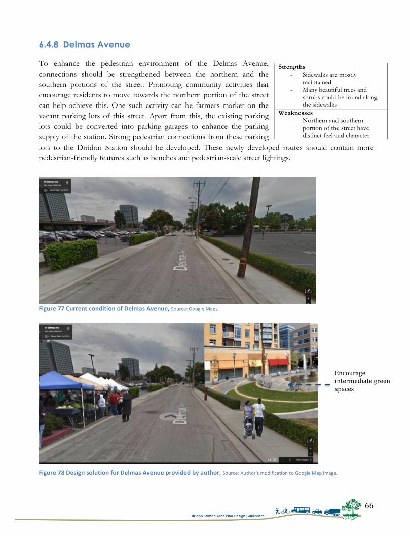
66
6.4.8 Delmas Avenue To enhance the pedestrian environment of the Delmas Avenue, connections should be strengthened between the northern and the southern portions of the street. Promoting community activities that encourage residents to move towards the northern portion of the street can help achieve this. One such activity can be farmers market on the vacant parking lots of this street. Apart from this, the existing parking lots could be converted into parking garages to enhance the parking supply of the station. Strong pedestrian connections from these parking lots to the Diridon Station should be developed. These newly developed routes should contain more pedestrian-friendly features such as benches and pedestrian-scale street lightings.
Strengths - Sidewalks are mostly
maintained - Many beautiful trees and
shrubs could be found along the sidewalks
Weaknesses - Northern and southern
portion of the street have distinct feel and character
Figure 77 Current condition of Delmas Avenue, Source: Google Maps.
Figure 78 Design solution for Delmas Avenue provided by author, Source: Author's modification to Google Map image.
Encourage intermediate green spaces
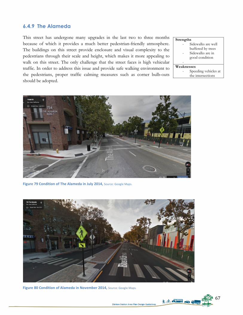
67
6.4.9 The Alameda This street has undergone many upgrades in the last two to three months because of which it provides a much better pedestrian-friendly atmosphere. The buildings on this street provide enclosure and visual complexity to the pedestrians through their scale and height, which makes it more appealing to walk on this street. The only challenge that the street faces is high vehicular traffic. In order to address this issue and provide safe walking environment to the pedestrians, proper traffic calming measures such as corner bulb-outs should be adopted.
Strengths - Sidewalks are well
buffered by trees - Sidewalks are in
good condition -
Weaknesses - Speeding vehicles at
the intersections
Figure 79 Condition of The Alameda in July 2014, Source: Google Maps.
Figure 80 Condition of Alameda in November 2014, Source: Google Maps.
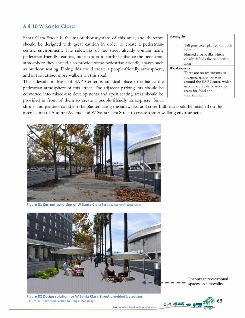
68
6.4.10 W Santa Clara Santa Clara Street is the major thoroughfare of this area, and therefore should be designed with great caution in order to create a pedestrian-centric environment. The sidewalks of the street already contain many pedestrian-friendly features, but in order to further enhance the pedestrian atmosphere they should also provide some pedestrian-friendly spaces such as outdoor seating. Doing this could create a people-friendly atmosphere, and in turn attract more walkers on this road. The sidewalk in front of SAP Center is an ideal place to enhance the pedestrian atmosphere of this street. The adjacent parking lots should be converted into mixed-use developments and open seating areas should be provided in front of them to create a people-friendly atmosphere. Small shrubs and planters could also be planted along the sidewalks, and corer bulb-out could be installed on the intersection of Autumn Avenue and W Santa Clara Street to create a safer walking environment.
Strengths
- Tall pine trees planted on both sides
- Marked crosswalks which clearly defines the pedestrian zone
Weaknesses - There are no restaurants or
engaging spaces present around the SAP Center, which makes people drive to other areas for food and entertainment
Figure 81 Current condition of W Santa Clara Street, Source: Google Maps.
Figure 82 Design solution for W Santa Clara Street provided by author, Source: Author's modification to Google Map image.
Encourage recreational spaces on sidewalks
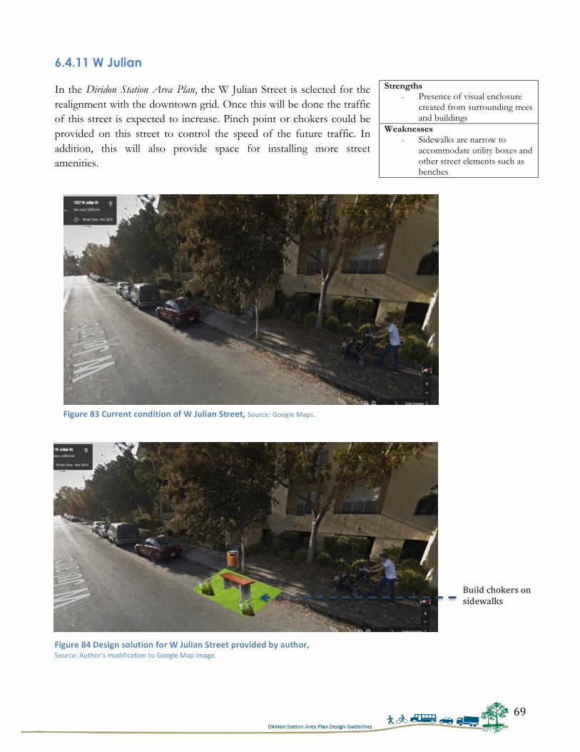
69
6.4.11 W Julian In the Diridon Station Area Plan, the W Julian Street is selected for the realignment with the downtown grid. Once this will be done the traffic of this street is expected to increase. Pinch point or chokers could be provided on this street to control the speed of the future traffic. In addition, this will also provide space for installing more street amenities.
Strengths - Presence of visual enclosure
created from surrounding trees and buildings
Weaknesses - Sidewalks are narrow to
accommodate utility boxes and other street elements such as benches
Build chokers on sidewalks
Figure 83 Current condition of W Julian Street, Source: Google Maps.
Figure 84 Design solution for W Julian Street provided by author, Source: Author's modification to Google Map image.
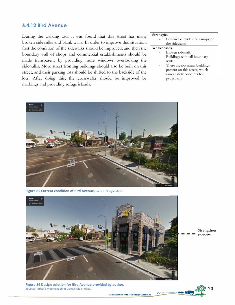
70
6.4.12 Bird Avenue During the walking tour it was found that this street has many broken sidewalks and blank walls. In order to improve this situation, first the condition of the sidewalks should be improved, and then the boundary wall of shops and commercial establishments should be made transparent by providing more windows overlooking the sidewalks. More street fronting buildings should also be built on this street, and their parking lots should be shifted to the backside of the lots. After doing this, the crosswalks should be improved by markings and providing refuge islands.
Strengths - Presence of wide tree canopy on
the sidewalks Weaknesses
- Broken sidewalk - Buildings with tall boundary
walls - There are not many buildings
present on this street, which raises safety concerns for pedestrians
Figure 85 Current condition of Bird Avenue, Source: Google Maps.
Figure 86 Design solution for Bird Avenue provided by author, Source: Author's modification of Google Map image.
Strengthen corners
71
6.5 CONCLUSION This study explored the ways by which streets around a transit station could be made pedestrian-friendly. Here the case study selected was of San José, California. The study’s findings reveal that the presence of pedestrian amenities, presence of safety on streets, and elements of visual interest play an important role in encouraging more pedestrian activities on the streets. These elements could be incorporated into streets by properly designing all the three zones of sidewalks. Therefore, the City of San José should develop design guidelines based on these three zones for the Diridon Station Area Plan.
The first set of conclusions refers to the elements that are required to be included for the three major zones. With reference to the guidelines for Curb Zone, the city should include guidelines for corner curb radii, bus bulbs, chokers, parklets and plantation strips to reduce vehicular speeds and to provide more opportunities for installing pedestrian amenities. The guidelines for Pedestrian Zone should incorporate recommendations for the use of green and sustainable materials such as pervious strips. Moreover, the guidelines for Building Zone should possess elements that provide visual enclosure and complexity on the streets, such as canopies and awnings.
The second set of conclusions is drawn upon after an analysis of the built environment at the existing streets. After analyzing all the streets selected for this research, the study arrives at a mix results. It can be concluded that all the streets possess few strengths and weaknesses in their built environment. For the most part, the sidewalks of the streets were well maintained, with the exception of Autumn and Delmas Avenue. Although the sidewalks of other streets were well maintained, very few pedestrians were observed on those streets. This could be mainly due to the surrounding land use type existing on those streets. Most of the streets had vacant plots because of which they were found not conducive for walking. Therefore, the City of San José should conduct more analysis on these streets and develop ways by which enclosure through surrounding building and developments could be achieved on these streets.
Finally, the last set of conclusions pertains to the addition of character to the existing space. In order to do so it is recommended that the City should also convert the parking lots in front of Diridon Station into people-friendly spaces, such as open plaza and green space. The existing parking lots can be shifted to Delmas Ave, which is at a distance of 0.3 mile from Cahill Street. By doing this City would be able to provide a central green space in front of Diridon Station. More importantly, this would provide the much-needed character to this area, which currently it lacks due to the massive parking lots. This is anticipated to bring a significant difference to the surroundings of Diridon Station and would contribute in encouraging more pedestrian activities in this area.
72
BIBLIOGRAPHY Adkins, Arlie, et al. “Unpacking Walkability: Testing the influence of Urban Design Features on
Perceptions of Walking Environment Attractiveness.” Journal of Urban Design 17, no. 4 (2012): 499-510.
Addy, Cheryl, et al. “Associations of Perceived Social and Physical Environmental Supports With Physical
Activity and Walking Behavior.” American Journal of Public Health 94, no. 3 (2004): 440-443. Agrawal, Asha, Marc Schlossberg and Katja Irvin. “How Far, by Which Route and Why? A Spatial
Analysis of Pedestrian Preference.” Journal of Urban Design 13, no. 1 (2008): 81-98. Alfonzo, Mariela. “To Walk or Not to Walk? The Hierarchy of Walking Needs.” Environment and Behavior
37, no.6 (2005): 808-836. Alfonzo, Mariela, et al. “The Relationship of Neighborhood Built Environment Features and Adult
Parents’ Walking.” Journal of Urban Design 13, no. 1 (2008): 29-51. Ariffin, Raja, and Rustam khairi Zahari. “Perceptions of the Urban Walking Environments.” Procedia- Social
and Behavioral Sciences 105, no. 0 (2013): 589-597. Bahari, Noor, Ahmad Kamil Arshad and Zahrullaili Yahya. “Assessing the Pedestrians’ Perception of the
Sidewalk Facilities Based on Pedestrian Travel Purpose.” IEEE 9th International Colloquium on Signal Processing and its Applications (2013): 27-32.
Borst, Hieronymus, et al. “Relationships Between Street Characteristics and Perceived Attractiveness for
Walking Reported by Elderly People.” Journal of Environmental Psychology 28, no.0 (2008): 353-361. Brown, Barbara, et al. “Walkable Route Perceptions and Physical Features: Converging Evidence for En
Route Walking Experiences.” Environment and Behavior 39, no.1 (2006): 34-61. Cain, Kelli, et al. “Contribution of Streetscape audits to Explanation of Physical Activity in Four Age
Groups Based on the Microscale Audits of Pedestrian Streetscapes (MAPS).” Social Science and Medicine 116, no.0 (2014): 82-92.
Cauwenberg, Jelle, et al. “Relationships Between the Perceived Neighborhood Social Environment and
Walking for Transportation Among Older Adults.” Social Science and Medicine 104, no.0 (2014): 23-30.
Cauwenberg, Jelle, et al. “Physical Environmental Factors that Invite Older Adults to Walk for
Transportation.” Journal of Environmental Phycology 38, (2014): 94-103. City of Alameda. Pedestrian Design Guidelines, Alameda, California, 2011. City of San Francisco. Better Streets Plan, San Francisco, California, 2010. City of San José. Diridon Station Area Plan: Final Plan Report, San José, California, 2014.
73
City of San José. Diridon Station Area Plan: Existing Conditions Report, San José, California, 2010. City of San José. San José Downtown Streetscape Master Plan, San José, California, 2003. City of San José. North San José Urban Design Guidelines, San José, California, 2010. City of Minneapolis. Design Guidelines for Streets and Sidewalks, Minneapolis, Minnesota, 2009. City of Portland. Portland Pedestrian Street Design Guide. Office of Transportation Engineering and
Development, Portland, Oregon, 1998. Dandan, Tan, et al. “Research on Methods of Accessing Pedestrian Level of Service for Sidewalks.” Journal
of Transportation Systems Engineering and Information Technology 7, no.5 (2007): 74-79. Ewing, Reid, and Susan Handy. “Measuring the Unmeasurable: Urban Design Qualities Related to
Walkability: Urban Design Qualities Related to Walkability.” Journal of Urban Design 14:1, (2009): 65-84.
Gomez, Luis, et al. “Built Environment Attributes and Walking Patterns Among the Elderly Population in
Bogotá.” American Journal of Preventive Medicine 38, no. 6 (2010): 592-599. Haans, Antal, and Yvonne A.W. de Kort. “Light Distribution in Dynamic Street Lighting: Two
Experimental Studies on its Effects on Perceived Safety, Prospect, Concealment and Escape.” Journal of Environmental Psychology 32, (2012): 342-352.
Hammond, Victoria and Charles Musselwhite. “The Attitudes, Perceptions, and Concerns of Pedestrians
and Vulnerable Road Users to Shared Space: A Case Study from the UK.” Journal of Urban Design 18, no. 1 (2003): 78-97.
Hosseini, Sayed, Saeid Norouzian Maleki and Amirreza Karimi Azari. “The Influences of Access
Improvements in Pedestrian Street Use.” Procedia- Social Behavioral Sciences 35, (2012): 645-651. Kaparias, Ionnis, et al. “Analysing the Perceptions of Pedestrians and Drivers to Shared Space.”
Transportation Research Part F 15, no. 3 (2012): 297-310. Kang, Lei, Yingge Xiong, and Fred L. Mannering. “Statistical Analysis of Pedestrian Perceptions of
Sidewalk Level of Service in the Presence of Bicycles.” Transportation Research Part A 53, no.0 (2013): 10-21.
Kelly, et al. “A Comparison of Three Methods for Accessing the Walkability of the Pedestrian
Environment.” Journal of Transport Geography 19, no. 41 (2011): 1500-1508. Kim, Saehoon, Sungjin Park and Jae Seung Lee. “Meso-or-Micro–Scale? Environmental Factors
Influencing Pedestrian Satisfaction.” Transportation Research Part D 30, (2014): 10-20. Lee, Byung, et al. “Design Criteria for an Urban Sidewalk Landscape Considering Emotional Perception.”
Journal of Urban Planning and Development 135, no.4 (2009): 133-140. Mehta, Vikas. “Walkable Streets: Pedestrians Behavior, Perceptions and Attitudes.” Journal of Urbanism:
International Research on Placemaking and Urban Sustainability, 1:3, (2008): 217-245.
74
Michael, Yvonne, Mandy K. Green, and Stephanie A. Farquhar. “Neighborhood Design and Active
Aging.” Health & Place 12, no. 0 (2006): 734-740. Monteiro, Fernanda, et al. “A Proposal of Indicators for Evaluation of the Urban Pedestrians and Cyclists
in Access to Mass Transit Station.” Procedia- Social and Behavioral Sciences 54, no.0 (2012): 637-645. National Association of City Transportation Officials. Urban Street Design Guide, Island Press, 2013. Oregon Department of Transportation. Bicycle and Pedestrian Design Guide 3rd Edition, Oregon, 2011. Rosenberg, Dori, et al. “Outdoor Built Environment Barriers and Facilitators to Activity among Midlife
and Older Adults with Mobility Disabilities.” The Gerontologist 53, no. 2 (2012): 268-279. Rodriguez, Daniel, Elizabeth M. Brisson and Nicolas Estupinan. “The Relationship Between Segment-
Level Built Environment Attributes and Pedestrian Activity Around Bogota’s BRTS Stations.” Transportation Research Part D 14, no.7 (2009): 470-478.
Sisiopiku, V. P. and D. Akin. “Pedestrian Behaviors at and Perceptions Towards Various Pedestrian
Facilities: An Examination Based on Observation and Survey Data.” Transportation Research Part F 6, no. 4 (2003): 249-274.
Villaveces, Andres, et al. “Pedestrians’ Perceptions of Walkability and Safety in Relation to the Built
Environment in Cali, Columbia.” Injury Prevention 18, (2012): 291-297. Wang, Weijie, Byungjoo Lee and Moon Namgung. “Extracting Features of Sidewalk Space Using the
Rough Sets Approach.” Environment and Planning B: Planning and Design 35, no.5 (2008): 920-934.
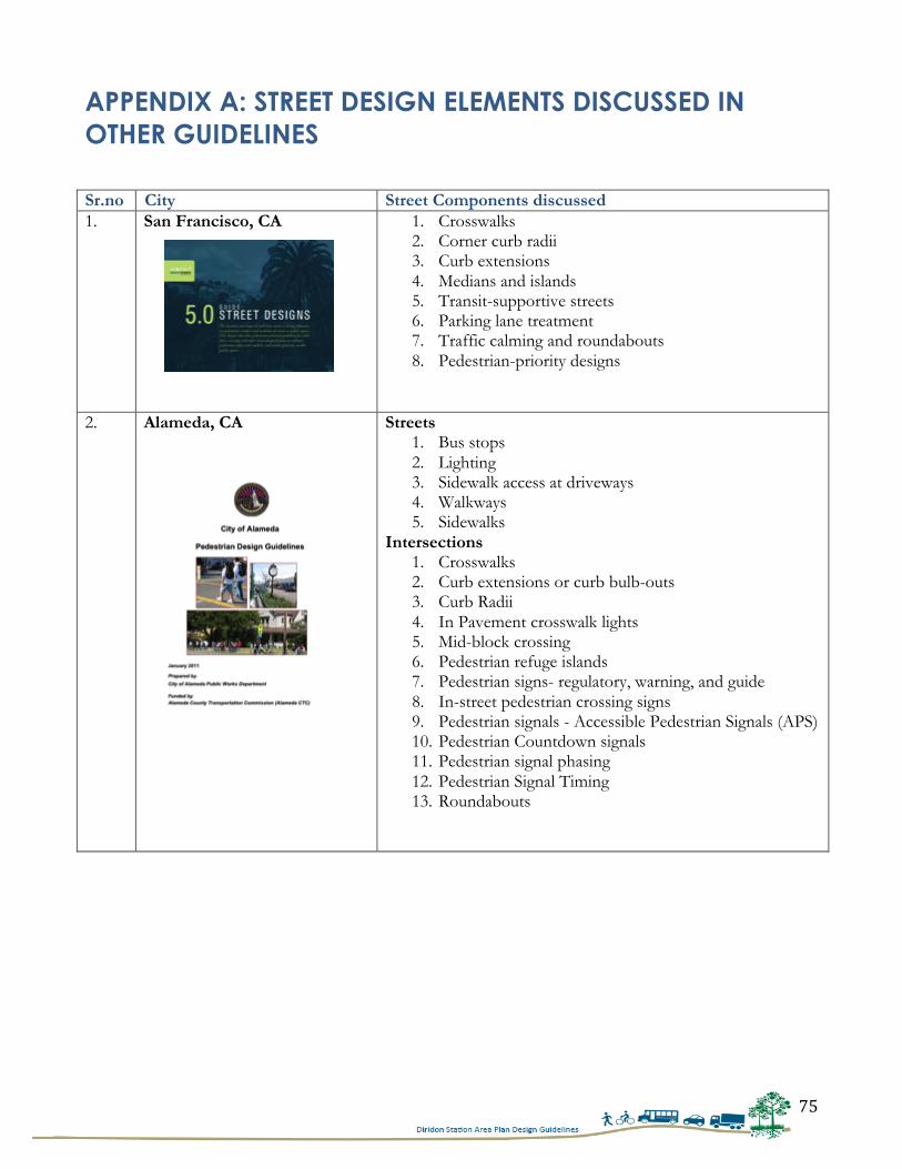
75
APPENDIX A: STREET DESIGN ELEMENTS DISCUSSED IN OTHER GUIDELINES Sr.no City Street Components discussed 1. San Francisco, CA
1. Crosswalks 2. Corner curb radii 3. Curb extensions 4. Medians and islands 5. Transit-supportive streets 6. Parking lane treatment 7. Traffic calming and roundabouts 8. Pedestrian-priority designs
2. Alameda, CA
Streets 1. Bus stops 2. Lighting 3. Sidewalk access at driveways 4. Walkways 5. Sidewalks
Intersections 1. Crosswalks 2. Curb extensions or curb bulb-outs 3. Curb Radii 4. In Pavement crosswalk lights 5. Mid-block crossing 6. Pedestrian refuge islands 7. Pedestrian signs- regulatory, warning, and guide 8. In-street pedestrian crossing signs 9. Pedestrian signals - Accessible Pedestrian Signals (APS) 10. Pedestrian Countdown signals 11. Pedestrian signal phasing 12. Pedestrian Signal Timing 13. Roundabouts
76
3. State of Oregon
Walkways 1. Walkways types 2. Sidewalks
- Curb zone - Furniture zone - Pedestrian zone - Frontage zone
3. Sidewalks without curb and gutter - Sidewalks behind the ditch
4. Other Pedestrian Facilities - Benches - Awnings - Shelters - Landscaping - Drinking water fountains and public restrooms
5. Other Considerations - Driveways - Alleys - Signs - Directional/Wayfinding signs - Street signs
5. Practices to be avoided 6. Meandering sidewalks Street Crossings 1. Crossing Solutions
- Crosswalks - Crosswalks stripping - Advance stop lines - Signs - Textured and colored crosswalks - Illumination - Raised medians and refuge islands - Curb extensions - Pedestrian signals - Rectangular Rapid Flashing Beacon (RRFB) - Two-step pedestrian signal - Overcrossing and undercrossing
2. Other Innovative Designs - Raised crosswalks - Pedestrian beacon
77
4. Portland Pedestrian Design Guide, Portland, Oregon
1. Guidelines for Sidewalk corridor - Attributes of good sidewalk corridors - Legal aspect of the sidewalk corridors - Sidewalk corridors and the Code of the City of
Portland - Sidewalk corridors and the Americans with Disabilities
Act 2. Required Sidewalk Improvements
- Construction of new streets in new rights-of-way - Street improvements to existing rights-of-way - Frontage improvements on existing streets
3. Design and Implementing Sidewalk Corridor Improvements 4. Zones in Sidewalk Corridors
- Constraints in the sidewalk corridor - Widening the sidewalk corridor - Vehicle parking in the sidewalk corridor - Planting in the sidewalk corridor
5. The Curb Zone 6. The Furnishing Zone
- Grates - Hatch covers
7. The Through Pedestrian Zone - Surfaces - Running grade - Cross slope
8. The Frontage Zone - Encroachments - Adjacent parking lots
9. Driveways - Driveway aprons - Preferred driveway condition in sidewalk corridors - Constrained conditions for driveways in sidewalk
corridors - No pedestrian signals on sidewalks
5. Kane County Bicycle and Pedestrian Plan, Illinois
1. Walkway types 2. Recommended sidewalk design 3. Sidewalks in rural and developing areas 4. Accessibility 5. Crosswalks and pedestrian crossing enhancements 6. Sidewalk prioritization criteria 7. Safety education and enforcement 8. Sample pedestrian facility installation ordinances 9. Pedestrian & bicycle facility design resources
78
6. North San José Design Guidelines, San José, CA
1. Guidelines for Site Planning - Block size and layout - Mix of uses - Site Access and circulation - Mid-block connections
2. Site Layout: - Building orientation and sitting - Building heights - Private plazas in the core area - Private pocket parks and plazas
3. Street Frontage - Retail - Transitions
4. Guidelines for Buildings - Building massing - Building articulation - Building frontages and entries - Building design and materials
5. Guidelines for the Streetscape - Street hierarchy and typologies - Typical street sections - Paseos - Parkways
6. Streetscape Design 7. Minneapolis, Street and
Sidewalk Design Guidelines, Minnesota
1. Pedestrian network 2. Pedestrian zone design 3. Street corners 4. Bus stops 5. Street crossing 6. Other pedestrian networks 7. Wayfinding 8. Site planning 9. Closures, safety and accessibility in work zones
79
APPENDIX B: LIST OF INTERVIEWEES
1. Terry Bottomley, Principal, Bottomley and Associates
2. Ginette Wessel, Professor, San José State University
3. Heidi Sokolowsky, Urban Designer, Urban Field Studio
4. Jessica Zenk, Manager, Transportations Operations, City of San José
5. Jennifer Donlon-Watt, Urban Planner, Alta Planning + Design
80
APPENDIX C: INTERVIEW QUESTIONS
Interview questions for practicing Planners and Urban Designers
1. What encouraged you to work in planning? And for how long you have been associated with this
field?
2. What kind of projects have you worked upon so far?
3. Can you share your experiences of working on these projects? Both positive and negative?
4. Could you tell me about a project, which according to you have done a great job in implementing
pedestrian related design?
5. How has the practice of preparing pedestrian/ bike plans changed over time? Do you think that
planners are approaching something differently now, than before?
6. What is the most important data required for the production of pedestrian design guidelines?
7. What are the most important design elements that should be kept in mind while designing street
design guidelines?
8. In your opinion, which street design element is most crucial for pedestrians - is it the landscaping,
the ramps, the corner bulb-outs, or the width of sidewalks, from the perspective of encouraging
pedestrians to use the sidewalks?
9. What could be an ideal design for plaza in front of Diridon Station- Central, linear or square?
10. What are the different considerations that should be taken for designing these different streets for
pedestrians?
1. Residential Streets
2. Grand Boulevard
3. Connector Street/ City Connector Street
4. Primary Bicycle Street
5. Bicycle Boulevard
81
Interview questions for San José’s Staff Members
1. What are the different approaches that City of San José is taking to make Diridon a pedestrian-
friendly area?
2. According to you which roads should be more focused for developing a pedestrian-friendly
environment?
3. What are the major concerns for pedestrians in San José?
4. How is the City trying to adopt Pedestrian Master Plan of San José for Diridon Station?
5. What is the City’s plan for changing the land use of this area? Or how will City encourage
developments to locate around the station?
6. Is there a plan of changing all the one-way streets into two-way streets?
7. What measures have been adopted by the City to improve roads around the Diridon Station?
8. What specific measure is the City taking to improve pedestrian infrastructure around the station?
9. What is the average pedestrian count of this area?
10. What new street infrastructure improvements are planned for this area?