Embed Size (px)
Citation preview
II
II
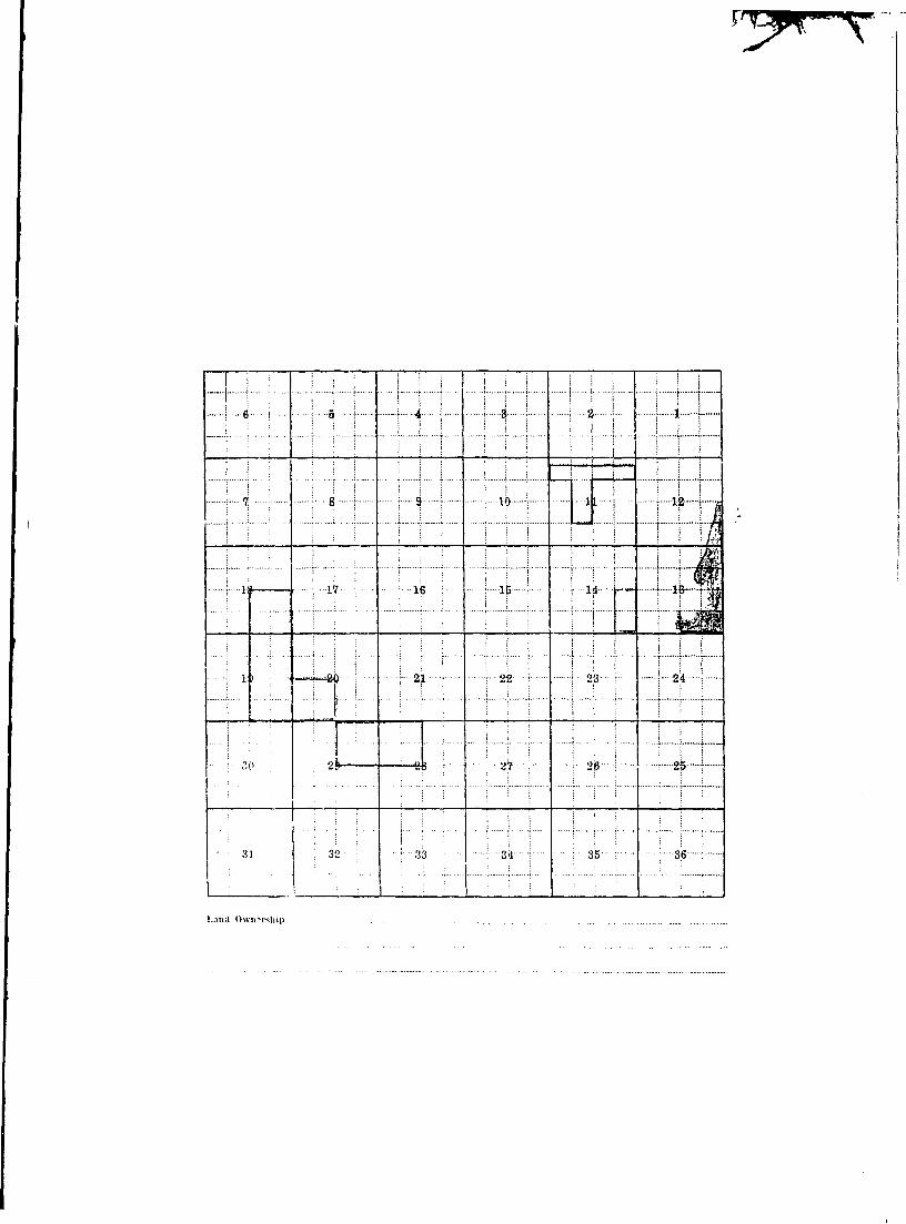
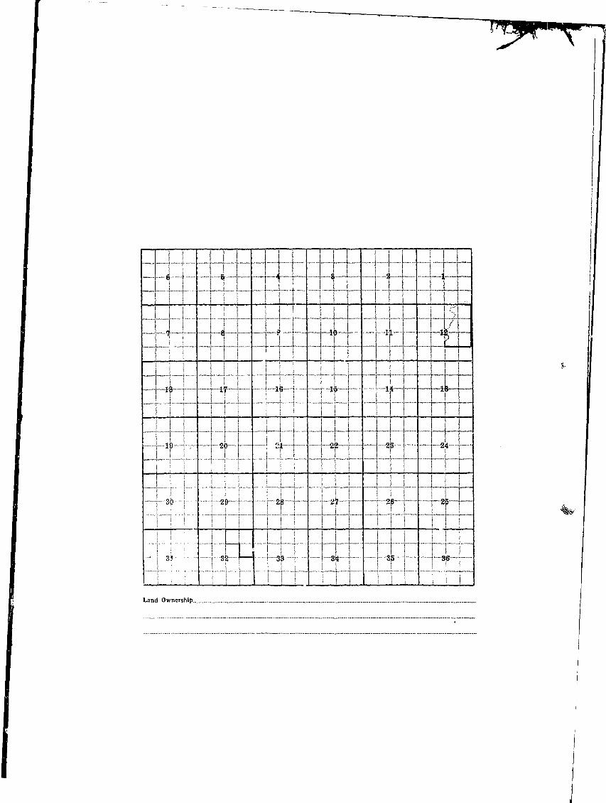
!_T_^ ~r~—\ f | I I I I i i I I I | I
i 6 \ i B 1 - i A t 1 8 * i i ! !••—1 {•—
; s j i l l i i s ! i I i I i I s, ; ; ; i ; i i i i i t j j ; i I T i
I I j [ i I I i i [ ] i I j ] L i iI \ ri '• '• a '• . 1 Q '• i 1A.•..—; • 1 • ! • • • • ; 3-0 !«......
• [ V; ; T q ; 1 H i i • * y : " j ' ' JLjL j T X|S J -
I j ik I \ if i i i^ i | -v? s ~—k—h— 1 11 r—
| \ 10 \ 1 \ 20 \ ] 21- ] 1 22 i - j - 2'p- \ t 2 * I
I I sb I I -20 t i 2^ i i '& 1 i 2$ I t""'2^ !"••"••
I : 31 \ • 3k 1 j 33 ! I-Sji I i 3p 1 \ SjB \
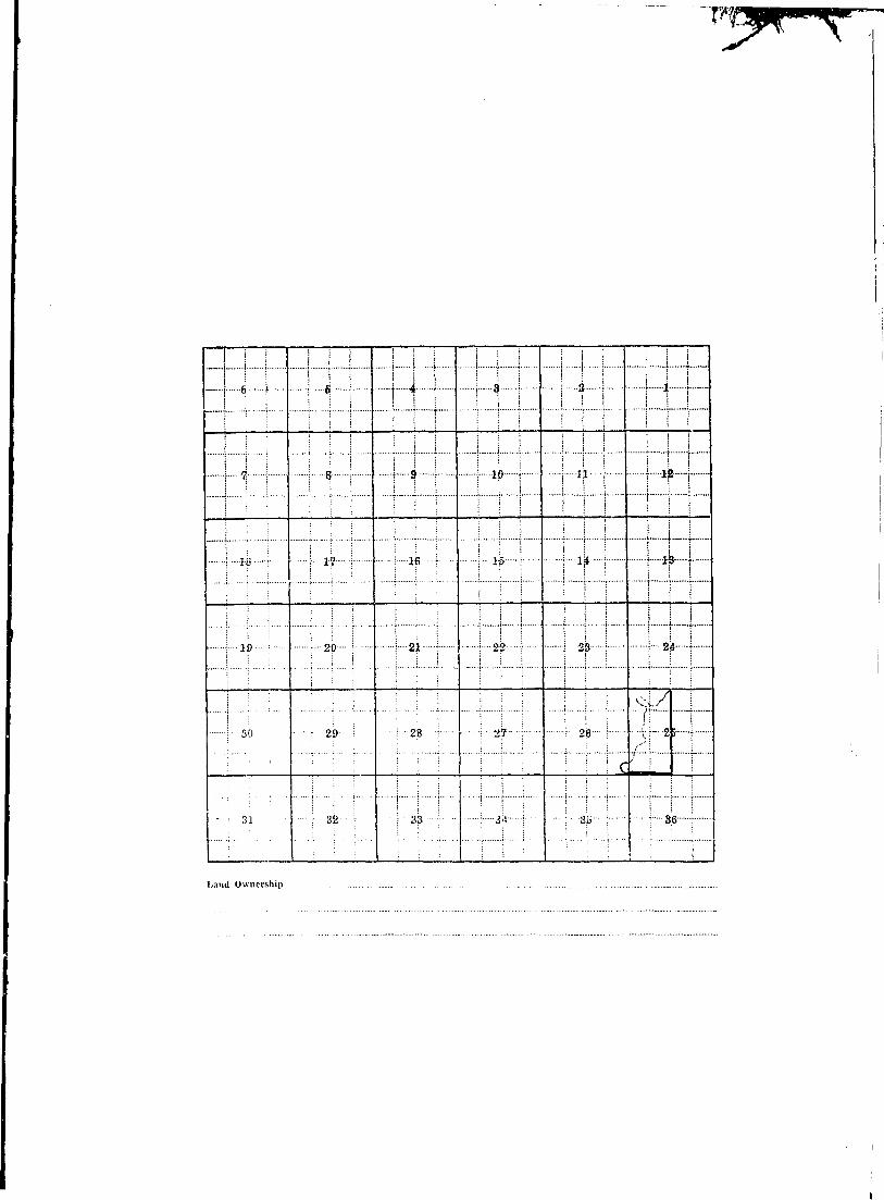
I Land Ownership ., _
1 i
iiI
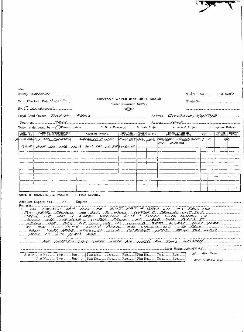
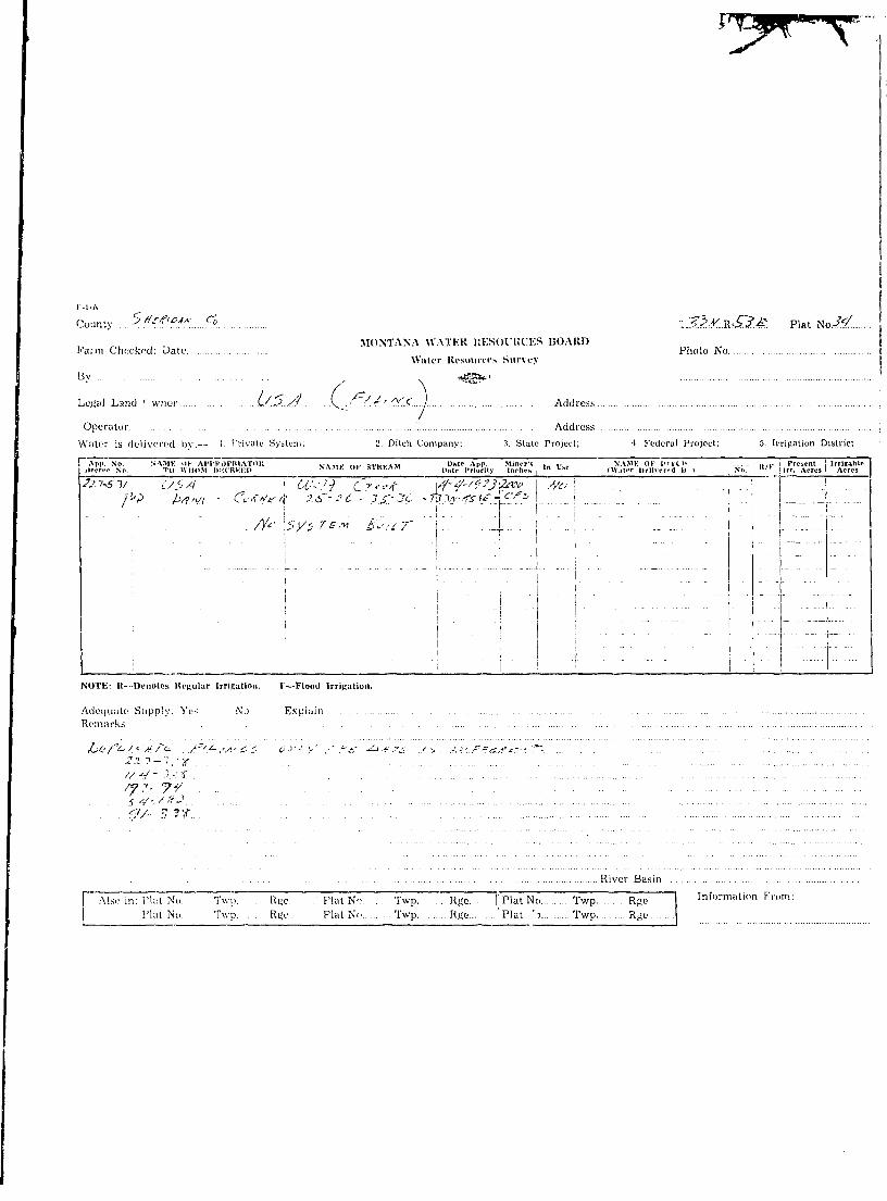
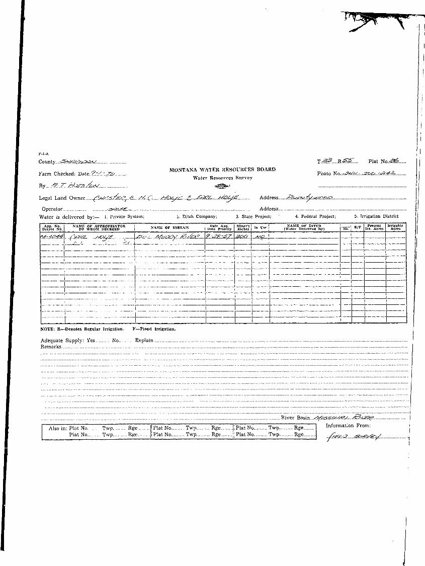
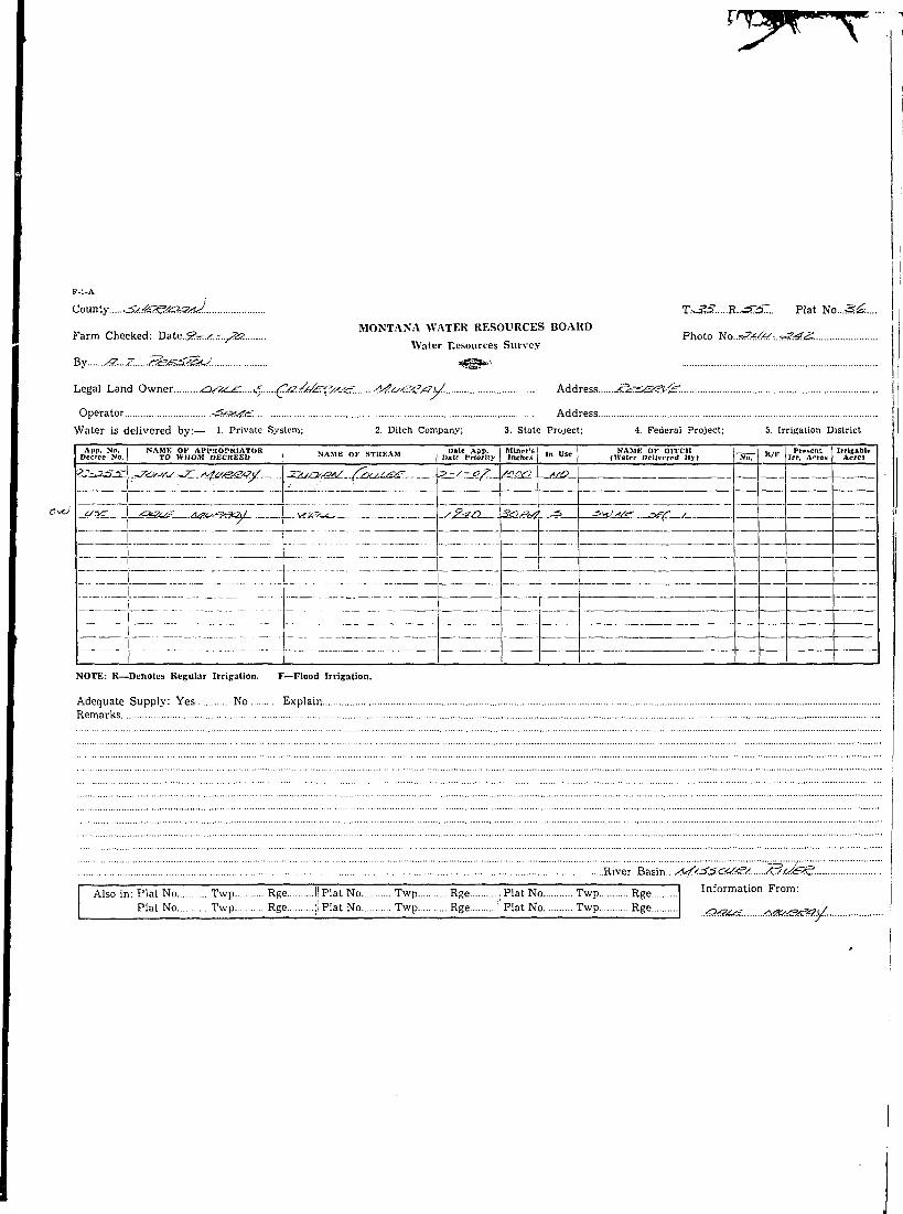
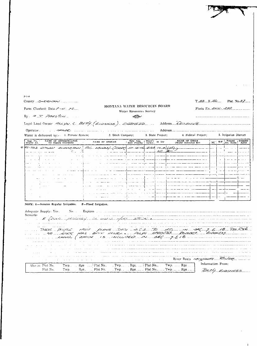
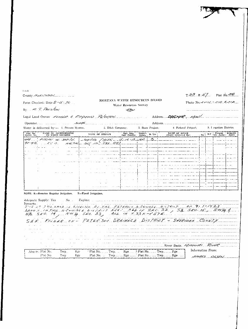
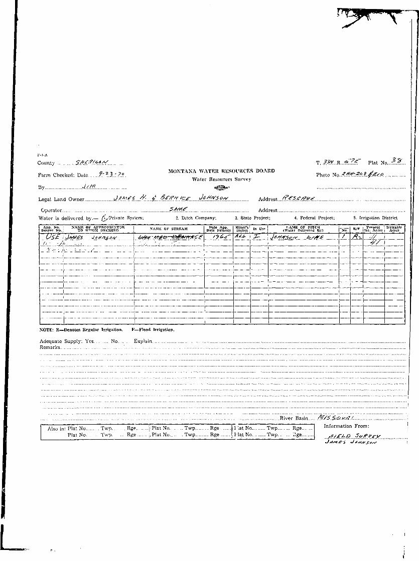
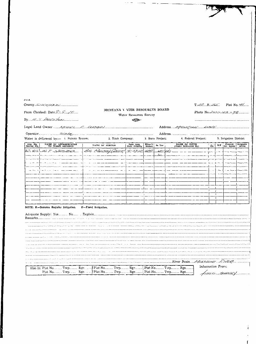
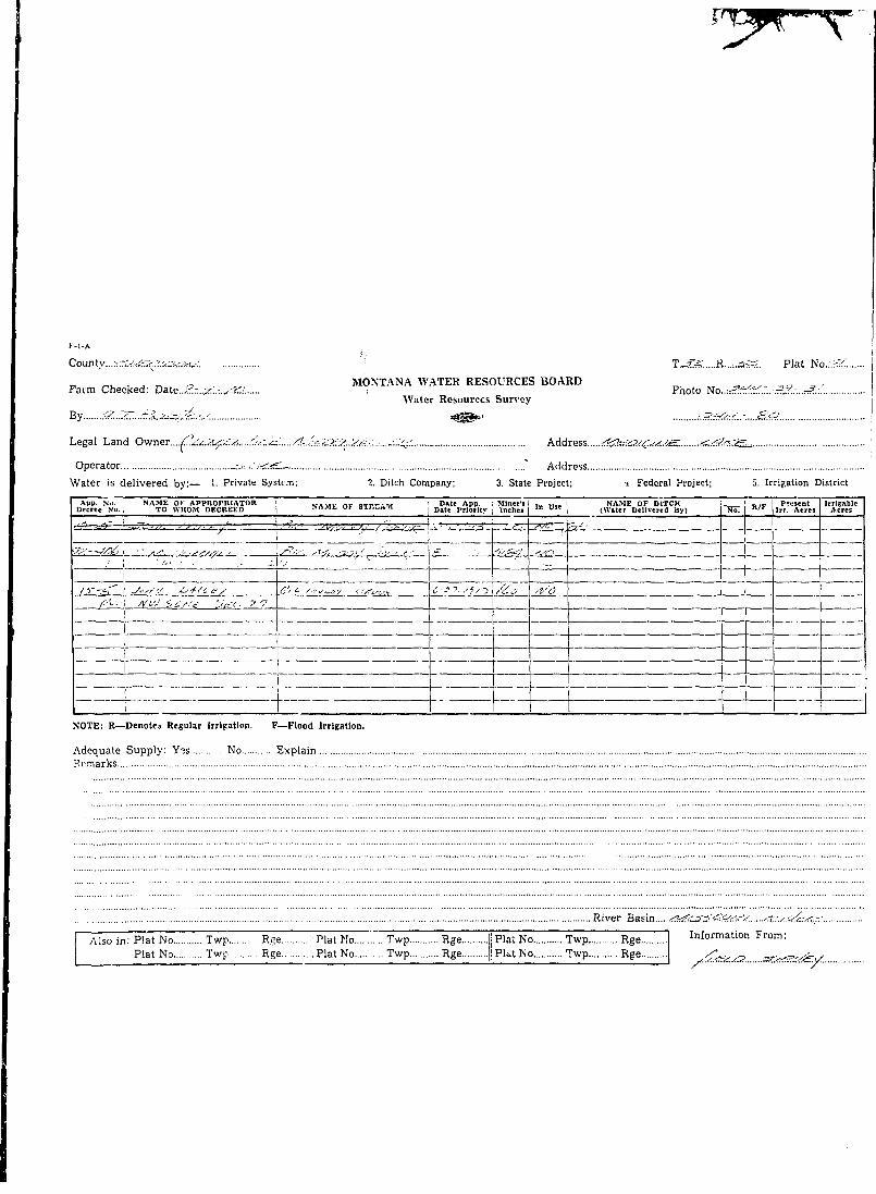
K-l-A
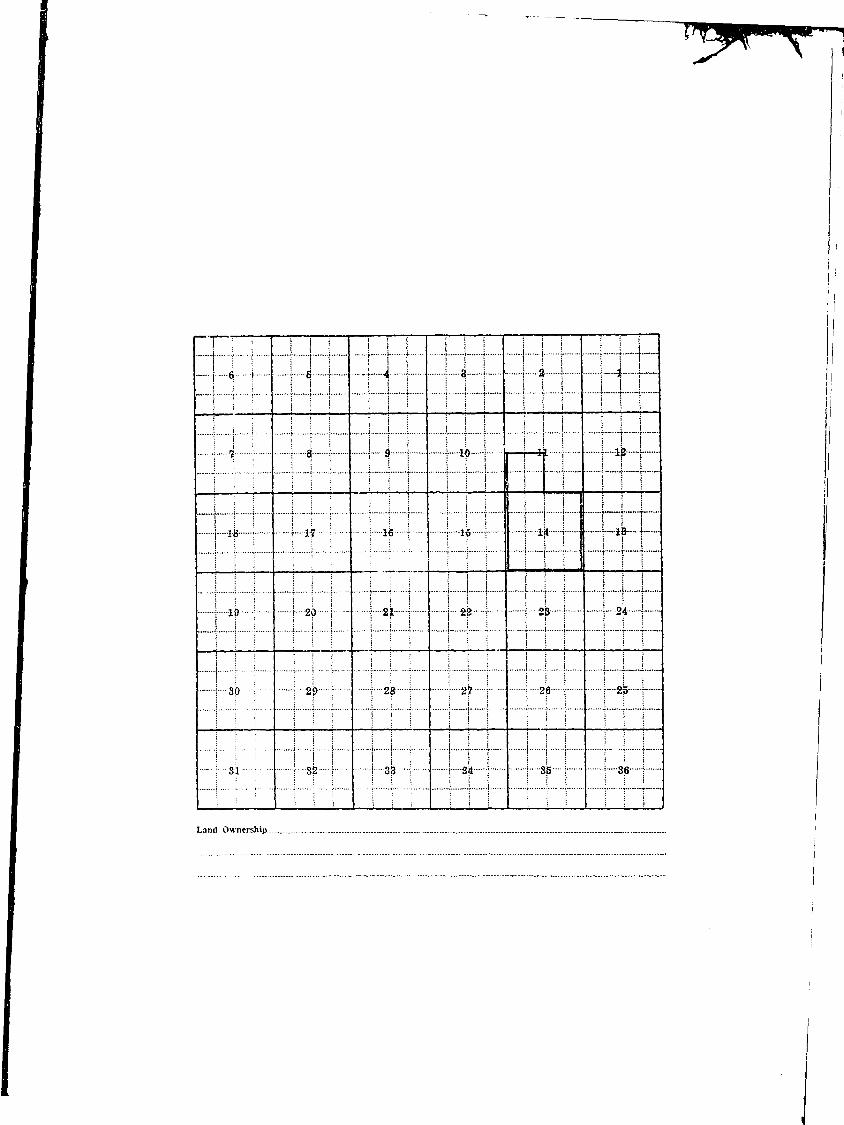
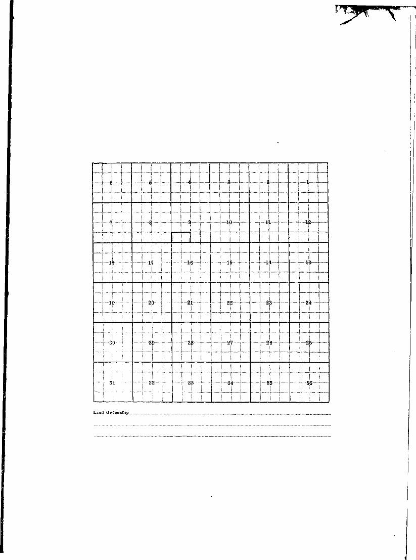
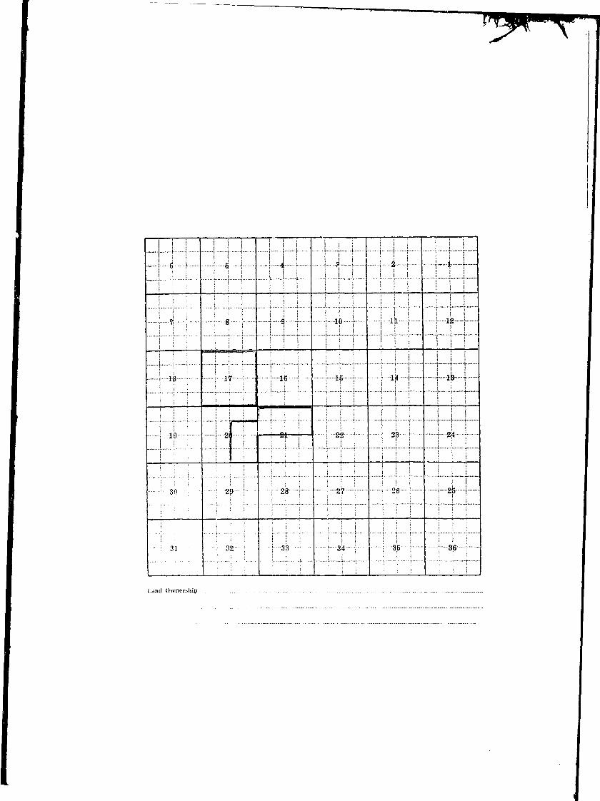
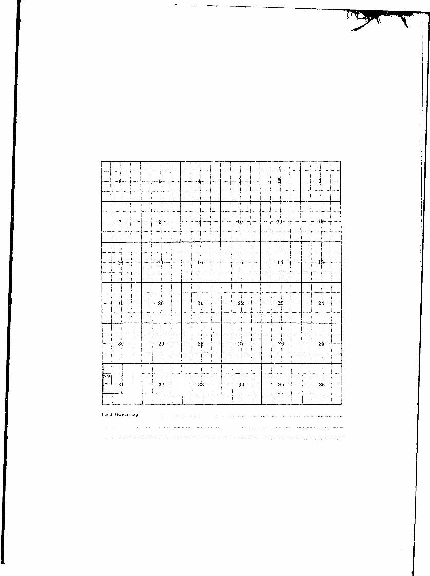
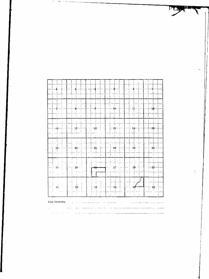
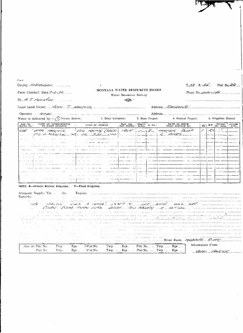
County.....-S*Si54a<?A/ T...J.:tf.....R.sS:Z Plat NoS^ .
^u , j r, ^ , v 7 £ ) MONTANA WATER RESOURCES BOARDFarm Checked: Datc.^-.rrrfe.:Z.?. Photo No
Water Resources Survey
By..CS.-.../!^J..'^£AaaMf.. °<?s*<°'
Legal Land Owner 22/.Mg&&sS. Sff£M.ls. Address ^.<?^/<f^^<a^y../^4^7^/V^
Operator S4.+O..&. Address £>&.*?'£:.Water is delivered by: (M?)Privatc System; 2. Ditch Company; 3. State Project; 4. Federal Project; 5. Irrigation District
App. No. NAME OF APPROPR1ATOR j v , , , ( „„ „ _ „ , , . . , j Date App. I Miner's I .„ „.„ NAME OF DITCH H H ~^Z Present Irritable IDecree No, TO WHOM DECREED * A M t ol bTKl-.AM | Date Priority | Inches | '" " " (Water Delivered By) No. K / r Irr. Acres Acres
^ U££ug/^/^^a&&F_jrjSa£S£:Al j ^AJ^7_._<2ay.Z<S£ 2UMSU26J^?*±L- I A/<=> ^igt f -V ^ / v ^ ^ / i a r _f_ j£_ fe 5 jI /ZAJ0 ^sTilsV&S I
P,O'£>.\ S)/kjT ,^-A/ 7?S£ AjV'^ Susf S-£C /<? Z=?tAf-e^-yS
NOTE: R—Denotes Regular Irrigation. F—riood Irrigation.
Adequate Supply: Yes No ExplainRemarks^ M^. J-atugg**/.. .-A*-!??. JTJHt&T. //<£...... '#.^r......//&/?.....!?......C/?<?J?.. 32sf. 7Z>:<S /^SC43.../S3/e?.
Ti^.e.-.M^JPs. JJ/^C^PMS^ xat,£.....<g/ej:k 7b /vPtscM 6es4}jr/s&....£. Zie.c>.nj./s/.i. o.u./.....X'^^..<2je.£jM. *7te.. ^y?.s. /?. <,4<&&s. e.cvjra.&jz. 4?./..££. t.....<9.<*/!<>*>. ft^xr//. <&&•./£& ire./?.u**3/2- - ^ ^ jr//j£.../£K<:,£.&s **^?/2r/? /C^^/v? zzf.g.. &*.•£&,£>. .<<?.<v^ a/&.g£:.k.....z7^..S?j£/SSs&> ZZSJ?. Z?/<kg.. &£:. ^Q;£>. SJUV. < sf. ^t:^.c?<^Z^. S^TSO. ^.C-^O./Q /V/S*:/. yj£./9A.^r<ff. Tyf/f- &.&z:.....'P.e.&'.M <^(<f./.r./.£ ^r.-r^^^a sr&£r. S^-SZJEAO cs.£>. */*£...../£!££..&
$/:)./,&.. 7r/-/g/.....j&>.&£. *?£e..4?.&..ci£:/!?. TTALJQ <=<!(GJ£Z.&!/JZ. yfsjzZ/aJ. ^s^^^s zz&g....&<e4:a!./c?j'/ctc z& Zk-^-.Q. y.£j?.£.f. /a&a. .„.
A7£.....7's/£/SS£/d....s&^a..?^^#£:.^ /j.& i*/j=Zll .<?<v —MS /?/!?!Gjp.i&g!p6.
River Basin.. /\rt/'rSSOa./Z.£;.
I Also in: Plat No Twp Rge j Plat No Twp Rge i Plat No Twp Rge I Information From:Plat No Twp Rge j Plat No Twp Rge J Plat No Twp Rge ^ ^ JM&C/SJSA/.
1
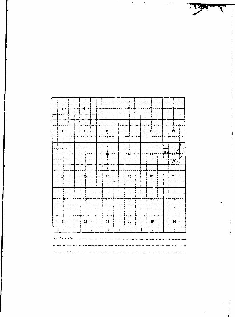
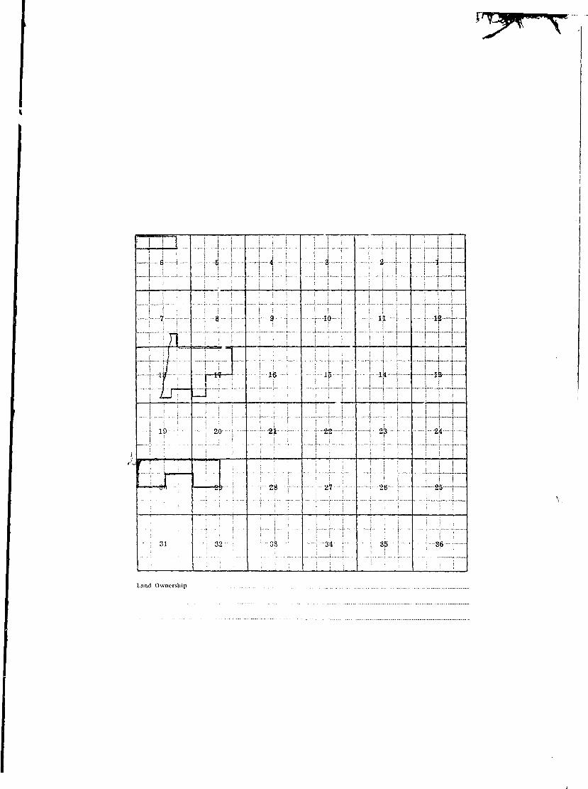
in:!: .ittt: :r x tXX: it!:!:: xtd
I ; i \ | a \ i i \ j ib \ i—j—i L j 1 ik j»
I ! lii ; \ 17 ; \ 16 f j if \ r if j -it \-
I | 19 ! ?--20 | ] 21 \ i &2 i j 2& i 1 24 1
I ; SO \ i -2{> 1 1 2^ i | 2? : -\ 2$ j i—2^- {
I •••- \ 31 : { 32 \ | 3? •-! I -3^ I | 3^ 1 | 3)8 }
I Land Ownership _ '
I
I
I
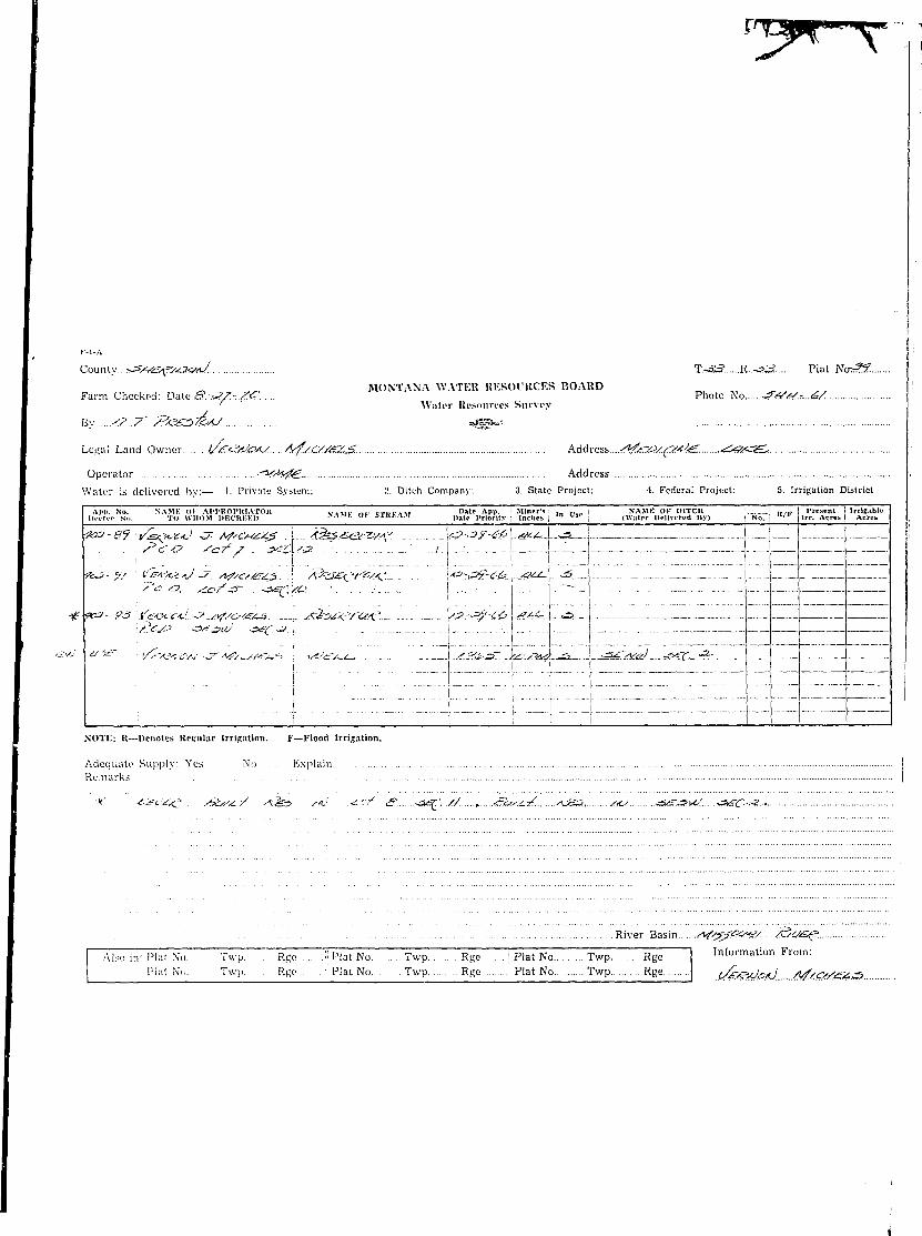
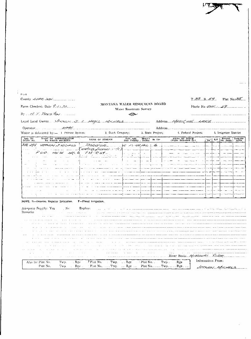
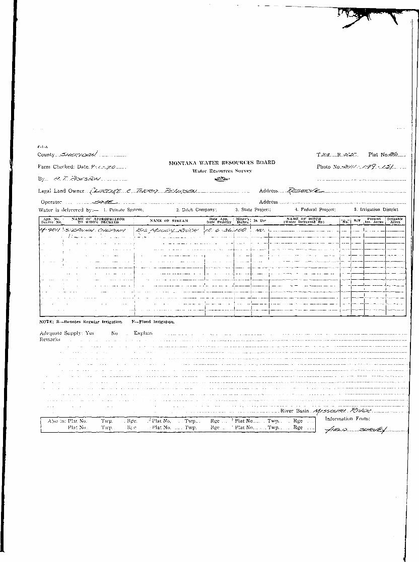
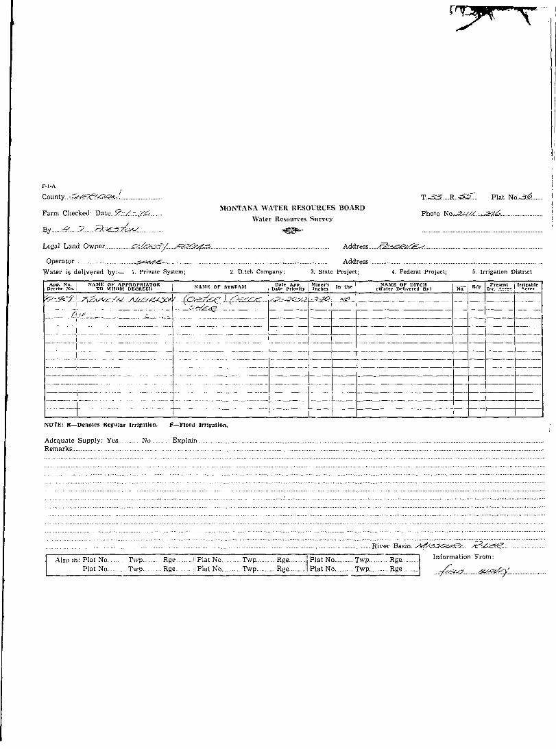
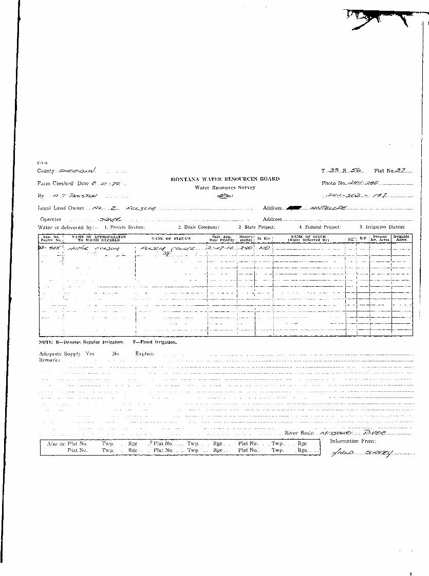
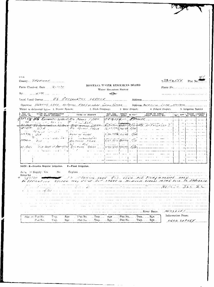
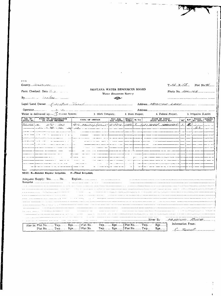
!F-l-A
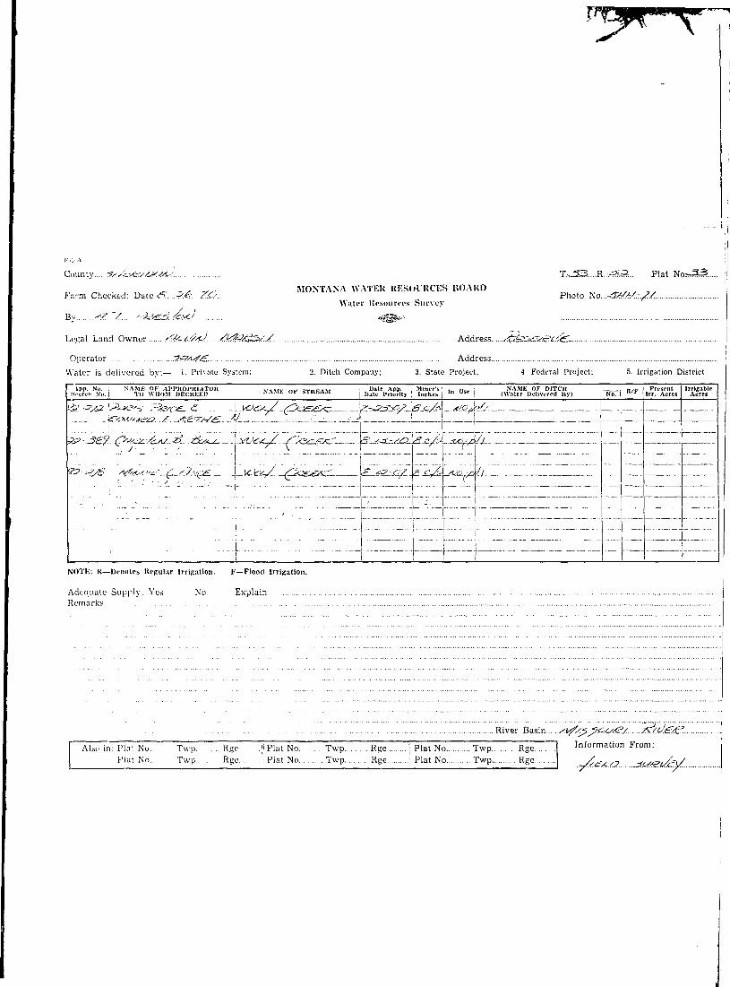
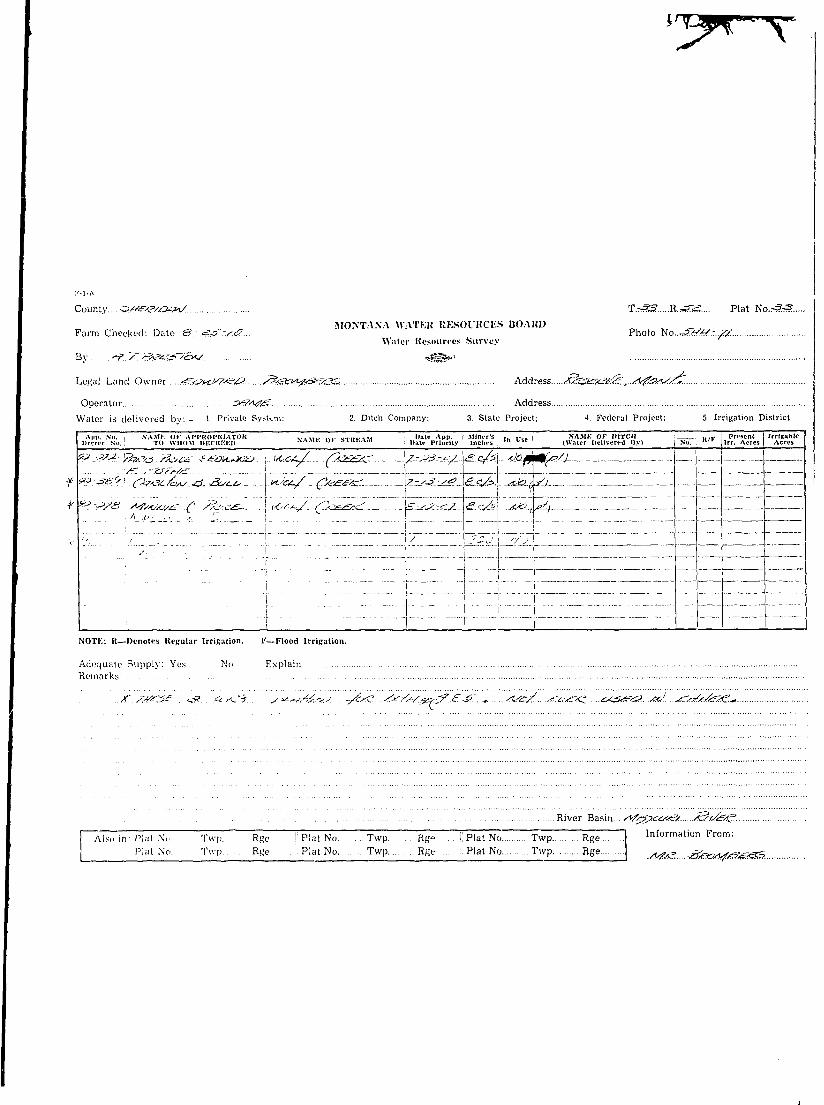
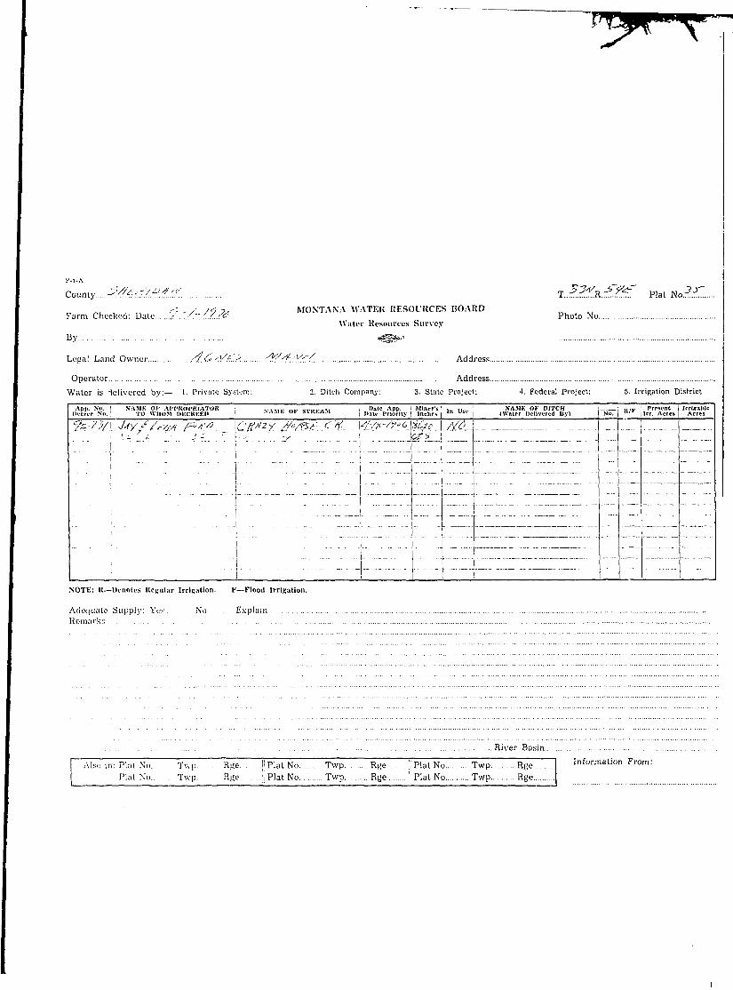
Counly...£/•/££/D/3/.S/ rr.-£r<?....K^Jg... Plat NoS^S*.. i- , 3. / _ , . MONTANA WATER RESOURCES BOARD :=yy~ <— I
Farm Checked: Da\.e..&.~.~/....-.7.O. Photo Nowi?4?^.T. <5 IWater Resources Survey |
By..G..;.!A/SiSl£s«lJ9./)/ »gfg»' !Legal Land Owner J=£/}*/Jc.y>.*.£.....//./J./.#A{. <2afiS&U.S.^/.>/.....^B/?.?iZ:.. Address..£.a<<!?S/4
pS.<?.6£y /kHnz/VZ^MA ]
Operator Address
Water is delivered by:— 1. Private System; 2. Ditch Company, 3. State Project; 4. Federal Project; 5. Irrigation District
I APP. No. NAME OF AFPROPRIATOR i , , „ , n l . - , . „ • , . „ i bate Aj>p. Miner's I ,„ . . . . I NAME OF UITCII H H 7TZ Present I Irrigable IDecree Nil. TO WHOM DECREED j NAMK Ul stKt.A.^l [ 'Jate Priority Inches | '" u s c | (Water Delivered By) No. " / r Irr. Acres , Acres
??L^°/-\-£:Zj-/}S /?__ /&M'SO.*/— "Xf/J^^a^.co^JS'X^jakc. ')£-£.?_-Jzig- S^S^ JiiOX£ 1
u*j£_ J_/e<e M< -/3A$iL- £c~£^£ |/<?-*"/ /OQ,/-*,/? XCU S*? S-^C 9 7y*-c&I ._ _. I
in Jl 1 m] __-IT"-1.J /7".V .."".71._. "7.T7_.". ._7~~_ "1 ! _ _ _ '. '. L""777 7777 7 ' -i--—- —-- | — ~"_2^ l_j ~ " •" "-"• • - - j - - ' - -• - p ^ i -• •- ^ | •
77"77"J7" " "7_'~'" I"'1Z77"7Z~"777^I~ jI i i 1 1 ... r l TNOTE: R—Denotes Regular Irrigation. F—Flood Irrigation.
Adequate Supply: Yes No ExplainRemarks
Atf.f..- &/?.?/~.. &./?.(.&... ./&;. <^?4? A/.O. 6<S./<>fi?£. /?/.<$.*Z'J..> £/£. 4:M£tis.....:.A/r. /V.p S.fi/e/^/G. 7>*#Z.JZY.&.OUJZJ?. X/VTQ. K;jl6,a.ty. r;A£. ,/ Ar.- /\s?.£.....&iAs./: 6fg£s Ts/4- -4/S.4^. SZAAL 6M01£.ye.s.*J.G..... <^.X(.\aK
River Basin. ...yVH/^SoUiCX.
j Also in: Plat No Twp Rge j! Plat No Twp Rge II Plat No Twp Rge I Information From:Plat No Twp. Rge |i Plat No Twp Rge j: Plat No Twp Rge /-faAttk 8.&$2~~
\
I •
.- ! 6i1
I
j
: j j
t : :
j 7
i
j
j 1i
|
1 1
|
i
: 3
..... : 3
i •
I
) j
) • • • !
l ••
! . . .i
1K
o
1
2
7
)
- • • 2
3
;>
z
: i
ll
i
!
ii
""I
2
2
3
i
3
1
0
i
1
2-
2
3
i
1
1
1i
)
•>
?
it
I j
I i j! ! 1 "i ii ii !!. .. ii i
• 1
} j.
i ii v "i !\ ! ! ! - • • • •
i j1 j
1 4! 1I j; i
i '
1 |1 1
j »f
! j
I !
i1
II
- • • • 2
: 3
j
i
fi
u
i
6
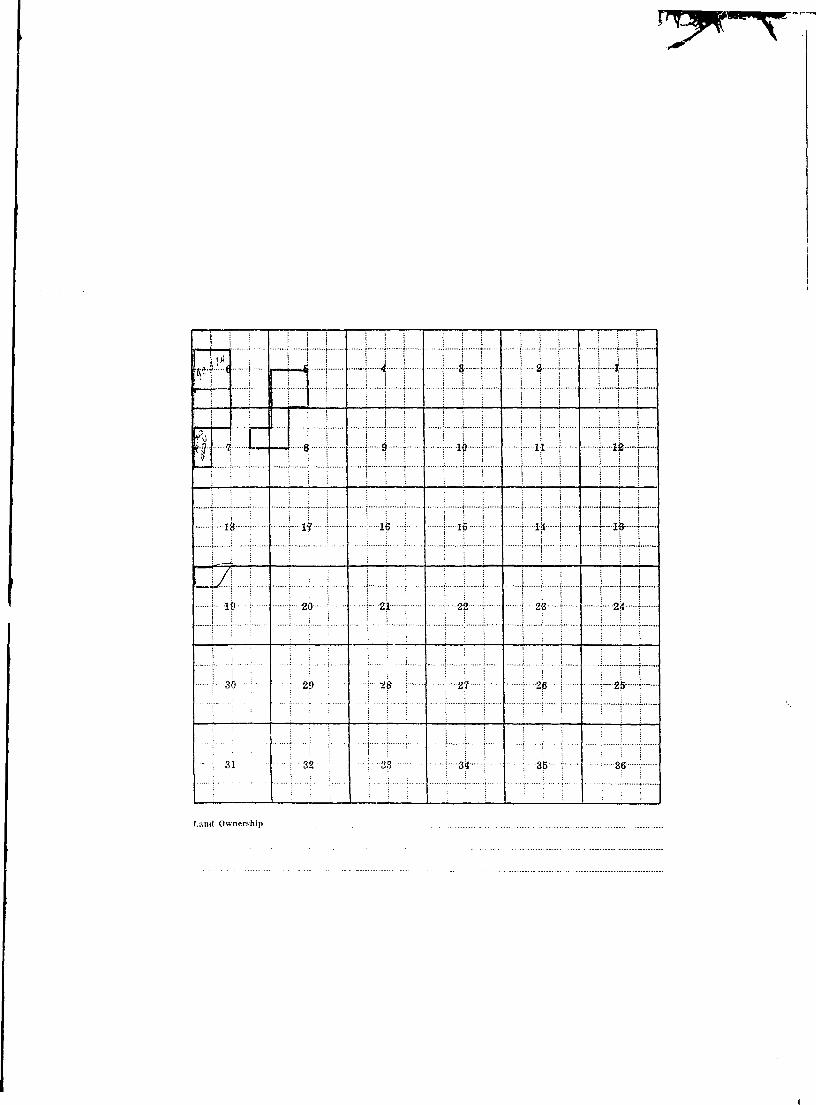
Land Ownership
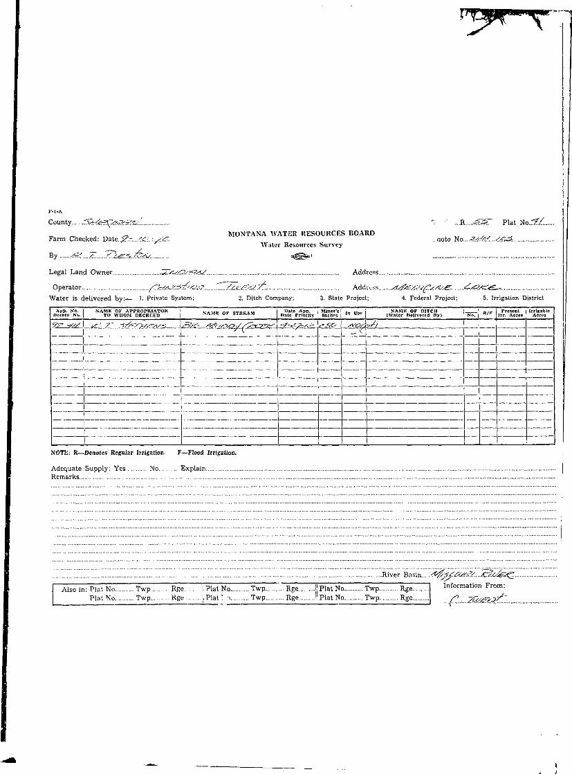
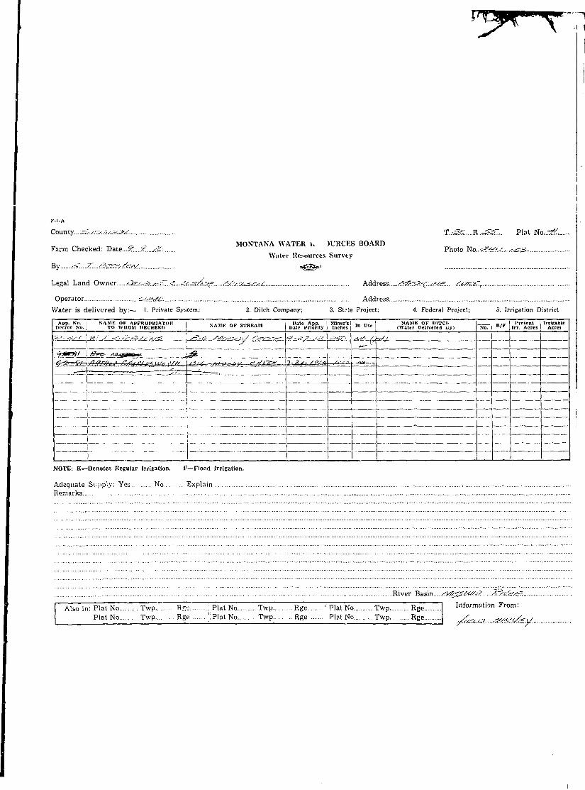
I K-l-A !
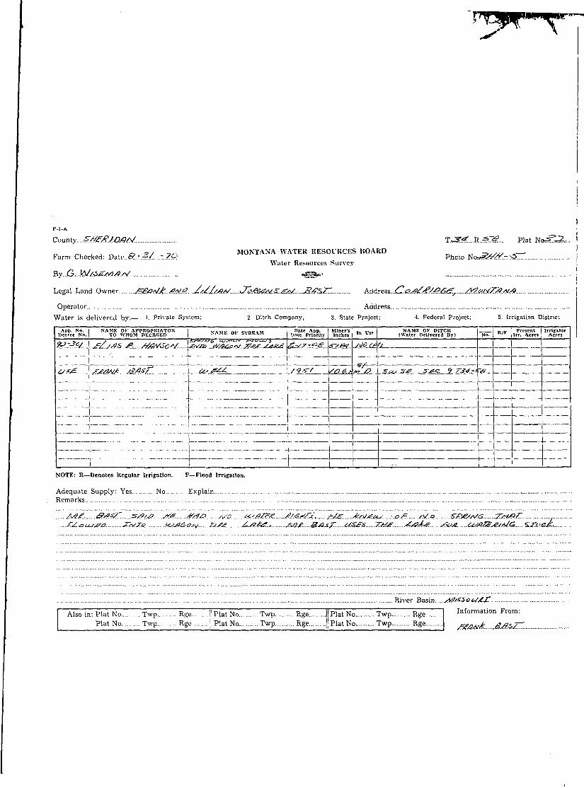
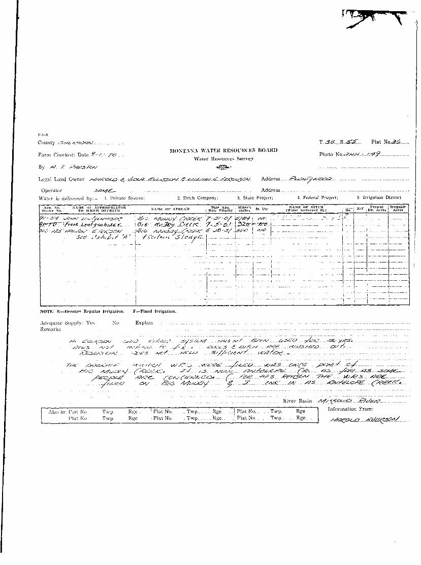
I County.. SM£*7..#**V. T^&.....-R^T&... Plat No. . J^ . . . |
I _ „ , MONTANA WATER RESOURCES BOARDI Farm Checked: Date.£?.-"i?./...~7r<fJ... Photo No..«St>?r<#.-.:?.- Sr.I Water Resources SurveyI By..G.i.M/./..$&y?.t#<x:. *3E*°' I
I Legal Land Owner /}.ad.£"/Q. /./}M.rP.£,.4^r. Addresb £}£t/t.£&a.£j£..:ih../Meu.>t.Z23A(& i
I Operator Sd/y?.£ Address &M#3i£.
I Water is delivered by: 1. Private System; 2. Pitch Company; 3. State Project; 4. Federal Project; S. Irrigation District
I I App. No. I NAME OF APPKOPKIATOR i V A M P nr t T . f . M i " » " App. Miner's I ,_ I K . I NAME OF BITCH . „ ,„ I Present I Irritable I• Decree No. I TO WHOM [>Kl KKK1I I > a " 1 "* "K>-A>i | p t t e Pilorlty Inchet , "* "" | (Water Dellvercil By) No. "•" lrr. Acres I Acres
I ?±Jo(. \j?Z/.-es- P. Ate/u'sc"*' .^/ijsart-sy.ees*x£^.. Jt-L?.-_ee_i£?^ ^o_&?£^.
I NOTE: R—Denotes Regular Irrigation. F—Flood Irrigation.
I Adequate Supply: Yes No ExplainI Remarks
I River Basin..../sa/.$?.<2UAjt.
I I Also in; Plat No Twp Rge ! Plat No Twp Rge | Plat No Twp Rge Information From:I Plat No Twp Rge i Plat No Twp Rge \ Plat No Twp Rge /&^....?#*&Xr.<f;Z^6..&/?.*rZ
I
I '' '• i l l I I I I I i ! i i ! | |I ! ! ; I I i" ( I ! i i 1 !' i i "TI i ! ! ! 1 ! I ! • • j i ! ]
I 6 \ | S; I \—A | | 8, ]• | 2 1 i—1 1—
I | i | | *j | I i I | «H j-4 1 | ^-j
I ' I b I "1 r* ' : ••! C, • ' i I t : L , ."1 A • • 1 1 ••'t&_ - .i....
• ••" [ riy ! T * * ': ." * v " • | " *"P I " ' • T *!*• j T *«* T
I 1 lj> I \ 2Q I 1 21 i [- 22 j - j 2B ! -] 24 }
I 1 30 : |- -2|) \ | 2^ i \ 27 ; ••! -2$ j i-.2^--|—
I - : 31 I ••32 1 1 33 \ \ -3ii I | 8^ I j 36 \
\ • \ \ : i : i i I j : ! | : i 1Land Ownership
i
I
i
i .
I County.... r^^vfy^^/A'.'. T.-J33....R.•-?«?... Plat No^3J3
, , MONTANA WATER KESOl'UCES BOARDFarm Checked: Dale &....=>..&:. S.C:.. Photo Ko...sn/t-S.r.././.
Water Resources Survey
By "Y". V *-}&££>.~'K-'scL stiSSSe.-"
Legal Land Owner .'<fe;<^->c/. ./k?fJ<£jSrZ Address stjkzxSfiSCJe^.
Opera tor 3^?*.?f<(L Address
Water is delivered by:— 1. Private System; 2. Ditch Company; 3. State Project: 4. Federal Project: 5. Irrigation District
\pp. No. i NAMK or AI'PKOPKIATOK vtiii.- ni.- W np,« • nate App. ' Miner's' .„ .,,.„ : NAME OF DITCH 1 , , / P I Prespnt IrrlcablftIi.»crcp No. | TO WHOM DEC'KEEI) ->A.II^ of MllfcA.M j n a t e | » r l o r l t } . ! inch t-s | l n u s c I (Water DollVLTcd Hy) | No. | '* \\rx. Acres Acres
s& ^ ' A e ^ ' ?^c.£- C \-.vc>£*y/-(3=:&&*c- y---^ZJj<?/_£\c/A^ Md(!k>J-L_*T<w#^<£?_ Z. r*;Z:~/-/£. -JL^.. _..;...„ :__ y_i 1 .
?J>.3£C/. (>JA^-''^-'U'<Z>~ -&*-£-- -! yt-'c/c-/. ^yi^z^x:. 5'^^--/-£L£X\/-^ xtY^-Zj-
Si?--^sf: A/^-C'^-. £._AJ^(j£. 1 .\ct-^/ ..(Pz&ex^L IcSL^er^jZ.a&/L_-^.>= U . ._
' : ' • " • ' " : •'"•'• ' ' ' " " ' " \ I I'"~ j - - - - — - — - - -^ _ _ _ _ _ _ _" , — "" i ' " " / " " : ' • ' ' ' \
j" " ••"" " " " I • i I" I ~~' '
I ! ! ! ! 1I NOTE; K—Denotes KcRuIar Irrigation. F—Flood Irrigation.
Adequate Supply: Yes No ExplainRemarks
River Basin., yt^1^jpC-c/^/. Ay.fc.fe^ j
I" Alsc in: Phi' No. T\v^ Rge . .jipiat No. Twp Rge ji Plat No Twp Rge I Information From:Plat No. Twp. Rge i Plat No Twp Rge : Plat No Twp Rge .-/£<->£<-?• jXS&ldfs/..
i
i
I J-1... ~ D I j j 1 1 1 1 1 i ! i i U
! i i j | j i i | M I M ] M |
j i \ v 8 1 1 s I I io \ I IJL ! ? ik f-
_ I i \ -.........! i | 1 | I ! ; | j ! 1 1 i
! l« ; \ 17 j \ 13 \ j 1-b | r l|t | 1 1?" { <
I \ 10 \ |- 20 \ i 2l -i | 2j2 | |- 2^ ! \ 24 1
r 30 ; I 29 j ! 28 ; :--2l? | ; 2)3 | \--2p \
: i I i i ! : | '• ! i l l I i |- ; 31 ; 32- ; i " 3? ^ 1 3^ ; ; - 3 5 ' - ; \ 36 \
Land Ownership .
I
I
K-l-A
County....CV*v(?/<3i*i/ T~S3 R.^ffie.... Plat No.^S-S
MONTANA WATER RESOURCES BOARD
Farm Checked-. Date .&..-..•&&:.::*<#.... Photo N o . . , ^ / ^ 7 /Water Resources Survey
By .. <?. 7T./rt&S'^TZxJ. "MLSS01'
Legal Land Owner ^«iW/'SV<jf«£? ^?3afl-i«eSS<3iJ Address &tk3!3<?&&:..,../4itf!2*H//{*..
Operator -Cr?/1*^ - Address
Water is delivered by: 1- Private Systi.ni: 2. Ditch Company; 3. State Project; 4. Federal Project; 5. Irrigation District
I App. So. NAME Ol AI'IMtOI'RIATOIt . . , . , . . .... „ , . „ . . . . , Date App. I Miner's i , .. NAME OF DITCH , „ . „ i Present I IrrlBHllle IIli-creo No.; TO WHOM IIKCKKKP NAMr. of Slttf.AM , „.,„, PI15flty , in c hes l I n Vsc , (Water Delivered By) | No. | B ' ' | Irr. Aercs | Acres
**'-j?s-r!rs/}7A.?<3.'/&c£: f^oi^vno. \..\A<6/*/...- ./2&s^r. \/^^3-^:/J\£L_c/5\... damtl(^.l
I ..:/!-r..<r-.£v>^r. • I •_ I __L_
f sw.-j»:fj .O?,iX./aAs_^s. £cst.£, \.yL/ae^ . ^3ess&r- J\Zzy^^^^e^s/s-\.^LkLLsU |
^ ^-^/fi.' /t^t/^vt- [(:. /1J.-C£- . . [ ^ . . ( T J Q S S K . - - Sfs.fj:.<iS~ £-<?A -s.*?..^
: "" I i I ' I -
I ' " " • i '• " ~ " I'T ~"~_T""_ ' "_"
i" ' ""'" "' ~ i : i _ __ _.NOTE: It—Denotes Regular Irrigation. F— Flood Irrigation.
Adequate Supply: Yes No Explain"Remarks . . .
. .K ./W4\i>f . <??. << y^'i S^^/6-S.J. . y/£*?...../fir./s:/.jj£*£?..£.-&......... ;Mz/....s~t:sr*t, cx&sys?.. .<id.. ..^/ritz-jlszC*.
. . River Basin. ..<*fsg?c&t*5i! /Esc^S'/sz'.
I Also in: Plat Ki, TVp~ R^e" I1 Plat No Twp Rg« .. |i Plat No Twp Rge I Information From:
I Plat No. Twp RKe . . Plat No Twp Rge :. Plat No Twp Rge \ .A^^..,^k^^f^^^^.

I | i [ _ _ J ^ i , ! j j j I j j ! j j I j
i i 1 6 1 -I i \ -1 3 1 ;••• % • I- i i_ _ I ! ; j j I i I I I ! ! I j | I [ _ J
| % : i 8 1 !•• • 9 | | -10 1 r 11 •••; 1 112 \I ; i ! I i i . ! I I . i i I j . . . . \ i. ! iI : ; ; i I I 1 'j ; i j I i j "I "T" "T
i ' i t i i ; • t : l i i ; \ }~ t ri l l I i ; i : • : ; ! ! I i {
I i« • \ i? • : 16 \ | IB ; i lit | i 19- \
! I i i I... .1 1 ] i j 1. j i I j i j _ i
i- 19-•••!• r 20 j \ 2i ; •••! 22 ! I - 2b \ j 24 {
' = : : : i '. i • ! : ! 1 i • i !
j - 3 0 •• : 2|>-- i r - 2 8 " • j '; 2 7 ! \' 2 8 1 r"& t
- ; 3 1 • - • ; 3 2 - ; \ 3 ? ••; i Zi \ ;• 35 \ ; 36 ;
Land Ownership . _ _
I
I I - l - A I
County. ... 5.«£*!™« ^ \jQ.#..x£l.£. Plat No.-*/ jMONTANA WATKK HKSOIUCKS BOAUD |
Farm Chccknd: Uate Photo No. IWater Uesmuci's Survey
By flgs**1
Lotfal Land '" wner U.I?../) \_.^././'.'Y.C...1 Address ,
Operator ' Address ,
Water is delivered by:— 1 Private System; 2. Ditch Company; .'!. Stale Project; 4 Federal Project; 5. Irrigation District
F" App. No. NAME UK Arl'TToPHIATOK . , „ . . .... - , . . , . , , » , l>»te App. Minor's: ,„ ,, „ SAME OK IMTIH „ lv I Present j Irricanlel.lfrri 'p So. To WHOM DKCIIKKI) NA.Mh llh .illlhA.ii Date Priority i Inrhos \ ' " L " (Water DrUvi-r.d II ) ; No. ; " / r | Irr. Acres | Acres
/ V A f v / - C<jn*ftri$ -is-? c -3$--3C - TJ :w-sfs i* Ac/:^ i I I" I " j . . . . . . . . - ) - .- ..._ , - . I- l .
. j . . j |. j . : ... ...: . • ] • • : : : .::-:;i i • I i - - -
; I : J ;: " i . : - ::•-;•I i ; ' - j - - ' ' 1 ' " i ' " 1 ' " ' I ' 'NOTE: It—Dcnolcs KrKUlar Irrigation. I—Flood Irrigation.
Adequate Supply: Yes No Explain
Remarks .
L>oft-'.<:4.F^....^'.*-//>.-c!:- o ''•'-'•' :•• f-z -±> + .-±...".. .-^. rFz as *-•.-.:?-•
. / / ' / - Jiy.t. .. .J? :'•-.. 7'/ • .
.. . .s^-./tJf;/- z •}•{.. . .
. . River Basin
I Alsn in: Pint No. TVJT Rfje" .iipiatNo. . . Twp. . Rge. . j Plat No Twp Rge 1 Information From:Plat No. Twp Rge . Plat No . .Twp R.He Plat '-> Twp Rge
I County...^/S£A^s*a<?/J. T.-rSS. V...~s^d.... Plat Ncnr??
I ^ MONTANA WATKK RESOURCES BOARDI Farm Checked: Date.8.:.•£/.-.?.<?. Photc No ^.t/M-...^/.I ' Water Itesnurees Survey
I By s-?....7~. 7%3£37&J. ^ S " '
I Legal Land Owner i/^-i^/C A/fsCt/SZCS Addrcsi,....Stfyz?s.(:/<Cr!<£. ^S^£L,
I Operator -=*^k^gf.., Address
I Water is delivered by: 1- Private System; 2. Ditch Company; 3. State Project; 4. Federal Project; 5. Irrigation District
I I Aim. No. NAMK <>l AI'I'HOPKIATOK ..,,„, ..... _„.,, Date Al>p. Minor's „, ,,,„ ] NAME Of HITCH ; „ , „ I Present I lrrlsablc II IICITCP NIL TO WHOM DKCKKKI) NA.iifc Of «BI.AJ1 , ) a t p | ' r |oniy ; inches j ' " *•*' j (Water llcllvcrcd By) | No. j K / r Irr. Acres | Acres
I 1to3-e9 ' ^ i r t ' <7- Af'CW^t? . ..... KkS&et-Cy^. _. . V~S>:-3yrC-fA^^rl.^ j __ j |!I ^ c' /P / c / / _ J*?£!. A3* ...'.1 1 I '
I i-fc J- =-/ ' tfc-Wc-'J ^r. Ai>/cvj£-^$. \ A&j^ric/.'Z.- \*?-&jLC£tA-'&4-. --=5
I -# •?&- ?3 'k/£«3<.-C4.l...-?.-/rf/tcX£iC£.. A:2~3£X?/:£&!C. \/^.-^/.<&.j!i^j^X^£i. 1I ; / . V ^ ^>/r^t<J &C(_\^J .. ...L |.-._ j .
I ,?-/J i/.-ir' • l/otvcir/u- ^A?/^.~/'-^J • i ^ 7 - £ - l . ^ i^ i iO" .^-^v^-^p_^____^3!^kiiftL...^5<t''—^'--- •- -•
I NOTE: R—Denotes Regular Irrigation. F—Flood Irrigation.
I Adequate Supply: Yes No ExplainI Re:narks . . |
I -V -i-&t. *%C .. stZs/^. / s\&5 si.'1 ^'^ £ -A££..//. <S>y. .zf: *3ZZ. s-O. <S<£%5>l*' <3£C-^?..
River Basin Afsjr?€(<#g/. SC/CtStf*.
j A ] s ( ) i n . , , l a t N ( ) Twp. . Rgo J'Plat No. Twp. . Rge . I Plat No Twp R«e Information From:
Piat N.i. Twp. Rge Plat No Twp Rge Plat No Twp Rge .tJkgSfJeaJ. Af./.CAt£r4<.&.
I
\
14 1 !1 1 1 ! I H I I ! hH- IHi I i 1+1—•••' 6 j i 6 i -1 4 i i 3 ! i 5 ; i - I f—
! i i l l ; ! i i l l i i 1 II \ ; I i I I I I | ! | I 1 I j
i I I I ! i I ! I i i 1 1 1 1 1 1 1! Tj ; [ E) j ; 9 f I -10 i j 11 i f IB f
I ik • | i? ! i ifi i I -if \ j ik ! { ip- j
;• • -10 • •; \ 20 \ ; 2 1 i ; 2 2 1 j - 23 I j 2^ \
I ; . i : . i \ ) ; I i | i j I I i i jI : ' ; i [ : ; ! i I i : i l l|- 30 : Up \ j 2^ j : 27 ; j 20 | j-™2^ f
• : 3 1 • ; 3 2 • ; ! 3 3 • ; ! 3 ^ \ ; 3p ' i ] 3 6 \
Land Ownership
I
I K-l-A
I County. ..>5<<^?e-'<*S>A<:. .-. T_^3 R._23.... Plat No-^?.
I - „ MONTANA WATER RESOURCES BOARDI Farm Cheeked: Date. a . :•:?(£-,%?.... Photo No...r*<- .-....7=r<?. : .^?^I Walor Resources SurveyI _ /I By... /9. .. / Si£*r-5.7h/iS =*SS"»'
I Legal Land Owner....<VfrW/S5i<s£l=i... /3MOJK?/<C£:<IS<&£> Address....^ksxSSSf.S?"..
I Operator .>=3SWs*E Address
I Water is delivered by:— (TyPriviuc System; 2. Ditch Company; 3. State Project; 4. Federal Project; 5. Irrigation District
I I A|ip. No. * NAME OK AlMMtOPIllATOR V . M I - ,.•.• m i i n ', Date App. . Miner's i .„ „ „ NAME OK DITCH : , , , / F Present IrriBable I• llecrre No^ TO WHOM liECBEKIl ; NAA1K ot !»TKhAM | 1 ) a , 0 p r l o r l t y | incltei j In use • (Water Delivered By) i No. | " / r lrr. Acres | Acres
I /?s'-2£' }fy//a*?*j£^> *?Asa/jLy£jv*?^s \ / A 3 W ..c-/_.i-*&*r/.S%&*zx?. <3?*arziy....._L_rr ~?~— _««S!^a<iSA ^tr-xr/^S ^ ^ 2 ._.<;•.I .... J ./p>.< -. 3._ ..OK'-VC ^--4^...^-;; £&£L5L J !
I NOTE: K—Denotes Regular Irrigation. F—Flood Irrigation.
I Adequate Supply; Yes No. ExplainI Remarks .
River Basin...A&/£f.&.</•&,<• JK?s.cSi£j€Z
j Also in: Plat No. Twp. Rge I1 Plat No Twp Rge I: Plat No Twp Rge I Information From:
I 1>latNo' Twt'- R^° : P l a t N o T w P R^e ' P I a t N o T w P RBe 1 (?**X^..#»*»CG»ca*
I I <j \ i 6J I -I \ I I ?. j ! i ! |- i t
I i i : j 8 i 1 9 | i *j> \ i i i L j I ^ t
I i i-8 • \ 17 \ ; 16 | I lp ; ! ii I \ ip- I
^ B ; • i • : ^ ^ ^ ^ ^ ^ ^ ^ • ....i i. ....i | j i I... i ;. i i.„..»..!
I I -19 • • • ; U -2' | h-fijk—i—I \ 22 ! j 2b j * 2H \
I ; • 30 • ! -29 •• i i 2J3 | '. 2? : -\ 28 \ | - - 2 ^ t
I - : 31 I 32 | 4 - 3 3 •••; | 34 \ ;• Zf \ \ 36 \
I Land Ownership
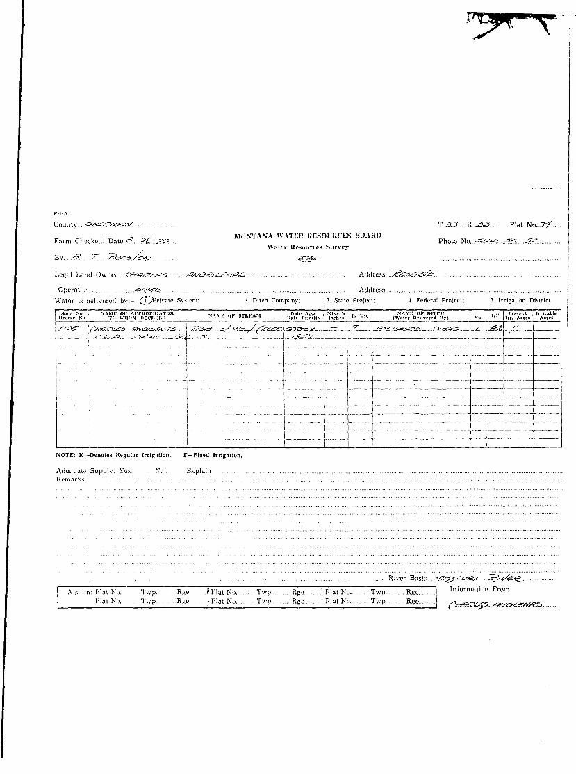
r-i-A _
County 34*<.r!/.?.*:":. T.£.^R.£.^T Plat No. .Z
Ir}.//<7?s MONTANA WATEK RESOURCES BOARD
Farm Checked: Dale / / ~ (./../6 Photo NoWater Resources Survey
By »g§s*'Legal Land Owner /l.C.O/.^.k SW/bV?/.. Address
Operator AddressWater is ielivered by:— 1. Private System; 2. Ditch Company; 3. State Project; 4. Federal Project; 5. Irrigation District1 Ann. No. i NAMK OK Al'PKOPKIATOR • . , , , , . . ,,„ „ . „ . . . . , Hate App. I Miner's < . i t i NAMK OK DITCH :_ ; „ / v 1 Present Irrigable
I Decree No. TO WHOM DECREED i * ' " " '"• » " " • ' " ' i Date Priority | Indies | ' " U > L | (Water Delivered »y) Ni>. | " ' \ Irr. Acres Acres<r/z-?}/\ Jjyf /.*-/£* f=*A-<o \C'ff*zy. tfe/fs't c'^ \4_vfi-/?*c, \xu-c i /YJl Z I TI I _.... _ _ ..
..-.:•-...'- j ... ?.-._ r . ) . . • : • . . . ' . _ -JI fe5lJ - -
"i •• i ~"~z" i - "~" "J ~ n~i~r -_--.—--—--.-| ' "' " ' i ~ ' """ ••_"'"•" - - - - - - - - - -- ' z "Z 1I • '• '• " T "'•• " • " - - - - - - - — - — - y ^ - - ^ - ----- - ^
: ' ' i " "' j "I IHI I"""
I ;. ..;. ; "\ :;../i ;m~L:mi.i.:7...::.ir:i:zii:_izzz:z"ii~ z.i::::!, . . . . t •• . ;...;...:; .L:r : ; : : : :v_ . : . : .L: :": .zz i : : : :mzi :7 : : :":"m7:: : : : : r:: ' ..'J. .'. 77...I" 7.7_'__777I_._ ..._77777ZZ."Z7777Z7Z77; 7 77.777777.71777177.
NOTE; K—Denotes Ri-Rular Irrigation. F—Flood Irrigation.
Adequate Supply: Yes No . ExplainRemarks . . . . .
:: -;77Z:7:Z7-ZZ. River Basin
I Also in: Plat No. Tw p. . Rye. .jl Plat No Twp Rge ! Plat No Twp Rge I Information From:Plat No.. Twp. Rge ;: Plat No Twp Rye ' Plat No Twp Rge
I

I ,-,-A |• County .-&yVe:#>/tx-2AS. T..-2?.....R..r?.1?.... Plat N o . ^ l . . .
B „ MONTANA \\ ATEK RESOURCES BOARDI Farm Checked: Dute..?.r..<.-./T<» Photo No.~>f~#r....:J.-j?&• Water Resources Survey
I By <&.. 7;./?&r57Z*s. t^g"1
I Legal Land Owner -C^fCA-JSi- /?/<S/!f Address SUsS&l^i/ek.
• Operator ~5 %?!<I_-r- Address
I Water is delivered by:—^iy'Private System; 2. Ditch Company; 3. State Project; 4. Federal Project; 5. Irrigation District
B I Aim. No. NAME OF APPHOPHIATOIt . . . . . . . .... - - . _ , , . . , Date App. Minor's. .„ „ „ NAME OF DITCH ! . . . . . I Present Irrigable I• IH-crco No. TO WHOM DECKEKD ; ->A.MI-. ui- aiKi-./\>i I l ) a t 0 j»rlorit.>- \ Inches | l n t s e I (Water Delivered !J\ j | No. | / r | Irr. Acres Acres
I * /s--^e.). /s&/.*?y ^c*? . _ I5>e^5s:.i)..<-3e££-/r-- -<tL<^:-<-f....^.j;/s..^4^s— /. /^-..^iI Sc~ » '- - iL \ CyTise ~ - - - - , - —
I ::"";;:; ;. ~::.:.;r.:: ::zr::: .:_..i....:.: .: n ~. :
I NOTE: R—Denotes Regular IrriRation. F—Flood Irrigation.
I Adequate Supply: Yes No. .. ExplainI Remarks
• 4'. 'V?f/7</5 . . - ' £ > . . <ecT.6cyf<^ . ... i_yif^-xV/.... I
I River Basin. ...<ty.3S&i#e/. ^.(/k?S. I
I 1 Also in: Plat No. Twp. . Rge . .. ,|l Plat No Twp Rge || Plat No Twp.. .. Rge I Information From: , II Plat No. Twp Rge ''] Plat No Twp Rge Plat No Twp Rge ^t^OftftS^. t^ht^C
f
I
I I i i i i i j i i l l i ! [^ i j;... j i ; i. ', i i •; i .... i i__ • i ......
! i i ! ! ! " i i t i , • i • : ' • f i \
i 6 } i d i 4 1 ! i 3 i I ; i r - M I—M i ! M M i M ! j ! I .j 1 !i j j i i i I I I ! i I i la" i i r Ii T ; \ • j i l l ! : : ; ! ; : j i
j i ; 1 s I j 9 1 i \o I j I'JL I I 12 fI :. j :. . | . i ...j i i |. .].... i j ! i L i I i
| ! ; ! j |" ' I I ! " i i "| \ } | ' \ j" ]i i ; j : • \ \ '. i . ; I i j i j !
j ; I . ; ; i }. I. ....; ; • „ . . ' j j | # - , ^ ^.^
| 1« • 1 17 1 j 16 • - ; | 1^ i | l i | | •& I
i ' ! \ : • J [ : j | | | j j ) \ t
I 10- l r 20- ' !--2i- ••: I--22 i j 23 i ! 24 1j j : : : I ! i : i : ; I ; : • \
j ; • '. • i . ; i l l ! i i : j i
:• 30 \ r 2f> ! j - - 2 $ •; ; 21 ; i"-2jB ! T 2 ^ f
• • '• '• ' • \ \ \ • \ \ i l l '• \ :
i i l l ! I • I I I I i ; ! ! !
' : 3 1 ' • • • ; 3 2 : i - 3 S j ! W \ ; • 3 5 ' | \ 8 6 ;
Land Ownership . . . . . .
t
I
F-l-A
County >.#.<*>&«*/. 1.-}..?Sf?X.:?~1$£. Plai No../.^.
, , . , MONTANA WATER UESOI.KCES BOARD „ „„ ,t ,Farm Checked: Date S.?..;/-.?.?..... Photo No.....^f.<f^r..<^.T>r
Wilier Resources Survey
By U/..'?'. . *@~'
Legal Land Owner -.?G.4?><* .<$...../...C.k'X...•:•-• ::7.^:.-..."-^. Address ^.^.'5:^'...^.<'.<r:<r./....«5j/^.r;.
Operator '^<!?.^7 Address
Water is delivered by:— 1. Private System; 2. Ditch Company; 3. State Project; 4. Federal Project; 5. Irrigation District
Ajip. Nil. i NAMK Oh" At'l'ltOI'KIATOK V»MU- iw.- C T I I I . ' » « Hate App. I Miner's i . . . . NAME Of HITCH _! ,,,,;. Present IrrlsableUrcrci' No. : TO WHOM IIECRKE1) j ail . ' lb » • aim-.A^i : Date ITlnrlly i Inches j ' " u s I (Water Delivered By) I No. | K / r lrr. Acres Acres
2I-J-4<;L.\ OS A• #„**** "-A?&UMPIS TiTFZ? <:'/p.ir-L'x ^'j-'f^i-&±:?.L. .! yy.iL...' _ .f^.tZs .A'IV Sii'Al/f/ £•£'?: 3'\ 7' JJ/*"-*1 J ' ^ « ' _ _ ~J 1 !
'i ' " T 7" . ! "'". ~.~7.~ 7 7~7_ "'.'..""..".::~i.'Z'.l'Z~SIIl.\ _ __ i
7"" 1 "• " 7 •;: :::~" T . \~... n . 7 -77 . . . . 77_ _.7.:. .7.7 77_:77 'T: .7777; 1 _ _ . ..
I " T" _ ': " i • : •••"•l--~-l " • • - - ~ T - - i . : . - : ^ . = : :.::: i - : : ! • • • • " ! • : : • - - : - . : - - : . : : : ~ : ~ . ~ ~ . .
1 : 1 ~ ' - - } • - - 1 ••— I ~ - - -NOTE: R—Denotes Kcculiir Irrigation. F—Flood Irrigation.
Adequate Supply: Yes No ExplainRemarks .
~~"//.:.S. •yyj.ri'-':'' ,k<ssf.i\ y^si/iTi? .•?,-•/^ r
/ s .1' r.rj-p j r ./^.c.'.+i c-.-,/L-,y
1 River Basin A4/5.£.&.c>.s?. s.
I A l s o i n . p l a t N c K Twp. Rge ji Plat No Twp Rge I Plat No Twp Rge Information From:
Plat No. Twp. . . Rye ;: Plat No Twp Rge Plat No Twp Rge j?'<£*G. S^'PifSy
I I i ] \ 8 \ ] i ] i ib ] | 1} I \ ijs \
I 1 lk ; f 17 ! j 16 I ; If I \ iji ! \ If T I
I i I D • • j 1 2 0 i 1 2i ] | 2? I j 23 \ 1 24 \
• j - 30 -: • 2& i ; 2^ | ; 27 j ; 26 j 't~"2p T
I —•! 3 . • ; 32 \ • -\ 3 3 ' ; i 34 : j • '3? " i \ 36 \
I Land Owners Alp .
' K-l-A
County. .<VtfSe<.-k*!/. T..-^?.....R...-^^... Plat No~?^T....
,5 MONTANA -\VA1EK KF.SOVKCES BOARDFarm Checked: Date.?.:/.-.,<*<?. Photo Mko..<rA(//...:.....jS^:.
Water Resources Survey
By s:?....77.. /-&£:.-57CHJ "Ss*1"1
Legal Land Owner S/^^A/CW. .-_?;.....<•. Afe^r^ A^/c^/^^-S Address A^S\£?./.^./Mef.. -C^7/fci2"
Operator •g&tfg' Address
Water is delivered by:— 1. Private SystaTi: 2. Ditch Company; 3. State Project; 4. Federal Project; 5. Irrigation District
App. No, ' NAMF. OF Al'PKOPKIATOK VIMI.- t\v c-rwri™ IJ*tP App. | Miner's .„ ,,,., NAME o r DITCH ! „ ... Present I Irrigablelli'crrr- No. Tl) WHOM IlKCItEKIl .NA.iif. u> a i K M J i Dalr Priority | Inches j ' " 1 !" : (Water Delivered By) | Nil. " ' * Irr. Acres | Acres
3S&^cr_ v&&vc»!S~jrAf,csS^/-£> ! -Sase^S- /ig: . ~-«? .J.-J:-6SL^£, J__.-5- - ' _ - tJ442 fetf£-/2lCI«4<S<S5.. !-"£i?..X !
.... _ '/P..CZ<?- SYtC^CT O^.^L--. 7. 33 .r ifj! ._ _. ! L
_.."".:r. :T:_: : •" :~i::~~~i:'z::~' """' ~ I"" ~' " ' " ' " " z r _ _ i • " • " " " _ • • _ ! _ • " • • _ i , ' I
•••"" n ~ "" i t \.~' ~ ' ~~ :r ' "V"" " " "z~~""_ • • - - — - - - j ^ - - j j - ^ ------ _ _ _ _ " Z I L _ _ 1 _
[ ;'•.::; :;z~~;_::_:~'~ ~ "\.".;... ~ z:~i :"ni.".'n_ir_~_..:.___r : zi_Lz: :
i ~ " " " ~'~i h' "i j ; r ' ' ' i " i " T I "_ rNOTE: R—Denotes Regular IrriRation. F—Flood Irrigation.
Adequate Supply: Yes . No .. ExplainRemarks
River Basin....Af/SZ.otS.'?/. X5frfe<f?
I Also in: Plat No. Twp. . RKu I1 Plat No Tvvp Ri-e. I Plat No Twp Rge I Information From:j Plat No. Twp. Ri;e ;. Plat No T-.vp Rge Plat No Twp Rge | .v^^VK^-.....^c^SZja
iIII
iI I i I i I i i i l l \ I i ; ! I
• M l i 1 ! i ! i i i ! ! i ! \; ! ! • I i • • j : i I
j - i 6 i 6 i ~i 4 f i 3 • I - ••% i i 1 1 -j S i : I | i i ! i I I ; i ! i i i
: : i ; ! ; [ i : : ' ; \ \ j ' • j
; % ; \ 8 | I i T 1 1? \ 1 11 i | 12 \
• : • I '• : ; : ' \ ! : i ! ; i
! ! ! T ! \ i " T ! J i j ! ! t ' ~ T VI i ; i i ; i : i i i I i i i ! I {I IB • !••••!? \ 1 1 6 - ! I i^ i \ ill j \ l!J- f
\--ID ; h-20 ; >-•• 2 i ] |- -22 1 j - 23 ! {— 24 \
i '• •• ' \ '• : : : i I : \ \ \
\ : • • • ' \ • \ \ I : : •
;• SO | - 2 9 \ :• • 2 8 - 2 7 : v 2 6 •' : \~Zp f
- ; 31 • -;• 32 ; i 33 J--34 | ; 3 5 ' ; ; 36 ;
Land Ownership
i
!
County .^f^s-^W. T.>^?.....R..^Si>~. Plat No..^?. i
MONTANA WATEU UESOl/KCES BOARD !
I Farm Checked: Date ^-.t' -./*&. Photo Ka:J*r!?.:..*.Z6..-*s:Ar.*.-?.'.....
Water Homines SinveyBy. .<? V &••*:'z>/•r*s .. . --«gc*«" ^?..<:&...:.-*?&£.Loucil Land Owner . . - ^ ^ . j / ^ v ../Oivj./wir^s^f Address ....^r%r.s^sK."'<.^r
Operator .-a***?*? AddressWater is delivered by:— . Private System; Z. DiU h Company: 3. State Project; 4. Federal Project; 5. Irrigation DistrictI App. No. NAMK OK AI'I'UOI'UIATC K . . . . . . . . . . „• , , . . . . . , Hat' App. Minor's . . . SAME OF DITCH . , , . . ! rri-senl I Irtlsaole
l u m p So. TO WHOM DKCKKEI) >AJIh Oh STKf.A.l „.,,,, |» r | , , r l t y | n c h f s l n L > 1 (WjliT DI-IIVITCCI By) i No. j " j In . Acrci | .'.crgr.
* 3{.<<~-s?c ^/c*/'v s^.ss-i-yc-'-'x' !^J>C sv^/jLioy .-C,-c*s>^ •*? - -<2f\^^<: ' *s*>. • . . .. •- i • - - -
.; !'".." \ ' . . ." i"." "" J~7'~ • "~."\"..~~ '.... ".V.""'"".. / i 7 . 1 3 ~ I Z - ~ I ! 7; : j ; !__ _ I j
] ' • • • ; '"""•' ' • • " • i — - i - |
; " """" ; I'" • : i - - - ^ - - - - - - \ _ - ^ ---__
< • " i '• \ i f""" _ i r~•• • • • " ! " ' " " • " i " ' " - " i ; •
I ; | —,.--- , r . . . -p. . . - p . — .NOTE: R—Denotes Regular Irrifation. F—Flood Irrigation.
Adequate Supply. Yes No ExplainRemarks .
.. ^*V'.,21Vi.-^i^j si--^Sf\y :/c .. Ss~s-, X*^Ji . .^clrutS) ^^-( . . •*-*fr(_' /~P....^L '^* -^X^fcivi^/ ^^(£3 . . . •i^>-xi?<C?l/ ..9
.-c-'C'. . itJcs^;.^' sSfj-j . .t^xsarAS. ^JCIX.<£ ...yitr^lt.
River Basin y^/^S^^^^?/ .. -^-exfc^f*
j Also in: Plat No. Twp~ R^e .i'Plat No. . .. Twp. . R^e . ) Plat No. . Twp. . Rge Information From:
I Plat No. Twp. R^e . Plat No Twp Rjjc . . Plat No. Twp Rge \ ^2fS/y. £7><3S,*j£z5../Zy.'/*:.
!I
I
I | ! ; I ! i ; I [ | ; i j ! | I | [...[ I j i | II $ \ | a --j -1 4 j j ij ^ | a | \- i \—I \ \ j j ! I ! | ! J j | j i i l I
! I ; ....•• ; I i j i s ; I I [ 1 j.
; 7 ; ; 8 1 | S 1 1 lj> ( I I - I i I f c " j " ~ »
j 1 | ; ; - - - l 7 - - - i ! 1 6 ••••• j if i \ Ik fc>— \ l -"ry
i ! • ! i i i • i l l S i ! i l l• \ \ • \ • i I I ] \ '•• \ '• ) •
I 1> -~~U=g() i r 21 - : 22- -I I- 23- ! ! 24 \
; • . j ; : : ; i ! i l l ' • !
:• 30 -•; 2 ^ • •—S6 ; [ ?i [ r ' 2 8 1 i~"2p f
; . ] •. i • : ! I ; '. \ I i l l
3 1 ; 3 2 ^ • ;• 3 3 ••• ! • 3 4 : ; 3 5 • • ; ; 3 6 ;
! . ; ind O w n e r s h i p _
I
I F-l-A |
I Co\xn\.y...^&r£Z&uc**a/ T. =*?.....R.-^£T.... Plat No.>3£
I „ , MONTANA WATER RESOURCES BOARDI Farm Checked: Date..??-.^.-../& Photo No..ra?<^.r...-Z«2..-?3.-£^.I Water Resources Survey
I By tf.:7~..i$.}!Z2.J&/l/. -^g" 1
I Legal Land Owner ^!^/K'ci./^^'.l..C...^.C: /r/CM:/^:....^,....^3CC.....^/iS^/.'S. Address ZZ^Tu./y.KdP.asZ?.
I Operator <x#b?<£— AddressI Water is delivered by: 1. Trivate System; 2. Ditch Company, 3. State Project; ' 4. Federal Project; 5. Irrigation District• I App. No. I NAME Of AI'PUOPRIATOR i . . . . . . . - R c ~ n c . M Date App. Miner's I .„ . . „ • NAME OF DITCH . TZ Present I Irritable I• Decree No. | TO WHOM DECREBD j NAMb OF STREAM Uate Priority Inches | '" t s c ; (Water ncllverea By) No. K / t Irr. Acres Acres
I A^^s^Lfi^s^.. -jaOX/£—. ..__4^i'^- -^^asj^/^^cS—' r^^se^Z-iaa^L. _^>
I NOTE: R—Denotes Regular Irrigation. F—Flood Irrigation.
I Adequate Supply: Yes No ExplainI Remarks
I Kiver Basin ..-<^^s^c»,^!ry...^?.cJsi^ j
I I Also in: Plat No Twp Rge II Plat No Twp Rge Plat No Twp Rge I Information From:I Plat No Twp Rge !i Plat No Twp Rge Plat No Twp Rge -J&Z&.-&. £&<*?*&.</.
I
I
I I I ! I I | i I i i I ! 1 i I I i ' j I I I
- I J I i I U \ I a ! 1 4 ! - 4 - 4 \-i I.. I. ! I ! i i i i 1 1 ! ! ! | jM s 1 i j i i I i l l M i 1 [ _
I I i I .1 ! I .1.1 ! I U . j... !.. I .~T"M! i ! I ! I I M I ! i M i "| |i i ! { & j- ] 9 j j W----J -~j 1|L I } 1 ! f~j i I ...! ..I I .1 !__.:.. i . . [ . . . ! .... I ! ! L . i
•• j j ;" ' |" I'' ! i ! i ' \ I • ! j ' ! I" '
I i If i t If j j 1JJ I \~lf -; 1 1 j p ^Ift^--
j ! i 1 1 ! ! "I I 1 1 1 1 1 1 "T/fufi ] t i i [ x j i i i j i s i i Lii I ; ; ; i I i I 1 i I i • i I I i
! 19 1 [ -20 1 ; 2i i 1 2£ I -| 2B I -|- 24 f__ j j ! I I | ! I I I j__j J ! 1_ I I !
I I ; i i | i | j | | i 4 4 | | Lj__! 1 I • \ I I I I ! j ! i l l I ! !| 3 0 | \---29 | | 2? j ; 2? \ " i ?? j j--2& rI \ • I I ; i I . i i I i l l I ! j
" i " i i I ; i j I ; I' "! j " I ] j ' ' I I I*
i ' • • ! I i I I I I I ! • I i i: ' : : : i j : i I i | • • : :
I I 1 i i i | i I | i i i i | i i i-~ ; 31 \ 3^ i j 33 1 i 3ft i | 8& ! i 36 v
\ ' . \ : I i l l ! i ! i ] ) '•• ' :
} ; ! ; I \ I j i i i i : : ! i
Land Ownership _ __
I K-l-A
I County.. .^tM-'/zV^xS/fJ. T. VS: R..>?.iS.7.. Plat No.^<S.
9 MONTANA WATER UESOl'RCES BOARDI Farm Checked: Date. ?.-.<.-,?:<2 Photo No..:^^/. .- . . .^-^..- .^.?/.•A Water Resmim-s SurveyI By <?. /T. .^3t"a/S-V "SsS*1
I Legal Land Owner. ..£/^££^£.....C....2ii7&*&!?. t&jtexgSGM. Address /^avsKfft^fe-n
I Operator .--.•^T?V$S£1_ Address
I Water is delivered by:— 1. Private System; 2. Ditch Company; 3. State Project; 4. Federal Project; 5. Irrigation District
I I A|)I>. No. NAME OK Al'I'ltOl'RIATOK v\Mt ..i- : ,« ,« Date App. \ Miner's i , , . . , . NAME OF DITCH : „,... I Present I Irrls.ihlc I• llecrec Nn. TO WHOM I>K( lti;KI> , NAMI-. or STKfcAM i,at l, Priority \ Inches | ' " u " ; (Water Delivered By) | No, | " / f | Irr. Acres Acres
I y--9£>S/.\rSsZZ>:2VSSA/-<:/-Sj£y^/ui<7 *5>& '-V^i^-'-'K J^/o'&e' S-C--& .:3&-S-&£>... \.-<ve.- _. ._I )..- ': 2 -..' ! "I >•• "• i "'"" i r~T~ ' - ~—^~— _- in— iI ; T". .•;"• : : : :;::: i •_..; : : : : rv :z : : ' ;"r.";i~:":.L7_p_".._i!-i.JLZ"...z'ir._.-j J z i
• ' i i
I ~ • - i [ : ~ Z T zrzzziz zz~ h z u z zI ;•;.:;; : z.../zzzr....." ..::....izz~".z:.|z:.__z:zzz._zz] : i f.__tiI " • • i • i r t z zI :_.'"." ' ;z:i" : .••'V:ZZZZZ"ZZZZZ'ZZ.ZZZZ..Z_ZIZZIIIIII LZ :I 1 i i """ I ! I 1I NOTE; R—Drnotes Regular Irrication. F—Flood Irrigation.I Adequate Supply: Yes No ExplainI Remarks
I River Basin...<4fs.5SCK/>&/... /&(/&<?
I I Also in: Plat No. Twp. Rfie. .'.''• Plat No. . Twp Rye .. |. Plat No Twp Rge I Information From:I Plat No. Twp. Rpe Plat No Twp Rge Plat No Twp Rge -T^-v-^p. ,SB*gB^>/.
I
14 1 i I I ! i 11 11 11 \ I l - i ! 11 i I HI - ]• e \ i £• j - i 4 t I 9 ! I s : \~~% f—
I i i j \ 8 | I s | I io \ j ij. 1 t ife -j
I I ik i \ n I ; is I I if I I i j \ i - I
I !• 10 ; I- 2Q i 1 2|L ••••] ; 22 1 r 23- • ]• - 24 \
I 1- SO J • - ; 20 -••• • •- r"S3 i •» ; 27 ] I--20 j r"2p f
I • : Zl j • - 3fi— \ • - I - " 3 ? ' ••; ! 34 ! \ ZT—\ ' j 36 v
I Land Ownership
I
I I'-l-A
I County. ;sr«S^-<s«*v' To*-?. R...•*££"... Plat No.-^ I
I <_ MONTANA WATER HESOUIICES BOARDI Farm Checked: Date..?.-./-./&. Photo No.^.'^^.r-^^.r.-^.-^vI Water Resources SurveyI By .« j .«to/S!/ "SIS*1 /..?6.r..Z..?.&..:.-*?$<?r..<£3.-:./-£:/.r.s$?I Legal Land CK-ner .£<!vAS<a /V£:SS&~/&x?ij /*?-&v.Csn/. Address...x)tfir/J?s£-!'jss&.....^G>*3£..
I Operator .-Sv^tfjiS. Address
I Water is delivered b y : — / T ^ Private System; 2. Ditch Company; 3. State Project; 4. Federal Project; 5. Irrigation District
I I API'. No. ; NAME <>!• AI'I'KOVKIATOK . . , „ , . .... <--..„..,., Date App. ; Miner's' .„ I t t , , NAME OF DITCH . R ,v Present IrritableI llpcrcc Nil. TO WHOM DECREED NAMK Or SIKr.AM , , , „ (•rioriiy inches ! ' " U!"" i (Water Delivered U.v) \ No. | " r Irr. Atres Aercs
I ('<?'--<?' U^X.-tS-fi-'V <•?. /ot*c/e^J - <&/&. <Wc/.3.O/\ -(^&3t£.<C.\-?^'-.'-?J~33&. V^_y)Jvr^ii7Ar±i--7? s"?2r3'?t\/^ . /g"/ i .-I A... : ' . i . ^ i y.txA/£i—&utoije-£. •!-..- - -
I .._...._ .:._ ?_.-t-.r..-f£ 5^/y^-^'yk- -SAC -,2J/. I _._.J7J iI ' 4 3 . 5]c .fiv ScA/vy - s'irc - - / . .i .. 1 !
I H\.PO0..!.~y/£}G'. .Z~/V£15£:'...<?. KUf-S-. -.-^/a;-^V_.,-o^^3^ r .^_i^^Gi ;i5- '
I C ' c/=i£ .~?r*-7<.J _<£r.<"V'S. ...._.... i --..Vi'Avi^... /?^<!2 [ • 1 -S \ JVt<^5K/ JS^V/^Gvtl .^^^ * > « .^ t ,A,O. . . .....L. i</<fi^-^ -42fiyZ -[—^- =S—J S3VC-=*£1 3<£C-!££:e^'^ie. ' . o^V JLCS/V-0 i t=i -_ /^•CT;^ I ,C r# <V-ucAA/t=: ^¥r£^ji4k
i$iL/<?<D ^<>->^ /•texar/'K-o ,t&vcAs_ vvtr-t-A- .._ .).../%$?-.... .-?! ^-£>/J2L- 4&L./.<i.--/:-3-..<£i*cS—.^*£r-&?&?/<?*? _. " . " , ' j Kc/^i,^ \j&~i^. V<2.d3vi.- S AS5.&..._J^L4^ ^ 1j j > / / ^ j i * . . . . . " . . . . " • igr^z I /$<?£, J~.^?^? -a j y j y - '•Jt"' g*-~ !
fTOTE: K—Denotes Regular Irrigation. F—Flood Irrigation. ' ' ' / / - - V =«•(.- « s ^
Adequate Supply: Yes No . ExplainRemarks
/S'O/^Tr "i^/r^S <3)/si7<Z~**f .^/<L4- <5'4T. . .^<tit^«c/ .iAS£j£.7~. ...*3t&&*flS.<&..*
. . .. . River Basin....s\fs£$<X#Z'/. x3cJ&<C
I Also in: Plat No. Twp. . R^e |' Plat No Twp Rge !, Plat No Twp Rge I Information From:Plat No. Twp. Rge Plat No. . Twp Rge ; 'Plat No.... Twp Rge ^ZZXH/^y.. .<6<S*/H.
I ! I. T . I I i I I [ ! 1 1 i [ [.. I i ; i I I i i Ii l l ! I l l 1 1 1 I ' i i ; I
- 1 6 \ ••• I—^—I — I — I — I — I a \ I--a i I- i I! i '• i | i i I | i ! i ! i i i ! i
I i ; •• ; I i I I i i ! i l l I I Ii •% : ; a—I !—9—!— i 10 ; ;••• I U . i t 12 \
\ ; ; L : 1 i 1 i \ ! L .! i 1 1 I!"' : ; I ; I i i i } i I j ; | j ! j
r n ~ r 4 r ;.; ; : I l.i.j... i i iI i 1 • i i ; I i ! i ! ! ! ! ! 1
j 18 : • •• ih—;— •• ••*—«•••: — H f — ! — 1 1!t | t *f |
; i : ! : • 1 I i l l i ! j if i'• : : ' 4 . . . . . . . . . ' : . . i .. . i _, 1 : . - . i -••- ; l i
; ; '• ; I i i ] ; '•; ; j ' i i f " ' ! ;
i--'.-T!..i.^yp...i-| \^nPTR-i :
;• 30 •-; 29- ; 28 \ ' —!«•••: ^ 2 t e ^ T- 25 |
3 i — ' ' [—8| i | 33 ' 34 ; • -•;• Zp i • - : 36 •. . . . . ; . T ; . . . . ,. . , . . ; :,.. • : . . . . ' ',—• . . . ., „
L;\nd Ownership . .. . . . . . . . . . . . - .
I K-l-A
I County. . ,-^t-t-v^VA/ T.._?-3....R.»53?T... Plat No._?:£
I _ MONTANA WA1T.U HESOl'UCES BOAKI)I Farm Chucked: Date ?-/".-. ;?_? Photo y,o.~<>s//S..-../.??.?.I Water Resources Survey
I By ..A?... ; r s>sSfr-37<*y *§_*-'
I Legal Land Owner sV^/5a<c&. Q..i4&c&....<^2£si^tz^..£..<Ai^6?^..£...^/^<s2Ci*J!. Address ,<f3^av,^/>&-.£_?<i?.
I Operator -_v«/i0___ AddressI Water is delivered by:— 1. Private System; 2. Ditch Company; 3. State Project; 4. Federal Project; 5. Irrigation DistrictI I ,V|>|). No. NAMK OK AI'I'KOPKIATOR . . . , . , . . . . . „»,,.. , - i I>«tr Any. Miner's .„ ...„ NAME OK DITCH R / F I Present Irrleable II l n w o Nil. TO WHOM DECItKKI) V\MI Or STKr.A.1 . | ) a t l . p,\^iiy | inches , ' " U s l , . (Water Delivered By) j No. j " " I lrr. Acres | Acres
I 9/-~3~*7 ~so.v*s ^<yA**-sv-ss5£-'? \3/& * . • & / ? & • / ( T ^ t a s t X " ' / r - ~ 3 ' / ~ <?f ]ff&? \ s s t > - \ - ' . " - . ' . ' . - " . - • • - ? . - ."- -- _' > - - - - . - . - —I yr^rtr"<F>-<tnKki!Kl}*if3iJ>c.j^ \Oiti--rfttjty.&££•(<-\7*-S?.O-':\-2>2xE*:.rfi'j£. , . —I •«••/• •x^j.'v^'/i.SK-' £L./£A^>O/<S .<.•$/& ^^^^y^.^£i^-\£ -~L&.^f^<p<? \ *sa . .1 ... „I . _ Ssc: s?jc/n£,f "A" i / X i Y ^ i . t £j.PUc,/i'.A \. - ! "T -
I 1 "1 I i " i •• " i 1I NOTE: K—Denote Regular IrriRation. F—Flood Irrigation.
I Adequate Supply: Yes No ExplainI Remarks .
I ... yy- .^i/^y^ayfj _^/-^> /:rs///s.r.f . .-sy5M:Aj> ±M?.5..*sy •<&"•<•>?-' is$£'<Q 7/cvt? ~Si; ys?-5-I . ^vr_r_ . y i ' i ' / /v\' 7-_v_) r'& _/',%.. sj/.A:xrJS ..£...&,/£/:•/.... .<&*3£. (-c-X^_-^_r_? O</../-I A^i^K^ C/Ai . <_•*.-_>'. x/t?/' . . /VftsJ? -•%///'<!S£.AS/.. K-^.-^S^....
I . 7>*V s3*&»*.U7<-v^' '*.-<<'f-/'(is-S USAr'.'^j /<^<E>c_r ....—/ ~^ST_? wcv^jS &*.}(?•<£. yC*i3ti3..->*....O^f..I / ^ - O . ^_ /Z^i>^ . . . ^T?t_5___ri . . . ~Z~r/. . /S A - f i i ^ S-?/\S.&=/C<Z*rig. (j&, <S_5 .y&XS... <<?^5. _3"_X^__-I /Ztsre/jA^ ^?A?<C ^ / t / ^ ' s t ' A S ' j - ^...../5^....^<£..../Q5*is&*s.....'7?*<£:.. w.<e>is <<?<s_:• -S/^&'j. _>t/ ^ G As?o!<sc>y.. ^ -2T /vv / f //u. ...<*?.-$. -<?t^r_v_c?^_r . < f5e_^?<r ;
I . River Basin ..../ty/1i*icz/.<&. ^9_^=xg=
I AL« in: Plat No. "TvTp" R ^ * Plat No. .. Twp Rge I Plat No Twp Rge I Information From:I Plat No. Twp. Ri<c. Plat No. . .Twp R^e Plat No Twp Rge /h^OS-C^O ^C^S^S?<t^.

I 1 6 •} | ej I -1 4 1 \ a 1 | ••• • a \ \- i |
I \ % ; ; 8 \ I $ T i ip I |- - I | L • •• •! 1 i | 2 f
I I ik • v - 1 ? ; i ii» I : if I | ijt I !--••&• i
I U I D ; \- 20 \ 1 21 j r 22 | ! 23 ! {•- 24 j
I ;• 30 ; 2 9 - ; ; 28 4 - 2 7 j r 2 j8 j |~ 2^ t
I - • 3 1 • • ; « $ • : I 3 3 ; j $4 \ ;• 35p-j —€b5 \
I Land Ownership ...
I
F-l-A
County ^j^S^/<asaJ.. T.>^3.....R.™S££:.. Plat No...-5^....
MONTANA WATER RESOURCES BOARDFarm Checked: Date..^?^.^.-.J3ft Photo No..^^///....^?-^^.
Water Resources SurveyBy ^?...z:.....rihy£:-3s3<J. *^i**>
Legal Land Owner tSsPuL^:.....^. (P^'./z/^rt^-zr. /Uf/tsst^^.x/. Address ^r^GfS:i/£:.
Operator nS^j^fc" AddressWater is delivered by:— 1. Private System; 2. Ditch Company; 3. State Project; 4. Federal Project; 5. Irrigation District
App. No. I NAME OF APPKOPRIATOK ' MAM*.- « I - K T , , r , , i I Date App. Miner's I .„ .,,.„ NAME OF DITCH D l v Present IrrigableDecree No. | TO WHOM DECREED | a M t "' ' »"""*"' | |)»tc Priority Inches | ' " u " (Water Delivered By) No. " ' * Irr. Acres Acres
g.T^?jfj~l_aaafex/'. •~71-^-?<//3&?y— - -uZu/D/igxZ^.fQjctz&z^ S^L/--J?£^ /aieU- -_A£2 •
i ;; .IZir~ZZIZIZ13 HUZZ ZZIHZZ ~- . ~ HZ ~~Z ZZ11
r ._;. __z_zz zzzz_ zizzi" zzz ——IZZZZjZIZIZ-ZZZ~Z"" Z..IZ'"."."'." ~Z~.ZZZ1Z ZZZZZI ZZZ. ZZ ZZ ZZZZIZZZ
!i __ _
ZTZZJZZ"ZZ~ Z"ZZ "ZT HZZZZZZZ ZZZZI" ZZZ ZI ZZI _ _" ' J
I ' ~T "" I I I I 1 I ' INOTE: R—Denotes Regular Irrigation. F—Flood Irrigation.Adequate Supply: Yes No ExplainRemarks
River Basin...-<^V-3is:ci</<<3:.....Jt?JJ^?!if.
I Also in: Plat No Twp Rge || Plat No Twp Rge | Plat No Twp Rge Information From:Plat No Twp Rge || Plat No Twp Rge | Plat No Twp Rge &&U£- /x%/.S=%33.\J.
itiizt i I U_!I ! i I 1 1 1 i l l 1 1 1 1 1 1 ' l !
I -1 i ! \ s I j a I j - i p — I | XJL i j ij* -j—
1 ~ 1 1 1 1 1 t I i t I i 1 1 t I \-\-\-
I j i j$ ; t 17 i 1 i& ] I if i \ ij» \ t—i»—|—
1 1 ID | \ 20 1 | 21 \ ! 22 1 j ' 215 ! -4- 24 j
I !v30 \ i -2f> I ! 2jS 1 \ •£>} 1 - f -2'^ j |--2^r t~"~
I "- !• 31 ; 3^- \ j 3^ \ | 3^ j -•) 8^ i \ 38 \
I Land Ownership _ _
i
I
Ii
IF-l-A j
County..^iS&r&#su.. T.-=i3:....R..IsSC Plat No.^3^ i
^ , , „ o y ,- MONTANA WATER RESOURCES BOARD •Farm Checked- Datc..i?-./.r;./'(2 Photo NoMJ^^.r. .^?^ !
Water Resources Survey \By iff. .Z <~&4£3.7&AS.. *^»' '
Legal Land Owner C&4r/ii:<£:./.....Jas&"u{^ Address ,*2b*s<a*2£^
Operator ^a<*i^d^- Address
Water is delivered by:— 1. Private System; 2. Ditch Company; 3. State Project; 4. Federal Project; 5. Irrigation District
I App. No. I NAME OK APPROPRIATOK i . . , „ „ - _ , , „ i Date APP. Miner's i - „ I NAME OF DITCH ^ H 1TZ Present I IrritableDecree No. | TO WHOM DECREED > M " 1 or 5TKtA.ii | Hate priority Inches I '" u s c | (Water Delivered By) No. " / r Irr. Acre; | .»;"•
">£LJ££2\^ZZ£AS*/£.-/^ AJUC^/O/.3>CA'-..(p/siis£}-(ri£&£jC— ^--.-2.&^i^2^_A^
A_U!___ , • _£_ : - 'Z " I"l — - - - - —.— - -
i 11 Z" ~i ~~ ' I ~1~~~ZJ~ IZTZ'ZZ I__ i_ ~ _"'_r__" _i"l _L " i'' "_L1 IZ^I-Z'SZ _" 1_ X—J ""_ ' ~ ! ' 1
i _•_"_" m " " 7 " '"_""_" ; ___"_ "__ _!___"! I "..
'Z'ZZISIZZ^Z^^'^ .'. ""' 7 "~"~ "i / ' '" ^ """...'~r" . ! rI 17 ""' 17 —--—•---- _77~7i777 III17ZI ZZ1 * t ' """"" "T " 1 I 1 ~ I I nNOTE: R— Denotes Regular Irrigation. F—Flood Irrigation.
Adequate Supply: Yes No ExplainRemarks
River Basin../!ffcz3<Z&?£>. KF^iStS1..
I Also in: Plat No Twp Rge |l Plat No. Twp Rge I] Plat No Twp Rge Information From:Plat No Twp Rge ji Plat No Twp Rge !! Plat No Twp Rge -v^ri^? «?*#?<?£>.'
I
t
ll I I ! I I j i I | i I ! j I I I I i I ; S i~l
h 1 i 1 1 j : ! 1 1 i 1 1 rrr" 1 S i 1 1 1 \"\"\ i l l 1 1 1 i l l
i i i > i | i i ! I i i ! i j : i l
L i I i ' l ! l 1 j i ' j I ' 1 L - 1 - - L .i I i i ! f 1 1 i i i ' 1 1 f ! ! i
I I *«=»?*»==••• I & j- 1 9 i j -ip—-j l j l 7 ip-—f---
H:: l 1 1 t 1 i \ t 1 1 l j 1 i i IM i [ 1 i . j. 1 j |. Ml i i i i.L
" T i ! ! 'I ! i' i 1 Mi M Mll i t 1 1 1 i l l M i i M M ji i ; i i i i i ; i i i i i i r i rMi Mi u iTTU I.I i I LLi I i I Mi M" I I l l M ! I ! I1 10 i \ -20 i ; 2jL i 1 22 | j 2B ! ~| 2* |! i : i I ! i i ! j { ; i • j i j !
i l l ! i I I \ \ ! I ! i I I \ I !
I ; ! i I [ I | i | L I j ! ! i 1 ij : ; i I i i I : i I i I i ! • i I1 3b i r-2& r j 2^ 1 | 2|f ! - i -2jB- i ] — 2 ^ T1 • • i l l | | ! ' | i I i | i I I I Vi i "i 1 1 \ i j " j I f" I i j ] ] r
14--1- ;• I i i ' i i I H i i i i \ i i\ 31 t 32 • i 33 ' \ Sit 1 -•! 8 5 ; \ 3 6 tI • l \ \ i l l i l l i 1 i ! I !
Land Ownership _ _
!
F-l-A
County. ~5Mtt/£3&AS. / T_S5 R..«32?.~ Plat N O . T ^ .
MONTANA WATER KESOl'KCES BOARDFarm Checked: Date. ?r£r.S& Photo N o . ^ S * * * ^ ^ .
"Water Resources Survey
)&•$...<??...Z^ SZ&XZST'ICA/ =>«!!*<• '
Le^al Land Owner V&JSA/. / : . ...^/^M/.f.'CK'yz Address ^5r3sT;s<25<?£i£f.
Operator . .-S-^v^" AddressWater is delivered by:—(Q Private System; 2 Ditch Company; 3. State Project; 4. Federal Project; 5. Irrigation District
App. No. NAMK OK AI'lMtOI'KIATOK v\iti-- nv CTIH.-t \i 1 ) a t c APP- i Miner's' .„ ..,.„ '• NAMK OF DITCH I. I n / p Present Irii^ableDecree No.! TO WHOM DKCKEEn .NA.MI-. uh SIKF.AU : | ) a t ( l i» r io r j t y I mrhes ; l i (Water Delivered Uy> | No. | " / r | Irr. Acres Acres
C£Xr~- 'i^vOV x-AH^r.rvc'. - j^a^c? ^kf^yy^^/^^stK'---^^'^^--l~^^^\^?^—'^^^ ^_ . C*/ • _ ! } :
: •"' I " ~" I L H J ~ I~"ZIZ'Z I I""_" •• ' I - . H i _ zr~-.zi~~ " i _
::..:...;::: ;i.;"v:::" _.::... i: :_:_..;:r. ;••.""•'".".•..•.ir|z_~rrLr.__~.."ii_7i_r.._uz'_'. ; I: i i
•• ••;.;.r ;;•; • ; ;z; :z"" ."i.": Z Z T Z . T : : zzr_..z"..Lziz.zr i n _zz: :: L.. . . • . . . . . . . . ! _. . i !
1 ! "" r~ ""' H i i i 1 INOTE: R—Denotes Regular IrriRation. F—Flood Irrigation.
Adequate Supply: Yes No. ExplainRemarks
'isvfe. ' . , /4*"v, r e x o':i^:rxs. ..-^J-. - o v s a s l . .y<;Ti--<t<':'r?.. ...ri"/ ^<^r:/-^. xLtf^^.T., t-s^'./C A/C7^..(2?.i./&^-'.. ~/-<^c^. T W ( / . ^rc/yfa ^ifeL'.>fV? •.•<&\j.../ls&j£)G>y!. (j* ^3r.<rr^us»
,- . _ - •-; -....:'..•/. -•':....v ^...'^.J:..'.::•:_'. ..:•' :'..: :.r..^..n..-;:~
River Basin.. .AfASSOf/^/..... /Z/t/tr-C-
I Also in: Plat No. T ^ . Rf^ "' Plat No. . Twp R«e . . [ P l a t No T w p Rge I Information From:
| Plat No. Twp. Rge . , Plat No Twp R«£ Plat No Twp Rge. . _ ] M&&i/. M>M"^OC-
I
I
I I i i I i I i I 1 i i I I i i I i > ^ I i I! i | | ! ! i H i l t ! ! j t i !i l l i l l ! i • I i . i ! . ! i '• i J! ) : i i ! i i ! : : I \ \ \ i l l
I ! i l l I j ! I I ! ! i I . . .. t._.. i ij I i • • • • - • : • • ; • j i j ! I i i | i I I I
j <!j | I S: | I S | ; 1? \ 1 1 jL -" • ] 1 18- -f
| ! ; ' [ \ ] : ; i l l i l l I I !—• 1 •••••! r j.....»...t ; '•••• -r •: • • • j ' • -j j j *••— t-™.... . |
j 113 • \ 17 1 i 16 i |- If | | iji 1 1 1^- t
i i : f t : i i ; i i i I i : i i 't: • I I : ; ; I I I i l l ! i I
I 10 1 1 20 i i 2)L \ \ 22 ! I 23 1 1 24 \
j...Li U . .L . . . J i i ; ! j I j..j <JA j!• 3 0 •• • 2 9 - • •! ! • 2 8 i i 2if ; i 2 $ | x\~-Zi t
\ ' ' '' ' \ \ : : ; I I I I ; C ^ j" ' V • • ; ; : ; j ; ; ; ; ; : ; ; ? : -
• ' i ^ I ' i i ; ! i ; i ^ i j '•- ; 31 ; 32 j p 33 \ i it I ; 3p- j \ 36 v
Land Ownership
I
I
1--1-A
Co\inly...-3«&<ry.&w T.^?^.....R...t=06... Plat No^ZT-
MONTANA WATEK RESOURCE1* BOARD jFarm Checked: Date. t?.:..<2S:..7.c?. Photo No...==5*?S<.-.sa-s?<?..-s5!«ar.
Water Resources Survey
By <y..r/r. .7&=><£^s ?<•&; *$gg&>x '•
Legal Land Owner <tffo3«n<t'?^ (/• -<>vcw.-*i5^S5 Address ^SSfeftSiSi^fe,.
Operator <<r* -/«J... .^•C'.OA6^^£. ./^aKVC-r../ Address jOr.2<t,sjC-
Water is delivered by:— 1. Private System; 2. Ditch Compat.y; 3. State Project; 4. Federal Project; 5. Irrigation DistrictApn. No. ' NAMF. OF APPKOIMUATOR v*iti.- nv C T O I - I M Date App. I Miner's I ._ ., n '• NAME OF DITCH 1 I « . . . Present Irrtcanle
Decree No. TO WHOM DECKEEII ; >AMf. " t S I K I A . M Date Priority | Inches I l n "" \ (Water Upllvered Ily) | No. | " ' r lrr. Acres Acres/ %? .3S3{.:.. ss<tr«/-<s/ A f c . / « ^ « o » / | rhsj-s^cs^r _ 3£SfSir^_.j j; :r"fL-/<S.jj£_c/-i|_ <kj5.J
i ^?-?".'f?^=?J. --?> ?A*2ST. .~St:Vav-i^-*t«n/-L-5i'^ •.'-•. .*sfcCKl\l--£*gS5£^.j:£r-'-S:?<2£i- SZ£$\ .CU-c*£- iotj-i
V ! :• ._ ; \ ,• I ..<s/<i ^:r:L „
"""'"""r .'"""....'". ._".'z.z ."zzy'i'zzz"Z" iNOTE: R—Denotes Regular Irrigation. F—Flood Irrigation.
Adequate Supply: Yes No.. . Explain
Remarks
. .#. . "7/w&jjif. ^l<c ...t-s.X-O'-i.. . f<<.'A'S>.... ^6e". cs.7;cr..<o yJcxg. .i c:x:
. "s/5%/c?£:. cs/^ ,<T/<o >^'«£i - y »^K?'.i'....(f? ^.s? c/s-^y.. .iiited^..... Q..<^<?. /CS7..)«^v?*aa£<£: .. Tir . S~'C>V-J6K'.^. .SPs-cy/O rf.&cA-O./L/./:. (pfe-feosrr ^7.>>r<>!./sr!....s'......
. River Basin. <4^^s'fAe&s. ^%^fegs
I Also in: Plat No. Twp. ~R«e Plat No. . Twp.... .. Rge |! Plat No Twp Rge I Information From:Plat No. Twp. Rge . , Plat No Twp R^e ; Plat No Twp Rge -ZsrSrA/ ^uasiMtZS?..
I
i
i
I I ! ! I i I ! I i I i I i i 1 I ! i i I i ! I^ ^ ^ ; j [ j j _ ^ i J i 4 i i j j J, !
T 7 I I l l I j i i l l i i I I I iR 4 '
( ! r — M ! j 1 f 1 9 1 1 * I f- * r! j j I i . . l . . . . l . I !...!... i i i I i. ...jI I I i ; I i l ! | j ; j I j j
xr^ r~ i i i i i I i t i j I j i |1 1 M ! i ! 1 ! 1. I !. i ! i. I I .! .1
• i j f j i ; I j I j "I" 'I 'I ' "| V I '1 1 : I ; i I ! : i l l ! I i I | I
„ _ \ ; • I • j 1 i i i [ 1 j j | ! , „ ' . _ _ , Xt ; • : : ; i : • i l l 1 ! ; T ! i
1 11* ; [ i? j ; 16 j \ ib i j ik 1 1 i j* f
; I I I I I I I : I I ; i • j I 1 i
j-'lO- i |-20 | | 21 i j 2? I j 23 ! | 2<$ I
! I | I. . | ... . ; i ' .... i j : ! j j i [ ! \
j~- 30 ; - 29 i i ^ | 1 27 ; j 2p | |—2^ t
• ; 3 1 ;• 32 •; • • j - 3 3 - | ! 3 4 | ; • 3 5 - • I \ 86 \
Land Ownership . . ... .
I
F-l-A
County......3*r6r-^x<x*is. T.-33 R..-r?^ Plat No.~5/f.
MONTANA WATER RESOURCES BOARDFarm Checked: Date.^.r.^.-..fr.G Photo Y,a..-g*<Mx..^.i&.
Water Resources Survey
By *?.,..— ...;%?*:.£,.?<>*/ x$s§»'
Legal Land Owner ...<<?!Ccy*i/r...if,. &&:/^..{j£s_j.*s-S-i3,..) ^-X<U&M£_SiZ7> Address !£k,s.*5i*3&t&.
Operator s*«?*^C- Address
Water is delivered by:— 1. Private System; 2. Ditch Company; 3. State Project; 4. Federal Project; 5. Irrigation District
App. No. [ NAMK OF APIMtOI'KlATOR V*\IL- nv c-mci-u *>atc App. j Miner'* ._ . I t l , NAME OF DITCH i | n , p Present I IrritableDecree Nn, \ TO WHOM URCREEII NAMh OV STREAM Date priority | Inchr. i ' " U w : (Water Delivered By) | No. | " / F lir. Acres | Acres
-V1 K?-JijJ it-.^iiSS/ -^cv^^x^^. !.-<^C.. ,?^^ <-V..aU-(i/atA-\ _
i i - • >i _ I I *so • &
" r """ '"; - •-- -^ --- - "__'_["_ f _ n __"• " i ' "" i I - - j - - - | - - r- - __
• " •;" " " 1 " " I — — i " _ 4 i _ _ i z _ : "" ' ' ' i r~" "—T "__
• • " • • " • " • • • " i • • • • • ~ " T L T Z T r _ — _ _ _ - _ - _ . - ^ ~ ^ ~
T - •"•••" " ""\" i ~" " : _:" ~ n_•;•;;;•.. " "..:""""•: " . :x . : . ; : : : : . : : : : : ; • :^:..::.L__::7~:'\':ZJ:Z::_:LZ^_Z.._^__._Z z : r __r z
1 - i ----- - - j I 1 I i - i INOTE; K—Denotes Kegular Irriuation. F—Flood Irrigation.Adequate Supply: Yes.. . . No Explain .Remarks
.jf .^CC/X/O .S-.\-.O::J.:,_IZU O.-~. cs.5<^:<~-?.... . . y a ( ? __:7i:.C<^...*
T^ifZSg.... ./><?<:>/3ur ../•/Wt? . ./&t,*giKS. 7A* . -X/ x$,..C~s: .7*5> s/r/T. -/v •&*£....../>:....£. /:£). .•J5ss..<53£i^....*/c i/iJao^ /^?.<s .. j~>s-'-*\ A><r-As<£~< *?<u.y*O (fl^ss^.TJSS ^tptst&ez-t. .<5ri<as*-iS!yr. :
.<£,swii>,. Y. VV*//Cf-/. '.£>. . ...'/v.C<-iLt'•?!£/£> XVi/ ^S.-Z(? .p>...<£../.&
River Basin...-*{^s^«S«v*<3< <?T?:fe<fe€T.
I Also in: Plat No. Twp^ Rfie . . .;' Plat No Twp Rge \Plat No Twp Rge I Information From:
Plat No. Twp. Rge.. .; Plat No. . Twp RKe : Plat No Twp Rge \ ^./^....^^Ae^
I
!
I f : i I I : i 1 ! i : I : i i I i •• ! I i I i! ! > I I ! I ! ! • : i l l i i i
! i i ' ] i i i i i i I i i : i . i ...• ~ T ! \ •"• i I | ! ••" |" | | | I ! ! i 1 f" :
_ J ; j | i j i I ! ( I ! i ! j I : i
. , ; ^ ; ^ | | , . . | ^ | | j ^ |j • : : ! • j I i ! I j I [ i : ! I
j 7| i ) a j 1 0 j I i j> 1 1 1 1 • •• •! \ ii }I j I I : i L . i . . i . I i ! i 1 . I I I i
| 18 ; ' 17 \ : 16 j 1 1- ; I lj» j I -li- {
: : • ! ! . ! . . ': i ! ! | i ; j !
i ; ! j .. : [ i I i : |. j j. ; j ! | |
I - - 1 0 - ••; r 2 0 j | 2 1 T \ 2 2 1 1 2& 1 1 2<J |
; : : : ; [ • i l l ! ! ' - i !
;•• SO ; : -29 - ; !• 2 ^ \ '•• 27 j \- 20 | I—2S T
- : 31 : 3S- \ \ 33 -] s 3^ | ; 3p - ; \ 36 ;
Land Ownership
I
I l'-l-A
I County 5 « f * " / W T..,33...R...^r<??... Plat No.r^.Z
I MONTANA WATEK RESOURCES BOARD ,I Farm Checked: Date .&...£/.r.7.0. Photo KQ..^#.'J.:.*2&<?.I Water Resources Survey1 By « . . ~ /5sc5To</ "H?"-1 ...•??.&?/..-ja.G&...-...S3>:J..
I Leiial Land Owner.. ..<??•£..... ^ . ^:"er^_jj<^v^ Address...J^ttt. s&<t/Z£/c£Mr3^.
I Operator ^yo^f^ Address
I Water is delivered bv.— 1. Private System; 2. Ditch Company; 3. State Project; 4. Federal Project; 5. Irrigation District
I I App. No. i NAMK (>!•• AI'PHOPHIATOR v w i i - m- «i>i»r*« Nate App. ! Miner's I .„ t U l l ( NAMK OF DITCH ; n t v 1 Present IrrlKablcI llecrre No. TO WHOM DECItKEI) NAMh Ot STKEAM Dale Priority i lncnys | ' " u s p i (Water llfllvtrcj By) I No. | ' l / l | Irr. Acres Acres
I ; (»-. fWi" '. ^/>/7'//l£ s^&.ejc.**} '< ^C-^-Jfe-A/ ^'c:-o-^<fir - \?-.yZ>/'-?<2-\-?.-&o\ . *S£>\ _ - .. - _
I NOTE: K—Denotes lU'Riilar IrriRation. F—Flood Irrigation.
I Adequate Supply Yes No ExplainI Remark.;
I River Basin ..^'U.^<x/-^/. 7?<(/&<<?:.
I | Also in: Plat No. Twp. Rge ."'Plat No Twp. Rye. i'Plat No Twp Rge ~" Information From:I Plat No. Twp. . Rfje . Plat No Twp R«e : Plat No T w p . . Rge ~/:<^O. ^3</<£*?2r.(/..
I
I ! ej \ I • • 4 1 -1 i ! 1 a I I ••• • i I !~ i II I i ; I ! i ! i [ I 1 ! i i ! I i j
I j 7 • • a | j 9 j i ip \ I- H I i ifc -|
I iTJlHlt" 1 1 1 i ; I 1 1 | 1 1 1 :
I j 1* ; j—W—' : -16 T • lp • : Ijl \ \ 1^- T
I j - 1 9 ; [20 ] 1 21 \ i 22 \ j - 23 ! ! 24 \
I I—U-W •; —»•• • ; i 28 •: ':--27 ; - 2 8 | r~2p t
I • : 31 •-; 3 2 " : j 38 l \ 34 1 \ 3? i i 36 \
I Land Ownership
i
I County..<s/L#rtti*/4M?A/. T.r?^... R .-?>/'... Plat No.:^!^
I „ MONTANA WATEU KESOl'KCES BOARDI Farm Checked: Date 8.-<>.:..Z.O Photo No.^.^/A/...-.^?....4.<?<>=2I Water ItesuuriTS Survey I
I By -*? 'T':. Pkxr^/aMS. -'•'Ss^'
I LCKJI Land Owner ./?%M.£X?....<'.. £3.#./*r.&v&. ...T^k/fxpC*/. Address J5j/CI£/ydtf.]....jy(c*//..
I Operator. -S^y8^- AddressI Water is delivered by:— 1. Private System; 2. Ditch Company; 3. State Project; 4. Federal Project; 5. I.rigation District I
I I App. No. ; SAME OF Al'l'KOPKIATOK V » M U nv S T » C . » Ultr AP|>. I Miner's I . . , , „ . NAME OK DITCH ; H / K Present Irrigable IB DiTrrc No.1 TO WHOM HKCItKKI) , NAJIh o» WRl.AJl : I ) a t e i . r i o r l , y j I n c h c s , '" t s f | (Water Ddivcrtll By) I No. | n" lrr. Acres Acres
I /i/xar ... ' . / a s * ' vc/. .5*7//s-A ! ._^s*f//s/s /s&rs?c \$l.s#. -.y^X/'^o £, .._. __ . .._. .._I ?<?-•?'&': ^'<- y'J. .swU-AytA^- ~3c-f....*a-Z-.Z33......S'S-X I 1
I NOTE: H—Denotes Kccular Irrifiation. F—Flood Irrigation.
I Adequate Supply: Yes . No Explain
I Remarks.I iV' .' - j r-~ / f>,i; J-VA-JJ / > £,/-/:• fcitii tf y...XMA f?.£.Z.r;~.£'J..<.-X...£...i.7.£<'.'y.#.£.£. Q.?.s.Zf..'?:J7.. ?..^T. ?..::.../.~. /?.,.?rr^.I , 'LA/VO ..i- . / A X ^ V .. p ,?+„,-/ic j - . t> m-/-./?.• <:r....ft.A'f.y.. <9.A4r.. ?*•:.. S./e-..c.::....J2'a. ,S£_ &£•.$.-...teZ... ^yv.jif.j}.I S/fe.. S.&.c-.. M y... /VW.J& . SJT<?.. 2-3,^, ...dfrJ- «y....T..3Ji../l{..-x'..£:.7.<s:.,
I . River Basin. Af./-?5°<4S/ I&.V'&S'
I Also in: Pint No. Twp. R ^ 'Plat No Twp Rge I Plat No Twp P.ge Information From:I Plat No. Twp. Rge Plat No Twp Rge : Plat No Twp Rge ~%$*,tf£Z3 <S^J^?s/.
iI
I
I I I ! I I | I 1 I i i i i I I 1 i I i i ^ I I I• i j • i j - • } ! > i i ! ! i r ]•
i I I ! ,j ! 1 4 1 ! j$ I I 2 1 1 i I_ i i i j | I ! I I ] i | L . . ! ! l 1 1
j ; . ; I ! ; i I i i i I | j ! I i| | i l l I ! i I I I ! i I i i |j % | i 8 1 ] i j ; -10 j j - -1JL--••; | 1J2 |
i ; ; •"•"! ; ' ? : ' I — ! —i ! ' t ~ ! T
i i id-- \ 17 - 16 ••! • — — • t p — ! — -•! H I \ Ip- 1
I j-- 10 ••• 1-20 j I—\—ftjt—I 1 22 1 j - 2Z |- • • j ffl {
• : • • • L ; ! : i '• ; i i • i i
i 30 ' 2 9 ' :• - : 28 f - 27 ; i 28 • - "25 ?
• ; • - ! • - : i i ! • - • ; • : ! ! ! - • 'j i : i ;
• : 31 3 2 - • • f 3 3 ^ ' 3k ;•• ; 3^ r ; 86 •
: ' , : I : j I ; i : ' I , I
I I.and Ownership
i
F-l-A
County S.tf.'f.tf.'.MX "X:.?.3*..X...£Z.€ Plat No..:?..?....« 2 : 7, MONTANA WATER KKSOVRCES BOARD S J .
Farm Checked: Date Z . : . ^ " 7.9... Photo No. A.?..?.:..*-..3.2....~~1f..Water Resources Survey
By >!.'.."/> «gg».
Legal Land Owner #M$..* &*.&.$. SoAff>s.re..O. A d d r e s s . . . ^ : * ^ . ^ .
Operator £/b*?.G~. Address
Water is delivered by: (i) Private System; 2. Ditch Company; 3. State Project; 4. Federal Project; 5. Irrigation District |
I App. No. I NAME OF APPROPRIATOR > „ , , . . . „ . , , „ Date App. I Miner's ,„ . . . . I NAME OF HITCH "ZZI „, . . I P'tarnt I l.rleablc '
I)»crec No. j TO WHOM DECREED | NAiHfc Oh STKKAM Datt priority | Inchei '" " " | [Water Delivered By) | No. K / f | Irr. Acres | Acres
(JS£ \tf£iCA $ci^sreo \t^A/*M4£u*—&#/***<„*-. /9&d **•*- %- SQA/6J^AO jb'f£ $ / ^ . 1 .-/•}J_"*3_ A_L:_ 'V'-_ fia_ C-Li • : _ "Zzlls^ "_!•___ £>#4W U'Tcrf 4^-.^-
_l'£ :.-:-j ^r_i W_ ___ ~ _ " J " 1 "_ _ _ _'__ 1_ '
r~ r z -._.l.; T'r.7".l"_"..'l II- ' I I.T__ ... • .."!.~II"ZI_7"! I III_I ; I iZl'. I ~.—S^
\""" i "' " 1 I iNOTE: R—Denotes Regular IrriRation. F—Flood Irrigation.
Adequate Supply: Yes No ExplainRemarks
. .. River Basin /tf/.S>.S.#..*/?./.
j Also in: Plat No Twp. Rge |i Plat No Twp Rge |i Plat No Twp Rge I Information From:Plat No Twp. .. Rge \, Plat No Twp Rge •; Plat No Twp Rge C'*/-*?. S?.?.%fJ?.
ii
iI
i
iJ T ^ ^ T 8 ^ i ~ i ""i i t " l i t i ' ~"{ ' '' ; i | i i ; | J i ; 1
I I ! 1. I 1 1 1 I I I L L 4 _
n I i i i i 1 i 1 i i i i i r r r| i ! i l l ! i ! ! i i i i ! i ! !1 i ! ...j i i i... i i_ i i ! i ! i_ ..i i| I i M l I I I | l | I I I I I I
i " i ; "i ° j |' "9 j ly i | 1> ! ] - i p - - y -I i i i ! i t i i ! i t i l '• i ii i i ; I r f:n j i i 1 s \ m
H 1 1 1 1 1 1 1 \ I ! 1 1 1 1 -+•+-- i *& i | l* I i a^ i i ^ i i- ij* i i~..i&~-f •••-... •
I ! i i i 1 1 1 F I i ! i I! 1 I i ! i ! I I ! I 1 ! ! l i
j I i | | 1 1 1 1 [ 1 1 1 1 [ I HI ! ! 1 1 ! i i i 1 1 1 i 1 1 1......!......!i l l i i i M l M i MS M i1 19 \ j 2Q \ 1 21 i 1 22 1 j 2B j •••] 24 ji i \ I I I i I i ! I i ! i • j I II \ \ I i ! I I i I ! i ! I I ! ! ! I] i i i i i. ; i i I i i I j | j | j
i ! ! I i i i I ! i 1 1 ; [ ! | ] i L tI i ! | i ! I S ? i S ! I j i 1 I !
I ;••• ; \ ! f I ; ; j i j | j | I | |
I 3 1 •• j 3 ^ \ S 3b \ \ 3k I - j 35 i ^ 36- '-•
1 l'-l-A
1 County SM-TSMX. T..2*y...B....±.?.-?r Plat No.. .£^.. .I 4 i-, -, MONTANA WATER RESOURCES BOARD , „ t .I Farm Checked: Date 7.r.^3..r..?.?... Photo KoA/?#:..?f?..*.f.£*.(>.I Water Resources Survey
I By J./:/:/i <<i&»<
I Legal Land Owner JAV*'*...&: fL.^.^'L"?./?.. J±W.?..?.V.. A d d r e s s . . . / ^ * : ^ * :
I Operator .?.^.^r.. AddressI Water is delivered by.— ^/'private System; 2. Ditch Company; 3. State Project; 4. Federal Project; 5. Irrigation District• i App. No. i NAME OK Al'PHOl'KIATOR I VAITL- ni- c - u c . . . Date App. Miner's ._ .,„„ I ' \4MG OF DITCH HZZ » i v Present irrlEahlc I• Decree No. | TO W'OM »Ei;nEKI) j NAMfc 01- STItF.AM Date Priority Inches | '" » s c | (Water Delivered Uy) No. H / p Ur. Acres Acres
I jjc--^Z^^ZS~Jll~ZJJl.Jl^~-^.Ill\'ii. ' - L_J_ 1 ." ^Z
B NOTE: R—Denotes Regular Irrigation. F—Flood Irrigation.
I Adequate Supply: Yes No ExplainI Remarks
I River Basin ffl/SS.a.m/£.C I
B I Also in: Plat No Twp Rge j!Plat No Twp Rge jl lat No Twp Rge Information From:I Plat No Twp Rge jl Plat No Twp Rge j I 'lat No Twp ITge jg./gAQ fv£*4rjs
ji
! i
I
i [ I i I i 1 i I i I 1 t j i I i i : ; i ; I '! I ) I ! ! i i I I i 1 i- I i 1 | | j ! | i 1 f ! I t I r~"
~ I $ \ ! 4 ! -••--* 1 4 1 | 4 -j [•-•-i —] 1 I . 1 I I I J I j I 1 J 1 i !
""i j i j I i ri i i j r r r' i mt i i i ; i n r * T * ', i i i i I i s i! i j., .1 .1 . .1 1. i i_ L....J J J L 1 i... .
f f i I I I • 1 ! I l l M l I I i-1 7j j | ft—] ; ] i | j -10—| j Ijt | | ip-~-f-j i i _...[ _ i I i j ] | I ! | I i .[
S i i ! V . - • > - i ! i i l l ! ! ! \ \j -1$ \ \ 17—f— j 1JJ i ] -If i r 1* j j~~lB~-~iS I | I 1 ! {...._. j | I ] . j | ! • ! i [
rttt i i i I j i i. ...I j j i Li i i jI ! i i i i M i l l MS II"1 10 i t 20 j j 21 ] j 22 | -] 28- | i 2* |1 I i i l l i i 1 i t ! ! i i I I ;
| I \ I i I I I i f ! 1 ! I i 1 Mi SO | t -2)) [ | 2? i ; 2? i • j -2J3 j ]--2^ }-i i .: i 1,.. 1 1 | i i .... I.. J L .' ....'.. . i l l *-
I | | M l M i M i i M I T r~| ! , j j I j j I I | j I j i j I iI : i i ! l i l l i \ '. i I ; i i !
- - I - 31 ; I %% \ | 33 1 1 3^ I | 85 1 \ SjB ?• • : : 1 I \ i I ) • : ; : : i '• '*""
I I i • \ \ \ I I j i I I \ \ \ I \ \ \ I '• \ \
Land Ownership _ _
K-l-A "9^/ I
County S^Vvf^ t f^ T^3..^R./?~^'. Plat No.:5**... I
, MONTANA \Y \TF.K RESOURCES BOARD IFarm Checked: Date -?..-. "-T.?. . Photo No I
Water Resources SurveyBy s//-??. "Sis**1
Legal Land Owner 1/..S. /f.^.l^fy.'.^.L^.^'.. ^.4'..^£'.££. Address
Operator /!/'^."r'-''f'....'r.'M^:'... sfA-.rfi-yj*: ^.'.^.j'..U!'..^.r!^^.'r-....l^.yf.-//".t:.A<Cfy.f-^. Address...<S* ;'.?:.<.A:M ///.•rfC^..^'?.?.'/;f..r-?!
j - Water is delivered by:— 1. Private System; 2. Ditch Company; 3. State Project; 4. Federal Project; 5. Irrigation District
Ami. No. NAMK OF APPIIOPKIATOK . . , , „ .... • .,„.-.•>. ~ Dale App. ; Miner's I ,„ ,t,,, ! NAME OF DITCH ; ! ...r Present I Irrieablr IDerrcr No. TO WHOM DECRISF.l) ! .NAMI-. » t i l » M » l ; Jatc Priority | Indies I "* *-sl | (Water Delivered By) I No. | " / r Irr. Acres | Acres I
j( U-i-SJj'i £?& fcct#"*rfc? S/r&./<-*\fi.'<r /*></*><* y <-'/?<*'•*... '*-S-/£*J>.#.*°xY-/j?<k!/hiA!lCjr- ._ ... - - . . . . . . .. _.. I
.°P . ; . ' . > . : - . , : • • ' . s* <- ;•...-. I T : - : ^ _ , . . A . S ^ - . . - ..- ' ^ J ^ I
Xf?4'c-6\ ~Us_4 .. .... \.P<c> ?viv^y_ .rvi-i/r - \/0-*?\<.?*±&&s&-.'/idv\.- - .. II
ZZ%3;/C i £/>V Mtsoic.-.ut t-.+xtr * ^- '^2-\ A-^o ^Pr %Z"A. _... . ._ . _ ' ._ J
;?w>- y.w/""Z ". " \s-<.A^Zy"i7^.i'.. .lc^7~jp-.^F~c7f7^\SS-S~..'~~'.ZII....- -.._!.-...!.". ... S
i i - """"• i " ' " " " "I I i 1 [ " ~" ~"|NOTF: R—Denotes Regular Irrigation. F—Flood Irrigation.
An-q '.•> Supply: Yes No ExplainRemarks ,
-V- t>/5'T-."' ^•"••'••'HPIBrWl*'' - ' -- ....<•'.'ir&.?.<r..'r.'Y.£.....it:*:ix:4~. C/...^ '/.S..4:.-9 /£.?.tf...../!^.'..?..#'.y...!$Jf:*..&S.s£'. <?.??AX.Av XJCA'I.C.^. / " . / . . ,* .5y.s/:£••*! I^'+J . /"" ' ' • ' t / ' . oV..^..7'.#4"#<r.y.s 72..".*w..*f.e-..r/.. ...4.*Ai»4s.....#V.?<?.•$'. .-?P. '.A. <r°.^-f/f<..<ryt./'^-.
,••-••'•;...;...7.;•;.;;;;;...;;• ... .""7.7 ' u \ - . . . /• "".. 7 7 7 7 7 7 7 7 7 7 7 . 7 . 7 7 7 7 7 7 7 7 7 7 7 7 7 r 7 7 * 7 7 7 7 ^ Z < : : ^
River Basin.. W.$.5..<>..?../f../. I
I Also in: Plat No. T^. R^e Ty)aX No Twp Hge |; Plat No Twp Rgs I Information From: I
| | Plat No. Twp. Rge Plat Nu Twp Rge : Plat No Twp Rge ^f/./h.^. s'?..?.. U.^J^.
I
I F-l-A
County .r?^.<fe^->.-^?.-t.:.'. r, ..R....^S?7 Plat No.."T^Z__, MONTANA WATER RESOURCES BOARD
Farm Checked: Date.^?.-..^:..:^£7. . noto No....gaS£?.:..S.<&.Water Resources Survey
By <s-Z...^Z. .Zi^.S../KV^: °g£g»<
Legal Land Owner ^7xU/O.^^?yay.. Address
Operator .(!OMCA2.-5C&<U&. 'ZZTZ&.iS&.'C.. Addixss sl*fersZU^YL{<g:. .<i<S?/C^^.Water is delivered by: 1. Private System; 2. Ditch Company; 3. State Project; 4. Federal Project; 5. Irrigation District
App. No. I NAME OF APPROPRIATOR 1 v . . . v - p C T n i r 4 . , Date App. Miner's I I n I lc i l i NAME OF DITCH n / P Present IrrigableDecree No. | TO WHOM DECREED | s s a t o t STRhAM Date Priority Inches | '" u s c | (Water Delivered By) No. B / t Irr, Acres Acres
•?>-* -?// I \s'_ 7" ri-//:rsy//rA."s ^?/c- sWr/^/?y S2*/~/=^ •<?--2.7-s<<. ^ J P -*°(S?^> i
B NOTE: R—Denotes Regular Irrigation. F—Flood Irrigation.
I Adequate Supply: Yes No ExplainR Remarks
8 River Basin ^>5/.&/'g/:...'&:?.c2£'<fZ
I I Also in: Plat No Twp Rge 1! Plat No Twp "... Rge ||Plat No Twp Rge I Information From:I Plat No Twp Rge || Plat :• > Twp Rge j| Plat No Twp Rge /> -Z£#g*3^
I
IK-l-A
County..>rM/<::^y<cxSA<:. T.rwS£....R...-^S^C Plat No.S?/
I _ , , _ MONTANA V \TER RESOURCES BOARDI Farm Checked: Date.£.T...S-..r.. rr<rr: Photo No,s;^.fc.^.5...-..^SI Water Resources SurveyI By .•&J...:'Z..sZS:,~.5>.?£}*s. => §*»>'
I Legal Land Owner A<fi:2i5l^.t. SZ •££.&?•<?<•.£«,/. Address /3^~<c^V.rf^fr. ^rS^sn&T.
I Operator ...•ftf.^rrf^ Address
I Water is delivered by:— 1. Private System; 2. Ditch Company; 3. State Project; 4. Federal Project; 5. Irrigation District
I I App. No. I NAME OF APPHOPIHAToii i V A M P nw . ™ r i ™ i Date App. Miner's I .„ ..... NAME OF DITCH . ^Z Present I Irrigable I• Decree No. | TO WHOM DECHKED ' " " " ' ul " " ' " " | Date Priority Inches | '" u s t (Water ncllvcrcd By) No. " ' r Irr. Acres Acre! ,
I 'ZZ.-Si/.A—UfJ, •7~.-^&Z&eJS&£2 -S?sT- y^yyir>\/(^^y-^- <?-^7-/r' ^if>^ s/n^n/'i ;
I Adequate Supply: Yes... No ExplainI Remarks
I River Basin ^?-sfcs^£iiit3^....^ti^fcgrf.
I I Also in: Plat No Twp Rge |! Plat No Twp Rg? j | Plat No Twp Rge I Information From:I Plat No Twp Rge ;i Plat No Twp Rge Ij Plat No Twp Rge -j£t=£/z, ^ZztSi/^Cy'.
I
II
I I I I I I 1 I I ' I ! 1 I ! i ! I I I ! II . I i .1 . . . I i i .. i
' i 1 " 1 "• I ! !' j !" I. 1 i I . ! I ' I M l J I I I M :
i i i i i i r i I i J i i i i i n\ \ \ M | M l M l M ! M !
_ I j ; i i ! j _ j i j ] „.] I I I i: n : 1., Q. . i . 1 .,. Q '. . ' 1A ! . • .1.1 •• .1 ' 1 0 1....j I; " • | 0" "t ' "* j *« I 1 'IV ' I j JL*L j : Xp i
j i i i i i I. 4.._..| I I ! s ! ! 1 \
-l]} I I- i* I I ife 1 1 ik I r lk i '—1 i-~\—i i ; M i I M M i I M I j •I ! ! I ! '• ! i ^ ! ! I i i i " ! ii i i ! ; I j ; i i i i ! i ! i J
! ! ! i I I ! i I I.., ; I [ ! i I | II I ! I l l M l M i ! ! I II ip j | 2Q | | 2jL ; i 22 j -•! 25 | | 24 f
| 30 \ ? -29 ; I 2^ ] 1 2? ; - j -218 | i — 2 ^ Ti : : ! ; | : ! ] \ ! I ! i 1 ! 1 *'•
\ ] I ! ! • ! : i i i ! ! ; i l l
! I I I t I I j I i i ! I I i t 1- - i 31 ; 32 i ] 33 \ | 3)1 •! ] S!> | { 86 ]
I • . i l l ! ! I i i '•• ! ! ! ! ! ':
I • ; ; : : ! I I I I : I I • '• '
Land Ownership „
i
I County ~U^x^t.x?*/. T.>-as?....R..O.^C. Plat N o . 5 ^
I r, ou , j ™ MONTANA WATER RESOURCES BOARD• Farm Checked: Date..*:r...y Photo No....:&.<*<-../..<££.I Water Resources Su rv yI By '..-. ,ui:7^.:/a^/. «&!&&•< •
| Legal Land Owner £u/*.-:^sfaM. '7./~6c,'..*J.,-:'.. Address....^fcfca.<<r.'/A<Kr....^A?^^ri:
I Operator -.a.-::^--. AddressI Water is delivered by:—( 1. Private System; 2. Ditch Company; 3. State Project; 4. Federal Project; 5. Irrigation District
• I App. Nc. I NAME OK APPROPRIATOR i VAMU n« ™ n « Date App. Miner's I .„ . . . . I NAME OF D1TCI! I "ZZ. Present IrrlC^blc I• necrce No. | TO WHOM DECREED j > M t ot STHfcAM Dale Priority Inches | '" u " | (Water DeUvcrcd lly) , Ho. " ' ' Irr. Acres Acres
E ?.•*--.rJ// 1 M1 J3.22Z- :• .'.•Sji^. <5'sc? /^?-,.:3.-->y s~:*.~J.-••->•' -^-*??-'<*; . -^•?o -2* (•>-•>'.) -yf/.v^ -iat=nis*yic.'*c / /fi- '•'••'•
I NOTE: R—Denotes Regular Irrigation. F—Flood Irrigation. I
• Adequate Supply: Yea No.. ExplainI Remarks
I River B.i i. ,..<^^1s^-C:c/-.'S.'. JS5.£.<2K<S:.
I I Also in: Plat No Twp Rge j! Plat No... I\vp Rge j Plat No Twp... Rge I Information From:I PlatNo Twp Rge !; Plat No. Twp Rge iPlatNo Twp Rge ^ 7^y^^±. '
I

I j I s i ; i i i [ I i i i I.... j j j i ; | M
I z ililz. i i JZ Z ziiiziz zi ilziz "ji|z|z. zjz zizI ] | i i [ I i I...... ] ]_ ]. I ! I i i
I 1 \ i | 4 \ j \ j j f-\ 1 ^ -N*rtI 1 i 1 \ l \ 1 1 i I r I | 1 j • p nI ~ ~ i i i ••-•?••••; s i i M i i s ! I r r II 1« ! t 17 i ! « T i n \ \ if j l~ife--|~~ I1 ! : ] i | ! I. _ _ j } i i ! ! ! I _ ! _\
I | 10 ! r 20 1 \ 21 ] | 22 -j -j 2JJ I -|--24-
I I I [ i I. i I I I I I I j I i I I
I ! sb i y-z? 1 1 2$ I : air 1 4 2& j 1—2^-4I I ...; [ i [ ] 1 1 | 1 i i ! \ J 1 !_.„ %
I i 31 •• ; 3 ^ \ | 3 ^ \ i 3jt | 1 3p ) { Si6 t
• Land Ownership _ _
(
!County.....-.v,x^.i.:.^,Av: T..^s? R..T^R>T.. Plat No..-?£.
„. , , „ , . MONTANA WATER k. )URCES BOARDFarm Checked: Date...£;...Jr....^:<C- Photo TXo..*-?!ZC*s.r..**s£i
Water Resources SurveyBy &....Z....&£?.rZ}.ds!&. *Hg&°<
Legal Land Owner .1-.Jr^.oi^.;C.^....<<'.iiz^.^ .*/?.<.::*^G>./.. Address i2&-s?.s£./.<wz£C... <*#zz.~r
Operator r.^<^£. Address
Water is delivered by:— 1. Private System; 2. Ditch Company; 3. Strie Project; 4. Federal Project; 5. Irrigation District
I App. No. i NAME Of APPROI'KIATOK v»M» />•.- C T B C M i Date ADD. Miner's I I n „.„ I NAME OF D1TCL I 7TZ Present I Irrigable I
Decree No. | TO WHOM DECREED iSAMt. at STREAM | Date priority Inches | '" vsc \ (Water Delivered kiy) | No. " ' ' Irt. Acres Acres
<f#c%f I &r» Aa^sm** l ^ B j
IT" --r' - ~ ~\~.^~-^^i—i^z _'" i i r _ti_ I . nzz ~ zrr zzrzJ_ ' j _" " '711 1 "I !_ _J J . I "
i
i' 71 Iim~ "7"' ~ "JT_ Z~71"~ 3 ^ ~
I 7 "771 •—__•• —--J--- 2" 77J ' I „ ! ' L "_ ' ; i~ " : i — • - - • — - ~ - - j - • • - - - - - - • - -
_.l L77..77.; __".;777'""' ~_'J Z7777._77_7 7-7 717.L_ I . 7 1 1I V ~~ ~ T ~ I I INOTE: R—Denotes Regular Irrigation. F—Flood Irrigation.Adequate Supply: Yes No ExplainRemarks
ll:v:7:-;-:--71=-17^^7=l7^:River Basin <y?£CXS.<<?rr?. ^S-xfet?:
I AUo in: Plat No Twp.T" R.r-- il Plat No Twp Rge '•' Plat No Twp Rge I Information From:Plat No Twp Rge ;! Plat No Twp Rge Plat No Twp Rge Ac-^-7. £(/<<{'(/£= <J.
I
I i l l ! I I M l M U
1 _j i i i ! j ] 2 \ | I i i | j i 14 .j
I i I | [ i S 1 1.......1 L \ I I .1 L Lixl JR ! n .1 1 i I i o I .' \h ; - i.H ! i ib' -; I
I | i | i 4 ! l \ j j \ ! t \ L-ZD I
I • * i> i. i (7 ": i ."It . 'i \. it. 1 ' . ..1 4 „. •-,.lb,,, ,.— . •
• •• j To ! t * f \ )" *y"" T j "IP I : *f« Jt^Jr—••*"r-—- •
I j ij) [•••; \ 2Q \ ! 'j.l 1 1 2 ] \ if I -|—-24 1 j
I Sb \ !•- 29 1- 1 2b 1 \ 'ii \ 4 20 j i--26 t—
I ; i.. j [ i i i j ! i i ] j j i i i L %1 •- \ 31 • ; j 32 ' \ 1 3^ ! 1 3^ i " i 3S | \ S|8 \
f! Land Ownership _ _
I
I
K-l-A
County...>.=Zr\&k^.u=xz-u T.^sS: H...=.a^S. Plat No...r>'
MONTANA WATER RESOURCES BOARDFarm Checked: DiAe..Z-.#..;.^<C- : Photo No..:~*m.:...-£Jt.:...~>./.
Water Resources SurveyBy .-Z..Z:..:r:.S.^^;V.^.^_-: <^gb< .-..e:^-...-.....6":S
Legal Land Owner...Z?./..'..s^;:.si.:..^.-:>.^.. ^?,..:.<,.-:.'..>^..^.-.i-,:-...v...X^. Address skZ.i-.'.-a.i^su'^. <s:.<S?<5cSu.
Operator _-.;: •:..-itf.£^! ." Address
Water is delivered by:— 1. Private System; 2. Ditch Company; 3. State Project; -I Federal Project; 5. Irrigation District
I App. No' NAME OF APPR0PB1AT0B 1 V A M P n t aTp-• M ' Date App. I Miner'! I ,„ „ „ j NAME OF DITCH ; n , r Present IrritableI Decree Ni>. TO WHOM DECREED | rvn.nt vt 3 i i - . ^ n i Date Priority ; Inchei | '" v" \ (Water Delivered By) | No. R / f Irr. Acres Acres
IT'f-7' I -/••//-/ Zj/ffcey C±J^/:',u^y f/A-w {.-?•>- /'.'-> /^io_ Jt^Of''O,A /VL-J <.(:,/<; 'Jc-i. ••!? | 1 ^
I
; i ~ ; \ p ^ '_
i 1 I' "i ~ 1 I ZZZZ ITi _ i _ " 1 i i Ii" 1 Z Z L _ " I ~ 1 r I - ••
1 i I" I I r - 1 I I I r 1NOTE: R—Denote^ Regular irrigation. F—Flood Irrigation.Adequate Supply: Yes No ExplainRemarks
River Basin ^TrfScrS^feKv-^ ,~;:,y..is^^-:
[""Also in: Plat No Twp Rge 1; Plat No " . Twp Rge |j Plat No Twp Rge I Information From:Plat No Twp Rge \\ Plat No Twp Rge ! Pkt No Twp Rge / ^ „ -T-^C^-,/