Embed Size (px)
Citation preview
1
2014暑期坡地營課程06/08/2014
Models for Predicting Landslide Location (1)
Chyi-Tyi Lee
Graduate Institute of Applied Geology,
National Central University, Taiwan
2
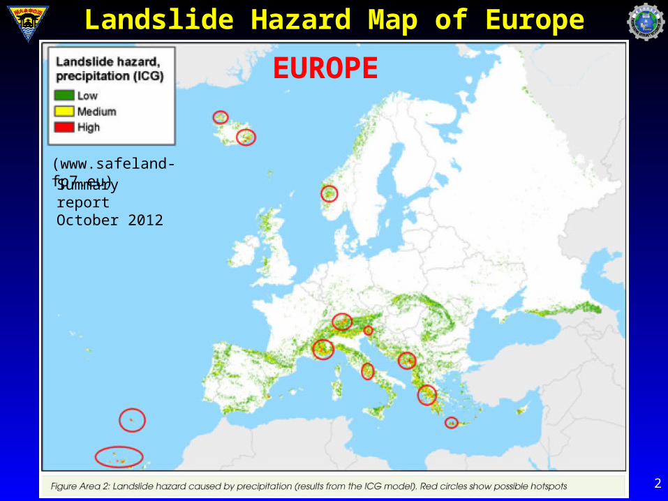
Landslide Hazard Map of Europe
(www.safeland-fp7.eu)
Summary report October 2012
EUROPE
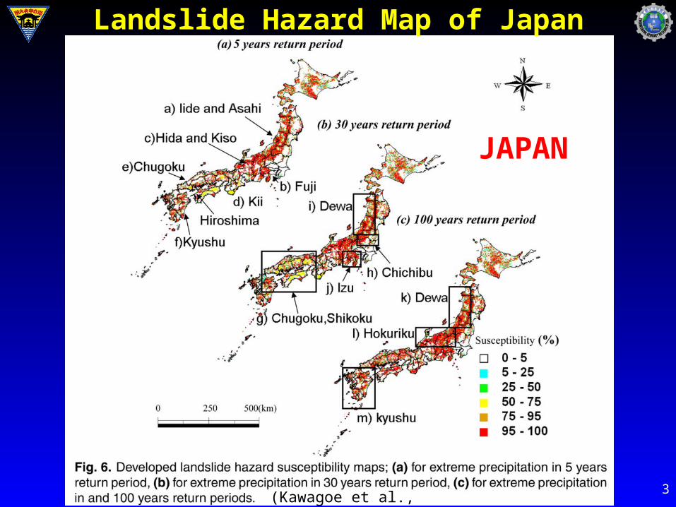
3(Kawagoe et al., 2010)
Landslide Hazard Map of Japan
JAPAN
0.0000
0.0050
0.0100
0.0150
0.0200
0.0250
0 1 3 5 6 7 8 9 10
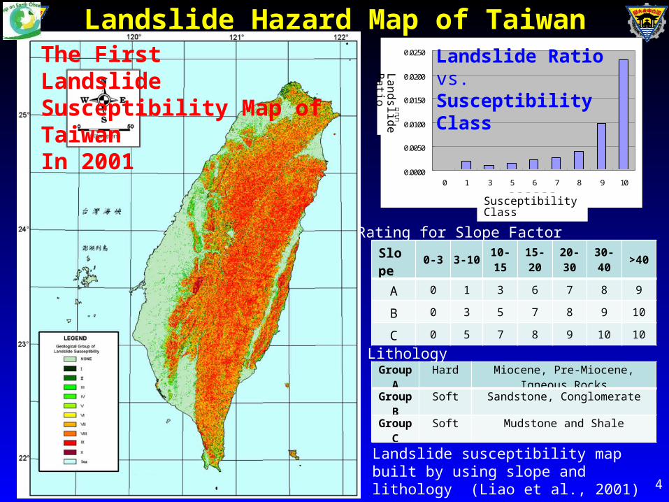
山崩潛感分級
崩壞
比
4
Landslide susceptibility map built by using slope and lithology (Liao et al., 2001)
The First Landslide Susceptibility Map of TaiwanIn 2001
LithologyGroup A Hard Miocene, Pre-Miocene, Igneous Rocks
Group B Soft Sandstone, Conglomerate
Group C Soft Mudstone and Shale
Rating for Slope FactorSlope 0-3 3-10 10-15 15-20 20-30 30-40 >40
A 0 1 3 6 7 8 9
B 0 3 5 7 8 9 10
C 0 5 7 8 9 10 10
Landslide Hazard Map of Taiwan
Susceptibility Class
La
nd
slide
R
atio
Landslide Ratio vs. Susceptibility Class
5
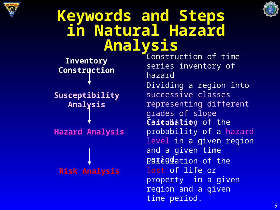
Susceptibility Analysis
Hazard Analysis
Risk Analysis
Inventory Construction Construction of time series inventory of hazard
Dividing a region into successive classes representing different grades of slope instability
Calculation of the probability of a hazard level in a given region and a given time period.
Calculation of the lost of life or property in a given region and a given time period.
Keywords and Steps in Natural Hazard Analysis
6
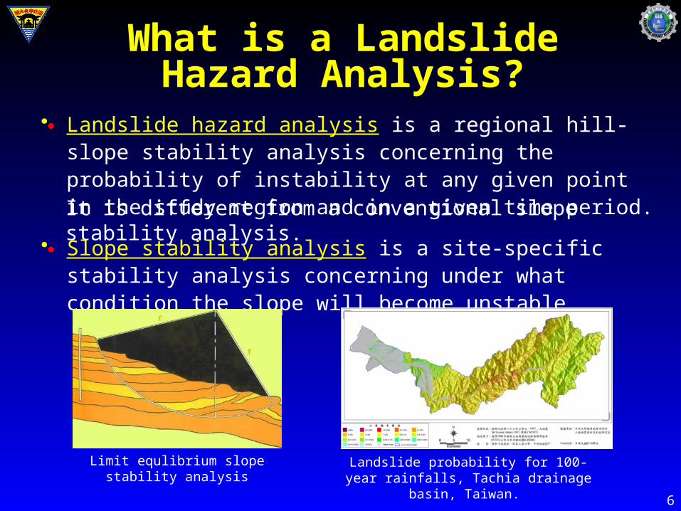
• Landslide hazard analysis is a regional hill-slope stability analysis concerning the probability of instability at any given point in the study region and in a given time period.
What is a Landslide Hazard Analysis?
It is different from a conventional slope stability analysis.
• Slope stability analysis is a site-specific stability analysis concerning under what condition the slope will become unstable.
Landslide probability for 100-year rainfalls, Tachia drainage basin, Taiwan.
Limit equlibrium slope stability analysis
●
●
7
7
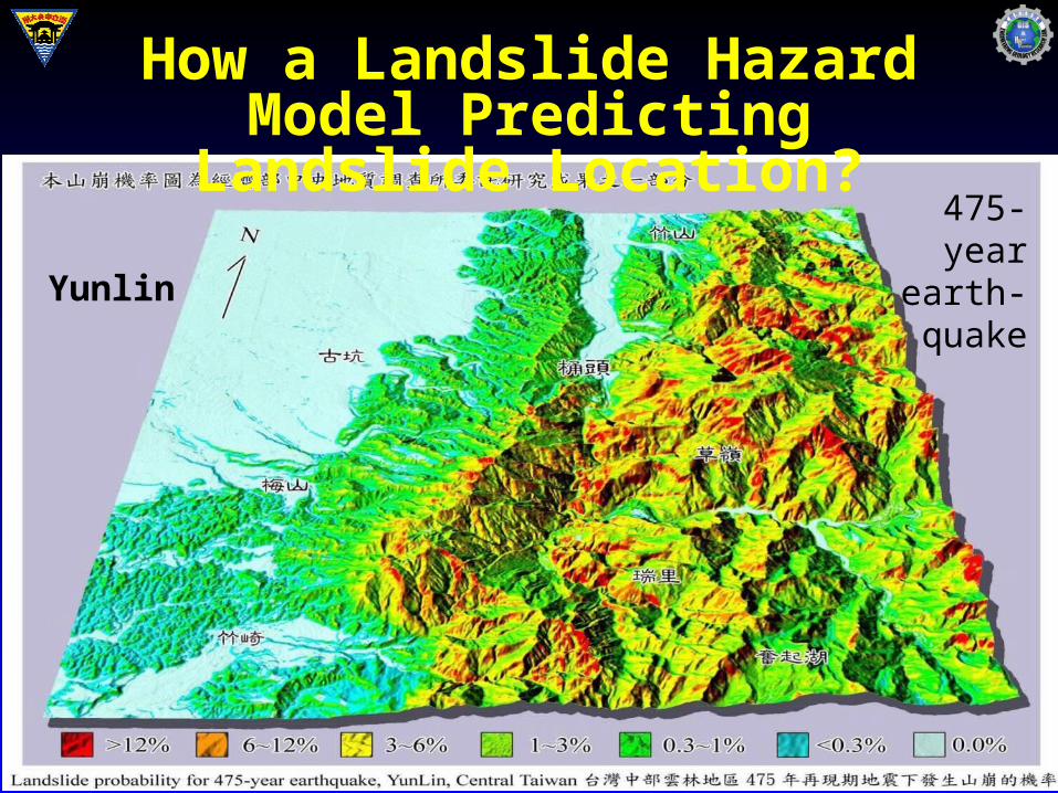
Yunlin
475-year earth-quake
How a Landslide Hazard Model Predicting Landslide Location?
8
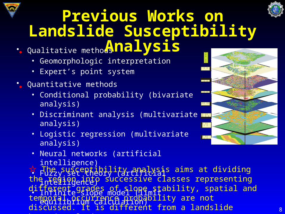
• Qualitative methods• Geomorphologic interpretation• Expert’s point system
• Quantitative methods• Conditional probability (bivariate analysis)• Discriminant analysis (multivariate analysis)• Logistic regression (multivariate analysis)• Neural networks (artificial intelligence)• Fuzzy set theory (artificial intelligence)• Infinite slope model (limit equilibrium calculation)
☆ The susceptibility analysis aims at dividing the region into successive classes representing different grades of slope stability, spatial and temporal occurrence probability are not discussed. It is different from a landslide hazard analysis.
坡 度
岩 性
坡 向
地 表 覆 蓋
距 侵 蝕距 離溝
距 道 路距 離
距 斷 層距 離
山崩
潛感
圖
Previous Works on Landslide Susceptibility Analysis
●
●
9
9
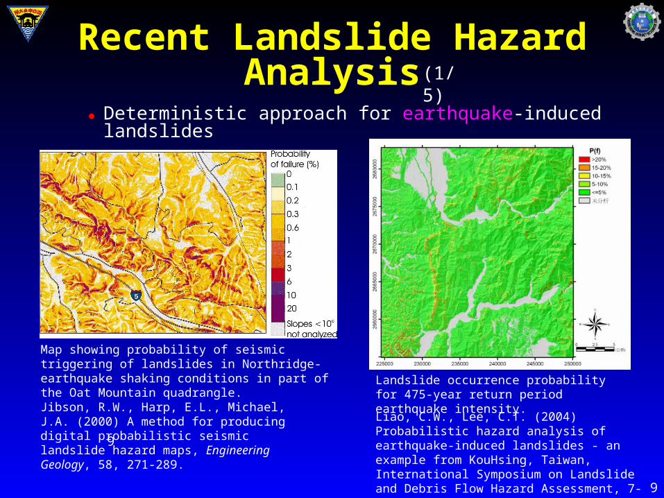
Map showing probability of seismic triggering of landslides in Northridge-earthquake shaking conditions in part of the Oat Mountain quadrangle.
Jibson, R.W., Harp, E.L., Michael, J.A. (2000) A method for producing digital probabilistic seismic landslide hazard maps, Engineering Geology, 58, 271-289.
Landslide occurrence probability for 475-year return period earthquake intensity.
Liao, C.W., Lee, C.T. (2004) Probabilistic hazard analysis of earthquake-induced landslides - an example from KouHsing, Taiwan, International Symposium on Landslide and Debris Flow Hazard Assessment, 7-1~ 7-9.
Recent Landslide Hazard Analysis (1/5)
Deterministic approach for earthquake-induced landslides●
10
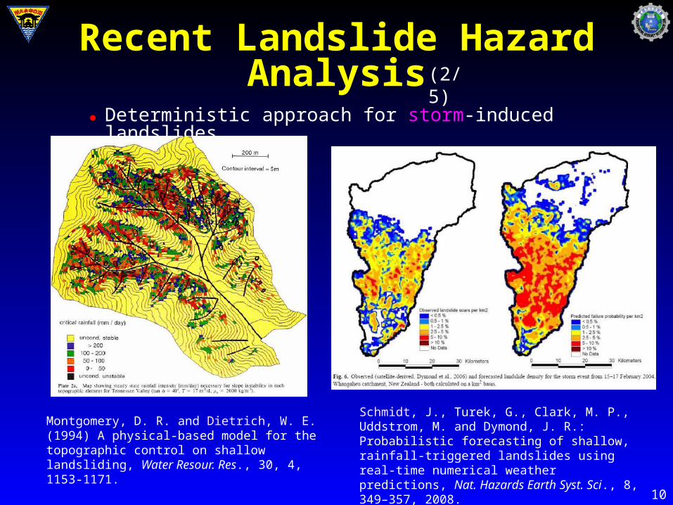
Deterministic approach for storm-induced landslides
Montgomery, D. R. and Dietrich, W. E. (1994) A physical-based model for the topographic control on shallow landsliding, Water Resour. Res., 30, 4, 1153-1171.
Schmidt, J., Turek, G., Clark, M. P., Uddstrom, M. and Dymond, J. R.: Probabilistic forecasting of shallow, rainfall-triggered landslides using real-time numerical weather predictions, Nat. Hazards Earth Syst. Sci., 8, 349–357, 2008.
Recent Landslide Hazard Analysis (2/5)
●
11
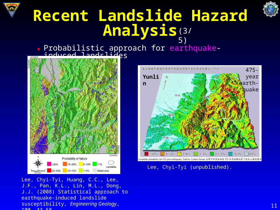
Probabilistic approach for earthquake-induced landslides
Lee, Chyi-Tyi, Huang, C.C., Lee, J.F., Pan, K.L., Lin, M.L., Dong, J.J. (2008) Statistical approach to earthquake-induced landslide susceptibility, Engineering Geology, 100, 43-58.
Yunlin475-year
earth-quake
Lee, Chyi-Tyi (unpublished).
Recent Landslide Hazard Analysis (3/5)
●
12
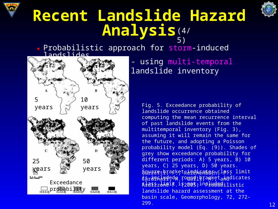
Probabilistic approach for storm-induced landslides
Guzzetti, F., Reichenbach, P., Cardinali, M., Galli, M., and Ardizzone F. (2005) Probabilistic landslide hazard assessment at the basin scale, Geomorphology, 72, 272-299.
Fig. 5. Exceedance probability of landslide occurrence obtained computing the mean recurrence interval of past landslide events from the multitemporal inventory (Fig. 3), assuming it will remain the same for the future, and adopting a Poisson probability model (Eq. (9)). Shades of grey show exceedance probability for different periods: A) 5 years, B) 10 years, C) 25 years, D) 50 years. Square bracket indicates class limit is included; round bracket indicates class limit is not included.
5 years 10 years
50 years25 years
Exceedance probability
- using multi-temporal landslide inventory
Recent Landslide Hazard Analysis (4/5)
●
13
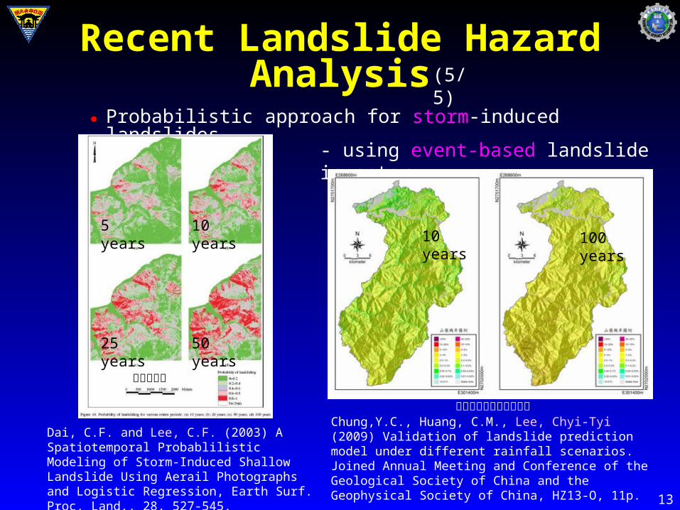
Probabilistic approach for storm-induced landslides
Dai, C.F. and Lee, C.F. (2003) A Spatiotemporal Probablilistic Modeling of Storm-Induced Shallow Landslide Using Aerail Photographs and Logistic Regression, Earth Surf. Proc. Land., 28, 527-545.
Chung,Y.C., Huang, C.M., Lee, Chyi-Tyi (2009) Validation of landslide prediction model under different rainfall scenarios. Joined Annual Meeting and Conference of the Geological Society of China and the Geophysical Society of China, HZ13-O, 11p.
- using event-based landslide inventory
5 years 10 years
50 years25 years
10 years 100 years
香港大嶼山
台灣北部石門水庫集水區
Recent Landslide Hazard Analysis (5/5)
●
14
• Deterministic approach: Limit equilibrium analysis of infinite-slope at a region using strength and hydrologic parameters to obtain a safety factor for a given point under rainfall or earthquake condition.
• Direct probabilistic approach: Using a long-period multi-temporal landslide inventories to analyze the landslide occurrence probability for each slope under certain return period.
• Spatial-Temporal probabilistic approach: To analyze the spatial landslide occurrence probability and the rainfall temporal probability separately. Landslide occurrence probability is obtained via event-based landslide susceptibility analysis. Temporal probability is obtained by hydrological frequency analysis of rainfalls.
Summary of Methods for Landslide Hazard Analysis
●
●
●
15
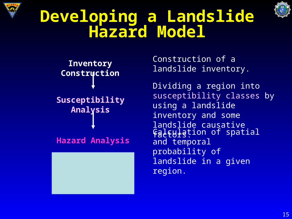
Susceptibility Analysis
Hazard Analysis
Risk Analysis
Inventory Construction Construction of a landslide inventory.
Dividing a region into susceptibility classes by using a landslide inventory and some landslide causative factors.
Calculation of spatial and temporal probability of landslide in a given region.
Developing a Landslide Hazard Model
16
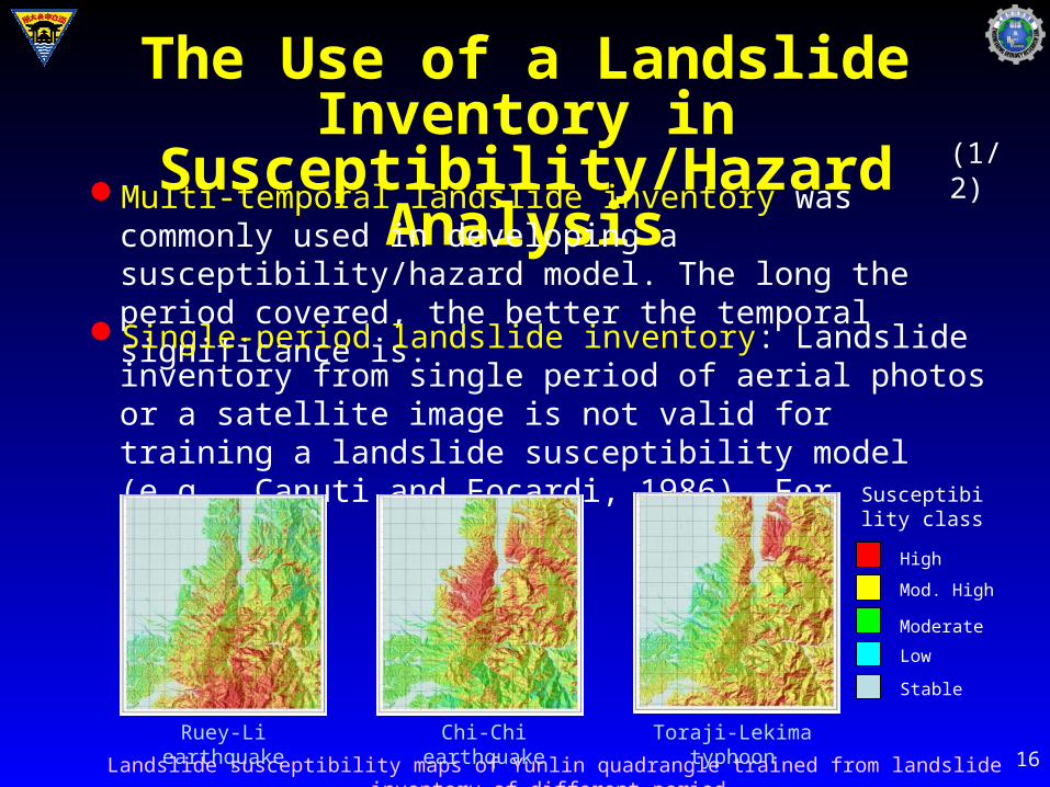
The Use of a Landslide Inventory in Susceptibility/Hazard AnalysisMulti-temporal landslide inventory was commonly used in
developing a susceptibility/hazard model. The long the period covered, the better the temporal significance is.
Single-period landslide inventory: Landslide inventory from single period of aerial photos or a satellite image is not valid for training a landslide susceptibility model (e.g., Canuti and Focardi, 1986). For example,
Ruey-Li earthquake Chi-Chi earthquake Toraji-Lekima typhoon
High
Mod. High
Moderate
Low
Stable
Susceptibility class
Landslide susceptibility maps of Yunlin quadrangle trained from landslide inventory of different period.
(1/2)
17
The Use of a Landslide Inventory in Susceptibility/Hazard Analysis
(2/2)
Single-period landslide inventory for susceptibility analysis is biased. However, it may not be feasible to use a multi-temporal landslide inventory in some regions. This is especially true in Taiwan (Lee and Fei, 2011), and therefore, an event landslide inventory must be considered.
Event landslide inventory is feasible in developing an event-based susceptibility/hazard model (Lee et al., 2008a, 2008b). The temporal significance may come from the triggering factors used in building the model.
18
Landslide Types Considered in Susceptibility/Hazard Analysis
Deep-seated landslides are commonly controlled by local geological structures. They were usually not considered in building a susceptibility/hazard model.
Debris flows are different with slide and fall type of landslides in many aspects, like location and controlling factors. Their susceptibility/hazard analysis was commonly performed along.
Shallow landslides are commonly of random features occurred on hill slope. They were the target in building a susceptibility/hazard model. Rock falls have similar random behavior with shallow landslides. The were usually included in the shallow landslide group for analysis.
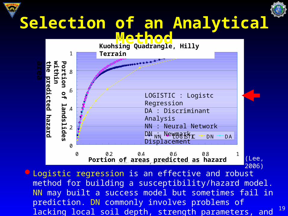
19
Hilly terrain
0
0.2
0.4
0.6
0.8
1
0 0.2 0.4 0.6 0.8 1Portion of areas predicted as hazard area
Por
tion
of
land
slid
es w
ithi
nth
e pr
edic
ted
haza
rd a
rea
NN LOGISTIC DN DA
LOGISTIC : Logistc RegressionDA : Discriminant AnalysisNN : Neural NetworkDN : Newmark Displacement
Kuohsing Quadrangle, Hilly Terrain
123Portion of areas predicted as hazard
Po
rtion
of lan
dslid
es with
in
the p
redicted
hazard
are
a
(Lee, 2006)
Selection of an Analytical Method
Logistic regression is an effective and robust method for building a susceptibility/hazard model. NN may built a success model but sometimes fail in prediction. DN commonly involves problems of lacking local soil depth, strength parameters, and groundwater data.
20
Selection of a Mapping Unit A mapping unit refers to a portion of the land surface which contains a set of ground conditions which differ from the adjacent units across definable boundaries (Hansen, 1984).
Grid-cells, divide the territory into regular squares of pre-defined size.
Terrain units, favored by geomorphologists, are based on the observation that frequently reflect geomorphological and geological differences.
Unique-condition units, are homogeneous domains derived from classification of many slope-instability factors.
Slope-units, automatically derived from high-quality DTMs, partition the territory into hydrological regions between drainage and divide lines.
Topographic units, are further subdivided into homogeneous morphometric domains from the slope units.
●
●
21
Computer Software Needed
Vector GIS: MapInfo, ArcGIS, and others, for mapping of landslides and output of thematic maps.
Image Processing and Raster GIS: Erdas Imagine, and others, for processing of satellite images, and for processing of landslide causative factors from DEM and others.
Statistical Package: SPSS, SAS, MATLAB, and others, for statistical tests and multivariate analysis, like logistic regressing and discriminant analysis.
Others, like Fortran code designed for specific data processing or analysis.
●
●
●
●

22
Thanks for your attention!