Embed Size (px)
Citation preview
1 | B e n
a p o l e - J e s s o r e | T R A N SS P O R T
2 | B e n
Transpo
a p o l e - J
ort Plannin
e s s o r e
T
ng Expert, H
| T R A N S
Fina
Transpo
Mar
Ahs
PreparatioHighway Co
S P O R T
al Repo
On
ort Plan
rch 201
sanul Kabir
on of Develorridor Pro
ort
nning
17
r
lopment Ploject, and
lan for Ben
napole-Jessore
3 | B e n a p o l e - J e s s o r e | T R A N S P O R T
Contents1. Introduction to Development Corridor: ................................................................................... 5
2. Benapole-Jessore Corridor : .................................................................................................... 7
3. Location and Role .................................................................................................................... 9
4. Goals and Objectives ............................................................................................................... 9
5. Assigned Task........................................................................................................................ 10
6. Scope of the Work ................................................................................................................. 10
7. Existing Conditions of Transportation ................................................................................. 10
8. Landuse Transport Interaction and Trend of Traffic ............................................................. 13
9. Issues to Address ................................................................................................................... 15
10. Strategies to address Objectives ......................................................................................... 16
11. Future Plan ......................................................................................................................... 18
11.1. Strategic Connectivity ................................................................................................ 18
11.2. Railway ....................................................................................................................... 23
12. Transport Management Plan .............................................................................................. 24
12.2. Road Hierarchy ........................................................................................................... 24
12.3. Traffic Management ................................................................................................... 24
12.4. Public Transport ......................................................................................................... 25
13. Implementation Strategy .................................................................................................... 25
13.1. Benapole-Jessore Highway ......................................................................................... 26
13.2. Link for External Destination ..................................................................................... 27
13.3. Major Roads | Loop | Parallel Roads .......................................................................... 28
13.4. Service Road ............................................................................................................... 29
13.5. Street Signage and Furniture ...................................................................................... 31
14. Transport Policies .............................................................................................................. 32
15. Conclusion ......................................................................................................................... 33
4 | B e n a p o l e - J e s s o r e | T R A N S P O R T
Q
List of Figures
Figure 1: Concept of Infrastructure Development Corridor (http://www.schillerinstitute.org/economy/maps/maps2.html) ...................................................... 5 Figure 2: Types of Development Corridor (Source: Hope and Cox, 2015) .................................... 6 Figure 3: Evaluation Stage of Development Corridor (Hope and Cox, 2015) ............................... 7 Figure 4: Alignment of Benapole to Padma Bridge Highway (part of AH1) ................................. 8 Figure 5: Existing Transport Network .......................................................................................... 11 Figure 6: Modal Share on Benapole-Jessore Highway ................................................................. 12 Figure 7: Velocity (m/s) of public Bus from Jessore to Benapole ................................................ 13 Figure 8: Settlement Pattern in Benapole-Jessore Corridor .......................................................... 14 Figure 9: Connectivity of Benapole-Jesore Highway ................................................................... 15 Figure 10: Queue of freight lorry .................................................................................................. 17 Figure 11: Proposed connectivity ................................................................................................. 19 Figure 12: Municipal Areas with in Benapole-Jessor corridor ..................................................... 20 Figure 13: Concentration of economic activities .......................................................................... 21 Figure 14: Proposed Urban Developoment Strategy .................................................................... 22 Figure 15: Proposed Road Hierarchy for the Corridor ................................................................. 23 Figure 16: Conceptual lanning of Benapole-Jessore Highway ..................................................... 26 Figure 17: Plan of the proposed Highway .................................................................................... 27 Figure 18: Proposed improvement of external links ..................................................................... 28 Figure 19: Proposed road hierarchy .............................................................................................. 29 Figure 20: Service Road................................................................................................................ 30 Figure 21: Bus bay ....................................................................................................................... 31
5 | B e n a p o l e - J e s s o r e | T R A N S P O R T
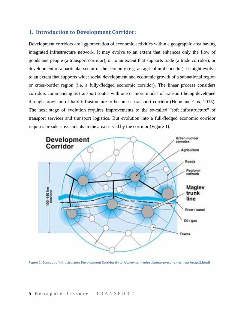
1. IntroductiontoDevelopmentCorridor:
Development corridors are agglomeration of economic activities within a geographic area having
integrated infrastructure network. It may evolve to an extent that enhances only the flow of
goods and people (a transport corridor), or to an extent that supports trade (a trade corridor), or
development of a particular sector of the economy (e.g. an agricultural corridor). It might evolve
to an extent that supports wider social development and economic growth of a subnational region
or cross-border region (i.e. a fully-fledged economic corridor). The linear process considers
corridors commencing as transport routes with one or more modes of transport being developed
through provision of hard infrastructure to become a transport corridor (Hope and Cox, 2015).
The next stage of evolution requires improvements to the so-called “soft infrastructure” of
transport services and transport logistics. But evolution into a full-fledged economic corridor
requires broader investments in the area served by the corridor (Figure 1).
Figure 1: Concept of Infrastructure Development Corridor (http://www.schillerinstitute.org/economy/maps/maps2.html)
6 | B e n
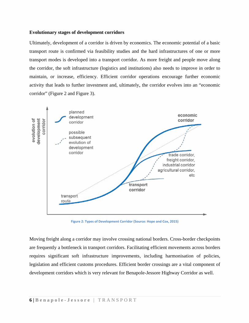
Evolutio
Ultimate
transport
transport
the corrid
maintain
activity t
corridor”
Moving f
are frequ
requires
legislatio
developm
a p o l e - J
onary stages
ly, developm
t route is co
t modes is d
dor, the soft
, or increas
that leads to
” (Figure 2 a
freight along
uently a bottl
significant
on and effici
ment corrido
e s s o r e
s of developm
ment of a cor
onfirmed via
developed int
t infrastructu
se, efficienc
further inve
nd Figure 3)
Figure 2: Types
g a corridor m
leneck in tra
soft infras
ent customs
rs which is v
| T R A N S
ment corrid
rridor is driv
a feasibility
to a transpo
ure (logistics
cy. Efficient
estment and
).
s of Developmen
may involve
ansport corrid
tructure im
s procedures
very relevan
S P O R T
dors
ven by econo
studies and
rt corridor.
s and institu
t corridor o
, ultimately,
nt Corridor (Sou
e crossing na
dors. Facilita
mprovements,
. Efficient b
nt for Benapo
omics. The e
the hard in
As more fre
utions) also n
operations e
, the corrido
urce: Hope and C
ational borde
ating efficien
, including
border crossi
ole-Jessore H
economic po
nfrastructures
eight and pe
needs to imp
encourage f
or evolves in
Cox, 2015)
ers. Cross-bo
nt movemen
harmonisat
ings are a vi
Highway Co
otential of a
s of one or
eople move a
prove in ord
further econ
nto an “econ
order checkp
nts across bo
tion of pol
ital compone
rridor as we
basic
more
along
der to
nomic
nomic
points
orders
licies,
ent of
ell.
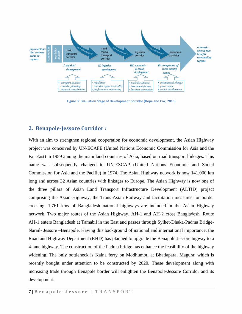
7 | B e n
2. Ben
With an
project w
Far East)
name w
Commiss
long and
the three
comprisin
crossing.
network.
AH-1 ent
Narail- J
Road and
4-lane hi
widening
recently
increasin
developm
a p o l e - J
F
napole‐Jes
aim to stren
was conceive
) in 1959 am
was subsequ
sion for Asia
d across 32 A
e pillars o
ng the Asia
1,761 kms
Two major
ters Banglad
essore –Ben
d Highway D
ghway. The
g. The only
bought und
ng trade thro
ment.
e s s o r e
Figure 3: Evaluat
ssoreCorr
ngthen regio
ed by UN-EC
mong the ma
uently chang
a and the Pa
Asian countr
f Asian La
an Highway,
s of Bangla
r routes of t
desh at Tama
napole. Havin
Department (
construction
bottleneck i
der attention
ough Benapo
| T R A N S
tion Stage of De
ridor:
nal cooperat
CAFE (Unit
in land coun
ged to UN
acific) in 197
ries with link
and Transp
, the Trans-A
adesh nation
the Asian H
abil in the E
ng this back
(RHD) has p
n of the Padm
is Kalna fer
n to be con
ole border w
S P O R T
evelopment Corr
tion for econ
ted Nations
ntries of Asi
N-ESCAP (U
74. The Asia
kages to Eur
ort Infrastru
Asian Railw
nal highway
Highway, AH
ast and pass
kground of n
planned to u
ma bridge h
rry on Modh
nstructed by
will enlighte
ridor (Hope and
nomic devel
Economic C
a, based on
United Nati
an Highway
rope. The A
ructure Dev
way and faci
ys are inclu
H-1 and AH
ses through S
national and
upgrade the B
has enhance t
humoti at B
y 2020. The
n the Benap
d Cox, 2015)
lopment, the
Commission
road transpo
ions Econo
y network is
Asian Highw
velopment (
ilitation mea
uded in the
H-2 cross Ba
Sylhet-Dhak
internationa
Benapole Jes
the feasibilit
Bhatiapara, M
ese developm
pole-Jessore
e Asian High
n for Asia an
ort linkages.
omic and S
now 141,00
way is now o
(ALTID) pr
asures for b
Asian High
angladesh. R
ka-Padma Br
al importance
ssore higway
ty of the high
Magura; whi
ment along
Corridor an
hway
nd the
. This
Social
00 km
one of
roject
border
hway
Route
ridge-
e, the
y to a
hway
ich is
with
nd its
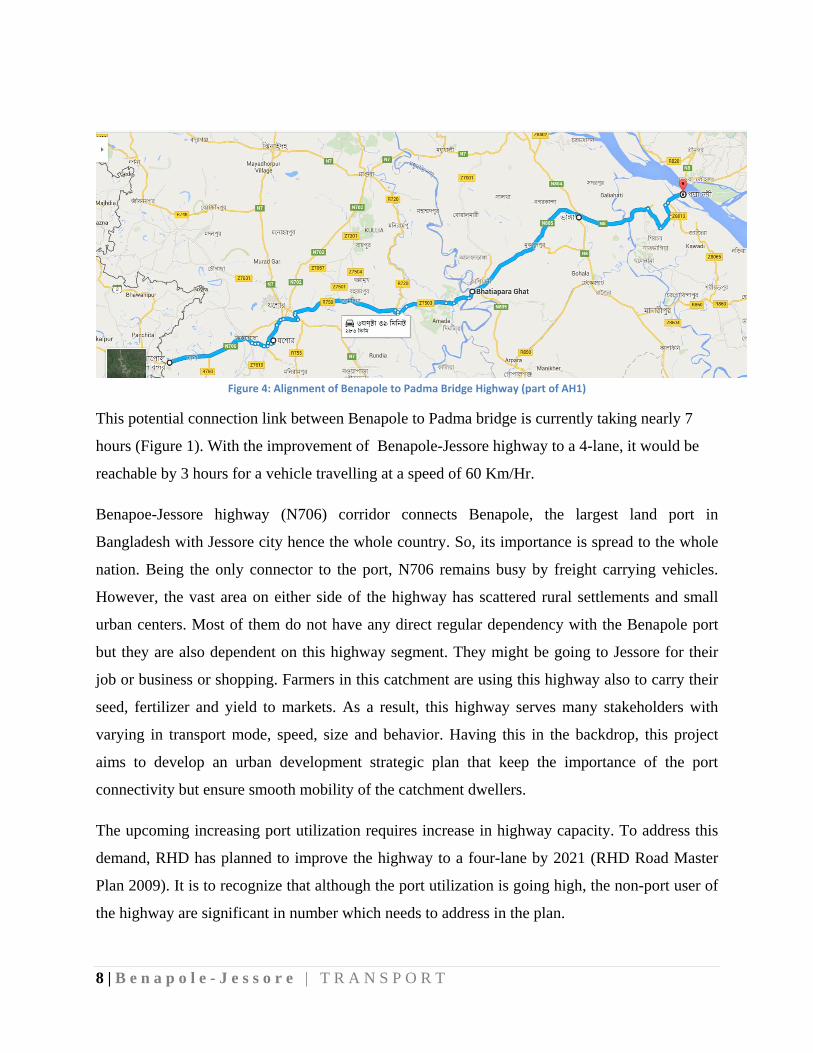
8 | B e n a p o l e - J e s s o r e | T R A N S P O R T
Figure 4: Alignment of Benapole to Padma Bridge Highway (part of AH1)
This potential connection link between Benapole to Padma bridge is currently taking nearly 7
hours (Figure 1). With the improvement of Benapole-Jessore highway to a 4-lane, it would be
reachable by 3 hours for a vehicle travelling at a speed of 60 Km/Hr.
Benapoe-Jessore highway (N706) corridor connects Benapole, the largest land port in
Bangladesh with Jessore city hence the whole country. So, its importance is spread to the whole
nation. Being the only connector to the port, N706 remains busy by freight carrying vehicles.
However, the vast area on either side of the highway has scattered rural settlements and small
urban centers. Most of them do not have any direct regular dependency with the Benapole port
but they are also dependent on this highway segment. They might be going to Jessore for their
job or business or shopping. Farmers in this catchment are using this highway also to carry their
seed, fertilizer and yield to markets. As a result, this highway serves many stakeholders with
varying in transport mode, speed, size and behavior. Having this in the backdrop, this project
aims to develop an urban development strategic plan that keep the importance of the port
connectivity but ensure smooth mobility of the catchment dwellers.
The upcoming increasing port utilization requires increase in highway capacity. To address this
demand, RHD has planned to improve the highway to a four-lane by 2021 (RHD Road Master
Plan 2009). It is to recognize that although the port utilization is going high, the non-port user of
the highway are significant in number which needs to address in the plan.
9 | B e n a p o l e - J e s s o r e | T R A N S P O R T
3. LocationandRoleBangladesh has a significant advantage in term of geographical location within the South Asian
region and has every possibility to become a regional hub with utilizing the opportunity through
regional connectivity. It is a general argument that Bangladesh should situate the issue of Indo-
Bangladesh transit in a broader regional context associated with the commitment of Bangladesh
Government to the establishment of an Asian Highway and Railway. Large investment is to be
needed to improve the road and rail system of Bangladesh for inducing this establishment. There
will be needed massive investment not only in road, rail and riverine infrastructure but also in
transit traffic if Bangladesh is to even approximate her aspirations to graduate to middle income
country by 2021.
Benapole is located in Jessore district, one of oldest district in Bangladesh. Jessore Paurashava is
the largest hub of trade and commerce in this region. Land Port at Beanpole with appropriate
transit services, transport and rail facilities alone with the development of existing road and rail
infrastructure up to Jessore having modern river-port facility at Jhikargachha will be a first step
to accomplish its vision 2021 as a middle income nation. Port facility development projects must
be consistent with national development plans and relevant local development plans. In general,
development requires a significant period of time and influences significant areas of the country.
Regional transport networks and socio-economic activities must be taken into consideration
when developing the facilities.
4. GoalsandObjectives
This project aims to prepare a Development Plan for Benapole Municipality & Land Port area,
Sharsha & Jhikargachha Upazila Town and Jessore District Town along with the Jessore-
Benapole Highway Corridor namely ‘Development Plan for Jessore-Benapole Corridor’ project.
Development Plan for Jessore-Benapole Corridor aims to achieve the following objectives:
i. Transformation of National policies at Jessore-Benapole highway corridor.
ii. Formulation and Integration of different sectoral strategies for Jessore-Benapole highway
corridor.
iii. Spatial interpretation of sectoral strategies for Jessore-Benapole highway corridor.
10 | B e n a p o l e - J e s s o r e | T R A N S P O R T
iv. Formulation of Conservation Plan, Development Plan and Development Control Plan for
Jessore-Benapole highway corridor.
5. AssignedTask
Major tasks for transportation sector are:
i. To study the existing transportation system of the region
ii. To prepare guidelines for improved transport system, affordable to the people
iii. To study the existing land port
iv. Prepare land use matrix and land use planning guidelines for the highway corridor
6. ScopeoftheWorkWithin the outcome of ‘Development Plan for Jessore-Benapole Corridor’ project, there is
immense opportunity to develop the area as an economic zone keeping Benapole port as the hub.
This project has been given emphasis on the existing land port facility at Benapole so that it
could be upgraded with more efficiency. These require improvement in current rail and road plan
integrated with surrounding landuse planning. In addition, this project wants to develop
guidelines for insuring that Jessore would be and should be the main administrative hub of
national and international communication network having road, rail, river and air network at a
single point whereas Nabharan and Jhikargachha, both could have possibilities to become a
national level multi--modal transportation hub where road, rail and river have integrated
together.
7. ExistingConditionsofTransportation
Beanpole and Jessore is connected both by rail and road. Several local markets along this
highway route have become hub for business. The north and southern connections from this
highway ensure access to scattered settlements across the whole landscape. From travel behavior
11 | B e n a p o l e - J e s s o r e | T R A N S P O R T
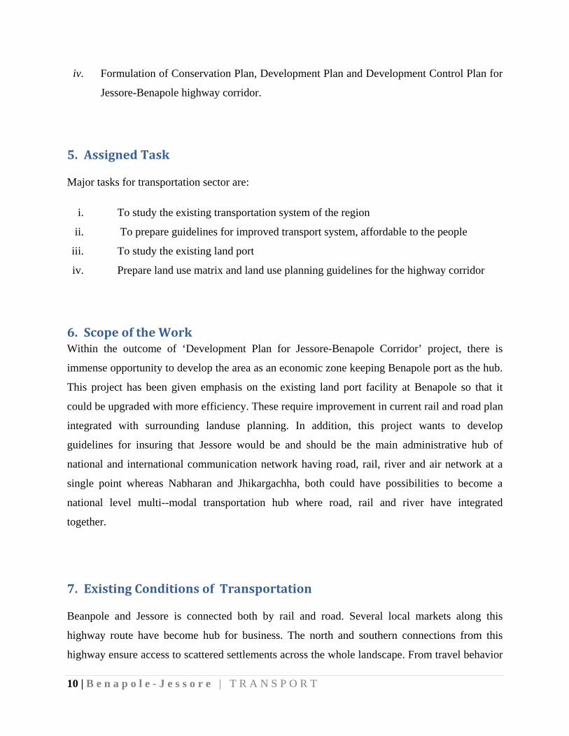
analysis it becomes evident that people from all corners of this corridor depend on this highway
or its segment to commute to work or to travel to education institutes. Along with this, this
corridor is the sole transport link to connect Benapole land port with the rest of the country. As a
result, the highway (N706) is busy for the significant portion of the day. This highway (N706) is
connected to several local roads causing numerous intersection on it which often hamper its
efficiency to act as a major export-import corridor (Figure 5).
Figure 5: Existing Transport Network
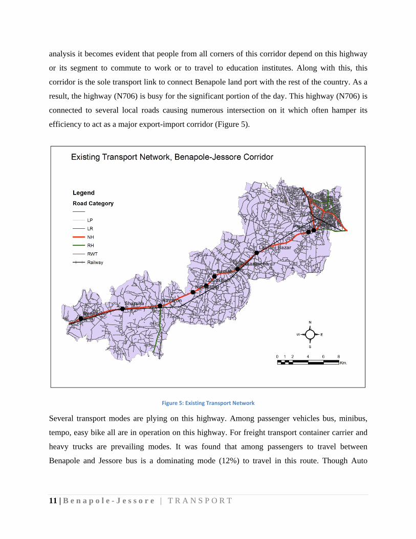
Several transport modes are plying on this highway. Among passenger vehicles bus, minibus,
tempo, easy bike all are in operation on this highway. For freight transport container carrier and
heavy trucks are prevailing modes. It was found that among passengers to travel between
Benapole and Jessore bus is a dominating mode (12%) to travel in this route. Though Auto
12 | B e n
rickshaw
trips and
For freig
bus, min
passenge
rickshaw
trip (Figu
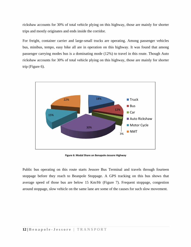
Public b
stoppage
average
around st
n a p o l e - J
w accounts fo
mostly orig
ght, containe
nibus, tempo
er carrying m
w accounts fo
ure 6).
us operating
before the
speed of th
toppage, slow
15%
J e s s o r e
or 30% of to
inates and en
er carrier an
o, easy bike
modes bus is
or 30% of to
Figure
g on this ro
y reach to
hose bus are
w vehicle on
22%
| T R A N
otal vehicle p
nds inside th
nd large-sma
all are in o
s a dominatin
otal vehicle p
e 6: Modal Share
oute starts J
Beanpole S
e below 15
n the same la
30
N S P O R T
plying on th
he corridor.
all trucks ar
peration on
ng mode (12
plying on th
e on Benapole‐J
Jessore Bus
Stoppage. A
Km/Hr (Fi
ane are some
18%
0%
his highway,
re operating
this highwa
2%) to trave
his highway,
Jessore Highway
Terminal a
A GPS track
gure 7). Fre
e of the caus
12%
3%
, those are m
. Among pa
ay. It was fo
el in this rou
, those are m
y
and travels
king on this
equent stopp
ses for such
Truck
Bus
Car
Auto Rick
Motor Cy
NMT
mainly for sh
assenger veh
found that am
ute. Though
mainly for sh
through fou
s bus shows
page, conge
slow movem
kshaw
ycle
horter
hicles
mong
Auto
horter
urteen
s that
estion
ment.
13 | B e n a p o l e - J e s s o r e | T R A N S P O R T
0
2
4
6
8
10
12
14
16 Velocity
8. LanduseTransportInteractionandTrendofTraffic
Landuse and transport has a well-recognized reciprocal relationship. Nature of traffic on a road
largely depend on the landuse and its intensity of the places it connects and its surrounding
landuse that have access to it. Along with port-city connection, this highway connects several
growth centres. This results movement of raw materials to farms and yields to market through it.
For local agriculture commodity transport generally smaller truck, sometimes even locally made
vehicles are used. On the contrary, export-import items from port used heavy duty large truck.
Again, there is a heterogeneous mix of passengers’ vehicles including NMT. All these traffic mix
creates a slow flow on the road.
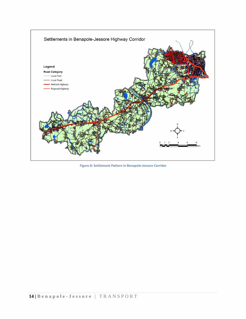
Figure 8 clearly shows that most settlements are clustered beside the road which is a common
scenario for any unplanned area. The same trend can be used as a guiding principle for area
development. It is found that without much development control a road can be a good trigger for
development. Development refers here construction of buildings for residential or commercial
purposes. So it is suggested that zoning must be defined as a corner stone of urban development
strategy for this area. These zones are then connected to each other and a hierarchy of transport
network is established.
Figure 7: Velocity (m/s) of public Bus from Jessore to Benapole
14 | B e n a p o l e - J e s s o r e | T R A N S P O R T
Figure 8: Settlement Pattern in Benapole‐Jessore Corridor
15 | B e n
9. Issu O
ro
M
P
L
T
n
N
U
al
C
While be
n a p o l e - J
uestoAddOnly two lane
oads and cau
Movement of
ublic transpo
Lack of bus-b
Too many op
ational highw
No effective r
Uncontrolled
ll are practic
Congestion o
earing on the
J e s s o r e
Figur
dresse highway. I
use congestio
f heterogene
ort service is
bay or stoppa
ening to nat
way
road hierarch
traffic move
ced.
n important
e above ment
| T R A N
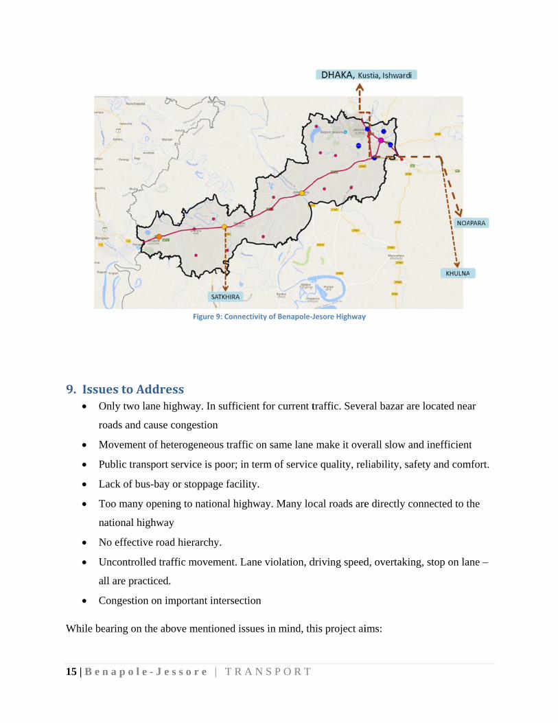
re 9: Connectivit
In sufficient
on
ous traffic o
s poor; in ter
age facility.
ional highwa
hy.
ement. Lane
intersection
tioned issues
N S P O R T
ty of Benapole‐J
for current t
on same lane
rm of service
ay. Many lo
e violation, d
n
s in mind, th
Jesore Highway
traffic. Seve
make it ove
e quality, rel
cal roads are
driving speed
his project ai
y
ral bazar are
erall slow an
liability, saf
e directly co
d, overtaking
ims:
e located nea
nd inefficient
fety and com
onnected to th
g, stop on lan
ar
t
mfort.
he
ne –
16 | B e n a p o l e - J e s s o r e | T R A N S P O R T
to ensure efficient, safe and environmentally sustainable movement of freight and
passenger along this corridor
Ensuring access for local habitat to:
- employment
- schools / colleges
- community facilities
to provide access to market for agriculture practices
reduce dependency of local residents on the N706 for local purpose (school, shopping
etc)
10. StrategiestoaddressObjectives
The Government of Bangladesh has taken several initiatives to enhance connectivity around
Benapole land port. ADB’s technical assistance for Benapole-Jessore highway’s feasibility study
and detailed design for a planned upgrade of the whole 38-kilometer is one of them. It is set to
inject more than BDT 3.29 billion ($42.05 million) to fund the Indo-Bangladesh transport
corridor improvement to facilitate trade and connectivity (SASEC, 2016).
According to the plan, the highway will be upgraded following international standards to better
accommodate heavy vehicles. The project is set to be completed by December 2019. The plan
has been submitted to the Bangladesh Ministry of Road Transport and Bridges for approval. The
highway is central to several regional connectivity initiatives, including the Bangladesh-Bhutan-
India-Nepal Motor Vehicle Agreement, BIMSTEC road corridors, SAARC highway corridors,
and SASEC road corridors.
17 | B e n
Almost 9
border of
Benapole
passenge
At the sa
the either
low in n
cross-hig
density a
free flow
Key strat
E
n a p o l e - J
90% of total
f Benapole,
e border is
ers are distrib
ame time, the
r side of the
number, they
ghway small
and dispersed
w of traffic a
tegies and m
Ensure free fl
o Wide
o Provi
o Provi
J e s s o r e
goods impo
Bangladesh
Kolkata, a
buted to regi
ere is a cultu
e corridor. Si
y are located
trip causing
d all around
and freight w
mode of imple
low on Bena
ening the hig
ision of serv
ision of sepa
| T R A N
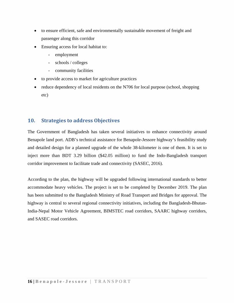
Figure 10: Q
orted to Bang
h, and Petrap
major com
ional market
urally rich an
ince, urban
d on the bot
g disruption t
d. Having the
without caus
ementations
apole-Jessore
ghway to six
vice road at i
arate lane for
N S P O R T
Queue of freigh
gladesh from
pole, India.
mmercial hu
ts and nation
nd agricultu
services (sch
th side of th
to long dista
ese backgrou
ing any neg
are:
e Highway (
x lane
intersection
r light vehic
t lorry
m India pass
Only 80 kil
ub in India.
nal market.
ure wise imp
hool, college
he highway.
ance freight.
und, the mai
gative impac
(N706).
cle at grade
s through the
lometers fro
. The incom
ortant landsc
e, shopping,
. This has c
These settle
in strategy i
ct on people’
e land port o
om the Petra
ming freight
cape is sprea
, hospital etc
created enorm
ements are lo
is taken to en
’s life and li
on the
apole-
t and
ad on
c) are
mous
ow in
nsure
iving.
18 | B e n a p o l e - J e s s o r e | T R A N S P O R T
o Traffic management
Provide local major road for local mobility (parallel and loop) by widening existing road
and new road in case it is needed to complete the loop.
Ensure access to distant locality to allow development to penetrate.
Provide micro link and enhance links in the city to enhance connectivity
11. FuturePlan
Future plan of this area must be a coordinated effort among urban development, infrastructure
development, growth centres, landuse and nature of economic activities.
11.1. StrategicConnectivity
The strategic importance of this corridor reach to a wider geography of Bangladesh. It is an
evident that business and activities around beanpole will increase, hence traffic. One of the
challenge for the planners to divert these traffic to its destination through Jessore.
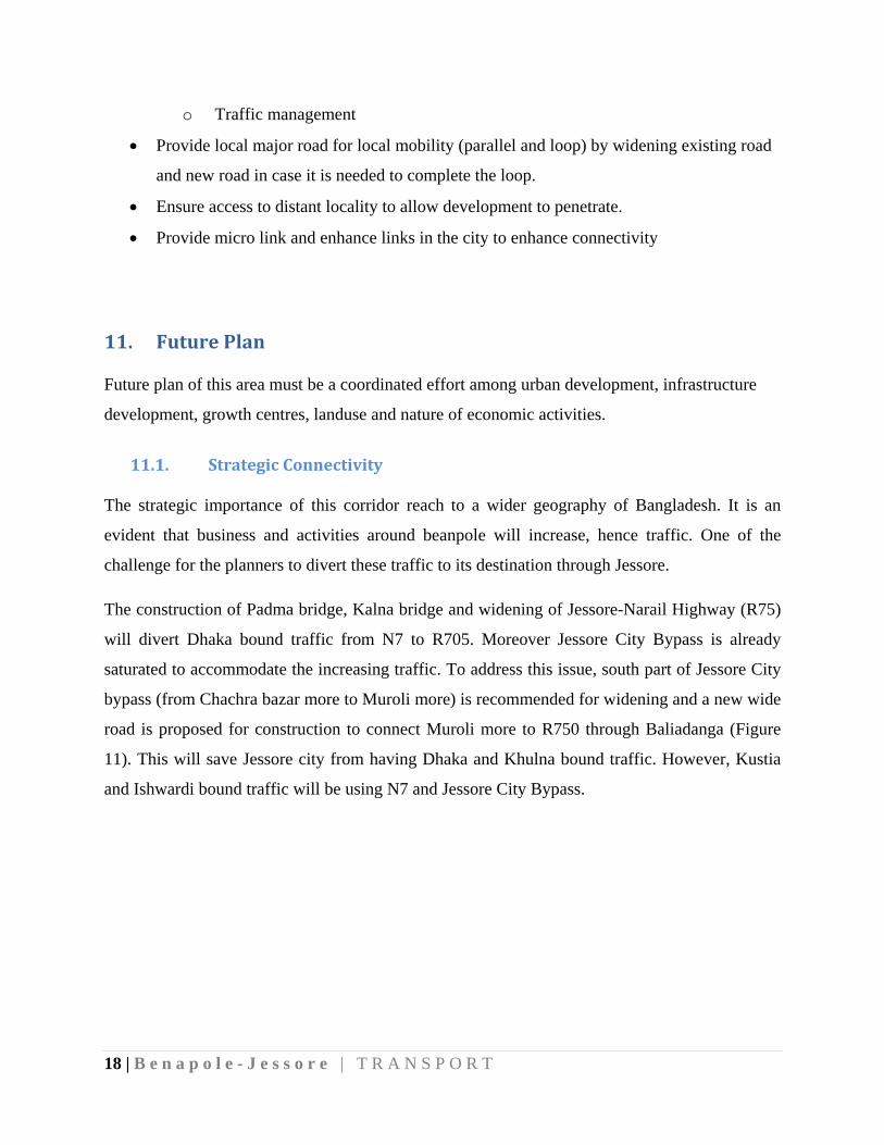
The construction of Padma bridge, Kalna bridge and widening of Jessore-Narail Highway (R75)
will divert Dhaka bound traffic from N7 to R705. Moreover Jessore City Bypass is already
saturated to accommodate the increasing traffic. To address this issue, south part of Jessore City
bypass (from Chachra bazar more to Muroli more) is recommended for widening and a new wide
road is proposed for construction to connect Muroli more to R750 through Baliadanga (Figure
11). This will save Jessore city from having Dhaka and Khulna bound traffic. However, Kustia
and Ishwardi bound traffic will be using N7 and Jessore City Bypass.
19 | B e n
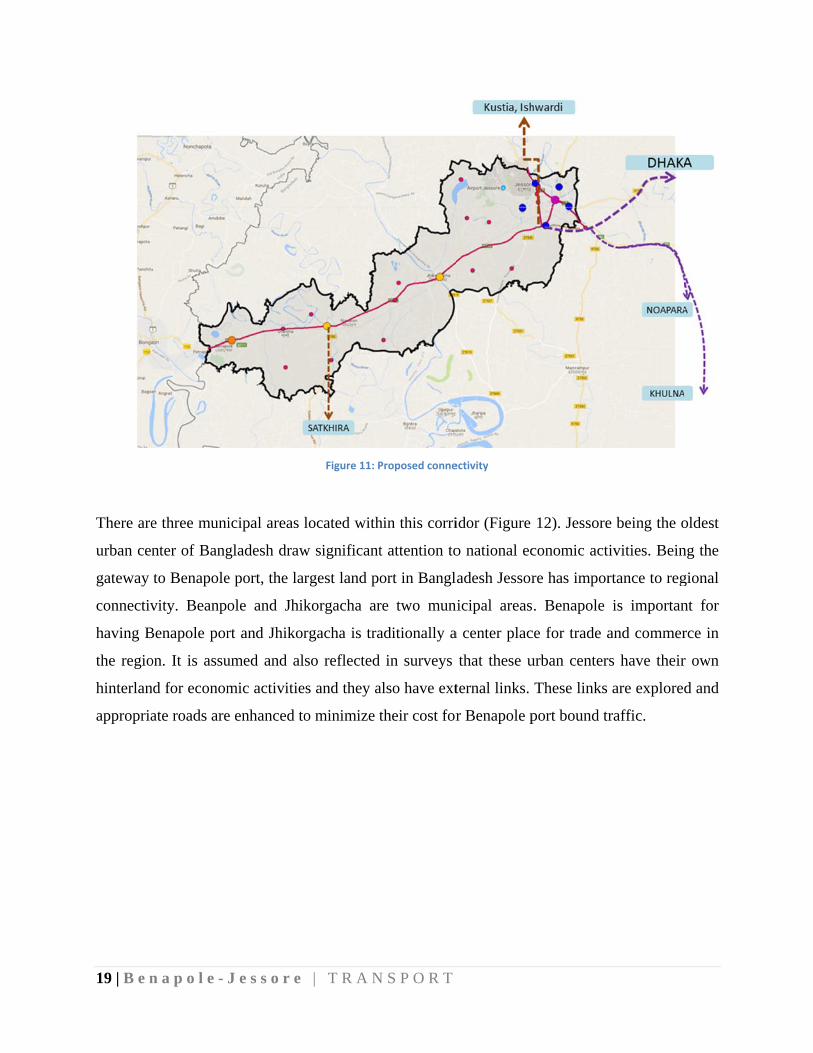
There are
urban cen
gateway
connectiv
having B
the regio
hinterlan
appropria
n a p o l e - J
e three muni
nter of Bang
to Benapole
vity. Beanpo
Benapole por
on. It is assu
nd for econom
ate roads are
J e s s o r e
icipal areas
gladesh draw
e port, the lar
ole and Jhik
rt and Jhikor
umed and al
mic activitie
e enhanced to
| T R A N
Figure 11: P
located with
w significant
rgest land po
korgacha ar
rgacha is tra
so reflected
es and they a
o minimize t
N S P O R T
Proposed conne
hin this corri
t attention to
ort in Bangl
re two mun
aditionally a
in surveys
also have ext
their cost for
ectivity
idor (Figure
o national ec
adesh Jessor
nicipal areas
a center plac
that these u
ternal links.
r Benapole p
12). Jessore
conomic act
re has impor
. Benapole
ce for trade a
urban center
These links
port bound tr
e being the o
ivities. Bein
rtance to reg
is importan
and commer
rs have their
are explored
raffic.
oldest
ng the
gional
nt for
rce in
r own
d and
20 | B e n a p o l e - J e s s o r e | T R A N S P O R T
Figure 12: Municipal Areas with in Benapole‐Jessor corridor
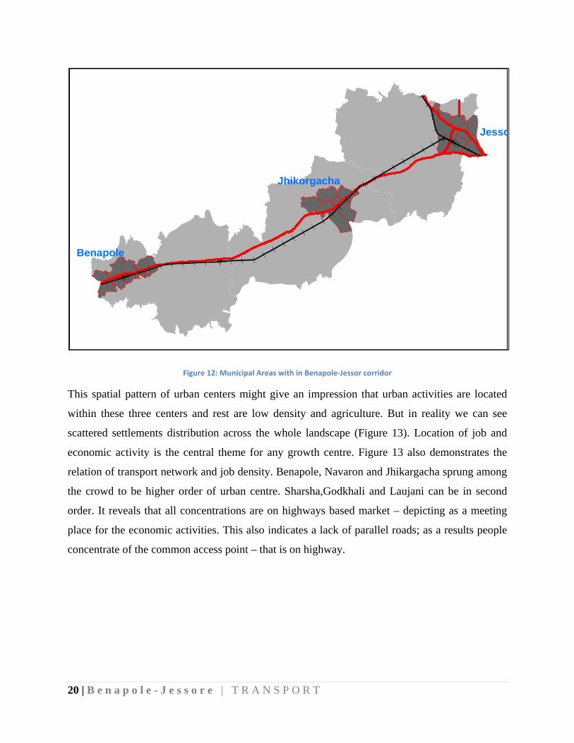
This spatial pattern of urban centers might give an impression that urban activities are located
within these three centers and rest are low density and agriculture. But in reality we can see
scattered settlements distribution across the whole landscape (Figure 13). Location of job and
economic activity is the central theme for any growth centre. Figure 13 also demonstrates the
relation of transport network and job density. Benapole, Navaron and Jhikargacha sprung among
the crowd to be higher order of urban centre. Sharsha,Godkhali and Laujani can be in second
order. It reveals that all concentrations are on highways based market – depicting as a meeting
place for the economic activities. This also indicates a lack of parallel roads; as a results people
concentrate of the common access point – that is on highway.
Benapole
Jhikorgacha
Jesso
21 | B e n a p o l e - J e s s o r e | T R A N S P O R T
Figure 13: Concentration of economic activities
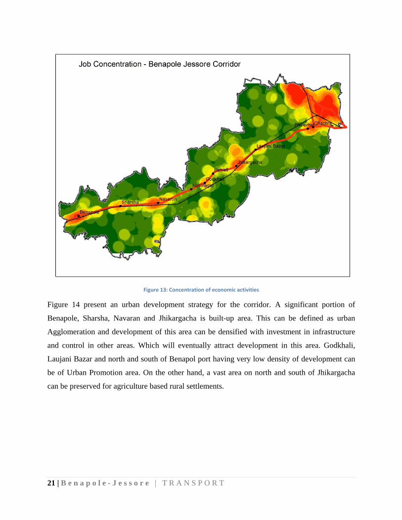
Figure 14 present an urban development strategy for the corridor. A significant portion of
Benapole, Sharsha, Navaran and Jhikargacha is built-up area. This can be defined as urban
Agglomeration and development of this area can be densified with investment in infrastructure
and control in other areas. Which will eventually attract development in this area. Godkhali,
Laujani Bazar and north and south of Benapol port having very low density of development can
be of Urban Promotion area. On the other hand, a vast area on north and south of Jhikargacha
can be preserved for agriculture based rural settlements.

22 | B e n a p o l e - J e s s o r e | T R A N S P O R T
Figure 14: Proposed Urban Developoment Strategy
Road connectivity of these zones will be required at varying scale and certainly of different
densities. For example, rural settlements will require a lesser road density but a firm connectivity
with main roads/highways. But urban agglomeration will require more roads to ensure the use of
all area of the zones without creating much pressure on roadside land.
To promote urban agglomeration, accessibility is to ensure and local roads network is to
complete. It is an idea to connect an urban growth centre with a major road (level 1) which can
ensure quick access. However, land acquisition for such wide road can be a major hindrance and
expensive to implement. In that case, those roads can be selected which has wide right of way
(ROW) to expand. Figure 15 identifies are road alignment that can be improved. Existence roads
are considered with highest degree of importance and in few cases new roads are proposed
realizing the challenges for land acquisition.
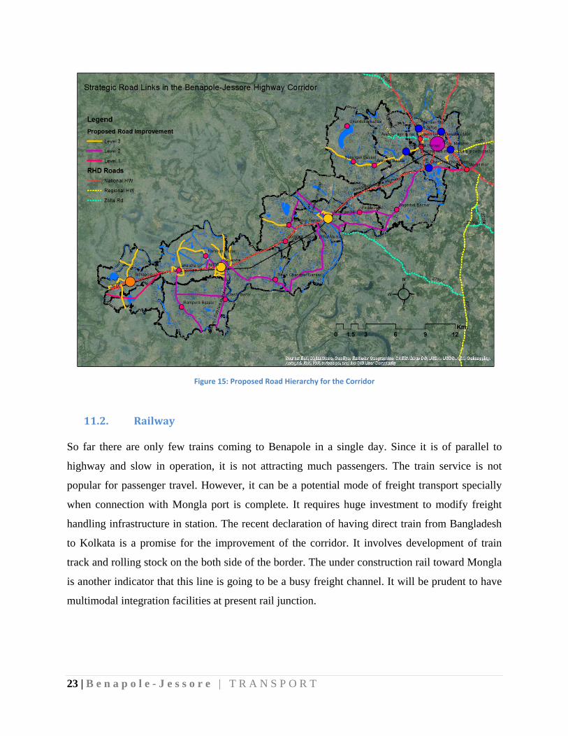
23 | B e n a p o l e - J e s s o r e | T R A N S P O R T
Figure 15: Proposed Road Hierarchy for the Corridor
11.2. Railway
So far there are only few trains coming to Benapole in a single day. Since it is of parallel to
highway and slow in operation, it is not attracting much passengers. The train service is not
popular for passenger travel. However, it can be a potential mode of freight transport specially
when connection with Mongla port is complete. It requires huge investment to modify freight
handling infrastructure in station. The recent declaration of having direct train from Bangladesh
to Kolkata is a promise for the improvement of the corridor. It involves development of train
track and rolling stock on the both side of the border. The under construction rail toward Mongla
is another indicator that this line is going to be a busy freight channel. It will be prudent to have
multimodal integration facilities at present rail junction.
24 | B e n a p o l e - J e s s o r e | T R A N S P O R T
12. TransportManagementPlan
Transport management of this corridor have components:
i) To ensure easy movement for freight and passenger from and to port
ii) Connecting small, local settlement to provide access to education, business, health
and other urban services
iii) Facilitate local economic activities (mostly agriculture based).
It is suggested that spatial zoning is made to demark area for future urban development. Facilities
and services will be located in those zones and other areas are expected to experience no urban
development. These require strong presence of urban governance and implementation of physical
plans.
12.2. RoadHierarchy
At first, a road hierarchy is to establish followed by an urban hierarchy. In proposed hierarchy:
Level-I roads will connect growth centres on highway with clusters of business and
settlements
Only level I roads will connects the highway
Level II roads will make connection between two level I road or connect level I with
cluster of economic activities and settlements
Local roads will be connected to level I and level II roads (preferable).
Service road along the highway will be provided in places where level I intersects with
highway. This is to ensure that congestion created at intersection does not impact of the
flow of traffic on main roads.
12.3. TrafficManagement
25 | B e n a p o l e - J e s s o r e | T R A N S P O R T
Managing traffic is a challenging issue in all roads in Bangladesh. However, without proper
management practices no plan can do any good. Few proposed traffic management suggestions
are:
Having dedicated lane for large freight vehicle and passenger bus
Demarcated shoulder for NMT vehicles
Penalty for violation of traffic laws
Managing public transport stoppage
Prohibited on-street parking
12.4. PublicTransport
Public bus is a major mode of passenger transport for people of following group:
People working in Benapole port and its related business but living in Jessore city or its
surrounding area.
People living in those urban center or villages are working or studying in Jessore
For travellers to India, peak hour of bus travel is morning (from 6 am)
From Jessore bus terminal to Chachra more bus literally do not move, they basically pick
passenger from street and authorized stoppage.
Due to frequent stoppage and congestion the average speed of the public bus stays below
15 Km/Hr
Bus stoppages do not have passenger waiting facility.
13. ImplementationStrategyThis corridor required planning and development intervention both from urban planning and transportation perspectives. Major strategies could be:
Road widening – 6 lanning of highway and improvement of level I roads that connected
important growth centre.
26 | B e n
U
n
d
R
g
G
an
S
im
h
T
p
13.1
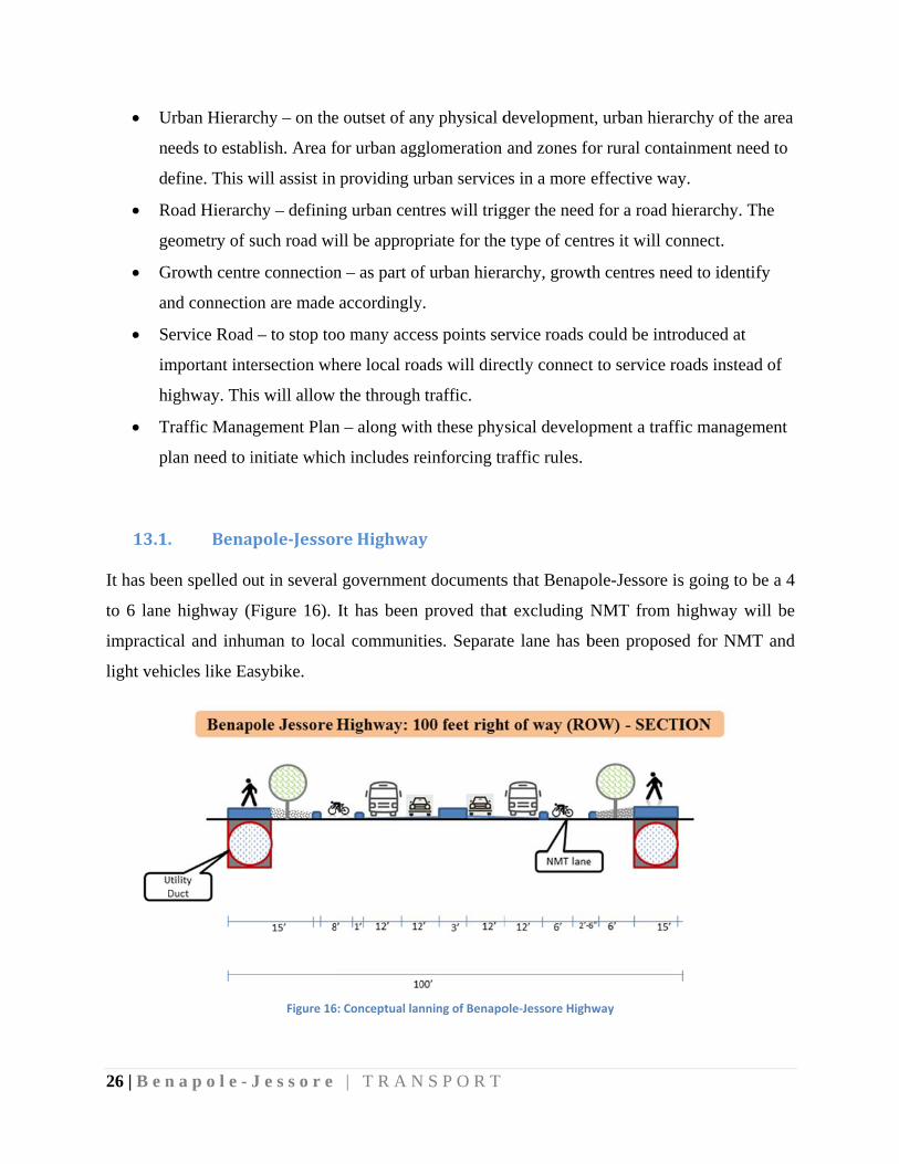
It has bee
to 6 lane
impractic
light veh
n a p o l e - J
Urban Hierar
eeds to estab
efine. This w
Road Hierarc
eometry of s
Growth centr
nd connectio
ervice Road
mportant inte
ighway. Thi
Traffic Mana
lan need to i
. Bena
en spelled ou
e highway (F
cal and inhu
icles like Ea
J e s s o r e
rchy – on the
blish. Area f
will assist in
chy – definin
such road wi
re connection
on are made
d – to stop to
ersection wh
is will allow
gement Plan
initiate whic
pole‐Jessor
ut in several
Figure 16).
uman to loca
asybike.
Figure 16
| T R A N
e outset of an
for urban agg
providing u
ng urban cen
ill be approp
n – as part of
accordingly
o many acce
here local roa
the through
n – along wit
h includes re
reHighway
l governmen
It has been
al communit
6: Conceptual lan
N S P O R T
ny physical d
glomeration
urban service
ntres will trig
priate for the
f urban hiera
y.
ess points se
ads will dire
traffic.
th these phy
einforcing tr
y
nt documents
proved that
ties. Separat
nning of Benapo
developmen
and zones fo
es in a more
gger the need
e type of cen
archy, growt
ervice roads c
ectly connect
sical develop
raffic rules.
s that Benap
t excluding
te lane has b
ole‐Jessore High
nt, urban hier
for rural cont
effective wa
d for a road h
ntres it will c
th centres ne
could be intr
t to service r
pment a traf
ole-Jessore
NMT from
been propos
hway
rarchy of the
tainment nee
ay.
hierarchy. T
onnect.
eed to identif
roduced at
roads instead
ffic managem
is going to b
highway w
sed for NMT
e area
ed to
The
fy
d of
ment
be a 4
ill be
T and
27 | B e n
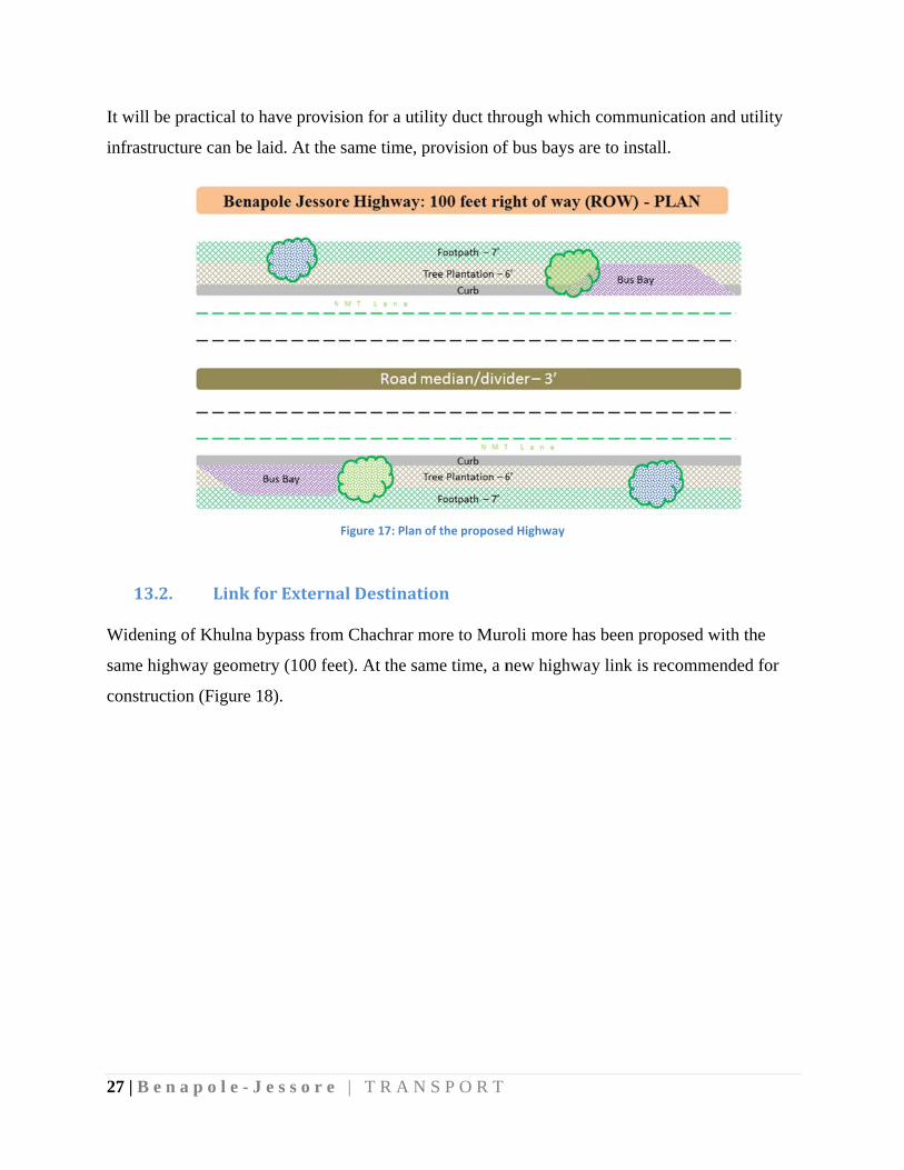
It will be
infrastruc
13.2
Widening
same hig
construct
n a p o l e - J
e practical to
cture can be
. Link
g of Khulna
ghway geome
tion (Figure
J e s s o r e
have provis
laid. At the
forExterna
bypass from
etry (100 fee
18).
| T R A N
sion for a uti
same time, p
Figure 17: Plan
alDestinat
m Chachrar m
et). At the sa
N S P O R T
ility duct thr
provision of
of the proposed
tion
more to Mur
ame time, a n
rough which
f bus bays ar
d Highway
roli more has
new highway
communica
re to install.
s been propo
y link is reco
ation and util
osed with the
ommended f
lity
e
for
28 | B e n
13.3
It is foun
hierarchy
traffic ca
that serve
given to
national h
n a p o l e - J
. Major
nd that excep
y. Several m
an avoid nati
es the local c
those roads
highway and
J e s s o r e
Figur
rRoads|L
pt the Benap
major roads
ional highwa
community
which has m
d loops are c
| T R A N
re 18: Proposed
oop|Paral
pole-Jessore
are recomm
ay (N706) a
can be move
market conn
created as de
N S P O R T
improvement o
llelRoads
e highway al
mended with
s much as th
ed and locat
nectivity. Sev
evelopment c
of external links
ll other road
h varying wi
hey can do a
ted off the hi
veral roads
can be conta
s
ds are local r
idth. Basic i
and more ec
ighway. Imp
are recomm
ained within
road withou
idea is that
onomic activ
portance has
mended paral
this loop.
ut any
local
vities
been
llel to
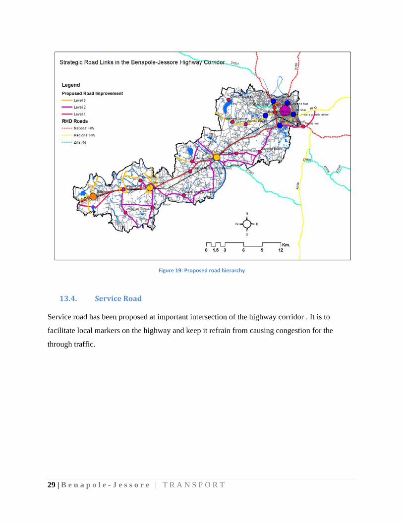
29 | B e n a p o l e - J e s s o r e | T R A N S P O R T
Figure 19: Proposed road hierarchy
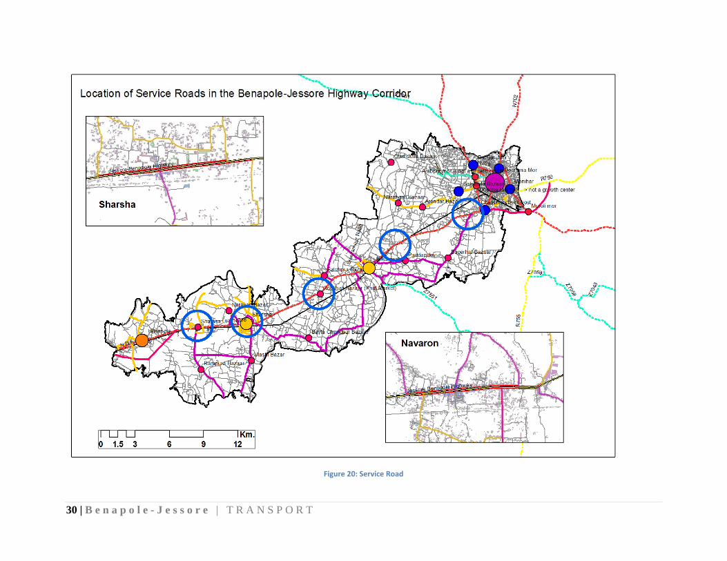
13.4. ServiceRoad
Service road has been proposed at important intersection of the highway corridor . It is to
facilitate local markers on the highway and keep it refrain from causing congestion for the
through traffic.
30 | B e n a p o l e - J e s s o r e | T R A N S P O R T
Figure 20: Service Road
31 | B e n a p o l e - J e s s o r e | T R A N S P O R T
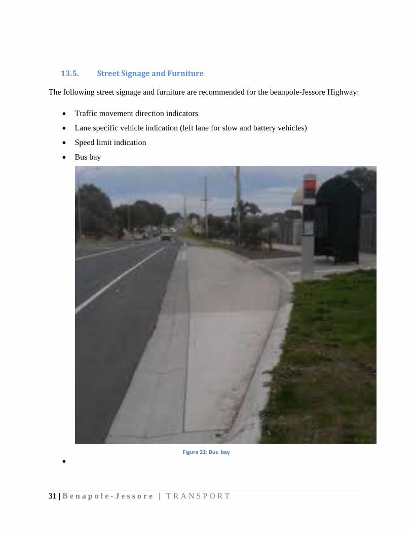
13.5. StreetSignageandFurniture
The following street signage and furniture are recommended for the beanpole-Jessore Highway:
Traffic movement direction indicators
Lane specific vehicle indication (left lane for slow and battery vehicles)
Speed limit indication
Bus bay
Figure 21: Bus bay

32 | B e n a p o l e - J e s s o r e | T R A N S P O R T
14. TransportPolicies
Benapole-Jessore corridor plays a significant role in the business and economy at local, regional
and national scale. The multi-modal transit to India has enhanced its potential by many folds. A
lion share of passenger and freight that passes through the Benapole-Jessore highway segment
does not have any direct role to the surrounding economy. However, it has spin-off imprint on
local landuse and traffic. So, the corner stones of the transport strategies are to ensure smooth
movement of traffic to and from Benapole port, facilitate the transfer, transit and foresee the
traffic scenario in the corridor area to recommend for its road hierarchy.
1. Benapole Jessore Highway: Roads and Highway Master Plan 2009 has proposed a four-
lane highway for N706 by 2020. To comply with their plan the same has been proposed
with options for light and non-motorized vehicle and pedestrian.
2. Road Hierarchy: It is prudent to establish road hierarchy that connects the economic
activities and urban centers. It has been advised to develop an urban/activity hierarchy
and then connecting road hierarchy. Activities, that attracts heavy vehicle requires to
have wider road. On the contrary, local market or bazar should be connected with both
local and major road. Because, input to the market will come through major road and the
local people by local access road.
3. Service Road: It is common in Bangladesh that highways have direct access to local
road. It is found that 35 Km of Benapole to Jessore highway has direct access to more
than hundred roads. Traffic to and from this roads to N706 cause interruption to free flow
of traffic and results in delay and congestion and hence lower performance. It is found
that location of local barket/bazar on highway is another reason. It has been proposed to
construct service roads on both side of the highway. As, activities and traffic of bazar
cannot spill over to highway and cause congestion.
4. Bus-bay: The ten major bus stops also cause congestion and delay on highway.
Construction of bus-bays are recommended on these location.
5. Railway Development: Benapole-Jessore Railway is very much under consideration for
development as part of “Corridor-3” in railway master plan 2013. Direct train between
Kolkata and Dhaka has drawn significant attention. It is expected that completion of
Padma Railway bridge and railway connectivity with Mongla port will generate heavy
33 | B e n a p o l e - J e s s o r e | T R A N S P O R T
traffic on railway along N706. The stations along this segment especially Sharsha require
to undergo a severe development to cater its increasing passenger and role being the last
rail stop in Bangladesh.
6. Regional Connectivity and Diverted Traffic: most traffic travelling through this
corridor do not destined to it or to Jessore. It goes to Kustia, Khulna, Dhaka, Chittagong
and beyond the national boundary. So, emphasis needs to put on the easy ingress and
egress with Benapole port. The current ring road is good for Kustia and Faridpur bound
traffic. But outside Southern Bangladesh, for any location it requires to croos the Jessore
town which cause congestion in the city and looks a threatening issue for the future. It
has been proposed to construct a new road from Muruli to R750. This new road will
cater all traffic to Dhaka and Chittagong and beyond. For Nawapara, Khulna and
Monglaport south part of Jessore City Bypass can be widened.
15. Conclusion
National Highway N806 is the most important link for cross border business and economic
progress for Bangladesh. The level of service (LOS) of this highway is far away below the
expected standard. This has caused by insufficient lane, mix used of vehicle, and lack of traffic
management and uncontrolled activities on road space. Along this 35 kilometer many local roads
are connected to it. These little junctions and congestion around it cause delay to traffic moving
on tis national highway. Public transport connecting Benapole-Jessore highway is vulnerable in
term of public facility. However, it is functional with attributes like delays, irregularity, poor
ticketing, crowded etc. Improvement of the facility will enhance its share by many folds. Visitors
to India are important travelers. So that needs to maintain when any improvement plan is made.
For example, travelers do carry baggage. The current buses do not have comfortable arrangement
for such. The boarding time is generally high that accumulates to a delay in stop. So,
improvement in infrastructure and management can improve this boarding time significantly.
This will improve the attractiveness of public transport hence contribute towards sustainability.
At the same time, other smaller modes like Mohindar and Auto-Rickshaw are operating on this
road. They are sometimes also operating as paratransit and serving the middle and low income
who cannot afford private vehicle. Separate management guidelines are required for their

34 | B e n a p o l e - J e s s o r e | T R A N S P O R T
operation specially to improve their safety issue. In places, management plans are required to
ensure that these public transport do not make obstacle on the major roads and flow of freight
and passenger carrying vehicles.
This highway needs to upgrade to a 4 to 6-lane which has also been addressed in the highway
master plan. And other roads connecting to it should be controlled based on urban hierarchy it
connects. With all these road expansion, hierarchy management and traffic management this
highway corridor can be a line of inspiration for economic growth. It is to note that freight
traveling through this highway is a major concern but local inhabitants who and their ancestors
lived here for decades needs to serve as well. Urban hierarchy and associated road hierarchy
need to establish as local business and villagers do get benefit from the improvement of this
corridor.
References
Hope, A. and Cox, J. 2015, Development Corridors, Coffey International Development,
South Asia Subregional Economic Coperation (SASEC), 2016, http://sasec.asia/index.php?page=news&nid=459&url=bangladesh-to-upgrade-jessore-benapole-highway
Government of The People’s Republic of Bangladesh, 2016, Regional Road Connectivity – Bangladesh Perspective, Ministry of Road Transport and Bridges, Road Transport and Highways Division, Dhaka
Government of The People’s Republic of Bangladesh, 2009, Road Master Plan, Ministry of Communications, Roads and Highways Department, Dhaka