Embed Size (px)
Citation preview

Heritage 4 – A 4D Cultural Heritage Management System
Bernhard Snizek KÖNIG/SNIZEK
Copenhagen, Denmark [email protected]
Thorbjørn König KÖNIG/SNIZEK
Copenhagen, Denmark [email protected]
Abstract— Heritage 4, an extension to Plone, a state of the art content management system was developed, combining well proven technologies to a novel way of experiencing and participating in development of historical content. Four types of search interfaces, the so called “navigators” are currently implemented into the system: mind navigation, a graphical, interactive and dynamic node-edge interface, a map-based navigator utilising the Google API, a timeline and a text search. These navigators present single content as well as collections or search results geographically, temporally and relationally. Seamless switching between navigators provides maximum flexibility during the data mining process. In addition, end users can tag and discuss objects and present and exchange their experiences with place and history.
Keywords- Cultural Heritage and Museum Environments, Innovative Applications of Technology, Social and Interactive Computing Applications
I. INTRODUCTION In 2005 the Museum of Copenhagen, Copenhagen Libraries
and the Archives of Copenhagen decided to initiate an ALM (archive / library / museum) cooperation, which should result in an Internet portal. The latter should present materials of the three institutions for a broad audience. The project was named absalon.nu [1] after Bishop Absalon, the founder of what then was called Hafnia, now Copenhagen. Already in the early stages of the project very ambitious goals were defined – the image collection and background information on acquisitions and archaeological items of the museum, the historical yearbook of the municipal historians, protocols of the town government dating back to the eighteen hundreds from the library and the complete database of the Archive should be shown on a timeline, within a graphical relational representation and on maps. In 2007 the site went online but already in late 2007 the project management agreed on the necessity of a total re-implementation as search capabilities were one-dimensional disregarding the spatio-temporal content, the graphical design a little old fashioned and the implementation of Web 2.0 capabilities very difficult. An integrated system was designed and developed on top of the very successful open source content management system (CMS) Plone [15] and absalon.nu [1] was remodeled.
II. CONSIDERATIONS In this section the considerations made prior to designing
and developing the system will be discussed, focusing mostly on user experience and system-user communication.
A. Existing sites After having conducted in-depth analyses [2] of websites
where historic content or content originating for museums was presented, a certain pattern could quickly be discovered: On the one hand there were sites produced manually in a web editor – e.g. the site of the Kunsthistorisches Museum Wien [12]. On the other hand one could find sites, which best could be described as front-ends to databases. As an example for the latter the site of the Danish Maritime Museum [5] could be named, which made their collection accessible via a standard and graphically not too appealing OPAC (Online Public Access Catalog) interface. Sometimes, search capabilities enable the user to limit the search results to a certain temporal interval. If one is lucky database contents might be shown on a map or on a graphic timeline. At the time prior to the initial design process, the development team could not find examples where maps, timelines and other representations could both give an overview over all contents as well as covey certain search results or single objects.
B. Searches – Cul-de-sac or integrated search Common for all sites analysed as well as the old absalon.nu
site was the fact that the four search tracks (text / place /time / relation) were presented more or less separated from each other. Having once searched semantically, the objects found were presented and sometimes shown on a map. From there further exploration was not possible, one had to step back to a list of search results – a further exploration via the map or within temporal constraints was not possible. The design team therefore decided to spend resources on the development and implementation of integrated, spatio-temporal search capabilities, which never should lead the user into a cul-de-sac. This special integrated search will be explained in depth further down.
C. System Design As mentioned above, there were no standard systems for
storing, handling, presentation and production of historic
content available at the time. Existing sites were usually simple adaptations of common CMSes, Wikies or simply utilized just non-dynamic technology. This means that in a typical online exhibition or collection project, a large proportion of allocated resources go into technical development. By using Heritage 4, these resources could be used for developing complex features or put into the production of content.
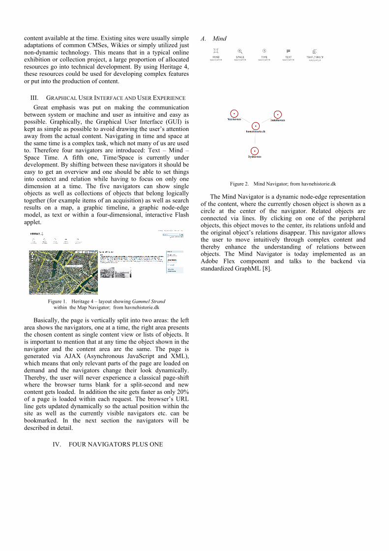
III. GRAPHICAL USER INTERFACE AND USER EXPERIENCE Great emphasis was put on making the communication
between system or machine and user as intuitive and easy as possible. Graphically, the Graphical User Interface (GUI) is kept as simple as possible to avoid drawing the user’s attention away from the actual content. Navigating in time and space at the same time is a complex task, which not many of us are used to. Therefore four navigators are introduced: Text – Mind – Space Time. A fifth one, Time/Space is currently under development. By shifting between these navigators it should be easy to get an overview and one should be able to set things into context and relation while having to focus on only one dimension at a time. The five navigators can show single objects as well as collections of objects that belong logically together (for example items of an acquisition) as well as search results on a map, a graphic timeline, a graphic node-edge model, as text or within a four-dimensional, interactive Flash applet.
Figure 1. Heritage 4 – layout showing Gammel Strand
within the Map Navigator; from havnehistorie.dk
Basically, the page is vertically split into two areas: the left area shows the navigators, one at a time, the right area presents the chosen content as single content view or lists of objects. It is important to mention that at any time the object shown in the navigator and the content area are the same. The page is generated via AJAX (Asynchronous JavaScript and XML), which means that only relevant parts of the page are loaded on demand and the navigators change their look dynamically. Thereby, the user will never experience a classical page-shift where the browser turns blank for a split-second and new content gets loaded. In addition the site gets faster as only 20% of a page is loaded within each request. The browser’s URL line gets updated dynamically so the actual position within the site as well as the currently visible navigators etc. can be bookmarked. In the next section the navigators will be described in detail.
IV. FOUR NAVIGATORS PLUS ONE
A. Mind
Figure 2. Mind Navigator; from havnehistorie.dk
The Mind Navigator is a dynamic node-edge representation of the content, where the currently chosen object is shown as a circle at the center of the navigator. Related objects are connected via lines. By clicking on one of the peripheral objects, this object moves to the center, its relations unfold and the original object’s relations disappear. This navigator allows the user to move intuitively through complex content and thereby enhance the understanding of relations between objects. The Mind Navigator is today implemented as an Adobe Flex component and talks to the backend via standardized GraphML [8].

B. Time
Figure 3. The temporal attributes of the Knippelsbro Bridge, Copenhagen:
opening for traffic, agreement on renovation and harbour board meeting (from top to bottom); from havnehistorie.dk
The Time Navigator represents the objects’ temporal features on an interactive, graphical timeline, where time is distributed horizontally. Points of time are rendered as point symbols while periods are shown as lines. A distinction is made between precise and imprecise temporal attributes. Thereby the system’s internal time format (any point in time is stored as a date plus an offset, any period as two of these points) is reflected within the user interface. Clicking on any object on the timeline reveals a pop-up, which provides with context-related temporal search options. From here the search can be continued returning any object within ± one year, ± ten years and a century with the current object’s time as a center.
C. Map
Figure 4. Toldboden, a square in Copenhagen, shown in the Map Navigator; from havnehistorie.dk
The Map Navigator shows geographic attributes and elements like points, lines and polygons and contains standard, interactive map capabilities like pan and zoom. Clicking on a geographic entity reveals a popup offering different search options depending on the entity type. From points and lines a buffer search (anything within a certain distance) can be conducted, from polygons anything overlapping or located within the polygon can be returned. Thereby the geographic context of an object or a series of objects is shown.
The Map Navigator is currently implemented in Google Maps [7] but data exchange with the backend via GML ensures that any other map view capable of interpreting this standard can be used. It’s not unthinkable that an implementation in Open Layers [14] is a possibility for sites, which can provide their own (orthographic) imagery.
D. Text
Figure 5. The Text Navigator showing content type filters and temporal
limiting; from havnehistorie.dk
The Text Navigator offers enhanced search and filter capabilities, where search results can be limited to certain content types (i.e. accession, item, article, book, event etc.) and temporal intervals. The latter makes it possible to limit search
results by year (as shown in Fig. 5) as well as selection of historic periods.
E. Time/Space
Figure 6. Time/space Navigator (sketch) showing a building’s temporal
attribute.
Currently under development, the Time/Space Navigator
will show both time and space in a three-dimensional, interactive representation. Imagine a glass cube where a map lies on the bottom and prisms of different sizes orientated along the z-axis and allocated in different heights indicate the temporal attributes of objects on location. This navigator is inspired by the work of the Time Geographers of the 60s around Hägerstrand [10][13] and provides with simple tools to distinguish between events that happened at the same time at the same place from events in different times in the same place and concurrent events in different locations.
F. Simplicity : Overview vs. Cluttering Conveying information in an optimal way by means of
maps or timelines is an art, producing interactive technologies is even more complex. Analysis of websites, for example CultureSampo [2] showed that great emphasis has to be laid on how many items to show on one map. The decision was taken to use batching, i.e. to show only ten items at a time and provide with functionality to scroll back and forth within lists of objects. This applies to all navigators.
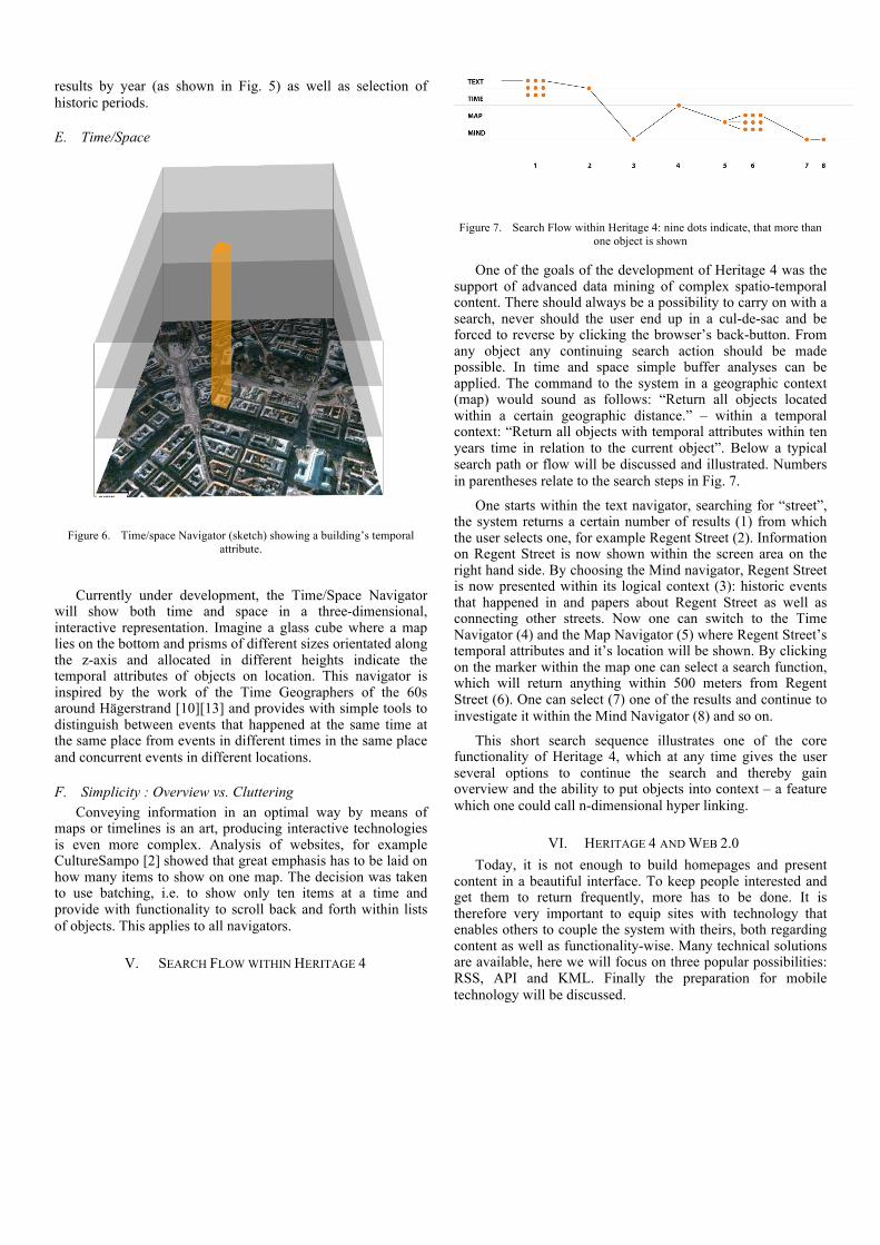
V. SEARCH FLOW WITHIN HERITAGE 4
Figure 7. Search Flow within Heritage 4: nine dots indicate, that more than
one object is shown
One of the goals of the development of Heritage 4 was the support of advanced data mining of complex spatio-temporal content. There should always be a possibility to carry on with a search, never should the user end up in a cul-de-sac and be forced to reverse by clicking the browser’s back-button. From any object any continuing search action should be made possible. In time and space simple buffer analyses can be applied. The command to the system in a geographic context (map) would sound as follows: “Return all objects located within a certain geographic distance.” – within a temporal context: “Return all objects with temporal attributes within ten years time in relation to the current object”. Below a typical search path or flow will be discussed and illustrated. Numbers in parentheses relate to the search steps in Fig. 7.
One starts within the text navigator, searching for “street”, the system returns a certain number of results (1) from which the user selects one, for example Regent Street (2). Information on Regent Street is now shown within the screen area on the right hand side. By choosing the Mind navigator, Regent Street is now presented within its logical context (3): historic events that happened in and papers about Regent Street as well as connecting other streets. Now one can switch to the Time Navigator (4) and the Map Navigator (5) where Regent Street’s temporal attributes and it’s location will be shown. By clicking on the marker within the map one can select a search function, which will return anything within 500 meters from Regent Street (6). One can select (7) one of the results and continue to investigate it within the Mind Navigator (8) and so on.
This short search sequence illustrates one of the core functionality of Heritage 4, which at any time gives the user several options to continue the search and thereby gain overview and the ability to put objects into context – a feature which one could call n-dimensional hyper linking.
VI. HERITAGE 4 AND WEB 2.0 Today, it is not enough to build homepages and present
content in a beautiful interface. To keep people interested and get them to return frequently, more has to be done. It is therefore very important to equip sites with technology that enables others to couple the system with theirs, both regarding content as well as functionality-wise. Many technical solutions are available, here we will focus on three popular possibilities: RSS, API and KML. Finally the preparation for mobile technology will be discussed.

A. RSS and geoRSS RSS (real simple syndication) is and XML-based format
that is mostly used for distribution and implementation of news on the web. Within Heritage 4, RSS is available at different levels. Search results can be obtained in RSS format which means that anyone can tailor a special search according to ones interests, grab the RSS feed and implement it into one’s own site. Any time content within one’s interest is put on the site it will also be available on the user’s site. Should the results of the search contain geographic attributes the latter will be included and thereby the RSS mutate to a geoRSS. GeoRSSes can be used directly within Google Maps [7] and enable users to build their own map mash ups and thematic maps. RSS and GeoRSSes can also be accessed on any logical level of the system. Would one navigate to foo.com/library/books one will receive a list of books within the library via the RSS. Foo.com/library/books/book-a will return a list of chapters of the book.
B. API An API (Application Programming Interface) consists of a
series of functions, methods and commands, which can be used by a programmer to access contents and functionality of a system. Primarily, an API would be used to build alternative, media rich skins (i.e. graphical designs) in different technologies such as Macromedia Flash, access raw data without layout or use a site’s functionality with data stored at a complete different place elsewhere on the net. In Heritage 4’s case, all important functions can be accessed: searches, search results, editing or storing objects as well as the generation of navigators. Heritage 4’s advanced search and data navigation features can thereby be used on any site as well as data and functionality can be implemented as so called micro sites.
C. KML
Figure 8. The places of Copenhagen’s inner harbour (Inderhavnen). Within
the bubble information on Larsens Square is given alongside with a photography of the place; from havnehistorie.dk
KML (officially OpenGIS KML Encoding Standard) is an XML-based standard for description of geographic information in two and three dimensions. The format is rather complex and can even contain 3D objects. KML was developed by Google and can be directly shown in Google Earth [6] and Google Maps. In Heritage 4 any search result and
logical levels can be returned as a KML file. By clicking the respective icon, Google Earth will open and show the content in it’s appealing interface. In addition the user can overlay data from a Heritage 4 site with other geographic data or imagery and thereby produce thematic maps.
D. Mobile technology Mobile technology is today an immensely popular medium
and carries an enormous potential for the development of interesting applications, as more and more devices have built-in GPS receivers. We ourselves are convinced that history should be taught and experienced on location rather than in a dusty museum or a noisy classroom. Therefore a mobile extension framework to Heritage 4 is currently under development, where interactive story-telling capabilities as well as information exchange and teambuilding features are included.
VII. CONCLUSION AND PERSPECTIVES Keeping the methods and technologies discussion in the
section above in mind an exciting future can be anticipated. The strict separation of the system in data, business logic (i.e. the actual functionality) and the graphical user interface as well as technologies for distribution and incorporation will make it possible to create completely new systems by combining existing databases and business logic and adding own creations. The amount of these so-called mash-ups will rise in number and move over to mobile media. At the same time desktop programs as we know them today will move to the web and open up for use of functionality. More and more laymen will be able to build their own sites reflecting their own interests and thereby add to the pool of data and functionality from which again others can take and build. The production of complex sites will thereby get easier and easier making virtually anyone a producer and presenter of historical content [3].
VIII. EPILOGUE Should the reader be interested in trying Heritage 4 one is
encouraged to visit http://www.havnehistorie.dk, which serves as an official demo for Heritage 4. http://www.absalon.nu is another site built on Heritage 4. Heritage 4, being not only a product but also to a very high degree a project is described at http://heritage4.koenigsnizek.org. Here information about current development as well as future plans can be retrieved.
IX. ACKNOWLEDGEMENTS The authors would like to express their gratitude to Rikke
Baggesen, for her contribution to the paper and for providing valuable information for the project.
REFERENCES [1] Absalon.nu, online: http://www.absalon.nu [2] Adobe, online: http://www.adobe.com/products/flex/?promoid=BPDEQ [3] Bruns, A., The Future is User-Led: The Pathtowards Widespread
Produsage, fibreculture.org; online: http://journal.fibreculture.org/issue11/issue11_bruns.html

[4] CultureSampo, online: http://www.kulttuurisampo.fi [5] The Danish Maritime Museum, online: http://www.maritime-
museum.dk [6] Google Earth, online: http://earth.google.com [7] Google Maps, online: http://maps.google.com [8] GraphML, online: http://graphml.graphdrawing.or [9] Havnehistorie, online: http://www.havnehistorie.dk [10] Hägerstrand, T. (1975): Space, time and human conditions, in: Karlqvist,
A., Lunqvist, L and Snickars, F. (eds) Dynamic Allocation of Urban Space, Farnborough: Saxon House, pp 3-14
[11] Heritage 4, online: http://heritage4.koenigsnizek.org
[12] Kunsthistoriskes Museum Wien, online: http://khm.at [13] Pred, A. (1977), The choreography of existence: comments on
Hägerstrand’s time geography and its usefulness. Economic Geography, 53, 207-221
[14] Open Layers, online: http://openlayers.org [15] Plone, online: http://plone.org [16] Snizek B. and T. König (2009): Heritage 4 – A 4D System for digital
Management of Cultural Heritage (Heritage 4 – Et 4D system, til digital håndtering af kulturarv); in Geoforum Perspektiv, Tidsskrift for Geografisk Information, March 2009, pp. 32-38


![新建 Microsoft Word 文档jiaowu.dlpu.edu.cn/Edit4/uploadfile/20140923095009323.pdf · [2009] 61 2009 2009 c 2009) 65 & ) 2009 2009 39 Y), 2009 160 n, 100 60M](https://img.pdfslide.tips/doc/110x75/5f57628b37d0bc70511eab4d/-microsoft-word-2009-61-2009-2009-c-2009-65-2009-2009-39.jpg)