Embed Size (px)
Citation preview
������������������ ���������������������������������������
����
��
���� ������
������� ������
��������� ������
�������� ������
�
��
�
� �� �� ����
��
��
����
������
��
��
��
��
����
��
������
��
��
��
��
��
��
��
������
��
��
��
��
��
����
������
��
��
��
��
��
��
����
�� ��
��
��
��
��
����
��
����
����
��
��
��
������������������
������������
����������������
���������� �� ������
��
��
��
�� ������
��
� ����!������"���#
�
���$�����
�%������� ���#
�
&������%�����''�
���� ���#
�
�� ������#�����
�
�����"���#
�%���(���
�
����"���# �
��� ����"���#
�
)�������������
�
!����"����"���#
�
������ ���#
�
*����� ��"���#
�
����+����������
�
,����������
�
����������-� ���#
�
��� ����"���#
�
�������+�������
�
�� ��-� ��"���#
�
"����������
�
*��-���"���#
�
"�� ����"���#
�
���������#��"���#
�
"�����+���� ���#
�
��-��"���#
�
,�������������
�
�-�������
�
%�������"���#
�
����"���#
��
����������
���
��
������������
�
�������-���"���#
�
(� ���"���#
�
"�� ��������
������������������ �������������� ������
./'
352
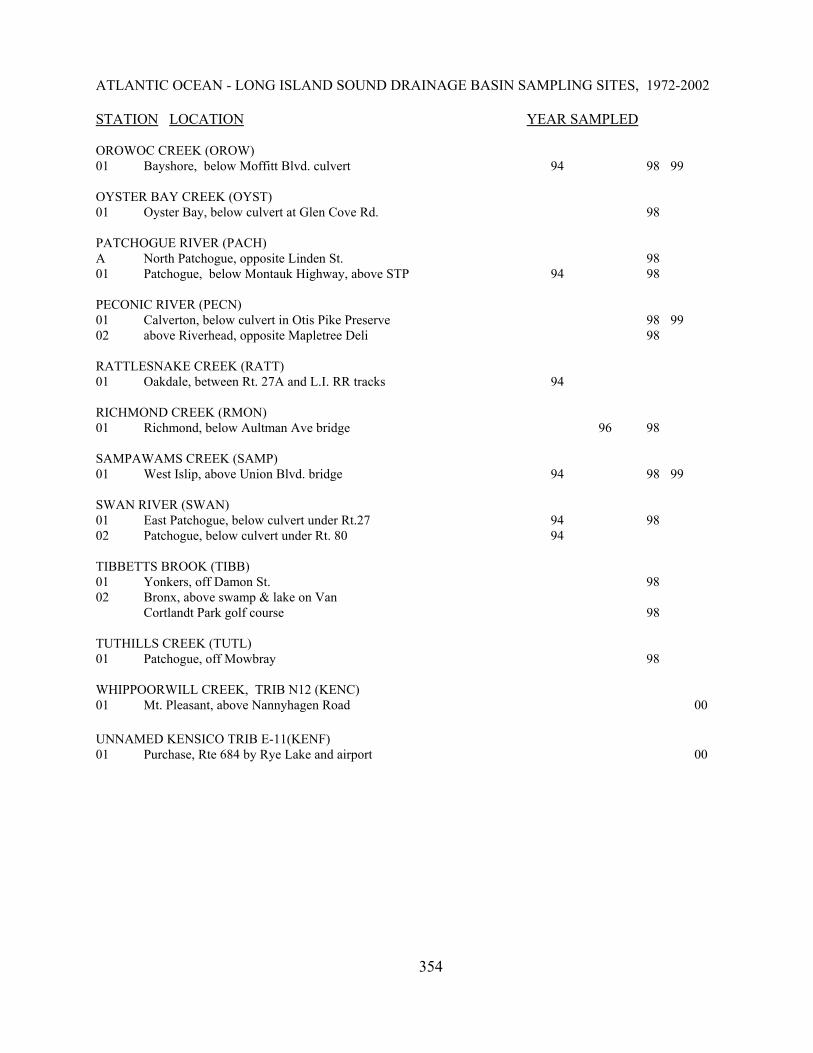
ATLANTIC OCEAN - LONG ISLAND SOUND DRAINAGE BASIN SAMPLING SITES, 1972-2002
STATION LOCATION YEAR SAMPLED
BEAR GUTTER (KEND)00 Armonk, Kaysal Ct 0101 Armonk, below Rte 22 00 01
BEAVER BROOK (BVBR)01 Mill Neck, Frost Mill Rd. 98
BELLMORE CREEK (BMOR)01 Bellmore, Wantagh State Parkway 98
BLIND BROOK (BLND)01 Purchase, Anderson Hill Road 9902 Port Chester, Lincoln Rd 9903 Port Chester, Westchester Ave 9904 Rye, at Theodore Fremd St. 98 99
BODINE CREEK (BODN)01 Port Richmond, Forest Ave. bridge; Clove Lakes Park 96 9802 Port Richmond, culvert under Richmond Terrace 96
BRONX RIVER (BRNX)01 Valhalla, Legion Rd. culvert 98 0202 White Plains, Bronx River Parkway bridge 98 0203 Tuckahoe, bridge above Crestview Station 98 0204 Bronx, above East Gun Hill Rd. bridge 98 02
BROWN CREEK (BRWN)01 Sayville, below Aldrich St. culvert 98
BYRAM RIVER (BYRM)01 Pemberwick, CT, below Comly Ave. bridge 98
CARLLS RIVER (CARL)01 Babylon, at Rt. 27 94 9802 Babylon, below Park Ave. culvert 94 98
CARMANS RIVER (CARM)01 Above Yaphank, East Bartlett Rd 89 02 Siegfield Park, below Upper Lake 8903 Below Yaphank, USGS Gaging Station 89 94 98 9904 South Haven, DEC fishing access 8905 Below South Haven, USFW Wertheim
Ranger Station 8906 Below South Haven, above Yaphank Ck 8907 Below Squassux Landing marina, Buoy 3 8908 Bellport Bay, opposite museum (Shirley) 8909 Bellport Bay, Buoy 2, opp Beaverdam Ck 8910 Bellport Bay, Buoy 8, opp Smith Point 89
353
ATLANTIC OCEAN - LONG ISLAND SOUND DRAINAGE BASIN SAMPLING SITES, 1972-2002
STATION LOCATION YEAR SAMPLED
CHAMPLIN CREEK (CHAM)01 East Islip, below Moffitt Blvd. bridge 94 98
CONNETQUOT BROOK (CONQ)01 Oakdale, above hatchery at foot bridge in park 9802 Oakdale, below hatchery in Connetquot State Park 98
EAST MEADOW BROOK, (EMED)01 Roosevelt, below Washington Ave. bridge 98
GLEN COVE CREEK (GLEN)01 Glen Cove, below USGS gage in Pratt Park 98 99
HUTCHINSON RIVER (HUCH)01 Maplewood, 100yds past inters of Wilmot & Old Wilmot 9902 Vernon, Hutchinson Blvd-west of Pkwy 9903 Vernon Park, Cnr Farell & Beechwood, under pedestrian bridge 9904 Mount Vernon, above East Sandford Ave. bridge 98 99
LEMON CREEK (LEMN)01 Pleasant Plains - Staten Island
above Amboy Rd. & Maguire Ave. bridge 96 98
THE LOCH (LOCH)01 Manhattan, Central Park, between Harlem Meer and The Pool 98
MAMARONECK RIVER (MAMR)01 White Plains, below Corporate Park Dr. bridge 9902 White Plains, off Hutchinson River Pky @ exit 23 9902A White Plains, off Saxon Woods Rd. 9904 Mamaroneck, above Ward Ave. bridge 94 98 99
MASSAPEQUA (MASS)01 Massapequa, above Clark Ave. 94 98 99
MIANUS RIVER (MIAN)03 North Castle, Greenwich Banksville Road 9104 Bedford, Middle Patent Road bridge 9105 Bedford, Miller's Mill Road bridge 9108 Riverbank (Conn.), June Road bridge 91
MILL CREEK (MILS)01 Richmond, end of service road parallel to & south of Rt. 440 96 98
MUD CREEK (MUDL)01 East Patchogue, below RR off Montauk Highway 98
NISSEQUOGUE RIVER (NISS)01 Smithtown, Rt. 25, Caleb State Park 94 98 99
354
ATLANTIC OCEAN - LONG ISLAND SOUND DRAINAGE BASIN SAMPLING SITES, 1972-2002
STATION LOCATION YEAR SAMPLED
OROWOC CREEK (OROW)01 Bayshore, below Moffitt Blvd. culvert 94 98 99
OYSTER BAY CREEK (OYST)01 Oyster Bay, below culvert at Glen Cove Rd. 98
PATCHOGUE RIVER (PACH)A North Patchogue, opposite Linden St. 9801 Patchogue, below Montauk Highway, above STP 94 98
PECONIC RIVER (PECN)01 Calverton, below culvert in Otis Pike Preserve 98 9902 above Riverhead, opposite Mapletree Deli 98
RATTLESNAKE CREEK (RATT)01 Oakdale, between Rt. 27A and L.I. RR tracks 94
RICHMOND CREEK (RMON)01 Richmond, below Aultman Ave bridge 96 98
SAMPAWAMS CREEK (SAMP)01 West Islip, above Union Blvd. bridge 94 98 99
SWAN RIVER (SWAN)01 East Patchogue, below culvert under Rt.27 94 9802 Patchogue, below culvert under Rt. 80 94
TIBBETTS BROOK (TIBB)01 Yonkers, off Damon St. 9802 Bronx, above swamp & lake on Van
Cortlandt Park golf course 98
TUTHILLS CREEK (TUTL)01 Patchogue, off Mowbray 98
WHIPPOORWILL CREEK, TRIB N12 (KENC)01 Mt. Pleasant, above Nannyhagen Road 00
UNNAMED KENSICO TRIB E-11(KENF)01 Purchase, Rte 684 by Rye Lake and airport 00
355
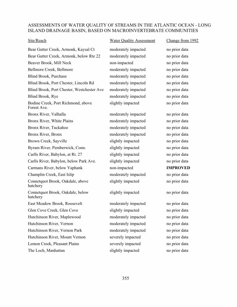
ASSESSMENTS OF WATER QUALITY OF STREAMS IN THE ATLANTIC OCEAN - LONGISLAND DRAINAGE BASIN, BASED ON MACROINVERTEBRATE COMMUNITIES
Site/Reach Water Quality Assessment Change from 1992
Bear Gutter Creek, Armonk, Kaysal Ct moderately impacted no prior dataBear Gutter Creek, Armonk, below Rte 22 moderately impacted no prior dataBeaver Brook, Mill Neck non-impacted no prior dataBellmore Creek, Bellmore moderately impacted no prior dataBlind Brook, Purchase moderately impacted no prior dataBlind Brook, Port Chester, Lincoln Rd moderately impacted no prior dataBlind Brook, Port Chester, Westchester Ave moderately impacted no prior dataBlind Brook, Rye moderately impacted no prior dataBodine Creek, Port Richmond, aboveForest Ave.
slightly impacted no prior data
Bronx River, Valhalla moderately impacted no prior dataBronx River, White Plains moderately impacted no prior dataBronx River, Tuckahoe moderately impacted no prior dataBronx River, Bronx moderately impacted no prior dataBrown Creek, Sayville slightly impacted no prior dataByram River, Pemberwick, Conn. slightly impacted no prior dataCarlls River, Babylon, at Rt. 27 slightly impacted no prior dataCarlls River, Babylon, below Park Ave. slightly impacted no prior dataCarmans River, below Yaphank non-impacted IMPROVEDChamplin Creek, East Islip moderately impacted no prior dataConnetquot Brook, Oakdale, abovehatchery
slightly impacted no prior data
Connetquot Brook, Oakdale, belowhatchery
slightly impacted no prior data
East Meadow Brook, Roosevelt moderately impacted no prior dataGlen Cove Creek, Glen Cove slightly impacted no prior dataHutchinson River, Maplewood moderately impacted no prior dataHutchinson River, Vernon moderately impacted no prior dataHutchinson River, Vernon Park moderately impacted no prior dataHutchinson River, Mount Vernon severely impacted no prior dataLemon Creek, Pleasant Plains severely impacted no prior dataThe Loch, Manhattan slightly impacted no prior data
356
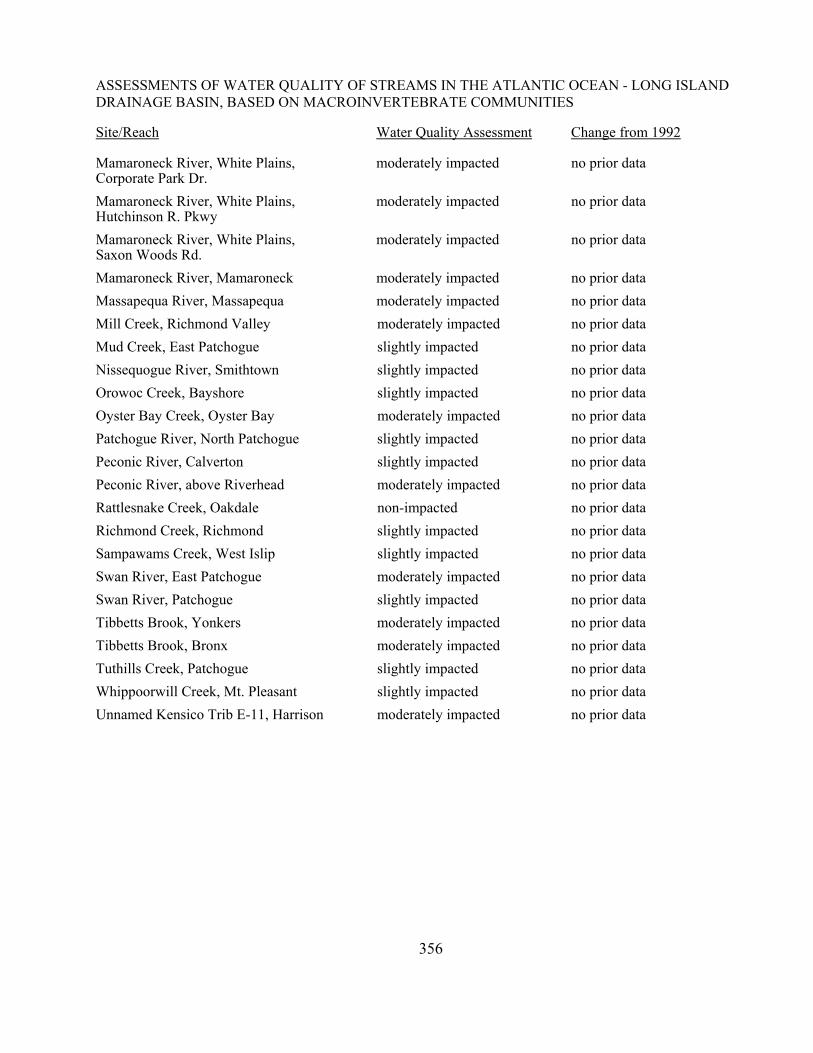
ASSESSMENTS OF WATER QUALITY OF STREAMS IN THE ATLANTIC OCEAN - LONG ISLANDDRAINAGE BASIN, BASED ON MACROINVERTEBRATE COMMUNITIES
Site/Reach Water Quality Assessment Change from 1992
Mamaroneck River, White Plains,Corporate Park Dr.
moderately impacted no prior data
Mamaroneck River, White Plains,Hutchinson R. Pkwy
moderately impacted no prior data
Mamaroneck River, White Plains,Saxon Woods Rd.
moderately impacted no prior data
Mamaroneck River, Mamaroneck moderately impacted no prior dataMassapequa River, Massapequa moderately impacted no prior dataMill Creek, Richmond Valley moderately impacted no prior dataMud Creek, East Patchogue slightly impacted no prior dataNissequogue River, Smithtown slightly impacted no prior dataOrowoc Creek, Bayshore slightly impacted no prior dataOyster Bay Creek, Oyster Bay moderately impacted no prior dataPatchogue River, North Patchogue slightly impacted no prior dataPeconic River, Calverton slightly impacted no prior dataPeconic River, above Riverhead moderately impacted no prior dataRattlesnake Creek, Oakdale non-impacted no prior dataRichmond Creek, Richmond slightly impacted no prior dataSampawams Creek, West Islip slightly impacted no prior dataSwan River, East Patchogue moderately impacted no prior dataSwan River, Patchogue slightly impacted no prior dataTibbetts Brook, Yonkers moderately impacted no prior dataTibbetts Brook, Bronx moderately impacted no prior dataTuthills Creek, Patchogue slightly impacted no prior dataWhippoorwill Creek, Mt. Pleasant slightly impacted no prior data Unnamed Kensico Trib E-11, Harrison moderately impacted no prior data
357
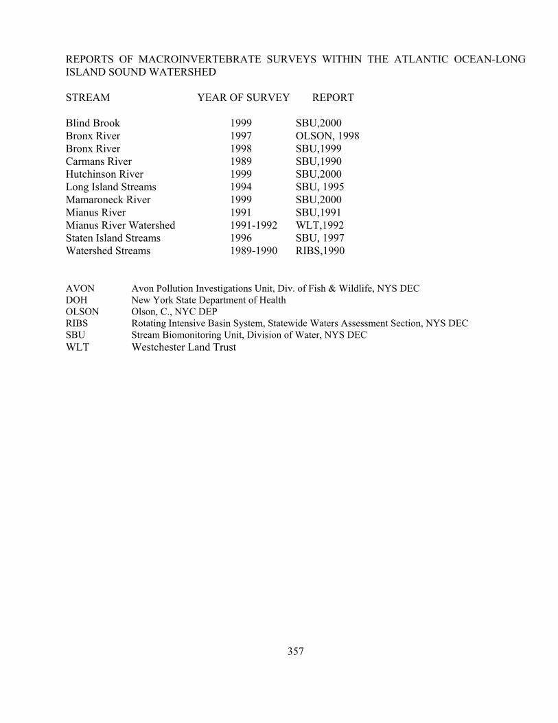
REPORTS OF MACROINVERTEBRATE SURVEYS WITHIN THE ATLANTIC OCEAN-LONGISLAND SOUND WATERSHED
STREAM YEAR OF SURVEY REPORT
Blind Brook 1999 SBU,2000Bronx River 1997 OLSON, 1998Bronx River 1998 SBU,1999Carmans River 1989 SBU,1990Hutchinson River 1999 SBU,2000Long Island Streams 1994 SBU, 1995Mamaroneck River 1999 SBU,2000Mianus River 1991 SBU,1991Mianus River Watershed 1991-1992 WLT,1992Staten Island Streams 1996 SBU, 1997Watershed Streams 1989-1990 RIBS,1990
AVON Avon Pollution Investigations Unit, Div. of Fish & Wildlife, NYS DECDOH New York State Department of HealthOLSON Olson, C., NYC DEPRIBS Rotating Intensive Basin System, Statewide Waters Assessment Section, NYS DECSBU Stream Biomonitoring Unit, Division of Water, NYS DECWLT Westchester Land Trust
358
Bear Gutter CreekModerately impacted water quality is assessed for Bear Gutter Creek. Two sites were
sampled in Armonk in 2001, and exhibited macroinvertebrate faunas composed primarily of tolerantmidges, worms, and crustaceans, although mayflies were also present. Poor habitat was a factor atboth sites, and sandy stream criteria were used to evaluate the data. Municipal/industrial inputs andurban runoff are the likely stressors. Elevated levels of 3 PAHs were found in tissues of crayfishcollected at the downstream site in 2000.
Beaver BrookWater quality in Beaver Brook is assessed as non-impacted, based on invertebrate sampling
at Mill Neck in 1998. The stream bottom was composed entirely of sand and silt, with tree roots andmacrophytes providing habitat for invertebrates. Sandy stream criteria were used to evaluate thedata. Several brown trout were seen at this site.
Bellmore CreekWater quality at Bellmore in 1998 showed moderate impact, mostly by municipal/industrial
sources. The dominance of worms and sowbugs pointed to organic inputs. Filamentous algae wasalso heavy at this site. Sandy stream criteria were used to evaluate the data.
Blind BrookBased on macroinvertebrate kick sampling from Purchase to Rye in 1999, water quality was
assessed as moderately impacted for this entire reach.. Nonpoint runoff is the probable cause ofimpact; airport and golf course runoff may be major contributors. The entire length of Blind Brookshould be listed as a priority waterbody. Habitat in this stream is mostly favorable, but water qualityis poor. Crayfish collected from the site in Port Chester exhibited very high levels of PAHs, andthis is likely a major factor limiting water quality. A follow-up collection of crayfish at the upstreamsite at Purchase by Holly Bukofser in 2001 did not show any PAHs exceeding levels of concern.This indicates that PAHs likely enter the stream between Purchase and Port Chester.
Bodine Creek Water quality is assessed as slightly impacted in Bodine Creek, based on kick sampling at
Port Richmond, Staten Island, in 1998. This site was previously sampled in 1996, and was assessedas moderately impacted. Further sampling is needed to determine if this is an improvement trend.Dissolved oxygen measured in the 1998 sampling was 4.8 (62% saturation). Habitat at this site wasvery good, and capable of supporting a more diverse fauna. A sample taken at Richmond Terracein Port Richmond in 1996 was considered invalid since high conductivity indicated tidal conditions.This location is dropped as a sampling site.
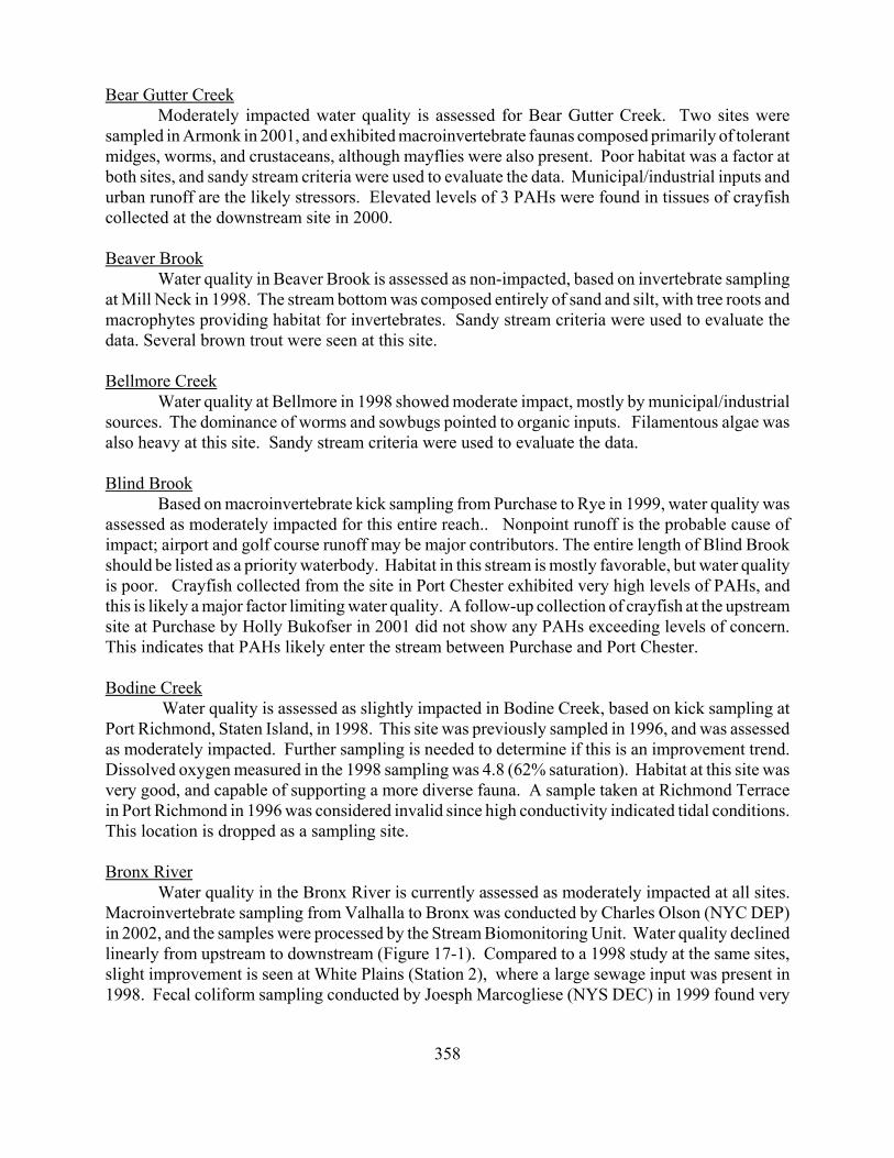
Bronx RiverWater quality in the Bronx River is currently assessed as moderately impacted at all sites.
Macroinvertebrate sampling from Valhalla to Bronx was conducted by Charles Olson (NYC DEP)in 2002, and the samples were processed by the Stream Biomonitoring Unit. Water quality declinedlinearly from upstream to downstream (Figure 17-1). Compared to a 1998 study at the same sites,slight improvement is seen at White Plains (Station 2), where a large sewage input was present in1998. Fecal coliform sampling conducted by Joesph Marcogliese (NYS DEC) in 1999 found very
359
0510152025
Wat
er Q
ualit
y Sc
ale
1997 - Olson data 1998 - DEC data1998 - DEC Fish data 2002 - Olson/DEC data
Wat
er Q
ualit
y Im
pact
slig
htm
oder
ate
seve
re n
on-
Miles from the 1 2 3 4 Stat ion
10
7.5
5
2.5
0
Figure 17-1. Water quality in the Bronx River, Valhalla to Bronx, as assessed bydifferent studies.
high levels in White Plains that pointed to a sewage discharge into the city storm drain system. Theinput is nowreported to beremediated, andmayflies werefound at this sitein 2002. Anotherinput of rawsewage betweenStations 3 and 4was corrected in1999. Impacts inthe river arecurrently causedby remain ingmunicipal andi n d u s t r i a ldischarges andrunoff, includingm a n y i l l e g a ls a n i t a r yconnections tostorm sewers int h e c i t y o fYonkers. Fishsampling by Doug Carlson (NYS DEC Fish & Wildlife) in 1998 showed trends similar to invertebrate data, with assessments ranging from slightly impacted to moderately impacted. Formany years the stream was stocked annually with brown trout, but this was recently discontinued.A contaminant trackdown study by Joseph Spodaryk (NYS DEC Fish & Wildlife) projected thatmany fish in the Bronx River would have total chlordane levels exceeding the FDA limit.
Brown CreekBased on 1998 sampling at Sayville, water quality is assessed as slightly impacted. The sand
and gravel stream bottom likely contributed to the limited invertebrate fauna, as well as nonpointsource nutrient enrichment. No major water quality problems appear to be indicated. Sandy streamcriteria were used to evaluate the data from this site.
Byram RiverWater quality is assessed as slightly impacted, based on 1998 sampling at Pemberwick,
Connecticut. The fauna was dominated by snails and caddisflies, and filamentous algae was veryabundant on the stream bottom. ISD denoted nonpoint source nutrient enrichment and possible toxicstressors.
360
0
2.5
5
7.5
10
1989 1994 1998 1999
Wat
er Q
ualit
y Sc
ale
EPT NCO HBI SPP A VG
Wat
er Q
ualit
y Im
pact
slig
htm
oder
ate
seve
re n
on-
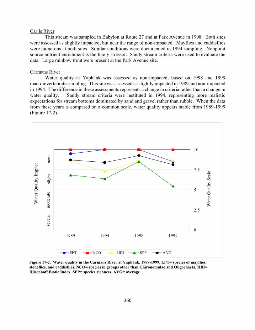
Figure 17-2. Water quality in the Carmans River at Yaphank, 1989-1999. EPT= species of mayflies,stoneflies, and caddisflies, NCO= species in groups other than Chironomidae and Oligochaeta, HBI=Hilsenhoff Biotic Index, SPP= species richness, AVG= average.
Carlls RiverThis stream was sampled in Babylon at Route 27 and at Park Avenue in 1998. Both sites
were assessed as slightly impacted, but near the range of non-impacted. Mayflies and caddisflieswere numerous at both sites. Similar conditions were documented in 1994 sampling. Nonpointsource nutrient enrichment is the likely stressor. Sandy stream criteria were used to evaluate thedata. Large rainbow trout were present at the Park Avenue site.
Carmans RiverWater quality at Yaphank was assessed as non-impacted, based on 1998 and 1999
macroinvertebrate sampling. This site was assessed as slightly impacted in 1989 and non-impactedin 1994. The difference in these assessments represents a change in criteria rather than a change inwater quality. Sandy stream criteria were instituted in 1994, representing more realisticexpectations for stream bottoms dominated by sand and gravel rather than rubble. When the datafrom these years is compared on a common scale, water quality appears stable from 1989-1999(Figure 17-2).
361
Champlin CreekBased on 1998 invertebrate sampling at Islip Terrace, water quality was assessed as
moderately impacted. The stream bottom was mostly sand and gravel, and the fauna was dominatedby midges and scuds. Similar conditions were found in 1994 at an East Islip site on ChamplinCreek. It is likely that poor habitat and poor water quality both contribute to the limited fauna. ISDdenoted organic wastes as the primary stressor. Sandy stream criteria were used to evaluate the datafrom this site.
Connetquot BrookThis stream was sampled at two sites in Connetquot State Park, Oakdale in 1998. Both sites
were assessed as slightly impacted. Both sites contained mayflies and caddisflies, and the upstreamsite also contained stoneflies. Sowbugs were numerous at both sites, and impoundment effects arelikely influencing the fauna. No major water quality problems are indicated.
East Meadow BrookWater quality was assessed as moderately impacted, based on 1998 invertebrate sampling
at Roosevelt. Poor substrate that consisted of concrete pieces over gravel likely contributed to thelimited fauna. This situation made it difficult to determine the extent of any water qualityproblems.
Glen Cove CreekBased on invertebrate sampling in 1998 and 1999 at Glen Cove, water quality was assessed
as slightly impacted. The fauna was mostly dominated by worms. Caddisflies were present, butmayflies were not found. The source of impact is likely from nonpoint sources; many golf coursesin the watershed may contribute nutrient and pesticide loadings.
Hutchinson RiverBased on sampling at one site in 1998 and four sites in 1999, water quality was assessed as
moderately impacted to severely impacted. Most of the impact appears assignable to sewage inputs.The invertebrate fauna at the East Sanford Boulevard site in Mount Vernon indicates extremesewage pollution. There is likely a major sewage input in the half-mile reach above East SanfordBoulevard. The three stations upstream of Mount Vernon showed moderate impact, from unknownsources. Impact Source Determination showed that macroinvertebrate communities in the river aremostly affected by sewage and municipal/industrial inputs.
Lemon CreekWater quality at Pleasant Plains was assessed as severely impacted, based on 1998
invertebrate sampling. The fauna consisted entirely of tolerant midges, worms, and snails. This wassimilar to a 1996 sampling of this site, and was attributable to discharges of failing septic systems,a long-standing problem. Daytime dissolved oxygen at this site was only 3.7 ppm (42% saturation). Programs are underway installing sanitary sewers and handling storm flows, and should improvethe quality of this waterbody in the future.
The LochThis stream, connecting Harlem Meer and “The Pool” in Central Park, Manhattan, was
362
sampled for macroinvertebrates in 1998. Based on the indices, water quality was assessed as slightlyimpacted. The fauna, dominated by midges and caddisflies, was likely controlled primarily byimpoundment effects from the upstream pond. Although the sampling produced little water qualityinformation, it was collected to establish baseline data for the waterbody.
Mamaroneck RiverBased on sampling at one site in 1998 and four sites from White Plains to Mamaroneck in
1999, water quality was assessed as moderately impacted for the entire reach. Runoff from areasof high population density and high percentage of impervious surfaces are likely causes of impactin the river. Based on results of the present survey, the entire length of the Mamaroneck Rivershould be listed as a priority waterbody. Since the invertebrate fauna appears moderately impactedby poor water quality, fish propagation may be affected for some species.
Massapequa CreekWater quality at Massapequa is currently assessed as moderately impacted, based on
macroinvertebrate sampling in 1999. Caddisflies were abundant at this site, and mayflies werepresent but limited; tolerant sowbugs were numerous. This site was assessed as slightly impactedin 1994 and 1998. Impacts at this site may be caused in large part by flow-dependent urban runoff.
Mill CreekBased on 1998 sampling at Richmond Valley, water quality was assessed as moderately
impacted. The fauna was dominated by scuds, midges, and worms, and municipal/industrial inputsare indicated. This site was assessed as slightly impacted in 1996. It is not known if a change inwater quality has occurred, since poor habitat exerts a strong influence on the limited fauna.Programs are underway installing sanitary sewers and handling storm flows, and should improvethe quality of this waterbody in the future.
Mud CreekThis stream was sampled near the Montauk Highway at East Patchogue in 1998, and was
assessed as slightly impacted. Sowbugs and scuds dominated the sample, but clean-water stoneflieswere also found. Young brook trout were previously collected here (Bruce Cronemeyer, DEC. pers.comm.). No major water quality problems are indicated.
Nissequogue RiverCurrent water quality of the Nissequogue River is considered to be slightly impacted, but
close to the range of non-impacted. The fauna in all samplings has included many clean-waterspecies, but species richness is low. Nonpoint sources are indicated. Water quality at Smithtownwas assessed as slightly impacted in 1994 and 1999, and non-impacted in 1998. The speciesrichness metric excluded from the 1999 data as being a non-representative outlier; sandy streamcriteria were used to evaluate the data. The freshwater Asian clam Corbicula fluminea is found atthis site.
Orowoc CreekWater quality is currently assessed as slightly impacted, based on 1999 sampling at Brook
Street in Bayshore. Sampling at this site in 1998 denoted moderate impact. The fauna in 1999 was
363
dominated by filter-feeding caddisflies, while the 1998 fauna was dominated by sewage-tolerantsowbugs. Organic wastes are indicated to be the primary stressor. The stream was sampled in 1994at Moffitt Boulevard, and was determined to be moderately impacted.
Oyster Bay CreekModerately impacted water quality was assessed for a site at Oyster Bay, based on
invertebrate sampling in 1998. The fauna was heavily dominated by worms. The stream bottomwas composed primarily of sand and gravel, and this likely contributed to the limited fauna. Sandystream criteria were used to evaluate the data. ISD denoted municipal/industrial inputs were theprimary stressors. Trout were present at this site, and may be a better indicator of water quality. Patchogue Creek
Based on 1998 sampling at North Patchogue, water quality was assessed as slightlyimpacted. Scuds and black flies dominated the sample, but some mayflies and stoneflies were alsopresent. Municipal/industrial inputs are the likely stressors. The Patchogue Creek site sampled in1994 in Patchogue below the Montauk Highway was likely tidal. Those results do not accuratelyrepresent water quality, and the site is dropped.
Peconic RiverWater quality is currently assessed as slightly impacted for the Peconic River, based on
macroinvertebrate sampling in 1998 and 1999. The Calverton site was assessed as only slightlyimpacted in 1999, a low-flow year, and the fauna was dominated by clean-water mayflies. Sampling at Calverton and Riverhead in 1998 denoted moderately impacted water quality.Dissolved oxygen was very low (2.8 ppm) at the Calverton site in 1998, and the invertebrate faunawas dominated by midges and scuds. Dissolved oxygen was higher (6.0 ppm) at the Riverhead site,but the fauna was still dominated by tolerant organisms, mostly scuds, worms, and midges. Thecause of impact was not determined. Sandy stream criteria were used to evaluate the data from thissite.
Rattlesnake CreekWater quality is assessed as non-impacted for Rattlesnake Creek. A site at Oakdale was
sampled in 1994, and the fauna was dominated by clean-water mayflies, stoneflies, and caddisflies.Standing crop was low, likely reflecting the headwater nature of the stream.
Richmond CreekSlightly impacted water quality was assessed for this Staten Island stream at Richmond,
based on 1998 sampling. The fauna included viable populations of mayflies and caddisflies. ISDdenoted municipal/industrial stressors. This site was assessed as moderately impacted in 1996.Further sampling is recommended at the site. Programs are underway installing sanitary sewers andhandling storm flows, and should improve the quality of this waterbody in the future.
Sampawams CreekBased on 1998 and 1999 sampling at West Islip, water quality was assessed as slightly
impacted. Municipal/industrial inputs are indicated to be the primary stressors. This site was
364
previously assessed as moderately impacted in 1994. Caddisflies were more numerous in 1998 and1999, and may indicate improved conditions, although tolerant worms, scuds, and sowbugs continueto be abundant. Additional sampling at this site would be helpful in better defining water qualityconditions.
Swan RiverWater quality was assessed as moderately impacted, based on 1998 invertebrate sampling
downstream of Route 27, East Patchogue. Mayflies, stoneflies, and caddisflies were absent, and thefauna was dominated by scuds and worms. Municipal/industrial inputs are indicated to be theprimary stressors. This appears to represent a decline from 1994, when four species of mayflieswere found, and water quality was assessed as only slightly impacted. A site in Patchogue sampledin 1994 was also assessed as slightly impacted.
Tibbetts BrookBased on 1998 sampling at Yonkers and Bronx, overall water quality is assessed as
moderately impacted. The Yonkers site had adequate current speed, but the stream bottom waspredominately sand and gravel. The water had a slight grey tint, possibly reflecting sewage inputs.The benthic invertebrate fauna consisted mostly of tolerant midges and worms, and had greatestsimilarity to streams affected by sewage or animal wastes. The current speed at the Bronx site wasvery slow, and the habitat was more that of a wetland than a stream. Sampling consisted of usingthe net to skim through the top layer of sediment. The benthic invertebrate fauna consisted mostlyof midges, worms, fingernail clams, and sow bugs. Overall water quality was assessed asmoderately impacted, although this assessment is considered provisional because stream criteria areapplied to a wetland situation.
Tuthills CreekThe 1998 sampling of Tuthills Creek yielded an assessment of slight impact. The site was
downstream of Route 27, Patchogue, accessed off the end of Mowbray Street. Midges and blackflies dominated the sample, but a few mayflies and stoneflies were also found. A fingerling brooktrout was also collected at this site. The limited fauna was likely related to nonpoint sources and theless-than-optimal stream bottom habitat of gravel and sand. Sandy stream criteria were used toevaluate the data.
Whippoorwill CreekWater quality is assessed as slightly impacted for this tributary of the Kensico Reservoir.
A site near the mouth was sampled in 2000. Although clean-water stoneflies were found, midgesand worms dominated the sample, and mayflies were poorly represented. Nonpoint source nutrientenrichment was indicated to be the primary stressor.
Unnamed Kensico tributary “E-11"Moderate impact from complex stressors is indicated for this site, adjacent to the Westchester
County Airport.. The habitat is more of a wetland than a stream. The invertebrate fauna sampledin 2000 was dominated by scuds and midges. Due to the nature of the site, criteria for slow sandystreams were used.