Embed Size (px)
Citation preview
União das Freguesias de Castrelos e Carrazedo
Percurso pedestre registado e homologadopela: | Path Registered as Certified by:
Promotor | Promoters: Percurso inserido | Route inserted:
CONTATOS ÚTEIS | USEFUL CONTACTS
Seguir apenas pelo trilho sinalizado Keep to the signposted track
Evitar fazer ruídos desnecessários Avoid making unnecessary noise
Observar a fauna sem perturbar Observe wildlife without disturbing it
da ifi ar a ra t da age the ra
Não deixar lixo ou outros vestígios de passagem Do not leave rubbish or any other trace
Não fazer lume a ed a es
Não colher amostras de plantas ou rochas Do not take samples of plants or rocks
Ser afável com as pessoas que encontre no local Be nice to the people you might meet along the way
NORMAS DE CONDUTA | CODE OF CONDUCT
Levaada
Todo o percurso é parte integrante do Sítio Rede Natura 2000 Montesinho Nogueira. Esta área caracteriza-se por um interessante “mosaico de habitats”, no qual se evidenciam os matos rasteiros, extensos carvalhais de carvalho-negral (Quercus pyrenaica), azinhais (Quercus rotundifolia) de crescimento lento, prados permanentes (lameiros) essenciais à agricultura de montanha, muito baseada na exploração pecuária extensiva de ovinos e bovinos, e ecossistemas ribeirinhos. No que se refere à fauna esta é uma das áreas mais importantes, a nível nacional, para a conservação do lobo (Canis lupus). Já nas áreas aquáticas e ribeirinhas, estão inventariadas espécies como a toupeira-de-água (Galemys pyrenaicus), a lontra (Lutra lutra), o lagarto de água (Lacerta schreiberi) e a panjorca (Rutilis arcasii).
The whole route takes place in the Montesinho Nogueira Site, part of the Natura 2000 Network. This area is characterized by an interesting “mosaic of habitats”, in which it is possible to highlight the low vegetation, the extensive oak woods of Pyrenean oak (Quercus pyrenaica) and Evergreen oak (Quercus rotundifolia) of slow growth, the permanent grassland (meadows), which is essential for mountain farming based on extensive sheep and cattle breeding, and the riverside ecosystems. In relation to fauna, this is one of the most important areas for wolf (Canis lupus) conservation on a national level. At the riverside and aquatic areas, it is possible to fi d s e ies s h as the Pyre ea des a Galemys pyrenaicus), otter (Lutra lutra), the Iberian emerald lizard (Lacerta schreiberi) and bermejuela (Rutilis arcasii).
Carrazedo é uma pequena aldeia e sede de Freguesia, localizada na vertente setentrional da Serra da Nogueira. Aqui a principal atividade económica ainda é a agricultura e o pastoreio, daí que em torno da aldeia se observem bonitos prados, vulgarmente designados de lameiros. Em termos populacionais a freguesia apresenta uma elevadíssima taxa de despovoamento. Destaca-se entre o casario a Igreja Matriz. Localizada a Sudeste de Carrazedo, Zoio é também uma simpática aldeia transmontana, sede de Junta de freguesia. Aí merecem visita o Largo Histórico e a Igreja Matriz.
Carrazedo is a small village and parish council, located on the northern slope of Nogueira Mountain. Here the main economical activities are still agriculture and pasture, due to this it is possible to observe beautiful meadows around the village, commonly called “lameiros”. In terms of population, the parish presents a very high rate of depopulation. Among the houses, the main church stands out. Located southeast of Carrazedo, Zoio is also a nice village, from the Portuguese region of Trás-os-Montes, and headquarters for the parish council. Here, the historical square and the main church are worth the visit.
TRILHO DA FLORESTAE BIODIVERSIDADEBIODIVERSITY AND FOREST TRAIL
PR4 BGC
AS ALDEIASTHE VILLAGES
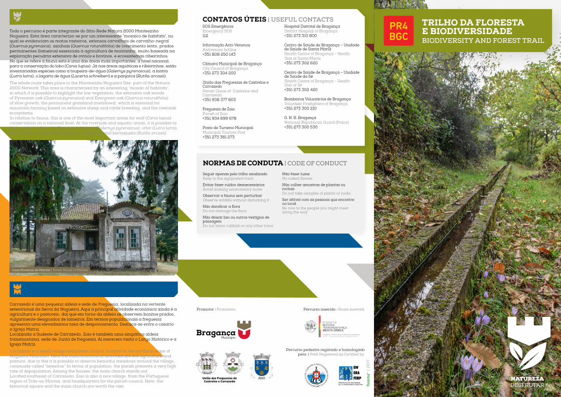
Casa Florestal de Martim | Forest House of Martim
SOS EmergênciaEmergency SOS112
Informação Anti-VenenosAntivenom hotline+351 808 250 143
Câmara Municipal de BragançaCity Council of Bragança+351 273 304 200
União das Freguesias de Castrelos e CarrazedoParish Union of Castrelos and Carrazedo+351 938 377 803
Freguesia de ZoioParish of Zoio+351 934 699 678
Posto de Turismo MunicipalMunicipal Tourism Post+351 273 381 273
Hospital Distrital de BragançaDistrict Hospital of Bragança+351 273 310 800
Centro de Saúde de Bragança – Unidade de Saúde de Santa MariaHealth Centre of Bragança – Health Unit of Santa Maria+351 273 302 620
Centro de Saúde de Bragança – Unidade de Saúde da SéHealth Centre of Bragança – Health Unit of Sé+351 273 302 420
Bombeiros Voluntários de Bragançateer irefighters raga a
+351 273 300 210
G. N. R. BragançaNational Republican Guard (Police)+351 273 300 530
PATRIMÓNIO NATURALNATURAL HERITAGE

SINALÉTICA | SIGNAGE
caminho certoright way
caminho erradowrong way
® FCMP
®® ® ®
virar à esquerdaturn left
virar à direitaturn right
PERFIL DE ALTIMETRIA | GAENT PROFILE
Traçado do percurso nas Cartas Militares de Portugal nº 037, provenientes do Instituto Geográfico do Exército.
Tracing of the route in the Portuguese Military Map l nº 037, from the Geographic Institute of the Army.
NFICHA TÉCNICA TECHNICAL SHEET
O percurso tem início em Carrazedo e segue na direção de Zoio. Os primeiros 700 metros coincidem com o percurso Carrazedo – Alimonde. Logo depois do início da Estação da Biodiversidade de Carrazedo, os percursos separam-se e este segue na direção do Sítio da Pombeira, entrando num bosque de carvalho negral. Passa-se a Casa resta da P beira e fi d b s e seg e se r a i h s agr as até à aldeia de Zoio. Depois de visitar a aldeia, toma-se a direção de Martim, e ao
hegar Casa resta regressa se a Carra ed r a i h resta
he r te begi s i Carra ed a d heads t i he first etres i ide with the route Carrazedo/ Alimonde. Soon after the entrance to the Carrazedo Biodiversity Station, the routes separate and this one heads towards the Place of Pombeira, crossing a Pyrenean oak wood. Passing the Forest House of Pombeira and the woods, agricultural paths are used to arrive at the village of Zoio. After visiting the village, the route continues to Martim. Upon reaching the Forest House, the return to Carrazedo is done through forest paths.
PONTOS DE INTERESSE | PLACES OF INTEREST
0 1km
Carrazedo;
Casa Florestal da Pombeira Forest House of Pombeira;
Zoio;
1
2
3
4
LEGENDA DO MAPAMAP LEGEND
Casa Florestal de Martim Forest House of Martim.
Capela de Zoio | Chapel of Zoio
PR4
PR3
BTT
Linhas de água | Watercourse
Curvas de nível | Contour
Estradas | Roads
Auto-estradasMotor way
Outras estradasOther roads
Estradas de terra Track
difi adBuilding
FlorestasFlorest
ÁguaWater
Ocupação de solo | Land occupation
(m)
(km)
1000
950
900
850
0 1 5 9 122 6 103 7 114 8
1
2
3
4
Todo o anoépoca aconselhada
All year roundrecommended season
GPS41° 46.323’N
6° 53.902’W
Médio (Nível III)gra de difi dade
Medium (level 3)di fi ty e e
1018/837 maltitude máx/minaltitude max/min
338 mdesnível acumuladoaltitude variation
4 hduraçãotime
12,5 kmdistânciadistance
Circularsentido contrário aodos ponteiros do relógiocounter clockwise
PERCURSO ROUTE


![lJ`,[QF6 - Shodhgangashodhganga.inflibnet.ac.in/bitstream/10603/1946/11/11_chapter4.pdf · d pÀfznftfgl ;fdfgi dflctlg]\ lj`,[qf6:+lv5]z]qf 5|df6 v\u[gf 5|:t]t ;\xmwg sfi"df\ pÀfznftfgl](https://img.pdfslide.tips/doc/110x75/5f79ada75a845b303e4a1549/ljqf6-d-pfznftfgl-fdfgi-dflctlg-ljqf6lv5zqf-5df6-vugf-5tt.jpg)


![SUZUKI aIC..o~lJ~/C..o~lJ@]](https://img.pdfslide.tips/doc/110x75/62607036089889370d1fda0d/suzuki-aicoljcolj.jpg)