Embed Size (px)
Citation preview
!n
!n
!n
!n
!n
!n
!n
!n
!n
!n
!n
!n
!n
!n
!n
!o
!o
!n
!n
!n
!Ã
S T O N IN G T O N
LED YA R D
G R O T O N
N O R T H S T O N IN G T O N
SA
SA
SB
SB
SB
A
SA
AA
SA
A
A
SA
AA
AA
SA
AA
AA
AA
B
SA
Noank
Mystic
Pawcatuck
Old Mystic
Laurel Glen
West Mystic
Lords Point
Wequetequock
Clarks Falls
Center Groton
Clarks Village
Groton Long Point
Rose Hill
Fort Hill
Ram Point
Pine Point
Clam Point
Ram Island
Cider Hill
Pequot Hill
Dark Hollow
Barn Island
Gallup Hill
Jeremy Hill
Goat Island
Hall Island
Church Hill
Lords Point
Mason Point
Willow Point
Hinkley Hill
Major Island
Perch Island
Gayitt Point
Morgan Point
Sandy Hollow
Mouse Island
Merritt Hill
Lantern Hill
Murphy Point
Spence Point
Lyddy Island
Elihu IslandMason Island
Gates Island
Twin Brothers
Enders Island
Mumford Point
Dodges Island
Hazelnut Hill
Quoketaug Hill
Wintechog Hill
Pawcatuck Rock
Andrews Island
Cossaduck Hill
Sixpenny Island
Pawcatuck Point
Wamphassuc Neck
Stonington PointWamphassuc Point
Groton Long Point
Certain Draw Point
Stanton Weir Point
Noank Dock
DuBois Beach
Esker Point Beach
SB
A
B
SA
AA
SA
A
SB
SA
B
SA
SA
B
A
A
SA
B
SB
SA
B
B
SB
A
SA
SA
Red Brook
Lee Brook
Long Pond
Hyde Pond
Edge Pond
Hall Cove
West Cove
Vagus Pond
Stony Pond
Stone Pond
Smith Lake
Small Pond
Silex Pond
Lewis Pond
Lewis Pond
Hibbs Pond
Haley Pond
Brown Pond
Beebe PondNoank Cove
Beebe Cove
Stony Brook
Copps Brook
Hewitt Pond
Gallup Pond
Palmer Cove
Wilcox Cove
Phelps Brook
Mystic River
Haleys Brook
Haleys Brook
Stanley Pond
Silvias Pond
Mumford Cove
Wyassup Brook
Wheeler Brook
Shunock River
Shunock River
Ed Lamb Brook
Donahue Brook
Babcock Brook
Whitford Pond
Tribrook Pond
Triangle Pond
Spalding Pond
Sand Pit Pond
Cemetery Pond
Bindloss PondBillings Pond
Assekonk Pond
Williams Cove
Bennetts Cove
Mystic Harbor
Quiambog Cove
Williams Brook
Whitford Brook
Fishtown Brook
Bindloss Brook
Assekonk Brook
Anguilla Brook
Manor Inn Pond
Holdridge Pond
Arrowhead Pond
Quanaduck Cove
Assekonk Swamp
Pawcatuck River
Pawcatuck River
Pawcatuck River
Lampheres Brook
Joe Clark Brook
Fort Hill Brook
Eccleston Brook
North Road Pond
Hill Brook Pond
Venetian Harbor
Silex Mine Brook
Green Fall River
Palmer Reservoir
Laurel Glen Pond
Horace Main Pond
Green River Pond
Bell Cedar Swamp
Pequotsepos Brook
Wequetequock Pond
Ripley Parks Pond
Lantern Hill Pond
Collins Road Pond
Clarks Falls Pond
Chesebro Ice Pond
Babcock Road Pond
Wequetequock Cove
Stonington Harbor
Silvias Pond Lower
Silvias Brook Pond
Voluntown Road Pond
Poheganut Reservoir
Pendleton Hill Brook
Hatching House Brook
West Branch Red Brook
Pitcher Mountain Pond
Copps Brook Pond No 3
Copps Brook Pond No 2Copps Brook Pond No 1
Upper Glade Brook PondLower Glade Brook Pond
Fishtown Cemetery Pond
Barbers Line Walk Pond
East Branch Copps Brook
Mystic Oral School Pond
Little Narragansett Bay
Wychwood FieldAirport
Stonington AirparkAirport
Noank School
Deans Mill School
Gallup Hill School
Ledyard High SchoolWheeler High School
Mystic Middle School
Cutler Middle SchoolClaude Chester School
Ledyard Center SchoolWheeler Middle School
Stonington High School
Pawcatuck Middle School
West Vine Street School
West Broad Street School
SB Butler Elementary School
North Stonington Elementary
Robert Fitch Senior High School
Ella T Grasso Southeastern Technical High
I 95
US Hwy 1
Route 1
Pequot Trl
State Hwy 184
Route 234
State Hwy 117
State Hwy 27
State Hwy 2
State Hwy 234
State Hwy 49
Route
201
State Hwy 201
Iron St
Lante
rn Hil
l Rd
Shew
ville R
d
Route 184
Main
St
Route
49
Norwich Westerly Rd
Colonel Ledyard Hwy
Libert
y St
State Hwy 214
Broad St
Al Harvey Rd
Route
27
Norwich Rd
Gold Star Hwy
Allyn St
River Rd
Whee
ler R
d
Mystic Rd
New London Tpke
Fland
ers R
d
Route 216
Taugwonk Rd
Gallup Hill Rd
Wyas
sup R
d
Pump
kin H
ill Rd
Providence New London Tpke
Pendleto
n Hill R
d
Elm St
North Rd
Gree
nhav
en R
d
Cove
Rd
Ryder Rd
Shew
ville R
oad N
O 2
Cente
r Grot
on Rd
Boom
Bridg
e Rd
Wintechog Hill Rd
State Hwy 216
Noank R
d
State
Hwy 2
15
Mistuxet Ave
Babcock Rd
Stonin
gton R
d
High S
t
Indian
town R
dNew London Rd
Cow Hill Rd
Reutemann Rd
Anguilla Rd
New London-Block Island
Farmholme Rd
Whitford Rd
Montauk Ave
Osbrook Pt
Jeremy Hill Rd
Hangman Hill Rd
Stillm
an Rd
Route 1
A
Lambtown Rd
Brook St
CH Hi
ll Rd
Clarks Falls Rd
Noank Ledyard Rd
Jerry Brown Rd
Thomas Rd
Palm
er Ne
ck Rd
Chester Main Rd
Elmridge R
d
Jerry Browne Rd
US Hwy 1A
Shore
Rd
Pequot Ave
Shewville Road NO 1
Fishto
wn R
d
Route 2
Elm Ridge R
d
Groton Long Point Rd
Fort Hill Rd
Mech
anic
St
Barnes Rd
Wolf Neck Rd
Anthony Rd
Yetter Rd
Denis
on H
ill Rd
Route 117
Indigo St
Shore Ave
Hewitt Rd
Churc
h Hill R
d
Rocky H
ollow Rd
Dean
s Mill R
d
Ashaway Rd
Packer Rd
Silas Deane Rd
Quiambog Cove Rd
Pawcatuck Ave
Gree
nman
ville A
ve
Wamp
hass
uc R
d
Route 617
Pine Woods Rd
Pearl
St
Town F
arm Dr
White
hall A
ve
Clift St
Fanning Rd
Hatch S
t
Sandy Hollow Rd
Town Farm Rd
Moss
St
Dawley Dr
Haley
Rd
Godfrey RdVine St
Goat
Pt
Seabury Ave
Alpha A
ve
Mains
Rogers Rd
Rowley Dr
Judson
Ave
Spicer Hill Road NO 1
Pellegrino Rd
Pequ
otsep
os R
d
Coogan Blvd
Deer Ridge Rd
Maso
ns Is
land R
d
Collin
s Rd
Marsh Rd
Post
Offic
e Ln
Stony Brook Rd
Miner Pentway
Mystic Ave
Gary Ct
Miner Meeting House Rd
Neptune Dr
Arch St
Water St
Willow St
Yawbux Valley Rd
Seneca Dr
Ceda
r Rd
Pond Dr
Lamphere Rd
Wrights Rd
Center Dr
Willia
m St
Ivy Ct
Sleepy Hollow Rd
Lake
St
Miner P
entway
Rd
Spellman Dr
Stonington Westerly Rd
Library St
Coachman Pike
Wilbu
r Rd
Saw Mill Dr
Noyes
Neck
Rd
Noye
s Ave
Asher Ave
Church St
SD Breeze Ave
Highland Dr
Cider Hill Rd
Lambtown Road Ext
Spicer Hill Rd
Home
stead
Rd
Ann Ave
Briar
Patch
Rd
O Vie
w Ave
Barton Ln
Cossa
duck
Hill R
d
Latim
er Po
int Rd
Paye
r Ln
Lathrop Ave
Gray Farm Rd
Cedar Dr
Irving St
Swantown Hill Rd
River Crest Dr
Mariti
me D
r
Welles Rd
Oral School Rd
Sunri
se Av
e
Meeting House Ln
Island Ave
Cranberry Bog Rd
Potter Rd
Rossie St
Island Rd
Clara Dr
Old North Rd
Caps
tan Av
e
Ring D
r
Milltown Rd
Wilcox Rd
Chrisw
ood Trc
e
Skiff L
n
Wendell Comrie Rd
Heritage DrMystic St
Stewart
Rd
Newtown Rd
Atlantic Ave
Fairw
ay D
r
Lante
rn Hil
l Roa
d NO
2
Sherwood Dr
Crosswinds Dr
Heather Glen Ln
Central
Ave
Bergi
us Ln
Durye
a Dr
Mary Hall Rd
Garden St
Old Trolley Ln
Matts Path
Russell Ave
Court
land S
t
Denison Ave
Volun
town R
d
Elmata
Ave
Rene
e Dr
Flintlock Rd
Lantern Hill Road NO 1
Jerry Brown Ave
Morga
n St
Old Colony Rd
Blacksmith Dr
Starr St
Oak Ln
Williams St
Goula
rt Rd Wa
tson R
d
Service Road
Cronin
Ave
Chippachaug Trl
Chipp
echau
g Trl
Stanton Ln
James St
Oslo St
Yach
t Club
Rd
Heath St
Dartmouth Dr
Cliff Rd
Damato Dr
Fores
t Rd
Kingsw
ood DrStoddards Wharf Rd
Front St
Lynn Dr
Hinckley St
Grand St
Jeffrey Rd
Croft Ct
Mark St
Castle Hill Rd
Prospect Hill Rd
Riverside
Dr
Whittle St
Parkw
ood D
r
Sable Dr
Alder St
Holmes St
High Ridge Dr
Pren
tice W
illiams
Rd
Bel Aire Dr
Nauy
aug P
oint R
d
Aimee
Dr
Williams Ave
Grav
el St
Candlewood Rd
Long Wharf Rd
Swan
St
Oak Dr
Marla
Ave
Fairview Dr
Warre
n Ave
Pequ
ot Ct
Colony Rd
Boulder Ave
Prosp
ect S
t
Ridgewood Dr
Haze
lnut H
ill Rd
Marie Ave
Gold St
Midway Oval
Sharo
n Rd
Deer Ln
Meryl Ct
Lords
Hill R
d
Village Dr
Clipper Dr
Devon Dr
Sommers Ln
Schil
ler Av
e
Dogwood Ln
Industrial Dr
Route 78
Leste
r Ave
Paint Mill Dr
Corey Rd
Ledgeland Dr
Foote St
Rose Ln
Marlin D
r
Timber Ridge Dr
Cindy LnRussell St
Kidds Way
Oakw
ood A
ve
Ella Wheeler Rd
Broadway Ave
Maple St
Overlook Ave
Eska Dr
Mayflower Ave
Quaker F
arm Rd
Pleasant St
Tan Bark Rd
Meadow Ave
Smith
St
Shea Dr
North St
Lindberg Rd
Extrusion Dr
Cutler St
Knight St
Claren
ce Av
e
Fenner Ln
Long Pond Rd
Albatross Dr
Hillside Dr
Ashb
y St
Lisa Dr
Holly St
Carriage Dr
Pinecrest Rd
Lee D
r
Wall St
Bradford Rd
Circle Dr
Old Evarts Ln
B View Ave
Stone
Dr
Old So
uth Rd
Bank St
Johnso
n St
Lamb
s Way
SD View Dr
Pine St
Borodell Ave
Whitta
ker D
r
Erins Way
Jessica Ln
Trolley Line Blvd
Willow D
r
Colby Dr
Windros
e Dr
Salt Acres Rd
Ensign Dr
Chas
e St
Lane
Way
Breezy Knls
Spring Valley Rd
Clift L
n
Quaker Town Rd
Hilltop RdGl
edhil
l St
Bindloss Rd
Ball St
Little Gull Ln
Joyce St
Billing
s St
Oxford Ct
Anguilla Brook Rd
Somers
ett Dr
White Pine Rd
Griswold St
Buckingham St
Dubois Dr
Burdick Ln
Ivy Rd
Bruggeman PlTrolley Xing
Marjorie St
River St
Palmer St
Roseleah Dr
Godfrey St
Sloop Ln
Long
Wha
rf Dr
Carriage Trl
Highview Ter
Trumbull Ave
Gree
n Ave
Davis Ave
Michelle Ln
4WD Road
Rhond
a Dr
Mill S
t
Forest Ave
Leeward Ln
Reuven Dr
Ram Po
int Rd
Brucke
r Pen
tway
Pacific St
Peach Tree Hill Ave
Hawley St
Tautog St
Pennywise Ln
Neck Rd
Jack
son A
ve
Walnut St
Avery
St
Mohegan Dr
Holly
Ln
Pheasant Run Rd
Mystic Hl
Oak Lane Ext
Hicke
y Dr
Avery Ln
Farm Pond Rd
Reynolds Hill Rd
Locust St
Glasgo Rd
Heath Spur
Phillips Ave
Island Cir
Haleys Way
Hickory Dr
Hunti
ng Ri
dge D
r
Ward Av
e
Noble AveYacht Rd
Charles St
Flint Ct
Edwa
rd St
Autumn Way
Riverv
iew Av
e
Elaine St
Quanaduck Rd
Bern Ct
Cranwood Rd
Burrows St
Arbor Ct
Quarr
y Rd
Alice C
t
Pauline St
Gun Club Rd
Campground Rd
Richmond Ln
York Ct
Park
Pl
Sunrise Rd
Surrey Ln
Wren St
Cottre
ll St
Pequot Vlg
Lamberts Ln
Cove St
Joliet
Ct
Birch St
Riverbend Dr
Trumbull St
Fox R
un Ln
Quarr
y Path
Clark St
Scott Ln
Brentford Berwick
Haley Cres
Chap
man L
n
Brown St
Heml
ock R
d
Hancock Dr
Harge
r Dr
Wicklow Tpke
Meadow Rd
Conrad St
Cross St
Little Gibraltar Rd
Cemetery Rd
Elizabeth George Dr
Larchmont Ter
Diving St
Greyst
one C
t
Latham St
Stephen Dr
Maple Ter
Wayn
e St
School St
Elizabeth DrTo
psail
Ln
Whipple Rd
Broo
kview
Ct
Cormorant Rd
Back Acres Way
Lakeside Dr
Avebur
y Berw
ick
Newport St
Woodview Dr
Cente
r St
Ferna
ndo D
r
Stafford St
Watsky Dr
Cavendish Ln
Whewell Cir
Carnot Ct
Broo
kside
Ln
Linds
ay Ln
Bigelow St
Poggy Bay Ln
Crocker Hill Rd
Fifers Ln
Pleas
ant V
w
Findlay Way
Twin Dr
Spout Run
High Ln
Croo
ked R
dCrestwood Ln
Omega St
Huntington WayWinfield Way
Terra
ce Av
e
Laura Ave
Utica Ct
Smith St NO 2
Bittersweet Way
Debby Dr
Oak Hill Gdns
Lhirondelle Ln
Maxson St
Cleveland St
Wyngate Cir
Minor St
Comm
erce C
t
Fort Hill Ct
Pendleton Hill Rd
Pearl
St
School St
Alpha Ave
Pequot Trl
I 95
Water St
River Rd
Surrey Ln
Haley Rd
Broad St
Route 49
Flanders Rd
Main St
Elm S
t
Shewville Rd
Marlin Dr
Stonington Rd
High St
Watson Rd
Haley Rd
Lamb
town R
d
Stonington Rd
Broad St
4WD Road
Deans Mill Rd
Service Road
York
Ct
Prospect St
Spicer Hill Rd
Route 184
Front S
t
Somersett Dr
Angu
illa Rd
4WD Road
Elm St
Main St
North
Rd
Stanto
n Ln
Main St
Hewit
t Rd
Sandy Hollow Rd
Exit 88
Exit 91
Exit 93
Exit 92
Exit 89
Exit 90Exit 90
Exit 92
Exit 93
Exit 89
§̈¦95
£¤1
£¤1A
SV27
SV2SV117
SV201
SV184
SV216
SV49
SV234
SV214
SV215
SV78
SV184
SV2
SV78
Mystic Station
6 4 3
57
122
88
MAP LOCATION
StoningtonStonington
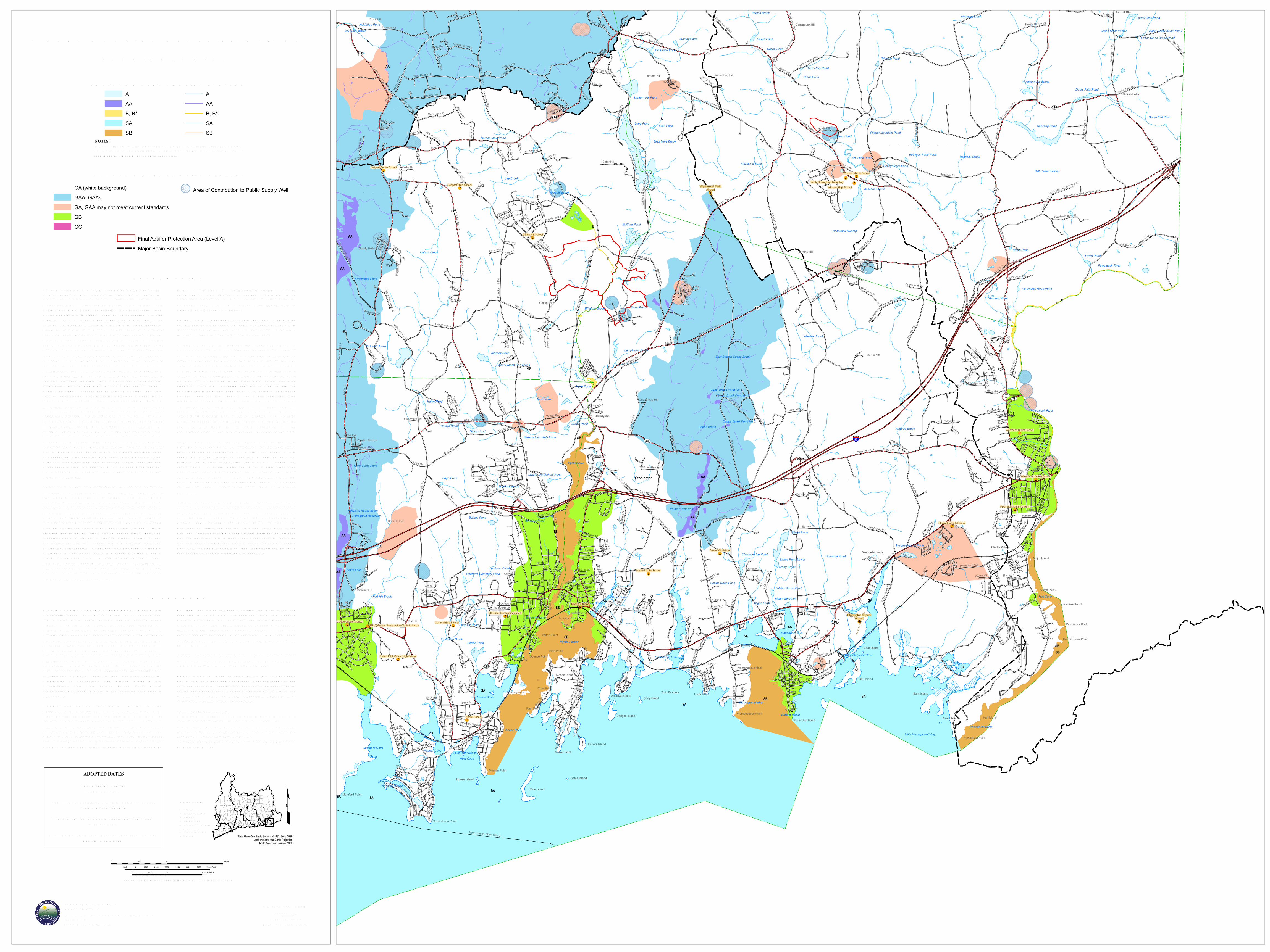
W ATER Q UALITY CLAS S IFICATIONSS TONINGTON, CT
SCALE 1:24,000 (1 inch = 2000 feet) when map is printed at original size
1 0 10.5 Miles
1 0 10.5 Kilometers
1000 0 1000 2000 3000 4000 5000 6000 7000 Feet
ADOPTED DATES
W ater Q uality S tandardsFebruary 25, 2011
Thames R iver, Pawcatuck R iver and Southeast CoastalBasins: December 1986
Connecticut R iver and South Central Coastal Basins:February 1993
Housatonic R iver, Hudson R iver and Southw est CoastalBasins: March 1999
S TATE OF CONNECTICUTDEPAR TMENT OFENER GY & ENV IR ONMENTAL PR OTECTION79 Elm S treetHartford, CT 06106-5127
State Plane Coordinate System of 1983, Zone 3526Lambert Conformal Conic Projection
North American Datum of 1983
MAJOR BASINS1 Paw catuck2 Southeast Coast3 Thames4 Connecticut5 South Central Coast6 Housatonic7 Southw est Coast8 Hudson
£
S UR FACE W ATER Q UALITY CLAS S ES
Final Aquifer Protection Area (Level A)Major Basin Boundary
GR OUND W ATER Q UALITY CLAS SES
NOTES:S urface W ater Classifications beginning w ith S refer to Coastal and Marine S urface W ater.B* is a subset of Class B where no direct w astew ater discharges are allow ed other than thoseconsistent with Class AA, A and SA surface w aters.
GA (white background)GAA, GAAsGA, GAA may not meet current standardsGBGC
Area of Contribution to Public Supply Well
AAAB, B*SASB
AAAB, B*SASB
EX PLANATIONW ATER Q UALITY CLAS S IFICATIONS (W Q C) MAPS are oneof the elements of the W ater Q uality S tandards (W Q S ) for theS tate of Connecticut. The W Q S are a part of Connecticut's cleanw ater program and are essential for protecting and improving waterquality. The W Q S follow the principles of Connecticut's CleanW ater Act which is in Chapter 446K of the Connecticut GeneralS tatutes. The W Q S provide policy guidance in many areas, forexample decisions on acceptable discharges to water resources,siting of landfills, remediation or prioritization of municipalsew erage system projects. The first two elements of the W Q S arethe S tandards, which set an overall policy for management of waterquality, and the Criteria, which are descriptive and numericalstandards that describe the allowable parameters and goals forvarious water quality classifications. A discussion of these twoelements is found in the W ater Q uality S tandards documentavailable on the CT DEEP website. The third element is theClassifications and the W ater Q uality Classification Maps whichshow the Classification assigned to each surface and groundw aterresource throughout the S tate. The W Q S are adopted using a publicparticipation process. The W Q C maps are also adopted using apublic participation process but go through hearings separatelyfrom the S tandards and Criteria hearings. R evision and adoption ofthe W Q C data occurs in accordance with the public participationprocedures contained in S ection 22a-426 of the ConnecticutGeneral S tatutes. Ground W Q C is subject to Connecticutregulation and changes must be review ed and adopted. All changesto the S urface W Q C require an adoption process which is subjectto federal review and approval in addition to CT regulation. Theadoption dates for the W Q C by major drainage basin are:Housatonic R iver, Hudson R iver and Southw est Coastal Basins -March 1999; Connecticut R iver and South Central Coastal Basins -February 1993; Thames R iver, Pawcatuck R iver and SoutheastCoastal Basins - December 1986. S urface W ater Classifications donot change after the adoption date until the next major revision.Ground W ater Classifications may change after the adoption dateunder specific circumstances. The map may have more than oneW Q C adoption date because a town may be in more than onemajor drainage basin.SUR FACE W ATER S in Connecticut are divided into freshw aterclassified as AA, A, B or B* and saline waters classified as SA orSB. Class AA designated uses are existing or proposed drink ingw ater supplies; habitat for fish and other aquatic life and wildlife;recreation; and water supply for industry and agriculture. Class Adesignated uses are habitat for fish and other aquatic life andw ildlife; potential drink ing water supplies; recreation; navigation;and water supply for industry and agriculture. Class SA designateduses are habitat for marine fish, other aquatic life and wildlife;shellfish harvesting for direct human consumption; recreation;industrial water supply; and navigation. Class B designated usesare habitat for fish and aquatic life and wildlife; recreation;navigation; and industrial and agricultural water supply. Class B*,applicable to Candlewood Lak e, is a subset of Class B and isidentical in all ways to the designated uses, criteria and standardsfor Class B waters except for the restriction on direct discharges.Class SB designated uses are habitat for marine fish and aquaticlife and wildlife; commercial shellfish harvesting; recreation;industrial water supply; and navigation.
S urface waters which are not specifically classified shall beconsidered as Class A or Class AA. S urface waters in GA groundw ater areas are assumed Class A or Class SA unless otherwiseindicated. S urface waters in GAA ground water areas are assumedClass AA unless otherwise indicated.On the W Q C map a surface water quality goal of A is representedby blue colored water bodies. S urface water quality goal of AA isrepresented by purple colored water bodies. S urface water qualitygoal of B is represented by gold colored water bodies.GR OUND W ATER S in Connecticut are classified as GAA, GA,GB and GC. Class GAA designated uses are existing or potentialpublic supply of w ater suitable for drink ing without treatment andbaseflow for hydraulically-connected surface water bodies. TheClass GAAs is a subclass of GAA for ground water that is tributaryto a public water supply reservoir. The area of contribution to apublic water supply well is represented by a 500-foot radius aroundthe well and is assumed to be Class GAA unless otherwiseclassified. Class GA designated uses are existing private andpotential public or private supplies of water suitable for drink ingw ithout treatment and baseflow for hydraulically-connectedsurface water bodies. All ground waters not specifically classifiedare considered as Class GA. Class GB designated uses areindustrial process water and cooling waters and baseflow forhydraulically-connected water bodies and is presumed not suitablefor human consumption without treatment. Class GC designateduses are assimilation of discharges authorized by theCommissioner pursuant to S ection 22a-430 of the General S tatutes.On the W Q C map GA is represented by white colored land areas.Class GAA and class GAAs are represented by blue colored landareas. The area of contribution to a public water supply well isshown by a blue cross-hatch overprint. A notation of GAAfollowed by a state abbreviation indicates a watershed thatcontributes to the public water supply for a state other thanConnecticut. Class GA or Class GAA areas that currently may notbe meeting the GA or GAA standards are represented on the W Q Cmaps by tan colored land areas. Class GB is represented by greencolored land areas. Class GC is represented by magenta coloredland areas.FINAL AQ UIFER PR OTECTION AR EAS (Level A) are includedon the W Q C maps for informational purposes. These areas areanticipated to be reclassified GAA during the next major basinupdates, subject to public participation. The Aquifer ProtectionProgram helps protect Connecticut’s public drink ing waterresources by delineating aquifer protection areas (also calledw ellhead protection areas) for public supply wells and establishingland use regulations within these areas. These areas represent theland area contributing ground water to active public water supplywells or well fields that serve more than 1000 people and are set insand and gravel aquifers (stratified drift deposits).
DATA SOUR CESW ATER Q UALITY CLAS S IFICATIONS DATA – W ater qualityclassifications shown on this map are based on information fromthe following digital spatial datasets that are typically showntogether – Ground W ater Q uality Classifications Poly, S urfaceW ater Q uality Classifications Line, and S urface W ater Q ualityClassifications Poly. The map legend above reflects the content ofthese three data sources. These W Q C data were initially compiledon 1:24,000-scale 7.5 minute USGS topographic quadrangle mapsand later digitized at 1:24,000 scale. For example, the S urfaceW ater Q uality Classifications Line and S urface W ater Q ualityClassifications Poly digital data assigns surface water qualityclassifications to water bodies such as rivers, streams, reservoirs,lak es, ponds and coves found in 1:24,000-scale hydrography dataavailable from CT DEEP. The hydrography may not include all thew aterbodies in Connecticut. The Ground W ater Q ualityClassifications Poly data assigns ground water qualityclassifications, at 1:24,000 scale, to the remaining land areas inConnecticut.AQ UIFER PR OTECTION AR EA DATA – Aquifer ProtectionAreas shown on this map are from the Aquifer Protection Areadigital dataset which contains polygon data intended to be used at1:24,000 scale. The dataset contains regulated areas classified asLevel A Aquifer Protection Area (Final) and Level B AquiferProtection Area (Preliminary). The Level B areas are not shown onthe W Q C maps. The data was collected from 1991 to the presentand is actively updated as Final area mapping replaces earlierPreliminary areas. The Aquifer Protection Areas are delineated by
the individual water companies owning the well fields andsubmitted to the CT DEEP for approval. Preliminary mappingprovides a general estimate of the area contributing ground waterto the well field. Final mapping is based on extensive, site-specific,detailed modeling of the ground water flow system. CT DEEP mayadjust Final area boundaries to be consistent with 1:24,000 scaletopography and base map data where appropriate during theapproval process.MAJOR DR AINAGE BASIN DATA – Major drainage basinsshown on this map are from Major Basin Line data developed byCT DEEP and intended to be used at 1:24,000 scale.BASE MAP DATA - Based on data originally from 1:24,000-scaleUSGS 7.5 minute topographic quadrangle maps published betw een1969 and 1992. It includes political boundaries, railroads, airports,hydrography, geographic names and geographic places. S treets andstreet names are from Tele Atlas® copyrighted data. Base mapinformation is neither current nor complete.R ELATED INFOR MATIONThis map is intended to be printed at its original dimensions inorder to maintain the 1:24,000 scale (1 inch = 2000 feet).W ATER Q UALITY S TANDAR DS - Go to the CT DEEP websitefor a summary and the full text of the “W ater Q uality S tandards”and for other information on water quality.AQ UIFER PR OTECTION AR EAS - Go to the CT DEEP websitefor more information.
Map created by CT DEEPOctober 2017Map is not colorfast
Protect from light and moisture


![q]Ý0m*l4mxl4`ó[ S:WßVóÿ `ó[ gY' j!ÿ...N N N N N N N N N N N N N N N N N N N N N N N N N N N N N N N N N N N N N N N N N N N N N N N N N N N N N N N N N N N N N N N N N N N N](https://img.pdfslide.tips/doc/110x75/61279995a965a5482e5f8607/q0ml4mxl4-swv-gy-j-n-n-n-n-n-n-n-n-n-n-n-n-n-n-n-n-n.jpg)


![maRé de CoNToS DanÇas...n [sexta-feira] n n n n n n n n n nJoaq n [sábado] n n [n n n n n n n n n n n n n A SOR n nPOESIA À LA CAR 17 DE OUTUBRO passam por criar hábitos de leitura](https://img.pdfslide.tips/doc/110x75/5f4ee8f81fa5bd53df78630d/mar-de-contos-danas-n-sexta-feira-n-n-n-n-n-n-n-n-n-njoaq-n-sbado.jpg)