Embed Size (px)
Citation preview

ACTA CLIMATOLOGICA ET CHOROLOGICA Universitatis Szegediensis, Tom. 34-35, 2001, 69-80.
ANALYSIS OF PRECIPITATION IN BAKONY MOUNTAINS
S. FOGARASI
Department of Climatology and Landscape Ecology, University of Szeged, P.O. Box 653. 6722 Szeged, Hungary
North-Transdanubian Waterwork Joint-Stock Company, P.O. Box 117, 2801 Tatabánya, Hungary E-mail: [email protected]
Összefoglalás - A munka a Dunántúli-középhegység karsztvízrendszerét képező Bakony csapadékviszonyait vizsgálta az 1991-95-ös időszakban. A csapadék fő jellemzőinek (időbeli eloszlás, intenzitás, makroszinoptikus helyzetek) meghatározása volt az első lépés. Ez alapján megállapítható, hogy a csapadékhullás a Bakonyban meglehetősen koncentrált. Ezt követően az 1990-es években bekövetkezett csapadéknövekedést vizsgálta a dolgozat. A folyamat okai jól elkülöníthetők a választott időszakban. A munka eredményeként megállapítható, hogy nem csupán a csapadék mennyiségi növekedése, hanem eloszlásának változása is segítette a karsztvíz rendszer regenerálódását. A csapadék növekedésének okait makroszinoptikus helyzetek szempontjából is értékeli a tanulmány. Summary - This paper presents the results of the research, which has analysed the precipitation of Bakony Mountains (part of Transdanubian karst system) between 1991 and 1995. At the same time we have studied the infiltration too. The first step was to study the temporal distribution of the heavy amount of precipitation (occurrence, intensity, macrosynoptic situations). Based on these data we have concluded, that the precipitation in this area is concentrated. As the next step of the investigation we have determined the causes of the increased amount of mean precipitation of the first half of 1990's. We could easily separate these in the studied period. It seems that this increase of precipitation is a part of a trend. By the the study we can conclude, that in the regeneration of karstwater-system of the Transdanubian Mountains not only the increasing of amount of precipitation played an important role, but the change of its temporal distribution too. The causes of this increase of precipitation were compared with macrosynoptic situations.
Key words: dry period, increasing of precipitation, macrosynoptic types, parameters of precipitation, main periods of precipitation
INTRODUCTION
The Transdanubian Mountains reserve large amount of karst water, which is supplemented by precipitation. Its exact budget is not yet well defined, because to determinate the amount of water input and output is very difficult. To determinate precisely the water budget, the climatological parameters of the area must be studied as well. Therefore, this work could have large importance in the infiltration researches.
We examined the data of the years 1991-95 at Bakonybél-Somhegypuszta climatological station.
The Bakony Mt. is only a part of the whole infiltration area (Lorberer, 1986). We have chosen this territory, because this is the only one region, where climatological stations exist even on higher altitudes with the necessary density. Therefore, the modelling of macrosynoptic situations, the resulted precipitation and the history of a single rain was
69

Sándor Fogarasi
possible. We have chosen this station, because it is in the centre of Bakony Mt., and all those climatological effects are mixed here, which are dominant in other climatological stations. For example at Farkasgyepű station the oceanic effects are dominant (the climate of Bakonybél is mostly similar to this point, but already transitional), whilst at Veszprém and Mencshely the Mediterranean ones. In the case of Zirc the climate is influenced by the geographical situation, as far as it is located in an enclosed basin. Therefore, this station is protected from the westerly and southerly winds causing interesting changes in temperature and precipitation. In the point of precipitation at Zirc the Mediterranean effects dominant. This statements are confirmed by the Mediterranean index of this climatological stations too (Koppány and Unger, 1992). Of course, these differences are inside the continental climate, prevailing in the Bakony. The continental effect is turn into strong in the closed basins, and the mountain is appearing at the tops and plates of Bakony. We have chosen this period, because it both involves the dry period, which started at the end of the 1970's, and the wet period, which started at the autumn of 1993. The other reason was, that the radical changes in the measurement system of meteorological stations took place later, only after 1995.
DETERMINATION OF THE MAIN PERIODS OF PRECIPITATION
It is a fundamental question, whether we can typify the activity of precipitation and whether there is such macrosynoptic situation, which mostly determinates the quantity of precipitation.
The mean precipitation at the chosen meteorological station was 827 mm between 1901-50, but between 1951-1998 it was only 784 mm. It was 755 mm in the examined 5 years. In the driest year only 683 mm precipitation was detected, but during the wettest year it was 871 mm (Table 5).
According to our study in 43-44% of the days out of the year can be considered as rainy at 400 m a.s.l. in the study area. This value varies only slightly year by year, and it means that 2 days out of 5 are rainy. Contrary, on most of these wet days the precipitation is not heavy (it remains below 5 mm/day). Heavy quantity of precipitation occurs only on the 31% of the wet days (Table 1).
Table 1 The distribution of the different amount of precipitation by classes (mm/day) in days within the wet days (%)
Classes Under 0.5 mm 0.5-5 mm 5-10 mm Above 10 mm % 20 49 16 15
It means, that heavy amount of precipitation occurs mostly in well-defined periods.
But it is more important question what is the proportion of yearly precipitation on these wet days. Using this approach, the 79% of the total amount of precipitation of the investigated five years were measured on those days, which received more than 5 mm precipitation (Table 2).
Table 2 The portion of the different amount of precipitation classes within the mean precipitation (%) Classes Under 5 mm 5-10 mm Above 10 mm
% 21 23 56
70

Analysis of precipitation investigation in the Bakony Mountains
According to these data 79% of the total precipitation is realised on the 31% of the wet days, which is only 1/7-1/8 part of the whole investigated period. We can conclude, that the precipitation is very concentrated in time. Based on these results, in the following we examine the precipitation over 5 mm/day.
The following step of the investigation was the determination of that Péczely’s macrosynoptic situations (Péczely, 1961), which caused heavy amount of precipitation. The Károssy’s classification was used as source (Károssy, 1998) (Table 3).
Table 3 Macrosynoptic situations according to Péczely (1983)
Number of macrosynoptic situation
Code of macrosynoptic situation
Description of macrosynoptic situation
1 mCc Hungary is in the rear of an East European cyclone
2 AB Anticyclone over the British Isles 3 CMc Hungary is in the rear of a Mediterranean
cyclone 4 mCw Hungary lies in the fore part of a West
European cyclone 5 Ae Anticyclone east of Hungary 6 CMw Hungary lies in the fore part of a Mediterranean
cyclone 7 Zc Zonal, cyclonic 8 Aw Anticyclone extending from the west 9 As Anticyclone south of Hungary
10 An Anticyclone north of Hungary 11 AF Anticyclone over the Fennoscandinavian region 12 A Anticyclone over the Carpathian Basin 13 C Cyclone over the Carpathian Basin
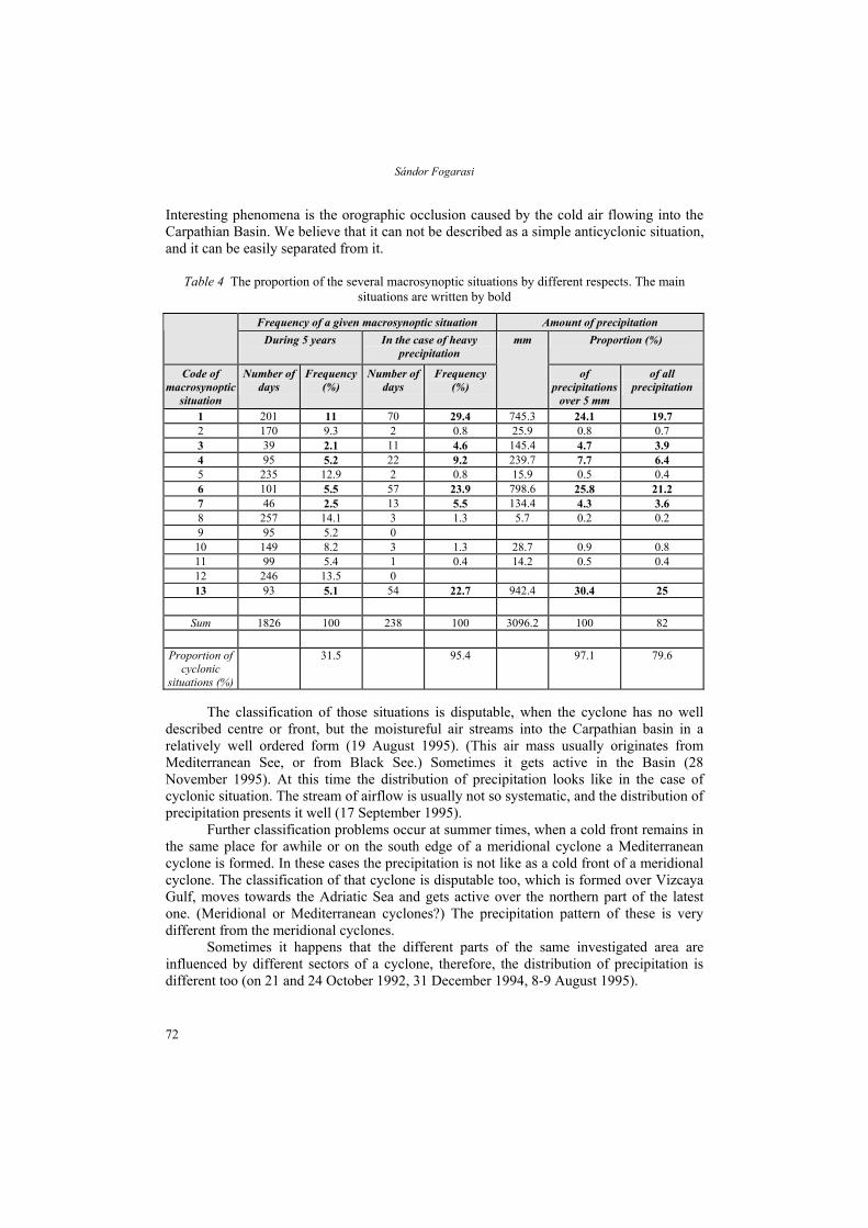
By this approach the precipitation seems even more concentrated in time (Table 4).
Studying the table one could see that cyclonic situations occurs in one third of the whole period, but during this time occurs 95.4% of the days with heavy precipitation (over 5 mm/day). Therefore, they occur at this time 97.1% of heavy precipitation. This is the 79.6% of sum of precipitation. (This value could be larger, because we did not calculate with the precipitation below 5 mm/day.)
During the classification of macrosynoptic situations some problems rise. The most typical difficulty originates from the European macrosynoptic situation, which presents anticyclonic field for Carpathian Basin. But in contrary, it is on the edge of this field; therefore, the weather is controlled by a cyclone. In these frequent cases the centre of the anticyclones is situated over the British Isles, and it is converted to the whole Carpathian Basin too. But on the edge of this anticyclone is a moving cold front, with regular cloud system. In these cases Hungary receives heavy amount of precipitation, with a distribution like of the meridional cyclone's cold front. The situation is similar, when north of Carpathian Basin is an anticyclone, so the country is situated on its southern edge, while over the Balkan Peninsula a Mediterranean cyclone is formed. Its result is a large amount of precipitation, which carries the characteristics of a warm sector of a Mediterranean cyclone.
71
Sándor Fogarasi
Interesting phenomena is the orographic occlusion caused by the cold air flowing into the Carpathian Basin. We believe that it can not be described as a simple anticyclonic situation, and it can be easily separated from it.
Table 4 The proportion of the several macrosynoptic situations by different respects. The main situations are written by bold
Frequency of a given macrosynoptic situation Amount of precipitation During 5 years
In the case of heavy
precipitation Proportion (%)
Code of macrosynoptic
situation
Number of days
Frequency (%)
Number of days
Frequency (%)
mm
of precipitations
over 5 mm
of all precipitation
1 201 11 70 29.4 745.3 24.1 19.7 2 170 9.3 2 0.8 25.9 0.8 0.7 3 39 2.1 11 4.6 145.4 4.7 3.9 4 95 5.2 22 9.2 7.7 6.4 5 235 12.9 2 0.8 15.9 0.5 0.4 6 101 5.5 57 23.9 798.6 25.8 21.2 7 46 2.5 13 5.5 134.4 4.3 3.6 8 257 14.1 3 1.3 5.7 0.2 0.2 9 95 5.2 0 10 149 8.2 3 1.3 28.7 0.9 0.8 11 99 5.4 1 0.4 14.2 0.5 0.4 12 246 13.5 0 13 93 5.1 54 22.7 942.4 30.4 25
Sum 1826 100 238 100 3096.2 100 82
Proportion of
cyclonic situations (%)
31.5 95.4 97.1 79.6
239.7
The classification of those situations is disputable, when the cyclone has no well
described centre or front, but the moistureful air streams into the Carpathian basin in a relatively well ordered form (19 August 1995). (This air mass usually originates from Mediterranean See, or from Black See.) Sometimes it gets active in the Basin (28 November 1995). At this time the distribution of precipitation looks like in the case of cyclonic situation. The stream of airflow is usually not so systematic, and the distribution of precipitation presents it well (17 September 1995).
Further classification problems occur at summer times, when a cold front remains in the same place for awhile or on the south edge of a meridional cyclone a Mediterranean cyclone is formed. In these cases the precipitation is not like as a cold front of a meridional cyclone. The classification of that cyclone is disputable too, which is formed over Vizcaya Gulf, moves towards the Adriatic Sea and gets active over the northern part of the latest one. (Meridional or Mediterranean cyclones?) The precipitation pattern of these is very different from the meridional cyclones.
Sometimes it happens that the different parts of the same investigated area are influenced by different sectors of a cyclone, therefore, the distribution of precipitation is different too (on 21 and 24 October 1992, 31 December 1994, 8-9 August 1995).
72

Analysis of precipitation investigation in the Bakony Mountains
We have thought, that these situations are falling under the other categories so we reclassified these. In these cases the amount of precipitation was 20% of the sum of precipitation, and 29% of the heavy (over 5 mm/day) precipitation. Therefore, we believe that we should find a new way in reclassification of macrosynoptic types of Carpathian Basin (Table 5).
Some problem can be solved with Bodolainé’s characterisation (Bodolainé, 1983). (E.g. the “Cold air trough” category we can range to the most of the discussed situation, when there is anticyclone north or east of Hungary, and developing heavy precipitation.) But this classification we could not used, because we had not special data, need to this, and categories covering only the situations with extremely large precipitation, mainly in the summer half-year.
After finishing of this research we red a new study in this theme (Hirsch, 2000). By this work it seems, that M and Ms type is equivalent with the two of our problematical situation. (Passing cold front turn into Mediterranean cyclone and “Mediterranean cyclone”, moved from Vizcaya Gulf.) By the two research could be registered the seasonable and spatial differences in case of heavy precipitation in Hungary.
We compared these problematical situations with Herz and Brezowsky (Gerstengarbe and Werner, 1993) characterisation, and examined the weather in Hungary during these types (Bartholy and Kaba, 1987). We found, that this characterisation is much more sensible and we can take by this the problematical situations to other categories. Thus in our opinion the Hess-Brezowsky types the better to the characterisation in Hungary, too.
Another problem derives from the rapid changes of weather, when during one single day two macrosynoptic situations occur. In this case it is difficult to distinguish the precipitation between these two.
Table 5 The distribution of heavy precipitation (over 5 mm/day) by macrosynoptic types (%)
Year Macrosynoptic types
1991 1992 1993 1994 1995 Mean of 5 year
1 15.2 23.4 26.3 21.4 13.3 19.9 3 1.6 1.1 2.2 3.1 10 3.6 4 9.9 3.3 9 6.4 3.8 6.5 6 18.2 14.4 26.7 24.7 21.2 21 7 0.9 3.4 1 3.6 8 3.4 13 32.7 31.7 15.1 17.9 27.9 25.1 Sum 78.5 77.3 80.2 77 84.2 79.4 Sum of heavy precipitations (cyclonic and non cyclonic too)
81.6 78.4 82.1 80.3 86.7 81.8
Yearly precipitation (mm) 683 715.8 756.9 748.4 870.7 755
The Table 5 shows, that in some of the cyclonic situations caused heavy precipitation, and other situations caused very small amount of precipitation. Most of the yearly precipitation is resulted by three macrosynoptic types: No. 1, No. 6 and No. 13. (These refer to the rear front of a meridional cyclone, to the fore part of a Mediterranean cyclone and to a cyclone-centre situation.) They do not occur more often than the other cyclonic situations with the exception of No. 1. But if they appear in the region they frequently cause heavy and intensive precipitation. This statement is not right for the No. 1 situation, but it is much true for No. 6 and No. 13. From the point of precipitation the No. 3, No. 4 and No. 7 situations could be considered as “complementary" ones. (These refer to the cold front of a Mediterranean cyclone, to the warm front of a meridional cyclone and to
73

Sándor Fogarasi
zonal cyclone.) Their incidence is little bit lower, than of the members of the above mentioned group (No. 6 and No. 13), but they cause smaller proportion and lower intensity of heavy precipitation. The No. 1 situation carries the characteristics of both groups. When it appears it usually causes small amount of precipitation just like the No. 3, No. 4 and No. 7 types, and its intensity is very similar to this group. But at the same time it prevails very often, and as its result, the amount of precipitation due to this situation is very similar to the proportion of No. 6 and No. 13. So we think, that the No. 1 type is falling in the same group with these two.
We must mention that some of anticyclonic situations cause more precipitation than certain cyclonic ones. It is true even after corrections (i.e. after re-coding some cyclonic situations, which were previously considered as anticyclonic). It caused by the fact, that some anticyclonic situations form such currents, where the conditions are very favourable for precipitation formation. If we study these situations, we can state that − besides the case of centre above the Carpathian Basin − in every anticyclonic situation some heavy precipitation was measured in the studied period. But the wet of the No. 2, No. 10-11 situations rises (i.e. anticyclone over the British Isles, anticyclone north of Hungary and anticyclone over the Fen-Scandinavian region). Their relatively high precipitation can be explained by different causes. The No. 2 situation causes precipitation during summer time, as far as in this situation moistureful, unstable current arrives from the Mediterranean region to the Carpathian Basin. It causes local showers, thunderstorms. The No. 10 and No. 11 situations produce large amount of precipitation in winter lasting for several days. It can be explained by that the cold air in their current is mixed with the warm air within the Basin (No. 10 situation), or with the warm and wet air masses of a Mediterranean cyclone situated south of Hungary (No. 11 situation). If this mixture of air masses is enough strong, it will result an occlusion front and the formation of a cyclone (No. 10 situation), or formation of a Mediterranean cyclone or movement of it to the Carpathian Basin (No. 11 situation). If these processes are not enough well defined and systemathical, we should classify these situations as anticyclonal, though, they result heavy amount of precipitation.
EXAMINATION OF THE PARAMETERS OF THE PRECIPITATION
From the above presented data one can see, that the amount of precipitation during the examined five years was increased continuously (only in 1994 was a slight decrease, but then it increased considerably) (Table 5). It arises the questions that (1) what caused this increasing tendency and (2) which parameters changed simultaneously.
First of all we considered that the increase of mean precipitation followed the increasing number of cyclonic situations simultaneously (Fig. 1). But the latest one did not cause the increase of precipitation. The appearance of cyclonic situation was the rarest in the first, dry year (1991), then it became more abundant for a while, but later the number of its appearance decreased again, thus, in the last year (1995) its number was almost like in 1991. This statement is right for the No. 6 and No. 13 situations, which result most of the precipitation. The No. 1 is exception of it, but after 1994 this showed well-defined decrease too. Thus, the frequency of No. 1, No. 6 and No. 13 situations followed the changes in number of cyclonic situations. The budget of the five years and the number of cyclonic macrosynoptic situations stagnated. The result, if we try to connect the number of different
74

Analysis of precipitation investigation in the Bakony Mountains
macrosynoptic situations with the yearly precipitation, that there is not relationship between them.
0
20
40
60
80
100
120
140
1991 1992 1993 1994 1995
year
num
ber
1
3
4
6
7
13
All cyclonic types
Annual sum of precipitation/10
Fig. 1 Variation of the number of different macrosynoptic types and the annual sum of precipitation
(mm), between 1991-1995
Between the number of wet days and the mean precipitation is a direct proportion, which can be demonstrated well using the number of days with the heavy precipitation (over 5 mm/day) instead of the number of wet days (Fig. 2). The number of wet days or the day with heavy precipitation changes simultaneously with the amount of yearly precipitation with the exception of the year 1991. This relationship between the number of wet days and yearly precipitation is strong since 1993, but it can be considered as rather strong connection since 1992 between the heavy and yearly precipitation respectively. In this last case the relationship is strong enough to identify certain macrosynoptic situations too.
0
10
20
30
40
50
60
70
80
90
100
1991 1992 1993 1994 1995
year
num
ber
Days with precipitation
Days with more than 5 mmprecipitation
Annual sum of precipitation/10
Fig. 2 Variation of the number of days with different amount of precipitation and the annual sum of
precipitation (mm), between 1991-1995
75

Sándor Fogarasi
After comparison the distribution of days with heavy precipitation with the number of different macrosynoptic situations, in the case of No. 13 and No. 6 situations we have found out that the number of days with heavy precipitation changed with the yearly precipitation after the year of 1992 (Fig. 3). However, there is no tendency between the changes in the number of days with heavy precipitation and the yearly precipitation in the case of No. 1 situation, similarly to the other situations. (The only one exception is the No. 3, but it caused only small amount of precipitation.)
0
10
20
30
40
50
60
1991 1992 1993 1994 1995
year
num
ber
6+13
1+6+13
3+4+7
All cyclonic types
Annual sum of precipitation/20
Fig. 3 Variation of the number of cases with precipitin over 5 mm/day by the cyclonic types and the
annual sum of precipitation (mm) between 1991-1995
The causes of the increase in number of all days with heavy precipitation can be well defined at the centre and at the end of the studied period. The increase in the number of those situations (i.e. No. 1, No. 6 and No. 13), that resulted most of the precipitation, increased at the centre of the period and it can be connected with the short stagnating period of 1994. But the increase in number of days with heavy precipitation during the wettest year of 1995 is in relationship with those cyclonic situations (i.e. No. 3-4 and especially No. 7) which caused small amount of precipitation previously. So, there is an ordinal relation, but the changes are influenced by other causes, too. These are as follows.
The proportion of the above mentioned two parameters (i.e. the number of different situations and the number of their heavy precipitation days) is the “wetness" of a situation. This is an intensity value of the precipitation (Fig. 4). The “wetness" of all cyclonic situations correlates with the number of days with heavy precipitation, and since 1992 with the yearly precipitation as well. The year of 1991 is an exception from this point too: certain situations were disproportionately rainy in comparison with the yearly precipitation. (But, as we have already mentioned in this year the number of those cyclonic situations, which usually caused precipitation was very low.) The changes of different macrosynoptic situations show even larger differences than in the case of the previous parameter. The distribution of No. 3-4 and No. 7 situations is very similar to the distribution of the number of days with heavy precipitation, and their number largely increased in 1995. The wetness of No. 6 and No. 13 situations decreased until 1993, but than it increased considerably. The No.1 situation shows different distribution. Their total wetness (No. 1, No. 6 and No. 13) is changes with the days with heavy precipitation, as well as of No. 3-4 and No. 7 situations.
76

Analysis of precipitation investigation in the Bakony Mountains
It means, that the cause of the increasing of the precipitation was the growing "wetness" (intensity value) of the different macrosynoptic situations, not their number.
0
10
20
30
40
50
60
70
80
90
100
1991 1992 1993 1994 1995
year
prop
ortio
n
6+13
1+6+13
3+4+7
Sum of cyclonic types
Annual sum of precipitation/10
Fig. 4 Variation of the proportion of the cases with precipitation over 5 mm/day by the cyclonic
types and the annual sum of precipitation (mm) between 1991-1995
The analysis of the average of precipitation of the heavy precipitation days (of certain macrosynoptic types) gives an intensity value too (Fig. 5). This value changed slightly in the case of total cyclonic precipitation: it was very high in the first two year, than after a decrease it stagnated and later it increased a while. But if we study this value in every single macrosynoptical type, we can conclude that it is very varied. It is especially right for those situations, which caused very high intensity precipitation (No. 6, No. 13 and in some cases No. 3 and No. 7). One out of these situations is cyclone-centres (resulting most of the precipitation of the Carpathian Basin) and two are Mediterranean cyclone. The average intensity of precipitation of these two athmospheric phenomena changed complementary. The precipitation intensity of meridional cyclons (No. 1 and No. 4) has changed more slightly in the examined period. The intensity of heavy precipitation resulted by No. 1, No. 6 and No. 13 situations is decreased during the analysed period, but it increased in the case of No. 3-4 and No. 7 situations respectively. Thus, the precipitation intensity of these two groups changed complementary, therefore, it resulted a slight decrease of precipitation intensity. (This decrease can be explained as it follows: though the intensity of the second group grew rapidly and it decreased only slightly in the case of the first group, but this latest group − i.e. No. 1, No. 6 and No. 13 − results most of the precipitation.) However, this general recession does not mean that heavy storms and precipitation are rare. (The largest precipitation intensity was recorded in 1995!)
During cyclonic situations the intensity values are mostly higher than the values of the all heavy precipitation. It means, that the cyclonal conditions results larger intensity of precipitation than the local effects, thus, the larger amount of precipitation in the Bakony Mt. is always in connection with cyclonic situations. The only one exception was in 1991. In this year the anticyclonal situations played important role in the formation of precipitation, and the average of their heavy precipitation was larger, so it were more intensive, than of the cyclons in the same year.
77

Sándor Fogarasi
0
5
10
15
20
25
1991 1992 1993 1994 1995
year
quan
tity
3+4+7
1+6+13
All cyclonic types
All precipitation
Annual sum of precipitation/40
Fig. 5 Variation of the average intensity (mm) of the precipitation over 5 mm/day by the cyclonic
types and the annual sum of precipitation (mm) between 1991-1995
THE CAUSES OF THE INCREASE OF PRECIPITATION
First of all we have to find the causes of the dry weather of the first year. In 1991 the number of cyclonic situation was very low, but at the same time the number of wet days was considerably large. It means, that the rare cyclonical situations caused precipitation in larger proportion. But the number of heavy precipitation was very low, though in these rare cases the precipitation intensity was the second largest within the studied period. It is worth to note, that relatively large proportion of the heavy precipitation was realised in anticyclonical situations.
In the next year (1992) the number of the cyclonic situations was increased rapidly reaching its maximum value, but the number of the wet days, and heavy precipitation days reached the lowest number within the 5 years. Thus, the abundant cyclonic situations caused precipitation only sometimes, but the intensity of heavy precipitation reached its maximum value. These resulted larger amount of mean precipitation than it was in the former year. In this year the cause of increased amount of precipitation is the increased intensity of heavy precipitation.
In 1993 new processes started, which lasted until the end of the examined period. The number of the cyclonic situations reduced, but the number of wet days – and the heavy precipitation too – increased. It means, that the frequency of wetness grew. As the amount of precipitation was growing the No. 13 situation became more abundant. Mainly it caused, that the group of No. 1, No. 6 and No. 13 situations resulted more precipitation too. The increased amount of mean precipitation in 1993 we can be explaining with growing of wetness of this group.
At the same time the intensity of the heavy precipitation was significantly reduced. Therefore we supposed that the increase of mean precipitation had other causes than in the previous year. After this reduced the intensity of heavy precipitation a little bit increased, but the value was almost the same as it was before.
78

Analysis of precipitation investigation in the Bakony Mountains
These processes existed during the rest of the studied period, but in the 1994 they were temporarily stopped. It shows relationship with a slight decrease of yearly precipitation. But the increased amount of mean precipitation in 1995 can be explained by the increasing wetness of group No. 3-4 and No. 7 situations. The new research (Hirsch, 2000) confirmed too, that the 4 and 7 situations antecedents of types with considerable precipitation. Although its precipitation is not large, it seems there is not large yearly precipitation without these.
We think, that the increase of precipitation is part of a process. The causes of the changes can be justified by the combination of the analysed parameters.
It seems, that at the beginning the cause of increased precipitation is the increasing of cyclonic situations, and henceforth their growing intensity (first of the No. 1, No. 6 and No. 13 group, than after of the No. 3-4 and No. 7).
As a result the yearly precipitation was increased, and the number of heavy precipitation became larger too, but their intensity was decreased.
We must be careful when extrapolate these result for longer periods, because the examined period was too short, but may be the changes of this examined parameters show the shift of weather from a dry to a wet period. The same changes in precipitation and infiltration were observed all over Transdanubian Mountains since autumn of 1993. This autumn and the subsequent winter were much wetter than the average of the previous years.
CONCLUSIONS
Based on this analysis we could conclude that the occurrence of heavy precipitation and the prevailing macrosynoptic situations are temporally very concentrated in the Bakony Mountain.
In the examined period the mean precipitation was increased. The causes of these processes were very complex, and they differed in the first half and the second half of the studied period, the latest means the end of the dry period. Within this second half two crucial points could be distinguished. The continuous increase of precipitation seems to be a part of a process. It is probable that the different studied parameters and the mean precipitation changes similarly even during a longer period, therefore they could indicate the longer dry and wet years.
The number of heavy precipitation and the yearly precipitation were changed simultaneously, but the intensity of the first one was reduced. It means, that both the frequency of precipitation under 5 mm/day and the extremely high precipitation were reduced. It is well known, that from the point of infiltration booth extremities are not favourable. Therefore, not only the increasing precipitation, but also its changing intensity played an important role in the quick regeneration of the karst-water system of Transdanubian Mountains.
This analysis should be continued. We have to study whether these statements are valid for previous periods, and in what extent they continued after 1995.
79

Sándor Fogarasi
REFERENCES
Bartholy, J. and Kaba, M., 1987: A Hess-Brezowsky-féle makroszinoptikus típusok meteorológiai-statisztikai elemzése és korrekciója. (The meteorological-statistical analysis and correction of Hess-Brezowsky's macrosynoptical types.) Meterorológiai Tanulmányok No. 57, OMSZ, Budapest.
Bodolainé, J. E., 1983: Árhullámok szinoptikai feltételei a Duna és a Tisza vjzgyűjtő területén. (Synoptical Conditions of Flood-Waves on the Basin of the Danube and the Tisza.) OMSZ Hivatalos Kiadványai, LVI. Kötet, OMSZ, Budapest.
Felméry, L., Péczely, Gy. and Ruthner-Zách, M., 1971: Tanulmány a Bakony éghajlatáról. (Study of the climate of the Bakony Mountains). Budapest.
Gerstengarbe, F-W. and Werner C., P., 1993: Katalog der Groβwetterlagen Europas nach Paul Hess ung Helmuth Brezowsky 1881-1992. Selbstverlag des Deutschen Wetterdienstes, Offenbach am Main.
Hirsch, T., 2000: Synoptic-climatological investigation of weather systems causing heavy precipitation in winter in Hungary. Időjárás 104, 173-196.
Koppány, Gy. and Unger, J., 1992: Mediterranean climatic character in the annual march of precipitation. Acta Climatologica Univ. Szegediensis 24-26, 59-71.
Károssy, Cs., 1998: A Kárpát-medence Péczely-féle makroszinoptikus helyzeteinek katalógusa (1983-1995). (Catalogue of the Peczely's macrosynoptic weather types of the Carpathian Basin in 1983-1995.) Földrajzi Kaleidoszkóp, Tanulmányok Krajkó Gyula professzor 70. születésnapjára, 330-334.
Lorberer, Á., 1986: A Dunántúli-középhegység karsztvízföldani és vízgazdálkodási helyzetfelmérése és döntéselőkészítő értékelése, I. Összefoglaló jelentés. (The hydrogeological and hydrological research of the Transdanubian Mountains, First Part.) VITUKI, Budapest.
Péczely, Gy., 1961: Magyarország makroszinoptikus helyzeteinek éghajlati jellemzése (Climatological characterization of the macrosynoptic types of Hungary.) Országos Meteorológiai Intézet Kisebb Kiadványai No. 32, Budapest.
Péczely, Gy., 1962: A 80 mm-t meghaladó napi csapadék gyakorisága Magyarország területén. (Frequency of precipitation above 80 mm/day in Hungary.) Időjárás 66, 197-204.
Péczely, Gy., 1983: Magyarország makroszinoptikus helyzeteinek katalógusa (1881-1983). (Catalogue of macrosynoptic types of Hungary (1881-1983)). Országos Meteorológiai Szolgálat Kisebb Kiadványai No. 53, Budapest.
80