Embed Size (px)
Citation preview
Concluding Report ariffin mahamud
1
Action Plan toward Effective Flood Hazard
Mapping in My Country in Malaysia (Concluding report)
JICA region focused training course on flood hazard mapping
JFY 2006
Ariffin Mahamud
Hydrology and Water Resources Division Department of Irrigation and Drainage
MALAYSIA KM 7, Jalan Ampang, 68000 Ampang, Kuala Lumpur
Tel. 03-42552609 Fax: 03-42563735
Email address: [email protected]
Concluding Report ariffin mahamud
2
A. THE ROLE OF FLOOD HAZARD MAPS TO MITIGATE FLOOD DAMAGES IN MALAYSIA
Flood Status in Malaysia
1. Flood is the most significant natural disaster in Malaysia in terms of frequency,
inundated areas, population affected and economical loss. It has been estimated
9% of land area (29, 800 km2) in the country is flood prone areas, 22 % of the
population (4.82 million) is affected by floods and the average annual flood
damage is about RM 1 billion.
2. Heavy rainfall during North East Monsoon affecting the east coast of Peninsular
Malaysia (widespread flood). Intense rainstorms during inter monsoon periods of
April-May and August-October causing flash floods in major towns such as Kuala
Lumpur and Johor Bharu.
3. Climate and Topography in Malaysia
- Annual average rainfall
Peninsular Malaysia: 2500 mm
Sabah: 3000 mm
Sarawak: 3500 mm
- Extreme events
600 mm in 24 hours
100 – 200 mm in 2 hours
- Topography
i. Hilly upper reaches
ii. Normal sloping middle reaches (1 in 2,000)
iii. Gentle sloping lower reaches (less than 1 in 5,000)
iv. Mostly subject to tidal influence downstream
v. Shallow river bed in flood plain due to sedimentation
vi. High tidal influence can cause flooding in coastal areas
Concluding Report ariffin mahamud
3
Year
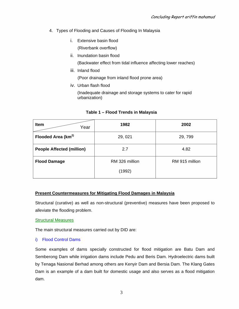
4. Types of Flooding and Causes of Flooding In Malaysia
i. Extensive basin flood
(Riverbank overflow)
ii. Inundation basin flood
(Backwater effect from tidal influence affecting lower reaches)
iii. Inland flood
(Poor drainage from inland flood prone area)
iv. Urban flash flood
(Inadequate drainage and storage systems to cater for rapid urbanization)
Table 1 – Flood Trends in Malaysia
Item 1982 2002
Flooded Area (km2) 29, 021 29, 799
People Affected (million) 2.7 4.82
Flood Damage RM 326 million
(1992)
RM 915 million
Present Countermeasures for Mitigating Flood Damages in Malaysia
Structural (curative) as well as non-structural (preventive) measures have been proposed to
alleviate the flooding problem.
Structural Measures
The main structural measures carried out by DID are:
i) Flood Control Dams
Some examples of dams specially constructed for flood mitigation are Batu Dam and
Semberong Dam while irrigation dams include Pedu and Beris Dam. Hydroelectric dams built
by Tenaga Nasional Berhad among others are Kenyir Dam and Bersia Dam. The Klang Gates
Dam is an example of a dam built for domestic usage and also serves as a flood mitigation
dam.
Concluding Report ariffin mahamud
4
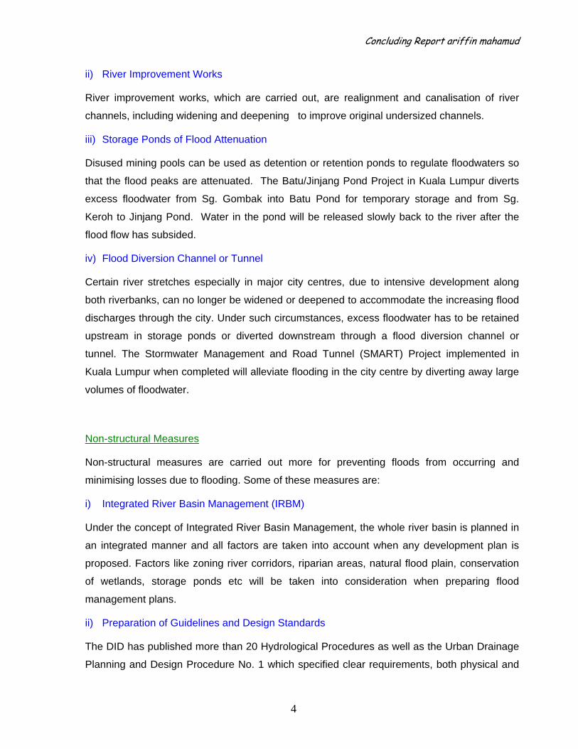
ii) River Improvement Works
River improvement works, which are carried out, are realignment and canalisation of river
channels, including widening and deepening to improve original undersized channels.
iii) Storage Ponds of Flood Attenuation
Disused mining pools can be used as detention or retention ponds to regulate floodwaters so
that the flood peaks are attenuated. The Batu/Jinjang Pond Project in Kuala Lumpur diverts
excess floodwater from Sg. Gombak into Batu Pond for temporary storage and from Sg.
Keroh to Jinjang Pond. Water in the pond will be released slowly back to the river after the
flood flow has subsided.
iv) Flood Diversion Channel or Tunnel
Certain river stretches especially in major city centres, due to intensive development along
both riverbanks, can no longer be widened or deepened to accommodate the increasing flood
discharges through the city. Under such circumstances, excess floodwater has to be retained
upstream in storage ponds or diverted downstream through a flood diversion channel or
tunnel. The Stormwater Management and Road Tunnel (SMART) Project implemented in
Kuala Lumpur when completed will alleviate flooding in the city centre by diverting away large
volumes of floodwater.
Non-structural Measures
Non-structural measures are carried out more for preventing floods from occurring and
minimising losses due to flooding. Some of these measures are:
i) Integrated River Basin Management (IRBM)
Under the concept of Integrated River Basin Management, the whole river basin is planned in
an integrated manner and all factors are taken into account when any development plan is
proposed. Factors like zoning river corridors, riparian areas, natural flood plain, conservation
of wetlands, storage ponds etc will be taken into consideration when preparing flood
management plans.
ii) Preparation of Guidelines and Design Standards
The DID has published more than 20 Hydrological Procedures as well as the Urban Drainage
Planning and Design Procedure No. 1 which specified clear requirements, both physical and
Concluding Report ariffin mahamud
5
technical, for rivers and their reserves, as well as flood mitigation and urban drainage projects
to be used as reference materials and guidelines.
In the year 2000, DID introduced the Urban Stormwater Management Manual (MASMA) which
obtained Cabinet (central government) approval for implementation commencing 1 January
2001 and is to be complied with by all local authorities and the public and private sectors. The
Manual provides control-at-source measures and recommendations on flood fighting by
utilising detention/retention, infiltration and purification processes.
iii) Flood Forecasting and Warning System
Telemetric forecasting systems have been installed in the major river basins namely Kelantan,
Pahang, Perak, Sadong, Kinabatangan, Klang, Terengganu, Besut, Dungun, and Johor whilst
VHF flood forecasting systems have been established in smaller basins. In river basins prone
to flash floods, flood warning sirens have been installed at strategic locations along certain
urban rivers. These sirens will be automatically triggered once the flood level reaches a critical
point to alert the local residents of impending floods. The Department also provides a web-
based information system on flood warning and flood information through
http://infobanjir.water.gov.my
Flood response will be functional after the flood event occurs especially during the monsoon
season. It’s included with the five main activities as below:
i. ‘Pre’ flood, ‘During’ flood and ‘Post’ flood
ii. Flood forecasting and warning system
iii. Flood disaster management, flood fighting, evacuation
iv. Flood operation and relief centres at District, State and Federal levels
v. Flood damage assessment
Flood Hazard Map In Malaysia
•• AAss aa nnoonn--ssttrruuccttuurraall mmeeaassuurreess,, FFlloooodd HHaazzaarrdd MMaapp iiss vveerryy uusseeffuull aanndd bbeenneeffiicciiaall ttoo tthhee ppooppuullaattiioonn..
• FHM which includes information on INUNDATION areas, EVACUATION centres and ALTERNATIVE routes in an easy-to-understand way where people can evacuate in a SAFE, SMOOTH and QUICK manner when disasters are anticipated to occurr
•• TThhee mmaappss aarree pprroodduucceedd ffoorr ppuubblliicc aawwaarreenneessss ttoo ddeeaall wwiitthh tthhee pprroobblleemmss aanndd ssiittuuaattiioonn dduurriinngg ffllooooddss..
.
Concluding Report ariffin mahamud
6
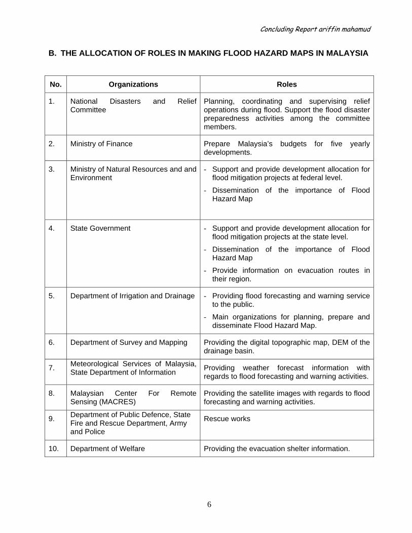
B. THE ALLOCATION OF ROLES IN MAKING FLOOD HAZARD MAPS IN MALAYSIA
No. Organizations Roles
1. National Disasters and Relief Committee
Planning, coordinating and supervising relief operations during flood. Support the flood disaster preparedness activities among the committee members.
2. Ministry of Finance Prepare Malaysia’s budgets for five yearly developments.
3. Ministry of Natural Resources and and Environment
- Support and provide development allocation for flood mitigation projects at federal level.
- Dissemination of the importance of Flood Hazard Map
4. State Government - Support and provide development allocation for flood mitigation projects at the state level.
- Dissemination of the importance of Flood Hazard Map
- Provide information on evacuation routes in their region.
5. Department of Irrigation and Drainage - Providing flood forecasting and warning service to the public.
- Main organizations for planning, prepare and disseminate Flood Hazard Map.
6. Department of Survey and Mapping Providing the digital topographic map, DEM of the drainage basin.
7. Meteorological Services of Malaysia, State Department of Information Providing weather forecast information with
regards to flood forecasting and warning activities.
8. Malaysian Center For Remote Sensing (MACRES)
Providing the satellite images with regards to flood forecasting and warning activities.
9. Department of Public Defence, State Fire and Rescue Department, Army and Police
Rescue works
10. Department of Welfare Providing the evacuation shelter information.
Concluding Report ariffin mahamud
7
C. THE ‘ACTION PLAN’ OF MAKING FLOOD HAZARD MAPS IN MY COUNTRY
OOrrggaanniissiinngg wwoorrkkssyyooppss ttoo iinnttrroodduucceedd FFHHMM ttoo vvaarriioouuss aaggeenncciieess iinnvvoollvveedd iinn ddeevveellooppmmeenntt wwoorrkkss
CCoolllleeccttiioonn ooff ddaattaass
DDeetteerrmmiinnee tthhee eeffffeeccttiivvee eevvaaccuuaattiioonn rroouuttee aanndd cceennttrree
DDeetteerrmmiinnee tthhee bbaassiicc nneeeeddss ee..gg.. uuttiilliittiieess,, ccoonnvveenniieenntt ssttoorree nneeaarr--bbyy,, mmoossqquuee eettcc
CCoonndduuccttiinngg iinntteerrvviieewwss wwiitthh ttaarrggeett ggrroouuppss.. TToo iimmpprroovvee tthhee FFHHMM aaccccoorrddiinnggllyy..
TToo ddiisssseemmiinnaattee tthhee ccoommpplleetteedd FFHHMM ttoo ttaarrggeett ggrroouupp bbyy eeaarrllyy 22000099..
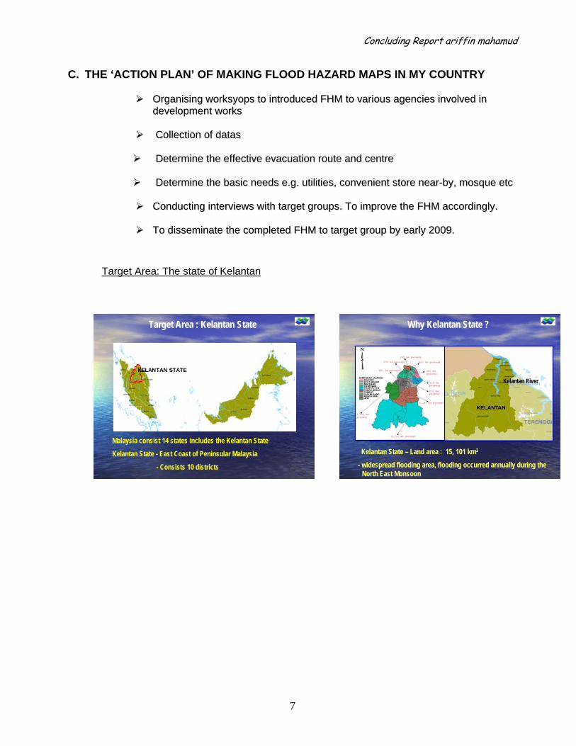
Target Area: The state of Kelantan
Target Area : Kelantan State
Malaysia consist 14 states includes the Kelantan State
Kelantan State - East Coast of Peninsular Malaysia
- Consists 10 districts
KELANTAN STATE
Kelantan State – Land area : 15, 101 km2
- widespread flooding area, flooding occurred annually during the North East Monsoon
Kelantan RiverKelantan River
Why Kelantan State ?

Concluding Report ariffin mahamud
8
Flood impact to the Kelantan State (1983 – 2004)
Usefulness of Flood Hazard Map in Kelantan State, Malaysia • To reduce property loss and casualties • To help a smooth evacuation • To give the awareness to residents the importance of FHM which lead to safe evacuation, thus lives and properties are safe • The state of Kelantan has many telemetric stations (water level and rainfall)
2004 10,476 12 14,317,800.00 3,767,842
2003 2,228 2 5,554,400.00 1,461,684
2002 no record no record 1,420,000.00 373,684
2001 5,800 0 8,462,700.00 2,227,026
2000 506 0 4,940,620.00 1,300,163
1999 no record 1 1,924,440.00 506,432
1998 136 0 1,628,455.00 428,541
1997 no record no record 922,020.00 242,637
1996 no evacuation 0 735,795.00 193,630
1995 1,172 4 1,485,095.00 390,814
1994 441 2 2,413,922.30 635,243
1993 13,587 0 1,512,816.50 398,110
1992 743 0 329,256.05 86,646
1991 no record 2 1,427,872.45 375,756
1990 4,581 4 1,036,100.00 272,658
1989 no record no record - -
1988 41,059 0 - -
1987 402 0 3,338,589.00 878,576
1986 7,968 0 6,092,454.25 1,603,277
1985 no record no record - -
1984 7,177 9 1,998,268.00 525,860
1983 33,815 0 -
Total amount of damages (in USD)Year Total of
Evacueess
Total of Death People
Total amount of damages (in Ringgit
Malaysia)
Concluding Report ariffin mahamud
9
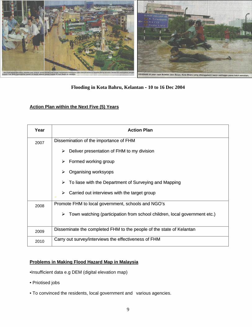
Flooding in Kota Bahru, Kelantan - 10 to 16 Dec 2004
Action Plan within the Next Five (5) Years
Year Action Plan
2007 DDiisssseemmiinnaattiioonn ooff tthhee iimmppoorrttaannccee ooff FFHHMM
DDeelliivveerr pprreesseennttaattiioonn ooff FFHHMM ttoo mmyy ddiivviissiioonn
FFoorrmmeedd wwoorrkkiinngg ggrroouupp
OOrrggaanniissiinngg wwoorrkkssyyooppss
TToo lliiaassee wwiitthh tthhee DDeeppaarrttmmeenntt ooff SSuurrvveeyyiinngg aanndd MMaappppiinngg
CCaarrrriieedd oouutt iinntteerrvviieewwss wwiitthh tthhee ttaarrggeett ggrroouupp
2008 PPrroommoottee FFHHMM ttoo llooccaall ggoovveerrnnmmeenntt,, sscchhoooollss aanndd NNGGOO’’ss
TToowwnn wwaattcchhiinngg ((ppaarrttiicciippaattiioonn ffrroomm sscchhooooll cchhiillddrreenn,, llooccaall ggoovveerrnnmmeenntt eettcc..))
2009 DDiisssseemmiinnaattee tthhee ccoommpplleetteedd FFHHMM ttoo tthhee ppeeooppllee ooff tthhee ssttaattee ooff KKeellaannttaann
2010 CCaarrrryy oouutt ssuurrvveeyy//iinntteerrvviieewwss tthhee eeffffeeccttiivveenneessss ooff FFHHMM
Problems in Making Flood Hazard Map in Malaysia
•Insufficient data e.g DEM (digital elevation map) • Priotised jobs • To convinced the residents, local government and various agencies.
Concluding Report ariffin mahamud
10
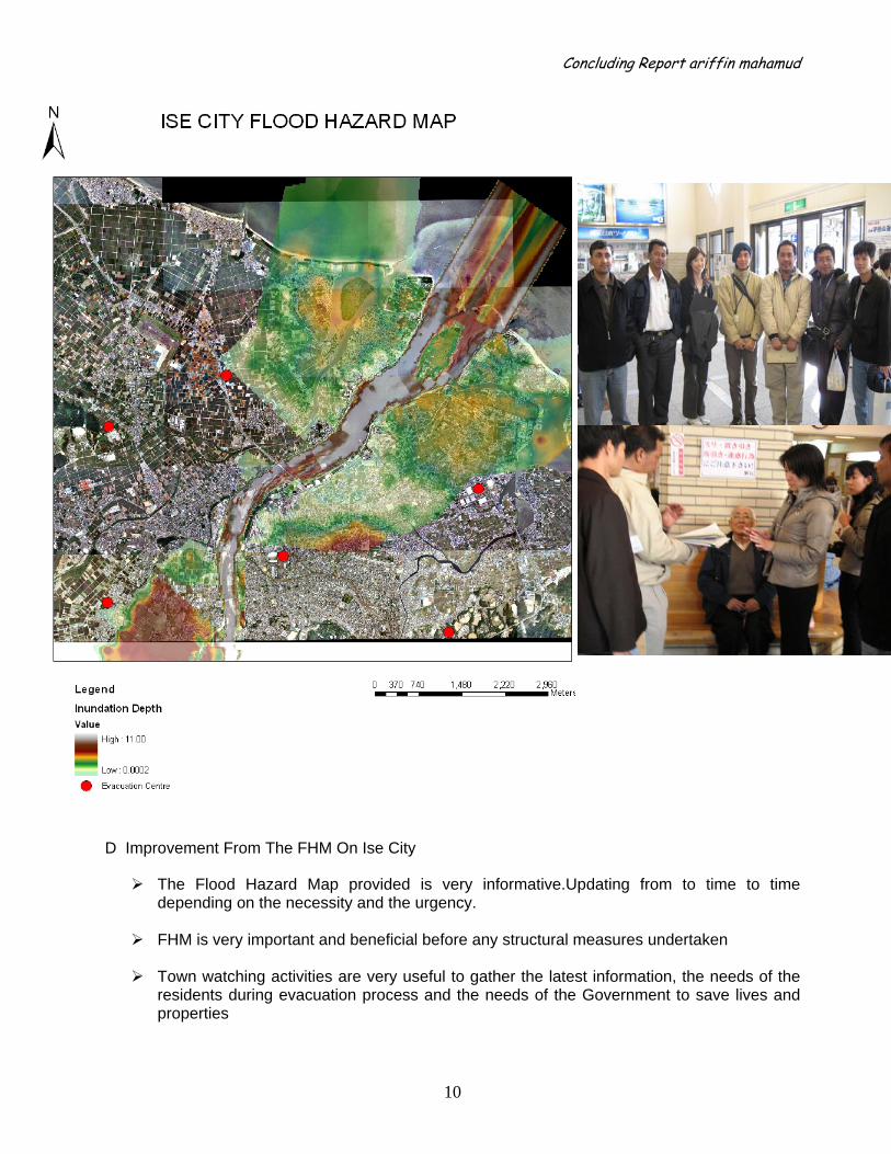
D. My own Flood Hazard Map on Ise City.
E. ADVICE/SUGGESTIONS IN MAKING THIS GFUL
‘
D Improvement From The FHM On Ise City
The Flood Hazard Map provided is very informative.Updating from to time to time depending on the necessity and the urgency.
FHM is very important and beneficial before any structural measures undertaken
Town watching activities are very useful to gather the latest information, the needs of the
residents during evacuation process and the needs of the Government to save lives and properties
Concluding Report ariffin mahamud
11
The cooperation between residents, Municipal Office and the Government will save a lot of lives and property loss.
FHM is very importantant for town planners to develop any city to cope up with hazards
E Conclusion
• Knowledged and technical know-how acquired in Japan is a treasure, hence very
beneficial to me and my department • ICHARM/PWRI/JICA had successfully delivered the needs of the developing countries to
safe lives and properties - for the sake of mankind through this FHM course F Acknowledgement I would like to take this opportunity to thanks ICHARM / PWRI / JICA for making this course a successful, enjoyable and a memorable event. My deepest appreciation to all the staffs for their hardworking and understandings to bear with 16 participants of different personalities and character. It’s really a good experience to be with you all and my dear participants. My sincere gratitude and appreciation to TBIC for making my stay in Japan so enjoyable though sometimes ‘homesick’. Domo arigato gozaimasu. See you