Embed Size (px)
Citation preview
19
Unit
3
Activities
1. WhatistheweatherlikeintheBritishIsles?
�In�pairs,�ask�questions�and�answer�about�each�city�shown�in�the�map.
What is the weather like in Manchester?
It’s partly cloudy.
2. Writeadefinitionforeachofthefollowing:
1.�season�–� �� �
2.�climate�–�. �� �
3.�meteorologist�–� �� �
3. MarkTwainsaid:“Climateiswhatyouexpect,weatheriswhatyouget.”
Explain�the�meaning�of�this�sentence�in�your�own�words.
Weather and ClimateWhat is weather?
CitiesWhatwillthe
weatherbeliketomorrow?
Highesttemperature
Lowesttemperature Humidity
Paris,�France
London,�UK
Madrid,�Spain
Cairo,�Egypt
Moscow,�Russia
New�Delhi,�India
Beijing,�China
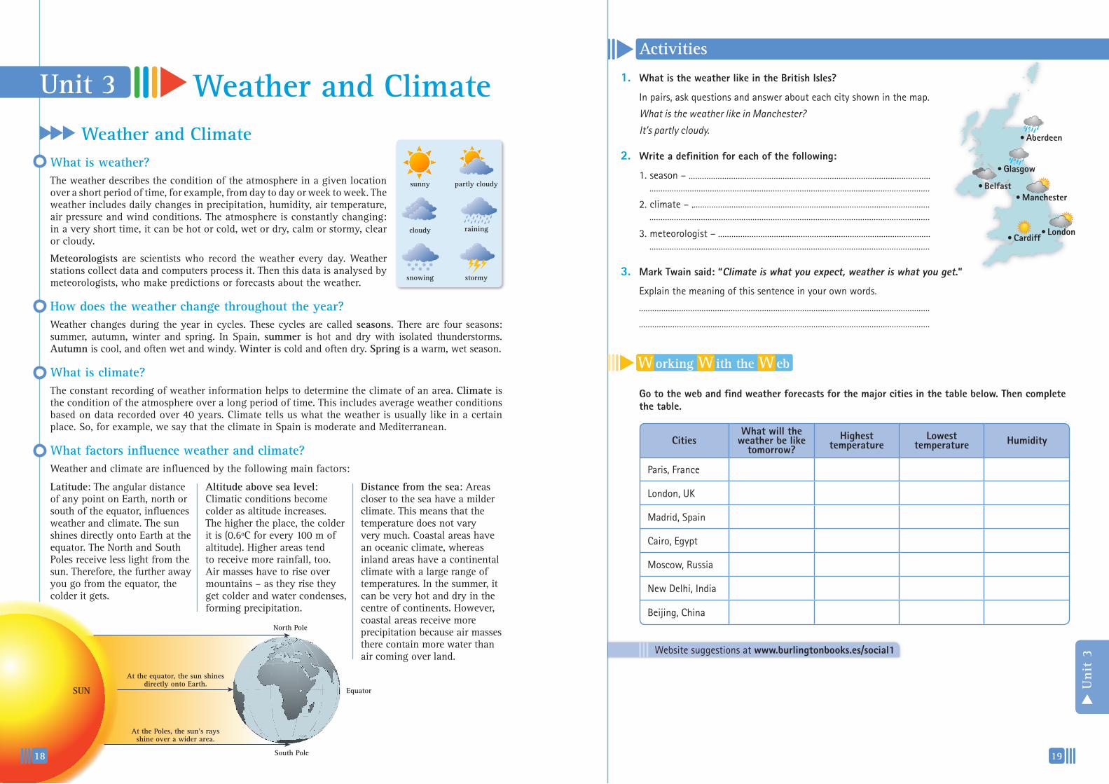
•Aberdeen
•Belfast•Manchester
•London•Cardiff
W orking W ith the W eb
Gotothewebandfindweatherforecastsforthemajorcitiesinthetablebelow.Thencompletethetable.
Weather and ClimateUnit 3
How does the weather change throughout the year?Weather changes during the year in cycles. These cycles are called seasons. There are four seasons: summer, autumn, winter and spring. In Spain, summer is hot and dry with isolated thunderstorms. Autumn is cool, and often wet and windy. Winter is cold and often dry. Spring is a warm, wet season.
What is climate? The constant recording of weather information helps to determine the climate of an area. Climate is the condition of the atmosphere over a long period of time. This includes average weather conditions based on data recorded over 40 years. Climate tells us what the weather is usually like in a certain place. So, for example, we say that the climate in Spain is moderate and Mediterranean.
What factors influence weather and climate?Weather and climate are influenced by the following main factors:
The weather describes the condition of the atmosphere in a given location over a short period of time, for example, from day to day or week to week. The weather includes daily changes in precipitation, humidity, air temperature, air pressure and wind conditions. The atmosphere is constantly changing: in a very short time, it can be hot or cold, wet or dry, calm or stormy, clear or cloudy.
Meteorologists are scientists who record the weather every day. Weather stations collect data and computers process it. Then this data is analysed by meteorologists, who make predictions or forecasts about the weather.
Distance from the sea: Areas closer to the sea have a milder climate. This means that the temperature does not vary very much. Coastal areas have an oceanic climate, whereas inland areas have a continental climate with a large range of temperatures. In the summer, it can be very hot and dry in the centre of continents. However, coastal areas receive more precipitation because air masses there contain more water than air coming over land.
Altitude above sea level: Climatic conditions become colder as altitude increases. The higher the place, the colder it is (0.6ºC for every 100 m of altitude). Higher areas tend to receive more rainfall, too. Air masses have to rise over mountains – as they rise they get colder and water condenses, forming precipitation.
North Pole
South Pole
At the equator, the sun shines directly onto Earth.
At the Poles, the sun’s rays shine over a wider area.
SUN
Latitude: The angular distance of any point on Earth, north or south of the equator, influences weather and climate. The sun shines directly onto Earth at the equator. The North and South Poles receive less light from the sun. Therefore, the further away you go from the equator, the colder it gets.
sunny
cloudy
snowing stormy
raining
partly cloudy
•Glasgow
Equator
18
Website�suggestions�at�www.burlingtonbooks.es/social1
1 2 3
4 5 6
20
Activities Elements of Weather and ClimateWhat are the different weather elements?
2. Tick(3)thesentencesT(true)orF(false).Thencorrectthefalsesentences.
1.�Air�pressure�is�also�called�atmospheric�pressure.� ��
2.�Water�vapour�condenses�to�form�clouds.� � ��
3.��Low�pressure�areas�form�when�the�air�mass�gets�warmer.� �
4.�Snow�and�rain�have�a�similar�origin.� � ��
5.��When�relative�humidity�is�high,�wet�clothes�dry�quickly.� �
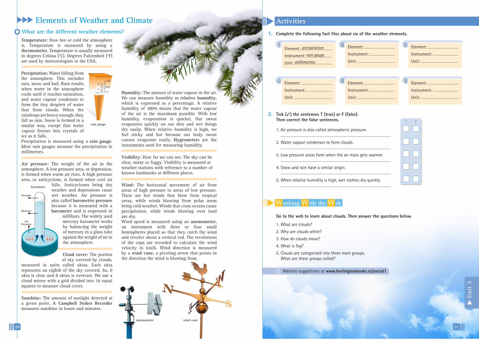
1. Completethefollowingfactfilesaboutsixoftheweatherelements.Temperature: How hot or cold the atmosphere is. Temperature is measured by using a thermometer. Temperature is usually measured in degrees Celsius (°C). Degrees Fahrenheit (°F) are used by meteorologists in the USA.
Precipitation: Water falling from the atmosphere. This includes rain, snow and hail. Rain results when water in the atmosphere cools until it reaches saturation, and water vapour condenses to form the tiny droplets of water that form clouds. When the raindrops are heavy enough, they fall as rain. Snow is formed in a similar way, except that water vapour freezes into crystals of ice as it falls. Precipitation is measured using a rain gauge. Most rain gauges measure the precipitation in millimetres.
Air pressure: The weight of the air in the atmosphere. A low pressure area, or depression, is formed when warm air rises. A high pressure area, or anticyclone, is formed when cool air
falls. Anticyclones bring dry weather and depressions cause wet weather. Air pressure is also called barometric pressure because it is measured with a barometer and is expressed in
millibars. The widely used mercury barometer works by balancing the weight of mercury in a glass tube against the weight of air in the atmosphere.
Cloud cover: The portion of sky covered by clouds,
measured in units called oktas. Each okta represents an eighth of the sky covered. So, 0 okta is clear and 8 oktas is overcast. We use a cloud mirror with a grid divided into 16 equal squares to measure cloud cover.
Sunshine: The amount of sunlight detected at a given point. A Campbell Stokes Recorder measures sunshine in hours and minutes.
T F
Element:� �
Instrument:� �
Unit:�
Element:� �
Instrument:� �
Unit:�
Element:� �
Instrument:� �
Unit:�
Element:� �
Instrument:� �
Unit:�
Element:� �
Instrument:� �
Unit:�
Element:� �
Instrument:� �
Unit:�
rain gauge
anemometer wind vane
Humidity: The amount of water vapour in the air. We can measure humidity as relative humidity, which is expressed as a percentage. A relative humidity of 100% means that the water vapour of the air is the maximum possible. With low humidity, evaporation is quicker. Our sweat evaporates quickly on our skin and wet things dry easily. When relative humidity is high, we feel sticky and hot because our body sweat cannot evaporate easily. Hygrometers are the instruments used for measuring humidity.
Visibility: How far we can see. The sky can be clear, misty or foggy. Visibility is measured at weather stations with reference to a number of known landmarks at different places.
Wind: The horizontal movement of air from areas of high pressure to areas of low pressure. There are hot winds that blow from tropical areas, while winds blowing from polar areas bring cold weather. Winds that cross oceans cause precipitation, while winds blowing over land are dry. Wind speed is measured using an anemometer, an instrument with three or four small hemispheres placed so that they catch the wind and revolve about a vertical rod. The revolutions of the cups are recorded to calculate the wind velocity in km/h. Wind direction is measured by a wind vane, a pivoting arrow that points in the direction the wind is blowing from.
precipitation
rain gauge
millimetres
W orking W ith the W eb
Gotothewebtolearnaboutclouds.Thenanswerthequestionsbelow.
1.��What�are�clouds?
2.��Why�are�clouds�white?
3.��How�do�clouds�move?
4.�What�is�fog?
5.��Clouds�are�categorised�into�three�main�groups.��What�are�these�groups�called?
Air Pressure
Mercury
Vacuum
barometer
Unit
3
21
Website�suggestions�at�www.burlingtonbooks.es/social1
300
250
200
150
100
50
0
30
25
20
15
10
5
0J F M A M J J A S O N D
100
100
80
60
40
20
0
40
30
20
10
0J F M A M J J A S O N D
300
250
200
150
100
50
0
30
25
20
15
10
5
0J F M A M J J A S O N D
350
300
250
200
150
100
50
0
35
30
25
20
15
10
5
0J F M A M J J A S O N D
100
80
60
40
20
0
20
10
0
-10
-20
-30J F M A M J J A S O N D
350
300
250
200
150
100
50
0
35
25
15
-5
-15J F M A M J J A S O N D
350
300
250
200
150
100
50
0
35
30
25
20
15
10
5
0J F M A M J J A S O N D
350
300
250
200
150
100
50
0
35
30
25
20
15
10
5
0J F M A M J J A S O N D
350
300
250
200
150
100
50
0
35
30
25
20
15
10
5
0J F M A M J J A S O N D
22 23
Unit
3
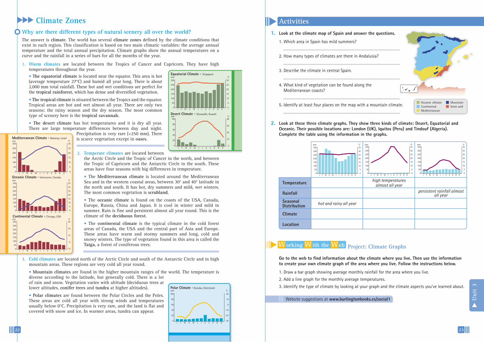
Activities Climate ZonesWhy are there different types of natural scenery all over the world? The answer is climate. The world has several climate zones defined by the climate conditions that exist in each region. This classification is based on two main climatic variables: the average annual temperature and the total annual precipitation. Climate graphs show the annual temperatures on a curve and the rainfall in a series of bars for all the months of the year.
W orking W ith the W eb Project: Climate Graphs
Gotothewebtofindinformationabouttheclimatewhereyoulive.Thenusetheinformationtocreateyourownclimategraphoftheareawhereyoulive.Followtheinstructionsbelow.
1.��Draw�a�bar�graph�showing�average�monthly�rainfall�for�the�area�where�you�live.
2.��Add�a�line�graph�for�the�monthly�average�temperatures.
3.��Identify�the�type�of�climate�by�looking�at�your�graph�and�the�climate�aspects�you’ve�learned�about.
3. Cold climates are located north of the Arctic Circle and south of the Antarctic Circle and in high mountain areas. These regions are very cold all year round.
• Mountain climates are found in the higher mountain ranges of the world. The temperature is diverse according to the latitude, but generally cold. There is a lot of rain and snow. Vegetation varies with altitude (deciduous trees at lower altitudes, conifer trees and tundra at higher altitudes).
• Polar climates are found between the Polar Circles and the Poles.These areas are cold all year with strong winds and temperatures usually below 0°C. Precipitation is very rare, and the land is flat and covered with snow and ice. In warmer areas, tundra can appear.
2. Temperate climates are located between the Arctic Circle and the Tropic of Cancer in the north, and between the Tropic of Capricorn and the Antarctic Circle in the south. These areas have four seasons with big differences in temperature.
• The Mediterranean climate is located around the Mediterranean Sea and in the western coastal areas, between 30° and 40° latitude in the north and south. It has hot, dry summers and mild, wet winters. The most common vegetation is scrubland.
• The oceanic climate is found on the coasts of the USA, Canada, Europe, Russia, China and Japan. It is cool in winter and mild in summer. Rain is fine and persistent almost all year round. This is the climate of the deciduous forest.
• The continental climate is the typical climate in the cold forest areas of Canada, the USA and the central part of Asia and Europe. These areas have warm and stormy summers and long, cold and snowy winters. The type of vegetation found in this area is called the Taiga, a forest of coniferous trees.
1. Warm climates are located between the Tropics of Cancer and Capricorn. They have high temperatures throughout the year.
• The equatorial climate is located near the equator. This area is hot (average temperature 27°C) and humid all year long. There is about 2,000 mm total rainfall. These hot and wet conditions are perfect for the tropical rainforest, which has dense and diversified vegetation.
• The tropical climate is situated between the Tropics and the equator. Tropical areas are hot and wet almost all year. There are only two seasons: the rainy season and the dry season. The most common type of scenery here is the tropical savannah.
• The desert climate has hot temperatures and it is dry all year. There are large temperature differences between day and night.
Precipitation is very rare (<250 mm). There is scarce vegetation except in oases.
EquatorialClimate•Singapore
DesertClimate•Shuwaikh,�Kuwait
MediterraneanClimate•�Natanya,�Israel
OceanicClimate•�Vancouver,�Canada
ContinentalClimate•�Chicago,�USA
PolarClimate•�Dundas,�Greenland
°Cmm
°Cmm
°Cmm
°Cmm
°Cmm
°Cmm
1. LookattheclimatemapofSpainandanswerthequestions.
1.�Which�area�in�Spain�has�mild�summers?
�
2.�How�many�types�of�climates�are�there�in�Andalusia?
�
3.�Describe�the�climate�in�central�Spain.
�
4.�What�kind�of�vegetation�can�be�found�along�the��� Mediterranean�coasts?
�
5.�Identify�at�least�four�places�on�the�map�with�a�mountain�climate.
�
2. Lookatthesethreeclimategraphs.Theyshowthreekindsofclimate:Desert,EquatorialandOceanic.Theirpossiblelocationsare:London(UK),Iquitos(Peru)andTindouf(Algeria).Completethetableusingtheinformationinthegraphs.
°Cmm °Cmm °Cmm
MountainSemi-arid
Oceanic climateContinentalMediterranean
Temperature high temperatures almost all year
Rainfall persistent rainfall almost all year
SeasonalDistribution hot and rainy all year
Climate
Location
Website�suggestions�at�www.burlingtonbooks.es/social1
Key Points
Progress Check
25
Unit
3
WeatherandClimate
Factors•Latitude��•Altitude�•Distance�from�the�sea
Types•Warm�climates:�
Equatorial,�Tropical�and�Desert•Temperate�climates:�
Mediterranean,�Oceanic��and�Continental
•Cold�climates:�Mountain�and�Polar
Choosethecorrectanswer.
1. Climateisdifferentfromweatherbecause….a.��it�concerns�average�weather�over�a�
period�of�time
b.�of�the�greenhouse�effect
c.� �it�concerns�only�short-term�weather�measurements
2. Latitudeaffectsclimatebecause….a.��the�closer�a�place�is�to�the�equator,�the�
colder�it�is
b.��the�equator�receives�more�sunlight�than�anywhere�else�on�Earth
c.� �the�sun’s�rays�are�perpendicular�to�the�Poles�
3. Altitudeaffectsclimatebecause….a.�temperature�increases�with�altitude
b.�the�water�vapour�cools�as�it�rises
c.� rainfall�decreases�with�altitude
4. Anticyclones….a.�are�areas�of�low�atmospheric�pressure
b.�bring�calm�and�sunny�weather
c.�are�winds�blowing�over�land�
5. Itrainsbecause….a.�clouds�move�from�east�to�west
b.��water�vapour�condenses�when�the�air�pressure�goes�down
c.� �water�vapour�in�clouds�forms�heavy�raindrops
6.� �Countrieswhichhaveatropicalclimatearelocated....a.�in�the�Mediterranean�region
b.�between�the�equator�and�the�Tropics
c.�at�the�North�and�South�Poles
7. Adesertclimateisfound….a.�at�the�equator
b.�in�the�Polar�regions
c.� in�the�Sahara
8. AMediterraneanclimatetypicallyhas….a.�cold�winters�and�hot�summers
b.�mild�winters�and�dry,�hot�summers
c.� �drought�conditions�throughout�the�year
9. Polarclimatesarecharacterisedby….a.��cold�temperatures�throughout�the�year
b.�hot�and�dry�conditions
c.� rain�and�fog�throughout�the�year
0. Anoceanicclimate….a.�is�located�near�the�coast
b.�has�extremes�of�weather
c.� is�hot�and�dry
11
InstrumentThermometerRain�gaugeBarometerAnemometerWind�vane�HygrometerCampbell�Stokes�RecorderCloud�mirrorLandmarks
UnitofMeasurementoC�/�oFmillimetresmillibarskm/h-expressed�as�a�percentage�hours�and�minutesoktas-
Element•Temperature•Precipitation•Air�pressure•Wind�speed•Wind�direction•Humidity•Sunshine•Cloud�cover•Visibility
24