Embed Size (px)
Citation preview

Alun Dolton MA Dip Arch ARB - Portfolio 2015
Architect Urban Designer Masterplanner

Meinhardt Group 2014 - 2015Team Leader, Lead Urban DesignerPreparation of Strategic Development Plan for urban development covering 450,000 hectares. Leading proposals and studies on projects for new cities.
Omrania and Associates 2011 - 2014Chief Architect/MasterplannerLeading concept design and design development on projects, working in collaboration with international client and design teams.
Saudi Arabia Parsons LimitedSenior Urban Designer2011 on Ministry of housing projects. 11 Projects ranging from 70ha to over 1000ha on sites across KSA. Working in conjunction with international team and government agencies.
Dar Al Riyadh 2010 - 2011.Lead Designer/MasterplannerMasterplanning, 65ha Al Rimal Desert Community, North Riyadh KSA.
Aedas 2002-2010.AssociateExtensive experience in masterplanning, concept design, undertaking feasibility studies and
with Client organization, stakeholders, local authorities and inter-professional teams.
R & D Group leader for Urban Design and
Birmingham at School of Architecture 2005-2008 (Part time whilst at Aedas)
Visiting Tutor 2007-2008Volunteer Critic 2005-2007
Beneath the Surface of Architecture 2001- Present: FounderReseach project investigating the link between architecture, society and the environment.

Introduction
When joining a practice, unless recruited for
guarantee what you are going to be working on.
territory, and part of a larger entity than just the project, and as an Architect involvement stretches to cover areas such as programme management, project management, masterplanning, public consultation, and assuming roles such as lead designer, team leader, focal point.
This is more than a collection of images from projects that I have been associated with it is more of a journey through my career to date using the projects as examples, with a narrative giving an insight into the experience of involvement in the project.
Over the past 14 years the major focus of my work has been on Masterplanning, where involvement in projects goes far beyond the skills related to knowing how buildings go together, and more about the big picture that the Architecture is part of. Collaborating with professionals on large multi-disciplinary teams becomes a major element of the time involved in bringing a project to fruition, along with managing a multitude of stakeholders that are essential to the success of a project.
Alongside working on projects is a preoccupation of mine, urban research, some of it is presented here as part of my involvement with Aedas R&D and some of the areas that continue to fascinate me.

Preliminary Study for Strategic Development Plan Area of 1198 square Kilometres, Pakistan 2015
Urban Planning
Planning a Smart City
Smart cities follow a hierarchical process:
PeoplePlaceTechnology
People
from educating people about consuming less energy, about how what they are doing impacts on the global situation, to fostering research into sustainable design, sustainable agriculture, sustainable water usage, sustainable transport, advances in biology, chemistry and technology.
Place
The second component is place, it is about building on the identity of Gwadar, the existing city, the landscape and its strategic location on the world stage, it is likely that this will yield competing priorities, for example how do we connect Gwadar Port to the required infrastructure without destroying the existing Gwadar City, how we create engines of economic growth without adversely affecting the environment, particularly when one of the key drivers is heavy industry.
Technology
The third component is the technology, which is not all about smart phones, electronic devices and communications technology. It starts with sustainable planning around the appropriate infrastructure, public transport, freight transportation, logistics, power, water, and the handling of waste products. The advantages of planning holistically mean that travel distances are reduced, energy consumption is reduced along with the emission of harmful greenhouse gases into the atmosphere.
Sustainable Urban planning
The key to sustainable planning is compact mixed use developments that are based around infrastructure nodes, meaning that it is possible to live and work in the same place, with access to leisure amenities, public facilities where from a human point of view means easy access to safe and comfortable public transport, so that the reliance on private vehicles is reduced and in some cases eliminated.
Meinhardt Group
Location: Gwadar, Balochistan
Area: 1198,000 Hectares330,000 Acres
Role: Team leader

Eastern Gateway - Innovation City Airport City Logistics City
Central Business District Education City Medical City
Government and Financial Western Gateway Overview

Strategic Development Plan covering 450 square Kilometres: Pakistan 2014-2015
Meinhardt Group
Area: 450,000 Hectares/111,000 AcresPopulation: 15 Million
Key Challenges:
Growing populationFlooding. Degradation and pollution of the River.CongestionExisting Settlements, Industry and AgricultureSuburban Sprawl and unreliable energy supplyDegradation of natural environment
Key Objectives
Treating the city’s waster water
Developng robust ingregrated transport networkDeveloping robust and reliable infrastructureImproved quality of lifeMitigate impact on agricultureRestore natural environment
Creating a Sustainable City
Successfully incorporating sustainable urban planning and development into how the city operates is an essential part of the global response to climate change and to improving energy security. The greatest environmental gains can be achieved through strategies that have no increment cost, such as planning compact urban centers, integrated public transport, treating urban development holistically so that the blocks are planned so as to orientate the
gain on external walls and maximize cool breezes. Narrow streets that increase shading and reduce building cooling loads and avoid the creation of heat islands are another.
The planning of the project follows a compact city approach to be able to minimize its environmental impact.
The strategy on the project is to form communities, where close proximity to neighborhood amenities, commercial areas, and parks means that it is possible to walk from the house to the shops and school, interact with the community through a network of pedestrian footpaths and cycle ways. Integrated strategies of urban farming uses part of the park areas are used to grow fruit, vegetables and grains to contribute to the overall demand for food. Based around community clusters and neighborhoods, the residential strategy creates spaces which allow neighbors to know one another and reinforce family bonds. By integrating community and commercial
Urban Planning

The project sets targets that may sound ambitious but are achievable using existing technology and current expertise regarding smart design and holistic planning:
50% reduction in Water Use70% reduction in cooling load50% power from renewables
New parks and green space network totaling 1000 hectares/2500 Acres creating space to plant over 130,000 trees that will absorb 9,600 tons of CO2 from the atmosphere every year.
Reforestation area of 1185 Hectares/2900 Acres,
over 10,000 tons of C02 per year.
activity a vibrant connected private and public life will create high a quality living experience. The use of the riverfront and water channels creates waterfront communities each with a unique character.
Mixed use development is a core component of sustainable urban design to combat issues associated with sprawl. The placement of living and working within the same zone or even the same block,
infrastructure and provide pedestrian friendly areas where living, working and leisure activities occur simultaneously to prevent the formation of ghettos where all activity dies off after 6pm. This is achieved
uses include retail, light industry including assembly
beverage outlets, community facilities.
Eco City principles are applied throughout the project through introducing penetrable green strips through the urban area to form a main spine of the city that acts as Ecological corridors that will connect the waterfront promenade with the green belt which will reconnect the River with the urban experience. The project will retain and over time restore most of the existing forests and orchards and in the urban parks, edible forests will augment the existing orchards, through compensating for the loss through additional planting. The structure of the City follows the north
boundaries and will stimulate urban renewal and development in a sustainable and cohesive manner.
The master plan creates the opportunity for sustainable and controlled growth along the Riverfront by creating
local, regional and national need, Health, Education, Innovation, Business, Financial, Government each with localised energy centres focussing on the integration of renewable sources.
The cities are unifed by a continuous, publicly accessible waterfront that provides connectivity between the vitality of the existing city and the vitality of the new unique cities that have their identity based in the rich culture of the region. A sustainable, ecologically productive urban experience heralding a new era for Pakistan and an exemplar the world in terms of a holistically designed city on such a vast scale.

Strategic Development Plan for Swabi and Nowshera District, Pakistan 2014 - 2015
Meinhardt Group
Location: Swabi and Nowshera District, PakistanClient: Provincial Housing Authority KPK Area: 48,000 Hectares/1xxxxAcresPopulation: 4.5 Million
Objective
The project is part of social, economical and education development plan of KPK government. The project’s aim is a mixed use development that will deliver housing society requirements along with education facilities capable of accommodating approximately 20 national/international campuses to the door step of rural community of KPK province.
The need for the project
The Education City Development, spearheaded by the Chief Minister of KPK, is a prestigious, strategic project of national and international importance. The proposed Project will utilize the allocated less productive agriculture land into an Education city. The project shall deliver the economic and social development to KPK especially to Swabi & Nowshera districts.
Making the Urban area of the Khyber Pakhtoonkhwah province sustainable, livable and well-managed engines of economic growth.
The project comprises the following components:
University DistrictRetail DistrictBusiness DistrictCommercial HubLeisure and Tourism DistrictEco ParksResidential Districts with individual commercial centres
Urban Planning

The city is remote from any neighbouring settlements, and to a degree is relient on creating its own identity and sense of place. The formation of the project into districts of high density development, low density and open space networks allows for different character areas and variety of urban experience to build
whole.

The site is located south of Thuwal, north of Jeddah and falls outside the development boundaries of both municipalities, On a site large enough to accommodate New York’s Central park with 3 avenues either side and 4 streets ate either end, the aim is to develop a new urban centre that will serve as a nucleus to future developments.
Located alongside the new Haramain high speed rail
basin that deals with rainwater runoff from the nearby mountain range, the plan from the municipality is to provide more suburban development that is prevalent across Saudi Arabia.
The concept is based on planning the site through the formation of 10 Mujaweras located around a central park. Each Mujawera centre comprises the Friday Mosque as its central focal point along with local educational and commercial facilities to serve each community; the disposition of which is based on walkable distances at a maximum of 800m.
Each centre is linked through a network of green corridors forming walkable routes between all areas.
park space that forms a green spine linking all of the communities together.
node, whilst the centre forms the location of a town square that accommodates religious, cultural and commercial activities throughout the year ranging from Eid prayer, to weekly markets, to daily visits torestaurants and coffee shops. The park also forms the location for the high schools, allowing opportunities to accommodate the use of sports facilities by the community outside of school hours.
Hijra - Ministry of Housing, Thuwal KSA. 2014
The perimeter of the park is bounded by a loop road which links the communities together, whilst providing direct links to the site perimeter. Mixed use development is concentrated on the outer edge of the link road, comprising varied ground
well as affording commercial opportunities, with apartments above to create an integrated urban living environment.
The green network is linked to the wadi running along
control system, and creates a buffer zone to the site edge.
Masterplanning

Access Vehicular Circulation
Catchment Areas: Commercial Catchment Areas: Cultural Catchment Areas: Educational
Green Space Network
Masterplan
Development Sketch

Salboukh Expatriate Compound Riyadh - 2013
Omrania
Expatriate Compound in a ‘Mediterranean Resort’ setting on a 65ha site located on the Salboukh Road North Riyadh comprising:
151 Villas, 70 Duplexes and 12 Apartment blocksTotalling 525 Residential Units.
Detailed masterplanning of site from initial concept to comply with MOI requirements for security, Civil Defence requirements for emergency access and Municipality regulations for car parking and massing.
Development site wide strategies for deliveries and solid waste management.
Project Team:
Omrania:
MasterplanningArchitectureInterior DesignProject ManagementCivil and StructuralMechanical, Electrical, Public health.
EDSALandscape
SGWSecurity
Client: Gulf Related
Masterplanning
Coordination with intrastructure and landscape to develop water management strategy that minimises wastage. Detailed 3d modelling of terrain to validate
Detailed planning and value engineering of the Community Facilities, including short stay apartments, clubhouse, resort pool, retail outlets, food and beverage, back of house facilities, administrative
Utilities compound including staff accommodation, security suite, water treatment plant, sewage treatment plant and solid waste transfer station.
From Ad Dir’iyah
To Salboukh
From
Airport
Al Jorah
North Riyadh Hospital
Project Site KING
KHALID
RO
AD
KING SALMAN ROAD
NORTH
RIYADH
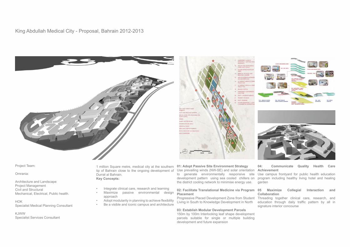
King Abdullah Medical City - Proposal, Bahrain 2012-2013
Project Team:
Omrania:
Architecture and LandscapeProject ManagementCivil and StructuralMechanical, Electrical, Public health.
HOKSpecialist Medical Planning Consultant
KJWW Specialist Services Consultant
1 million Square metre, medical city at the southern tip of Bahrain close to the ongoing development of Durrat al Bahrain. Key Concepts:
Integrate clinical care, research and learningMaximize passive environmental design approach
Be a visible and iconic campus and architecture
01: Adopt Passive Site Environment Strategy Use prevailing winds (NW-SE) and solar orientation to generate environmentally responsive site development pattern using sea cooled chillers on the district cooling network to minimise energy use.
02: Facilitate Translational Medicine via Program PlacementProgressive Placed Development Zone from Student Living in South to Knowledge Development in North
03: Establish Modular Development Parcels150m by 100m Interlocking leaf shape development parcels suitable for single or multiple building development and future expansion
04: Communicate Quality Health Care AchievementUse campus frontyard for public health education program including healthy living hotel and healing garden
05 Maximize Collegial Interaction and CollaborationThreading together clinical care, research, and
signature interior concourse
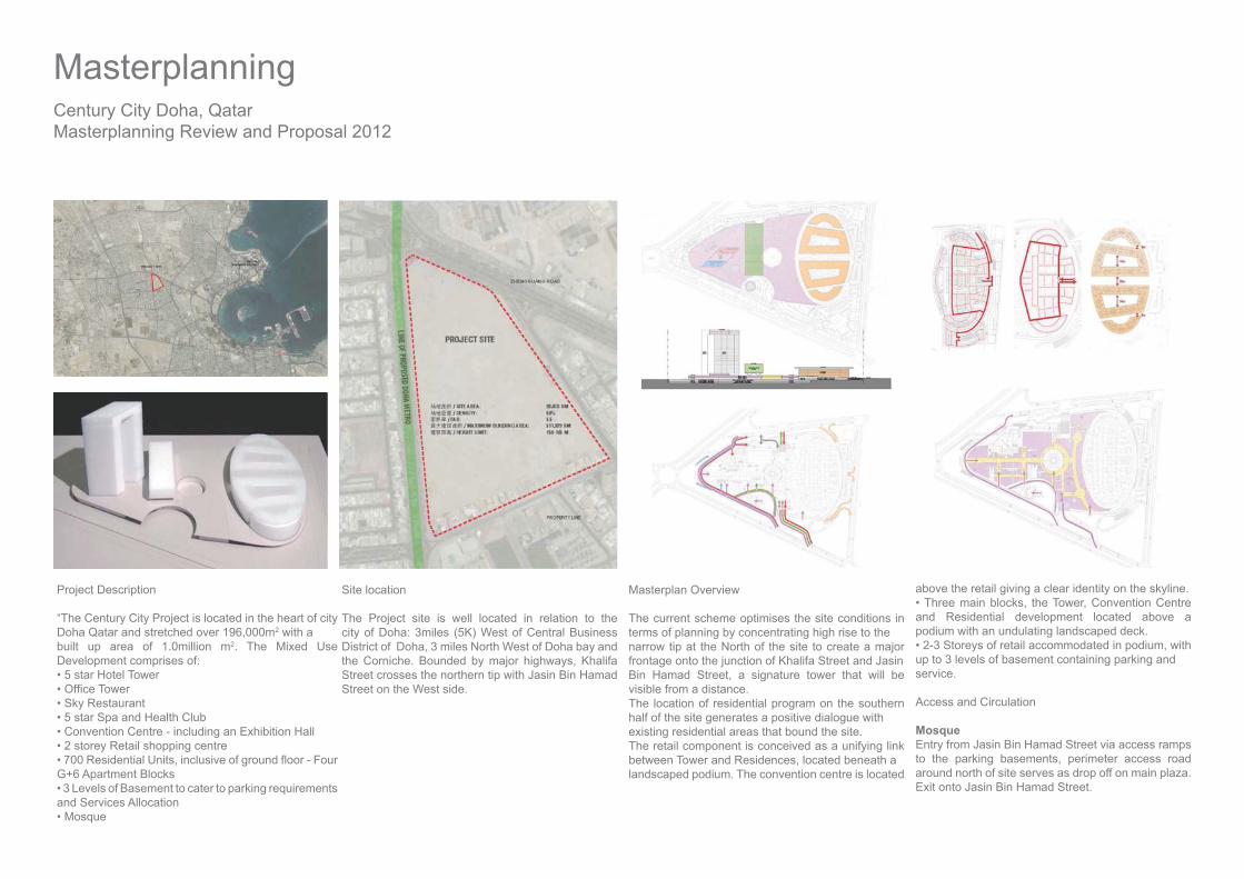
Century City Doha, Qatar Masterplanning Review and Proposal 2012
Project Description
“The Century City Project is located in the heart of city Doha Qatar and stretched over 196,000m2 with abuilt up area of 1.0million m2. The Mixed Use Development comprises of:
G+6 Apartment Blocks
and Services Allocation
Site location
The Project site is well located in relation to the city of Doha: 3miles (5K) West of Central Business District of Doha, 3 miles North West of Doha bay and the Corniche. Bounded by major highways, Khalifa Street crosses the northern tip with Jasin Bin Hamad Street on the West side.
Masterplan Overview
The current scheme optimises the site conditions in terms of planning by concentrating high rise to thenarrow tip at the North of the site to create a major frontage onto the junction of Khalifa Street and JasinBin Hamad Street, a signature tower that will be visible from a distance.The location of residential program on the southern half of the site generates a positive dialogue withexisting residential areas that bound the site.The retail component is conceived as a unifying link between Tower and Residences, located beneath alandscaped podium. The convention centre is located
above the retail giving a clear identity on the skyline.
and Residential development located above a podium with an undulating landscaped deck.
up to 3 levels of basement containing parking andservice.
Access and Circulation
MosqueEntry from Jasin Bin Hamad Street via access ramps to the parking basements, perimeter access road around north of site serves as drop off on main plaza. Exit onto Jasin Bin Hamad Street.
Masterplanning

Project Team:
Omrania:
MasterplanningArchitecture and LandscapeProject ManagementCivil and StructuralMechanical, Electrical, Public health.
Goettsch PartnersSpecialist Retail Consultant
KJWW Specialist Services Consultant
Retail MallEntry/Exit from Yenbu Street (East Side) and Jasin Bin Hamad Street (West Side) via access ramps to the parking basements. Perimeter access road around North of site serves as drop off on main plaza with exit onto Jasin Bin Hamad Street.
Conference CentreEntry from Jasin Bin Hamad Street via access ramps to the parking basements, perimeter access road around North of the site serves as drop off on main plaza. Exit onto Yenbu Street.
Perimeter access road around North of site serves as drop off and access to parking basement, exit ontosame and onto Yenbu Street.
HotelPerimeter access road around North of site serves as drop off and access to parking basement, exit ontosame and onto Yenbu Street. Access to parking basement from Yenbu Street, exit onto Jasin Bin Hamad Street
ResidentialEntry/Exit on Yenbu Street, Al Wabra Street (Southern Perimeter of site).
zone.
property line, note that there is a setback fromhighway edge suggesting that the scheme respects an easement.
The shade from buildings, penetrations through podium and planting to reduce heat island effect.

Masterplanning
Saudi Arabia Parsons Limited
500,000 new homes will be built across the Kingdom of Saudi Arabia. Under secondment to Saudi Arabia Parsons Limited, Development of model for a compact sustainable community that was part of the winning bid.
The intention was to create a set of core principles that could be applied across 11 sites across the Kingdom of Saudi Arabia
The Charette Process
The project was launched with a charrette, an intense collaborative process where a team of 50+ professionals from US, UAE and KSA including: urban designers, town planners, specialist neighbourhood planners, architects, landscape architects, infrastructure engineers, highway engineers, illustrators were working alongside representatives from the Ministry of Housing. Developing schemes that were constantly developing as more data became available, along with feedback from Ministers during the charette process.
Ministry of Housing: KSA Wide 2011
Project Objectives
Generate desirable homes for Saudi familiesCreate integrated & sustainable communitiesSafe and convenient pedestrian & vehicular access Promote healthy lifestyles Respect individual privacy Merge the best of the past with state of the art technology Ensure cost effectiveness & constructability
Damman - 27154 Units: 984 Ha
Al Qateef Aramco : 4852 Units: 209 Ha
Al Qateef Badrani : 3854 Units: 152 Ha
El Eshaa : 3452 Units: 193 Ha
Buffer Zone Section
Part Section through frontage and courtyardDamman Demonstration Model
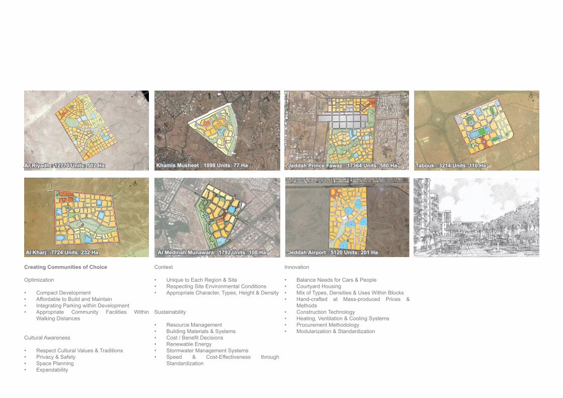
Creating Communities of Choice
Optimization
Compact DevelopmentAffordable to Build and MaintainIntegrating Parking within DevelopmentAppropriate Community Facilities Within Walking Distances
Cultural Awareness
Respect Cultural Values & TraditionsPrivacy & SafetySpace PlanningExpandability
Context
Unique to Each Region & SiteRespecting Site Environmental ConditionsAppropriate Character, Types, Height & Density
Sustainability
Resource ManagementBuilding Materials & Systems
Renewable EnergyStormwater Management SystemsSpeed & Cost-Effectiveness through Standardization
Innovation
Balance Needs for Cars & PeopleCourtyard HousingMix of Types, Densities & Uses Within BlocksHand-crafted at Mass-produced Prices & MethodsConstruction TechnologyHeating, Ventilation & Cooling SystemsProcurement MethodologyModularization & Standardization
Ar Riyadh : 12770 Units: 502 Ha
Al Kharj : 7724 Units: 232 Ha
Khamis Musheet : 1098 Units: 77 Ha
Al Medinah Munawara : 1792 Units: 108 Ha
Jeddah Prince Fawaz : 17364 Units: 580 Ha
Jeddah Airport : 5120 Units: 201 Ha
Tabouk : 3214 Units: 110 Ha
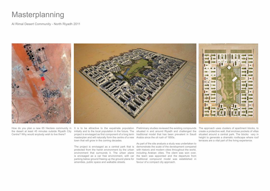
How do you plan a new 65 Hectare community in the desert at least 45 minutes outside Riyadh City Centre? Why would anybody wish to live there?
It is to be attractive to the expatriate population initially and to the local population in the future. The
masterplan and will naturally form the centre of a new town that will grow in the coming decades.
The project is envisaged as a central park that is protected from the harsh environment by the urban environment that surrounds it. The urban plane is envisaged as a car free environment, with car parking below ground freeing up the ground plane for amenities, public space and walkable streets.
Preliminary studies reviewed the existing compounds situated in and around Riyadh and challenged the traditional model that has been prevalent in Saudi Arabia since the oil rush of 1950s.
As part of the site analysis a study was undertaken to demonstrate the scale of the development compared with historic and modern cities throughout the world, including Arabian cities. The client was won over, the team was appointed and the departure from traditional compound model was established in favour of a compact city approach.
Al Rimal Desert Community - North Riyadh 2011
Masterplanning
The approach uses clusters of apartment blocks, to create a protective wall, that enclose pockets of villas situated around a central park. The blocks vary in height to generate a dramatic roofscape where roof terraces are a vital part of the living experience.

Compact city approach
Drawing from traditional approaches to the Arabian city before the advent of cars and air conditioning, taking examples from historic Riyadh along with contemporary interpretations at the National Musem and the Diplomatic Quarter.
Dealing with cars
The use of basements for car parking means that cars are stored in a cool environment, space is freed up on the surface for amenities and blocks can be placed closer together to maximise shading and create cooler external environment.
Walkable Streets
The placement of cars below grade permits the urban
a car free environment, narrow shaded walkways create routes where it is possible to walk even during the height of summer. The walkways are lined with cafes, shops and residential amenities.
Variety of Experience
The courtyards of the blocks comprise varied amenities ranging from formal gardens, swimming pools, sports courts to resort pool areas creating a beach-like environment, clusters of blocks contain different amenities giving each cluster it own identity.

Security Forces Hospital - Dar Al Riyadh
Masterplan for upgrade existing hospital:
Vehicular and pedestrian circulation strategy.Formation of new entry plaza with mosque as focal point. Introduction of parking structures to free up site area for upgrade of facilities.
Security Forces Hospital, Riyadh KSA - 2011
Masterplanning
Feasibility study for introduction of raised covered
Development of landscape strategy for whole site.
Extensions and alterations to existing facilities.
Development of new 12 storey ward block,

RAF Brize Norton: Project SLAM UK - 2003-2010
Aedas: 7 years of my life.
Working within an Establishment wide Masterplan and part of a national initiative to consolidate military assets.
Initial phases centred on developing a strategy for
of service personnel living on the Establishment. From testing the feasibility of developing a combined
Ranks living zones working within existing campus and operational constraints.
The masterplanning process for Living zones alone prompted a revision to the project brief which comprised changes to national programme, delivery strategy and funding streams which required buy in from the topmost level.
The Sergeants’ Campus was delivered in 2005, with
2008.
Junior Ranks Campus was developed in conjunction with Station command, strategic programmes and operational protocols including negotiating the decomissioning and replacement of a radar tower on the UK’s busiest active airbase.
Extensive Negotiations with Local Authorities to secure planning consent involved the development of strategic frameworks for station-wide sustainability,
drainage (SUDS) and foul drainage management strategies.
Junior Ranks Accommodation Phases 1 & 2 commenced in 2010 along with extensive enabling works to facilitate delivery of phases 3 & 4. Delivery anticipated 2012 all using off site fabrication to maintain continuity.
Project Team:
Defence EstatesDebut Services LimitedAedas - Architecture, LandscapeScott Wilson - Civil and Structural, Scott Wilson - Environmental ConsultantHulley and Kirkwood - M&ECaledonian Building Systems - Module FabricatorInterserve. Prime ContractorEntec - Establishment Wide Masterplan
Role Lead Designer, Masterplanner.

MasterplanningTraining Establishment UK 2006 - 2007.
Aedas - 2 years of my life.
Development of masterplan for Establishment comprising training, technical, administrative, living and recreational facilities on medical training campus for Army, Navy, Air force personnel. A project of National Strategic importance following Lyons Review, to relocate assets from South East, and was subject to Ministerial Approval
The masterplan included Environmental Impact Assessment, retention of historic assets along with feasibility studies for reuse of existing assets.
During the process the masterplan was used to
solution to be achieved.
Sustainibility: application of DREAM (Defence Related Energy Assessment Methodology) process to allow military facilites to be assessed realistically, led to development of site wide energy strategy along with national renewables initiatives.
A large component of the masterplan dealt with the logististics of two prime contractors working side by side on the same site leading to some interesting phasing strategies.
Status: Enabling works undertaken 2010 Project SLAM on site 2012.
Client: Secretary of State for Defence
Project Team:
Defence EstatesDebut Services LimitedAedas - Architecture, LandscapeArup - StructuralRybka - M&ECarillion RPC CentralTPS - Architecture, Landscape, EngineeringHalcrow - Environmental Impact AssesmentCSJ Brooke Smith - Planning
Stakeholders:
CFT (Army, Navy, Airforce)
Staffordshire County Council
Role lead designer for SLAM

Aedas
Upgrade of existing facilities for National Policing Improvement Agency, including Conference Centre and Operations Building along with Residential Accommodation.
NPIA Masterplan Ryton UK - 2008 Sandwell 2010/Grove Lane Masterplan, UK - 2005
Aedas
Urban regeneration scheme centred around 90,000m2 Hospital on a 6.5ha site to reprovide facilities currently provided at City Hospital and Sandwell Hospital.
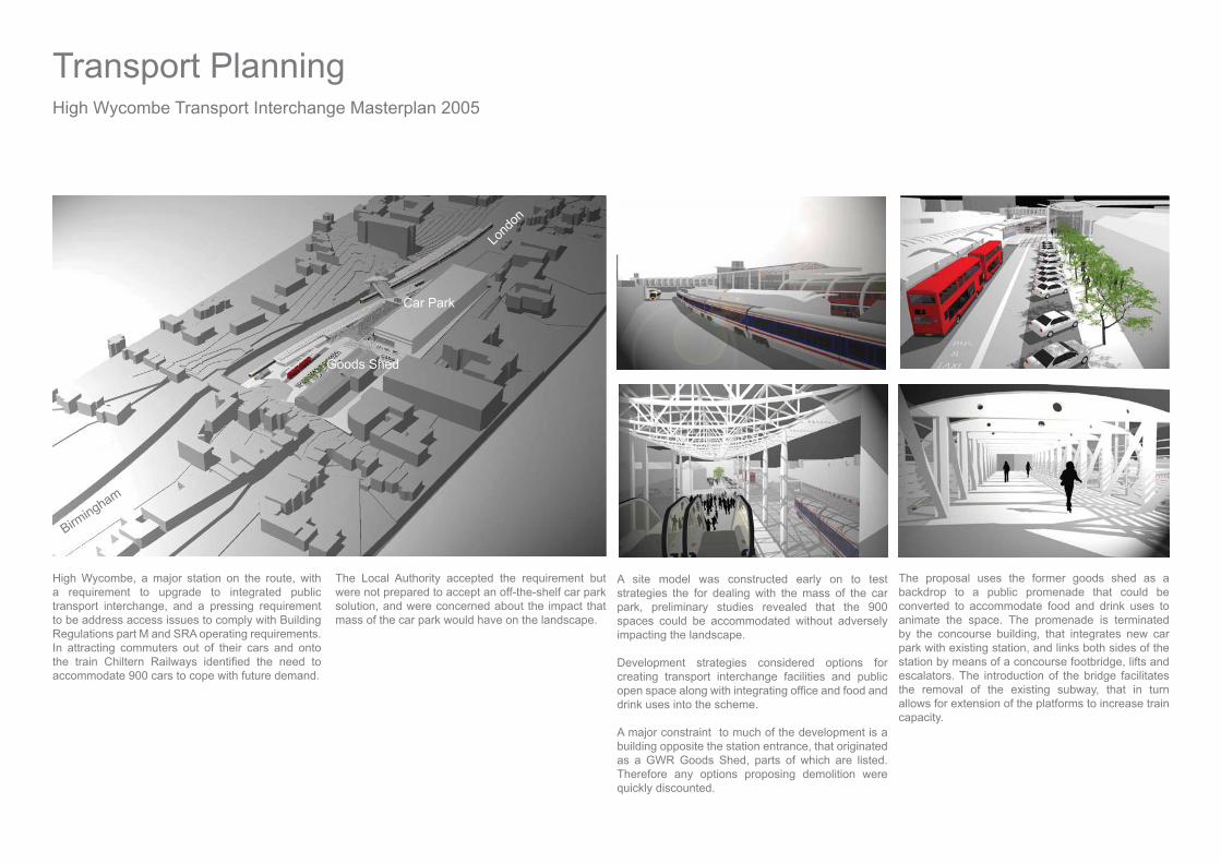
High Wycombe, a major station on the route, with a requirement to upgrade to integrated public transport interchange, and a pressing requirement to be address access issues to comply with Building Regulations part M and SRA operating requirements. In attracting commuters out of their cars and onto
accommodate 900 cars to cope with future demand.
The Local Authority accepted the requirement but were not prepared to accept an off-the-shelf car park solution, and were concerned about the impact that mass of the car park would have on the landscape.
A site model was constructed early on to test strategies the for dealing with the mass of the car park, preliminary studies revealed that the 900 spaces could be accommodated without adversely impacting the landscape.
Development strategies considered options for creating transport interchange facilities and public
drink uses into the scheme.
A major constraint to much of the development is a building opposite the station entrance, that originated as a GWR Goods Shed, parts of which are listed. Therefore any options proposing demolition were quickly discounted.
The proposal uses the former goods shed as a backdrop to a public promenade that could be converted to accommodate food and drink uses to animate the space. The promenade is terminated by the concourse building, that integrates new car park with existing station, and links both sides of the station by means of a concourse footbridge, lifts and escalators. The introduction of the bridge facilitates the removal of the existing subway, that in turn allows for extension of the platforms to increase train capacity.
High Wycombe Transport Interchange Masterplan 2005
Car Park
Goods Shed
Lond
on
Birmingham
Transport Planning

Facilities for bus interchange, short stay car parking, pick-up and drop-off are accommodated between the promenade and the existing Edwardian station building that could be retained and restored following removal of facilities to new concourse. The concourse roof uses elliptical trusses and EFTE
and high thermal performance.
Station facilities along with commercial outlets are
along with facilities for cycles, and facilities associated with car parking.
Project team:
Aedas :Architecture, Landscape, R&D. Atkins: Infrastructure.
Stakeholders:
Laing Rail: Client.Chiltern Railways.Wycombe District Council.Buckinghamshire County Council.Strategic Rail Authority.
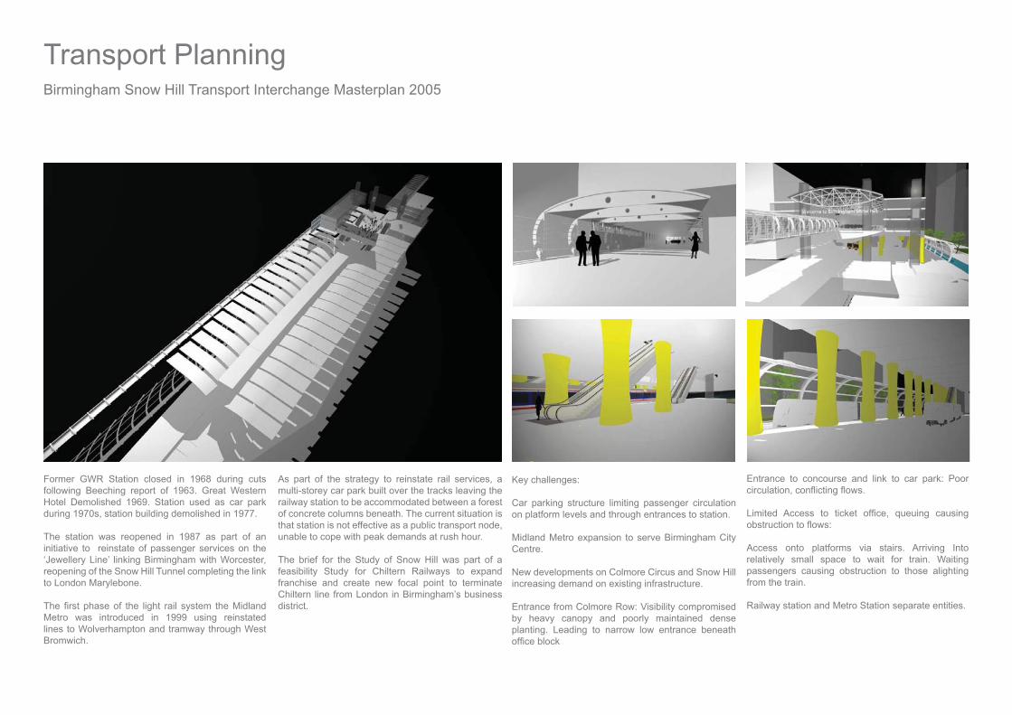
Former GWR Station closed in 1968 during cuts following Beeching report of 1963. Great Western Hotel Demolished 1969. Station used as car park during 1970s, station building demolished in 1977.
The station was reopened in 1987 as part of an initiative to reinstate of passenger services on the ‘Jewellery Line’ linking Birmingham with Worcester, reopening of the Snow Hill Tunnel completing the link to London Marylebone.
Metro was introduced in 1999 using reinstated lines to Wolverhampton and tramway through West Bromwich.
As part of the strategy to reinstate rail services, a multi-storey car park built over the tracks leaving the railway station to be accommodated between a forest of concrete columns beneath. The current situation is that station is not effective as a public transport node, unable to cope with peak demands at rush hour.
The brief for the Study of Snow Hill was part of a feasibility Study for Chiltern Railways to expand franchise and create new focal point to terminate Chiltern line from London in Birmingham’s business district.
Key challenges:
Car parking structure limiting passenger circulation on platform levels and through entrances to station.
Midland Metro expansion to serve Birmingham City Centre.
New developments on Colmore Circus and Snow Hill increasing demand on existing infrastructure.
Entrance from Colmore Row: Visibility compromised by heavy canopy and poorly maintained dense planting. Leading to narrow low entrance beneath
Entrance to concourse and link to car park: Poor
Access onto platforms via stairs. Arriving Into relatively small space to wait for train. Waiting passengers causing obstruction to those alighting from the train.
Railway station and Metro Station separate entities.
Birmingham Snow Hill Transport Interchange Masterplan 2005
Transport Planning
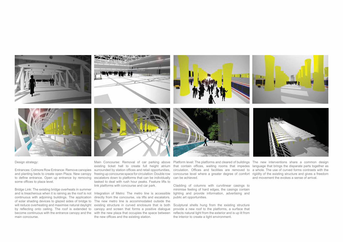
Design strategy:
Entrances: Colmore Row Entrance: Remove canopies and planting beds to create open Plaza. New canopy
Bridge Link: The existing bridge overheats in summer and is treacherous when it is raining as the roof is not continuous with adjoining buildings. The application of solar shading devices to glazed sides of bridge to will reduce overheating and maximise natural daylight
become continuous with the entrance canopy and the main concourse.
Main Concourse: Removal of car parking above existing ticket hall to create full height atrium
freeing up concourse space for circulation: Double row escalators down to platforms that can be individually tasked to deal with rush hour peaks. Feature lifts to link platforms with concourse and car park.
Integration of Metro: The metro line is accessible directly from the concourse, via lifts and escalators. The new metro line is accommodated outside the existing structure in curved enclosure that is both canopy and screen that forms a positive dialogue with the new plaza that occupies the space between
Platform level: The platforms and cleared of buildings
concourse level where a greater degree of comfort can be achieved.
Cladding of columns with curvilinear casings to minimise feeling of hard edges, the casings contain lighting and provide information, advertising and public art opportunities.
Sculptural shells hung from the existing structure provide a new roof to the platforms, a surface that
the interior to create a light environment.
The new interventions share a common design language that brings the disparate parts together as a whole. The use of curved forms contrasts with the rigidity of the existing structure and gives a freedom and movement the evokes a sense of arrival.

Al Yasmine Riyadh. Dar Al Riyadh in Conjunction with HOK 2011
290,000m2 Mixed Use Development
MasterplanningLandscapeMassing StudiesMunicipality ApplicationFull design package.
Al Yasmine Riyadh, KSA 2011
Program:
Serviced Apartments 214 Units on 17 Floors 2,600m2 Amenities
Residential Apartments 206 Units on 21 Floors 250 Units on 24 Floors 9,000m2 Amenities 292 Units on 30 Floors 3,900m2 Amenities
4 Star Hotel 352 Keys on 22 Floors4 Star Serviced Apartments 164 Units on 13 Floors4 Star Amenities 15825m2
5 Star Hotel 256 Keys on 16 Floors5 Star Amenities 13015m2
2 18 FloorsRetail 37,000m2 on 3 FloorsCar Parking 7,500 spaces on 4 basement levels
Mixed Use Development

Geoffrey Reid Associates 1999-2002
The ‘Gate’ Development as part of the regeneration of the Grainger Town area of the city centre.
The scheme comprises. Internal street-style bars and restaurants, a Sky Bar, Casino and 12-screen multiplex cinema.
The Newgate Street elevation features an 18-metre high structural glazing system giving unobstructed views through the front elevation.
The scheme won Best Mixed Use Development: Leisure Property Awards 2003
Role: Part II Architectural Assistant.
The Gate, Newcastle upon Tyne UK - 2002
Project Team:
Client: Land SecuritiesEmployers Agent: Ryder
Architects Geoffrey Reid AssociatesContractor: Sir Robert McAlpineSub contractor Barker ShepleyStructural: Waterman BBTM&E Waterman GoreLighting specialist BDP
Role:
Assembling presentation packages and preparation of planning drawings.
Assembling tender package.
Coordination of interior architecture packages, and
strategy.
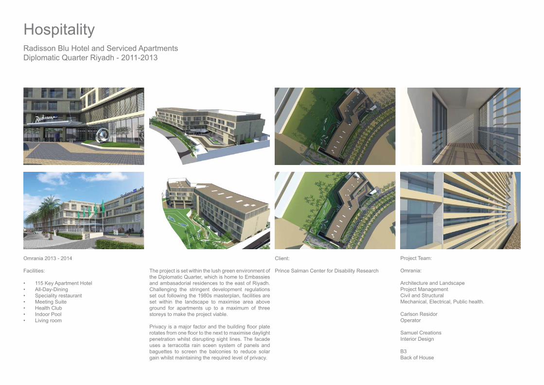
Radisson Blu Hotel and Serviced ApartmentsDiplomatic Quarter Riyadh - 2011-2013
Omrania 2013 - 2014
Facilities:
115 Key Apartment HotelAll-Day-DiningSpeciality restaurantMeeting SuiteHealth ClubIndoor PoolLiving room
Project Team:
Omrania:
Architecture and LandscapeProject ManagementCivil and StructuralMechanical, Electrical, Public health.
Carlson ResidorOperator
Samuel Creations Interior Design
B3Back of House
Client:
Prince Salman Center for Disability Research
Hospitality
The project is set within the lush green environment of the Diplomatic Quarter, which is home to Embassies and ambasadorial residences to the east of Riyadh. Challenging the stringent development regulations set out following the 1980s masterplan, facilities are set within the landscape to maximise area above ground for apartments up to a maximum of three storeys to make the project viable.
penetration whilst disrupting sight lines. The facade uses a terracotta rain sceen system of panels and baguettes to screen the balconies to reduce solar gain whilst maintaining the required level of privacy.

Dar Al Riyadh 2011
Second phase of development to upgrade former ‘Holiday Inn’ to 5 Star Hotel.
New conference centre, including Ballroom for 1,000 people, bridal suite, banqueting hall and meeting suites.
Six storey atrium linking new and existing with all day restaurant, speciality restaurant and kitchens.
New guest wing including suites, guest rooms,
Reorganisation of back of house facilities to existing hotel.
Minhal Crowne Plaza Riyadh KSA - 2011
Collaboration with IHG team.
Negotiations with Municipality
Full design package.Status: On site.

Project SLAM: 2002 - 2012SLAM: Single Living Accommodation Moderisation.
The objective of Project SLAM is to upgrade progressively the worst Single Living Accommodation to Grade 1 physical condition by 2012 in order to provide service men and women with the living environment to make them feel valued.
Client: Secretary of State for Defence
Model Standard Solution:
Managing Standards: Maintaining Model Standard Solution, a ‘Model’ building that is bench marked in terms of quality and cost which evolves over time as a continuous improvement process in conjunction with supply chain.
Maintaining Solutions Library, a comprehensive catalogue of design solutions for different ranks, situations and locations.
Development of new Model Standard Solution 2004. Delivered by CRGP 2006-2009
Development of new model Standard solution for Hotel type accommodation 2007.
Roles:
Lead Designer, Masterplanner, Project Manager.
Leading a team of 25 Architects, Landscape Architects, Architectural Technologists from 4
Shrewsbury.
Responsible for 23 accommodation projects delivering 3,400 bed spaces from inception to completion including landscape design. along with development and management of model solutions for use on all projects.
Team:
Prime Contractor: Debut, Bovis Lend Lease and Babcock Services, working in partnership with Defence Estates: Design, Construct and Manage, with 7 year compliance period.
Programme Value £1 BillionDelivery: 19000 Bed Spaces
Awards:
Considerate Contractors Gold/Silver/Bronze
Green Apple Award for Environmental Best Practice and Sustainable Development.
APM Programme of the year 2007
Sustainability:
All projects are designed to BRE standards using BREEAM Eco Homes and DREAM, working collaboratively to achieve ‘excellent’ rating. Projects are assessed on design, energy performance, site factors and construction processes
Development in Campus setting using 2002 model, 2005.
Integration with parallel programmes:
Aquatrine: Upgrade of all water services throughout the Defence estate.
Regional Prime Contracts:
Central Prime. Carillion, TPS Consult.HalcrowPRIDE : InterserveSouth West Prime, Debut, Stride Treglown.
Collaboration:
Design of individual projects, in conjunction with client teams, customer focus groups and end user groups, management of whole process from inception to completion.
Collaborative working with consultants, Supply chain, client organisation. Collaborating with Architects from Parr, Aukett, CRGP, HLM.
Leading project teams: Scott Wilson, Arup, Rybka, Hulley & Kirkwood.
Programme Delivery

Project Delivery:
The application of ‘model standard’ solutions maximise the use of off site fabrication, each individual project utilises elements from a kit of components to ensure quality across the whole project. With the standardization of building types, each project is a masterplanning process of achieving the best
requirements of each Establishment.
Development of urban courtyard solution for multiple blocks 2005. Courtyard model later applied by Aukett and HLM on other sites.
Prefabricated en suite pod being lifted into steel framed building
Prefabricated module being lifted into position
DEEP:
Projects are assessed using DEEP. (Design Excellence Evaluation Process), to ensure that the best value solution is developed.
All projects are evaluated by Designers, Debut, Defence Estates, Client Focus Team and End User Representatives.
Value Management:
Projects are developed though a collaborative process in workshops at key stages:
Value Planning, Value Management, Value Engineering.
Exemplar:
SLAM is the model for prime contracting and has been the exemplar for procurement of subsequent Government projects:
Traditional/Modular:
Projects are delivered through methods:
Modular Solution: volumetric modules that are manufactured in factory conditions and transported to site and lifted into position in stacks up to 5 stories.
Traditional Solution: Steel frame, precast planks and prefabricated bathroom pods.
All are designed to 60 year life, and exceed building regulations in terms of thermal performance.

Circulation Spine Staff Break-out and CafeAtrium
Department Offi ces
Service Tunnel
Skylight
Offi ces
h Offi ces
Skylight
Support Facilities
Solar screen
Bureau of Investigation Riyadh KSA
Omrania 2012
Investigation & Public Prosecution.
Civic and Community
Strategy of the spine
The external wall to the development is solid giving
from the harsh desert climate by concentrating activities toward the north and east facing interior of the site, that are not exposed to the direct heat of the sun to the south and west throughout the day.
All circulation is concentrated along the spine where
accommodated in the spine, along with stairs and vertical service distribution.
The Service tunnel is a continuous element running
from the chiller compound, electrical sub-station and service area. Future expansion is easily facilitated as all services are easily accessible from the tunnel.
natural daylight and provide a healthy working environment. This is achieved by orientating the
facades whilst minimizing heat gains.
through the spine from an atrium serving the facilities on the outside of the spine including the Library and Research Centre.

Omrania 2012
The project for a new Ladies Administration Building for Riyadh Municipality draws inspiration from aspects of traditional Arabic architecture in the way that it deals with privacy and climate, conveying a sense
changing attitudes in Saudi Culture.
The project is located in the busy Al Batha District in the South of Riyadh, between Al Batha Street and King Faisal Road. The aim is to provide a place where the relationship between internal and external space is expressed in a positive manner.Architectural Concept
The use of two volumes to accommodate the dual programs of administration and recreational facilities
privacy for the Ladies working in the building, whilst allowing part of the building to remain open outside
The two volumes form a protective wall around the courtyard, an external space which is completely private and self-contained from the dust and noise
oasis. The two volumes are treated differently to create a sense of drama between the formal and informal. The outer walls of the Administration Building are solid with horizontal slots, ribbon windows to permit
constant movement through the city. The inner walls
become more open to allow views of courtyard. The Facilities Building is conceived as a screen based on
a feeling of permeability at the same time as achieving protection and privacy. The eastern leg contains the lecture theatre forming a sculptural element, a focal point to the south east entrance, along with the café and social club above.
Site Planning Concept
the adjoining park as mediating space between the new Ladies Administration Building, the city and the existing Men’s Administration Building, and secondly the courtyard, mediating between the formal activities associated with administration and the informal
activities associated with learning and recreation.The park maximizes the accessibility of its frontages along Al Batha Street and King Faisal Road, to provide a safe dedicated lane for dropping off staff and visitors in both directions, and freedom of pedestrian movement through a landscaped environment where there is no need to cross a road. With vehicular circulation constrained to the park frontages, car parking is placed below in a basement level where cars are stored away from the heat during the day. The below ground car park offers increased capacity, improved circulation and creates an opportunity to update the existing park to become a high quality
with improved accessibiliy and functionality.
Riyadh Municipality Ladies Administration Building
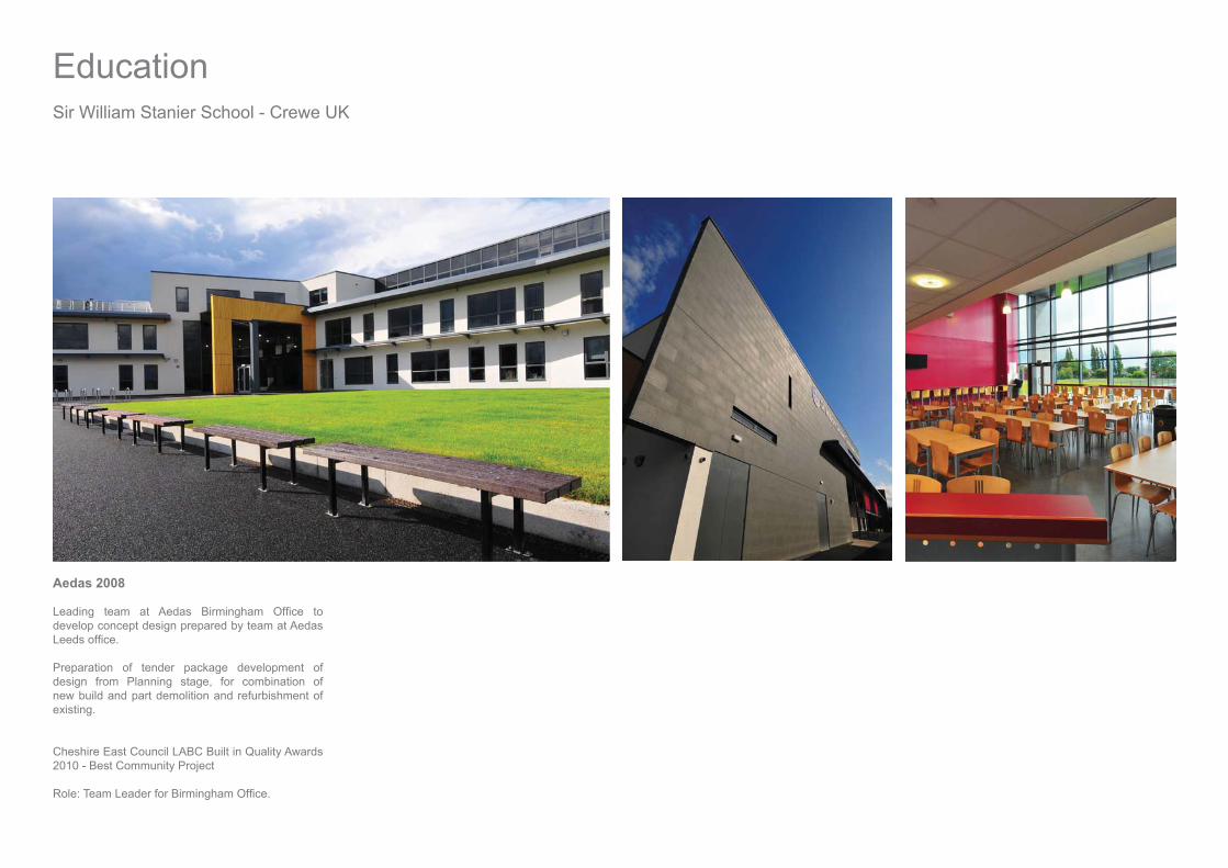
Sir William Stanier School - Crewe UK
Education
Aedas 2008
develop concept design prepared by team at Aedas
Preparation of tender package development of design from Planning stage, for combination of new build and part demolition and refurbishment of existing.
Cheshire East Council LABC Built in Quality Awards 2010 - Best Community Project
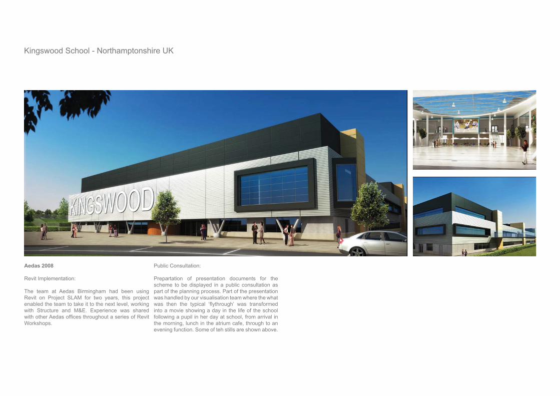
Kingswood School - Northamptonshire UK
Aedas 2008 Revit Implementation:
The team at Aedas Birmingham had been using Revit on Project SLAM for two years, this project enabled the team to take it to the next level, working with Structure and M&E. Experience was shared
Workshops.
Public Consultation:
Prepartation of presentation documents for the scheme to be displayed in a public consultation as part of the planning process. Part of the presentation was handled by our visualisation team where the what
into a movie showing a day in the life of the school following a pupil in her day at school, from arrival in the morning, lunch in the atrium cafe, through to an evening function. Some of teh stills are shown above.
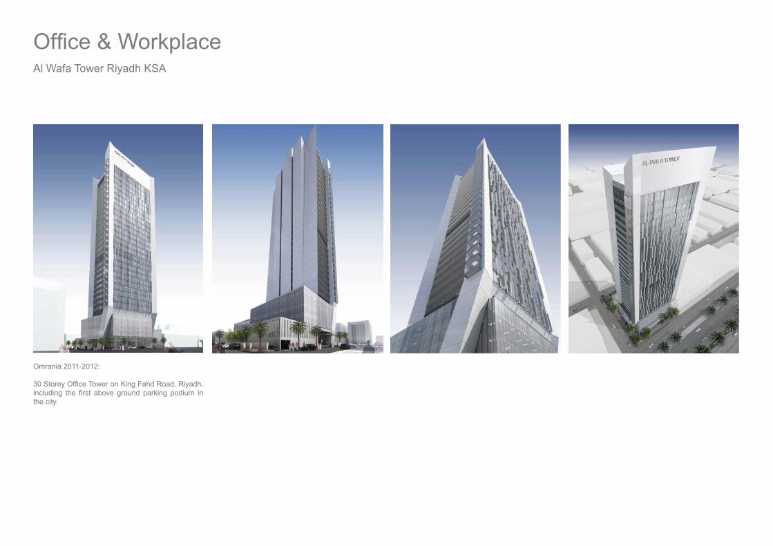
Al Wafa Tower Riyadh KSA
Omrania 2011-2012:
the city.

Saudi Food and Drug Authority Dammam KSA - 2011
Dar Al Riyadh 2010-2011
Part of a Kingdom Wide strategy to develop a standardised approach to provision of regional,
Development of regional model centred on Masterplan for new headquarters campus at Dammam to serve the Eastern Province.
sectors: along with Food, Drugs and Cosmetics, Medical Devices that could vary in size depending on population and regional requirements. Provide facilities for public access and consultation whilst
potential future provision of lecture theatre, research facilities and laboratories.
The proposal comprised, a series of modules ‘plugged in’ to a central street that extends to form
between interior and exterior, public and private, and the ability to address current and future requirements.

Sir Harry Ricardo Sustainable Transport CentreShoreham-by-Sea West Sussex UK
Aedas 2005 - 2008
Sustainable Transport Centre carrying out research into advanced fuels and lubricants, low carbon and clean technologies.
Creation of new Reception pavilion attached to
second phase comprises a scheme for reorganisation of workshop zones, including removal of collection of portakabins, brick built structures re-routing of fuel lines.
Planning approval was granted for new Reception
Phase 1 Delivery of £6.5m Reception Pavilion and
Duke of York 23rd October 2008.
Roles: Project Architect 2005 Project Manager 2008

Princes Way - Solihull. Geoffrey Reid Associates 2000
Taylor Woodrow, won at competition.
Role Part II Architectural Assistant:
Preparation Planning Application package. Development of thermal strategy. Preparation of construction information.
Princes Way Solihull UK Beaufort Court, Birmingham UK
123-127 Hagley Road Birmingham Geoffrey Reid Associates 1999
Phased development for refurbishment of 1970s of-
Role Part II Architectural Assistant:
cores and associated external works to 123 com-pleted 2002.
123-127 Hagley Road Birmingham Geoffrey Reid Associates 2002
Phased development for refurbishment of 1970’s of-
Role Project Architect: Phase 2:
and landscape scheme for whole campus.

Beneath the Surface of Architecture - Ongoing Research 2015
Do We need Architects? Published 30 June 2015
The Journey Beneath the Surface of Architecture is a journey of discovery that takes place over
become an architect, learning about architecture, the changing environment of practicing architecture and experiencing the impact of architecture on the built environment. The story investigates the meaning, perception and relevance of architecture in today’s world.
Hardcover | 6 x 9 in | 342 pages | ISBN 9781503578159 Softcover | 6 x 9 in | 342 pages | ISBN 9781503578166 E-Book | 342 pages | ISBN 9781503578173
Earth 2091
Much of Architecture creating new Urban environments, proposing new ways to live, spends a
is built.
This is a project that commenced in 2014, considering where we will be 75 years into the future. When looking back 75 years from 2014, it was 1939, the end of the heroic era of modernism and the start of the Second World War, how much has the world changed in that time, and what can we expect in another 75 years?
Beyond Suburbia: 2015
Is suburbia doing what people wanted it to do? Is it offering the healthy lifestyle, fresh air and social status associated with the ‘middle class’? What about access to services, the high street is dead, that is if it is anywhere close to the suburb in which you live, groceries are procured by a weekly shop to the nearest supermarket at the out of town shopping centre, or delivered from an online order placed to one of the supermarket chains. The local shop has been superceded by online ordering, the local pub by beer from the supermarket, where did the community go?
Reconnecting the Bay: 2015
congestion? Not necessarily, but it needs a more radical approach, some robust joined up thinking that will shift the paradigm of what the Bay is in urban terms and how it is connected by its transport network. The bay in transit terms is made up of 4 nodes, in urban planning terms, when planning new cities or regenerating existing cities and urban areas are those where the greatest concentration of activities is located in close proximity to transit nodes, where public transport come together, creating opportunities for living and working and the relationship with transit reduce the need to travel once alighting from the train or bus.
Publications, Research & Development

Zero Carbon Tower: 2010
Is it possible to develop a zero carbon tower in the hottest place on Earth?
Nature hase been achieving this for millions of years in the termite mound, a hollow tower precisely oriented to minimise peak solar gain, with subterranean living chamber that is kept cool by convection currents as hot air is drawn up through cavities in the tower.
How much of this can be applied to the human
storeys deep, and contain water tanks, mechanical plant and copious amounts of car parking. Even during construction these empty underground spaces are notably cooler than the surface. Likewise the air is
Zero Carbon House: 2008
What if it was possible to grow a house? Not exactly ‘grow’ in the traditional sense but to source the materials from managed plantations, where trees are planted at a greater rate than they are felled?
Using established techniques of prefabrication, the house arrives to site as a kit of parts, engineered
allowing for freedom of interior layout as all services are in the walls. The process radically reduces the amount of time spent working exposed to the elements on site, reduces the need for wet tradesand dramatically reduces the energy consumption both during construction and in use.
Reprogramming Paradise: 2013
Is demolition the only option for Birmingham Central Library, the iconic structure that is part of the city’s identity? With the possibility of numerous reuse options ranging from creating a museum of modernist Birmingham, to a dramatic Gallery showcasing Birmingham’s heroic restrcturing schemes, or simply something unconnected breathing new life into the
The abandoned spaces to the North and South of the library building, are cleared of ancillary structures to become a park, with a 30 storey mixed use enviromental tower fulfulling the program requirements to address the commercial needs of the city.
from the surface. The tower uses internal convection currents driven by temperature differences channelled through a central stack to drive natural cooling and generate power from air turbines in the stack. Solar PV cells are ‘woven’ into the external fabric to act as shading devices and generate electricity.
Building tall frees up more of the land area on the surface where trees can be planted to create shade
effect, reducing ambient temperatures, recucing cooling load whilst absorbing CO2.
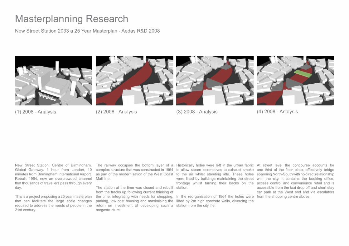
New Street Station 2033 a 25 Year Masterplan - Aedas R&D 2008
New Street Station. Centre of Birmingham. Global Gateway. 1 hour from London, 10 minutes from Birmingham International Airport. Rebuilt 1964, now an overcrowded channel that thousands of travellers pass through every day.
This is a project proposing a 25 year masterplan that can facilitate the large scale changes required to address the needs of people in the 21st century.
The railway occupies the bottom layer of a complex structure that was constructed in 1964 as part of the modernisation of the West Coast Mail line.
The station at the time was closed and rebuilt from the tracks up following current thinking of the time: integrating with needs for shopping, parking, low cost housing and maximising the return on investment of developing such a megastructure.
Historically holes were left in the urban fabric to allow steam locomotives to exhaust smoke to the air whilst standing idle. These holes were lined by buildings maintaining the street frontage whilst turning their backs on the station.
In the reorganisation of 1964 the holes were lined by 2m high concrete walls, divorcing the station from the city life.
(1) 2008 - Analysis (2) 2008 - Analysis (3) 2008 - Analysis
At street level the concourse accounts for
spanning North-South with no direct relationship
access control and convenience retail and is accessible from the taxi drop off and short stay car park at the West end and via escalators from the shopping centre above.
(4) 2008 - Analysis
Masterplanning Research

Improvements were made in 1989 following the
entrance on Navigation Street was added to relieve some of the congestion.
Above the station, the car park and shopping centre form a podium that accommodates
of an approach favoured by the city planners in the 1960s and 1970s.
(7) 2008 - Analysis (8) 2008 - Analysis
parking following the philosophy of the 1960s where as much emphasis was placed on the convenience of parking in the shopping centre as providing convenient access to trains.
Sitting above the concourse and car park is the retail podium known as the Pallasades Shopping Centre, conceived as part of the Bull Ring Centre with its ‘Grand Parade’ a series of air-conditioned corridors lined with shops providing a complete indoor experience away
route from the City centre to the Station below.
(5) 2008 - Analysis (6) 2008 - Analysis

The podium also accommodates a further six levels of car parking, much of which is in a poor state of repair and under-used.
(9) 2008 - Analysis
The servicing of the retail units in the podium takes place above. A sizeable loading and storage warehouse along with service road render much of the top of the podium a major constraint in terms of facilitating future development.
(10) 2008 - Analysis
A scheme is currently under-way to reorganise the main concourse, and over clad the retail podium to give the station a face lift, but with the existing constraints the scheme is limited
redevelopment like that of the 1960s is no longer possible the use of the station is a vital lifeline to the city.
(11) 2012 - Facelift (12) 2015 - Urban Repair
The latest generation of underground stations constructed in London around the year 2000 have demonstrated that good quality environments can be created without the need
of a gradual reorganisation is to repair the urban fabric opening up new opportunities to address access issues.
New Street Station 2033 - Aedas R&D 2008
Masterplanning Research
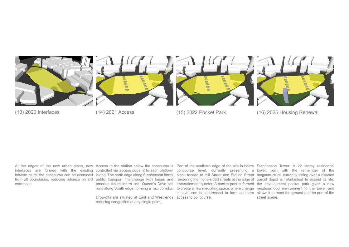
At the edges of the new urban plane, new interfaces are formed with the existing infrastructure: the concourse can be accessed from all boundaries, reducing reliance on 2-3 entrances.
(13) 2020 Interfaces (14) 2021 Access
Access to the station below the concourse is controlled via access pods: 2 to each platform island. The north edge along Stephenson forms public transport interchange with buses and possible future Metro line. Queen’s Drive still runs along South edge, forming a Taxi corridor.
Drop-offs are situated at East and West ends reducing congestion at any single point.
(15) 2022 Pocket Park
Part of the southern edge of the site is below concourse level, currently presenting a blank facade to Hill Street and Station Street rendering them one-sided streets at the edge of entertainment quarter. A pocket park is formed to create a new mediating space, where change in level can be addressed to form southern access to concourse.
(16) 2025 Housing Renewal
Stephenson Tower: A 22 storey residential tower, built with the remainder of the megastructure, currently sitting over a disused parcel depot is refurbished to extend its life, the development pocket park gives a new neigbourhood environment to the tower and allows it to meet the ground and be part of the street scene.

As demand for accommodation in the city grows, city centre land is at a premium. To facilitate the formation of new urban plane part of the area is allocated for tower development. Programs are built into the towers to comprehend future needs. Towers designed to accommodate multiple programs form new gateway to the city.
The Gateway Tower is a landmark, at the base
space between New Street Station and the Civic Quarter. Pick-up and drop-off at the edge of the square, travellers make the short walk across the square to the concourse.
(19) 2033 Urban Gateways (20) 2033 Western Gateway
With the pocket park dealing with the two transition between concourse and street, new low rise blocks are erected to address Queen’s Drive at the higher level and Hill Street and Station Street at the lower level, vibrant mix of uses gives life to both frontages.
Development concentrated around the perimeter with street orientated uses reduce demand for retail in the podium. Shopping centre can be vacated freeing up the storage depot above, along with the car parks, allowing for their removal. Ladywood house upgraded.
(17) 2027 Urban Frontage (18) 2030 Podium Reorganisaton
New Street Station 2033 a 25 Year Masterplan - Aedas R&D 2008
Masterplanning Research

The erosion of the podium creates a public
accommodated in the remaining elements of the podium to the north and south, leaving the east west route free forming an open diologue with the public travelling along the concourse, the use of circulation pods allows concourse to be an extension of the urban plane.
(21) 2033 Open Concourse
Circulation pods punctuate the space giving
areas, dealing with the mix of people arriving, departing, awaiting arrivals. People with time to spare before departure can spend time in retail environment, cafes, bars all in sight of main concourse.
Eastern Gateway: Pick-up and drop-off at the edge of the square. A new mediating space between New Street Station, Bull Ring Centre and markets quarter, making all the activities integrated at street level.
In an ever changing context a 25 year plan sets up a framework where incremental change can take place gradually transforming a neglected megastructure into a lively transport node, where transport is an integral part of the urban fabric.
(22) 2033 Open Concourse (23) 2033 Eastern Gateway (24) 2033 City Centre

R & D coordinator Aedas Birmingham.
The Aedas R&D community was established in 2005 as an initiative to share knowledge and expertise
that would channel research activities to align with activities nationally and increase the sense of
Aedas Aim: To create an internal R+D Community to:
Develop strategic policies Initiate cutting edge research Collaborate with external bodies Produce design and technical guidance Transfer Tacit knowledge Develop and promote expertise
Aedas R&D Community - Focus Groups
SustainabilityAdvanced Modelling GroupUrban Design and MasterplanningTall BuildingsNew materialsPartnering & procurementIntegrated Internal EnvironmentsPost occupancy evaluationCultural and Vernacular Architecture
Urban Design and Masterplanning Group - Team Leader.
Collating and disseminating information relating to Urban Design and Masterplanning Issues:
Urban Design GroupRUDICABE
Establishing links with Birmingham School of Architecture.
Volunteer Critic 2005 -2007 Visiting Tutor 2007-2008
Aedas R&D Community 2005-2010
Research & Development

Attending conferences:
CityscapeRegional Sustainability Forum
Writing research papers for internal publication. through Aedas’ intranet, (WikiAedas)
Transformation of the Bull RingBirmingham New Street
Development of design guides, checklists to give
analysis.
Working alongside Sustainability Group, Advanced Modelling Group
EcotectRevit
Collating project information throughout the Global Aedas organisation for use in competitions and bids along with ongoing masterplanning projects.
Training Coordinator.
Mentoring of individuals in establishing training
implementing national training programme.
CPD Coordinator
Arranging seminars with suppliers, training providers, local authority.Coordinating with external CPD events:
RIBABirmingham Architectural Association.BirminghamSchool of Architecture
Sustainability Champion 2009-2010
As part of evolution of the R&D community Sustainability and Advanced Modelling became
The Aedas Green Book was published as a comprehensive design guide, that dealt with not only
design but also developed guidance on company processes, from travel to volume of paper used down to turning off computer monitors at the end of the day.
Alongside the Green Book came the Green tool, a comprehensive method of evaluating building energy performance and comparing with design, with a very real opportunity to feed back into the design process for future projects.
The work undertaken as the Urban design and Masterplanning fed into the establishment of Masterplanning Focus Group in 2010 as shared
focus onto becoming more than an R&D activity.

Expression of interest for Eastside City Park Competition 2006
Eastside City Park: a 21st Century Park
Role: Team Leader. The exercise was one of demonstrating that we (Aedas) could assemble a team of professionals and work across continents to bring the best expertise to the table from the collective knowledge of individuals throughout the practice, including input from Landscape and Environment in the UK, Urban design input from Hong Kong and
Aedas R&D Community 2005-2010
Event - Experience - Memory
Events that have happened are part of the collective memory of the city. Current events, sometimes ephemeral, sometimes recorded to become part of the future collective memory both forming part of the city’s Identity.
Part of the Birmingham experience is captured through anthropological study of current events/activities occurring in the city, along with analysis of programs for future events.
Through this process current trends and future aspirations are mapped and gauged for the city. The park begins to interact with progressive heritage, by hosting ongoing events that will be recorded as history.
The design is an Intervention into this process and is an essential component of shaping future events.
The park forms a stage, backdrop, framework, the infrastructure that supports events, whether organised or spontanaous, intended or unintended, the use of media and technology to network activities with the rest of the city.
Research & Development

Bull Ring Study 2006
The New Bull Ring – ‘Europes new shopping capital’Advertisement 2003
This is essentially a shopping centre that claims to be a new part of Birmingham but does it display any evidence of Urban Design?
Research Paper on transformation of Birmingham’s Bull Ring Centre of the 1963s to new Bull Ring opened in 2003.
From the walk down High Street towards a glass façade with a bronze bull in front of it. The street is populated with solid sculptural granite blocks set into the new topography, that act as benches or seats.
The street slopes up towards the entrance to the west mall then down towards the anchor store which is Debenhams on this side.
The Central Mall is a 3 storey void surrounded by shops with wide bridges and massively overcrowded escalators, transporting people down into the mall.
A walk along the Mall at low level passes food outlets with street style seating outside, with glimpses through to the outside where St Martins Church sits in its new surroundings.
On the middle level of the Central Mall, the internal environment meets the external as the mall is
newly restored statue of Lord Nelson.
At the edge of what is now called Nelson Square,
reading as an archaeological dig where the newly restored 11th century church has been unearthed in an excavation.
The plaza forms a small space for events, temporary pavilions, craft fairs, market stalls; the main market nowdisplaced to the south away from its historic setting.
Selfridges is a building conceived as a department store without windows has a positive relationship with its surroundings with multiple walkways penetrating the façade at different levels. The gently curving volume encompassing St Martins.

Madinah Gate Design Competition 2012
Omrania 2012
The Gate is conceived as a landmark, announcing arrival at Al Madinah. First read from a distance as a marker on the horizon. As the gate is approached the calligraphy becomes visible descending from the tip of the sculpture and forming a canopy that casts strong shadows on the ground as the visitor passes through the checkpoint. The calligraphy and the casting of shadows is a unifying element to the scheme.
The Village is accommodated beneath a shade
function.
Firstly, creating covered squares where it is possible to sit outside and enjoy the atmosphere without the constant hum of air-conditioning units; and secondly the canopy casts shadows on the ground and the roofs of the pavilions, this minimises the heat island effect, reducing the amount of solar radiation that is
Where the canopy directly oversails the pavilions solar photo voltaic cells increase the amount of shade offered whilst generating electricity that will contribute to the energy demands of the village.
The village makes use of shade from the regular grid of date palms that are a constant feature of the site, along with planted beds that further reduce the heat island effect, in addition, water features contribute to the natural cooling of the environment, minimising the load placed on any cooling plant.
The Gate straddles both sides of the road, but as it enters the Village, the structure diminishes to become
Shaded Promenade, connecting all the vehicular entrances and exits, park, amenities of the Village, central plaza and the Mosque.
The Village is designed as a sustainable urban quarter following the compact city approach that is prevalent in the traditional Arabic village; narrow spaces and shaded walkways that make browsing around shops and stalls a pleasurable experience.
Competitions

The village is comprised of standardised glass pavilions that are slotted in beneath the canopy, heat gains are dealt with by the canopy, meaning that the
Date palms have recently become a feature of new highway construction as the central median is planted as part of the process.
Here the palms are concentrated to provide a naturally shaded environment where fruit and vegetables can thrive in a managed environment.
Palm Groves are synonymous with the landscape surrounding Al Madinah, oases naturally occurring in the volcanic landscape are a sharp contrast with the arid climate of the region.
Dates grown around Al Madinah are widely rated as
the world.

Bab Al Bahrain Ideas Competition January 2012
The site is a ‘Living Archive’ where Bahrain’s memory is manifested through a new urban plane where the shoreline changes over the past 110
or visiting can discover events that have shaped the past, events that are happening in the present, and events that are planned for the future co-exist in the same place.
‘Memory of The Sea’
Competitions

Mount Rahmah To Mina Covered Pedestrian Walkway Dar Al Riyadh - August 2011
Drawing inspiration from a parasol, sculptural ribs spread out to support a high canopy that casts intense shadows onto the promenade below, protecting pilgrims from the harsh heat and occasional heavy rains along the Hajj. The individual canopies combine to form a dramatic spine to a linear park whilst remaining sensitive to the landscape.

Competitions
Credenhill House: Aedas Internal Design Competition 2008
How do you plan a sustainable build comprising a large house in heart of rural Herefordshire,
and kitchen all pointing to a sizeable volume built on a hillside in the ‘green belt’?
House Project - 2008
The project is a demonstration of how the design of the house can support a sustainable lifestyle and at the same time make a positive contribution to the landscape. The design is conceived as a self consciously engineered timber and glass pavilion emerging from the hillside; something that is cutting edge design in terms of technology and performance that sits comfortably with its rural context.
In promoting a sustainable lifestyle the house comprises three distinct elements: living space, working space and garden. The working space minimises the need to travel, the garden offers opportunities to grow vegetables on site and minimise the need for transport, contributing to big picture low carbon reduction.
The work environment is situated on the lower level, cut into the hillside, comprising a reception space for visitors and main open plan working space
pool to maximise natural daylight penetration into the spaces, whilst creating a tranquil setting that is both separated from and connected with the outside world.
The upper level accommodates sleeping rooms on east end, living spaces south facing onto the courtyard, with entertaining spaces on the west end giving dramatic views over the landscape whilst maximising solar exposure using both active and passive solar design principles, to harness solar
radiation. The construction system uses a combination of engineering, prefabrication and sustainable materials. The wall construction is an engineered timber panel system, based on a 2.4m module to maximise use of standard components. The panel is made up of a softwood frame harvested from sustainable plantations with ply on both sides. The wall construction totals 600mm thick, with its internal void packed full of insulation, shredded newspaper, wool, straw, whatever is most readily available, with ventilated timber rain screen on the external leaf, its outer surface made up of Oak boards which will provide a surface that is robust against the elements and will weather down naturally over time.

Aedas internal competition 2004.
Design of the livery for Aedas sponsored Formula Palmer Audi race car for Jonathan Kennard.
The Competition win resulted in attending a race weekend at Monza. My wife and I arrived just in time
second session, viewed from the pit wall. Settled in at
win. Arrived at the track on Sunday morning, a good time to be wearing an Aedas shirt as the car was completely surrounded by the great and good that frequent the paddock.
Formula Palmer Audi - 2004
Second race viewed from the main grandstand a hard fought win rounding off a great weekend for Mr Kennard, and a great weekend for Team Dolton, not bad for ten minutes work on Photoshop, happy days!
Jonathan went on to win 2004 FPA Championship

MarketingExhibition Pavilion for Cityscape Riyadh,December 2011
Omrania and Associates 2011
Design of pavilion for Cityscape Riyadh:
Omrania’s projects and conribution to the city of Riyadh.
Pavilion Concept: To demonstrate the contribution of Omrania to the cityscape of Riyadh since 1973 using large scale map, graphics and models.
Marketing Role:
Developing presentation and publication template
Manama, Riyadh, Amman. Training support staff in
proposal documentation.
Compilation of graphic database of all projects.
Design input: Site Analysis, Project program analysis and project description. Project methodology, List of deliverables, selection of appropriate projects to demonstrate relevant experience.
King Abdullah Medical City, BahrainCentury City Doha, Qatar
Technical Proposals:
King Abdullah Medical City, BahrainCentury City Doha, QatarDiyar Al Muharraq Town Centre
Diyar al Muharraq International SchoolNAMA Tower Bahrain BayResidential Tower Kuwait CityDannat Resort Half Moon Bay Eastern Province KSAO’Bear Resort, Near Wadi Hanifah RiyadhMixed Use Development Dammam KSARetail Development Masterplan for IKEA Ad Diryah KSA

Leisure Complex Riyadh
Mixed Use Development Parcels, King Abdullah Economic City (KAEC) Western Province KSA.Residential Masterplan King Abdullah City for Science and Technology (KACST) Riyadh KSA