Embed Size (px)
Citation preview
Saez-Rodríguez. A. (2012). An Ethnomathematics Exercise for Analyzing a Khipu Sample from Pachacamac
(Perú). Revista Latinoamericana de Etnomatemática. 5(1). 62-88
62
Artículo recibido el 1 de diciembre de 2011; Aceptado para publicación el 30 de enero de 2012
An Ethnomathematics Exercise for Analyzing a Khipu Sample
from Pachacamac (Perú)
Ejercicio de Etnomatemática para el análisis de una muestra de quipu de
Pachacamac (Perú)
Alberto Saez-Rodríguez1
Abstract
A khipu sample studied by Gary Urton embodies an unusual division into quarters. Urton‟s research findings
allow us to visualize the information in the pairing quadrants, which are determined by the distribution of S-
and Z-knots, to provide overall information that is helpful for identifying the celestial coordinates of the
brightest stars in the Pleiades cluster. In the present study, the linear regression attempts to model the
relationship between two variables (which are determined by the distribution of the S- and Z-knots). The
scatter plot illustrates the results of our simple linear regression: suggesting a map of the Pleiades represented
by seven points on the Cartesian coordinate plane.
Keywords: Inca khipu, Linear regression analysis, Celestial coordinate system, Pleiades.
Resumen
Una muestra de quipu estudiada por Gary Urton comporta una división por cuadrantes poco común.
Utilizando dicho hallazgo de Urton, podemos visualizar la información contenida en los pares de cuadrantes,
la cual está determinada por una distribución de nudos con orientaciones opuestas de „S‟ y de „Z‟,
brindándonos, así, toda la información necesaria para identificar las coordenadas celestes de las estrellas más
brillantes del cúmulo de las Pléyades. En el presente estudio se usa el análisis de la Regresión Lineal con el
fin de construir un modelo que permita predecir el comportamiento de la variable dependiente y (valores de
los nudos con orientación de „Z‟) en función de la variable independiente x (valores de los nudos con orientación de „S‟). Dicho modelo se logró usando un diagrama de dispersión, lo que nos condujo a un mapa
con la posición de las siete estrellas más brillantes de las Pléyades, como un modelo empírico de la relación
que mantienen las variables en estudio.
Palabras clave: Quipu, Análisis de regresión lineal, Sistema de coordenadas celeste, Pléyades.
1 Dr. Alberto Saez-Rodriguez is affiliated with the Department of Economic Planning and Statistics, Peoples'
Friendship of Russia University, RUDN, Moscow, Russia. Email: [email protected]
Revista Latinoamericana de Etnomatemática Vol. 5, No. 1, febrero-julio de 2012
63
Introduction
D‟Ambrosio (1997) used the term „ethnomathematics‟ mostly associated with mathematics
practiced in "cultures without written expression". The Incas had developed a method of
recording numerical information which did not require writing. It involved knots in strings
called khipu. According to Orey (2000, p. 250), the application of “ethnomathematical
techniques and the tools of mathematical modelling allows us to see a different reality and
give us insight into science done in a different way”.
Khipu Recording in the Inca Empire
The khipu is the most complex non-alphabetic recording system known from the ancient
world, but its techniques of information registry have eluded scholars for centuries. The
broader impacts of the study of the khipu can be compared with those of other ancient
writing/recording systems (for example, Sumerian cuneiform and Mayan hieroglyphs).
Deciphering khipus is an exceedingly difficult task because we lack the equivalent of a
Rosetta Stone for khipus, and this study presents one of several possible solutions to this
puzzle. In this study, I explore this ancient and potentially powerful system of coding
information from the pre-Columbian South America. The numerical data recorded in khipus
were calculated by means of decimal and „fortiethal‟ yupanas (In Quechua yupar means “to
count”), using the Fibonacci arithmetic system: 1 2n n nF F F , and powers of 10, 20 and
40 as place values for the different fields in the instrument.
While numerous Spanish chronicles in Peru left accounts of the khipu that inform us on
certain features and operations of these devices, none of these accounts is extensive or
detailed enough to put us on solid ground in our attempts today to understand exactly how
the Inca made and consulted these knotted and dyed records. Urton (2003, p. 53) notes that
“Our own challenge today is to seek by every means possible to try to understand and
appreciate the full range and potential of record keeping that the Inca realized in their use of
this device.”
The former Inca record keepers, known as khipukamayuq (knot makers/keepers), supplied
Inca rulers with a colossal variety and quantity of information pertaining to censuses,
accounting, tributes, ritual and calendrical organization, genealogies, astronomical
Saez-Rodríguez. A. (2012). An Ethnomathematics Exercise for Analyzing a Khipu Sample from Pachacamac
(Perú). Revista Latinoamericana de Etnomatemática. 5(1). 62-88
64
observations (Zuidema, 1982), and other such matters. In general terms, khipus are
composed of a primary cord to which a variable number of pendant strings are attached (see
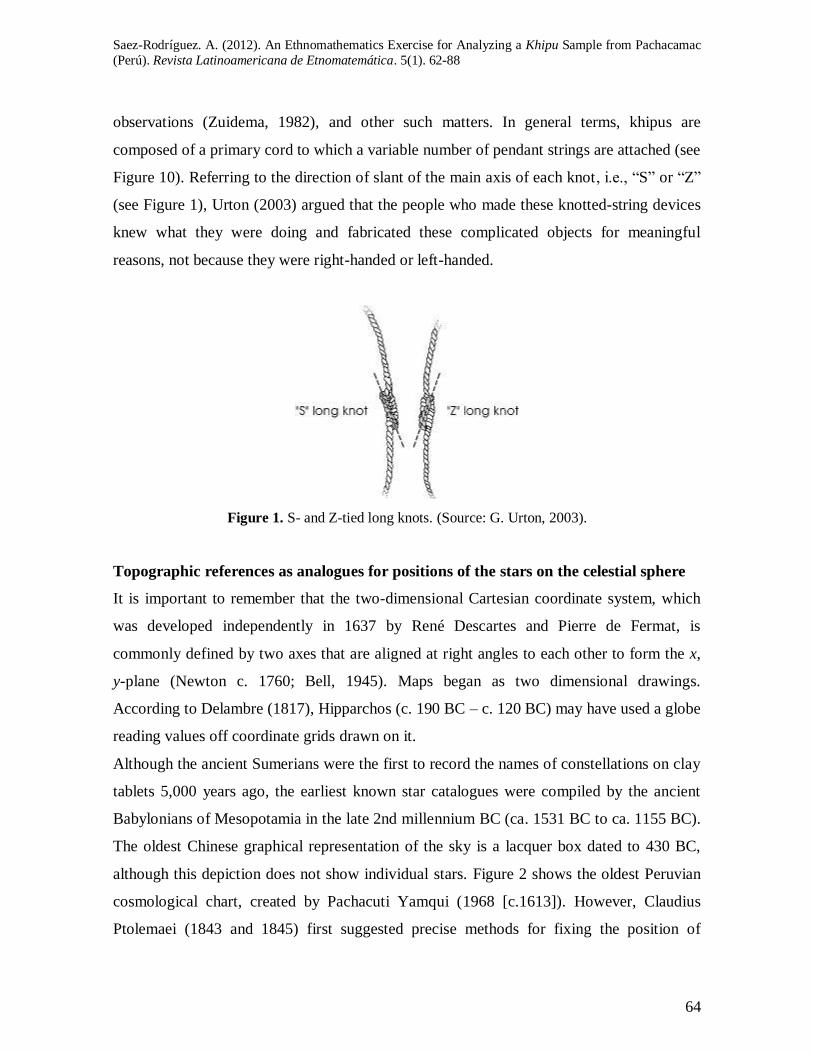
Figure 10). Referring to the direction of slant of the main axis of each knot, i.e., “S” or “Z”
(see Figure 1), Urton (2003) argued that the people who made these knotted-string devices
knew what they were doing and fabricated these complicated objects for meaningful
reasons, not because they were right-handed or left-handed.
Figure 1. S- and Z-tied long knots. (Source: G. Urton, 2003).
Topographic references as analogues for positions of the stars on the celestial sphere
It is important to remember that the two-dimensional Cartesian coordinate system, which
was developed independently in 1637 by René Descartes and Pierre de Fermat, is
commonly defined by two axes that are aligned at right angles to each other to form the x,
y-plane (Newton c. 1760; Bell, 1945). Maps began as two dimensional drawings.
According to Delambre (1817), Hipparchos (c. 190 BC – c. 120 BC) may have used a globe
reading values off coordinate grids drawn on it.
Although the ancient Sumerians were the first to record the names of constellations on clay
tablets 5,000 years ago, the earliest known star catalogues were compiled by the ancient
Babylonians of Mesopotamia in the late 2nd millennium BC (ca. 1531 BC to ca. 1155 BC).
The oldest Chinese graphical representation of the sky is a lacquer box dated to 430 BC,
although this depiction does not show individual stars. Figure 2 shows the oldest Peruvian
cosmological chart, created by Pachacuti Yamqui (1968 [c.1613]). However, Claudius
Ptolemaei (1843 and 1845) first suggested precise methods for fixing the position of
Revista Latinoamericana de Etnomatemática Vol. 5, No. 1, febrero-julio de 2012
65
geographic features on its surface using a coordinate system with parallels of latitude and
meridians of longitude.
The celestial coordinate system, which serves modern astronomy so well, is firmly
grounded in the faulty world-view of the ancients. They believed the Earth was motionless
and at the center of creation. The sky, they thought, was exactly what it looks like: a hollow
hemisphere arching over the Earth like a great dome. When the ancient Incas looked up at
the night sky, they described it simply as it was seen.
Ancient Incan Astronomy
Early astronomers used many instruments to study the heavens. There is some evidence to
suggest that Incan astronomers used several tools to chart the position of objects in the sky
and to predict the movements of the sun, moon, and certain stars (see Figures 4 and 6). All
of these tools were basically tools for measuring or calculating the positions of objects in
the sky. Within the limits of naked eye astronomy, they used a variety of basic
observational techniques. Later, they used very simple instruments to define, monitor, and
predict the motion of celestial objects (Krupp, 2003). What tools did Incan astronomers
use? During the Spanish conquest of the Incas, the Spanish melted down all of the Incan
gold artefacts they could find. It is impossible to imagine how many artefacts the Spanish
conquerors might have destroyed. Once the invaders found a new temple, they looted it,
collected all of the gold and silver they found, melted it, made coins from it, and shipped it
to Spain.
Hiltunen (2003) used astronomical phenomena described in Montesinos‟ chronicle (1920,
originally published in 1644) as historical evidence. His approach attempted to link
astronomical phenomena with historical events that were described in Montesinos‟
chronicle. Montesinos (1920, originally published in 1644) speaks of the appearance of two
comets during the reign of Yupanqui; one had the form of a lion, and the other had the form
of a serpent. According to Hiltunen (2003), when historical narratives contain well-
documented and contextually credible descriptions of eclipses or comets, they can be a
useful method to synchronize oral traditions within an absolute chronology. In Montesinos‟
chronicle (1920 [1644]), several such references exist, but these are poorly documented and
Saez-Rodríguez. A. (2012). An Ethnomathematics Exercise for Analyzing a Khipu Sample from Pachacamac
(Perú). Revista Latinoamericana de Etnomatemática. 5(1). 62-88
66
contextually dubious. Fortunately, good manuals exist that can be used to check
occurrences of eclipses, comets, and even supernovae, thereby yielding an extensive
historical perspective. Hiltunen (2003) first tested this idea with Incan historical records
and found that references to extraordinary astronomical phenomena that occurred shortly
before the arrival of the Spaniards can be correlated quite well (although these cases may,
at least partly, be later interpolations intended to impute a prognosticated drama to these
events). Montesinos also gives one such reference for Incan times, which may be relevant.
In this reference, Cobo (1990, pp. 27–29) and Garcilaso (1966, pp. 118–119) wrote that
when a solar eclipse occurred, the Incas would consult their diviners, who usually
determined that a great prince was about to die and the Sun had thus gone into mourning.
Lunar eclipses were thought to occur because a puma or snake was eating the moon. The
Memoirs of Garcilaso mention one comet that appeared at the time of the death of the Inca
Huascas and another that was visible for some time afterward (while Atahualpa was a
prisoner of Pizarro).
Combining statements of Bernabé Cobo ([1635] 1956, II, pp. 160–161), and Francisco de
Avila ([1608] 1966, cap. 29), the Incas‟ model of the celestial sphere was as a solid. Thus,
we can suppose that their choice to use the ecliptical coordinates was reasonably
convenient for this theory. But when it came to practical observation, the measurement of
ecliptical coordinates was more complicated than the equatorial coordinates. According to
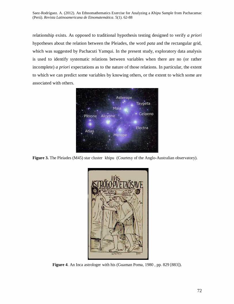
Guaman Poma de Ayala (Figure 4, 1980 [1615], pp. 829 [883]), one member of the class of
Inca officials was specializing in astrological khipu. As Figure 4 shows, the Inca astrologer
is represented as a man carrying a fork-like observation instrument, and a khipu.
The Ceque System
The so-called Cuzco ceque system was first studied by Polo de Ondegardo, in Cuzco whose
inhabitants gave him drawings of their plans (Durán, 1981) [1559]. He also explicitly refers
to the calendrical use of the system in Cuzco but does so with giving only a few clues for
solving that problem. However, no chronicler provides a sufficiently full account of that
use.
Revista Latinoamericana de Etnomatemática Vol. 5, No. 1, febrero-julio de 2012
67
According to many accounts of Indian life and lore written in Spanish shortly after the
conquest of Cuzco was planned in such a way that the main temple was located at the
confluence of 42 lines, called ceques (Quechua for "lines"), each containing a varying
number of huacas. The ceque system in Cuzco had 328 huacas (shrines), which is the same
number as the number of days in 12 sidereal months. The ceque system included a complex
series of shrines and imaginary lines that radiated out from the centre of Cuzco and had
astronomical, calendrical, and sacred connotations. The ceques were grouped into four
quadrants, each corresponding to one of the four “parts” of the state. This system provided
the foundation for Zuidema's (1964, 1977, 1982) interpretation of the Incan calendar.
Tom Zuidema (1964, 1977) was the first to recognize the relevance of astronomy in the
structure of the ceque system. The ceque system as a whole is connected with the Inca
lunar-stellar calendar, and several of the line orientations have an astronomical origin and
mark relevant astronomical phenomena at the horizon, such as the rising of the sun at the
solstices. In Guaman Poma‟s drawings (1980 [c. 1615]), grids were also employed in
Andean spatial organization.
In his article, Gartner (1998, p. 2) asks the following question concerning gridlike
geometric structures: “How does one identify a map from a culture whose conceptions of
space, geographic relations, mode of representation, and media are very different from
Western experience?”. In the present study, I will attempt a review of Gartner‟s work and
mention some relevant facts that are of importance to the origin and the planning of the
coordinate system.
In the of Exsul Immeritus‟ diagram (Miccinelli Collection), Zuidema (2004) has assigned to
each huaca one degree in a circle of 365° (and thus not of 360°). During the remaining
period of 37 days, as indicated, this primarily agricultural calendar did not operate. I would
suggest that the Incas divided the celestial sphere into 365 degrees. As a tropical year has
365 days, each day the sun moves one degree on the celestial sphere. Yet most ancient
astronomers adopted the Babylon division, dividing the celestial sphere into 360 degrees.
Saez-Rodríguez. A. (2012). An Ethnomathematics Exercise for Analyzing a Khipu Sample from Pachacamac
(Perú). Revista Latinoamericana de Etnomatemática. 5(1). 62-88
68
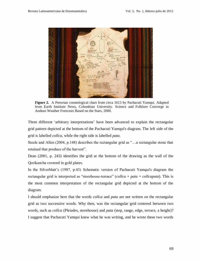
Pachacuti Yamqui's Diagram of Inca Cosmology
The chart in question (see Figure 2) shows objects depicted on the Temple of the Sun,
Qorikancha, in Cuzco, adding Spanish and Quechua notations. These objects are: Orion on
the upper left, the southern cross at the center, seven Pleiades; solar system objects: the
Sun, the Moon, Venus as morning and evening star; meteorological objects: the rainbow;
natural “earthly” objects: the surface of the earth, the sacred tree; and finally, a rectangular
grid depicted below the seven Pleiades.
The extraordinarily crafted Temple of the Sun at Qorikancha (Cuzco) was the most
sumptuous temple in the Inca Empire. Some 4,000 priests and their attendants once lived
within its confines. Qorikancha also served as the main astronomical observatory for the
Incas. In addition to hundreds of gold panels lining its walls, there were life-size gold
figures, solid-gold altars, and a huge golden sun disc. The golden sun disc reflected the sun
and bathed the temple with light. During the summer solstice, the sun still shines directly
into a niche where only the Inca chieftain was permitted to sit.
The Qorikancha 's Rectangular Grid and the Incan pseudo Longitudes and Latitudes
At the bottom of the Pachacuti Yamqui's diagram we can see seven points corresponding to
the seven visible stars of the Pleiades. Below the representation of the 7 stars we can clearly
see a rectangular grid. The Pachacuti Yamqui's rectangular grid consists of 7 horizontal and
18 vertical lines, meeting each other at right angles and thus forming a rectangular grid, like
a Cartesian coordinate system in two dimensions. If we observe the position of the
rectangular grid, we notice that it was depicted between two key words, such as collca
(Pleiades) and pata (Quechua for step, range, edge, terrace, a height), i.e., on the left side of
the grid we can read the word “collca”, while on the opposite side the word “pata” is easily
readable.
According to Pachacuti Yamqui (1968), the Temple of the Sun at Qorikancha was the
location of a plaque that depicted the Inca cosmos, providing a map of this cosmos depicted
on a paper sheet. As Figure 2 shows, an important part of this image is the rectangular grid
depicted by Pachacuti Yamqui at its bottom.
Revista Latinoamericana de Etnomatemática Vol. 5, No. 1, febrero-julio de 2012
69
Figure 2. A Peruvian cosmological chart from circa 1613 by Pachacuti Yamqui. Adapted from Earth Institute News, Columbian University. Science and Folklore Converge in
Andean Weather Forecasts Based on the Stars, 2000.
Three different „arbitrary interpretations‟ have been advanced to explain the rectangular
grid pattern depicted at the bottom of the Pachacuti Yamqui's diagram. The left side of the
grid is labelled collca, while the right side is labelled pata.
Steele and Allen (2004, p.148) describes the rectangular grid as “…a rectangular stone that
retained that produce of the harvest”.
Dean (2001, p. 243) identifies the grid at the bottom of the drawing as the wall of the
Qorikancha covered in gold plates.
In the Silverblatt‟s (1987, p.43) Schematic version of Pachacuti Yamqui's diagram the
rectangular grid is interpreted as “storehouse-terrace” (collca + pata = collcapata). This is
the most common interpretation of the rectangular grid depicted at the bottom of the
diagram.
I should emphasize here that the words collca and pata are not written on the rectangular
grid as two successive words. Why then, was the rectangular grid centered between two
words, such as collca (Pleiades, storehouse) and pata (step, range, edge, terrace, a height)?
I suggest that Pachacuti Yamqui knew what he was writing, and he wrote these two words
Saez-Rodríguez. A. (2012). An Ethnomathematics Exercise for Analyzing a Khipu Sample from Pachacamac
(Perú). Revista Latinoamericana de Etnomatemática. 5(1). 62-88
70
on both sides of the rectangular grid, not because he transposed them, or simply there was
not enough space on the diagram sheet to insert them together into a single label.
Thus, written on both sides of the rectangular grid, i.e., written as two separate words in the
cosmological context provided by the Pachacuti Yamqui's diagram, these two words should
be translated into English as two isolate words.
Here arises an interesting question: Why did Pachacuti Yamqui depict a “storehouse-
terrace” or the wall of the Qorikancha as a rectangular grid of horizontal and vertical lines,
meeting each other at right angles?
The term collca may have different senses or meanings: granary, storehouse, warehouse,
including the name of the Pleiades in Quechua.
The word pata refers to an agricultural terrace. It is also well known that the word pata has
the additional meaning of step, range, edge, a height. However, Inti-Pata is the Sun Gate
marking the entrance to Machu Picchu. The word pata is also a suffix added to words to
describe their edges (e.g., nawinpata = eyelid, and mayupata = riverbank), which was
described by Diego González Holguín in the early 17th century (1952 [1608]). Even if
these two Quechua words might be associated with “storehouse” and “terrace”, it does not
fit well with the context of an almost perfect grid pattern. Collcapata is a compound
Quechua word also meaning checkerboard motif, i.e., collcapata motif (Rowe, 1999, p.
608).
Narrative records spring solely from Spanish chronicles taken from oral testimony. Julien
(2000) notes that at least one of the chroniclers, Pedro de Cieza de Leon, was conscious of
cultural and linguistic barriers to his understanding of the Inca collective memory; Cieza
also notes "the controlled, edited quality of the transmissions and the conscious forgetting
of individuals whose deeds did not measure up to some standard" (Julien 2000, p. 11;
MacCormack 1997, pp. 288-289 in Julien 2000, p. 12).
I suggest that the rectangular grid pattern depicted at the bottom of the Pachacuti Yamqui's
diagram is a blank coordinate grid with grid lines shown (7 horizontal and 18 vertical). The
axes are, thus, labelled with two different Quechua names, such as collca and pata. We
can't imagine that the measurement of equatorial coordinates used by ancient Inca
Revista Latinoamericana de Etnomatemática Vol. 5, No. 1, febrero-julio de 2012
71
Astronomers was much simpler. The instrument need be installed once. That was probably
the reason why the Incas preferred equatorial coordinates.
Hypothesis
I hypothesized that the coordinate system was the kind of idea that may have been
developed by Incas from the ceque system (see Zuidema, 1964, for details). According to
this hypothesis, a coordinate system could be developed using the ceque system. The Inca
made a similar coordinate system which was "fixed to the sky". To be more concrete, the
Incas used the coordinate plane to create a map of the Pleiades star cluster. This hypothesis
is novel because it addresses three fundamental questions:
Q1-Why would the Incan astronomers have wanted to produce such a coordinate grid
representation of the organization of the Pleiades on a plane?
Q2-What would have been its value to them? To be more concrete, what would have been
gained for the purposes of the Incan astronomers (or the khipukamayuqs), by creating the
highly sophisticated, a coordinate grid representation of the seven (or so) stars in the
cluster, which I suggest they created?
Q3-How would the intimate knowledge the Incan astronomers had about the positioning of
the stars of the Pleiades have served some interest, or need, of the Inca astronomer?
Thus, as a main hypothesis, I postulate that the ancient Incan astronomers might have
developed a method of defining the location of points on a plane based on their distances
from two fixed, perpendicular, straight lines (axes), that is, concepts that prefigure the two-
dimensional Cartesian coordinate system, which knot makers/keepers encoded on khipu. I
also postulate that if the values in the pairing quadrants, which are determined by the
distribution of Z- and S-knots, lie along two perpendicular axes (x, y) and are decomposed
into points along Cartesian axes, then our numerical results should provide a theoretical
stellar model, representing, for example, the Pleiades star cluster.
To test these hypotheses, I focused on the analysis of the numerical data registered on the
khipu sample, examined the information contained in the pairing quadrants for the purpose
of formulating testable hypotheses, and implemented conventional statistical tools.
Correspondence analysis should show how the variables are related, not just that a
Saez-Rodríguez. A. (2012). An Ethnomathematics Exercise for Analyzing a Khipu Sample from Pachacamac
(Perú). Revista Latinoamericana de Etnomatemática. 5(1). 62-88
72
relationship exists. As opposed to traditional hypothesis testing designed to verify a priori
hypotheses about the relation between the Pleiades, the word pata and the rectangular grid,
which was suggested by Pachacuti Yamqui. In the present study, exploratory data analysis
is used to identify systematic relations between variables when there are no (or rather
incomplete) a priori expectations as to the nature of those relations. In particular, the extent
to which we can predict some variables by knowing others, or the extent to which some are
associated with others.
Figure 3. The Pleiades (M45) star cluster khipu (Courtesy of the Anglo-Australian observatory).
Figure 4. An Inca astrologer with his (Guaman Poma, 1980 , pp. 829 [883]).
Revista Latinoamericana de Etnomatemática Vol. 5, No. 1, febrero-julio de 2012
73
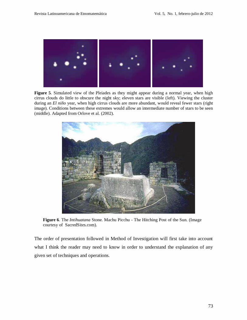
Figure 5. Simulated view of the Pleiades as they might appear during a normal year, when high cirrus clouds do little to obscure the night sky; eleven stars are visible (left). Viewing the cluster
during an El niño year, when high cirrus clouds are more abundant, would reveal fewer stars (right
image). Conditions between these extremes would allow an intermediate number of stars to be seen
(middle). Adapted from Orlove et al. (2002).
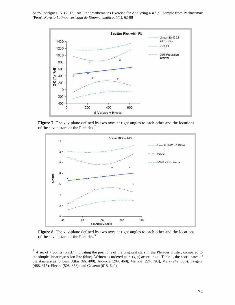
Figure 6. The Intihuatana Stone. Machu Picchu - The Hitching Post of the Sun. (Image courtesy of SacredSites.com).
The order of presentation followed in Method of Investigation will first take into account
what I think the reader may need to know in order to understand the explanation of any
given set of techniques and operations.
Saez-Rodríguez. A. (2012). An Ethnomathematics Exercise for Analyzing a Khipu Sample from Pachacamac
(Perú). Revista Latinoamericana de Etnomatemática. 5(1). 62-88
74
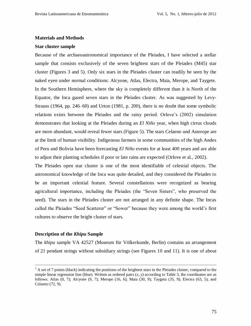
Figure 7. The x, y-plane defined by two axes at right angles to each other and the locations
of the seven stars of the Pleiades.2
Figure 8. The x, y-plane defined by two axes at right angles to each other and the locations of the seven stars of the Pleiades.
3
2 A set of 7 points (black) indicating the positions of the brightest stars in the Pleiades cluster, compared to
the simple linear regression line (blue). Written as ordered pairs (x, y) according to Table 1, the coordinates of
the stars are as follows: Atlas (66, 400); Alcyone (204, 468); Merope (224, 793); Maia (249, 336); Taygeta
(488, 315); Electra (508, 858); and Celaeno (618, 640).
Revista Latinoamericana de Etnomatemática Vol. 5, No. 1, febrero-julio de 2012
75
Materials and Methods
Star cluster sample
Because of the archaeoastronomical importance of the Pleiades, I have selected a stellar
sample that consists exclusively of the seven brightest stars of the Pleiades (M45) star
cluster (Figures 3 and 5). Only six stars in the Pleiades cluster can readily be seen by the
naked eyen under normal conditions: Alcyone, Atlas, Electra, Maia, Merope, and Taygete.
In the Southern Hemisphere, where the sky is completely different than it is North of the
Equator, the Inca gazed seven stars in the Pleiades cluster. As was suggested by Levy-
Strauss (1964, pp. 246–60) and Urton (1981, p. 200), there is no doubt that some symbolic
relations exists between the Pleiades and the rainy period. Orlove‟s (2002) simulation
demonstrates that looking at the Pleiades during an El Niño year, when high cirrus clouds
are more abundant, would reveal fewer stars (Figure 5). The stars Celaeno und Asterope are
at the limit of human visibility. Indigenous farmers in some communities of the high Andes
of Peru and Bolivia have been forecasting El Niño events for at least 400 years and are able
to adjust their planting schedules if poor or late rains are expected (Orlove et al., 2002).
The Pleiades open star cluster is one of the most identifiable of celestial objects. The
astronomical knowledge of the Inca was quite detailed, and they considered the Pleiades to
be an important celestial feature. Several constellations were recognized as bearing
agricultural importance, including the Pleiades (the “Seven Sisters”, who preserved the
seed). The stars in the Pleiades cluster are not arranged in any definite shape. The Incas
called the Pleiades “Seed Scatterer” or “Sower” because they were among the world‟s first
cultures to observe the bright cluster of stars.
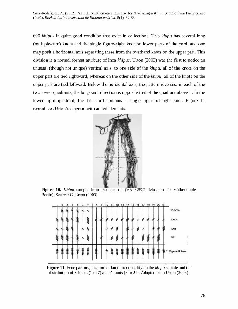
Description of the Khipu Sample
The khipu sample VA 42527 (Museum für Völkerkunde, Berlin) contains an arrangement
of 21 pendant strings without subsidiary strings (see Figures 10 and 11). It is one of about
3 A set of 7 points (black) indicating the positions of the brightest stars in the Pleiades cluster, compared to the
simple linear regression line (blue). Written as ordered pairs (x, y) according to Table 3, the coordinates are as
follows: Atlas (0, 7); Alcyone (9, 7); Merope (16, 6); Maia (30, 9); Taygeta (35, 9); Electra (63, 5); and
Celaeno (72, 9).
Saez-Rodríguez. A. (2012). An Ethnomathematics Exercise for Analyzing a Khipu Sample from Pachacamac
(Perú). Revista Latinoamericana de Etnomatemática. 5(1). 62-88
76
600 khipus in quite good condition that exist in collections. This khipu has several long
(multiple-turn) knots and the single figure-eight knot on lower parts of the cord, and one
may posit a horizontal axis separating these from the overhand knots on the upper part. This
division is a normal format attribute of Inca khipus. Urton (2003) was the first to notice an
unusual (though not unique) vertical axis: to one side of the khipu, all of the knots on the
upper part are tied rightward, whereas on the other side of the khipu, all of the knots on the
upper part are tied leftward. Below the horizontal axis, the pattern reverses: in each of the
two lower quadrants, the long-knot direction is opposite that of the quadrant above it. In the
lower right quadrant, the last cord contains a single figure-of-eight knot. Figure 11
reproduces Urton‟s diagram with added elements.
Figure 10. Khipu sample from Pachacamac (VA 42527, Museum für Völkerkunde,
Berlin). Source: G. Urton (2003).
Figure 11. Four-part organization of knot directionality on the khipu sample and the
distribution of S-knots (1 to 7) and Z-knots (8 to 21). Adapted from Urton (2003).
Revista Latinoamericana de Etnomatemática Vol. 5, No. 1, febrero-julio de 2012
77
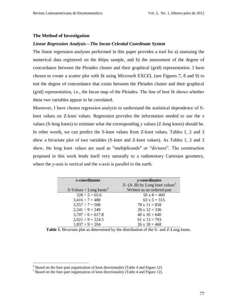
The Method of Investigation
Linear Regression Analysis—The Incan Celestial Coordinate System
The linear regression analyses performed in this paper provides a tool for a) assessing the
numerical data registered on the khipu sample, and b) the assessment of the degree of
concordance between the Pleiades cluster and their graphical (grid) representation. I have
chosen to create a scatter plot with fit using Microsoft EXCEL (see Figures 7, 8 and 9) to
test the degree of concordance that exists between the Pleiades cluster and their graphical
(grid) representation, i.e., the Incan map of the Pleiades. The line of best fit shows whether
these two variables appear to be correlated.
Moreover, I have chosen regression analysis to understand the statistical dependence of S-
knot values on Z-knot values. Regression provides the information needed to use the x
values (S-long knots) to estimate what the corresponding y values (Z-long knots) should be.
In other words, we can predict the S-knot values from Z-knot values. Tables 1, 2 and 3
show a bivariate plot of two variables (S-knot and Z-knot values). As Tables 1, 2 and 3
show, the long knot values are used as "multiplicands" or “divisors”. The construction
proposed in this work lends itself very naturally to a rudimentary Cartesian geometry,
where the y-axis is vertical and the x-axis is parallel to the earth.
x-coordinates
S-Values ÷ Long knots
4
y-coordinates
Z- (A–B) by Long knot values5
Written as an ordered pair
328 ÷ 5 = 65.6 50 x 8 = 400
3,416 ÷ 7 = 488 63 x 5 = 315 3,557 ÷ 7 = 508 78 x 11 = 858
2,241 ÷ 9 = 249 28 x 12 = 336
3,707 ÷ 6 = 617.8 40 x 16 = 640
2,021 ÷ 9 = 224.5 61 x 13 = 793 1,837 ÷ 9 = 204 26 x 18 = 468
Table 1. Bivariate plot as determined by the distribution of the S- and Z-Long knots.
4 Based on the four-part organization of knot directionality (Table 4 and Figure 12) 5 Based on the four-part organization of knot directionality (Table 4 and Figure 12).
Saez-Rodríguez. A. (2012). An Ethnomathematics Exercise for Analyzing a Khipu Sample from Pachacamac
(Perú). Revista Latinoamericana de Etnomatemática. 5(1). 62-88
78
Z-Long knot values
Written as an ordered pair
(A + B)
x-coordinates
Z-(A+B) times S-Long
Knots6
y-coordinates
S-Long knot
values
Displayed in
inverted order
7 + 1 = 8 9 x 8 = 72 5 9
0 + 5 = 5 9 x 5 = 45 7 9
2 + 9 = 11 6 x 11 = 66 7 6 7 + 5 = 12 9 x 12 = 108 9 9
8 + 8 = 16 7 x 16 = 112 6 7
6 + 7 = 13 7 x 13 = 91 9 7
9 + 9 = 18 5 x 18 = 90 9 5
Table 2. Bivariate plot as determined by the distribution of the S- and Z-Long knots.
x-coordinates
Z- (AxB) Crossed strings7
Written as an ordered pair
y-coordinates
S-Long knot values
7 x 9 = 63 5
1 x 9 = 9 7
0 x 7 = 0 7
5 x 6 = 30 9 2 x 8 = 16 6
9 x 8 = 72 9
7 x 5 = 35 9
Table 3. Bivariate plot as determined by the distribution of the S- and Z-Long knots.
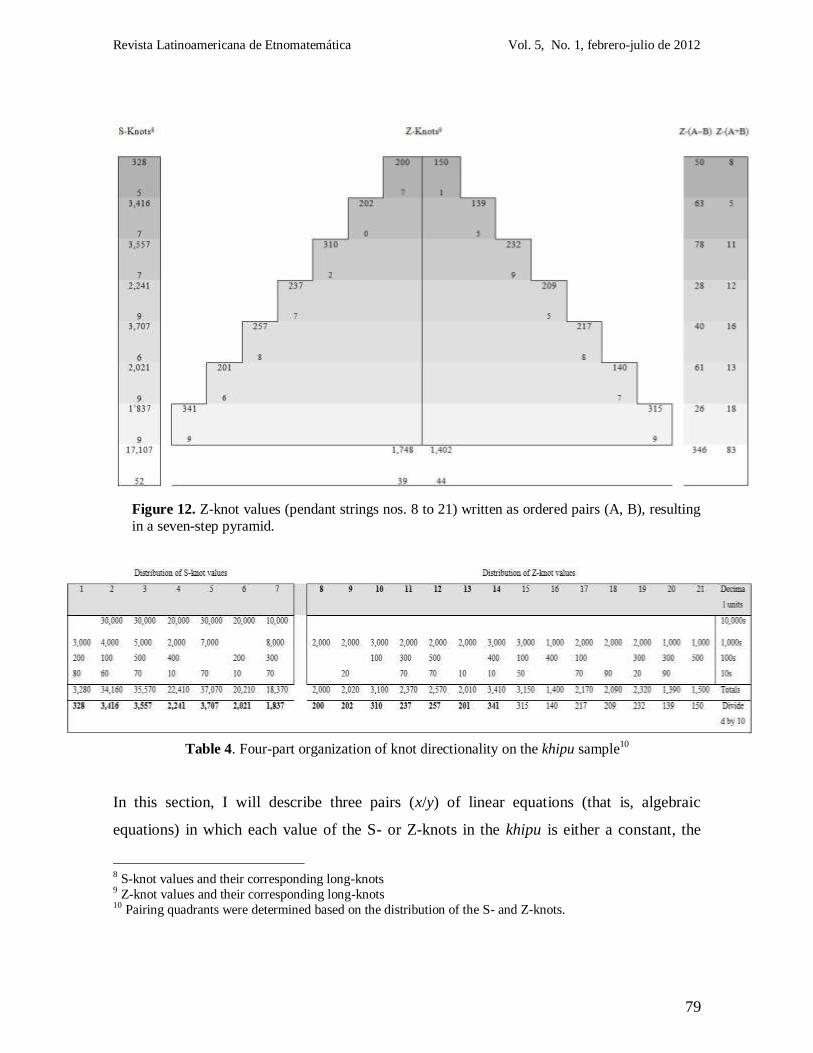
In this particular sample (see Table 4 and Figure 12), I observed that half of the values on
the 14 pendant strings (nos. 8 to 14 in the upper right quadrant) were higher than the
remaining values (nos. 15 to 21). As Figure 12 shows, we can thus arrange pairs of pendant
strings (A and B) such that pendant string B represents a smaller (or equivalent) quantity
than its partner (pendant string A). Pendant string A should therefore indicate values greater
than or equal to those in pendant string B (A ≥ B). Figure 12 thus indicates the existence of
a preferential pairing assortment of strings. More careful observation revealed the knot
maker/keeper apparently developed a more efficient rationale for arranging pendant strings
in pairs, pairing the first pendant string with the last pendant string, the second with the
next to last, and so.
6 According to the Four-part organization of knot directionality (Table 4 and Figure 12) 7 Based on the four-part organization of knot directionality (Table 4 and Figure 12).
Revista Latinoamericana de Etnomatemática Vol. 5, No. 1, febrero-julio de 2012
79
Figure 12. Z-knot values (pendant strings nos. 8 to 21) written as ordered pairs (A, B), resulting
in a seven-step pyramid.89
Table 4. Four-part organization of knot directionality on the khipu sample10
In this section, I will describe three pairs (x/y) of linear equations (that is, algebraic
equations) in which each value of the S- or Z-knots in the khipu is either a constant, the
8 S-knot values and their corresponding long-knots 9 Z-knot values and their corresponding long-knots 10 Pairing quadrants were determined based on the distribution of the S- and Z-knots.
Saez-Rodríguez. A. (2012). An Ethnomathematics Exercise for Analyzing a Khipu Sample from Pachacamac
(Perú). Revista Latinoamericana de Etnomatemática. 5(1). 62-88
80
product/quotient, or the addition/subtraction of a constant and (the first power of) a single
variable.
A common form for the linear equation in the two variables x and y is y mx b , where
m and b designate constants. Suppose we have n points (xi; yi) with distinct x-coordinates;
for example, if n = 7 we have the points 7 71 1, );...; , )( (y yx x .
The Incan altitude-azimuth coordinate system
Altitude is the angular distance of a star above the local horizon. Azimuth is the angular
distance of a star object from the local (North), measured along the horizon. Reinhard
(2002) has written of the importance to the Inca of cardinal directions.
How did the Incas calculate the azimuth and the altitude of an object?
As far as is known, the astronomical instruments and devices of the Incas were of the
simplest character. To calculate the approximate altitude (e.g., pata means „above‟ in
Quechua, orqopata = above the mountain) and azimuth for a star, the Incas needed to
estimate those angular distances. The Incas also needed to keep in mind that since stars
change their position with respect to horizon throughout the night, their altitude-azimuth
position changes, as this system was based on the observer. The second way of specifying
star positions is the equatorial coordinate system. This system is fixed with respect to the
stars so, unlike the altitude-azimuth system, a star's position does not depend on the
observer's location or time. Because of this, the Incas may have preferred using this system.
After analyzing the values in the pairing quadrants, I have recognized the following three
different pairs of equations (x, y), resulting in three distinct types of stellar configuration
(i.e., star maps), which are very similar to the configuration of the brightest stars in the
Pleiades cluster.
Revista Latinoamericana de Etnomatemática Vol. 5, No. 1, febrero-julio de 2012
81
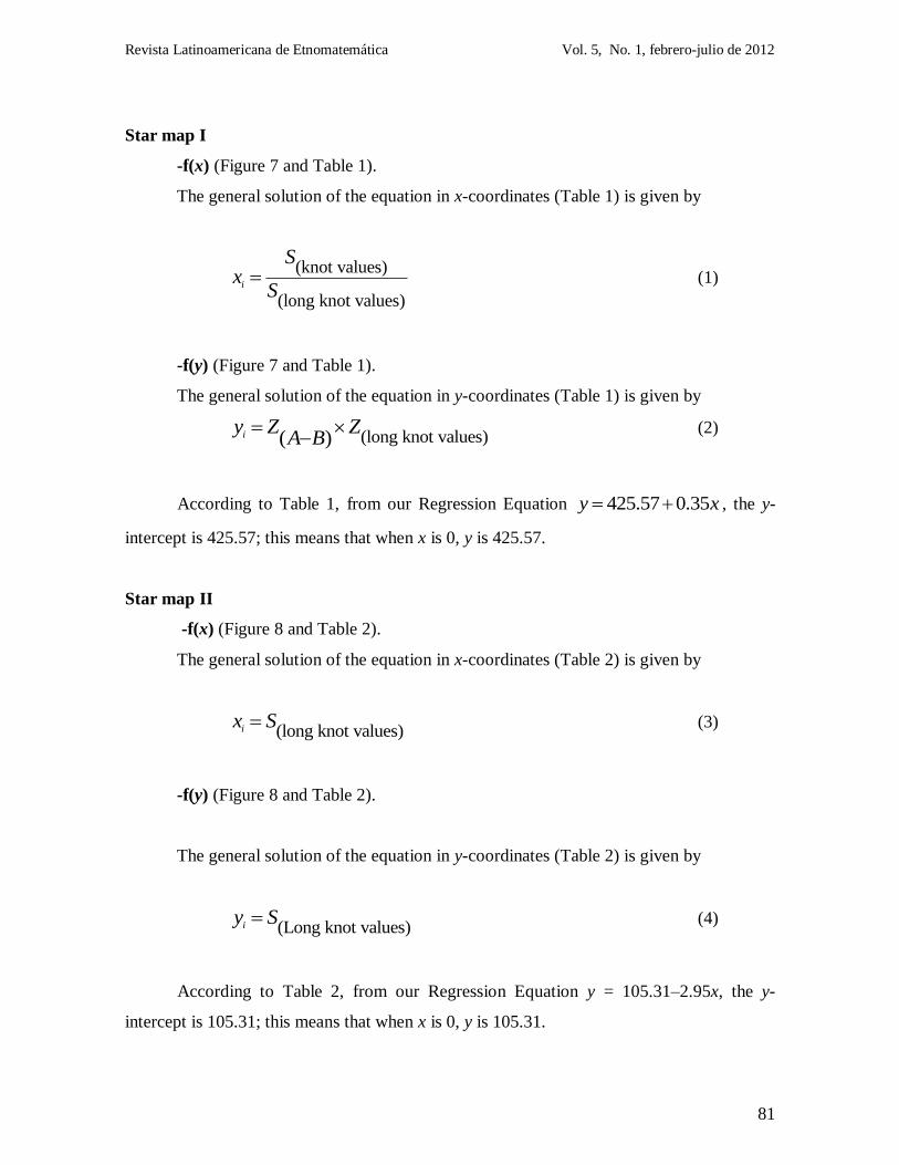
Star map I
-f(x) (Figure 7 and Table 1).
The general solution of the equation in x-coordinates (Table 1) is given by
(knot values)
(long knot values)i
Sx
S (1)
-f(y) (Figure 7 and Table 1).
The general solution of the equation in y-coordinates (Table 1) is given by
(long knot values)( )iy Z ZA B
(2)
According to Table 1, from our Regression Equation 425.57 0.35y x , the y-
intercept is 425.57; this means that when x is 0, y is 425.57.
Star map II
-f(x) (Figure 8 and Table 2).
The general solution of the equation in x-coordinates (Table 2) is given by
(long knot values)ix S (3)
-f(y) (Figure 8 and Table 2).
The general solution of the equation in y-coordinates (Table 2) is given by
(Long knot values)iy S (4)
According to Table 2, from our Regression Equation y = 105.31–2.95x, the y-
intercept is 105.31; this means that when x is 0, y is 105.31.
Saez-Rodríguez. A. (2012). An Ethnomathematics Exercise for Analyzing a Khipu Sample from Pachacamac
(Perú). Revista Latinoamericana de Etnomatemática. 5(1). 62-88
82
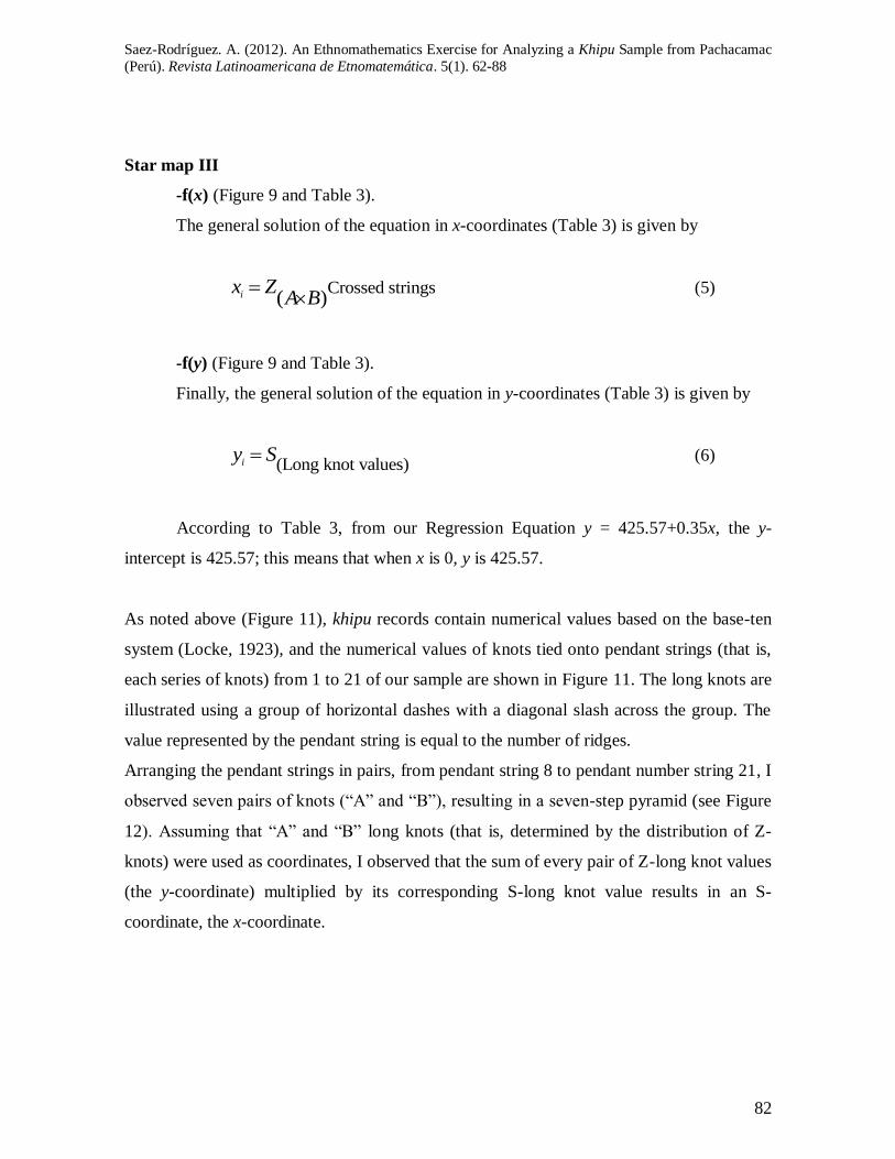
Star map III
-f(x) (Figure 9 and Table 3).
The general solution of the equation in x-coordinates (Table 3) is given by
Crossed strings( )ix ZA B
(5)
-f(y) (Figure 9 and Table 3).
Finally, the general solution of the equation in y-coordinates (Table 3) is given by
(Long knot values)iy S (6)
According to Table 3, from our Regression Equation y = 425.57+0.35x, the y-
intercept is 425.57; this means that when x is 0, y is 425.57.
As noted above (Figure 11), khipu records contain numerical values based on the base-ten
system (Locke, 1923), and the numerical values of knots tied onto pendant strings (that is,
each series of knots) from 1 to 21 of our sample are shown in Figure 11. The long knots are
illustrated using a group of horizontal dashes with a diagonal slash across the group. The
value represented by the pendant string is equal to the number of ridges.
Arranging the pendant strings in pairs, from pendant string 8 to pendant number string 21, I
observed seven pairs of knots (“A” and “B”), resulting in a seven-step pyramid (see Figure
12). Assuming that “A” and “B” long knots (that is, determined by the distribution of Z-
knots) were used as coordinates, I observed that the sum of every pair of Z-long knot values
(the y-coordinate) multiplied by its corresponding S-long knot value results in an S-
coordinate, the x-coordinate.
Revista Latinoamericana de Etnomatemática Vol. 5, No. 1, febrero-julio de 2012
83
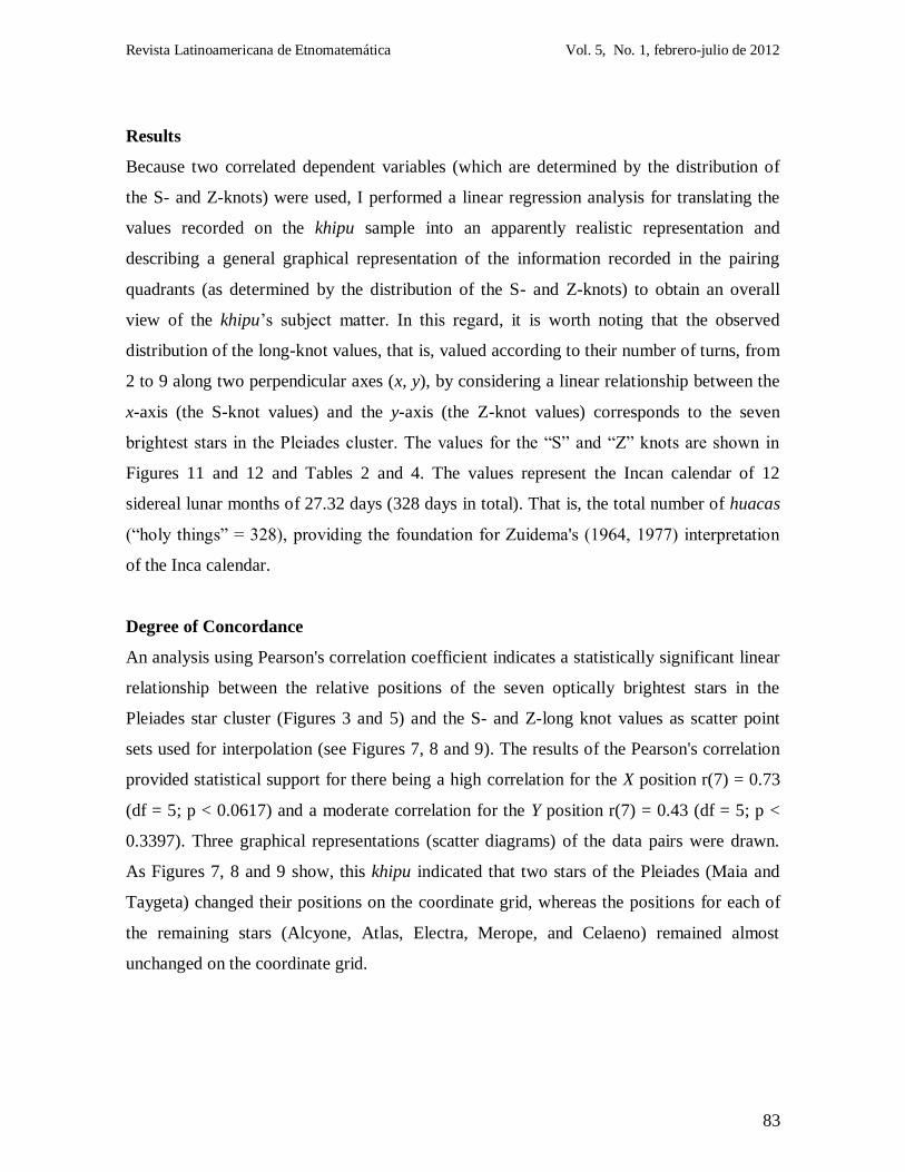
Results
Because two correlated dependent variables (which are determined by the distribution of
the S- and Z-knots) were used, I performed a linear regression analysis for translating the
values recorded on the khipu sample into an apparently realistic representation and
describing a general graphical representation of the information recorded in the pairing
quadrants (as determined by the distribution of the S- and Z-knots) to obtain an overall
view of the khipu‟s subject matter. In this regard, it is worth noting that the observed
distribution of the long-knot values, that is, valued according to their number of turns, from
2 to 9 along two perpendicular axes (x, y), by considering a linear relationship between the
x-axis (the S-knot values) and the y-axis (the Z-knot values) corresponds to the seven
brightest stars in the Pleiades cluster. The values for the “S” and “Z” knots are shown in
Figures 11 and 12 and Tables 2 and 4. The values represent the Incan calendar of 12
sidereal lunar months of 27.32 days (328 days in total). That is, the total number of huacas
(“holy things” = 328), providing the foundation for Zuidema's (1964, 1977) interpretation
of the Inca calendar.
Degree of Concordance
An analysis using Pearson's correlation coefficient indicates a statistically significant linear
relationship between the relative positions of the seven optically brightest stars in the
Pleiades star cluster (Figures 3 and 5) and the S- and Z-long knot values as scatter point
sets used for interpolation (see Figures 7, 8 and 9). The results of the Pearson's correlation
provided statistical support for there being a high correlation for the X position r(7) = 0.73
(df = 5; p < 0.0617) and a moderate correlation for the Y position r(7) = 0.43 (df = 5; p <
0.3397). Three graphical representations (scatter diagrams) of the data pairs were drawn.
As Figures 7, 8 and 9 show, this khipu indicated that two stars of the Pleiades (Maia and
Taygeta) changed their positions on the coordinate grid, whereas the positions for each of
the remaining stars (Alcyone, Atlas, Electra, Merope, and Celaeno) remained almost
unchanged on the coordinate grid.
Saez-Rodríguez. A. (2012). An Ethnomathematics Exercise for Analyzing a Khipu Sample from Pachacamac
(Perú). Revista Latinoamericana de Etnomatemática. 5(1). 62-88
84
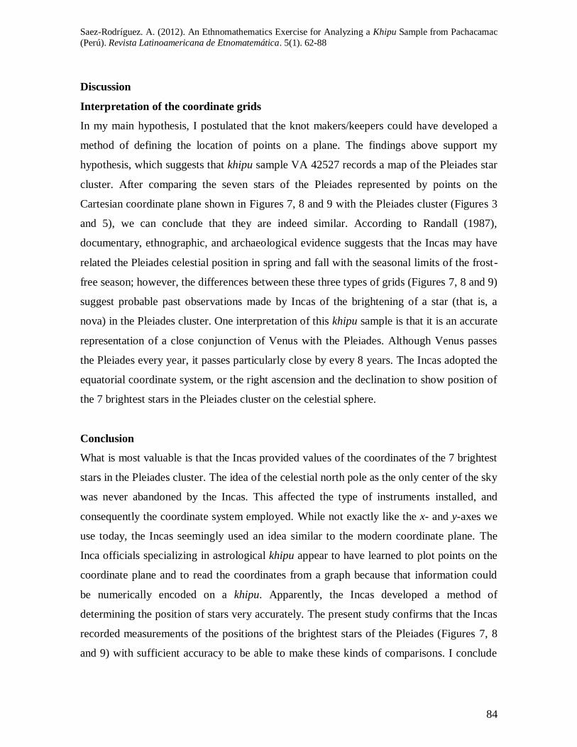
Discussion
Interpretation of the coordinate grids
In my main hypothesis, I postulated that the knot makers/keepers could have developed a
method of defining the location of points on a plane. The findings above support my
hypothesis, which suggests that khipu sample VA 42527 records a map of the Pleiades star
cluster. After comparing the seven stars of the Pleiades represented by points on the
Cartesian coordinate plane shown in Figures 7, 8 and 9 with the Pleiades cluster (Figures 3
and 5), we can conclude that they are indeed similar. According to Randall (1987),
documentary, ethnographic, and archaeological evidence suggests that the Incas may have
related the Pleiades celestial position in spring and fall with the seasonal limits of the frost-
free season; however, the differences between these three types of grids (Figures 7, 8 and 9)
suggest probable past observations made by Incas of the brightening of a star (that is, a
nova) in the Pleiades cluster. One interpretation of this khipu sample is that it is an accurate
representation of a close conjunction of Venus with the Pleiades. Although Venus passes
the Pleiades every year, it passes particularly close by every 8 years. The Incas adopted the
equatorial coordinate system, or the right ascension and the declination to show position of
the 7 brightest stars in the Pleiades cluster on the celestial sphere.
Conclusion
What is most valuable is that the Incas provided values of the coordinates of the 7 brightest
stars in the Pleiades cluster. The idea of the celestial north pole as the only center of the sky
was never abandoned by the Incas. This affected the type of instruments installed, and
consequently the coordinate system employed. While not exactly like the x- and y-axes we
use today, the Incas seemingly used an idea similar to the modern coordinate plane. The
Inca officials specializing in astrological khipu appear to have learned to plot points on the
coordinate plane and to read the coordinates from a graph because that information could
be numerically encoded on a khipu. Apparently, the Incas developed a method of
determining the position of stars very accurately. The present study confirms that the Incas
recorded measurements of the positions of the brightest stars of the Pleiades (Figures 7, 8
and 9) with sufficient accuracy to be able to make these kinds of comparisons. I conclude
Revista Latinoamericana de Etnomatemática Vol. 5, No. 1, febrero-julio de 2012
85
from these results that the Inca astronomers developed a novel coordinate plane in which
the seven stars of the Pleiades could be described.
Although there is no other confirmatory evidence from other works that knot
makers/keepers invoked plots of the Pleiades star cluster, this apparently inconsequential
detail has developed into a key theme, that the Incas developed a celestial coordinate
system. It is clear that the knot makers/keepers introduced the novel idea of specifying the
position of a point or object on a surface using two intersecting axes as measuring guides.
Like the Mayas, the adoption of the equatorial coordinate system was a unique contribution
of the Incas to pre-Columbian astronomy, as ancient astronomers all used the ecliptic
coordinate system to mark the position of fixed stars. Based on their own observations (see
Figures 7, 8 and 9), the Incas deduced that the stars were constantly changing their position
in the celestial sphere. The Inca thus became the first astronomers in the pre-Columbian
America to study the movement of stars, about 200 years before English astronomer
Edmund Halley (1656–1742). The Incan celestial coordinate system was, thus, an old
coordinate system for mapping positions on the celestial sphere. I can conclude that the
organization of information according to knot directionality, that is to say, the variability in
the construction of knots resulting in Z- and S-knots, is an important element of the khipu
information system.
It seems likely that at the time of the Spanish Conquest some astronomical knowledge of
the Incas had either been lost by the Spanish chronicles, or more likely they had simply
deliberately withheld important astronomical knowledge from the Inquisitors. It is
important to remember that Galileo‟s book, Dialogue Concerning the Two Chief World
Systems, was published in 1632, with formal authorization from the Inquisition and papal
permission (Pope Paul V), exactly 100 years after the Spanish conquest of the Inca Empire
(1532).
References
Avila, F. de. (1966). Dioses y hombres de Huarochiri. Lima: Siglo Veintiuno.
Bell, E. T. (1945). Development of Mathematics. New York: McGraw-Hill Book Company
Saez-Rodríguez. A. (2012). An Ethnomathematics Exercise for Analyzing a Khipu Sample from Pachacamac
(Perú). Revista Latinoamericana de Etnomatemática. 5(1). 62-88
86
Cobo, B. (1956). Historia del Nuevo Mundo. In BIBL. AUT. ESP. Tomi XCI, XCII,
Madrid
_________. (1990). Inca religion and customs. Austin: University of Texas Press.
D'Ambrosio, U. (1997). Foreword. En A. Powell, & M. Frankenstein (Edits.),
Ethnomathematics: Challenging Eurocentrism in Mathematics Education (págs. xv-xxi).
Albany, EE.UU: State University of New York.
Dean, C. (2001). Andean Androgyny and the Making of Man. University of California,
Santa Cruz. C. F. Klein & J. Quilter (Eds). In Gender in Pre-Hispanic America. Dumbarton
Oaks Trustees for Harvard University Washington. Washington, D.C: Dumbarton Oaks
Research Library and Collection
Delambre, J. B. J. (1817). Histoire de l'astronomie ancienne, Paris: Ve Courcier.
Durán, J. G. (1982). El Catecismo del III Concilio Provincial de Lima y sus complementos
pastorales (1584-1585): Estudio preliminar, textos, notas. Buenos Aires: Facultad de
Teolog a de la Pontificia Universidad Católica Argentina "Santa Mar a de los Buenos
Aires".
Garcilaso de la Vega. (1966). Royal commentaries of the Inkas. Austin: University of Texas
Press.
Gartner W.G. (1998). Mapmaking in the Centrakl Andes. In David Woodward & G.
Malcolm Lewis (Eds) The History of Cartography, Volume 2, Book 3: Cartography in the
Traditional African, American, Arctic, Australian, and Pacific Societies. University of
Chicago Press.
González Holguín, D. (1952). Vocabulario de la lengua general de todo el Perú, llamado
lengua quichua o del Inca. Lima: Universidad Nacional Mayor de San Marcos.
Guaman Poma de Ayala, F. (1980). El Primer Nueva Crónica y Buen Gobierno, editado por
J. Murra, R. Adorno y J. Urioste. México: Editorial Siglo Veintiuno.
Hiltunen, J. (2003). Separating Invention from Possible Inherited Traditions in the
Chronicle of Montesinos. In Andean History from Non-Cuzco-Centric Sources, University
of Oulu, Finland. Recuperado de http://www.traditionalhighcultures.org/HiltunenPaper.htm
Julien, C. J. (2000). Reading Inca History. Iowa City: University of Iowa Press.
Krupp, E. C. (2003). Echoes of the Ancient Skies: The Astronomy of Lost Civilizations.
Astronomy Series. New york: Dover Publications.
Revista Latinoamericana de Etnomatemática Vol. 5, No. 1, febrero-julio de 2012
87
Lévi-Strauss, C. (1964). Mythologiques: le cru et le cuit. Paris: Plon.
Locke, L. L. (1923). The ancient Quipu or Peruvian Knot Record. New York: American
Museum of Natural History.
Montesinos, F. (1920). Memorias Antiguas Historiales y Politicas del Perú. London:
Hakluyt Society.
Orey, D. C. (2000). The ethnomathematics of the Sioux tipi and cone. In H. Selin (Ed.),
Mathematics across culture: the History of non-Western mathematics. Dordrecht,
Netherlands: Kluwer Academic Publishers.
Orlove, B., J. C.; H. Chiang & M. A. Cane. (2002). Ethnoclimatology in the Andes: a cross
disciplinary study uncovers a scientific basis for the scheme Andean potato farmers
traditionally use to predict the coming rains. American Scientist. Vol. 90. p. 428-435.
Ptolemy, K. F. A. N. (1843). Claudii Ptolemaei geographia. Editorial Sumptibus et typis
Caroli Tauchnitii
Randall, R. (1987). Return of the Pleiades. Natural History, 96 (6), p. 42–53.
Reinhard, J. (2002). Machu Picchu, The Sacred Center. Cusco: Instituto Machu Picchu.
Rowe, J. (1999). Estandarización de las Túnicas de Tapiz Inca, In: Lavalle, J. & Lavalle,
R. Tejidos Milenarios del Perú. (p. 571-627), Lima: AFP Integra.
Talbot, C. R. M. (2007). Sir Isaac Newton's Enumeration of Lines of the Third Order.
Merchant Books.
Santa Cruz, J. de. (1968). Relación de antigüedades deste reyno del Pirú : gramática y
discurso ideológico indígena. Madrid: Ediciones Atlas.
Silverblatt, I. M. (1987). Moon, sun, and witches: gender ideologies and class in Inca and
colonial Peru. Nueva Jersey: Princeton University Press.
Steele, P. R. & C. J. Allen. (2004). Handbook of Inca mythology. Santa Barbara, California:
ABC-CLIO
Urton, G. (1981). At the Crossroads of the Earth and the Sky: An Andean Cosmology.
Austin: University of Texas Press.
_________. (2003). Signs of the Inka Khipu. Binary Coding in the Andean Knotted-String
records. Austin: University of Texas Press.
Saez-Rodríguez. A. (2012). An Ethnomathematics Exercise for Analyzing a Khipu Sample from Pachacamac
(Perú). Revista Latinoamericana de Etnomatemática. 5(1). 62-88
88
Zuidema, R. T. (1964). The Ceque System of Cuzco: The Social Organization of the
Capital of the Incas. International Archives of Ethnography, suplemento al vol. 50.
_________. (1977). The Inca Calendar. In: Native American Astronomy. Austin:
University of Texas Press.
_________. (1982). Catachillay: The Role of the Pleiades and of the Southern Cross and
Centauri in the Calendar of the Inkas. In Aveni, A., Avensand, A. & Urton G. (eds.),
Ethnoastronomy and Archaeoastronomy in the American Tropics., New York: New York
Academy of Sciences.
_________. (2004). El Quipu Dibujado Calendárico Llamado Pachaquipu en el
Documento Exsul Immeritus de la Colección Miccinelli. In El silencio protagonista: el
primer siglo jesuita en el Virreinato del Perú, 1567 - 1667; actas del Simposio Hist-11. "El
Primer Siglo jesuita en el Virreinato del Perú", 51. Congreso Internacional de
Americanistas, Santiago de Chile, 17 - 18 de julio, 2003. Quito: Abya Yala.