Embed Size (px)
Citation preview
Sains Malaysiana 36(2)(2007): 159-163
An Integrated Geophysical Study of the Quaternary Basin atOlak Lempit – Banting Area, Selangor, Malaysia
(Kajian Geofizik Bersepadu Lembangan Kuaterneri di KawasanOlak Lempit – Banting, Selangor, Malaysia)
ABDUL RAHIM SAMSUDIN, UMAR HAMZAH & ZURAIDAH RAMLI
ABSTRACT
An integrated geophysical study was conducted to investigate the subsurface regional structure and the presence of aQuaternary sedimentary basin in the Olak Lempit - Banting area of Selangor, Malaysia. A regional gravity survey andthe high resolution reflection seismic were employed to determine the thickness and areal distribution of the alluvialsedimentary basin as well as to investigate the depth and topography of the bedrock in the study area. The sedimentarybasin hosts one of the most important coastal alluvial aquifer which was used to cater the shortage of domestic watersupply during the worst water crisis that hit the state of Selangor in 1998. The surface geological map shows that ingeneral 70% of the study area is covered by Quaternary deposits of Beruas, Gula and Simpang Formations whichoverlie the sedimentary bedrock of Kenny Hill Formation. The Beruas Formation consists of mainly clay, sandy clay andpeat of Holocene fluviatile-estuarine deposits, whereas the Gula Formation represents Holocene marine to estuarinesediments which mostly consists of clay and minor sand. The Simpang Formation (Pleistocene) is a continental depositcomprising of gravel, sand, clay and silt. The underlying Kenny Hill Formation consists of a monotonous sequence ofinterbedded shales, mudstones and sandstones. The rock is Carbonaceous in age and it forms an undulating surfacetopography in the eastern part of the study area. A total of 121 gravity stations were established using a La Coste &Romberg gravity meter and the elevations of most of the stations were determined barometrically using Tiernan-Wallacealtimeters. The high resolution seismic reflection using the common mid point (CMP) or roll along technique was carriedout using a 24 channel signal enhancement seismograph and high frequency geophones. A total length of about 1.7 kmstacked seismic section has been acquired in this survey and a nearby borehole data was used for interpretation. Arelative Bouguer anomaly map shows an elongated zone of low gravity anomaly trending approximately NW-SE which isinterpreted to be the deposition center of the Quaternary basin. The interpreted gravity profiles running across thecentral area of the study area show that the basin has thickness varies from tenth to several hundred meters with maximumdepth to bedrock of about 275 m. A gravity profile which passes through the eastern edge of the basin was modeled withdepth to bedrock of about 178 m below ground which agrees very well with those obtained from the interpreted seicmicsection and borehole data. The stacked seismic section shows several high amplitude parallel to sub-parallel reflectionoverlying discontinuos and low reflection pattern. Reflections on the eastern part of the section is much shallower thanthe one observed on the western part which clearly indicates the presence of basinal structure with a total interpreteddepth to bedrock of about 200 meters.
Keywords: Quaternary basin; seismic section; gravity modeling; subsurface structure
ABSTRAK
Penyiasatan geofizik bersepadu telah dijalankan untuk mengkaji struktur rantau bawah permukaan dan kewujudanlembangan sedimen Kuaterneri di kawasan Olak Lempit – Banting Selangor, Malaysia. Survei graviti rantau dan seismospantulan beresolusi tinggi telah digunakan untuk menentukan ketebalan dan keluasan lembangan sedimen aluviumserta mengkaji kedalaman dan topografi batuan dasar di kawasan kajian. Lembangan sedimen ini merupakan akuiferaluvium pantai penting yang digunakan untuk menampung bekalan air semasa berlakunya krisis air terburuk di negeriSelangor pada tahun 1998. Peta geologi menunjukkan kawasan kajian terdiri daripada 70% endapan aluvium kuaterneridaripada Formasi Beruas, Gula dan Simpang yang menindih batuan sedimen Formasi Kenny Hill. Formasi Beruas inikebanyakannya merupakan lempung, lempung berpasir dan gambut daripada sedimen fluviatil-estuarin yang berusiaHolosen, manakala Formasi Gula pula merupakan sedimen marin-estuarin yang kebanyakannya terdiri daripada lempungdan sedikit pasir. Formasi Simpang pula (berusia Pleistosen) merupakan endapan benua yang terdiri daripada gravel,pasir, lempung dan lodak. Batuan dasar Formasi Kenny Hill terbentuk daripada selang lapis batu syal, batu lumpur andbatu pasir. Batuan ini berusia Karbon dan membentuk topografi bawah permukaan beralun di bahagian timur kawasankajian. Sebanyak 121 stesen graviti telah diukur menggunakan meter graviti La Coste & Romberg dan ketinggiankebanyakan stesen ditentukan dengan menggunakan barometer Tiernan-Wallace. Survei seismos pantulan beresolusi
160
tinggi menggunakan kaedah titik tengah sepunya (CMP) atau kaedah anjakan kesisi telah dilakukan dengan menggunakanseismograf peningkatan isyarat 24 saluran dan geofon berfrekuensi tinggi. Sepanjang 1.7 km keratan seismos telahdiperolehi dalam survei ini dan data lubang gerudi yang berhampiran telah digunakan untuk pentafsiran. Peta bougueranomali relatif menunjukkan zon anomali graviti rendah yang membujur dengan arah kurang lebih baratlaut-tenggarayang ditafsirkan sebagai pusat pengendapan sedimen lembangan Kuarterner. Pentafsiran profil graviti yang memotongbahagian tengah kawasan kajian menunjukkan ketebalan sedimen berubah daripada puluhan ke ratusan meter tebaldengan kedalaman maksimum batuan dasar sekitar 275m. Profil graviti yang melalui bahagian tepi timur lembangantelah dimodelkan dengan kedalaman sekitar 178m dan sesuai dengan hasil tafsiran yang diperolehi daripada keratanseismos dan lubang gerudi. Keratan seismos timbunan menunjukkan ciri pantulan selari dan sub-selari berfrekuensitinggi menindeh corak pantulan berfrekuensi rendah yang tidak kontinu. Pantulan di sebelah timur kelihatan lebih cetekberbanding pantulan disebelah barat kawasan kajian yang jelas menunjukkan kewujudan struktur lembangan dengankedalaman tafsiran batuan dasar sekitar 200 meter.
Kata kunci: Lembangan Kuarterneri; keratan seismos; permodelan graviti; struktur bawah permukaan
uppermost layer is Beruas Formation which mainlyconsists of clay, sandy clay and peat of Holocene fluviatile-estuarine deposits (Azhar Hussin 2001). The presence oforganic materials in the formation and the subsequentdecaying cause the discoloration of water and acidity ofthe surface and upper aquifer.
The underlying Gula Formation represents Holocenemarine to estuarine sediments which mostly consists ofclay and minor sand. The lower most alluvium unit isSimpang Formation. It consists of terrestrial Pleistocenedeposit comprising of gravel, sand, clay and silt overlyingthe Kenny Hill Formation bedrock. The coarse to verycoarse sand and gravel as the main component occurred atthe base of the formation (Loh 1992).
The Kenny Hill formation consists of a monotonoussequence of interbedded shales, mudstones and sandstones.The rock is Carbonaceous in age and it forms an undulatingsurface topography in the eastern part of the study area.
GRAVITY SURVEY
The gravity measurements were conducted along theavailable roads with a La Coste Romberg model G467gravity meter. The gravity station interval is about 1 to 2kilometers. The stations were located at position easilyidentifiable on the topographic maps, such as roadjunctions, bench marks and stream crossings. Theelevations of the stations were determined using altimetersand the single base system. Two sets each comprising twoWellace and Tiernan altimeters were used, one set locatedat a base station (BM 0955), and the other set used for thefield measurements at each gravity station (Zuraida Ramli2001). In order to reduce error in the height determination,where possible, stations were located at points of knownheight, such as benchmarks and sea level. The error in theelevation was 2 to 3 meters for the altimeter readings.
To ensure that the gravity data obtained are of highquality, stringent field procedures as described by Butleret al. (1983) were observed. The selected base station wasused to monitor and correct the drift of the equipment.Bench marks wherever available were used as controlstations in order to minimise the error of the elevationsmeasured.
INTRODUCTION
An integrated geophysical study was conducted toinvestigate the subsurface regional structure and thepresence of a Quaternary sedimentary basin in the OlakLempit - Banting area of Selangor, Malaysia. The basinhosts one of the most important coastal alluvial aquiferwhich was used to cater for the domestic water supplyduring the worst water crisis that hit the state of Selangorin 1998. Mineral and Geoscience department of Malaysiawas specifically directed to explore the possibility ofgroundwater exploitation in the study area which at thetime was extracted ground water on a relatively small scaleat Megasteel complex which produced about 10,500m3/day (Geological Survey Department 1998). The departmenthad constructed several paired boreholes in various siteswithin the area. The shallow boreholes tapped water fromthe upper 25 m layer of mostly clay while the deeperboreholes tapped water below the 25 m depth which arefrom the sandy and gravel layer ( Md. Shahid Ayub 2001).
Previous regional gravity measurements have beenmade in this area by the department of Mineral andGeoscience Malaysia. The principal difference in thepresent survey is in the attempt to obtain a uniform arealcoverage representing an average station spacing of about1.5 to 2 km. Other geophysical surveys i.e. 2-D resistivityimaging and resistivity sounding as well as seismicrefraction have also been conducted in this area by Nawawiet al. (2001), Ibrahim et al.(2001), Ibrahim et al. (2003a),Ibrahim et al. (2003b) and Wong (2000) respectively. Theworks however did not cover the whole study area anddepth of bedrock was not clearly established.
This paper describes results of a regional gravitysurvey and the high resolution seismic profiling which wereemployed to study the thickness and areal distribution ofthe alluvial sedimentary basin as well as to investigate thedepth and topography of the bedrock in the study area.
GEOLOGY
The geological map of the study area shows that in general70% of the area is covered by the Quaternary deposits ofBeruas, Gula and Simpang Formations which overlie thesedimentary bedrock of Kenny Hill Formation. The
161
All together about 121 gravity stations were obtained.Drift, latitude, free-air and Bouguer corrections wereapplied to the gravity readings. Terrain correction was notapplied since the topography of the area is generally flat.An average density of 1.8 g cm-3 was used for the Bouguercorrection. This density was chosen to represent thealluvium.
The relative Bouguer gravity anomalies along thetraverses were projected onto several profiles for modelingpurposes. Two-dimensional subsurface geological modelsfor the profiles were obtained using a commerciallyavailable 2-D gravity program (Magix Plus). The gravityanomalies give information on density variations withinthe earth. It is well known that an infinite (but bounded)number of mass distributions can give rise to the sameobserved anomaly. Thus the models are non-unique. Thisambiguity however can be resolved by conducting othergeophysical techniques such as deep reflection seismic aswell as by correlation with subsurface geologicalinformation from available boreholes.
SEISMIC REFLECTION SURVEY
For this present study, a high resolution seismic reflectionsurvey using the common mid point (CMP) or roll alongtechnique was carried out (Umar Hamzah et. al. 2000). A24-channel signal enhancement seismograph (Abem MarkIII) with high frequency geophones were used in the survey.Emulex 150 explosives with electric detonators were usedfor generating seismic source. The offset shot during the
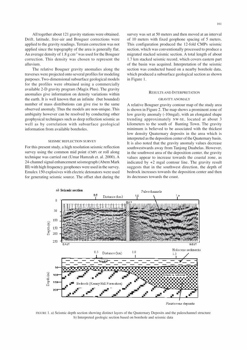
survey was set at 50 meters and then moved at an intervalof 10 meters with fixed geophone spacing of 5 meters.This configuration produced the 12-fold CMPs seismicsection, which was conventionally processed to produce amigrated stacked seismic section. A total length of about1.7 km stacked seismic record, which covers eastern partof the basin was acquired. Interpretation of the seismicsection was conducted based on a nearby borehole data,which produced a subsurface geological section as shownin Figure 1.
RESULTS AND INTERPRETATION
GRAVITY ANOMALY
A relative Bouguer gravity contour map of the study areais shown in Figure 2. The map shows a prominent zone oflow gravity anomaly (-10mgal), with an elongated shapetrending approximately NW-SE, located at about 3kilometers to the south of Banting Town. The gravityminimum is believed to be associated with the thickestlow density Quaternary deposits in the area which isinterpreted as the deposition center of the Quaternary basin.It is also noted that the gravity anomaly values decreasesouthwestwards away from Tanjong Duabelas. However,in the southwest area of the deposition center, the gravityvalues appear to increase towards the coastal zone, asindicated by +2 mgal contour line. The gravity resultsuggests that in the southwest direction, the depth ofbedrock increases towards the deposition center and thenits decreases towards the coast.
b) Geologic section
FIGURE 1. a) Seismic depth section showing distinct layers of the Quaternary Deposits and the paleochannel structureb) Interpreted geologic section based on borehole and seismic data

162
The interpreted gravity profiles running across thecentral area of the basin show that the thickness of theQuaternary deposits varies from tenth to several hundredmeters with maximum depth to bedrock of about 278 m. Agravity profile (Figure 3) which passes through thenortheastern edge of the deposition center of the basin wasmodeled with depth to bedrock of about 178 m belowground which agrees well with those obtained from theinterpreted seismic section and borehole data.
SEISMIC SECTION
Figure 1a shows a stacked seismic section obtained in theeastern part of the basin. The seismic section shows severalhigh amplitude parallel to sub-parallel reflection overlyingdiscontinuous and low reflection pattern. Reflections onthe eastern part of the section is much shallower than theone observed on the western part which clearly indicatesthe presence of basin structure with a total thickness ofsediments of about 200 meters.
FIGURE 3: Gravity anomaly along NW-SE profile and its 2-D interpreted subsurfacemodel showing a maximum depth of the basin is about 178 m
FIGURE 2. A relative Bouguer gravity map of Olak Lempit – Banting Area, Selangor
163
Figure 1a also shows the variation of the youngsedimentary deposits from flat and slightly undulatinglayers on the eastern flank to a channel-like structure onthe western flank. Total depth of the Quaternary sedimentsis calculated to be about 200 metres.
Seismic facies or reflection pattern on the eastern partof the section shows parallel to sub-parallel reflector ontop overlying zone of free-reflection. In the westernportion, the reflectors show high amplitude and sub-parallelto divergent seismic facies including a channel-like featurein the topmost part of the section. The length of the channelis approximately about 500 metres. Onlapping seismicfeatures can be clearly seen below this paleochannel. Thedirection of the onlap is towards the east.
Deep monitoring well (BH7), which was drilled in themiddle of the seismic section is used for the geologicalinterpretation (Figure 1b). Depth shallower than 50 metresrepresents clay and sandy clay, while between 50 to 75min the eastern and 50 to 200 m in the western part is filledup with sand and gravels. Underlying these sand andgravels is metasediment bedrock. Channel features ineastern side of the seismic section (Figure 1a) representmarine to estuarine deposits of Holocence Gula formationwhile the onlapping features from the deeper part of thesection (western side) represent terrestrial Pleistocenedeposits of Simpang Formation.
CONCLUSION
The gravity and seismic reflection surveys have beensuccessfully used in this study to map the Quaternarydeposits at the study area. The relative Bouguer anomalymap has enabled deposition center of the Quaternary basinto be located about 3 kilometers south of Banting town witha calculated sediment’s thickness of more than 200 m. Afollow up seismic reflection survey conducted near theeastern side of the deposition center confirms the existenceof the Quaternary basin. The interpreted seismic sectionshows the occurrence of a depression with a thickness ofapproximately 200 meters deepening towards the westernpart of the survey line. However the thickness of theQuaternary deposit appears to be decreasing to the east.
The interpreted gravity profiles running across thecentral area of the basin show that the basin has thicknesseswhich varies from tenth to several hundred meters withmaximum depth to bedrock of about 275 m. Both theseismic and gravity results appear to be in fairly goodagreement.
ACKNOWLEDGEMENT
We would like to thank the member of UKM GeophysicalGroup for their cooperation in the geophysical field datacollection and help in processing some of the seismic data.We also wish to thank the Department of Mineral andGeosains Malaysia for providing data used for theinterpretation and the Malaysian Ministry of Sciences,Technology & Environment for financial assistance underRM7 IRPA project 02-02-02-0010.
REFERENCES
Azhar Hussin. 2001. General Geology of the Langat Basin. The2nd workshop on the study on the sustainable groundwaterresources and environmental management for the LangatBasin, Malaysia, 20th March 2001, Kuala Lumpur.
Butler, D.K., Whitten, C.B. & Smith, F.D. 1983. Cavity detectionand delineation research-microgravimetric survey: Manateesprings site, Florida (Report 40. U.S. Army EngineerWaterways Experiment Station Technical Report GL-83-1(Unpublished).
Geological Survey Department of Malaysia. 1998. Potensi air tanahdi kawasan Teluk Datuk – Olak Lempit, Daerah Kuala Langat,Selangor, Internal Report No.- Laporan (Hidro) 01/98.
Ibrahim, A.N., Nawawi, M.M., Harith, Z. Z. T., Ayub M. S. &Alphonse, A. 2001. Ground water aquifer mapping using 2.5-D Electrical Imaging technique in Brookland Plantation,Selangor, Malaysia, Prosiding Seminar Sehari KemajuanTerkini Kaedah Geofizik Kejuruteraan, Geological Societyof Malaysia, 4.1- 4.7.
Ibrahim, A.N., Harith, Z. Z. T. & Nawawi, M.M. 2003a. Usingintegrated 2-D electrical imaging and seismic refractionmethods for study of groundwater aquifer in BrooklandPlantation, Selangor, Malaysia. Proceeding of the 6th SEGJInternational Symposium- Imaging Technilogy, Tokyo, Japan,398-404.
Ibrahim, A.N., Harith, Z. Z. T. & Nawawi, M.M. 2003b.Resistivity Imaging and borehole investigation of the BantingArea Aquifer, Selangor, Malaysia. Journal of EnvironmentalHdrology. V. 2, Paper 10.
Loh, C.H. 1992. Quaternary geology of the Teluk Intan Area,Perak. Malaysia Geological Survey Quaternary Geology.Bul. 3.
Md. Shahid Ayub 2001. Isotpe Techniques in Hydrology: A casestudy in Olak Lempit, Selangor, Seminar on Improving themanagement and protection of water resources in Malaysia,MINT, 1-8. Bangi, Selangor D.E.
Nawawi, M. N., Harith, Z. Z. T., Ayub, M. S., Ibrahim, A. N. &Alphonse, A. 2001. Modeling of an underground wateraquifer using 2-D electrical imaging technique in BrooklandsPlantation, Selangor, Malaysia. Proceeding of the SecondInternational Symposium on Geophysics. 293 -297. Egypt:Tanta University Press.
Umar Hamzah, Abdul Rahim Samsudin, Abdul Rahman Yaacup,Rashid Bachik & Abdul Ghani Rafek. 2000. Penggunaanteknik geofizik dan geokimia untuk mencirikan struktursubpermukaan dan akuifer di sekitar Olak Lempit, Selangor,Proceeding Annual Geological Conference 2000, GeologicalSociety of Malaysia: 381-386.
Wong, S.W. 2000. Kaedah geofizik dalam kajian endapankuaterner lembangan Langat di sekitar Kuala Langat-OlakLempit, B.Sc. (Hons.) Thesis SmSn. Bangi: UniversitiKebangsaan Malaysia.
Zuraida Ramli. 2001. Survei Graviti di Kawasan Olak Lempit -Banting, Selangor D.E., B.Sc. Hons. Thesis, UniversitiKebangsaan Malaysia (unpublished).
School of Environment and Natural Resource SciencesFaculty of Science & TechnologyUniversiti Kebangsaan Malaysia43600 UKM, Bangi, Selangor D.E.Malaysia
Received: 1 March 2007Accepted: 6 April 2007


![Web viewYANG Feng,NIE Hui,CHEN Hongtao,et al.Carbonate reservoir prediction with broadband seismic data:A case study from the East Block B of Pre-Caspian Basin[J].Geophysical Prospecting](https://img.pdfslide.tips/doc/110x75/5f738376c73fea22fb6486d3/web-view-yang-fengnie-huichen-hongtaoet-alcarbonate-reservoir-prediction-with.jpg)