Embed Size (px)
Citation preview
1
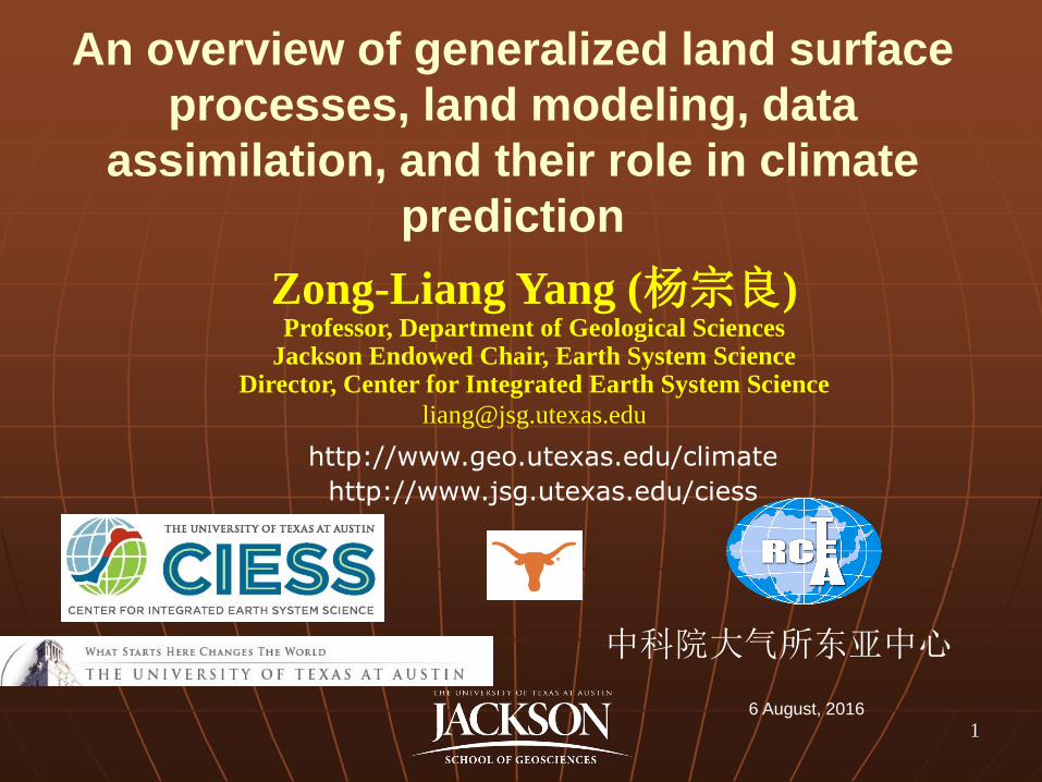
Zong-Liang Yang (杨宗良) Professor, Department of Geological Sciences
Jackson Endowed Chair, Earth System Science Director, Center for Integrated Earth System Science
http://www.geo.utexas.edu/climate
http://www.jsg.utexas.edu/ciess
6 August, 2016
中科院大气所东亚中心
An overview of generalized land surface
processes, land modeling, data
assimilation, and their role in climate
prediction
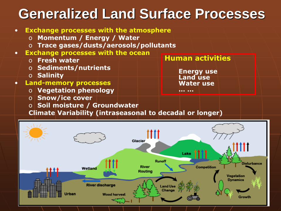
• Exchange processes with the atmosphere o Momentum / Energy / Water o Trace gases/dusts/aerosols/pollutants
• Exchange processes with the ocean o Fresh water o Sediments/nutrients o Salinity
• Land-memory processes o Vegetation phenology o Snow/ice cover o Soil moisture / Groundwater Climate Variability (intraseasonal to decadal or longer)
2
Generalized Land Surface Processes
Human activities
Energy use Land use Water use … …
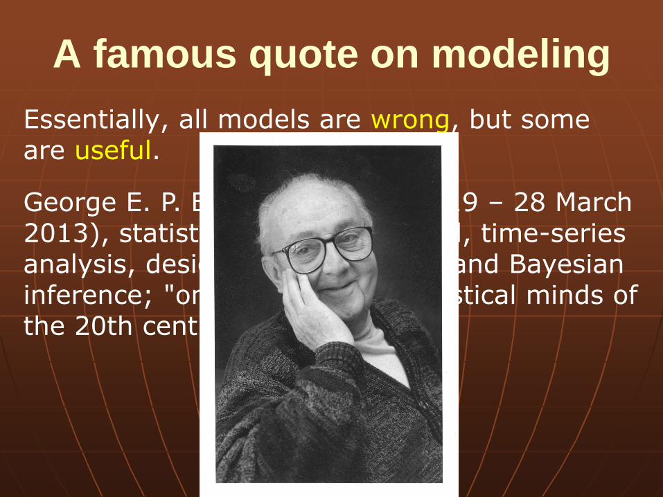
A famous quote on modeling
Essentially, all models are wrong, but some are useful.
George E. P. Box (18 October 1919 – 28 March 2013), statistician, quality control, time-series analysis, design of experiments, and Bayesian inference; "one of the great statistical minds of the 20th century".
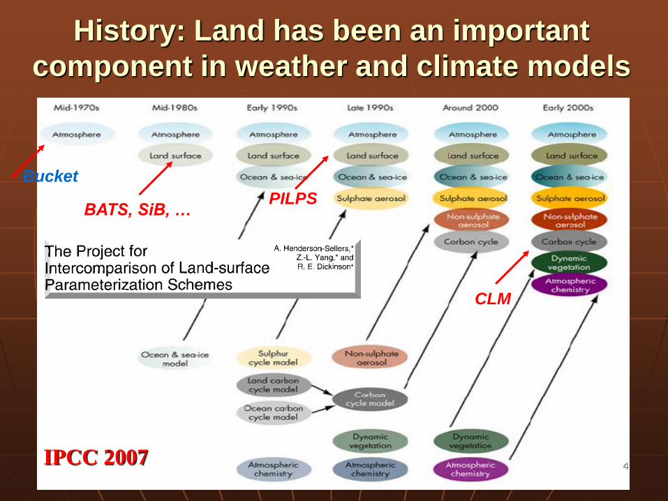
BATS, SiB, …
4
PILPS
CLM
History: Land has been an important
component in weather and climate models
IPCC 2007
Bucket
E Clark (2015)
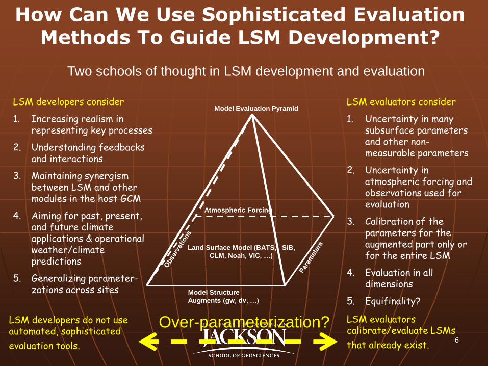
Two schools of thought in LSM development and evaluation
Atmospheric Forcing
Model Structure
Augments (gw, dv, …)
Model Evaluation Pyramid
Land Surface Model (BATS, SiB,
CLM, Noah, VIC, …)
LSM developers consider
1. Increasing realism in representing key processes
2. Understanding feedbacks and interactions
3. Maintaining synergism between LSM and other modules in the host GCM
4. Aiming for past, present, and future climate applications & operational weather/climate predictions
5. Generalizing parameter-zations across sites
LSM evaluators consider
1. Uncertainty in many subsurface parameters and other non-measurable parameters
2. Uncertainty in atmospheric forcing and observations used for evaluation
3. Calibration of the parameters for the augmented part only or for the entire LSM
4. Evaluation in all dimensions
5. Equifinality?
LSM developers do not use automated, sophisticated
evaluation tools.
LSM evaluators calibrate/evaluate LSMs
that already exist.
How Can We Use Sophisticated Evaluation Methods To Guide LSM Development?
6
Over-parameterization?
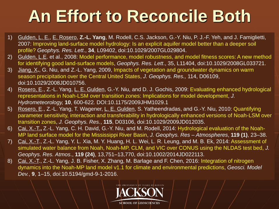
An Effort to Reconcile Both 1) Gulden, L. E., E. Rosero, Z.-L. Yang, M. Rodell, C.S. Jackson, G.-Y. Niu, P. J.-F. Yeh, and J. Famiglietti,
2007: Improving land-surface model hydrology: Is an explicit aquifer model better than a deeper soil
profile? Geophys. Res. Lett., 34, L09402, doi:10.1029/2007GL029804.
2) Gulden, L.E. et al., 2008: Model performance, model robustness, and model fitness scores: A new method
for identifying good land-surface models, Geophys. Res. Lett., 35, L11404, doi:10.1029/2008GL033721.
3) Jiang, X., G. Niu, and Z.-L. Yang, 2009, Impacts of vegetation and groundwater dynamics on warm
season precipitation over the Central United States, J. Geophys. Res., 114, D06109,
doi:10.1029/2008JD010756.
4) Rosero, E., Z.-L. Yang, L. E. Gulden, G.-Y. Niu, and D. J. Gochis, 2009: Evaluating enhanced hydrological
representations in Noah-LSM over transition zones: Implications for model development, J.
Hydrometeorology, 10, 600-622. DOI:10.1175/2009JHM1029.1
5) Rosero, E., Z.-L. Yang, T. Wagener, L. E. Gulden, S. Yatheendradas, and G.-Y. Niu, 2010: Quantifying
parameter sensitivity, interaction and transferability in hydrologically enhanced versions of Noah-LSM over
transition zones, J. Geophys. Res., 115, D03106, doi:10.1029/2009JD012035.
6) Cai, X.-T., Z.-L. Yang, C. H. David, G.-Y. Niu, and M. Rodell, 2014: Hydrological evaluation of the Noah-
MP land surface model for the Mississippi River Basin, J. Geophys. Res – Atmospheres, 119 (1), 23–38.
7) Cai, X.-T., Z.-L. Yang, Y. L. Xia, M. Y. Huang, H. L. Wei, L. R. Leung, and M. B. Ek, 2014: Assessment of
simulated water balance from Noah, Noah-MP, CLM, and VIC over CONUS using the NLDAS test bed, J.
Geophys. Res. Atmos., 119 (24), 13,751–13,770, doi:10.1002/2014JD022113.
8) Cai, X.-T., Z.-L. Yang, J. B. Fisher, X. Zhang, M. Barlage and F. Chen, 2016: Integration of nitrogen
dynamics into the Noah-MP land model v1.1 for climate and environmental predictions, Geosci. Model
Dev., 9, 1–15, doi:10.5194/gmd-9-1-2016.
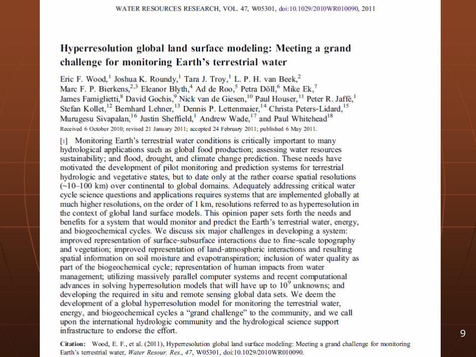
Hyperresolution global land surface
modeling: Meeting a grand challenge
for monitoring Earth’s terrestrial water
9
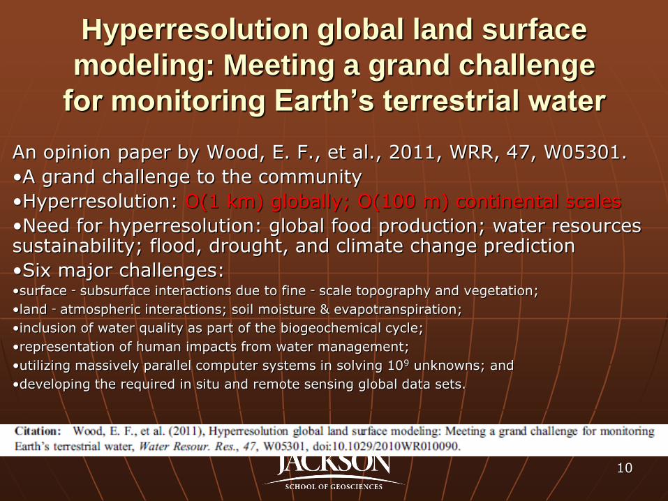
Hyperresolution global land surface
modeling: Meeting a grand challenge
for monitoring Earth’s terrestrial water
An opinion paper by Wood, E. F., et al., 2011, WRR, 47, W05301.
•A grand challenge to the community
•Hyperresolution: O(1 km) globally; O(100 m) continental scales
•Need for hyperresolution: global food production; water resources sustainability; flood, drought, and climate change prediction
•Six major challenges: •surface‐subsurface interactions due to fine‐scale topography and vegetation;
•land‐atmospheric interactions; soil moisture & evapotranspiration;
•inclusion of water quality as part of the biogeochemical cycle;
•representation of human impacts from water management;
•utilizing massively parallel computer systems in solving 109 unknowns; and
•developing the required in situ and remote sensing global data sets.
10
11
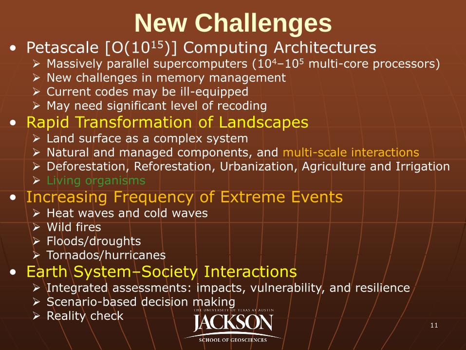
New Challenges • Petascale [O(1015)] Computing Architectures
Massively parallel supercomputers (104–105 multi-core processors) New challenges in memory management Current codes may be ill-equipped May need significant level of recoding
• Rapid Transformation of Landscapes Land surface as a complex system Natural and managed components, and multi-scale interactions Deforestation, Reforestation, Urbanization, Agriculture and Irrigation Living organisms
• Increasing Frequency of Extreme Events Heat waves and cold waves Wild fires Floods/droughts Tornados/hurricanes
• Earth System–Society Interactions Integrated assessments: impacts, vulnerability, and resilience Scenario-based decision making Reality check
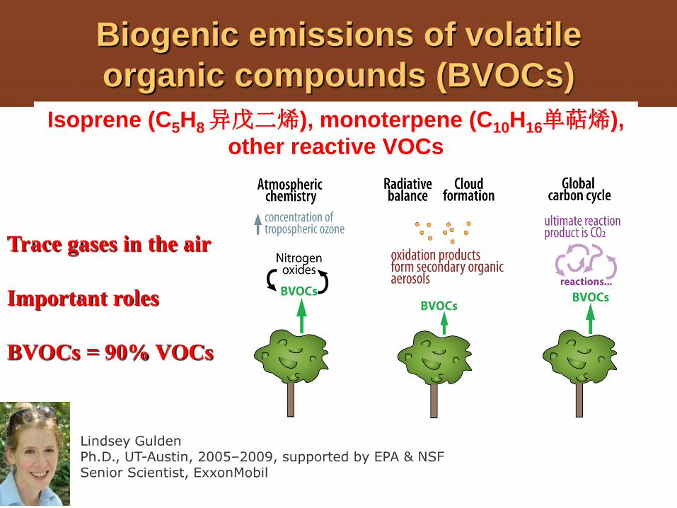
Biogenic emissions of volatile
organic compounds (BVOCs)
Trace gases in the air
Important roles
BVOCs = 90% VOCs
Lindsey Gulden Ph.D., UT-Austin, 2005–2009, supported by EPA & NSF Senior Scientist, ExxonMobil
Isoprene (C5H8 异戊二烯), monoterpene (C10H16单萜烯),
other reactive VOCs
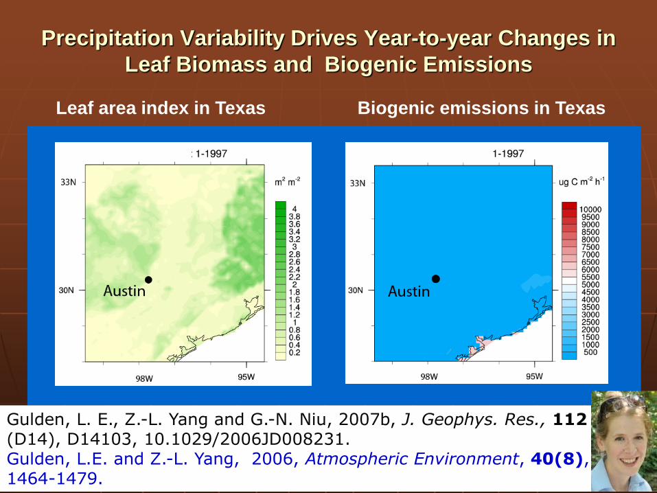
Precipitation Variability Drives Year-to-year Changes in
Leaf Biomass and Biogenic Emissions
Leaf area index in Texas Biogenic emissions in Texas
Gulden, L. E., Z.-L. Yang and G.-N. Niu, 2007b, J. Geophys. Res., 112 (D14), D14103, 10.1029/2006JD008231. Gulden, L.E. and Z.-L. Yang, 2006, Atmospheric Environment, 40(8), 1464-1479.
13
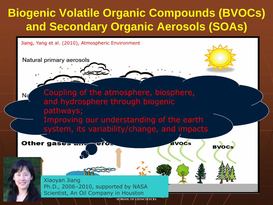
Biogenic Volatile Organic Compounds (BVOCs)
and Secondary Organic Aerosols (SOAs)
14
Coupling of the atmosphere, biosphere, and hydrosphere through biogenic pathways; Improving our understanding of the earth system, its variability/change, and impacts
Jiang, Yang et al. (2010), Atmospheric Environment
Xiaoyan Jiang Ph.D., 2006–2010, supported by NASA Scientist, An Oil Company in Houston
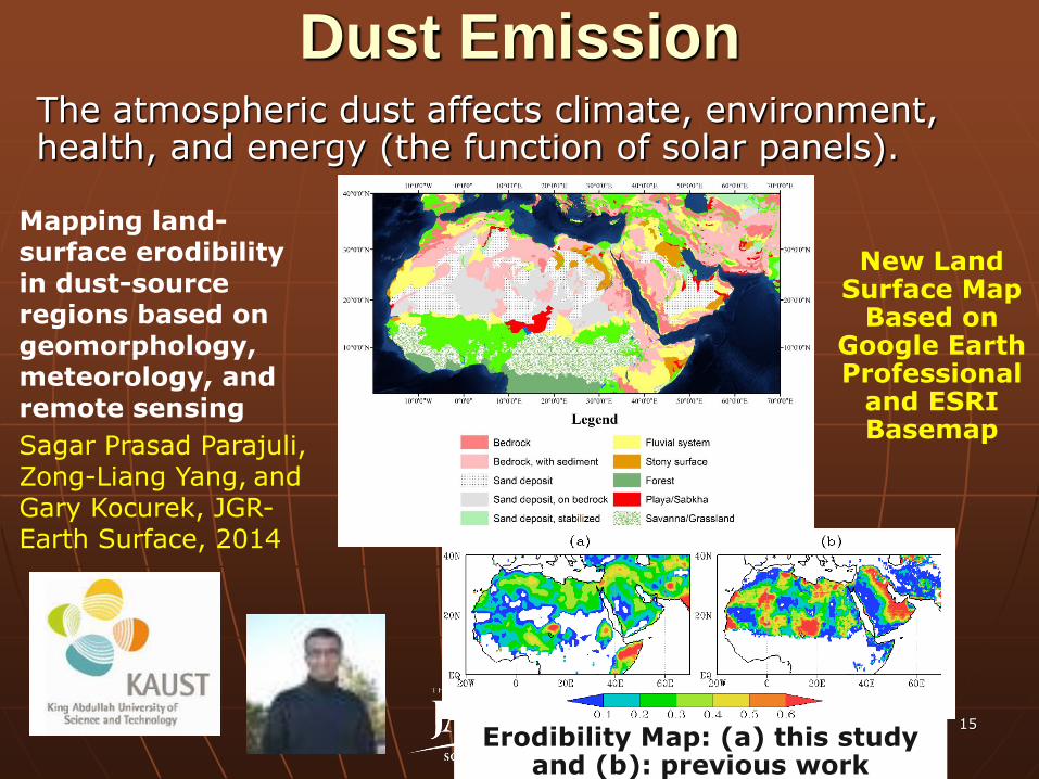
Dust Emission
15
The atmospheric dust affects climate, environment, health, and energy (the function of solar panels).
Mapping land-surface erodibility in dust-source regions based on geomorphology, meteorology, and remote sensing
Sagar Prasad Parajuli, Zong-Liang Yang, and Gary Kocurek, JGR-Earth Surface, 2014
New Land Surface Map
Based on Google Earth Professional
and ESRI Basemap
Erodibility Map: (a) this study and (b): previous work
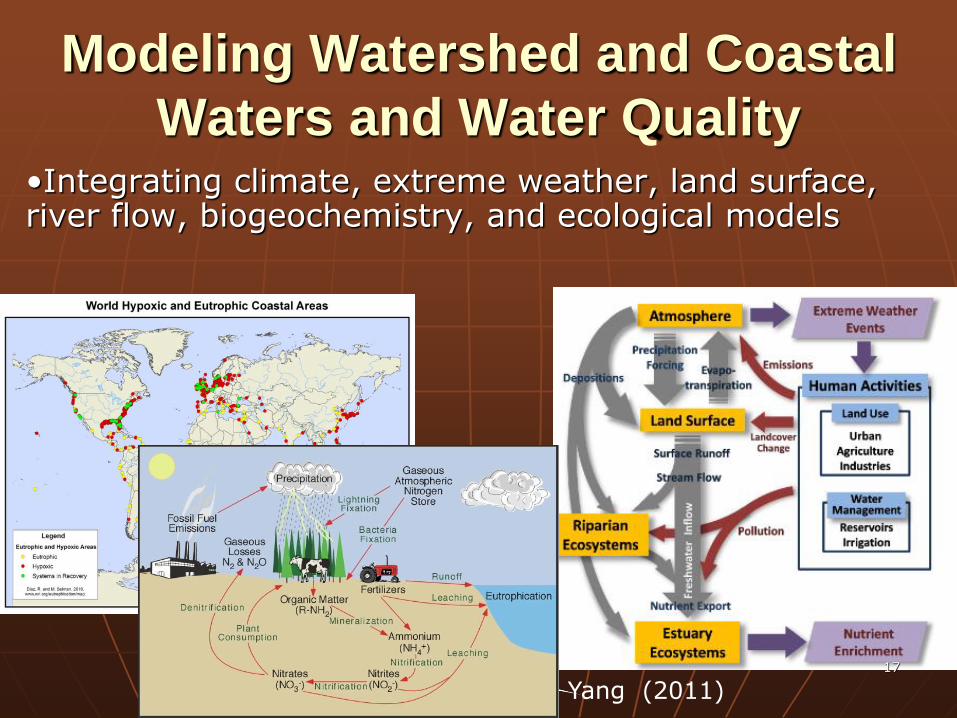
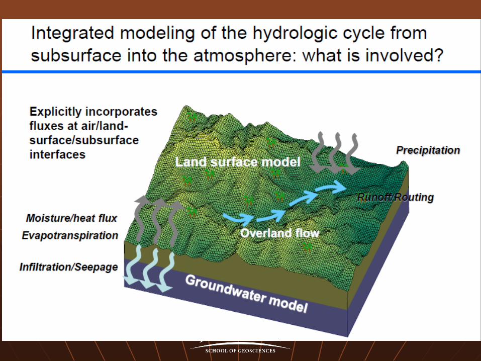
Modeling Watershed and Coastal
Waters and Water Quality •Integrating climate, extreme weather, land surface, river flow, biogeochemistry, and ecological models
Yang (2011) 17
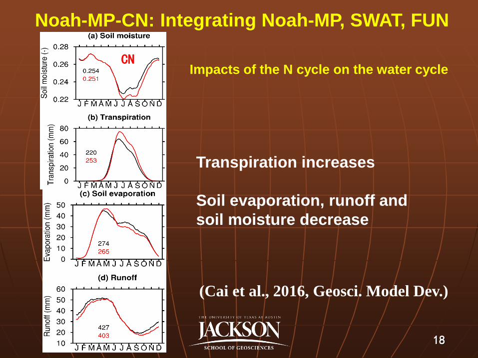
Noah-MP-CN: Integrating Noah-MP, SWAT, FUN
Impacts of the N cycle on the water cycle
(Cai et al., 2016, Geosci. Model Dev.)
CN
18
Transpiration increases
Soil evaporation, runoff and
soil moisture decrease
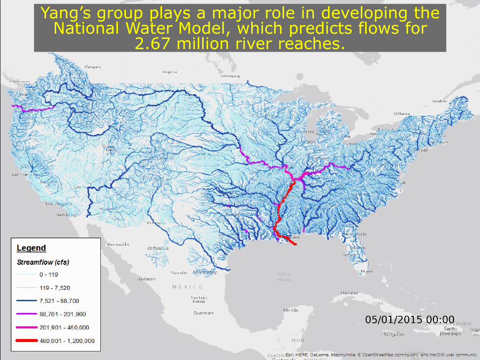
Yang’s group plays a major role in developing the National Water Model, which predicts flows for
2.67 million river reaches.
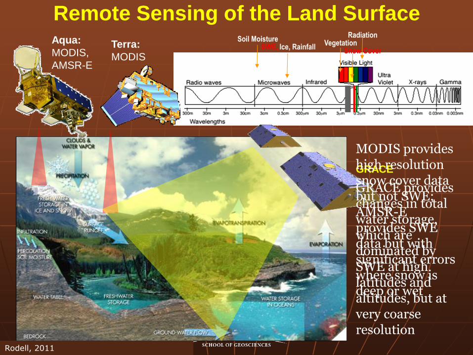
Soil Moisture SWE, Ice, Rainfall
Snow Cover Vegetation
Radiation
Remote Sensing of the Land Surface Aqua:
MODIS,
AMSR-E
GRACE
GRACE provides changes in total water storage, which are dominated by SWE at high latitudes and altitudes, but at very coarse resolution
MODIS provides high resolution snow cover data but not SWE; AMSR-E provides SWE data but with significant errors where snow is deep or wet
Terra:
MODIS
Rodell, 2011
21
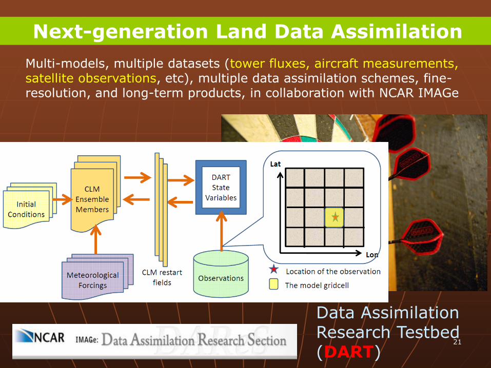
Data Assimilation Research Testbed (DART)
Multi-models, multiple datasets (tower fluxes, aircraft measurements, satellite observations, etc), multiple data assimilation schemes, fine-resolution, and long-term products, in collaboration with NCAR IMAGe
Next-generation Land Data Assimilation
GPM
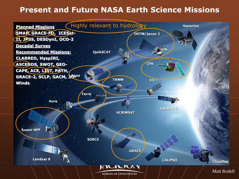
Present and Future NASA Earth Science Missions
Planned Missions
SMAP, GRACE-FO, ICESat-
II, JPSS, DESDynI, OCO-2
Decadal Survey
Recommended Missions:
CLARREO, HyspIRI,
ASCENDS, SWOT, GEO-
CAPE, ACE, LIST, PATH,
GRACE-2, SCLP, GACM, 3D-
Winds
Highly relevant to hydrology
Matt Rodell
33
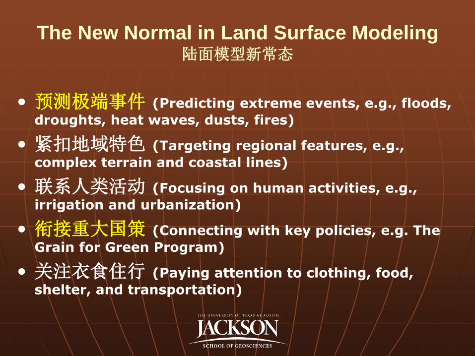
The New Normal in Land Surface Modeling 陆面模型新常态
• 预测极端事件 (Predicting extreme events, e.g., floods,
droughts, heat waves, dusts, fires)
• 紧扣地域特色 (Targeting regional features, e.g.,
complex terrain and coastal lines)
• 联系人类活动 (Focusing on human activities, e.g.,
irrigation and urbanization)
• 衔接重大国策 (Connecting with key policies, e.g. The
Grain for Green Program)
• 关注衣食住行 (Paying attention to clothing, food,
shelter, and transportation)
Thank You!
EPA
DHS
NASA
NOAA
NSF
NSFC
KAUST
TACC
Xitian Cai, Dr. Cedric David, Dr. Lindsey Gulden Lisa Helper Myer, Dr. Bryan Hong Dr. Xiaoyan Jiang, Dr. Marla Knebl
Dr. Jeff Lo, Dr. Guo-Yue Niu Dr. Enrique Rosero, Dr. Hua Su, Ahmad Tavakoly,
Zhongfeng Xu, Jiangfeng Wei, Yongfei Zhang Drs. David Allen, Gordon Bonan,
Fei Chen, Jianli Chen, Robert Dickinson, Michael Ek, Congbin Fu, David Gochis, Alex
Guenther, David Lawrence, Zhuguo Ma, David Maidment, Kenneth Mitchell, Keith Oleson, Roger
Pielke Sr., Georgiy Stenchikov, Clark Wilson, Christine Wiedinmyer
26
• http://www.jsg.utexas.edu/ciess

![Generalized Linear Model Generalized Linear Model [[GLMGLM]] · Generalized linear models No. of obs = 100 Optimization : ML: Newton-Raphson Residual df = 98 Scale param = 1 Deviance](https://img.pdfslide.tips/doc/110x75/5f64725087b77a66e73cf63c/generalized-linear-model-generalized-linear-model-glmglm-generalized-linear.jpg)