Embed Size (px)
Citation preview
ANNALES GEOLOGIQUES DES Ñ Á YS HELLENIQUESPUBLIEESSOUS LA DIRECfION DE DEPARTEMENT DE GEOLOGIE DE L' UNlVERSITE D' ATHENES
DRINIA, Ç., DERMITZAKIS, M.D., KOULI, Ê. & ÔÇ. TSOUROU
SEDIMENTARY FACIES ANALYSIS AND PALEOENVIRONMENTALINTERPRETATION ÏÑ VATERA FORMATION, LESVOS ISLAND, GREECE
ÍÔÑÉÍÉÁ ×., ÄÅÑÌÉÔÆÁÊÇÓ, Ì.Ä., ÊÏÕ ËÇ, Ê. & È. ÔÓÏÕÑÏÕ
ÉÆÇÌÁÔÏÃÅÍÇÓ ÁÍÁË ÕÓÇ ÖÁÓÅÙÍ ÊÁÉ ÐÁËÁÉÏÐÅÑÉÂÁËËÏÍÔÉÊÇÅÑÌÇÍÅÉÁ ÔÏÕ Ó×ÇÌÁÔÉÓÌÏÕ ÂÁÔÅÑÙÍ ÓÔÇ ÍÇÓÏ ËÅÓÂÏ, ÅËËÁÄÁ
ATHENESDEPARTEMENT DE GEOLOGIEPanepistimiopolis, Athenes (15784)
2002

SEDIMENTARY FACIES ANALYSIS AND PALEOENVIRONMENTALINTERPRETATION OF V ATERA FORMATION,
LESVOS ISLAND, GREECE.*
byDRINIA, Ç., DERMUZAKIS, M.D., KOULI, Ê. & Th. TSOUROU**
É. INTRODUCTION-GEOLOGICAL SETTING
Lesvos is one of the main islands of the Eastem Aegean Sea (Fig. 1).Crucial role ßn the kinematics of the Aegean region plays the northward subduction
of the African plate beneath the Aegean lithosphere. As the African plate movesnorthwards, strike slip displacements along the Dead Sea fault zone causes compressionbetween the Arabian and the Eurasian plates. This process results ßn a crustal thickening
Fig. 1. Map of Lesvos island and the surrounding area (after PE-PIPER, 1978).
. læçìáôïãåíÞò áíÜëõóç øÜóåùí êáé ðáëáéïðåñéâáëëïíôéêÞ åñìçíåßá ôïõ Ó÷çìáôéóìïý Âáôåñþí óôç íÞóï ËÝóâï,
ÅëëÜäá... Åèíéêü êáé Êáðïäéóôñéáêü ÐáíåðéóôÞìéï Áèçíþí, ÔìÞìá Ãåùëïãßáò, ÔïìÝáò lóô. Ãåùëïãßáò êáé Ðáëáéïíôï-
ëïíßác. Ðáíåðéóôçìéüðïëç 157 84, Áè1'éíá, ÅëëÜäá.
-16-
of Å. Turkey. As a result, the Aegean and the Anatolian plates are being pushed west-wards causing the extension of the Aegean region towards the eastem Mediterranean.This mov.ement is expressed through the North Anatolian Fault and its extension intothe Aegean Sea.
The island of Lesvos belongs to the Aegean microplate and therefore it is affectedfrom the extensional field of the Aegean. Éç addition, and due to its vicinity to thesouthwestem branch of tìe North Anatolian fault, which is one of the main tectonicfeatures ßç Turkey, it is also affected from the major earthquakes originating from thisfault system.
The geology of Lesvos island has been described by HECHT (1971; 1974; 1975), ÑÅ-PIPER (1978), KATSIKATSOS et áÉ (1982; 1986). HECHT (1971; 1974) presented thegeological map of the island (1:50.000 scale).
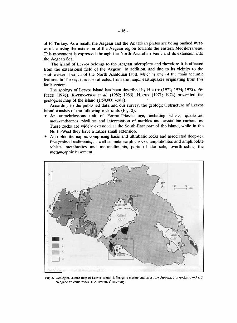
According to the published data and our survey, the geological structure of Lesvosisland consists of the following rock units (Fig. 2):. Áç autochthonous unit of Permo- Triassic age, including schists, quartzites,
metasandstones, phyllites and intercalation of marbles and crystalline carbonates.These rocks are widely extended at the South-East part of the island, while ßç theNorth-West they have a rather small extension.
. Áç ophiolitic nappe, comprising basic and ultrabasic rocks and associated deep-seafine-grained sediments, as well as metamorphic rocks, amphibolites and amphiboliteschists, metabasites and metasediments, parts of the sole, overthrusting themetamorphic basement.
Fig. 2. Geo!ogica! sketch map ïß Lesvos is!and. 1. Neogene marine and !acustrine deposits, 2. Pyroc!astic rocks, 3.
Neogene vo!canic rocks, 4. A!!uvium, Quatemary.
-17-
. Post-alpine volcanic rocks and Neogene marine and lacustrine deposits such aswhitish marls, marly limestone, silts and sandstone, as well as Tertiary deposits whichcover the alpine and pre-alpine rocks.
The Neogene volcanic rocks dominate the central and westem part ïß the island.Lesvos is part ïß a belt ïß late Oligocene-middle Miocene calc-alcaline to shoshonitic
volcanism ïß the northem and central Aegean sea and westem Anatolia. Éç the centralpart ïß the island there is a series ïß volcanic centers, situated along a SW-NE direction.
Kinematic analysis carried out ßç Lesvos showed that several successive tectonicevents took place duÞng Cenozoic. According to MERCIER et á/. (1989) and DOTSICA etá/. (1995), Lesvos island suffered at least three post-volcanic tectonic events sinceMiocene. The first one produced Å- W to ÅÍÅ- WSW trending sinistral strike-slip faultsßç Late Miocene. The second one (Pliocene), caused NW-SE trending normal faults andNNE-SSW trending sinistral strike-slip faults. Finally, during Pleistocene, the orientationïß the strain ellipsoid changed and an extensional event ßç N-S direction took place,producing Å- W trending normal faults and the reactivation ïß the pre-existing structures.This tectonic regime seems to be still active ßç the area (PAPAZACHOS et áÉ1990).
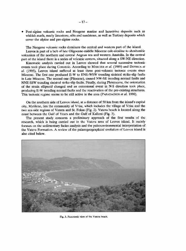
Ïç the southern side ïß Lesvos island, at a distance ïß 50 km from the island's capitalcity, Mytilene, lies the community ïß Vrisa, which includes the village ïß Vrisa and thetwo sea-side regions ïß Vatera and 51. Fokas (Fig. 2). Vatera beach is located along thecoast between the Gulf ïß Years and the Gulf ïß Kalloni (Fig. 3).
The present study concerns a preliminary approach ïß the first results ïß theresearch, which is being carried out ßç the Vatera area ïß Lesvos island. It mainlyfocuses ïç the sedimentary facies analysis and the paleoenvironmental interpretation ïßthe Vatera Formation. Á review ïß the palaeogeographical evolution ïß Lesvos island isalso cited below.
Fig. 3. Panoramic view ïß the Vatera beach.
-18-
11. SEDIMENTARY FACIES ANAL YSIS
Én the study area, which is located between the Cape ïß Ag. Fokas and í atera beach,Íeïgeç'e deposits are developed. Their stratigraphic analysis showed that at their base,marly limestones with intercalations ïß sandstones and tuffites are found.
Two different depositional environments were recognized: a ÉacustÞne-brackishenvironment ßn the lower part and a braided river environment ßn the upper part ïß thesuccession. The lacustrine, alluvial -lacustrine sequences consist ïß teuigenous andsiliceous biogenic deposits (diatomites). This unit overlie conformably the volcanic rocks.
Clayey, sandy and muddy sediments crop out widely. í ery thick conglomeratebodies crop out ßn facies ïß alluvial fan. They are overlain by clayey-sandy and muddysediments interbedded with conglomerates, in facies ïß braided-plain.
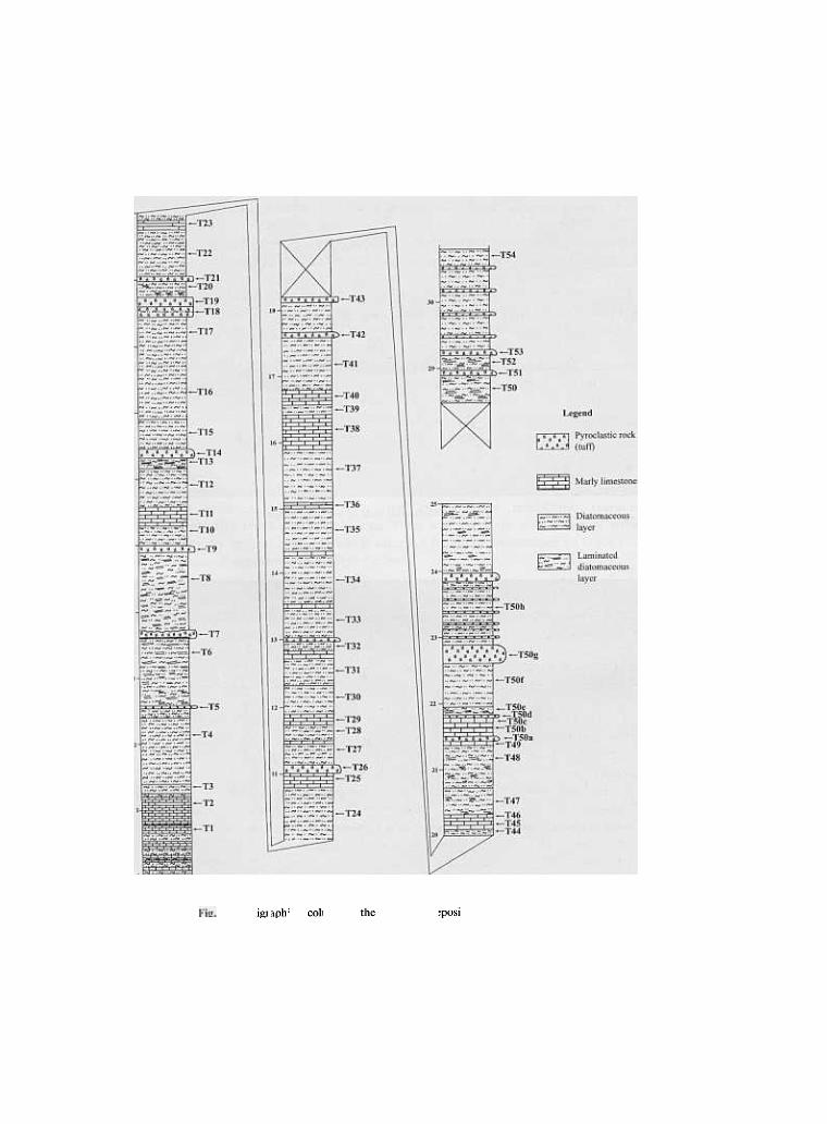
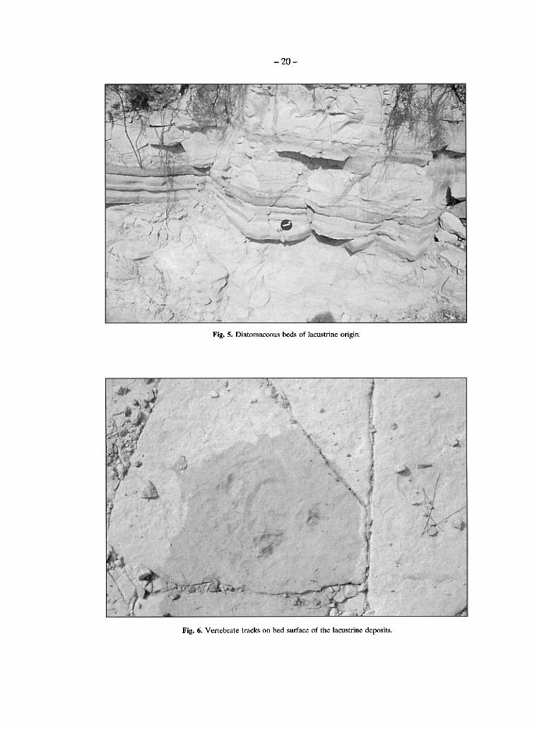
Lácustrine DepositsThe first section taken is about 30 m thick and is composed ïß three main facies:
Clayey muds, calcareous muds and diatomaceous muds (Fig. 4, 5).This formation begins usually with fine laminated, white and friable diatomaceous
muds overlain by dark-green muds. The dark-green muds transitionally change to sandydeposits.
lç place, diatomite is soft and "punky" and has a chalklike appearance. It is knownthat color may vary from snow white ßç a pure, well-bleached and dry deposit, to olivegreen or darker where substantial organic remains are still present and where moisturecontent is high.
The green layers are a mixture ïß detrital and 4iatom frustules, while the creamlayers are mostly diatom rich. The transition from diatomaceous couplets to detritaldeposits is often gradual and involves a reduction ïß the number ïß diatom laminae andan initial thickening ïß clay layers, followed by a change to silty or sandy muds.
Sandy facies constitute the coarsest sediments and represent littoral platformdeposits and specific high-energy sublacustrine sedimentary environment. The sandybodies are considered as a single, massive body, although each ïß them has a limitedlateral extension and are discontinuous.
lç addition, a large amount ïß volcanic material is intercalated with ßç the diatoma-ceous rocks.
Íï precise dating could be achieved due to the volcanic rock alteration and due tothe fact that the ash deposits ßç the basin sequence are often reworked.
The section has been sampled every 30 cm for paleontological analyses. Molluscs arescarce with undeterminable fragments ïß shells.
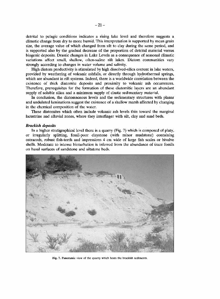
lç addition, two types ïß vertebrate tracks have been recognized ïç bed surfaces (Fig. 6):1) tracks consisting ïß the imprint ïß four fingers reaching ßç total 2 cm ßç length. This
type ïß track seems to cïðeSÑïçd to a carnivore ïß small size and2) depressions with a rather circular geometry. They do not show clear finger forms or
other clear anatomic features. This circular tracks could be related to print ïß pawsor hoofs covered by mud.The vertebrate tracks made by mammals record the life activity ïß other organisms
that were related to water availability. Recognition ïß vertebrate tracks does not seemto be significant for palaeoenvironmental reconstruction except from the fact theycommonly occur ßç association with marginallake deposits.
The whole section is characterized by the presence ïß cyclicity. The change from
-20-
Fig. 5. Diatomaceous beds of lacustrine origin.
Fig. 6. Vertebrate tracks óç bed surface óß the lacustrine deposits.
-21-
detrital to pelagic conditions indicates a rising lake level and therefore suggests aclimatic change from dry to more humid. This interpretation is supported by mean grainsize, the average value of which changed from silt to clay during the same period, andis supported also by the gradual decrease of the proportion of detrital material versusbiogenic deposits. Drastic changes ßç Lake Levels as a consequence of seasonal climaticvaÞatßïns affect small, shallow, often-saline rift lakes. Diatom communities varystrongly according to changes ßç water volume and salinity.
High diatom productivity is stimulated by high dissolved-silica content ßç lake waters,provided by weathering of volcanic ashfalls, or directly through hydrothermal springs,which are abundant ßç rift systems. Indeed, there is a worldwide correlation between theexistence of thick diatomite deposits and proximity to volcanic ash occurrences.Therefore, prerequisites for the formation of these diatomitic layers are an abundantsupply (jf soluble silica and a minimum supply of clastic sedimentary material.
Éç conclusion, the diatomaceous 1evels and the sedimentary structures with plan:arand undulated laminations suggest the existence of a shallow marsh affected by changingßç the chemical composition of the water.
These diatomites which often include volcanic ash levels thin toward the marginallacustrine and alluvial zones, where they intedinger with silt, clay and sand beds.
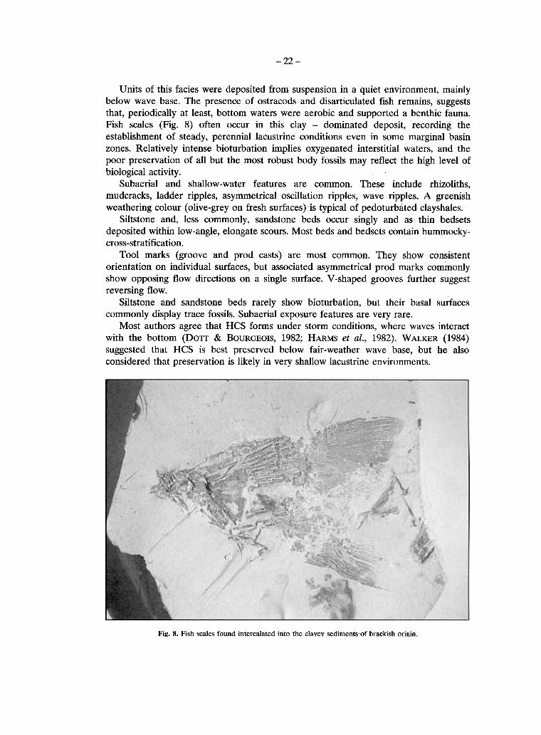
Brackish depositsÉç a higher stratigraphicallevel there is a quarry (Fig. 7) which is composed ïß platy,
or irregularly splitting, fossil-poor claystone (with minor mudstone) containingostracods, robust fish-teeth and impressions 4 cm wide ïß large fish scales or bivalveshells. Modetate to intense bioturbation is inferred from the abundance ïß trace fossilsïç basal surfaces ïß sandstone and siltstone beds.
Fig. 7. Panoramic view of the quarry which hosts the brackish sediments.
-22-
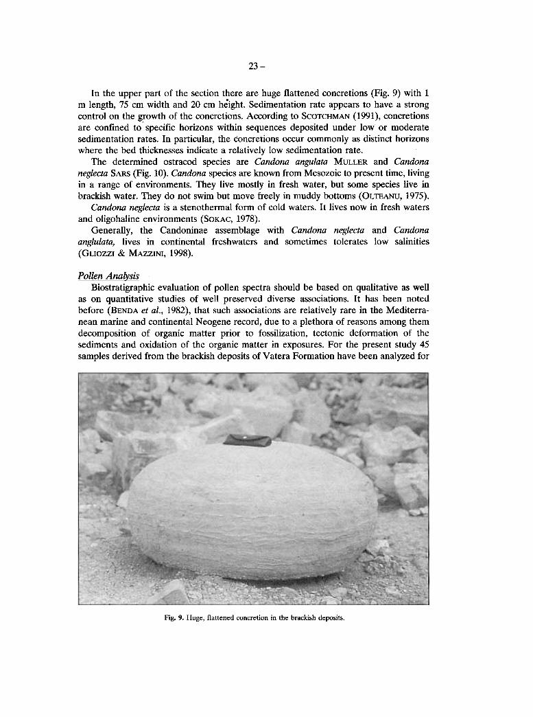
Units of this facies were deposited from suspension ßï a quiet environment, mainlybelow wave base. The presence of ostracods and disarticulated fish remains, suggeststhat, periodically at least, bottom waters were aerobic and supported a benthic fauna.Fish scales (Fig. 8) often occur ßç this clay - dominated deposit, recording the
establishment of steady, perennial lacustrine conditions even ßç some marginal basinzones. Relatively intense bioturbation implies oxygenated interstitial waters, and thepoor preservation of all but the most robust body fossils may reflect the high level of
biological activity.Subaerial and shallow-water features are common. These include rhizoliths,
mudcracks, ladder ripples, asymmetrical oscillation ripples, wave ripples. Á greemshweathering colour (olive-grey ïç fresh surfaces) is typical of pedoturbated clayshales.
Siltstone and, less commonly, sandstone beds occur singly and as thin bedsetsdeposited within low-angle, elongate scours. Most beds and bedsets contain hummocky-cross-stratification.
Tool marks (groove and prod casts) are most common. They show consistentorientation ïç individual surfaces, but associated asymmetrical prod marks commonlyshow opposing flow directions ïç a single surface. í -shaped grooves further suggestreversing flow.
Siltstone and sandstone beds rarely show bioturbation, but their basal surfacescommonly display trace fossils. Subaerial exposure features are very rare.
Most authors agree that HCS forms uoder storm conditions, where waves interactwith the bottom (Dïð & BOURGEOIS, 1982; HARMS et áÉ., 1982). W ALKER (1984)suggested that HCS is best preserved below fair-weather wave base, but he alsoconsidered that preservation is likely ßç very shallow lacustrine environments.
Fi2. 8. Fish scales found intercalated into the clavev sediments{)f brackish ïÞ2ßç.
23-
lç the upper part ïß the section there are huge flattened concretions (Fig. 9) with 1m length, 75 cm width and 20 cm height. Sedimentation rate appears to have a strongcontrol ïç the g!owth ïß the concretions. According to SCOTCHMAN (1991), concretionsare confined to- specific horizons within sequences deposited under low or moderatesedimentation rates. lç particular, the concretions occur commonly as distinct horizonswhere the bed thicknesses indicate a relatively low sedimentation rate.
The determined ostracod species are Cándoná ángulátá MULLER and Cándonáneglectá SARS (Fig. 10). Cándoná species are known from Mesozoic to present time, livßïgßç a range ïß environments. They live mostly ßç fresh water, but some species live ßïbrackish water. They do not swim but move freely ßç muddy bottoms (OLTEANU, 1975).
Cándoná neglectá is a stenothermal form ïß cold waters. It lives now ßç fresh watersand oligohaline environments (SOKAC, 1978).
Generally, the Candoninae assemblage with Cándoná neglectá and Cándonáánglulátá, lives ßç continental freshwaters and sometimes tolerates low salinities(GLIOZZI & ÌÁÆÆÉÍÉ, 1998).
Pollen AnálysisBiostratigraphic evaluation ïß pollen spectra should be based ïç qualitative as well
as ïç quantitative studies ïß well preserved diverse associations. It has been notedbefore (BENDA et áÉ, 1982), that such associations are relatively rare ßç the Mediterra-nean marine and continental Neogene record, due to a plethora ïß reasons among themdecomposition ïß organic matter prior to fossilization, tectonic deformation ïß thesediments and oxidation ïß the organic matter ßç exposures. For the present study 45samples derived from the brackish deposits ïß Vatera Formation have been analyzed for
Fig. 9. Huge. flattened concretion ßç the brackish deposits.

-24-
Fig. 10. The ostracod species found ßç samples from the quarry brackish sediments.1) Cándoná ánglulátá MULLER, outside view of a left valve.2) Cándoná neglectá SARS; outside view of a right valve.
palynomorphs. Ïß them only 11 contain well-preserved palynomorphs. 4 ïß them lendthemselves to a: quantitative analysis but ßn the rest, pollen exines were found extremelly
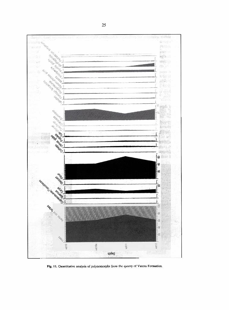
rarely.The studied samples (Fig. 11) show clearly an abundance ïß tree pollen over herbs
arid arbustes. Microf1ora is moderately preserved and include 41 different taxa ïß pollenand spores. Én the studied samples the arboreal microf1ora is characterized by abundantPinus and Cáryá pollen grains as well Ulmus and Cátháyá. Among other angiosperms we
25
4~daa
Fig. 11. Quantitative analysis of palynomorphs from the quarry of Vatera Forrnation.
-26-
see smaller amounts ïß pollen ïß Oleaceae, Cupresaceae/Taxodiaceae and Populus.Pollen grains ïß Acer, Alnus, Ca1pinus, ÔßÉßá and Rhamnaceae are also sporadicallyobserved. Pollen grains ïß non-arboreal plants are common and are mainly representedby Gamineae, followed by Polygonaceae, Asteraceae and Labiateae.
Pollen grains ïß swamp depended plants, mainly Typhaceae, are commïn ßn alllevels.Pteridophytes spores are observed ßn almost every sample but their frequency is extremelylow.
The aquatic signal ïß the brackish deposits consists ïß. dinoflagellate cysts and somecenobia ïß Pediastrnm bo1Yanum (Chlorophyceae).
The extremely low frequencies ïß steppic and Mediterraneaç elements, the almostabsence ïß subtropical taxa and the general composition ïß the microflora indicates thatdeposition ïß the studied sediinents took. place under warm-temperate humid climaticconditions.
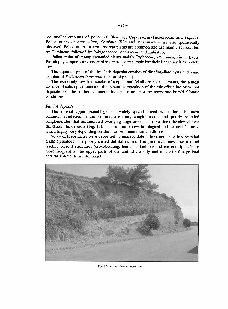
Fluíial depositsThe alluvial upper assemblage is a widely spread fluvial association. The most
common lithofacies ßç the sub-unit are sand, conglomerates and poorly roundedconglomerates that accumulated overlying large erosional truncations developed overthe diatomitic deposits (Fig. 12). This sub-unit shows lithological and textural features,which highly vary depending ïç the local sedimentation conditions.
Some ïß these facies were deposited by massive debris flows and show low roundedclasts embedded ßç a poorly sorted detrital matrix. The grain size fines upwards andtractive cunent structures (cross-bedding, lenticular bedding and cunent ripples) aremore frequent at the upper parts ïß the unit where silty and epiclastic fine-graineddetrital sediments are dominant.
Fig. 12. Stream flow con~lomerates.
-27.
Breccia, conglomerates, and a high percentage of arenaceous material which ßlpresented either as the matrix of breccia-conglomerates or as particular interbedlbetween the above formations or even between beds of clay are present. Pebbles a«coming from th6 tuffs, the lava and the Neogene silicified marls.
The type section is located along the main road from Vrissa to Vatera about 1knsoutheast of the village Vrissa. The section has a thickness of about 20 m and shows 1succession of breccia - conglomerates that pass gradually into an alternation of sand~
. clays and sandy breccia - conglomerates.The conglomerate beds consist of clast-supported pebble and cobble gravels witl
crude horizontal s.tratification. This deposit has a clast framework and an abundant san<matrix. Bed contacts may be obscure because of the absence of wel1-defined bedding.
This facies can be described as a smal1-scale fining-upward sequence (1-2 m thick)consisting of a composite unit of conlomerate overlain by pebbly sandstone. The bedare crudely stratified, clast-supported, with sub-angular to subrounded clasts, arucommonly wel1-sorted and graded.
The texture and stratification of the clast-supported conglomei1:ltes strongly suggesa stream-f1ow origin. Evidence for stream f1ow processes includes'uamework supporand the crude fining-upward trends of individual units.
Fine-grained clastic sediments are deposited primarily from the suspension load ïrivers.
Deposits of mud, silt and very fine sand indicate deposition én f1ood plain areas, ß]abandoned channels.
During the Late Pliocene-Early Pleistocene the braided plain underwent thlinf1uenee of marine waters. This inf1uence is recorded by' the brackish ostracocassemblages col1ected ßn the continental sands and clays sedimented inside the basin.
11É. PALAEOGEOGRAPHICAL EVOLUTION OF LESVOSISLANI
It is well known that the studyof fossil mammals ïç islands is interesting as theycalgive information ïç palaeogeography and ßç consequence ïç tectonic movement:(DERMITZAKIS & SONDAAR, 1979).
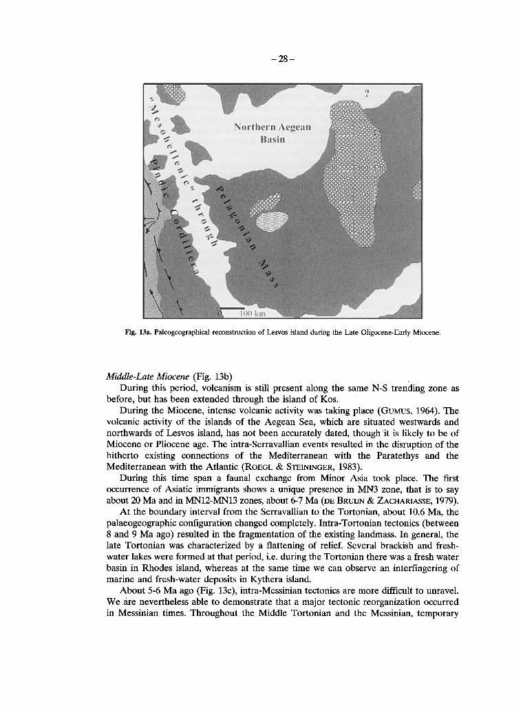
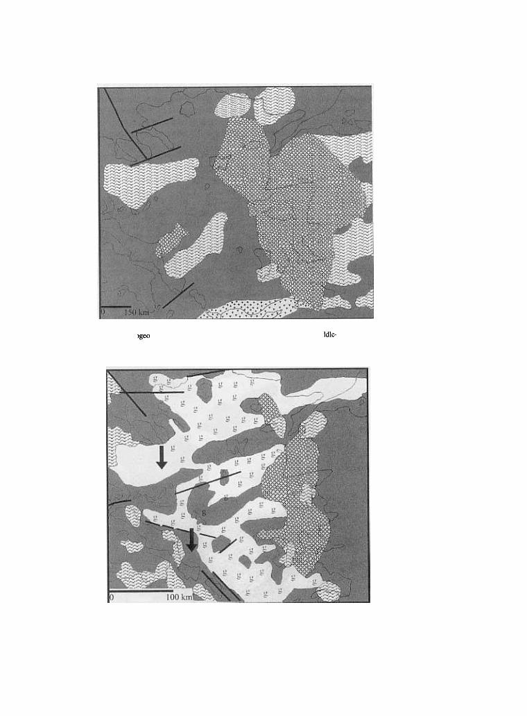
Palaeogeographical sketches, indicating the relative positions of various palaeogeographical domains during some critical periods, will describe the palaeogeographicaevolution of Lesvos Island during the Late Cenozoic (Fig.13, DERMaZAKIS, 1996DERMITZAKIS & DRINIA, 1999).
Láte Oligocene-Eárly Miocene (Fig. 13a)Á volcanic zone from Eastern Thrace to the North of Samos 1sland,going paralle
to the present cQastline of Minor Asia, is evident.Én North Aegean region, volcanic rocks of Late Eocene or Oligocene age are wel
extended.During the same period in the NW part of Lesvos 1sland a Petrified Forest is burie<
in tuffites from the nearby volcano. This rather extended Petrified Forest is ïautochthonous origin. 1ts formation is highly connected with the volcanic activity of thIsurrounding area of Lesvos 1sland. 1t is believed that the Forest of Lesvos 1sland has beeIgrowing during subtropical climatic conditions, which abruptly changed into continentaltrf\nir~ 1 rlim~tir ~f\nciitif\né; NFT .TT7F.T()S & GRFG()R. 199(): SI JSS & VELTTZELOS. 1997).
-28-
Fig. 13a. Paleogeographical reconstruction ïß Lesvos island during the Late Oligocene-Early Miocene.
Middle-Láte Miocene (Fig. 13b)During this period, volcanism is still present along the same N-S trending zone as
before, but has been extended through the island ïß Kos.During the Miocene, intense volcanic activity was taking place (GUMUS, 1964). The
volcanic activity ïß the islands ïß the Aegean Sea, which are situated westwards andnorthwards ïß Lesvos island, has not been accurately dated, though u is likely to be ïßMiocene or Pliocene age. The intra-Serravallian eventsresulted ßn the disruption ïß thehitherto existing connections ïß the Mediterranean with the Paratethys and theMediterranean with the Atlantic (ROEGL & STEININGER, 1983).
During this time span a faunal exchange from Minor Asia took place. The firstoccurrence ïß Asiatic immigrants shows a unique presence ßn ÌÍ3 zone, that is to sayabout 20 Ma and ßn ÌÍI2-ÌÍI3 zones, about 6-7 Ma (DE BRUIJN & ZACHARIASSE, 1979).
At the boundary interval from the Serravallian tothe Tortonian, about 10.6 Ma, thepalaeogeographic configuration changed completely. Intra- Tortonian tectonics (between8 and 9 Ma ago) resulted ßn the fragmentation ïß the existing landmass. Én general, thelate Tortonian was characterized by a flattening ïß relief. Several brackish and fresh-water lakes were formed at that period, i.e. during the Tortonian there was a fresh waterbasin ßn Rhodes island, whereas at the same time we can observe an interfingering ïßmarine and fresh-water deposits in Kythera island.
About 5-6 Ma ago (Fig. 13c), intra-Messinian tectonics are more difficult to unravel.We are nevertheless able to demonstrate that a major tectonic reorganization occurredßn Messinian times. Throughout the Middle Tortonian and the Messinian, temporary
-30-
connections between the Mediterranean and the Northem Aegean existed, withouthowever creating "bamers" preventing mammal migrations from Minor Asia. Duringthis part of Late Miocene, the former Aegean mainland formed an archipelago, ßn whichlandbridges between Minor Asia and Greece made the arrival of a large number ofAsiatic steppe immigrants and African elements to the present Greece possible.
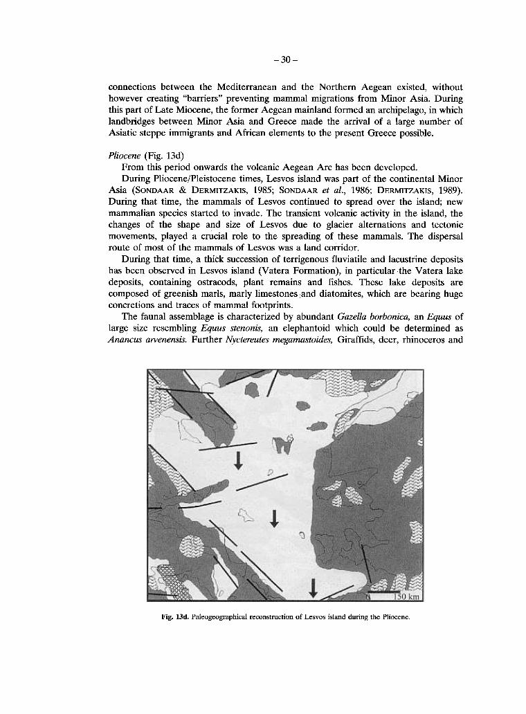
P!iocene (Fig. 13d)From this period onwards the volcanic Aegean Arc has been developed.During Pliocene/Pleistocene times, Lesvos island was part ïß the continental Minor
Asia (SONDAAR & DERMITZAKIS, 1985; SONDAAR et áÉ, 1986; DERMITZAKIS, 1989).DuÞng that time, the mammals ïß Lesvos continued to spread over the island; newmammalian species started to invade. The transient volcanic activity ßn the island, thechanges ïß the shape and size ïß Lesvos due to glacier altemations and tectonicmovements, played a crucial role to the spreading ïß these mammals. The dispersalroute ïß most ïß the mammals ïß Lesvos was a land cïðßdïr.
During that time, a thick succession ïß teðßgenïus fluviatile and lacustrine depositshas been observed ßn Lesvos island (Vatera Formation), ßn particular the Vatera lakedeposits, containing ostracods, plant remains and fishes. These lake deposits arecomposed of greenish marls, marly limestones land diatomites, which are bearing hugeconcretions and traces ïß mammal footprints.
The faunal assemblage is characterized by abundant Gázellá borbonicá, an Equus ïßlarg~ size resembling Equus stenonis, an elephantoid which could be determined asAnáncus álVenensis. Further Nyctereutes megámástoides, Giraffids, deer, rhinoceros and
Fig. 13d. Paleogeographical reconstruction ïß Lesvos island during the Pliocene.
-31-
a sabre tooth cat. The presence of a dwarf antelope, a giant tortoise and a large teðestrßaÉmonkey (Párádolichopithecus) makes it unique. The discovery of this balanced faunasupports the conclusion that the island of Lesvos was connected with Minor Asia. Thispalaeobiogeograpliical interpretation is ßç accordance with the geomorphological,lithostratigraphical and tectonic observations, which showed that Lesvos became anisland during Holocene.
The floral association is characterized by a long interval with temperate flora. Thebeds are reversely magnetized with a short normal episode at the base. V áÍ VUGT (pers.Comm.) cïðelates the short normal interval with the older Reunion event (2.18 - 1.942
ÌÕ). Éç addition the presence of Nyctereutes and Párádolichopithecus points a LatePliocene age.
The abundance of the Gázellá, horses and antelope fossils indicates an open and dryenvironment, which cïðeSÑïçds to dry savannah or open forests. The sedimentsindicate a river system with the possibility of forest ïç the banks.
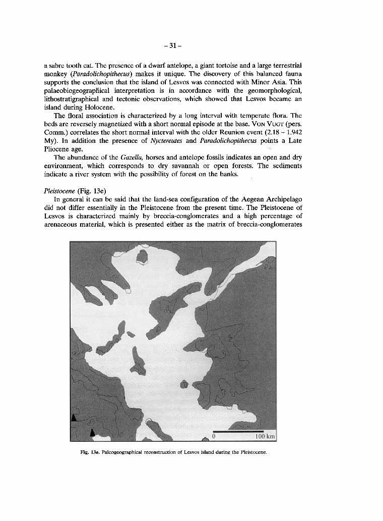
Pleistocene (Fig. 13e)Éç general it can be said that the land-sea configuration of the Aegean Archipelago
did not differ essentially ßç the Pleistocene from the present time. The Pleistocene ofLesvos is characterized mainly by breccia-conglomerates and a high percentage ofarenaceous material, which is presented either as the matrix of breccia-conglomerates
Fig. 13e. Paleogeographical reconstruction of Lesvos island durin~ the Pleistocene
-32-
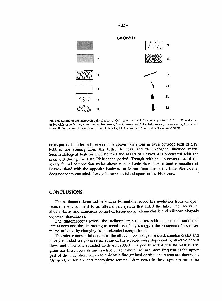
LEGEND
[:=]~
7
82
'"' 9~~~ :~~~::: 3
~~~~
" 10
04. .. ... 5. . .@.' .
. '.' 6. '.
. 11
! 12
Fig. 131. Legend ïß the paleogeographical maps. 1. Continental areas, 2. Preapulian platform, 3. "jsland" freshwateror brackish water basins, 4. marine environments, 5. aci!! intrusives, 6. Cycladic nappe, 7. evaporates, 8. volcanic
zones, 9. fault zones, 10. the front ïß the Hellenides, 11. Volcanoes, 12. vertical tectonic movements.
or as particular interbeds between the above formations or even between beds ïß clay.Pebbles are coming from the tuffs, the lava and the Neogene silicified marls.Sedimentological features indicate that the island ïß Lesvos was connected with themainland during the Late Pleistocene period. Though with the interpretation ïß thescanty faunal composition which shows not endemic characters, a land connection ïßLesvos island with the opposite landmass ïß Minor Asia during the Late Pleistocene,does not seem excluded. Lesvos became an island again ßç the Holocene.
CONCLUSIONS
The sediments deposited ßç í atera Formation record the evolution from an openlacustrine environment to an alluvial fan system that filled the lake. The lacustrine,alluvial-lacustrine sequences consist ïß tenigenous, volcanoclastic and siliceous biogenic
deposits (diatomites).The diatomaceous levels, the sedimentary structures with planar and undulated
laminations and the altemating ostracod assemblages suggest the existence ïß a shallowmarsh affected by changing ßç the chemical composition.
The most common lithofacies ofthe alluvial assemblage are sand, conglomerates andpoorly rounded conglomerates. Some ïß these facies were deposited by massive debÞsflows and show low rounded clasts embedded ßç a poorly sorted detrital matrix. Thegrain size fines upwards and tractive cunent structures are more frequent at the upperpart ïß the unit where silty and epiclastic fine-grained detrital sediments are dominant.Ostracod, vertebrate and macrophyte remains often occur ßç these upper parts ïß the
-33-
õnßé Fossil mammal material collected ßn this part ïß the formation includes a variedmammal assemblage which indicates a Pliocene-Pleistocene age.
ABSTRACT
The present study is a preliminary approach of the first results of the research, whichwas carried out ßç the Vatera area of Lesvos island. It mainly concems the geology andsedimentology of the deposits, which host a rich Middle Villafranchian vertebrate fauna.
The Pre-Neogene substrate of Lesvos island is mainly covered by volcanic rocks ofMiocene-Pliocene age. The geological structure of the island is characterized by thefollowing formations ßç ascending order:a. the autochthonous series of alpine and pre-alpine formations.b. The allochthonous series of alpine formationsc. The unit of postalpine formations.
Éç the broad area between the Cape of Ag. Fokas and Vatera, South Lesvos, thestratigraphical analysis of the Neogene formations showed that at their base, lacustrineorigin and Upper Miocene-Pliocene? marly limestones and diatomites withintercalations of sandstones and tuffites are found.
Two different depositional environments were recognized: a ÉacustÞne environmentßç the lower part and a braided river environment ßç the upper part revealing anevolution from a lacustrine environment to a braided river system that filled the lake.
The diatomaceous levels, the sedimentary structures with planar and undulatedlaminations and the ostracod assemblages suggest the existence of an originally marshenvironment affected by changes of the chemical composition.
Éç areas remote from alluvial sources, especially during periods when alluvial supplywas reduced, sedimentation was dominated by rhythmic diatomaceous mud, with greenand cream couplets forming laminae of millimeter thickness, preserved from bio-turbation by the anoxic environment of the hypolimnion.
ÐÅÑÉËÇØÇ
Ç ðáñïýóá ìåëÝôç áðïôåëåß ìéá ðñþôç ðñïóÝããéóç ôùí ðñþôùí áðïôåëåóìÜôùí ôçòÝñåõíáò ðïõ ðñáãìáôïðïéåßôáé óôçí ðåñéï÷Þ ôùí Âáôåñþí ôçò íÞóïõ ËÝóâïõ. ÁöïñÜêõñßùò ôçí ãåùëïãßá êáé ôçí éæçìáôïëïãßá ôùí áðïèÝóåùí ðïõ qJlëïîåíïýí ìßá ðëïýóéáðáíßäá èçëáóôéêþí çëéêßáò ÌÝóï ÂéëëáöñÜãêéï.
Ôï ðñïíåïãåíÝò õðüâáèñï ôçò íÞóïõ ËÝóâïõ êáëýðôåôáé êõñßùò áðü ç~éóôåéáêÜðåôñþìáôá ÌåéïêáéíéêÞò-ÐëåéïêáéíéêÞò çëéêßáò,
Áíáãíùñßóèçêáí äýï êýñéá áðïèåôéêÜ ðåñéâÜëëïíôá: Ýíá ëéìíáßï ðåñéâÜëëïí óôïêáôþôåñï ôìÞìá êé Ýíá ðëåîïåéäÝò ðïôÜìéï ðåñéâÜëëïí óôï áíþôåñï ôìÞìá ôçò áêï-ëïõèßáò. Óôçí åõñýôåñç ðåñéï÷Þ ìåôáîý ôïõ Áêñùôçñßïõ ôïõ Áã. ÖùêÜ êáé ôùí Âáôå-ñþí, ç óôñùìáôïãñáöéêÞ áíÜëõóç ôùí Íåïãåíþí ó÷çìáôéóìþí êáôÝäåéîå ôçí ýðáñîçëéìíáßáò ðñïåëåýóåùò ìáñãá'ßêþí áóâåóôïëßèùí êáé äéáôïìéôþí ìå åíäéáóôñþóåéò Øáì-ìéôþí êáé ÔÏöqJlôþí.
Ïé äéáôïìéôéêÝò áðïèÝóåéò, ïé éæçìáôïãåíåßò äïìÝò êáèþò êáé ïé ðáíéäéêÝò óõãêå-íôñþóåéò ôùí ïóôñáêùäþí õðïäçëþíïõí ôçí ýðáñîç åíüò âáë ôþäïõò ðåñéâÜëëïíôïò ôï
-34-
ïðïßï åðçñåÜóôçêå áðü ôéò ìåôáâïëÝò óôïí ÷çìéóìü ôùí õäÜôùí.Ïé ðéï êïéíÝò ëéèïöÜóåéò ôùí áëëïõâéáêþí áðïèÝóåùí åßíáé Üììïé, êñïêáëïðáãÞ êáé
êñïêáëïðáãÞ ìå õðïóôñüããõëåò êñïêÜëåò. Ç áêïëïõèßá áõôÞ ãßíåôáé ëåðôïìåñÝóôåñçüóïí,áöïñÜ óôï ìÝãåèïò ôùí êüêêùí ôçò ðñïò ôá åðÜíù. Ç õðÜñ÷ïõóá áðïëéèùìÝíçðáíßäá èTlëáóôéêþí êáôáäåéêíýåé ìéá áíù ðëåéïêáé íéêÔ1 -ðëåéóôïêáé íéêÔ1 Ôéëéêßá.
REFERENCES
BENDA, L. & Ç. DE BRUIJN (1982). Biostratigraphic coðeÉatiïns in the Eastem Mediter-ranean Neogene. 7. Calibration ïß sporomorph- and rodent- associations in the Aliveri-Kymi basin/island ïß Euboea (Greece), Newsletter ßð Stratigraphy, 11/3, 128-135.
BRUIJN DE, Ç. & W.J. ZACHARIASSE (1979). The cïðelatiïn ïß marine and continentalbiozones ïß Kastel1ios Hil1 reconsidered. Ann. Geo/. des Pays Hellen., tome hors serie 1,219-222.
DERMITZAKIS, M.D. & Ç. DRINIA (1999). The presence ïß fossil mamma1s ßç Lesvosisland, ÍÅ Aegean Sea, and their paleobiogeographical implications. Éç: Reumer,J.W.F. & J. de Vos (eds), «Elephants have a snorkel! Papers ßç honour ïß Paul Õ.SondaaD> DEINSEA, 7, 113-120.
DERMITZAKIS, M.D. & Ñ.Õ. SONDAAR (1979). The importance ïß fossil mammalsreconstructing paleogeography, with special reference to the Pleistocene AegeanArchipelago. Ann. Geo/. Pays Hellen., 29, 808-840.
DERMITZAKIS, M.D. (1989). The colonization ïß Aegean islands in relation with thepaleogeographic evolution. Biologia Gallo-hellenica, 14 (2), 99-121.
DERMITZAKIS, M.D. (1996). Paleogeographical evolution ïß the island ïß Lesvos duringLate Cenozoic era. Proceedings of the 1st Symposium for the Petrified Forest of Lesvos,26-27 April1996, 107-114.
DOTSIKA, Å., FYTIKAS, Ì., MOUNTRAKIS, D., PAPAGEORGIOU, F. & Í. ZOUROS(1995). Geothermal exploration in Mytilene area (Lesvos isl. Greece). Proceedings oftheworld geothemzal Congress 1995.2, 989-994.
DOTT, R.H. & J. BOURGEOIS (1982). Hummocky stratification: significance ïß its íaÞabÉebedding sequences. Bul/. Geo/. Soc. Am., 93, 663-689.
GLIOZZI, Å. & É. ÌÁÆÆÉÍÉ (1998). Palaeoenvironmental ana1ysis ïß Early Pleistocenebrackish marshes in the Rieti and Tiberino intrapenninic basins (Latium and Umbria,Italy) using ostracods (Crustacea). Ñá/. Ñá/. Ñá/., 140, 325-333.
GUMUS, Á. (1964). Contribution 1:1 l' etude geologique du secteur septentrional de KalbakKoy-Eymir ÊÏÕ (region d' Edremit) Turquie. Pub/. Maden TektikArama Â, 117,1-109.
HECHT, J. (1972-1975). Geological map ïß Greece 1:50.000, sheets Mithimna, AgiaParaskevi, Eressos, ÑÉ0maÞ-ÌÕtiÉßnß and Polychnitos.
KATSIKATSOS, G., MATARAGAS, D., MIGIROS, G. & Å. TRIANTAFPHYLLIS (1982).Geologica1 study ïß Lesvos Island. I.G.M.E., intemal report, Athens.
KATSIKATSOS, G., MIGIROS, G., TRIANTAFPHYLLIS, Ì. & Á. METTOS (1986).Geological structure ïß the intema1 Hel1inides (East Thessaly - southwest Macedonia,Euboea, Attica, northem Cyclades islands and Lesvos). I.G.M.E., Geology andGeophysical Research, Sp. Issue, 191-212.
MERCIER, J.L., SOREL, D., VERGELY, Ñ. & Ê. SIMEAKIS (1989). Extensional tectonicregimes in the Aegean basins duÞng the Cainozoic. Basin Res., 2, 49-71.
OLTEANU, R. (1975). Ostracoda from DSDP Leg 42Â. DSDP, íïl. 42, 1017-1038.

-35-
PAPAZACHOS, Â., KYRATZI, Á. & Å. PAPADIMITRIOU (1991). Regional focalmechanisms for earthquakes ßn the Aegean area. Pure Áññé. Geophys., 136, 405-420.
PE-PIPER, G. (1978). Caßçozoic volcanic rocks of Lesvos island. Thesis, Univ. ÏÉ Pátrás, ñ.365.ROEGL, F. & F.F. STEININGER (1983). Vom Zerfall der Tethys zu Mediterranen Raumes.
Annálen Náturhistorischen Museum Wien 85Á, 135-163.SCOTCHMAN, I.C. (1991). The geochemistry of concretions from KimmeÞdge Clay Formation
of southern and eastern England. Sedimentology, 38,79-106.SOKAC, Á. (1978). Pleistocene Ostracode fauna of the Pannonian Basin ßn Croatia. Pálaeont.
JugosL, 20, 1-51.SONDAAR, Ñ.Õ. & M.D. DERMITZAKIS (1985). Quaternary insular fossil Mammals and
their paleogeographical implications. Biologiá Gállo-Hellenika, 10, 369-386.SONDAAR, Ñ.Õ., DE VOS, J. & M.D. DERMITZAKIS (1986). Late Cenozoic faunal evo-
lution and Paleogeography of the South Aegean Island Arc. Modem Geology, 10, 249-259.SUSS, Ç. & Å. VELITZELOS (1997). Fossile Ho1zer der FaD!ilie Taxodiaceae aus tertiaren
Schichten des Versteinerten Waldes vïn Lesvos, GÞechenÉand. Feddes Repertorium,108, 1-30.
VELITZELOS, Å. & H.J. GREGOR (1990). Some aspects of the Neogene Floral Historyßn Greece. Review ÏÉ Páláeobotány ánd Pálynology, 62, 291-307.