Embed Size (px)
Citation preview

ai-soluitons.com
AT A GLANCE
Core Functionality:• Spacecraft Propagation
• Coverage & Contact Analysis
• Maneuver Modeling & Targeting
• Orbit Determination
• Attitude Modeling• Attitude Modeling
• Custom Math & Algorithms
• External Interfacing
Heritage:• USAF Programs
• NASA Science Missions
• NOAA Science Missions
• International Space Station• International Space Station
• NASA MPCV
• Commercial Satellite Programs
(U.S. and Abroad)
Operationally Proven For:• Space Situational Awareness
• Orbital Debris/Collision Avoidance
• Ground System Integration• Ground System Integration
• Automated Operations
• Mission Design & Analysis
• Wargame Strategies
• Constellations
Software for Space Mission, Design, Analysis and Operations
SUPPORTING YOUR MISSION FROM THE GROUND UPFreeFlyer provides complete astrodynamics functionality for
missions of any size, any scale, any orbit regime. With
customizable interfaces and cross-platform use, FreeFlyer
supports the full life cycle of your mission.
DESIGNDesign satellite orbits in any regime,define constellation parameters,target maneuvers, and simulate thefull mission life cycle from launch tonominal operations to disposal.
ANALYSISAnalyze any mission requirements,including spacecraft and groundsensor coverages; generate fuelconsumption reports and performparametric trade studies. AugmentFreeFlyer’s internal algorithms withFreeFlyer’s internal algorithms withuser-defined math functions andcustom computations, or use the
OPERATIONSAutomate satellite operations forboth routine and complex flightdynamics tasks and integrationwith ground system databases, 3rdparty TT&C software, and custom /legacy code. Utilize FreeFlyer’s Orbitlegacy code. Utilize FreeFlyer’s OrbitDetermination suite for reliable andaccurate OD solutions.
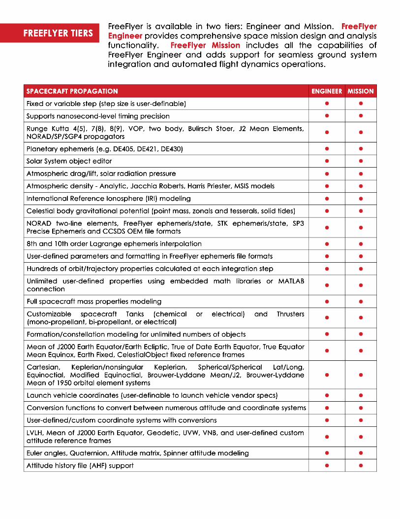
FreeFlyer is available in two tiers: Engineer and MIssion. FreeFlyer Engineer provides comprehensive space mission design and analysis functionality. FreeFlyer Mission includes all the capabilities of FreeFlyer Engineer and adds support for seamless ground system integration and automated flight dynamics operations.
ENGINEER MISSIONSPACECRAFT PROPAGATION
Fixed or variable step (step size is user-definable)
Supports nanosecond-level timing precision
Runge Kutta 4(5), 7(8), 8(9), VOP, two body, Bulirsch Stoer, J2 Mean Elements, NORAD/SP/SGP4 propagators
Planetary ephemeris (e.g. DE405, DE421, DE430)
Solar System object editorSolar System object editor
Atmospheric drag/lift, solar radiation pressure
Atmospheric density - Analytic, Jacchia Roberts, Harris Priester, MSIS models
International Reference Ionosphere (IRI) modeling
Celestial body gravitational potential (point mass, zonals and tesserals, solid tides)
NORAD two-line elements, FreeFlyer ephemeris/state, STK ephemeris/state, SP3 Precise Ephemeris and CCSDS OEM file formats
8th and 10th order Lagrange ephemeris interpolation8th and 10th order Lagrange ephemeris interpolation
User-defined parameters and formatting in FreeFlyer ephemeris file formats
Hundreds of orbit/trajectory properties calculated at each integration step
Unlimited user-defined properties using embedded math libraries or MATLAB connection
Full spacecraft mass properties modeling
CustomizableCustomizable spacecraft Tanks (chemical or electrical) and Thrusters (mono-propellant, bi-propellant, or electrical)
Formation/constellation modeling for unlimited numbers of objects
Mean of J2000 Earth Equator/Earth Ecliptic, True of Date Earth Equator, True Equator Mean Equinox, Earth Fixed, CelestialObject fixed reference frames
Cartesian,Cartesian, Keplerian/nonsingular Keplerian, Spherical/Spherical Lat/Long, Equinoctial, Modified Equinoctial, Brouwer-Lyddane Mean/J2, Brouwer-Lyddane Mean of 1950 orbital element systems
Launch vehicle coordinates (user-definable to launch vehicle vendor specs)
Conversion functions to convert between numerous attitude and coordinate systems
User-defined/custom coordinate systems with conversions
LVLH,LVLH, Mean of J2000 Earth Equator, Geodetic, UVW, VNB, and user-defined custom attitude reference frames
Euler angles, Quaternion, Attitude matrix, Spinner attitude modeling
Attitude history file (AHF) support
FREEFLYER TIERS
ENGINEER MISSION
ENGINEER MISSION
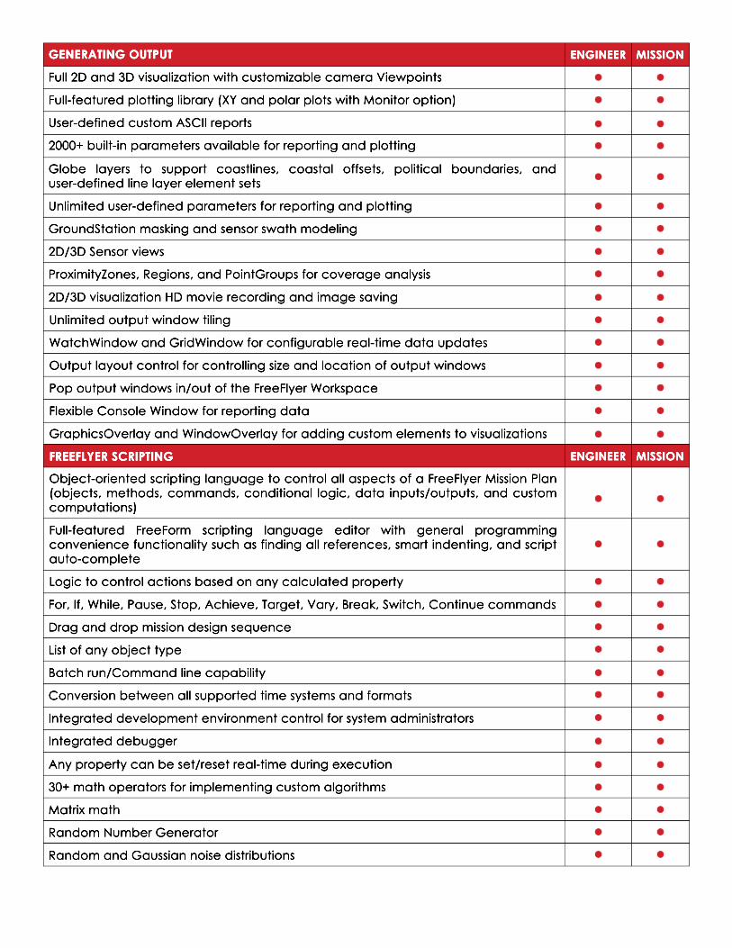
GENERATING OUTPUT
Full 2D and 3D visualization with customizable camera Viewpoints
Full-featured plotting library (XY and polar plots with Monitor option)
User-defined custom ASCII reports
2000+ built-in parameters available for reporting and plotting
GlobeGlobe layers to support coastlines, coastal offsets, political boundaries, and user-defined line layer element sets
Unlimited user-defined parameters for reporting and plotting
GroundStation masking and sensor swath modeling
2D/3D Sensor views
ProximityZones, Regions, and PointGroups for coverage analysis
2D/3D visualization HD movie recording and image saving
Unlimited output window tilingUnlimited output window tiling
WatchWindow and GridWindow for configurable real-time data updates
Output layout control for controlling size and location of output windows
Pop output windows in/out of the FreeFlyer Workspace
Flexible Console Window for reporting data
GraphicsOverlay and WindowOverlay for adding custom elements to visualizations
FREEFLYER SCRIPTING
Object-orientedObject-oriented scripting language to control all aspects of a FreeFlyer Mission Plan (objects, methods, commands, conditional logic, data inputs/outputs, and custom computations)
Full-featured FreeForm scripting language editor with general programming convenience functionality such as finding all references, smart indenting, and script auto-complete
Logic to control actions based on any calculated property
For, If, While, Pause, Stop, Achieve, Target, Vary, Break, Switch, Continue commandsFor, If, While, Pause, Stop, Achieve, Target, Vary, Break, Switch, Continue commands
Drag and drop mission design sequence
List of any object type
Batch run/Command line capability
Conversion between all supported time systems and formats
Integrated development environment control for system administrators
Integrated debugger
Any property can be set/reset real-time during executionAny property can be set/reset real-time during execution
30+ math operators for implementing custom algorithms
Matrix math
Random Number Generator
Random and Gaussian noise distributions
ENGINEER MISSION
ENGINEER MISSION
ENGINEER MISSION
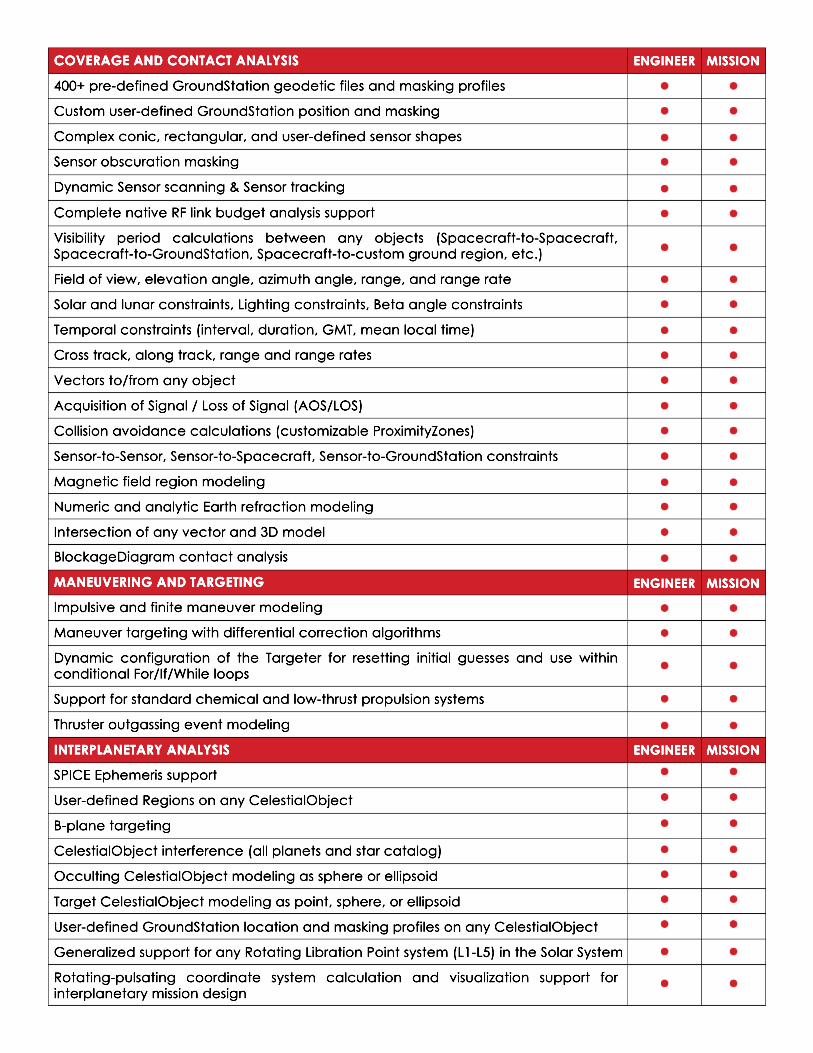
COVERAGE AND CONTACT ANALYSIS
400+ pre-defined GroundStation geodetic files and masking profiles
Custom user-defined GroundStation position and masking
Complex conic, rectangular, and user-defined sensor shapes
Sensor obscuration masking
Dynamic Sensor scanning & Sensor tracking
Complete native RF link budget analysis supportComplete native RF link budget analysis support
Visibility period calculations between any objects (Spacecraft-to-Spacecraft, Spacecraft-to-GroundStation, Spacecraft-to-custom ground region, etc.)
Field of view, elevation angle, azimuth angle, range, and range rate
Solar and lunar constraints, Lighting constraints, Beta angle constraints
Temporal constraints (interval, duration, GMT, mean local time)
Cross track, along track, range and range rates
Vectors to/from any objectVectors to/from any object
Acquisition of Signal / Loss of Signal (AOS/LOS)
Collision avoidance calculations (customizable ProximityZones)
Sensor-to-Sensor, Sensor-to-Spacecraft, Sensor-to-GroundStation constraints
Magnetic field region modeling
Numeric and analytic Earth refraction modeling
Intersection of any vector and 3D model
BlockageDiagram contact analysisBlockageDiagram contact analysis
MANEUVERING AND TARGETING
Impulsive and finite maneuver modeling
Maneuver targeting with differential correction algorithms
Dynamic configuration of the Targeter for resetting initial guesses and use within conditional For/If/While loops
Support for standard chemical and low-thrust propulsion systems
Thruster outgassing event modelingThruster outgassing event modeling
INTERPLANETARY ANALYSIS
SPICE Ephemeris support
User-defined Regions on any CelestialObject
B-plane targeting
CelestialObject interference (all planets and star catalog)
Occulting CelestialObject modeling as sphere or ellipsoid
Target CelestialObject modeling as point, sphere, or ellipsoidTarget CelestialObject modeling as point, sphere, or ellipsoid
User-defined GroundStation location and masking profiles on any CelestialObject
Generalized support for any Rotating Libration Point system (L1-L5) in the Solar System
Rotating-pulsating coordinate system calculation and visualization support for interplanetary mission design
ENGINEER MISSION
ENGINEER MISSION
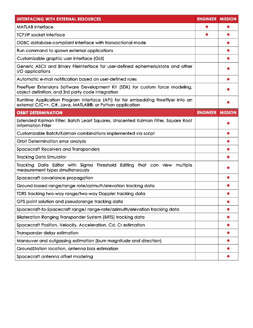
INTERFACING WITH EXTERNAL RESOURCES
MATLAB interface
TCP/IP socket interface
ODBC database-compliant interface with transactional mode
Run command to spawn external applications
Customizable graphic user interface (GUI)
GenericGeneric ASCII and Binary FileInterface for user-defined ephemeris/state and other I/O applications
Automatic e-mail notification based on user-defined rules
FreeFlyer Extensions Software Development Kit (SDK) for custom force modeling, object definition, and 3rd party code integration
Runtime Application Program Interface (API) for for embedding FreeFlyer into an external C/C++, C#, Java, MATLAB®, or Python application
ORBIT DETERMINATIONORBIT DETERMINATION
Extended Kalman Filter, Batch Least Squares, Unscented Kalman Filter, Square Root Information Filter
Customizable Batch/Kalman combinations implemented via script
Orbit Determination error analysis
Spacecraft Receivers and Transponders
Tracking Data Simulator
TrackingTracking Data Editor with Sigma Threshold Editing that can view multiple measurement types simultaneously
Spacecraft covariance propagation
Ground-based range/range rate/azimuth/elevation tracking data
TDRS tracking two-way range/two-way Doppler tracking data
GPS point solution and pseudorange tracking data
Spacecraft-to-Spacecraft range/ range-rate/azimuth/elevation tracking data
Bilateration Ranging Transponder System (BRTS) tracking dataBilateration Ranging Transponder System (BRTS) tracking data
Spacecraft Position, Velocity, Acceleration, Cd, Cr estimation
Transponder delay estimation
Maneuver and outgassing estimation (burn magnitude and direction)
GroundStation location, antenna bias estimation
Spacecraft antenna offset modeling

ENGINEER MISSION
For more information on FreeFlyer® visitwww.ai-solutions.com/freeflyer
or contact us directly:(301) 306-1756 ext. [email protected]
MISCELLANEOUS
Mission Plan Wizards for quick problem setup
150+ Sample Mission Plans included
Customizable Home Screen
Auto-save Mission Plan feature
AvailableAvailable in Windows (FreeFlyer.exe, FF.exe, API, FreeFlyer Extensions, 32- and 64-bit) and Linux (FF.exe, API, 64-bit)
Extensive Help File with all property definitions, syntax, guides, and examples
Dedicated FreeFlyer Technical Support Team available for assistance