Embed Size (px)
Citation preview
www.digitalglobe.com Corporate (U.S.) +1.303.684.4561 or +1.800.496.1225 | London +44.20.3695.0920 | Singapore +65.6389.4851
DATA SHEE T
D ATA P R O D U C T S
Features » High resolution
- 31 cm – 82 cm panchromatic, natural color, color infrared, or 4-band pan sharpened
- 1.64 m – 3.28 m multispectral
» Large image swath collection size - 16.4 km – 18.0 km width at nadir
» High radiometric response - 11-bit digitization (up to 2,048 levels
of gray scale)
- Discrete non-overlapping bands
» Open systems - Camera model information supplied
- Compatible with leading commercial software providers
- Popular image file formats
» Spacecraft telemetry and camera model supplied with satellite imagery
Benefits » Provides the flexibility to perform
your own photogrammetric processing on raw data to produce orthorectified imagery and first generation basemaps
» Identify features, create maps, and detect changes from recent global imagery at the highest resolution possible from commercial imaging satellites
» Map large areas faster with fewer files to manage and process
» Improve feature classification and identification in dark or bright areas, such as building shadows or snow, and perform more flexible image enhancement
» Get your high-resolution satellite orthoimagery project up and running quickly and easily using your existing commercial software
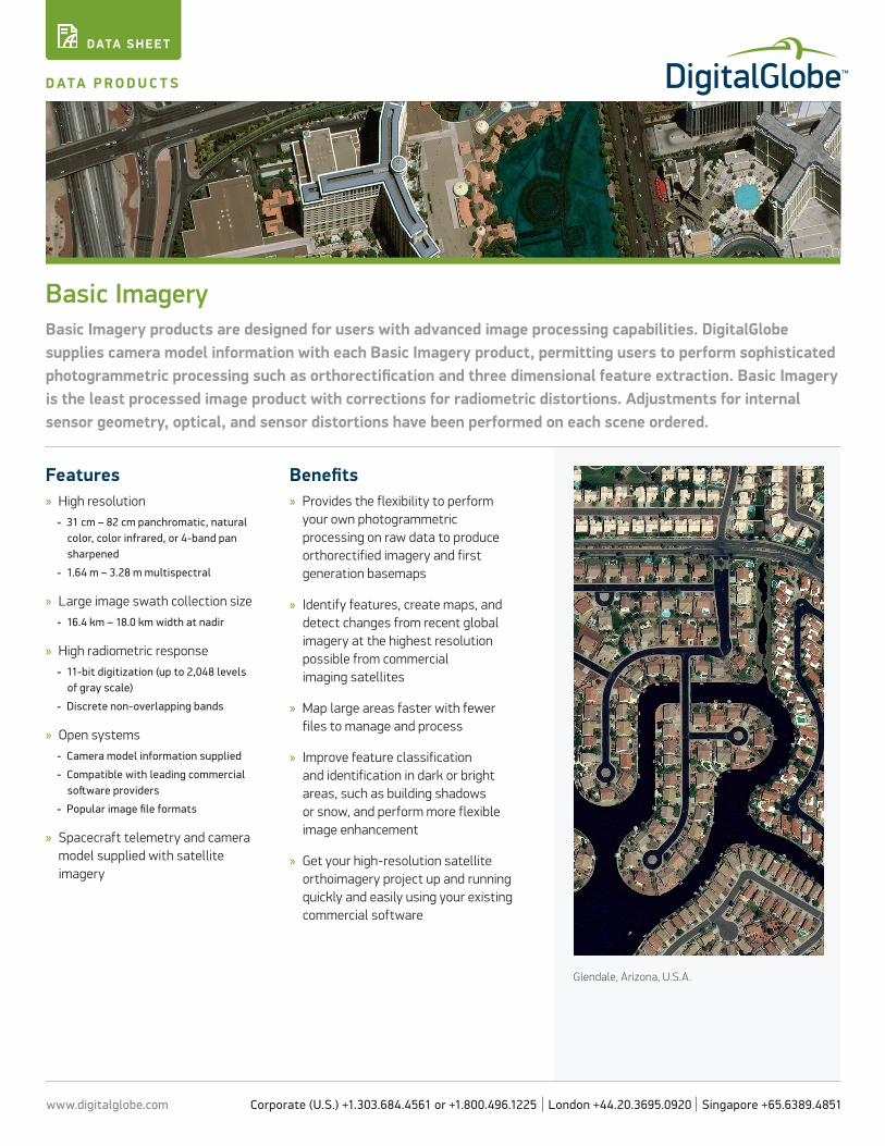
Basic ImageryBasic Imagery products are designed for users with advanced image processing capabilities. DigitalGlobe supplies camera model information with each Basic Imagery product, permitting users to perform sophisticated photogrammetric processing such as orthorectification and three dimensional feature extraction. Basic Imagery is the least processed image product with corrections for radiometric distortions. Adjustments for internal sensor geometry, optical, and sensor distortions have been performed on each scene ordered.
Glendale, Arizona, U.S.A.
www.digitalglobe.com Corporate (U.S.) +1.303.684.4561 or +1.800.496.1225 | London +44.20.3695.0920 | Singapore +65.6389.4851
DATA SHEE T
D ATA P R O D U C T S » B A S I C I M A G E R Y
DS-BASIC 10/16
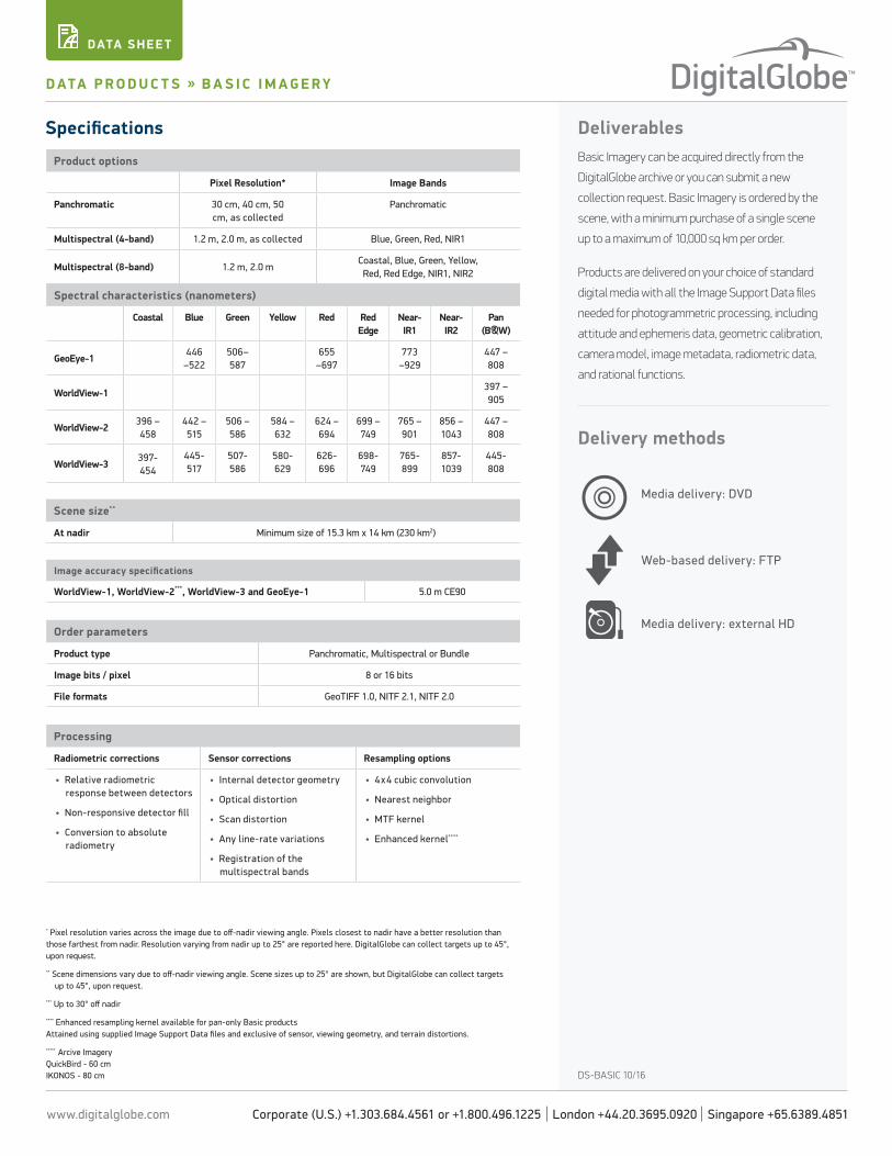
Specifications DeliverablesBasic Imagery can be acquired directly from the
DigitalGlobe archive or you can submit a new
collection request. Basic Imagery is ordered by the
scene, with a minimum purchase of a single scene
up to a maximum of 10,000 sq km per order.
Products are delivered on your choice of standard
digital media with all the Image Support Data files
needed for photogrammetric processing, including
attitude and ephemeris data, geometric calibration,
camera model, image metadata, radiometric data,
and rational functions.
Delivery methods
* Pixel resolution varies across the image due to off-nadir viewing angle. Pixels closest to nadir have a better resolution than those farthest from nadir. Resolution varying from nadir up to 25° are reported here. DigitalGlobe can collect targets up to 45°, upon request.
** Scene dimensions vary due to off-nadir viewing angle. Scene sizes up to 25° are shown, but DigitalGlobe can collect targets up to 45°, upon request.
*** Up to 30° off nadir
**** Enhanced resampling kernel available for pan-only Basic products Attained using supplied Image Support Data files and exclusive of sensor, viewing geometry, and terrain distortions.
***** Arcive Imagery QuickBird - 60 cm IKONOS - 80 cm
Web-based delivery: FTP
Media delivery: DVD
Product options
Pixel Resolution* Image Bands
Panchromatic 30 cm, 40 cm, 50 cm, as collected
Panchromatic
Multispectral (4-band) 1.2 m, 2.0 m, as collected Blue, Green, Red, NIR1
Multispectral (8-band) 1.2 m, 2.0 mCoastal, Blue, Green, Yellow, Red, Red Edge, NIR1, NIR2
Spectral characteristics (nanometers)
Coastal Blue Green Yellow Red Red Edge
Near-IR1
Near-IR2
Pan (B&W)
GeoEye-1446
–522506–587
655 –697
773 –929
447 – 808
WorldView-1397 – 905
WorldView-2396 – 458
442 – 515
506 – 586
584 – 632
624 – 694
699 – 749
765 – 901
856 – 1043
447 – 808
WorldView-3397-454
445-517
507-586
580-629
626-696
698-749
765-899
857-1039
445-808
Scene size**
At nadir Minimum size of 15.3 km x 14 km (230 km2)
Image accuracy specifications
WorldView-1, WorldView-2***, WorldView-3 and GeoEye-1 5.0 m CE90
Order parameters
Product type Panchromatic, Multispectral or Bundle
Image bits / pixel 8 or 16 bits
File formats GeoTIFF 1.0, NITF 2.1, NITF 2.0
Processing
Radiometric corrections Sensor corrections Resampling options
• Relative radiometric response between detectors
• Non-responsive detector fill
• Conversion to absolute radiometry
• Internal detector geometry
• Optical distortion
• Scan distortion
• Any line-rate variations
• Registration of the multispectral bands
• 4x4 cubic convolution
• Nearest neighbor
• MTF kernel
• Enhanced kernel****
Media delivery: external HD