Embed Size (px)
Citation preview
GGoovveerrnnmmeenntt ooff tthhee RReeppuubblliicc ooff MMaallaawwii
MMiinniissttrryy ooff AAggrriiccuullttuurree aanndd FFoooodd SSeeccuurriittyy
IIrrrriiggaattiioonn,, RRuurraall LLiivveelliihhooooddss aanndd AAggrriiccuullttuurraall DDeevveellooppmmeenntt PPrroojjeecctt
EEnnvviirroonnmmeennttaall aanndd SSoocciiaall IImmppaacctt AAsssseessssmmeenntt aanndd MMaannaaggeemmeenntt PPllaann
((EESSIIAA//EESSMMPP))
BBIIKKIINNAANNII IIRRRRIIGGAATTIIOONN SSCCHHEEMMEE ((ZZoommbbaa DDiissttrriicctt))
CCoonnttrraacctt NNuummbbeerr:: 001199//IIRRLLAADD//PPRROO//0066//33//22000077::
SSUURRVVEEYY,, DDEESSIIGGNN AANNDD PPRREEPPAARRAATTIIOONN OOFF BBIIDDDDIINNGG DDOOCCUUMMEENNTTSS FFOORR TTHHEE CCOONNSSTTRRUUCCTTIIOONN OOFF NNEEWW SSMMAALLLL SSCCAALLEE IIRRRRIIGGAATTIIOONN SSCCHHEEMMEESS IINN CCEENNTTRRAALL AANNDD
SSOOUUTTHHEERRNN RREEGGIIOONNSS
May 2009
AAggrriiccaannee MMaallaawwii LLttdd iinn AAssssoocciiaattiioonn wwiitthh SSSSII EEnnvviirroonnmmeennttaall aanndd CCoonnssuullttiinngg EEnnggiinneeeerrss NNcchhaalloo OOffffiicceess –– OOppppoossiittee NNcchhaalloo FFaaccttoorryy
PP..OO.. BBooxx 8866 NNcchhaalloo PPhhoonnee//FFaaxx:: 0011442255336655
Pub
lic D
iscl
osur
e A
utho
rized
Pub
lic D
iscl
osur
e A
utho
rized
Pub
lic D
iscl
osur
e A
utho
rized
Pub
lic D
iscl
osur
e A
utho
rized
Pub
lic D
iscl
osur
e A
utho
rized
Pub
lic D
iscl
osur
e A
utho
rized
Pub
lic D
iscl
osur
e A
utho
rized
Pub
lic D
iscl
osur
e A
utho
rized
2
EXECUTIVE SUMMARY
This document is an Environmental and Social Impact Assessment Report with accompanying Management and Monitoring Plan (ESMP) for a proposed Bikinani irrigation Scheme in Zomba District in Southern Malawi. It is a strategic tool that will guide implementation of the project in order to maximise socio-economic benefits whilst minimising adverse environmental and social effects that may arise from the project implementation. Bikinani Irrigation Scheme site is situated close to Zomba Mountain along Namitembo River in Chingale EPA in Zomba District. The project area being at the foothills of Zomba Mountain has a terrain characterised by gentle to steep slopes which are intensively cultivated by communities. The project site, which is approximately 50 ha of land area, includes part of an existing scheme of approximately 5 ha which was developed with support from the World Vision International. Implementation of the project shall involve a number of activities which shall include:-
Construction of a stone masonry weir, Construction of distribution canals for irrigation water, Construction of storm drains and flood protection structures, Construction of a storage reservoir for irrigation water, Demarcation of the project site into agricultural plots and: Construction of access roads for the scheme.
It is envisaged that project activities both during the construction and operational phases will have both positive and negative impacts on the environment. The positive impacts shall include, amongst others:-
Improvement of the socio-economic life of the farmers in the area through enhanced food security and access to income,
Gain of knowledge and skills related to agriculture and land resources management by farmers
Improvement in the ecosystem management of Namitembo River
Potential negative impacts, on the other hand, will include, amongst others:- Reduced water quantities in Namitembo River due to irrigation water abstraction, Surface and groundwater & soil pollution due to agricultural chemical inputs, crop failure due to soil salinisation and excessive nutrient loss, increased water borne and water vectored diseases, and: Occupational safety incidents for construction workers.
This Environmental and Social Management and Monitoring Plan has prescribed a number of mitigation measures for addressing the negative impacts and enhancing the positive impacts. Furthermore, the plan has made recommendations on responsible authorities for effective implementation of the proposed measures. Most of the measures will be implemented through out the project lifecycle. In conclusion, this Environmental and Social Management and Monitoring Plan has provided recommendations to the implementing and monitoring stakeholders aimed at ensuring that the benefits of this plan are realised. Overall, these recommendations have emphasised that unless the ecosystem of Namitembo River is properly managed and proper agricultural/land conservation practices are employed by farmers at all times, the sustainability of the scheme will be compromised and the benefits will not be realised as expected.
3
TABLE OF CONTENTS 1.0 INTRODUCTION AND BACKGROUND INFORMATION ----------------------------------------------- 5
1.1 Introduction ------------------------------------------------------------------------------------------------------- 5 1.2 Main Objective of the Environmental and Social Management Plan (ESMP) ------------------- 5 1.3 Structure of the Report ---------------------------------------------------------------------------------------- 5
2. PROJECT AND BIO-PHYSICAL DESCRIPTION ------------------------------------------------------------ 6 2.1 Location and bio-physical description of the project site ---------------------------------------------- 6 2.2 Main objective of the project --------------------------------------------------------------------------------- 6 2.3 Main activities to be undertaken during the project life cycle ---------------------------------------- 6
3.0 METHODOLOGY FOR DATA COLLECTION -------------------------------------------------------------- 9 3.1 Field Survey ------------------------------------------------------------------------------------------------------ 9 3.2 Stakeholder Consultation ------------------------------------------------------------------------------------- 9 3.3 Literature Review ----------------------------------------------------------------------------------------------- 9
4. DESCRIPTION OF THE BIOLOGICAL, PHYSICAL AND SOCIO -ECONOMIC ENVIRONEMENT --------------------------------------------------------------------------------------------------------- 10
4.1. Physical environment ---------------------------------------------------------------------------------------- 10 4.2. Biological environment -------------------------------------------------------------------------------------- 15 4.3 Social and economic environment ------------------------------------------------------------------------ 15 4.4 Baseline Data -------------------------------------------------------------------------------------------------- 16
5. DETERMINED ENVIRONMENTAL AND SOCIAL IMPACTS ------------------------------------------- 17 5.1 Potential Positive Environmental Impacts -------------------------------------------------------------- 17 5.2 Potential Negative Environmental Impacts ------------------------------------------------------------- 17 5.3 Potential Positive Social Impacts ------------------------------------------------------------------------- 17 5.4 Potential Negative Social Impacts ------------------------------------------------------------------------ 18 5.5 Level of severity of Different Impacts. ------------------------------------------------------------------- 18 5.6 Suggested mitigation measures to overcome Potential Negative Environmental and Social Impacts ------------------------------------------------------------------------------------------------------------------- 18
6 ENVIRONMENTAL AND SOCIAL MANAGEMENT AND MONITORING PLANS ----------------- 20 6.1 ESMP ---------------------------------------------------------------------------------------------------------------- 20 6.2 Contractor Obligations under the ESMP -------------------------------------------------------------------- 20 6.3. Beneficiary Obligations under the ESMP ------------------------------------------------------------------ 20 6.4 Estimated Budget for the ESMP ------------------------------------------------------------------------------ 20 6.5 Monitoring Plan ---------------------------------------------------------------------------------------------------- 21 6.6 Environmental Audit Plan --------------------------------------------------------------------------------------- 21 6.7 Estimated Costs for Monitoring ------------------------------------------------------------------------------- 21
7 CONCLUSIONS AND RECOMMENDATIONS ------------------------------------------------------------- 32 ANNEXE 1: List of Stakeholders Consulted During the Assessment ---------------------------------------- 34
4
List of Acronyms
ADD Agricultural Development Division ADMARC Agricultural Development and Marketing Corporation AEDC Agriculture Extension Development Coordinator AEDO Agriculture Extension Development Officer BoQ Bills of Quantities DAES Department of Agricultural Extension Services DAO District Agriculture Office (ex-RDP Rural Development Project) DANIDA Danish International Development Agency DIASU District Irrigation Advisory Services Unit DIO District Irrigation Office DoI Department of Irrigation DTM Digital Terrain Model EC Electrical Conductivity EIA Environmental Impact Assessment EMA Environment Management Act (1996) EMP Environmental Management Plan EPA Extension Planning Areas FAO Food and Agriculture Organisation GoM Government of Malawi GPS Global Positioning System GRP Glass Reinforced Pipe HIPC Heavily Indebted Poor Countries IFAD International Food and Agriculture Development IRLADP Irrigation, Rural Livelihood and Agricultural Development Project IWMU Irrigation Water Management Unit MoAFS Ministry of Agriculture and Food Security MoIWD Ministry of Irrigation and Water Development NEAP National Environment Action Plan (1994) NEP National Environment Policy (1996) NGO Non-Governmental Organisations NIPDS National Irrigation Policy and Development Strategy (2000) PCU Project Coordination Unit PM Programme Manager SMC Scheme Management Committee SM Scheme Manager TBM Temporary Bench Mark ToR Terms of Reference WB World Bank WUA Water Users’ Association
5 ESIA - Bikinani Scheme
1.0 INTRODUCTION AND BACKGROUND INFORMATION
1.1 Introduction
This document is an Environmental and Social Impact Assessment with associated Management and Monitoring Plan (ESMP) for a proposed Bikinani irrigation Scheme in Zomba District in Southern Malawi under the IRLAD Project. It is a strategic tool that will guide implementation of the project in order to maximise socio-economic benefits whilst minimising adverse environmental and social effects that may arise from the project implementation. Effective implementation of this ESMP will be dependent on concerted efforts by concerned stakeholders throughout the project life span in order to sustain the expected benefits and avoid a decline in environmental quality. Resources will be required either from the project funds or other auxiliary projects for the implementation of various mitigation and enhancement measures.
1.2 Main Objective of the Environmental and Social Management Plan (ESMP)
The main objective of this Environmental and Social Management and Monitoring Plan is to identify potential environmental and social impacts, both negative and positive; analyse them and propose preferred measures for mitigating the negative impacts at various stages of the project. Furthermore, the plan recommends appropriate institutions as responsible authorities for the implementation and monitoring of the management plan. The ESMP has been prepared in accordance with the Environmental Impact Assessment Guidelines for Irrigation and Drainage Projects (2002) from the Environmental Affairs Department.
1.3 Structure of the Report
This ESMP is organised into 7 sections. Section 1. provides the introductory information to the document, including the objectives of the management and monitoring plan. Section 2. outlines the main objective of the project, its location and bio-physical attributes, including the main project activities to be implemented. Section 3 provides an outline of the methodology for data collection and analysis during the development of this ESMP while Section 4 provides information on scheme physical and social characteristics. Section 5 outlines the environmental and social impacts of the project, both negative and positive, including the impact-severity matrix for negative impacts. Section 6 contains the environmental and social management and monitoring plans in tabulated format. Finally, the conclusions and recommendations of the ESMP are presented in Section 7 of the document. The Annexe of the document has a list of stakeholder consulted.
6 ESIA - Bikinani Scheme
2. PROJECT AND BIO-PHYSICAL DESCRIPTION
2.1 Location and bio-physical description of the project site
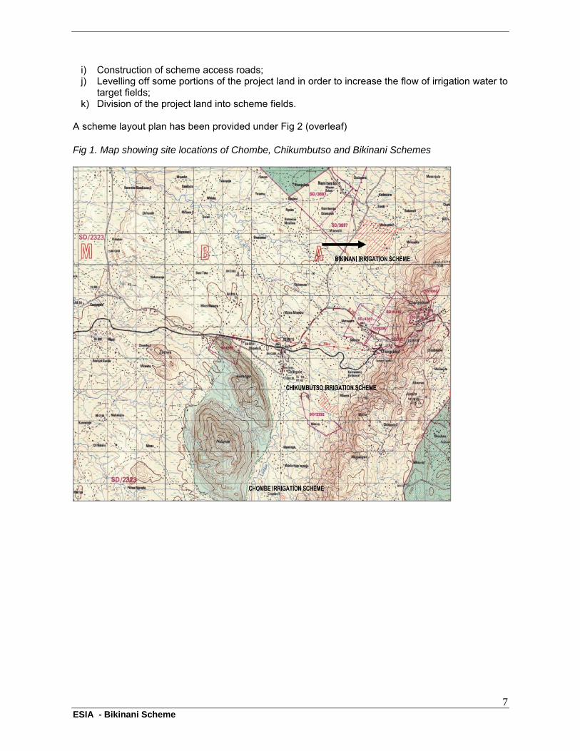
Bikinani Irrigation Scheme site is situated close to Zomba Mountain along Namitembo River in Chingale EPA in Zomba District. A location map has been included in Fig 1. (overleaf). The project area, being at the foothills of Zomba Mountain, has a terrain characterised by gentle to steep slopes which are intensively cultivated by communities. The project site includes part of an existing irrigation scheme of approximately 5 ha which was developed with support from the World Vision International. The intake point for the existing scheme consists of a temporary weir from which water is diverted into a hand dug earth lined delivery canal that feeds graded furrows for subsequent water distribution into the fields. The current scheme arrangement has a potential for expansion to the proposed 40 to 50 ha of land on both sides of Namitembo River. The project site is customary land, under cultivation and predominantly surrounded by villages and agricultural land. The catchment area of the source of irrigation water (i.e Namitembo River) is under approximately 75% cultivation on the steep slopes stretching towards the river source. The source area is wooded with Miombo woodland at present. Crops that are currently being cultivated on the project site and surrounding agricultural land include maize, pigeon peas, beans and vegetables, amongst others. It is expected that scheme beneficiaries will continue cultivating the same types of crops though there is a probability of diversifying into other crop types such as paprika, Irish potato, sweet potato, high value vegetables, fruit crops and other tree fruit crops , where appropriate.
2.2 Main objective of the project
The main objective of the proposed Bikinani Irrigation Scheme project is to upgrade the existing scheme into an area of approximately 50 ha suitable for irrigation from the current 5 ha and thus increasing the number of beneficiaries and the capacity of the existing farmers to produce more. The ultimate goal of the project therefore is to enhance the socio-economic status of the people in the area through increased food security and income by promoting improved agricultural practices without compromising environmental quality.
2.3 Main activities to be undertaken during the project life cycle
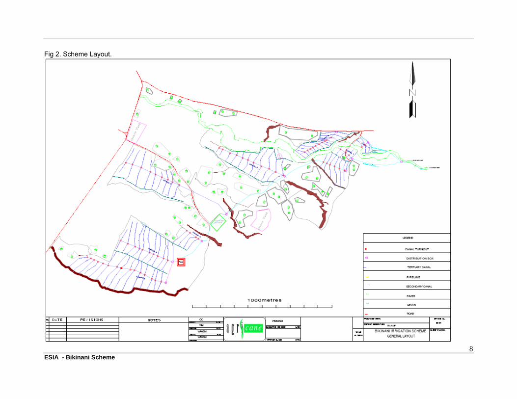
The main project activities for Bikinani Irrigation Scheme shall include the following:- a) Construction of a short and wide stone masonry weir from which a conveyance pipe of 140
mm in diameter will deliver water into the main supply canal over a distance of about 100 metres;
b) Construction of concrete or masonry pillars to support the conveyance pipe; c) Construction of an earth embankment Night Storage Reservoir (NSR) for irrigation water with
a storage capacity of 3.72 Megalitres. The NSR will have brick or stone masonry inlet, outlet and a spillway;
d) Construction of stone masonry lined main supply canals amounting to 645 metres; e) Construction of a number of brick lined secondary distribution canals amounting to 2351
metres; f) Construction of earth lined feeder canals amounting to 15,000 metres; g) Construction of earth lined open drains amounting to 3300 metres for removal of excess water
and cut-off drains amounting to 400 metres to protect the main supply canal and NSR from surface runoff effects;
h) Construction of approximately 110 drop fall and turn out distribution boxes with control gates amongst the network of feeder canals;
7 ESIA - Bikinani Scheme
i) Construction of scheme access roads; j) Levelling off some portions of the project land in order to increase the flow of irrigation water to
target fields; k) Division of the project land into scheme fields.
A scheme layout plan has been provided under Fig 2 (overleaf) Fig 1. Map showing site locations of Chombe, Chikumbutso and Bikinani Schemes
8 ESIA - Bikinani Scheme
Fig 2. Scheme Layout.
9 ESIA - Bikinani Scheme
3.0 METHODOLOGY FOR DATA COLLECTION
A number of methods for data collection were employed during the development of this ESMP; however the main ones include field survey through site observations, stakeholder consultations through interviews and focus group discussions; and literature review.
3.1 Field Survey
A number of field visits were conducted to the project site in Chingale EPA, Zomba during the period May 2008 to December 2008 in the process of preparing detailed designs for the proposed irrigation scheme. Specific discussions relating to this ESIA were held on 19th December 2008 and 18th January 2009. The outcome of these visits as well as observations from other experts has been used to characterize the bio-physical components of the environment including ecological regime of the surrounding surface waters, especially Namitembo River, current land use practices on and around the project site, the type of water demanding uses that may compete with the irrigation project, the topography of the area, presence and sufficiency of sanitary hardware including latrines and sources of potable water.
3.2 Stakeholder Consultation
A number of stakeholders were consulted during data collection; including direct beneficiaries as well as the government departments’ personnel that had and will have a direct stake in the planning and implementation of the project. The personnel consulted were therefore from the Ministry of Irrigation & Water Development (District Irrigation Advisory Service Unit) and the Ministry of Agriculture and Food Security. Direct interviews and focus group discussions were the main methods that were used to capture information from these stakeholders.
3.3 Literature Review
Most of the information used in this ESMP came from field work and design data and not form published and unpublished literature. The information used includes bio-physical parameters like water and soil quality, climatic conditions, topographic attributes of the area, flora and fauna, and demographic statistics, all of which were used to derive preferred mitigation and enhancement measures for the identified impacts of the project.
10 ESIA - Bikinani Scheme
4. DESCRIPTION OF THE BIOLOGICAL, PHYSICAL AND SOCIO -ECONOMIC ENVIRONEMENT
4.1. Physical environment
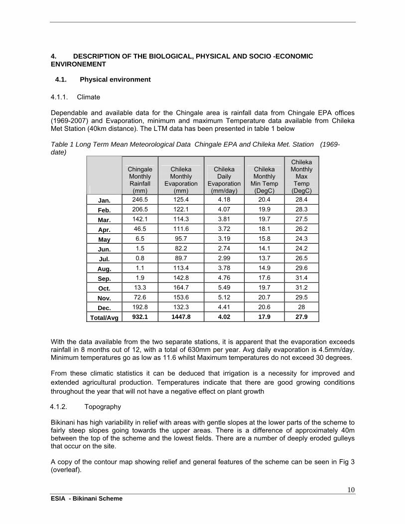
4.1.1. Climate Dependable and available data for the Chingale area is rainfall data from Chingale EPA offices (1969-2007) and Evaporation, minimum and maximum Temperature data available from Chileka Met Station (40km distance). The LTM data has been presented in table 1 below Table 1 Long Term Mean Meteorological Data Chingale EPA and Chileka Met. Station (1969-date)
Chingale Monthly Rainfall (mm)
Chileka Monthly
Evaporation (mm)
Chileka Daily
Evaporation (mm/day)
Chileka Monthly
Min Temp (DegC)
Chileka Monthly
Max Temp
(DegC)
Jan. 246.5 125.4 4.18 20.4 28.4
Feb. 206.5 122.1 4.07 19.9 28.3
Mar. 142.1 114.3 3.81 19.7 27.5
Apr. 46.5 111.6 3.72 18.1 26.2
May 6.5 95.7 3.19 15.8 24.3
Jun. 1.5 82.2 2.74 14.1 24.2
Jul. 0.8 89.7 2.99 13.7 26.5
Aug. 1.1 113.4 3.78 14.9 29.6
Sep. 1.9 142.8 4.76 17.6 31.4
Oct. 13.3 164.7 5.49 19.7 31.2
Nov. 72.6 153.6 5.12 20.7 29.5
Dec. 192.8 132.3 4.41 20.6 28
Total/Avg 932.1 1447.8 4.02 17.9 27.9
With the data available from the two separate stations, it is apparent that the evaporation exceeds rainfall in 8 months out of 12, with a total of 630mm per year. Avg daily evaporation is 4.5mm/day. Minimum temperatures go as low as 11.6 whilst Maximum temperatures do not exceed 30 degrees. From these climatic statistics it can be deduced that irrigation is a necessity for improved and extended agricultural production. Temperatures indicate that there are good growing conditions throughout the year that will not have a negative effect on plant growth
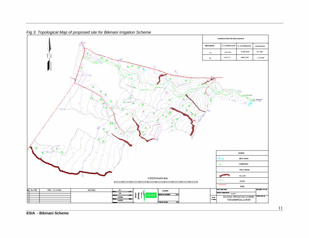
4.1.2. Topography Bikinani has high variability in relief with areas with gentle slopes at the lower parts of the scheme to fairly steep slopes going towards the upper areas. There is a difference of approximately 40m between the top of the scheme and the lowest fields. There are a number of deeply eroded gulleys that occur on the site. A copy of the contour map showing relief and general features of the scheme can be seen in Fig 3 (overleaf).
11 ESIA - Bikinani Scheme
Fig 3. Topological Map of proposed site for Bikinani Irrigation Scheme
12 ESIA - Bikinani Scheme
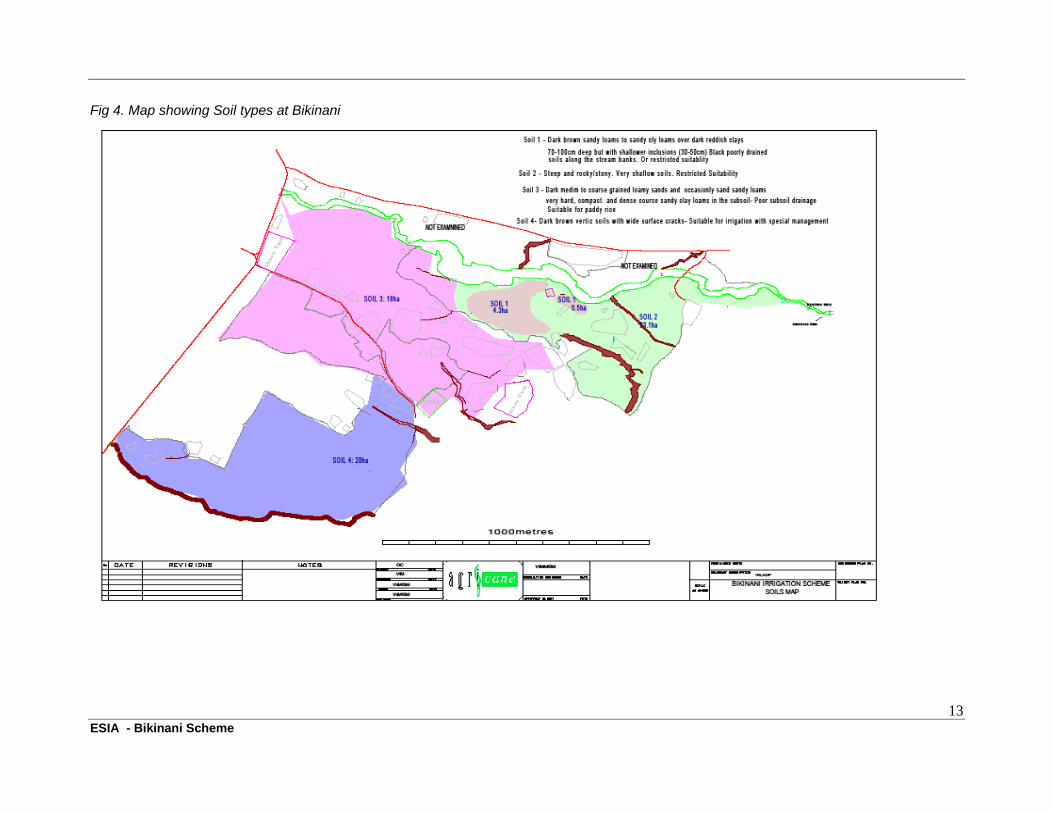
4.1.3. Soils The scheme has been described as two blocks, Block A being the first block identified for scheme development; and Block B being the second area identified for development by beneficiaries. Descriptions of these soils are presented below and shown graphically in Fig 4 (overleaf). a) Soils of Block A
The basement geology of the area is dolerite. Accordingly all areas of in situ derived soils at the site are derived from dolerite. These soils consist of: Soil Type 1A:- This soils are 70 – 100cm deep medium grained sandy clay loams to clays overlying dark reddish brown clays of good internal drainage in the subsoil, which in turn overlie weathering rock. Within the blocks of 70 – 100cm deep soils, there are common inclusions of shallower (30-50cm) patches of soils as well as small areas of rock outcrops; Soil Type 2A:- Soils derived in situ from dolerite but located on steep slopes where full profile expression has not been possible. These soils on steep slopes are very shallow, rocky or stony. The area is has limited suitability for irrigation on account of their shallow depth and the steep topography of the land where they occur. Along the river soils derived from dolerite are influenced by periodic waterlogging and have darker surface colours with subsoil variegation and yellow mottles. They are moderately poorly drained, subject to periodic waterlogging. These lands are very small and it was not possible to map the soils at the scale employed. They are of restricted suitability for irrigation on account of their proneness to waterlogging. Soils of Block A, are slightly acid with pH values in the 4.8 – 5.0 range, which is a little low for most crops. An application of lime at a rate of at least 200 kg per ha is recommended initially, with regular monitoring of soil pH being necessary for further corrective liming if necessary. The phosphate level of less than 10 ppm in the soil samples collected for this soil type indicates a need for a high initial application of phosphate to raise the level to at least 15ppm. This can be achieved through an application of compound fertilizer or superphosphate, with a target of applying at least 30kg of P per ha.. The soils are also low in nitrogen and any irrigated crop will need an initial application of 25kg N/ha followed by a second application of at least 35kg N/ha. b) Soils of Block B
Block B contains a more contiguous area of soils that are more suitable for irrigation, where the soils are on topographically suitable land (flat gradients). In this block, the two main soil types are: Soil Type 1B: Dark medium to coarse grained loamy sands and occasionally sandy loams abruptly changing to very hard compact and dense coarse sandy clay loams and sandy clays. These soils are suspected to be sodic pending the return of soils analysis results. These soils are more suitable for paddy rice on account of their poor subsoil drainage and not for most normal field crops. Soil Type 2B: The second soils consists of dark brown vertic clays with wide surface cracks, indicating a higher than normal clay %. There are signs of mottling in the sub-soil which indicates that the soils may become water logged during the rainy season. These soils are relatively deep and will be suitable for irrigation provided there is sufficient drainage with careful management (such as regular maintenance of drainage network, recycling or organic matter, appropriate irrigation scheduling etc..
13 ESIA - Bikinani Scheme
Fig 4. Map showing Soil types at Bikinani
14 ESIA - Bikinani Scheme
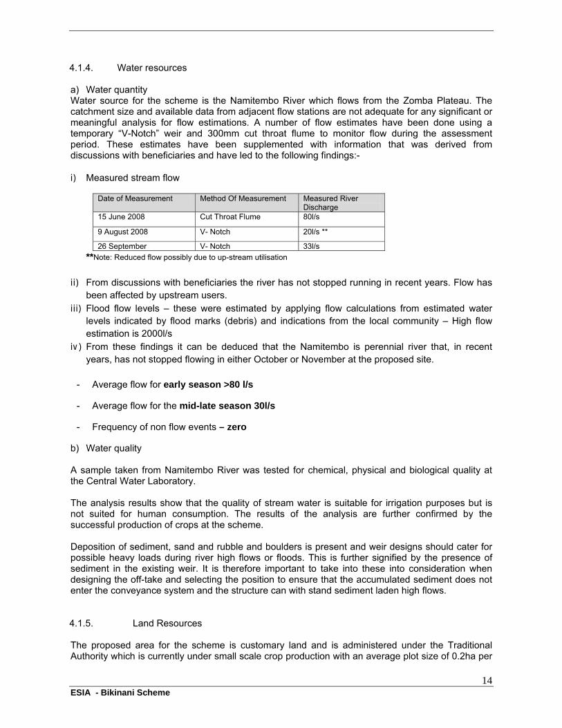
4.1.4. Water resources a) Water quantity Water source for the scheme is the Namitembo River which flows from the Zomba Plateau. The catchment size and available data from adjacent flow stations are not adequate for any significant or meaningful analysis for flow estimations. A number of flow estimates have been done using a temporary “V-Notch” weir and 300mm cut throat flume to monitor flow during the assessment period. These estimates have been supplemented with information that was derived from discussions with beneficiaries and have led to the following findings:- i) Measured stream flow
Date of Measurement Method Of Measurement Measured River Discharge
15 June 2008 Cut Throat Flume 80l/s
9 August 2008 V- Notch 20l/s **
26 September V- Notch 33l/s
**Note: Reduced flow possibly due to up-stream utilisation
ii) From discussions with beneficiaries the river has not stopped running in recent years. Flow has
been affected by upstream users. iii) Flood flow levels – these were estimated by applying flow calculations from estimated water
levels indicated by flood marks (debris) and indications from the local community – High flow estimation is 2000l/s
iv) From these findings it can be deduced that the Namitembo is perennial river that, in recent years, has not stopped flowing in either October or November at the proposed site.
- Average flow for early season >80 l/s
- Average flow for the mid-late season 30l/s
- Frequency of non flow events – zero
b) Water quality A sample taken from Namitembo River was tested for chemical, physical and biological quality at the Central Water Laboratory. The analysis results show that the quality of stream water is suitable for irrigation purposes but is not suited for human consumption. The results of the analysis are further confirmed by the successful production of crops at the scheme. Deposition of sediment, sand and rubble and boulders is present and weir designs should cater for possible heavy loads during river high flows or floods. This is further signified by the presence of sediment in the existing weir. It is therefore important to take into these into consideration when designing the off-take and selecting the position to ensure that the accumulated sediment does not enter the conveyance system and the structure can with stand sediment laden high flows. 4.1.5. Land Resources The proposed area for the scheme is customary land and is administered under the Traditional Authority which is currently under small scale crop production with an average plot size of 0.2ha per
15 ESIA - Bikinani Scheme
farmer. Scheme members “rent” land from the land owners during irrigating season only. The land owners then cultivate the land during the rainy season. Most land owners (but not all) are members of the scheme. Under IRLADP, the intention is to formalise the land ownership under the WUA. This is regarded as an essential step that will ensure long term sustainability of the scheme.
4.2. Biological environment
4.2.1 Vegetation and Flora Apart from small pockets of natural vegetation, the project area has been cleared for agricultural activity which has left very little natural or planted vegetation. 4.2.2 Fauna No large wildlife mammal species was reported for this site. The main types of large fauna found in the area are domestic animals such as cattle, sheep, goats, pigs and poultry. Observations were made of numerous indigenous bird, reptile (lizards, snakes, frogs) and insects in and around the site. 4.2.3 Riverine Ecosystem The source of the river is within the Zomba Forest Reserve (outer slopes) which has partly indigenous montane evergreen forest and partly planted forests (pine and eucalyptus). As the river flows out of the forest reserve the riverine ecosystem is heavily degraded with stretches of river bank that have been intensely cultivated with very few trees and other vegetation remaining. There are signs of heavy erosion along the river bank. There is an urgent need to rehabilitate and conserve the river banks.
4.3 Social and economic environment
4.3.1 Scheme Membership and Organisational Structure Most existing and anticipated beneficiaries come from Bikinani 1 village. There are a total of 96 scheme members as heads of households of which 33 are men and 63 are women. Registration of new members in anticipation of the new scheme has started and at least 200 hundred members have been registered.
4.3.2 Social Infrastructure around the Scheme a) Health Facilities The closest health facility is Chingale Health Centre at Chingale (approx 15km). The closest hospital is in Zomba being Zomba District Hospital (approx 35km). b) Education Facilities There are two schools at Chingale, namely Chingale Full Primary School and Chingale Community Day Secondary School (CDSS) both at a distance of approximately 15km from the project site. Other schools are found at Thondwe and in Zomba Town (approx 35km). c) Domestic Water Supply There are a number of boreholes with manual pumps which are used by the community for drinking water. Water from the river is used for washing and bathing. d) Electricity Supply
16 ESIA - Bikinani Scheme
There is no electricity supply to the site; however there is a HT mainline that passes the scheme along the main road towards the Chingale quarry (approx 1km distance). Chingale itself also has electricity power supply (approx 15km). e) Sanitation Communities make use of traditional pit latrines for sanitation. All latrines are located near the areas where houses have been built.
4.3.3 Access Roads There is a dirt road which access the site. The road is handmade and requires alot of maintenance. The scheme can be access from either Chingale which is accessed from the M5 (Blantyre – Zomba)or from the north (Liwonde-Machinga-Zomba)).Both are dirt roads that deteriorate during the rainy season. 4.3.4 Telecommunications There is coverage of both TNM and ZAIN in the area, however, this is limited in some areas due to lack of coverage.
4.4 Baseline Data
Samples and data collected for the designs are not sufficient to provide a full baseline data set against which the scheme’s environmental performance can be gauged. It is therefore important that a number of baseline surveys are conducted during the first year. These include:-
Collection of detailed river water discharge levels Collection of additional water samples for quality analysis Assessment of riverine indicator species Collection of additional soil samples for chemical and physical analysis Collection of social information on land tenure and land use arrangements
The estimated costs have been included in the ESMP costs (see section 6.2).
17 ESIA - Bikinani Scheme
5. DETERMINED ENVIRONMENTAL AND SOCIAL IMPACTS
There are several environmental and social impacts, both negative and positive, that the project will effect and will experience that will require mitigation and enhancement measures at various phases of the project.
5.1 Potential Positive Environmental Impacts
These include but not limited to: i. Opportunity for employment and skills development during the construction stages ii. Enhancement of biodiversity conservation practices in the catchment area of Namitembo River; iii. Restoration of Namitembo riverine ecology; iv. Promotion of land resources conservation practices amongst farmers in the area; v. Recharge of underground aquifers; vi. Enhancement of habitats for wildlife due to increased vegetative cover along Namitembo River
as a result of riverine afforestation initiatives;
5.2 Potential Negative Environmental Impacts
5.2.1 Construction Phase These include but not limited to the following: i. Ground and surface water pollution due to construction debris ii. Disturbance and loosening of soils during excavations of irrigation water ways & water
storage reservoirs, construction of scheme access roads and land levelling/preparation; iii. Air pollution due to dust emissions during the construction phase
5.2.2 Operational Phase These include but not limited to the following:
i. Degradation of aquatic life downstream of the intake point due to a decrease in water quantities
(requires maintenance of minimum environmental flow) ii. Loss of nutrients due to soil erosion and leaching as a result of over-cultivation and irrigation; iii. Soil salinisation due to water logging and persistent chemical input during cultivation; iv. Soil contamination as a result of persistent agricultural chemical inputs; v. Ground and surface water pollution due to agricultural chemical inputs and construction debris; vi. Siltation of the in take point due to cultivation activities upstream of the intake point; vii. Crop failure or yield reduction due to soil salinity and nutrient loss; viii. Increased levels of Pests and Diseases (as a result of irrigated crops)and additional costs
associated with their control
5.3 Potential Positive Social Impacts
These impacts include but not limited to the following: i. Increase in crop harvests due to increase in number of cultivation times per year; ii. Poverty reduction amongst farmers due to increased income from sales of surplus crop yields; iii. Improvement in health and nutritional status of farmers due to availability of food at domestic
level; iv. Improvement in farming practices and techniques amongst farmers and surrounding
communities; v. Increase in aquaculture activities due to establishment of fish ponds at various points within the
scheme; vi. Creation of employment to surrounding communities during the construction phase. vii. Access to water for washing at pressure breaking and distribution points within reach of
homesteads;
18 ESIA - Bikinani Scheme
5.4 Potential Negative Social Impacts
i. Increase in water borne and vectored diseases like bilharzias and malaria; ii. Proliferation of HIV/AIDS due to increased promiscuity as a result of increased income amongst
farmers; iii. Water use conflicts due to increased demand for irrigation water against decreased river water
supply quantities; iv. Construction workers will likely be exposed to health and safety hazards like dust and
equipment. v. Land use conflicts between rainfed and irrigation farmers; vi. Land use conflicts due to loss of agricultural land as a result of reclaim of riverine buffer zone vii. Accidents caused by drowning in drains and canals by both adults and children.
5.5 Level of severity of Different Impacts.
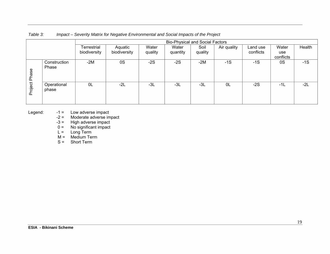
The above mentioned impacts were assessed and classified according to level of severity (from 0 (no significant impact) to -3 (High adverse impact)) and according to length of impact (Short term to long term impacts). Table 3 (overleaf) provides an overview of the level of severity and the time frame for the identified impact for two phases of the project (construction and operation phases).
5.6 Suggested mitigation measures to overcome Potential Negative Environmental and Social Impacts
A number of mitigation measures have been suggested to mitigate and overcome the potential negative impacts associated with rehabilitation of the scheme. These mitigation measures have been listed in detail in Table 6 within the proposed ESMP. The proposed measures form part of the construction and operational stages.
19 ESIA - Bikinani Scheme
Table 3: Impact – Severity Matrix for Negative Environmental and Social Impacts of the Project
Bio-Physical and Social Factors Terrestrial biodiversity
Aquatic biodiversity
Water quality
Water quantity
Soil quality
Air quality Land use conflicts
Water use
conflicts
Health
Pro
ject
Pha
se
Construction Phase
-2M 0S -2S -2S -2M -1S -1S 0S -1S
Operational phase
0L -2L -3L -3L -3L 0L -2S -1L -2L
Legend: -1 = Low adverse impact -2 = Moderate adverse impact -3 = High adverse impact 0 = No significant impact L = Long Term M = Medium Term S = Short Term
20 ESIA - Bikinani Scheme
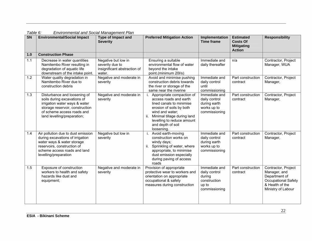
6 ENVIRONMENTAL AND SOCIAL MANAGEMENT AND MONITORING PLANS
6.1 ESMP
Table 6 (page 22) provides a comprehensive overview of the suggested Environmental and Social Management Plan. The plan has taken into consideration only significant negative environmental and social impacts that require attention by concerned stakeholders, based on the existing and projected bio-physical and social conditions in the project area, in order to avoid a decline in environmental quality and to ensure that benefits are sustained. The plans include the time frame in which the implementation is to be completed.
6.2 Contractor Obligations under the ESMP
During the Construction Phase the contractor will be required to adhere to all mitigation measures set out in the ESMP. It is recommended that a number of obligations are included in the contract to ensure compliance. These should include:-
Correct safety procedures on site with adequate training of workers on safety awareness and procedures
Adequate safety wear for site employees Provision of machinery that is in good well maintained condition (unlikely to cause damage
to human beings or the environment). Adherence to waste management guidelines Adherence to guidelines set out for borrow pits Management and control of Dust emissions
6.3. Beneficiary Obligations under the ESMP
After completion of the construction works, Beneficiary Farmers will take the lead role in implementing the measures listed in the EMP during the operational phase. These should be managed through the WUA structure with obligations as follows:-
Participation in Organisational Structure and provision of support to all elected committees Participation in Capacity Building initiatives aimed at improving skills and knowledge Adherence to recommended mitigation measures listed in the EMP to reduce impact on the
elements of the environment (e.g rehabilitation of riverine ecology by not cultivating along the river banks, soil erosion control measures, sustainable agricultural practices- use of manure, crop residues and intercropping; correct irrigation scheduling and maintenance of irrigation and drainage network)
Adhere to conflict resolution on issues of land tenure and low flow conditions.
6.4 Estimated Budget for the ESMP
The estimated cost of implementation of the ESMP has been developed and a summary of which has been presented in Table 4 overleaf. The costs have been generated from either the detailed BoQ from the Detailed design report.
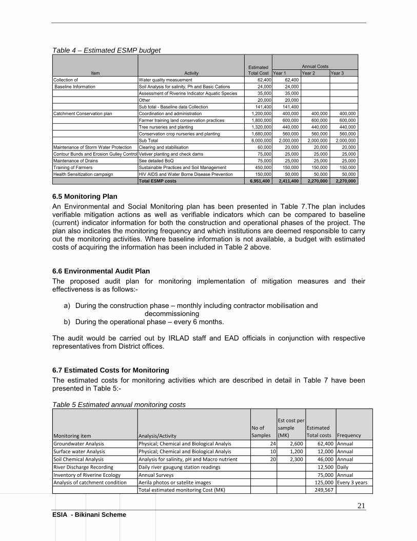
21 ESIA - Bikinani Scheme
Table 4 – Estimated ESMP budget
Year 1 Year 2 Year 3
Collection of Water quality measuement 62,400 62,400
Baseline Information Soil Analysis for salinity, Ph and Basic Cations 24,000 24,000
Assessment of Riverine Indicator Aquatic Species 35,000 35,000
Other 20,000 20,000
Sub total - Baseline data Collection 141,400 141,400
Catchment Conservation plan Coordination and administration 1,200,000 400,000 400,000 400,000
Farmer training land conservation practices 1,800,000 600,000 600,000 600,000
Tree nurseries and planting 1,320,000 440,000 440,000 440,000
Conservation crop nurseries and planting 1,680,000 560,000 560,000 560,000
Sub Total 6,000,000 2,000,000 2,000,000 2,000,000
Maintenance of Storm Water Protection Clearing and stabilisation 60,000 20,000 20,000 20,000
Contour Bunds and Erosion Gulley Control Vetiver planting and check dams 75,000 25,000 25,000 25,000
Maintenance of Drains See detailed BoQ 75,000 25,000 25,000 25,000
Training of Farmers Sustainable Practices and Soil Management 450,000 150,000 150,000 150,000
Health Sensitization campaign HIV AIDS and Water Borne Disease Prevention 150,000 50,000 50,000 50,000
Total ESMP costs 6,951,400 2,411,400 2,270,000 2,270,000
Item ActivityEstimated Total Cost
Annual Costs
6.5 Monitoring Plan
An Environmental and Social Monitoring plan has been presented in Table 7.The plan includes verifiable mitigation actions as well as verifiable indicators which can be compared to baseline (current) indicator information for both the construction and operational phases of the project. The plan also indicates the monitoring frequency and which institutions are deemed responsible to carry out the monitoring activities. Where baseline information is not available, a budget with estimated costs of acquiring the information has been included in Table 2 above.
6.6 Environmental Audit Plan
The proposed audit plan for monitoring implementation of mitigation measures and their effectiveness is as follows:-
a) During the construction phase – monthly including contractor mobilisation and decommissioning
b) During the operational phase – every 6 months.
The audit would be carried out by IRLAD staff and EAD officials in conjunction with respective representatives from District offices.
6.7 Estimated Costs for Monitoring
The estimated costs for monitoring activities which are described in detail in Table 7 have been presented in Table 5:-� Table 5 Estimated annual monitoring costs
Monitoring item Analysis/Activity
No of
Samples
Est cost per
sample
(MK)
Estimated
Total costs Frequency
Groundwater Analysis Physical; Chemical and Biological Analyis 24 2,600 62,400 Annual
Surface water Analysis Physical; Chemical and Biological Analyis 10 1,200 12,000 Annual
Soil Chemical Analysis Analysis for salinity, pH and Macro nutrient 20 2,300 46,000 Annual
River Discharge Recording Daily river gaugung station readings 12,500 Daily
Inventory of Riverine Ecology Annual Surveys 75,000 Annual
Analysis of catchment condition Aerila photos or satelite images 125,000 Every 3 years
Total estimated monitoring Cost (MK) 249,567
22 ESIA - Bikinani Scheme
Table 6: Environmental and Social Management Plan SN Environmental/Social Impact Type of Impact and
Severity Preferred Mitigation Action Implementation
Time frame Estimated Costs Of Mitigating Action
Responsibility
1.0 Construction Phase
1.1 Decrease in water quantities Namitembo River resulting in degradation of aquatic life downstream of the intake point.
Negative but low in severity due to insignificant abstraction of water.
Ensuring a suitable environmental flow of water beyond the intake point.(minimum 20l/s)
Immediate and daily thereafter
n/a Contractor, Project Manager, WUA
1.2 Water quality degradation in Namitembo River due to construction debris
Negative and moderate in severity
Avoid and minimise pushing construction debris towards the river or storage of the same near the riverine
Immediate and daily control until commissioning
Part construction contract
Contractor, Project Manager,
1.3 Disturbance and loosening of soils during excavations of irrigation water ways & water storage reservoir, construction of scheme access roads and land levelling/preparation;
Negative and moderate in severity
i. Appropriate compaction of access roads and earth lined canals to minimise erosion of soils by both wind and water;
ii. Minimal tillage during land levelling to reduce amount and depth of soil loosening.
Immediate and daily control during earth works up to commissioning
Part construction contract
Contractor, Project Manager,
1.4 Air pollution due to dust emission during excavations of irrigation water ways & water storage reservoirs, construction of scheme access roads and land levelling/preparation
Negative but low in severity
i. Avoid earth-moving construction works on windy days;
ii. Sprinkling of water, where appropriate, to minimise dust emission especially during paving of access roads
Immediate and daily control during earth works up to commissioning
Part construction contract
Contractor, Project Manager,
1.5 Exposure of construction workers to health and safety hazards like dust and equipment;
Negative and moderate in severity
Provision of appropriate protective wear to workers and orientation on appropriate occupational & safety measures during construction
Immediate and daily control during construction up to commissioning
Part construction contract
Contractor, Project Manager, and Department of Occupational Safety & Health of the Ministry of Labour
23 ESIA - Bikinani Scheme
SN Environmental/Social Impact Type of Impact and Severity
Preferred Mitigation Action Implementation Time frame
Estimated Costs Of Mitigating Action
Responsibility
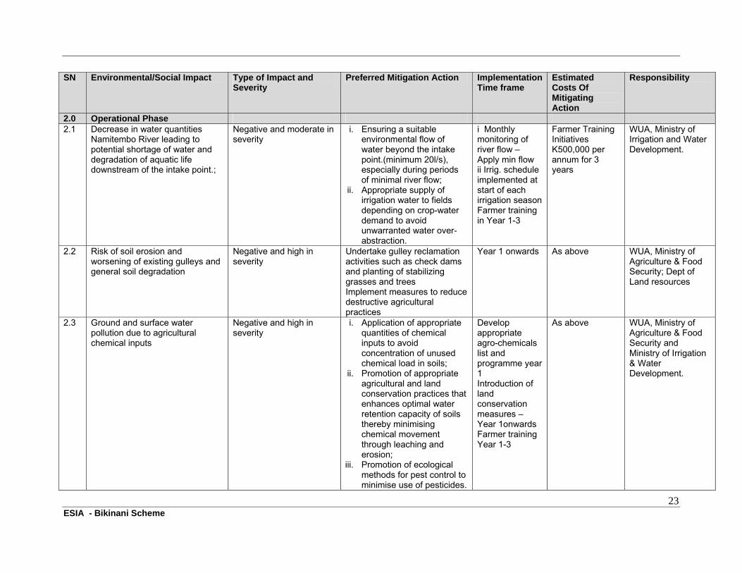
2.0 Operational Phase 2.1 Decrease in water quantities
Namitembo River leading to potential shortage of water and degradation of aquatic life downstream of the intake point.;
Negative and moderate in severity
i. Ensuring a suitable environmental flow of water beyond the intake point.(minimum 20l/s), especially during periods of minimal river flow;
ii. Appropriate supply of irrigation water to fields depending on crop-water demand to avoid unwarranted water over- abstraction.
i Monthly monitoring of river flow – Apply min flow ii Irrig. schedule implemented at start of each irrigation season Farmer training in Year 1-3
Farmer Training Initiatives K500,000 per annum for 3 years
WUA, Ministry of Irrigation and Water Development.
2.2 Risk of soil erosion and worsening of existing gulleys and general soil degradation
Negative and high in severity
Undertake gulley reclamation activities such as check dams and planting of stabilizing grasses and trees Implement measures to reduce destructive agricultural practices
Year 1 onwards As above WUA, Ministry of Agriculture & Food Security; Dept of Land resources
2.3 Ground and surface water pollution due to agricultural chemical inputs
Negative and high in severity
i. Application of appropriate quantities of chemical inputs to avoid concentration of unused chemical load in soils;
ii. Promotion of appropriate agricultural and land conservation practices that enhances optimal water retention capacity of soils thereby minimising chemical movement through leaching and erosion;
iii. Promotion of ecological methods for pest control to minimise use of pesticides.
Develop appropriate agro-chemicals list and programme year 1 Introduction of land conservation measures – Year 1onwards Farmer training Year 1-3
As above WUA, Ministry of Agriculture & Food Security and Ministry of Irrigation & Water Development.
24 ESIA - Bikinani Scheme
SN Environmental/Social Impact Type of Impact and Severity
Preferred Mitigation Action Implementation Time frame
Estimated Costs Of Mitigating Action
Responsibility
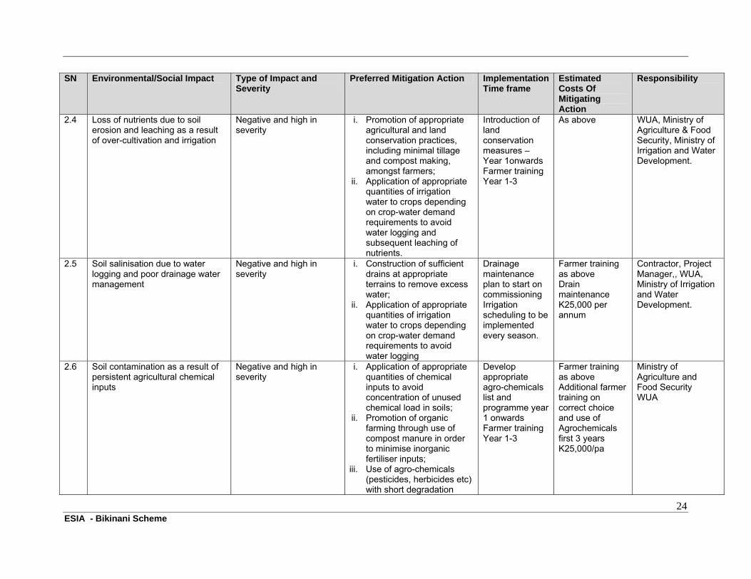
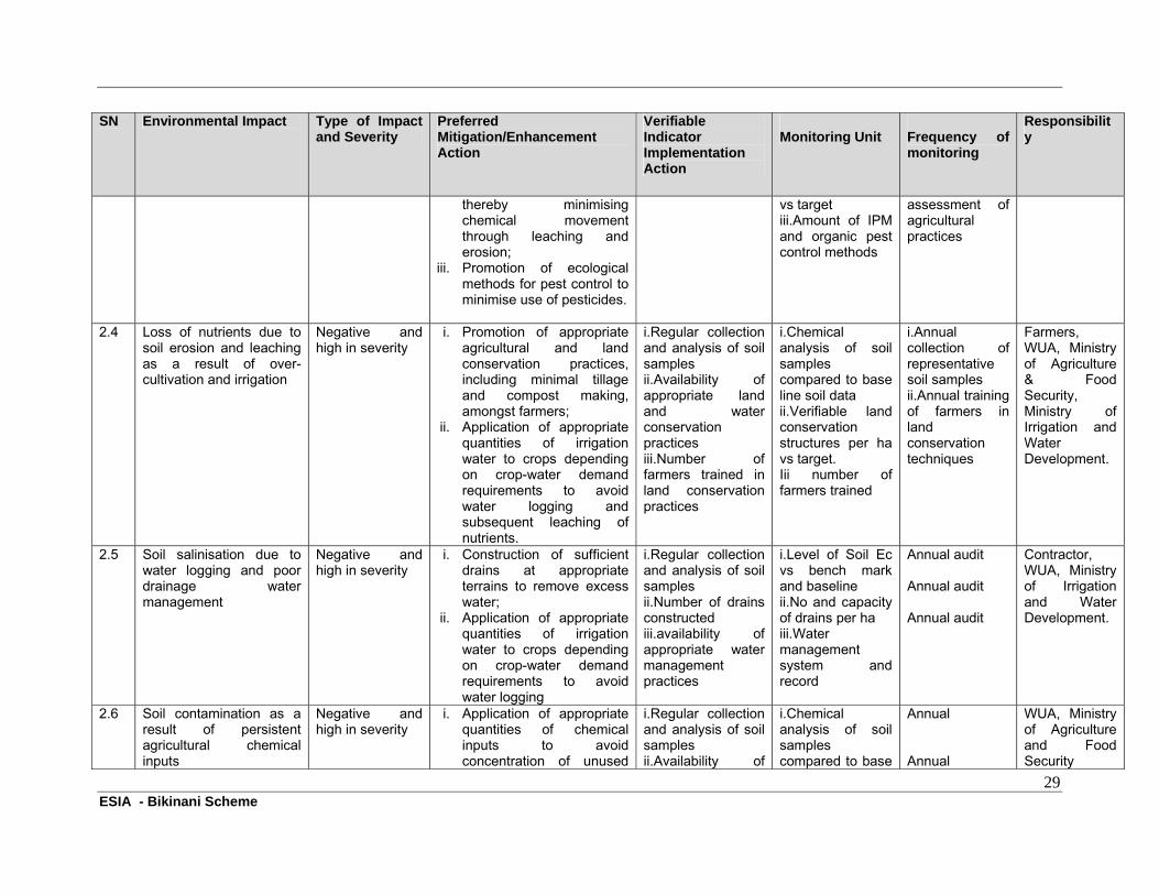
2.4 Loss of nutrients due to soil erosion and leaching as a result of over-cultivation and irrigation
Negative and high in severity
i. Promotion of appropriate agricultural and land conservation practices, including minimal tillage and compost making, amongst farmers;
ii. Application of appropriate quantities of irrigation water to crops depending on crop-water demand requirements to avoid water logging and subsequent leaching of nutrients.
Introduction of land conservation measures – Year 1onwards Farmer training Year 1-3
As above WUA, Ministry of Agriculture & Food Security, Ministry of Irrigation and Water Development.
2.5 Soil salinisation due to water logging and poor drainage water management
Negative and high in severity
i. Construction of sufficient drains at appropriate terrains to remove excess water;
ii. Application of appropriate quantities of irrigation water to crops depending on crop-water demand requirements to avoid water logging
Drainage maintenance plan to start on commissioning Irrigation scheduling to be implemented every season.
Farmer training as above Drain maintenance K25,000 per annum
Contractor, Project Manager,, WUA, Ministry of Irrigation and Water Development.
2.6 Soil contamination as a result of persistent agricultural chemical inputs
Negative and high in severity
i. Application of appropriate quantities of chemical inputs to avoid concentration of unused chemical load in soils;
ii. Promotion of organic farming through use of compost manure in order to minimise inorganic fertiliser inputs;
iii. Use of agro-chemicals (pesticides, herbicides etc) with short degradation
Develop appropriate agro-chemicals list and programme year 1 onwards Farmer training Year 1-3
Farmer training as above Additional farmer training on correct choice and use of Agrochemicals first 3 years K25,000/pa
Ministry of Agriculture and Food Security WUA
25 ESIA - Bikinani Scheme
SN Environmental/Social Impact Type of Impact and Severity
Preferred Mitigation Action Implementation Time frame
Estimated Costs Of Mitigating Action
Responsibility
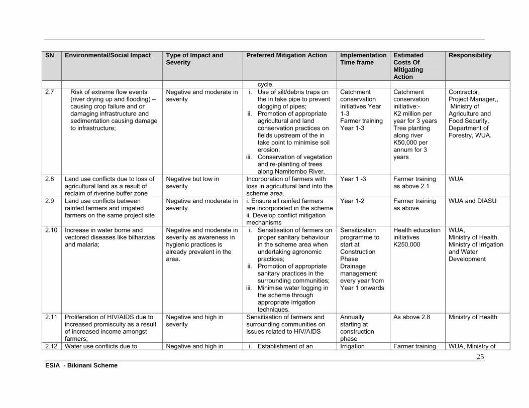
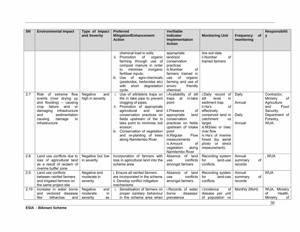
cycle. 2.7 Risk of extreme flow events
(river drying up and flooding) – causing crop failure and or damaging infrastructure and sedimentation causing damage to infrastructure;
Negative and moderate in severity
i. Use of silt/debris traps on the in take pipe to prevent clogging of pipes;
ii. Promotion of appropriate agricultural and land conservation practices on fields upstream of the in take point to minimise soil erosion;
iii. Conservation of vegetation and re-planting of trees along Namitembo River.
Catchment conservation initiatives Year 1-3 Farmer training Year 1-3
Catchment conservation initiative:- K2 million per year for 3 years Tree planting along river K50,000 per annum for 3 years
Contractor, Project Manager,, Ministry of Agriculture and Food Security, Department of Forestry, WUA.
2.8 Land use conflicts due to loss of agricultural land as a result of reclaim of riverine buffer zone
Negative but low in severity
Incorporation of farmers with loss in agricultural land into the scheme area.
Year 1 -3 Farmer training as above 2.1
WUA
2.9 Land use conflicts between rainfed farmers and irrigated farmers on the same project site
Negative and moderate in severity
i. Ensure all rainfed farmers are incorporated in the scheme ii. Develop conflict mitigation mechanisms
Year 1-2 Farmer training as above
WUA and DIASU
2.10 Increase in water borne and vectored diseases like bilharzias and malaria;
Negative and moderate in severity as awareness in hygienic practices is already prevalent in the area.
i. Sensitisation of farmers on proper sanitary behaviour in the scheme area when undertaking agronomic practices;
ii. Promotion of appropriate sanitary practices in the surrounding communities;
iii. Minimise water logging in the scheme through appropriate irrigation techniques.
Sensitization programme to start at Construction Phase Drainage management every year from Year 1 onwards
Health education initiatives K250,000
WUA, Ministry of Health, Ministry of Irrigation and Water Development
2.11 Proliferation of HIV/AIDS due to increased promiscuity as a result of increased income amongst farmers;
Negative and high in severity
Sensitisation of farmers and surrounding communities on issues related to HIV/AIDS
Annually starting at construction phase
As above 2.8 Ministry of Health
2.12 Water use conflicts due to Negative and high in i. Establishment of an Irrigation Farmer training WUA, Ministry of
26 ESIA - Bikinani Scheme
SN Environmental/Social Impact Type of Impact and Severity
Preferred Mitigation Action Implementation Time frame
Estimated Costs Of Mitigating Action
Responsibility
increased demand for irrigation water against decreased water supply quantities
severity appropriate system on sharing of water by farmers;
ii. Application of appropriate quantities of irrigation water to crops depending on crop-water demand requirements to avoid water wastage.
scheduling to be implemented every season Cap building annually for first 3 years.
as above 2.1 Irrigation and Water Development.
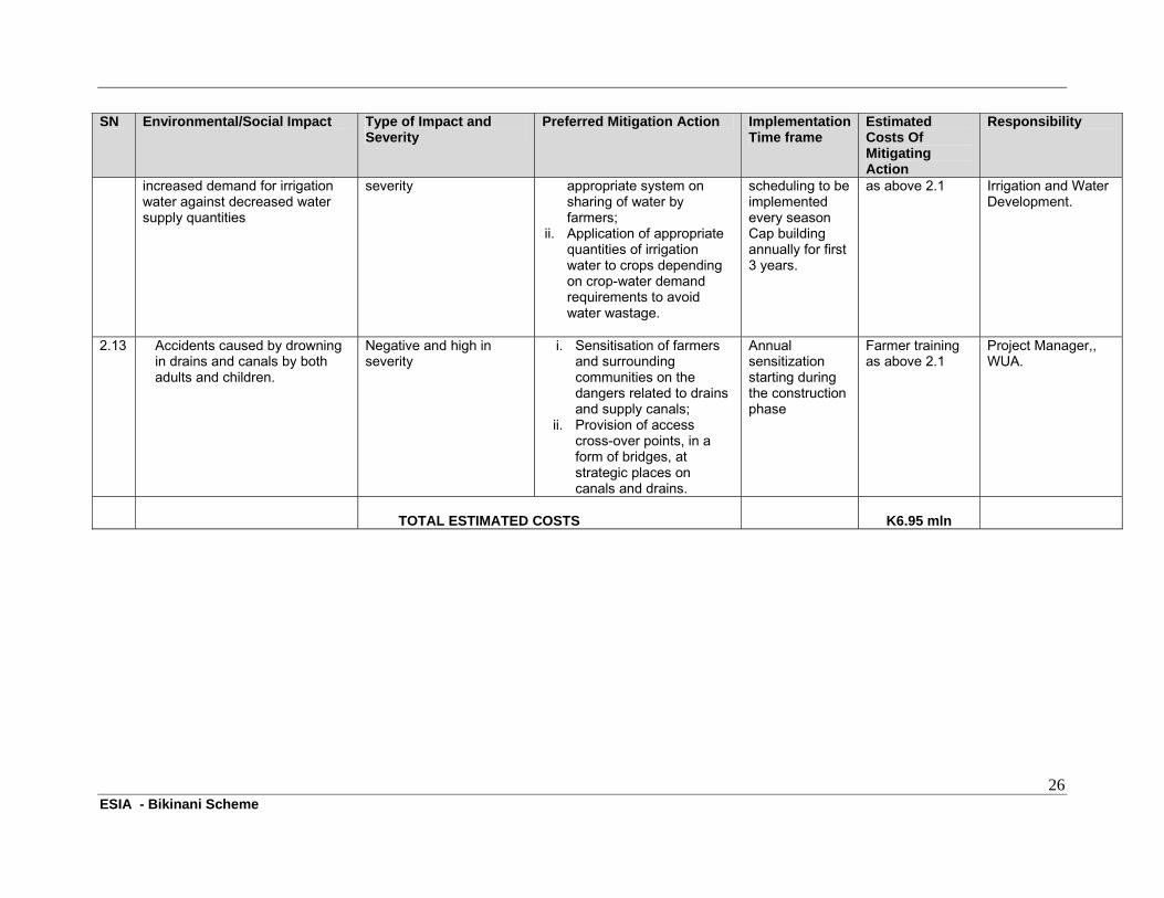
2.13 Accidents caused by drowning in drains and canals by both adults and children.
Negative and high in severity
i. Sensitisation of farmers and surrounding communities on the dangers related to drains and supply canals;
ii. Provision of access cross-over points, in a form of bridges, at strategic places on canals and drains.
Annual sensitization starting during the construction phase
Farmer training as above 2.1
Project Manager,, WUA.
TOTAL ESTIMATED COSTS K6.95 mln
27 ESIA - Bikinani Scheme
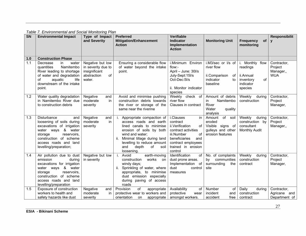
Table 7. Environmental and Social Monitoring Plan SN Environmental Impact Type of Impact
and Severity Preferred Mitigation/Enhancement Action
Verifiable Indicator Implementation Action
Monitoring Unit Frequency of monitoring
Responsibility
1.0 Construction Phase 1.1 Decrease in water
quantities Namitembo River leading to shortage of water and degradation of aquatic life downstream of the intake point.
Negative but low in severity due to insignificant abstraction of water.
Ensuring a considerable flow of water beyond the intake point.
i.Minimum Environ flow:- April – June: 30l/s July-Sept:15l/s Oct-Dec:5l/s ii. Monitor indicator species
i.M3/sec or l/s of river flow ii.Comparison of indicator to baseline
i. Monthly flow readings ii.Annual inventory of indicator species
Contractor, Project Manager,, WUA
1.2 Water quality degradation in Namitembo River due to construction debris
Negative and moderate in severity
Avoid and minimise pushing construction debris towards the river or storage of the same near the riverine
Weekly check of river flow Clauses in contract
Amount of debris in Namitembo River Water quality analysis
Weekly during construction
Contractor, Project Manager,
1.3 Disturbance and loosening of soils during excavations of irrigation water ways & water storage reservoirs, construction of scheme access roads and land levelling/preparation;
Negative and moderate in severity
i. Appropriate compaction of access roads and earth lined canals to minimise erosion of soils by both wind and water;
ii. Minimal tillage during land levelling to reduce amount and depth of soil loosening.
i.Clauses in contract ii.Verification of contract activities iii.Number of beneficiaries and contract employees trained in erosion control
Amount of soil eroded Visible signs of gulleys and other erosion features
Weekly during construction by consultant Monthly Audit
Contractor, Project Manager,,
1.4 Air pollution due to dust emission during excavations for irrigation water ways & water storage reservoirs, construction of scheme access roads and land levelling/preparation
Negative but low in severity
i. Avoid earth-moving construction works on windy days;
ii. Sprinkling of water, where appropriate, to minimise dust emission especially during paving of access roads
Identification of dust prone areas. Implementation of dust control measures
No. of complaints by communities surrounding the site
Weekly during construction contract
Contractor, Project Manager,
1.5 Exposure of construction workers to health and safety hazards like dust
Negative and moderate in severity
Provision of appropriate protective wear to workers and orientation on appropriate
Availability of protective wear amongst workers.
Number of incident and accident free
Daily during construction contract
Contractor, Agricane and Department of
28 ESIA - Bikinani Scheme
SN Environmental Impact Type of Impact and Severity
Preferred Mitigation/Enhancement Action
Verifiable Indicator Implementation Action
Monitoring Unit Frequency of monitoring
Responsibility
and equipment;
occupational & safety measures during the construction
Number of employees trained in occupational safety incidents Clause in contract
days. Record of accidents
Occupational Safety & Health of the Ministry of Labour
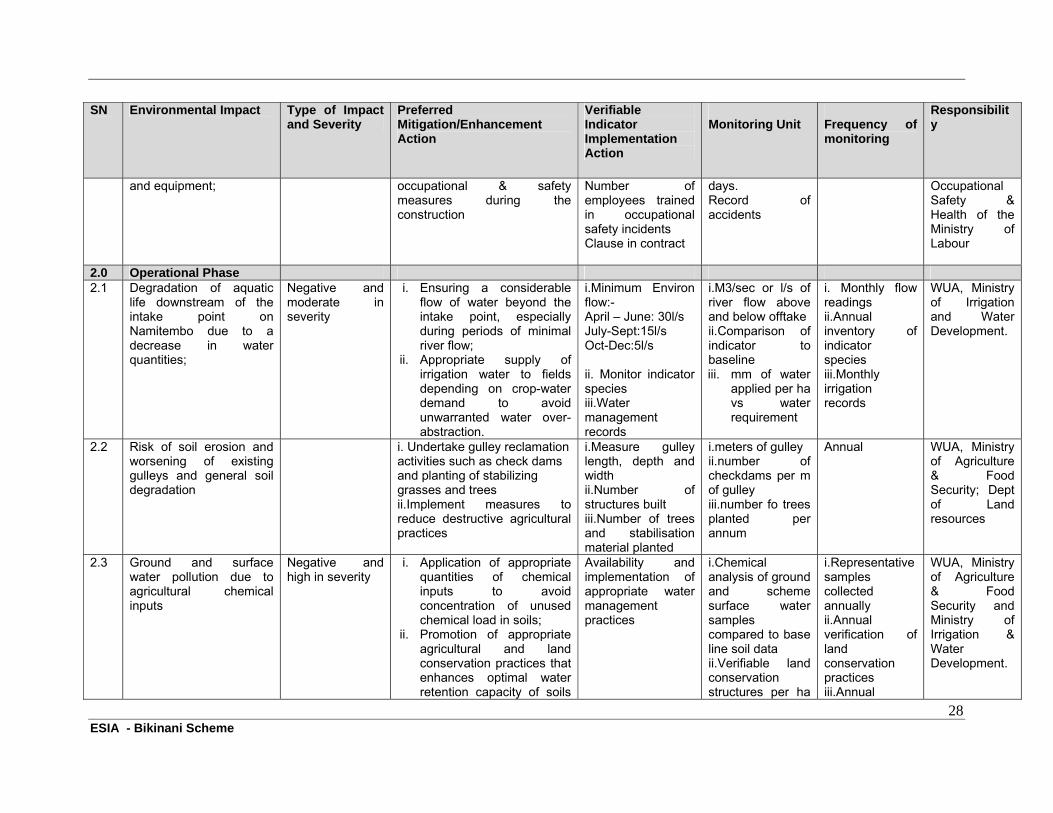
2.0 Operational Phase 2.1 Degradation of aquatic
life downstream of the intake point on Namitembo due to a decrease in water quantities;
Negative and moderate in severity
i. Ensuring a considerable flow of water beyond the intake point, especially during periods of minimal river flow;
ii. Appropriate supply of irrigation water to fields depending on crop-water demand to avoid unwarranted water over- abstraction.
i.Minimum Environ flow:- April – June: 30l/s July-Sept:15l/s Oct-Dec:5l/s ii. Monitor indicator species iii.Water management records
i.M3/sec or l/s of river flow above and below offtake ii.Comparison of indicator to baseline iii. mm of water
applied per ha vs water requirement
i. Monthly flow readings ii.Annual inventory of indicator species iii.Monthly irrigation records
WUA, Ministry of Irrigation and Water Development.
2.2 Risk of soil erosion and worsening of existing gulleys and general soil degradation
i. Undertake gulley reclamation activities such as check dams and planting of stabilizing grasses and trees ii.Implement measures to reduce destructive agricultural practices
i.Measure gulley length, depth and width ii.Number of structures built iii.Number of trees and stabilisation material planted
i.meters of gulley ii.number of checkdams per m of gulley iii.number fo trees planted per annum
Annual WUA, Ministry of Agriculture & Food Security; Dept of Land resources
2.3 Ground and surface water pollution due to agricultural chemical inputs
Negative and high in severity
i. Application of appropriate quantities of chemical inputs to avoid concentration of unused chemical load in soils;
ii. Promotion of appropriate agricultural and land conservation practices that enhances optimal water retention capacity of soils
Availability and implementation of appropriate water management practices
i.Chemical analysis of ground and scheme surface water samples compared to base line soil data ii.Verifiable land conservation structures per ha
i.Representative samples collected annually ii.Annual verification of land conservation practices iii.Annual
WUA, Ministry of Agriculture & Food Security and Ministry of Irrigation & Water Development.
29 ESIA - Bikinani Scheme
SN Environmental Impact Type of Impact and Severity
Preferred Mitigation/Enhancement Action
Verifiable Indicator Implementation Action
Monitoring Unit Frequency of monitoring
Responsibility
thereby minimising chemical movement through leaching and erosion;
iii. Promotion of ecological methods for pest control to minimise use of pesticides.
vs target iii.Amount of IPM and organic pest control methods
assessment of agricultural practices
2.4 Loss of nutrients due to soil erosion and leaching as a result of over-cultivation and irrigation
Negative and high in severity
i. Promotion of appropriate agricultural and land conservation practices, including minimal tillage and compost making, amongst farmers;
ii. Application of appropriate quantities of irrigation water to crops depending on crop-water demand requirements to avoid water logging and subsequent leaching of nutrients.
i.Regular collection and analysis of soil samples ii.Availability of appropriate land and water conservation practices iii.Number of farmers trained in land conservation practices
i.Chemical analysis of soil samples compared to base line soil data ii.Verifiable land conservation structures per ha vs target. Iii number of farmers trained
i.Annual collection of representative soil samples ii.Annual training of farmers in land conservation techniques
Farmers, WUA, Ministry of Agriculture & Food Security, Ministry of Irrigation and Water Development.
2.5 Soil salinisation due to water logging and poor drainage water management
Negative and high in severity
i. Construction of sufficient drains at appropriate terrains to remove excess water;
ii. Application of appropriate quantities of irrigation water to crops depending on crop-water demand requirements to avoid water logging
i.Regular collection and analysis of soil samples ii.Number of drains constructed iii.availability of appropriate water management practices
i.Level of Soil Ec vs bench mark and baseline ii.No and capacity of drains per ha iii.Water management system and record
Annual audit Annual audit Annual audit
Contractor, WUA, Ministry of Irrigation and Water Development.
2.6 Soil contamination as a result of persistent agricultural chemical inputs
Negative and high in severity
i. Application of appropriate quantities of chemical inputs to avoid concentration of unused
i.Regular collection and analysis of soil samples ii.Availability of
i.Chemical analysis of soil samples compared to base
Annual Annual
WUA, Ministry of Agriculture and Food Security
30 ESIA - Bikinani Scheme
SN Environmental Impact Type of Impact and Severity
Preferred Mitigation/Enhancement Action
Verifiable Indicator Implementation Action
Monitoring Unit Frequency of monitoring
Responsibility
chemical load in soils; ii. Promotion of organic
farming through use of compost manure in order to minimise inorganic fertiliser inputs;
iii. Use of agro-chemicals (pesticides, herbicides etc) with short degradation cycle.
appropriate land/soil conservation practices iii.Number of farmers trained in use of organic farming and use of enviro friendly chemical
line soil data ii.Number of trained farmers
2.7 Risk of extreme flow events (river drying up and flooding) – causing crop failure and or damaging infrastructure and sedimentation causing damage to infrastructure
Negative and high in severity
i. Use of silt/debris traps on the in take pipe to prevent clogging of pipes;
ii. Promotion of appropriate agricultural and land conservation practices on fields upstream of the in take point to minimise soil erosion;
iii. Conservation of vegetation and re-planting of trees along Namitembo River.
i.Availability of silt traps at in-take point ii.Presence of appropriate land conservation practices on fields upstream of intake point iii.Regular Flow measurements iv.Amount of vegetation along Namitembo River
i.Daily record of silt level in sediment trap. ii.Ha’s of effectively conserved land in catchment vs target. iii.M3/sec or l/sec river flow iv.Ha’s of riverine forest (by aerial photo or direct measurement).
Daily Annual Daily Annual
Contractor, Ministry of Agriculture and Food Security, Department of Forestry, WUA.
2.8 Land use conflicts due to loss of agricultural land as a result of reclaim of riverine buffer zone
Negative but low in severity
Incorporation of farmers with loss in agricultural land into the scheme area.
Absence of land use conflicts amongst farmers
Recording system for land-use conflicts
Annual summary of records
, WUA
2.9 Land use conflicts between rainfed farmers and irrigated farmers on the same project site
Negative and moderate in severity
i. Ensure all rainfed farmers are incorporated in the scheme ii. Develop conflict mitigation mechanisms
Absence of land use conflicts amongst farmers
Recording system for land-use conflicts
Annual summary of records
WUA
2.10 Increase in water borne and vectored diseases like bilharzias and
Negative and moderate in severity as
i. Sensitisation of farmers on proper sanitary behaviour in the scheme area when
i.Records of water borne diseases’ prevalence
i.Incidence of disease per unit of population vs
Monthly (MoH)
WUA, Ministry of Health, Ministry of
31 ESIA - Bikinani Scheme
SN Environmental Impact Type of Impact and Severity
Preferred Mitigation/Enhancement Action
Verifiable Indicator Implementation Action
Monitoring Unit Frequency of monitoring
Responsibility
malaria; awareness in hygienic practices is already prevalent in the area.
undertaking agronomic practices;
ii. Promotion of appropriate sanitary practices in the surrounding communities;
iii. Minimise water logging in the scheme through appropriate irrigation techniques.
ii.Regular collection and analysis of water samples iii.Availability of appropriate sanitary hardware
baseline data (2008) ii.Water analysis vs baseline iii.No of toilets
Monthly (Central Water Laboratory) Annual
Irrigation and Water Development
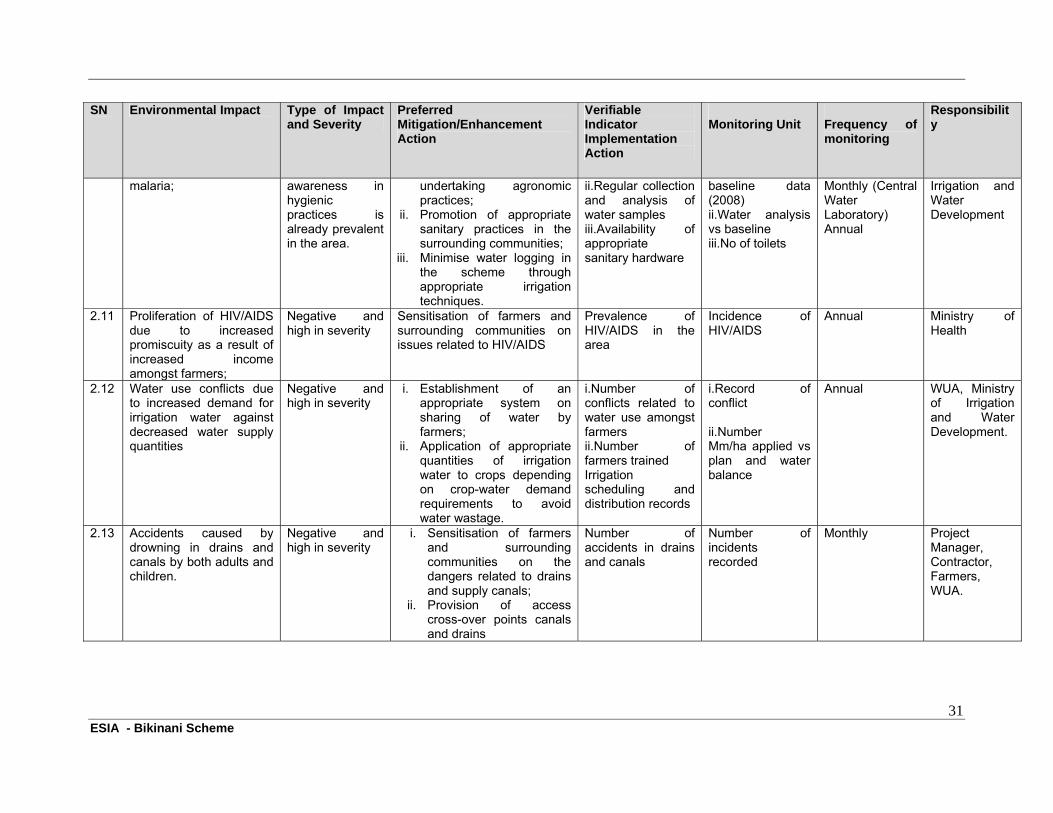
2.11 Proliferation of HIV/AIDS due to increased promiscuity as a result of increased income amongst farmers;
Negative and high in severity
Sensitisation of farmers and surrounding communities on issues related to HIV/AIDS
Prevalence of HIV/AIDS in the area
Incidence of HIV/AIDS
Annual Ministry of Health
2.12 Water use conflicts due to increased demand for irrigation water against decreased water supply quantities
Negative and high in severity
i. Establishment of an appropriate system on sharing of water by farmers;
ii. Application of appropriate quantities of irrigation water to crops depending on crop-water demand requirements to avoid water wastage.
i.Number of conflicts related to water use amongst farmers ii.Number of farmers trained Irrigation scheduling and distribution records
i.Record of conflict ii.Number Mm/ha applied vs plan and water balance
Annual WUA, Ministry of Irrigation and Water Development.
2.13 Accidents caused by drowning in drains and canals by both adults and children.
Negative and high in severity
i. Sensitisation of farmers and surrounding communities on the dangers related to drains and supply canals;
ii. Provision of access cross-over points canals and drains
Number of accidents in drains and canals
Number of incidents recorded
Monthly Project Manager, Contractor, Farmers, WUA.
32 ESIA - Bikinani Scheme
7 CONCLUSIONS AND RECOMMENDATIONS
The Bikinani Irrigation Scheme has a high potential to change the socio-economic profile of the communities in Chingale EPA for the better. However, there is need to ensure that the proposed mitigation measures outlined in this management and monitoring plan are given prior consideration at appropriate stages of the project as suggested. All the beneficiaries and responsible implementing and monitoring stakeholders will have a role in the effective sustainability of this project. Below are the recommendations for this Environmental and Social Management and Monitoring Plan, which have dwelled much on the sustainability of the scheme as a function of the stability of the ecosystem in and around the project area. Thus; a) The scheme beneficiaries and the institutions charged with the monitoring responsibilities will be required to ensure that the catchment area of Namitembo River is protected at all times. This is because the scheme is dependent on the availability of water which likely decrease if the river catchment area is disturbed. Agricultural activities upstream of Namitembo River, especially around the Njerenje stream - an additional source of water for the scheme - are a threat to the sustainability of Bikinani Scheme in as far as water use competition is concerned. Collaborative efforts will be required between the farmers in the scheme and upstream farmers to ensure that the riverine of both rivers are restored and protected; b) Proper land conservation and agricultural practices shall have to be enforced by agricultural extension advisors and relevant institutions at all times as lack of these will cause substantial loss of soils and nutrients, the result of which will be significant reduction in agricultural outputs by the target beneficiaries. Lack of these practices upstream of the scheme will have adverse effects on the stability of the scheme’s weir structures as sediments and boulders will likely weaken the structures or choke the conveyance pipes; c) The topography of much of the land on this scheme, especially on the south-western bank of Namitembo River is gentle and thus a favourable terrain for water logging. Proper water management practices will therefore be required at all times to avoid soil salinisation. This is because soil salinisation has been known to shorten lifespans of irrigation schemes dramatically worldwide and in the process causing significant irreversible adverse socio-economic effects on beneficiaries.
33 ESIA - Bikinani Scheme
REFERENCES
1. Agricane Malawi Ltd in Association with SSI Environmental and Consulting Engineers, October 2008, “Preliminary Design Report for Bikinani Scheme”, Nchalo, Malawi;
2. Brils, C., Van de Ende, P., De Leede, B., Paap, P., & Wallace, L.; 1996, “Agroforestry”,
Agrodok Series Number 16. Agromisa, Wageningen, Netherlands; 3. Center for Agriculture in the Environment, 2005, “The environmental benefits of a well-
managed farmland”, Center for agriculture in the environment working paper number 2005-01. American Farmland Trust, Dekalb, Illinois, USA;
4. Government of Malawi, 1997, “Guidelines for Environmental Impact Assessment”,
Environmental Affairs Department, Lilongwe, Malawi; 5. Government of Malawi, 1996, “Occupational Health, Safety and Welfare Act”, Ministry of
Labour, Lilongwe, Malawi; 6. Glover, C.R.; 2001, “Irrigation water classification systems”, New Mexico State University
(NMSU), Mexico.
34 ESIA - Bikinani Scheme
ANNEXE 1: List of Stakeholders Consulted During the Assessment
1. Ms Clara Chidammodzi Water Management Specialist (Water Users
Association Coordinator); Ministry of Irrigation and Water Development, Zomba District Irrigation Advisory Service Unit (DIASU);
2. Ms Gertrude Chibisa Water Management Specialist; Ministry of Irrigation and
Water Development, Zomba District Irrigation Advisory Service Unit (DIASU);
3. Mr G Mandala Chairman, Bikinani Irrigation Management Committee; 4. Mr L James Vice Chairperson, Bikinani Irrigation Management
Committee; 5. Mr K Kalombola Secretary, Bikinani Irrigation Management Committee; 6. Mr J Mkwanda Member, Bikinani Irrigation Management Committee; 7. Mr Magombo Agricultural Extension Development Officer, Chingale
EPA, Zomba; 8. Mrs Esnati Kalombola Farmer, Bikinani Irrigation Scheme; 9. Mrs Enifa Mandala Farmer, Bikinani Irrigation Scheme; 10. Mrs Loveness Namalira Farmer, Bikinani Irrigation Scheme; 11. Mrs Mphatso Wilachi Farmer, Bikinani Irrigation Scheme; 12. Mrs Modesta John Farmer, Bikinani Irrigation Scheme 13. Mrs Emily Chipwere Farmer, Bikinani Irrigation Scheme; 14. Miss Grace Lameck Farmer, Bikinani Irrigation Scheme; 15. Miss Ellen Davie Farmer, Bikinani Irrigation Scheme; 16. Mr James Kuluponde Farmer, Bikinani Irrigation Scheme; 17. Miss Flora Jacks Farmer, Bikinani Irrigation Scheme; 18. Miss Ethel Tanaposi Farmer, Bikinani Irrigation Scheme; 19. Mr Davie Gerald Farmer, Bikinani Irrigation Scheme; 20. Mr Patrick Tchale Farmer, Bikinani Irrigation Scheme; 21. Mrs Daina James Farmer, Bikinani Irrigation Scheme; 22. Miss Rose Kalonga Farmer, Bikinani Irrigation Scheme; 23. Miss Gladys John Farmer, Bikinani Irrigation Scheme;

35 ESIA - Bikinani Scheme
24. Mr Baisoni Matimba Farmer, Bikinani Irrigation Scheme; 25. Miss Patuma Wilson Farmer, Bikinani Irrigation Scheme; 26. Miss Grace Kamwendo Farmer, Bikinani Irrigation Scheme; 27. Miss Christina Stephano Farmer, Bikinani Irrigation Scheme; 28. Miss Felista James Farmer, Bikinani Irrigation Scheme; 29. Mrs Stevelia Stephano Farmer, Bikinani Irrigation Scheme; 30. Miss Awetu Asani Farmer, Bikinani Irrigation Scheme.


![[ESIA PINTUQUÍMICA CÍA. LTDA.]](https://img.pdfslide.tips/doc/110x75/6262c1268706d84434490da6/esia-pintuqumica-ca-ltda.jpg)
