Embed Size (px)
Citation preview

I C E M | B I R D L I F E | C Y S N P P A R K M A N A G E M E N T B O A R D
C Y S N P R O A D A S S E S S M E N T | R O A D & T R A I L A S S E S S M E N T R E P O R T | 2 0 1 0 | 1
Birdlife International & Chu Yang Sin Park Management Board
CHU YANG S IN NAT IONAL PARK ASSESSMENT OF PROPOSED ROAD & TRAIL
DEVELOPMENTS IN THE CORE ZONE
VOL 1 FINAL REPORT
29 MARCH 2010
I C E M | B I R D L I F E | C Y S N P P A R K M A N A G E M E N T B O A R D
C Y S N P R O A D A S S E S S M E N T | R O A D & T R A I L A S S E S S M E N T R E P O R T | 2 0 1 0 | 2
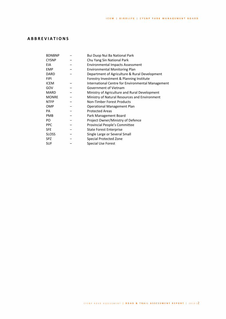
A B B R E V I A T I O N S
BDNBNP – Bui Duop Nui Ba National ParkCYSNP – Chu Yang Sin National ParkEIA – Environmental Impacts AssessmentEMP – Environmental Monitoring PlanDARD – Department of Agriculture & Rural Development FIPI Forestry Investment & Planning InstituteICEM – International Centre for Environmental Management GOV – Government of VietnamMARD – Ministry of Agriculture and Rural DevelopmentMONRE – Ministry of Natural Resources and Environment NTFP – Non‐Timber Forest ProductsOMP – Operational Management PlanPA – Protected AreasPMB – Park Management BoardPO – Project Owner/Ministry of DefencePPC – Provincial People’s CommitteeSFE – State Forest EnterpriseSLOSS – Single Large or Several SmallSPZ – Special Protected ZoneSUF – Special Use Forest

I C E M | B I R D L I F E | C Y S N P P A R K M A N A G E M E N T B O A R D
C Y S N P R O A D A S S E S S M E N T | R O A D & T R A I L A S S E S S M E N T R E P O R T | 2 0 1 0 | 3
Contents Executive Summary ...................................................................................................................................... 5
PART A: THE CYSNP CONTEXT ...................................................................................................................... 8
1.0 Introduction .................................................................................................................................... 9
1.1 Background ............................................................................................................................................................. 9
1.2 Purpose .................................................................................................................................................................. 9
1.3 Scope .................................................................................................................................................................... 10
2.0 Description of the Environment .................................................................................................... 12
2.1 Background and institutional context.................................................................................................................. 12
2.2 Biodiversity value of CYSNP .................................................................................................................................. 12
2.3 Landscape values .................................................................................................................................................. 16
2.4 Existing vulnerabilities and threats of CYSNP ....................................................................................................... 17
PART B: THE ROAD .................................................................................................................................... 21
3.0 Description of the Road Proposal ................................................................................................... 22
3.1 Background and institutional context .................................................................................................................. 22
3.2 Proposed design characteristics ........................................................................................................................... 23
3.3 Stakeholder analysis ............................................................................................................................................. 23
3.4 Scheduling, milestones & the decision making process ...................................................................................... 24
3.5 The decision making tree & strategic points of engagement ............................................................................... 25
4.0 Alternatives to the Road route ....................................................................................................... 27
4.1 Regulatory context ............................................................................................................................................... 27
4.2 Exploration to date ............................................................................................................................................... 27
4.3. Other alternative routes ....................................................................................................................................... 28
4.3 Recommendations ............................................................................................................................................... 30
5.0 Impacts of the Road ....................................................................................................................... 31
5.1 Threats and potentially impacting activities ......................................................................................................... 31
5.2 Construction impacts ............................................................................................................................................ 33
5.3 Operational impacts ............................................................................................................................................. 35
5.4 Priority impacts .................................................................................................................................................... 37
5.4.1 Zones of impacts and influence ................................................................................................................... 38
5.4.2 Protected Area integrity .............................................................................................................................. 40
5.4.2 Irreversible or irretrievable impacts ............................................................................................................ 41
6.0 Recommendations for road mitigation and EMP ............................................................................ 43
6.1 Mitigation measures for road detailed design ..................................................................................................... 43
6.2 Mitigation measures for construction phase........................................................................................................ 43
6.3 Mitigation measures for operational phase ........................................................................................................ 46
PART C: THE TRAILS ................................................................................................................................... 49
7.0 Description of the Trail network ..................................................................................................... 50
7.1 Existing network & institutional context .............................................................................................................. 50
7.2 Current and future users of the trail network ...................................................................................................... 50
7.3 Illegal use of the trail network .............................................................................................................................. 50
7.4 Current management of trail network ................................................................................................................. 51

I C E M | B I R D L I F E | C Y S N P P A R K M A N A G E M E N T B O A R D
C Y S N P R O A D A S S E S S M E N T | R O A D & T R A I L A S S E S S M E N T R E P O R T | 2 0 1 0 | 4
7.5 Proposed developments for the trail network .................................................................................................... 51
8.0 Alternatives and options for trail development .............................................................................. 53
9.0 Impacts of the trail network ........................................................................................................... 57
9.1 Key impacts & Protect Area integrity ................................................................................................................... 57
9.2 Impacts of trail type ............................................................................................................................................. 57
9.3 Construction impacts ............................................................................................................................................ 58
9.4 Operational Impacts ............................................................................................................................................. 59
9.4.1 Zone of impact and influence ...................................................................................................................... 61
9.5 Mitigation measures and design recommendations for trail development ......................................................... 63
PART D: CONCLUSIONS .............................................................................................................................. 65
10.0 Cumulative impacts of road & trail network .................................................................................. 66
11.0 Conclusions & recommendations .................................................................................................. 67
11.1 Threats .................................................................................................................................................................. 67
11.2 Impacts ................................................................................................................................................................. 67
11.2.1 impacts of the proposed road development ............................................................................................. 67
11.2.2 Impacts of the proposed trail developments .............................................................................................. 68
11.3 Mitigation recommendations ............................................................................................................................... 69
11.3.1 Recommendations for the proposed road development ............................................................................ 69
11.3.2 Recommendations for the proposed trail developments ............................................................................ 71
12.0 References ..................................................................................................................................... 73
13.0 Maps ............................................................................................................................................. 74
MAP 1: Proposed road & trail developments ...................................................................................................................... 74
MAP 2: Existing trail networks within CYSNP ....................................................................................................................... 75
MAP 3: Surrounding land use and protected areas of CYSNP ............................................................................................. 76
MAP 4: Poverty incidence in surrounding communes ......................................................................................................... 77
MAP 5: National Protected Areasof Vietnam & the significance of CYSNP ......................................................................... 78
Map 6: Alternative routes for the proposed road development ......................................................................................... 79
Map 7: The Environment of CYSNP: Forest cover & key species ......................................................................................... 80
Map 8: CYSNP: Zone of Influence for the proposed road .................................................................................................... 81
Map 9a: Zone of Influence of the proposed trail development: 1km ZOI ............................................................................ 82
Map 9b: Zone of Influence of the proposed trail development: 5km ZOI ........................................................................... 83

I C E M | B I R D L I F E | C Y S N P P A R K M A N A G E M E N T B O A R D
C Y S N P R O A D A S S E S S M E N T | R O A D & T R A I L A S S E S S M E N T R E P O R T | 2 0 1 0 | 5
Execut ive Summary
This assessment report is organized in four sections. The first provides an introduction to the purpose of the report and a description of the Chu Yang Sin National Park and its importance for Vietnam’s and global biodiversity. The second considers the impacts of the proposed road through the National Park, including consideration of some of the alternative route options. The third part considers the impacts of the upgrading of the trail network by extensive hard surfacing. The fourth part draws conclusions about the cumulative impacts of the road and upgraded trails together and sets out the main recommendations.
This biodiversity assessment of the proposed Truong Son Road has been commissioned by BirdLife International working with the Chu Yang Sin National Park Management Board, and undertaken by ICEM. The proposed road would be a 5.5 m wide, 2 lane highway that would pass through parts of the core zone of the Chu Yang Sin National Park for a distance of 25km. The study is focused on assessing the specific impacts to the National Park and is intended to complement the formal EIA process for the road as a whole currently being undertaken by FIPI.
In addition to assessing impacts of the road proposal, the study also considers the additional impacts of upgrading a network of existing trails throughout the park by constructing a 1 m wide concrete pathway over a total distance of 125 km.
Chu Yang Sin National Park (CYSNP) is one of the most important national parks within the Vietnamese system, representing a transitional forest landscape between the Dak Lak lowland plain and the Central Highlands. It contains the second highest peak in the Central Highlands. Together with the Bi Doup Nui Ba National Park, with which it is contiguous, it is the largest forest complex in Vietnam and a flagship site for international conservation. The dominant vegetation type is broadleaved evergreen forest with emergent coniferous forest along the ridge lines, containing unique pine species. 77% of the area is considered as primary forest. Chu Yang Sin National Park is biologically the richest mountain in the Da Lat plateau including the Da Lat Endemic Bird Area. Key mammal species include a number of globally endangered and vulnerable primates (Black‐shanked douc langur, yellow cheeked crested gibbon), sun bear, civet and golden cats, Large antlered muntjac, Gaur and Serow). It is also important for birds with a total of 237 species recorded, amphibians and reptiles, and butterflies. It is representative of the upper watershed of the Sre Pok river, with over 80 species of fish recorded. At present there is no eco‐tourism facilities or visitors to the Park and access to the park is primarily for scientific research or ranger patrol.
CYSNP is threatened by a number of direct threats including hunting, illegal logging and infrastructure development. One hydropower plant (Krong K’mar) has been built in the park already, and a second (Dak Tour) was postponed in the final planning stages. The present proposal is for a section of the East Truong Son Road to bisect the CYSNP linking M’Drack and Dan Kia Suoi Vang to Da Lat. The East Truong Road is a 700 km highway with nationally important strategic and military purposes. A brief evaluation of an alternative route, instead of going through the park was undertaken by the project owners, but the conclusion was that the route through the park was more economical. This study suggests two other alternative routes that make use of existing roads, and avoid going through the Park. Though only a preliminary estimate, this analysis already concludes that there are alternatives that are shorter, require less new road construction, traverse more favourable terrain, connect more poverty‐stricken communes and have lower biodiversity impacts. In accordance with Vietnamese EIA legislation, it is recommended that the feasibility of these alternative routes be considered in greater detail by the Project Owners and in the EIA being carried out by FIPI.
If the decision is taken to go ahead with the route through the CYSNP, the key impacts during the construction phase will be upon loss of forest cover through a 75 m wide corridor directly through the core zone, giving rise to loss of habitat integrity, in areas where key endangered species have been recorded. In addition to the usual environmental impacts of construction activities, there will be considerable disturbance to these species

I C E M | B I R D L I F E | C Y S N P P A R K M A N A G E M E N T B O A R D
C Y S N P R O A D A S S E S S M E N T | R O A D & T R A I L A S S E S S M E N T R E P O R T | 2 0 1 0 | 6
and increased risks of local extinctions. When the road has been constructed it will increase access to the core zones of the park significantly with very much higher risks of illegal activity – hunting and logging, that would increase the rate of loss of biodiversity. An assessment of the zones of influence of the road shows that nearly 60% of the CYSNP will be within a single days walk from the road, and 48% of the park’s primary forest will be within this range. All of the 30 sites where rare and endangered mammals have been recorded lie within the 10km corridor on either side of the road. The road also acts as significant barrier to many animals, both as a physical barrier and an area of high disturbance which animals will avoid, so that effectively the two sides of the road will be separated, with loss of ecosystem integrity. Road barrier‐effects also extend from ground level up to the forest canopy.
If the decision to go ahead with the road through the park is approved, then this assessment presents the minimum level of environmental management and mitigation measures that should be implemented by the Project Owner and managed by the PMB, these include detailed designs for choosing route variations that avoid key habitats, and identify wildlife crossing points (bridges and tunnels). During the construction phase the contractor’s environmental management plan should contain specific measures to manage the construction in the park in the most sensitive way, including the location of worker camps outside the park, disposal of cut materials, rehabilitation and replanting. All such measures should be agreed with the Park Management Board, which would monitor the effectiveness of the EMP implementation. Right from the beginning of construction, measures need to be put in place to minimize the threats of increased hunting and logging, with checkpoints and ranger patrols. Preventing the erection of temporary houses along the road should be strongly enforced, since such settlements tend to become permanent. Park staff training in addressing the increased threats to the park as a result of the road need to be put in place and additional funds made available for the CYSNP management to increase their effectiveness in managing these threats, both during construction and the ongoing operation of the road. These additional costs need to be included in the overall costing of the proposed road. Underpinning all of these measures is the necessity for the PMB to be actively engaged in the management of the road construction and operations process. Stakeholders and responsibilities need to be clearly defined – including who is responsible for implementation and who is responsible for financing, monitoring, reporting and review. As a minimum, it is strongly recommended that the PMB maintain authority over access to the Park and that the two proposed checkpoints at the entry and exit to CYSNP remain under the management of the PMB.
There is an existing extensive network of trails within CYSNP which allow current users (rangers and scientific researchers) access into most areas of the core zone, while also providing the basis for potential new users (Eco‐tourists). These trails are also utilized by illegal hunters and loggers who have been found spending days camped deep within the core zone accumulating wildlife products. Upgrades and developments to the trail network must be carefully considered because they will have impacts on habitat and biodiversity integrity as well as increasing access to the park for both desired and undesired users. There are four routes proposed for upgrade to 1m concrete trails in the core zone. Together these trails will bring 97% of the CYSNP core zone to within 1days access and will introduce the new threat of motorized transport exacerbating existing trade in illegal forest products. Other impacts of the trail upgrades include habitat fragmentation and subsequent impacts on biodiversity values. No detailed information on trail development was provided to the assessment team, but it is likely that the objectives driving trail upgrades can be met with a number of low impact development alternatives. This is especially critical for potentially important future eco‐tourism market, where excessive infrastructure may deter tourists and spoil an important future revenue source for the PMB.
The cumulative impacts of the road and trail network will profoundly alter CYSNP. First, the combined developments will bring the entire CYSNP core zone to within 1 days access – such that illegal hunters and loggers could use a combination of motorbikes and walking to reach any area of the park. Second, the combined developments will fragment the existing core zone into 10‐12 remnant islands of biodiversity, increasing the number of access points and edge‐effects, while simultaneously reducing the extent of

I C E M | B I R D L I F E | C Y S N P P A R K M A N A G E M E N T B O A R D
C Y S N P R O A D A S S E S S M E N T | R O A D & T R A I L A S S E S S M E N T R E P O R T | 2 0 1 0 | 7
contiguous habitat available. These two impacts will have serious ‘knock‐on’ effects on range restricted, endangered and endemic species of the park. Third, the cumulative impacts will place further financial stress on PMB resources and without the introduction of additional funding will jeopardize the effectiveness of existing management efforts.
The decision on whether to go ahead with particular trail upgrade appears to lie predominately with the PMB. In order to help the PMB decide whether or not to go ahead with the proposed trails a rapid decision making process is identified in this assessment which focuses the PMB to make a decision, by: (i) calling a 1 day meeting of PMB staff, (ii) clearly identifying the objective of the upgrade, (iii) Identifying the desired users, their needs and preferences (iv) Identifying who the undesired users could be, (iv) assessing existing capacity of park services to meet the objectives and user needs, (v) exploring alternatives to determine the lowest level of development which can meet the stated objective, (vi) assessing the benefits of the proposed development in realistic, tangible and quantifiable terms, (vii) assessing the impacts, and lastly (viii) defining the risks and proposing mitigation measures.
Using this framework a proposed development should only go ahead if: (i) the objective is clear, consistent with the park’s long term planning vision, cannot be met by other means, possesses realistic, tangible and quantifiable benefits, and (ii) impacts are well understood and of a low‐level of risk. If the decision is made to go ahead with trail upgrades, then a number of measures are suggested to mitigate impacts including: erect bollards and guar‐posts at trail heads to inhibit vehicular access, ensure long sections of trail are left unsurfaced and raised on boardwalks to inhibit vehicular access and encourage animal crossings, avoid critical/key habitats, maintain forest canopy connectivity, increase patrol frequency and ensure all upgrades are well integrated into PMB planning (including future Tourism Master Plan).
Section 11 provides a detailed summary of the key conclusions and mitigation recommendations from the assessment. It is clear that the road and trail development will have a devastating impact on CYSNP biodiversity and on the values and functioning of CYSNP as a National Park. It is also clear that alternatives have not been properly explored for either the road or trail developments and that there are solutions which could have increased benefits and reduced risk. However, if a rigorous decision making and review process is followed and the decision to build either the road or trail network is approved, then this assessment provides the minimum framework for the EIA of the road development, as well as the basis of the EMP.
In complement to this assessment a workshop has been scheduled which will present the main findings of the report and facilitate a risk response prioritization process which will allow the PMB and other key stakeholders to prioritize key areas for short term and long term response, should the proposed developments go ahead.

I C E M | B I R D L I F E | C Y S N P P A R K M A N A G E M E N T B O A R D
C Y S N P R O A D A S S E S S M E N T | R O A D & T R A I L A S S E S S M E N T R E P O R T | 2 0 1 0 | 8
PART A: THE CYSNP CONTEXT

I C E M | B I R D L I F E | C Y S N P P A R K M A N A G E M E N T B O A R D
C Y S N P R O A D A S S E S S M E N T | R O A D & T R A I L A S S E S S M E N T R E P O R T | 2 0 1 0 | 9
1.0 In t roduct ion
1.1 BACKGROUND
Chu Yang Sin National Park (CSYNP) is located in Krong Bong and Lak Districts, 60 km southeast of Buon Ma Thuat Town in Dak Lak Province, Vietnam. These districts form a landscape of transitional habitat from lowland plains with wide bottom valleys to montane highlands of the Annamite ranges. The park covers 59,278 ha of hill and montane forest with an altitudinal range of 600 ‐ 2,442 m. The park’s location, history of relative isolation and altitudinal range gives rise to a rare composition of lowland and montane mammal fauna and make CYSNP an area of critical biodiversity values with conservation significance of national and international importance. The park’s large size and mixed tropical forest, with an intact canopy that contains 20 species of Gymnospermae, including Pơ mu Fokienia hodginsii, make it one Vietnam’s premier sites for biodiversity conservation, an excellent example of the Da Lat Plateau Endemic Bird Area (EBA), and one of only four centres of endemism identified in Vietnam by BirdLife.
Currently, plans are underway for the construction of a road for military/national security purposes within CYS NP. The 32km road passes approximately north‐south through the southeast corner of the park, connecting Krong Bong District with Lam Dong Province in the South. 25km will pass through the core zone of CYS NP, with the remaining 7km passing through the park’s buffer zone.
Concurrently, but independently, the CYSNP are planning to construct a trail network inside the Park for forest protection and potential tourism purposes. The proposed road and trail developments are presented in Map 1 in the supporting materials document.
Of key importance to maintaining the present biodiversity values of the park is preserving the conditions, which, to‐date, have afforded the park its protection, namely its size, remoteness and intactness. The presence of a drivable road and walking trails inside the park’s core zone have the potential to negatively impact on these three crucial conditions, by increasing access, fragmentation and degradation of the CYSNP habitat. Roads and improved access may also pose direct threats to wildlife from increased hunting and collision.
ICEM has conducted an assessment of the road and trail system, investigating the opportunities and risks of such infrastructure, providing data, recommendations on avoidance, including suggestions for alternatives, and mitigation to support park managers and facilitate their engagement with stakeholders in the decision making process and related park management.
The assessment has been prepared within 20 working days from October 2009 to March 2010. The study team has conducted a field visit to CYSNP and consultations with different stakeholders at central, province, and district levels. The draft assessment report is to be presented at a workshop designed to present findings to stakeholders and allow for CYSNP stakeholders to prioritize issues as well as developing management responses.
1.2 PURPOSE
This assessment is both critically important for CYSNP and extremely politically delicate. The East Truong Son Road development is an important component of the Government’s vision and the nation’s future economic development. However, the construction of a road inside a National Park contravenes national forestry and protected area law. As for all infrastructure projects an investigation into impacts and alternatives is required under national Environmental Impact Assessment (EIA) legislation. A formal EIA is currently being undertaken

I C E M | B I R D L I F E | C Y S N P P A R K M A N A G E M E N T B O A R D
C Y S N P R O A D A S S E S S M E N T | R O A D & T R A I L A S S E S S M E N T R E P O R T | 2 0 1 0 | 10
by FIPI, and this complementary assessment, which focuses entirely on the National Park, aims to inform the decision making process so that the optimal, ‘no‐regrets’ solution can be found, and to provide the National Park management with appropriate management measures
The purpose of this assessment is to promote understanding amongst all stakeholders regarding the implications of the proposed East Truong Son Road Development and the CYSNP trail network on the integrity, value and management of Chu Yang Sin National Park (CYSNP). At present, the impacts of the road development remain poorly defined, and the development of the trail network does not incorporate international best‐practice for design, construction and management.
The planned assessment of the effects of a road and trail system inside the national park is intended to fill gaps in knowledge as an essential ingredient in both park management planning and engagement with all actors in the construction process and has the following objectives:
i. Technical support: Assess the bio‐physical effects of the road and trails on biodiversity in CYS NP during construction and operational phases, to better inform the EIA and broader decision‐making process; and
ii. Advocacy support: Provide the Park Management Board (PMB) with the information needed to actively engage with the decision making process and effectively represent the interests of the Government of Vietnam in relation to the integrity of the Vietnam National Park system. They will be able to consult more effectively with all relevant stakeholders on mitigation, alternatives, avoidance and enhancement
In doing so, the assessment will identify the key issues and make recommendations to effectively avoid or mitigate potentially adverse impacts while enhancing the benefits.
1.3 SCOPE
This assessment report is divided into two components:
(i) The segment of the proposed East Truong Son Road which bisects CYSNP. The road development consists of a two‐lane highway intended to connect M’drak to Da Lat with construction managed by the Ministry of Defence. and
(ii) The proposed upgrade to the existing trail network. The trail network has been initiated by the CYSNP Management Board (PMB) with the broad intentions of improving patrol access and providing a platform for future eco‐tourism development. The network of trails consists of two north‐south orientated trails in the Dak Tour and Krong K’mar catchments and two east‐west orientated trails from Dak Phui to Yang Mao commune which follow the road route for some sections.
The potential impacts of these two types of infrastructure development will be similar although significantly different in terms of scale. The differences between the road and trail assessment is made based on the following criteria:

I C E M | B I R D L I F E | C Y S N P P A R K M A N A G E M E N T B O A R D
C Y S N P R O A D A S S E S S M E N T | R O A D & T R A I L A S S E S S M E N T R E P O R T | 2 0 1 0 | 11
Table 1: Overview of the proposed road & trail developments for CYSNP
CRITERIA ROAD TRAIL
Infrastructure type 2‐lane national highway 1m‐wide concrete trail
Control of the decision‐making process
Ministry of Defence (MoD), Dak Lak PPC, MONRE, MoT
PMB (Park Management Board), Dak Lak PPC, DARD
Level of institutional support/current level of approval
• PM Decree 27/2004/QD‐TTg on 2 March 2004,
• National Assembly decision 38/2004/QH11
• Park OMP (Operational Management Plan)
• CYSNP Investment Plan
Type and magnitude of the expected opportunities and risks associated with the development
• Will expose the park to new impacts, • Will exacerbate existing threats1 and
increase the order of magnitude of some impacts
• May jeopardize the integrity & value of the Park
• Will affect the ability of CYSNP to develop other financing opportunities (e.g. eco‐tourism)
• There are potential financial benefits for CYSNP
• There is potential to support poverty alleviation in surrounding areas
• Will exacerbate existing threats. • Will affect the ability of CYSNP to
develop other financing opportunities (e.g. eco‐tourism)
• There are potential financial benefits for CYSNP
Assessment methodology Rapid assessment focussing on technical evaluation of impacts and tangible mitigation responses
Exploration of the potential impacts of the trail network with a focus on clearly outlining international best practice & design criteria to ensure the trail development (if essential) maximises the benefits while avoiding the risks
1 Existing threats are defined in the Operational Management Plan (OMP) for CYSNP, and listed further below

I C E M | B I R D L I F E | C Y S N P P A R K M A N A G E M E N T B O A R D
C Y S N P R O A D A S S E S S M E N T | R O A D & T R A I L A S S E S S M E N T R E P O R T | 2 0 1 0 | 12
2.0 Descr ipt ion of the Env i ronment Chu Yang Sin National Park is located in a transitional landscape between the Dak Lak lowland plain and the central highlands and is the largest protected area on the Da Lat Plateau. The Plateau is classed as a distinct bio‐geographic unit within the South Annam bio‐geographic province (Birdlife, 2009). The Park is dominated by several peaks over 2,000m elevation, including Mount Chu Yang Sin at 2442m ‐ the second highest peak in the central highlands. Between the highland peaks and the lowland plain to the northwest is a complex of rolling hills, narrow tablelands and flat‐bottomed valleys. The Park also protects one of the largest remaining blocks of intact forest on the Da Lat Plateau ‐ forests that are vital for the protection of the upper watershed of the Srepok river – one of the largest tributaries of the Mekong.
CYSNP has plans to expand the core zone to envelope two degraded forest areas to the south east and south west of the existing core zone. Further, CYSNP and BDNDNP form a contiguous forest complex, with some minimal clearing/disturbance from previous decades along the border. The planned extension would make the CYSNP—BDNBNP the largest contiguous forest complex in Vietnam and one of the flagship sites for conservation of international acclaim.
2.1 BACKGROUND AND INSTITUTIONAL CONTEXT
CYSNP was designated a Nature Reserve in 1986 and upgraded to National Park status in 2002 (Birdlife, 2009). The park has had a PMB since 1998 which is responsible for both the park’s investment plans and Operational Management Plans (OMPs) – the latter operating over a 5year time cycle.
Prior to 1982 there were a number of villages located within the CYSNP core zone, but these were evacuated by government decree because of poor access and high malaria rates. The walk tracks connecting these settlements remain and are known and used by rangers for routine patrols.
2.2 BIODIVERSITY VALUE OF CYSNP
Chu Yang Sin National Park has internationally‐important biodiversity values and ecosystem services. The Park protects contiguous forests on the Dalat plateau across an altitudinal range of almost 2,000m. Together with the adjacent Bi Doup Nui Ba National Park, (BDNB) the Park protects the largest swathe of rich forest in Vietnam and the only remaining area of montane forest with globally‐significant conservation value on the Da Lat Plateau.
Sixty five mammal species have been recorded in the Park, including twelve species of bats. Of these fifty‐five species were confirmed during the 2006 survey, twelve are listed by IUCN (2009) as globally Endangered, Near Threatened, Vulnerable or Data Deficient. 2 Ten species are considered at national level as Endangered or Vulnerable3.
To date 237 species of bird have been in CYSNP, including a number of range restricted and locally endemic species, making the protected area an Important Bird Area (IBA) as well as an Endemic Bird Area (EBA). Available evidence suggests that the forests of Chu Yang Sin are a centre of active speciation4 ‐ one of only four
2 IUCN 2009. IUCN Red List of Threatened Species. Version 2009.2. <http://www.iucnredlist.org> 3 MOSTE (2007). Vietnam Red Data Book. Ministry of Science, Technology and Environment (MOSTE). Hanoi, Vietnam. 4 Speciation is the evolutionary process through which new species arise.

I C E M | B I R D L I F E | C Y S N P P A R K M A N A G E M E N T B O A R D
C Y S N P R O A D A S S E S S M E N T | R O A D & T R A I L A S S E S S M E N T R E P O R T | 2 0 1 0 | 13
such centres of endemism in Indochina5 and one of the main reasons why the Park is considered to be globally‐important for biodiversity conservation. The Park supports seven of the eight restricted‐range species that define the Da Lat Plateau Endemic Bird Area (EBA) in which the Park is located. The global ranges of three bird species and twenty five sub‐species of bird are confined to the Da Lat Plateau EBA. Based on current knowledge, Chu Yang Sin is biologically the richest mountain in the Da Lat Plateau EBA.
FOREST COVER
The dominant vegetation type in the Park is broadleaved evergreen forest and the Park protects the largest block of this forest type on the Da Lat Plateau. This forest type covers over 38,000ha or 65% of the National Park. Broadleaved evergreen forest is dominated by members of the Fagaceae, Lauraceae, Meliaceae and Illiciaceae families with a canopy height typically in excess of 35m. This habitat is characterised by the presence of emergent coniferous trees along ridgelines such as Pinus krempfii and P. dalatensis. Another conifer species ‐ Fokienia hodginsii grows in single species stands on certain ridges, particularly along the northern side of the Chu Yang Sin range in the centre of the Park, between Chu Banak, Chu Yang Nia and Chu Pui. It is thought that there are approximately two thousand mature Fokienia hodginsii in the Park6 ‐ making this perhaps the most important site for this species remaining in Vietnam. Biogeographical location, altitudinal variation and varied topography gives rise to high vascular plant diversity. A survey report compiled in 2003 noted high species richness with 948 species, 591 genera and 155 families of five plant phyla within the park.
Figure 1: Land cover and forest quality of CYNP
Within CYSNP, 77% is classified as primary forest (either mixed primary or primary forest of particular richness / high value timber), with the majority of the remaining area, 22%, under degraded (secondary) and/or regenerating forest cover (Figure 1 and map 7). Degraded forest is concentrated in the valleys of major stream systems suggesting a strong correlation between ease of access and forest degradation. The three main forest types found in CYNP include:
1. Lowland broadleaved evergreen forest: Lowland semi‐evergreen forest is distributed at elevations below 800 m. This forest type covers less than three percent of the Park and has been much reduced by clearance for agriculture prior to the designation of the Park. The dominant species of this forest formation are members of the Dipterocarpaceae.
2. Montane and Sub‐montane forest : At altitudes above 900 m, lowland evergreen and coniferous forests begin to give way to sub montane and eventually montane forests. The canopy heights of
5 Bibby, C. J., N. J. Collar, et al. (1992). Putting biodiversity on the map: priority areas for global conservation. Cambridge,
International Council for Bird Preservation.
6 Le Van Cham (2007) A Study of Gymnospermae in Chu Yang Sin National Park. Unpublished report to BirdLife International‐Vietnam Programme, Hanoi.
1%18%
59%
22% Agriculture / Other Land
Primary Forest (HighValue/Mature Trees)
Primary Forest (Mixed)
Degraded / RegeneratingForest

I C E M | B I R D L I F E | C Y S N P P A R K M A N A G E M E N T B O A R D
C Y S N P R O A D A S S E S S M E N T | R O A D & T R A I L A S S E S S M E N T R E P O R T | 2 0 1 0 | 14
these types of forests declines with increasing altitude in response to thinner soils, lower temperatures and increasing exposure to wind.
3. Coniferous forest: Coniferous forest dominated by Pinus kesiya comprises a distinctive forest type in the Park. This fire climax vegetation has a grassy understory and is maintained by regular burning. It covers nearly 7000 ha ‐ or 12% of Chu Yang Sin National Park, with other Gymnosperm species, such as Pinus latteri and Cycas insignis also distributed widely.
KEY MAMMAL SPECIES
1. Sunda Pangolin Manis javanica: This species is listed globally as Endangered. Informants reported that this species occurs in the Park and it is threatened by trade.
2. Northern Pig‐tailed Macaque Macaca leonine: This species is listed as globally Vulnerable and populations of this species are decreasing over much of its range. This species was listed for the Park on the basis of interview records in 1996 and was also recorded by camera traps in February 20097. This macaque was selected as an indicator species for biodiversity monitoring by Park rangers and others and data shows the species to be rare
3. Stump‐tailed Macaque Macaca arctoides: This species is listed as globally Vulnerable. Populations of this species are critically threatened in India, declining in Myanmar, stable in Thailand, and declining rapidly in China and Vietnam. It was also observed in 2006 and the species was photographed by camera traps in February 20098. This species was selected as an indicator species for biodiversity monitoring and encounter frequencies are higher than for Macaca nemestrina
4. Black‐shanked Douc Langur Pygathrix nigripes: This species is listed as globally Endangered. Reasonably large populations of this species still occur in some areas of Cambodia (especially the Seima Biodiversity Conservation Area) but in southern Vietnam, P. nigripes survives in small, isolated forest fragments, making this species highly vulnerable to hunting and habitat loss. The overall population size of this species in the Park is not known but regular confiscations of this species from hunters indicate that reasonable numbers may still remain.
5. Yellow‐cheeked Crested Gibbon Nomascus gabriellae: This species is listed as globally Endangered. The species is highly arboreal in tall evergreen and semi‐evergreen forest and usually occurs in group sizes of three to five individuals. The species is declining across its range. A total of six individuals were observed during the field survey in March and April 2009 in the south‐west of the Park. Gibbons are an indicator for biodiversity monitoring.
6. Sun Bear Helarctos malayanus: This species is listed as globally Vulnerable. Reliable estimates of sun bear populations across its range are lacking. However, rapid loss of forests throughout their range and an active trade in wild bears and their parts is strong evidence of a declining trend. Bears seem to be rare with a scattered distribution and is under significant hunting pressure.
7. Owston's Banded Civet Chrotogale owstoni: This species is listed as globally Vulnerable because of an ongoing population decline, estimated to be more than 30% over the last 15 years due to over‐exploitation, habitat destruction and degradation. Hunting is a severe threat and is estimated to greatly impact populations across most of the range. The first direct observation of this species was a single individual observed inside the Park at an elevation of 1377m on 16 March 2009.
8. Asiatic Golden Cat Pardofelis temminckii: This species is listed as globally Near Threatened. Global population numbers and trends for this species are poorly understood but the species is thought to be scarce and declining.
9. Large‐antlered Muntjac Muntiacus vuquangensis: This species is listed as globally Endangered. The species is known only from the Annamite mountain chain and associated hill ranges of Laos, Vietnam and, on the basis of trophy antlers, eastern Cambodia. In March 2009, a male was photographed by a camera trap at an elevation of 900m.
7 Publication in preparation. 8 Publication in preparation.

I C E M | B I R D L I F E | C Y S N P P A R K M A N A G E M E N T B O A R D
C Y S N P R O A D A S S E S S M E N T | R O A D & T R A I L A S S E S S M E N T R E P O R T | 2 0 1 0 | 15
10. Gaur Bos frontalis: This species is listed as globally Vulnerable. The population of the sub‐species Bos frontalis laosiensis that occurs in Myanmar (Burma), Laos , Vietnam, Cambodia, Thailand, and West Malaysia (and presumably southern China) has declined precipitously especially in Indochina and Malaysia, and perhaps also Myanmar and China. The decline is likely to be well over 70% over the last three generations (generation length estimated at 8–10 years). No direct observations have yet been made of this species but fresh footprints and droppings, identified to this species.
11. Chinese Serow Capricornis milneedwardsii: This species is listed as globally Near Threatened. There are still no direct observations of this species in the Park but fresh droppings of this species were found on several occasions on steep mountain ridges and cliffs.
12. Small‐tooth Mole Euroscaptor parvidens: This species was listed as globally Critically Endangered until 2008 and is now listed as ‘data deficient’ since very little is known about the global distribution of this species.
OTHER MAMMALS
Other small mammal species found during surveys were members of the Sciuridae, Pteromyidae, and Muridae families and various bat families. In total, thirty‐three species were recorded, belonging to twelve families and four orders; Insectivores (Insectivora: one species, one family), Tree‐shrews (Scandentia: three species, one family) and Rodents (Rodentia: seventeen species, five families).
Aside from species of conservation concern, various other species were confirmed during the 2006 survey on the basis of observation, vocalisation, identification of tracks, captive animals or hunting trophies, including Yellow‐throated Marten Martes flavigula, Large Indian Civet Viverra zibetha, Small Indian Civet Viverricula indica, Masked Palm Civet Paguma larvata, Common Palm Civet Paradoxurus hermaphroditus, Particoloured flying squirrel Hylopetes alboniger, Leopard Cat Prionailurus bengalensis, Wild Boar Sus scrofa, Sambar Rusa unicolor, and Red Muntjac Muntiacus muntjak.
BATS
The biodiversity survey undertaken in 2006 included the first survey of the bat fauna (Chiroptera) of the Park, with survey effort limited to two areas of the Park ‐ Yang Mao commune (in the drainage basin of the Dak Gui and Dak Mei streams) and Cu Pui commune. Surveys, despite restricted locations, discovered twelve species of five families.
AVIFAUNA
CYSNP is of national and global important for bird conservation with a total of 237 species now recorded in Park. The Park is the single most important site within the Da Lat Plateau Endemic Bird Area because it is the only site known to support all of the eight restricted range bird species which characterise this EBA (Stattersfield et al. 1996): Germain's Peacock Pheasant Polyplectron germaini, Grey‐crowned Crocias Crocias langbianis, Black‐hooded Laughingthrush Garrulax milleti, Collared Laughingthrush G. yersini, White‐cheeked Laughing thrush Garrulax vassali, Short‐tailed Scimitar Babbler Jabouilleia danjoui, Grey‐faced Tit Babbler Macronous kelleyi and Yellow‐billed Nuthatch Sitta solangiae (Le Trong Trai et al. 1996). The most important of these species, from a conservation perspective, is Grey‐crowned Crocias, which is endemic to the Da Lat plateau and classified as globally endangered. For details of the bird species in CYSNP see Hughes, 2009.
AMPHIBIANS AND REPTILES
The herpetofauna of the Park is of extraordinary global and national significance. The studies indicate that the varied topography of the Park, its diverse hydrological network and different forest types make ideal conditions for rich taxonomic diversity of amphibians. A total of eighty species of amphibians and reptiles were discovered – comprising thirty seven species of frog, one caecilian, twenty two lizards and twenty
I C E M | B I R D L I F E | C Y S N P P A R K M A N A G E M E N T B O A R D
C Y S N P R O A D A S S E S S M E N T | R O A D & T R A I L A S S E S S M E N T R E P O R T | 2 0 1 0 | 16
species of snake. The herpetofaunal studies found eight new species to science of which two have now been formally‐described (Box 3). A number of species thought to be endemic to the central highlands, and a number of species more typical of Eastern Himalayan and Tonkin regions – such as Philautus cf carinensis, Rhacophorus feae and Euprepiophis manadarinus were also discovered.
The high taxonomic and ecological diversity of amphibians and reptiles is due to a number of factors including the geographic position of the Park, its geological history, the presence of a richly‐branched hydrological system, the favorable climate with clearly developed monsoon period and the large altitudinal gradient. Twenty five of the species of amphibians and reptiles recorded at the Park are endemic to the Central Highlands.
The discovery of eight new (to science) species of herpetofauna helps draw attention to the biodiversity importance of the Park and also to the potential for future new discoveries. The two new species described so far comprised a new species of tree frog Rhacophorus chuyangsinensis and at least one new species of gecko – Cyrtodactylus ziegleri belonging to the Cyrtodactylus irregularis complex. Three specimens of the tree frog were found at an altitude of around 1600m, in forest close to a rocky stream. Specimens of the gecko were collected in forest at altitudes of 900m. Morphological differences with other Rhacophorus spp initially indicated this to be a new species.
FISH
The fish diversity of the Park remains poorly understood and only limited data is so far available. In total, eighty one fish species were recorded and overall, the fish fauna is typical for the upper Mekong River Basin: Seventy four species are native to the Mekong River whilst others have been introduced from other regions of Vietnam. Of the species recorded, one is a possible new species of Acantopsis and two are possible new species of Schistura. Importantly for conservation, the species composition of each river system sampled was found to be relatively distinct.
BUTTERFLIES
Butterfly surveys in the park were undertaken in April 2006. A total of 248 butterfly species were recorded, belonging to ten families. Riverine vegetation was found to support the most diverse butterfly communities of the park – nearly seventy percent of species were found in this habitat, compared with thirty three percent for bamboo forest, thirty two percent for evergreen forest, and ten percent in forest edge habitats. One swallowtail species recorded during the survey, Common Birdwing Troides helena (Papilionidae), is listed in Appendix II of the Convention on International Trade in Endangered Species of Wild Fauna and Flora (CITES). Two newly‐described species, Stichophthalma uemurai and Aemona falcata were recorded during the survey. Anthene licates (Lycaenidae) was recorded in Vietnam for the first time
2.3 LANDSCAPE VALUES
The value of CYSNP lies not only within its own primary forest, diverse hydrology or altitudinal range, but in the wider contiguous forest complex which it forms part of. Standing alone, CYSNP is the 4th largest national park in Vietnam at 58,947ha. It is a protected area of national and international importance, but taken as part of a protected area landscape, that includes Bui Dup‐Nui Ba National Park to the south and other forested areas under production (Krong Bong and Lak State Forest Enterprises) or proposed protection (SUF status) (Chua Hoa and Phuoc Binh Nature reserves), see Map 3, it is the arguably the most important protected site in Vietnam. Taken together, the contiguous national parks of Chu Yang Sin and Bui Dup‐Nui Ba are the largest national park (complex) in Vietnam.

I C E M | B I R D L I F E | C Y S N P P A R K M A N A G E M E N T B O A R D
C Y S N P R O A D A S S E S S M E N T | R O A D & T R A I L A S S E S S M E N T R E P O R T | 2 0 1 0 | 17
Table 2: Protected Areas (National Parks) in rank order of size
Size Ranking PA / PA complex Size (ha) Conservation value
1 CYS‐BDNB NP Complex 131,520* High
2 PNKB NP (with extension) 118,754 High
3 Yok Don NP
115,545 High
4 Pu Mat NP
91,113 High
5 Cat Tien NP 70,548
High
6 Muong Nha
182,000 (only 15% is under forest cover)
Low
* + 37,174 ha for Phuoc Binh & Chu Hoa Proposed NRs + two SFEs + Ho Lak & Lam Vien (Dalat) Landscape Reserves
For the persistence of large mammals and as a buffer against exploitation, size and habitat integrity of the PA is of absolutely critical importance. Of the other PAs shown in the table, below, none compare with CYS‐BDND in terms of size and except for Cat Tien NP which with the inclusion of Vinh Cuu Nature Reserve could expand the complex to 124,370ha). CYS‐BDNB also has the potential to expand being contiguous to two SFEs and linked by unbroken forest to Phuoc Binh and Chu Hoa Proposed Nature Reserves. The PMB board has long term plans to expand in two directions (see Maps 3 and 5) which would reinforce the contiguity of the CYS‐BDNB complex.
Moreover, Yok Don NP, Phong Nga‐Ke Bang NP and Cat Tien NP already have roads inside them, and Pu Mat has a road which skims the eastern boundary, making CYS‐BDNB, not only the largest complex, with amongst the highest potential for future expansion, but also the most intact (least fragmented) PA as it currently remains undisturbed by road development.
2.4 EXISTING VULNERABILITIES AND THREATS OF CYSNP
CYSNP is faced with the realities of a changing Vietnam. Historically the park has remained isolated from the rapid pace of economic development experienced by Vietnam and also poorly connected to major transport routes. These two factors coupled with the low population densities in surrounding communes and high proportion of M’Nong and Ede indigenous groups resulted in the dominant threats being limited to minor levels of land encroachment in the north and eastern extent of the park and subsistence levels of hunting, fishing and logging by communities living adjacent to the park. The last decade has seen increased migration of H’Mong from northern Vietnam who traditionally subsist on hunting, logging and swidden agriculture. During the same time, economic development has increased pressures on the park from three main areas:
1. Hydropower: increased electricity demand has seen increased exploitation of Vietnam’s hydropower potential, particularly in the Central Highlands. At present one hydropower project has been built on the Krong K’Mar stream (11MW), with two others proposed for CYSNP on Dak Tour Stream and Yang Mao Commune.
2. Road development: economic development has resulted in the upgrade of Highway 21 (Dalat – Buon Me Thout), as well as the partial sealing of Highway 692 connecting the poor communes of Krong

I C E M | B I R D L I F E | C Y S N P P A R K M A N A G E M E N T B O A R D
C Y S N P R O A D A S S E S S M E N T | R O A D & T R A I L A S S E S S M E N T R E P O R T | 2 0 1 0 | 18
Bong Disgtrict which encircle the northern and eastern perimeter of the park. The most recent proposal is for the East Trung Son Road development planned to bisect the core zone.
3. Commercial exploitation of forest products: in recent years H’Mong hunters and loggers have increased the scale and scope of exploitation and wildlife traders increased their interest and operations in the area. A rare and valuable conifer, Fokenia (or Pomu in Vietnamese), for which CYSNP is the key conservation site in Vietnam, was not harvested until after 2005. Further, wildlife, from large mammals to rare insects and butterlies, have caught the attention of illegal traders and thought to be in decline. These records are partly due to more (improved) enforcement leading to better (and higher incidents of) reporting, but there is still clearly a trend of great concern.
Of great concern for all those involved with the protection of biodiversity in CYSNP is the ability of the park, both ecologically and institutionally to adapt to and cope with these stresses. In 2005 the Park was seen as an exciting opportunity to protect one of the largest and relatively ‘untouched’ areas of Vietnam’s most important and rich forest – but five years later, despite the best efforts of park managers, local authorities and conservationists, the threats continue to mount. More worrying still, is the different response of the various wildlife to these threats (described in summary below). As expressed in section 3.1, CYSNP is hotspot for fauna at all levels, from whole classes down to species and sub‐species. Large‐scale ecological destruction and changes to natural processes will have dramatic impacts on specific species, due to locality, habitat requirement or behavioural adaptations. Fish, reptiles and amphibians, for which CYSNP is of the highest conservation importance, are often highly range restricted ‐ with many species being found in only certain areas of particular habitats. Indeed, CYSNP has eight species new to science and almost certainly more waiting to be discovered. At the other end of the scale, large mammals require wide home ranges and can only survive if a large enough area of forest exists to support a viable and sustainable gene pool (sub‐divided into populations).
Large infrastructure development, such as CYSNP has already experienced (e.g. dams) and which are currently planned, will destroy habitat at their epicenter, damage systems and disrupt processes further away. The exact reaction of each species is unknown, but knowledge of ecology gives us insight and reason to adopt a precautionary approach. Some endemic amphibians are restricted to single valley, while family groups of endangered gibbons are hemmed in by territory and park boundaries. Forest loss (due to a road or dam etc) means at best localized loss of these individual animals, and at worse local extirpation or even absolute extinction.
The road, as currently proposed, will dissect this ecosystem, creating isolated forest fragments, greatly reducing the value and sustainability of this critically impotent PA complex. Retaining the intact and contiguous forest complex of CYS‐BDNB is the utmost conservation importance for Vietnam. This area represents the largest and most intact area of high value conservation forest under legal protection in the country. Cutting this ecosystem into two parts massively devalues the importance of the entire landscape, creating habitat islands where a enormous core of forest currently stands. The bisecting of the PA complex also creates a raft of new access points for illegal activity ‐ greatly increasing the investment needed to maintain law enforcement and protected the forest. Also, due to the direct and indirect impacts of the road, it will create a wide and impassable corridor of no biodiversity values, as well as granting access to the core of the CYSNP and the complex overall, that is currently difficult (a 2‐3 day walk) to access.
DIRECT THREATS
o Hunting
Hunting used to be a traditional livelihood activity of Ede and M’Nong in the forests of what is now the Park, but today, most hunters are H’Mong people who have migrated into the buffer zone communes from the northern provinces of Vietnam. M’Nong and Ede ethnic groups are generally part‐time hunters, only hunting during the parts of the year when there is little farming activity. In general, the animals hunted are consumed for subsistence, or occasionally sold to local restaurants, supplementing their often marginal farming income
I C E M | B I R D L I F E | C Y S N P P A R K M A N A G E M E N T B O A R D
C Y S N P R O A D A S S E S S M E N T | R O A D & T R A I L A S S E S S M E N T R E P O R T | 2 0 1 0 | 19
The H’Mong are known as the most skilful hunters in Vietnam and there are a growing number of incidences where H’Mong hunters have been caught with specimens of high conservation value species. Tiger Panthera tigris has become extinct in the Park as a result of hunting and several other species are on the verge of local extinction, including Sun Bear, Gaur, Dhole Owston's Palm Civet , Lesser Slow Loris , Sunda Pangolin, Leopard and Eurasian Otter. Hunting activities also threaten the survival of pheasants and other ground birds. Commercial hunting is driven by growing market demand and made possible though the activities of wildlife traders living in villages near the park boundary. These traders buy from professional hunters and then transport wildlife products to buyers in towns, including Buon Ma Thuot City and even Ho Chi Minh City.
Reports suggest that hunting and trapping are common in remote areas within the core zone, which are probably the most important areas for the conservation of primates and ungulates. Evidence of hunting camps and trapping routes were frequently observed during the biodiversity surveys at all elevations and thousands of snares are removed from the forest each year by forest rangers. Hunting with guns declined following the launch of a national gun confiscation and management programme, but guns are still frequently heard in the forest and are used for species that are less amenable to snares and other traps, such as douc langurs and gibbons.
o Infrastructure
Numerous infrastructure developments have begun or are planned for CYSNP. The construction of the Krong K’mar hydropower plant within the original boundaries of the Park signaled the beginning of an escalation of plans to ‘develop’ the National Park through damaging infrastructure. The plant will generate only modest amounts of electricity – with a maximum installed capacity of 11 MW9, but its construction severely degraded the integrity of the Park. Construction of the dam was completed in 2007 and involved de‐gazettement of nearly 100 hectares of the Park, forest clearance and construction of a road and water transfer conduit for 11 km through high biodiversity value forests, together with the flooding of the reservoir area.
A decision was taken not to go ahead with a second hydropower plant in the final planning stages, the current plans for a Ministry of Defense road through the park pose far reaching and highly significant threats to the values, integrity and services provided by the Park. These developments, both actual and planned, highlight the potent and urgent need for local authorities and the national government to work together with park managers and other local stakeholders to find ways to deliver on national target for biodiversity protection and sustainable development. Forest protection and planning laws, including EIA methodologies enshrined in the legal system, are in place to ensure that biodiversity is protected while development takes place ‐ and the challenge will be to harmonize these goals during the planning and implementation phase of any activity.
o Illegal logging
Since the nature reserve was established in 1999, logging levels have declined but selective and illegal logging of certain high value timber species remains a important conservation management issue. Logging is conducted mainly by the people of the M’Nông ethnic minority, although their equipment is often provided by traders from Buon Ma Thuot. Studies found that the establishment of the protected areas in 1999 had not had significant impacts on local livelihoods. Of far more concern to M’Nông, Ede and Kinh groups around the Park was the rapid in‐migration of H’Mong people into the buffer zone, especially in Krong Bong District where the H’Mong population had reached around 12,000 by 2008. This sudden influx of people is now putting severe pressure on available land and where in‐migrants are particularly active in forest clearance and illegal logging of timber in the forests of the buffer zone and the core zone of the Park itself. It was also suggested that the H’Mong already new the high value or particular tree species, like Fokenia, that had not previously been logged – and certainly not commercially. The studies also highlighted the role of local timber traders in driving illegal logging within the Park.
9 For comparison, this figure is broadly equivalent to the installed capacity of two to three modern large wind turbines.

I C E M | B I R D L I F E | C Y S N P P A R K M A N A G E M E N T B O A R D
C Y S N P R O A D A S S E S S M E N T | R O A D & T R A I L A S S E S S M E N T R E P O R T | 2 0 1 0 | 20
INDIRECT THREATS AND DRIVERS
o Management capacity
Of particular worry for CYSNP is that the mounting and reinforcing threats will keep pace with or even outpace improvements to the protection of the Park. While significant progress has been made since the establishment of a management board in 1998, and especially since 2002 following the upgrading of the area to National Park status, threats continue to escalate. Dak Lak Province Peoples Committee has provided substantial support for staffing and basic Park infrastructure, such as the construction of a new Park headquarters and several new guard stations. The Park has also benefited from strong leadership at the management board level. However, much still needs to be done to strengthen capacity and to maintain and expand conservation action at field level. Despite the availability of domestic funding for basic staffing and infrastructure development, the Park’s management authorities – like most protected areas in Vietnam, lack access to the necessary funding for operational activities. Such funds are essential if outreach, enforcement, capacity development and monitoring efforts are to continue into the future.
o Wildlife trade
In CYSNP, and throughout Vietnam, the rate and scale of illegal exploitation of wildlife and timber has increased rapidly in recent years, due to increasing domestic and international demand, the latter especially from China. Surveys undertaken in 2007 and repeated in 2009, using the same methodology, evaluated the changes in wildlife trading, demonstrate disturbing findings. Wildlife and timber trade network in and around the Park had grown by nearly 60% to 921 persons by 200910. Further, the price of wildlife meat had increased by three to five fold (depending on species) – reflecting increased demand and general inflation in food prices. The impacts that these increased levels of off‐take are having on wildlife populations inside the Park are difficult to measure, but are likely to be highly‐damaging.
o Migration
Migration to CYSNP has been either spontaneous movement from the north of the country, as with the in‐flux of H’Mong, or more locally, associated with societal, livelihood and physical upheavals caused by infrastructure projects. Indeed, although only anecdotal at this stage, the authors are aware that some H’Mong people (already migrants from the north) have obtained an unofficial map of the proposed road and are using this to stake (illegal) claims along the road and facilitate ‘land grabs’. Some of the very poorest members of local communities have already moved into the park to eek out a subsistence living and experience from the adjacent Bui Dup‐Nui Ba NP shows that even where spontaneous migration and construction along the road takes places outside the park, the pressure, in terms of a feedback loop, are felt inside the park – as the most marginalized and landless people are forced to depend more (than ever) on the forest’s (park’s) resources.
10 By 2009, the wildlife trade network involved 505 individuals and the survey recorded 416 individuals involved in the timber trade network.
I C E M | B I R D L I F E | C Y S N P P A R K M A N A G E M E N T B O A R D
C Y S N P R O A D A S S E S S M E N T | R O A D & T R A I L A S S E S S M E N T R E P O R T | 2 0 1 0 | 21
PART B: THE ROAD

I C E M | B I R D L I F E | C Y S N P P A R K M A N A G E M E N T B O A R D
C Y S N P R O A D A S S E S S M E N T | R O A D & T R A I L A S S E S S M E N T R E P O R T | 2 0 1 0 | 22
3.0 Descr ipt ion of the Road Proposa l
3.1 BACKGROUND AND INSTITUTIONAL CONTEXT
The proposed road is a segment in the development of the Truong Son Road, which loosely follows the Ho Chi Minh Trail – and extends from Cao Bang province in the North to Ca Mau in the South following the Annamite range. The East Truong Son road is about 700km, from Thanh My commune in Quang Nam to Lam Dong province, with 32km going through CYSNP. The beginning of Truong Son road in Thanh My commune is KM0 of Truong Son road (KM246 of eastern route of Ho Chi Minh trail). Construction of the complete road is anticipated to continue until 2020. The section through CYSNP is scheduled to begin construction in 2010 – pending progress in the approval process.
The approval status of the entire Ho Chi Minh Highway is enshrined in two key pieces of legislation which reflect the highest level of political support from the Government of Vietnam (GoV).
1. National Assembly (Decision 38/2004/QH11, December 2004): Route and construction was approved by the National Assembly for the entire 3167km length of the Ho Chi Minh Road (3167km) with eastern route as main road 2667 km; and western route as a 500km branch. The decision outlines the control points through which the road must pass, expressed in terms of location but not specified in detail.
National Assembly has requested that road shall: (i) Be north‐south direction, (ii) Avoid steep slopes, (iii) Avoid going through villages and resident clusters, (iv) Minimize bad environment impacts to national parks, nature conservation sites.
2. Prime Ministerial decision (Decree 242/QD‐TTg, 15 February 2007): approved the Master Plan for the Ho Chi Minh road construction. The road will go through 30 provinces with determined points including Buon Ma Thuot city in Dak Lak province. The Truong Son Road design has also been approved by the Prime Minister of Vietnam. Project ownership was assigned to the Ministry of Defence. The stakeholders primarily involved in the approval and design process are the Province People’s Committee and Ministry of Defence (Project owner). Under the decree, construction shall follow existing laws including environment protection, forest law, land law.
The conditions prohibit construction of the road through the core zone of a National Park, so the affected land will need to be reclassified from NP to Transport Corridor. The approval process for reclassification will take at least one year, with the Project Owner (PO) intending to start construction in 2010. The conditions also require that a comprehensive EIA is undertaken and reviewed by a committee established under the oversight of MONRE. FIPI has been commissioned to carry out the EIA and are intending to complete it by mid‐2010.
The route for the road design has been approved, in general, for all 700 km, but technical design has only been completed for some segments of road for example the first 4 km in Yang Mao commune. It is estimated that road construction will take 2‐3 years from time of land reclassification. Proposals have been put forward by the Project Owner (PO) to begin construction of some segments outside the core zone, but these have been rejected by the PMB, who have requested that normal procedures be followed and construction should only begin after completion and review of the EIA.

I C E M | B I R D L I F E | C Y S N P P A R K M A N A G E M E N T B O A R D
C Y S N P R O A D A S S E S S M E N T | R O A D & T R A I L A S S E S S M E N T R E P O R T | 2 0 1 0 | 23
3.2 PROPOSED DESIGN CHARACTERISTICS
A summary of the proposed design characteristics is presented below.
Figure 2: Example of a typical cross‐section for the proposed road (based on consultation with East Truong Son Road Company)
• Key design criteria: ensure the road can be used year round
• Road will have 2 lanes with a width of ~5.5m
• Road shoulder will be 0.5m on the down‐gradient side, up‐gradient side shoulder will also incorporate an open drainage channel running parallel to the road
• For vehicle capacity of 10tonnes
• Prior to the core zone, the road is wider (7.5m) and narrows as it approaches the national park
• Embankment design slope ranges between 30‐40degrees
• Design flood = 1 in 100yr flood
• Culverts D1000‐1500mm with an average spacing of 300m.
• Bridges (~7‐8) ○ over streams and rivers ○ designed for max 30tonnes ○ Bridges are also being considered for crossing steep gulleys
• slope stabilization using: (i) vetiver weed planting, (ii) rocks, (iii) cement surfacing
• cut cannot be used as fill because the soil composition is not stable enough for road construction
• will need to import rocks and cement for fill ○ quarries have not yet been identified
• Camp location and size – not identified at this stage
• No lights along road segment through the national park
• Maintenance: will be managed by province DoT
3.3 STAKEHOLDER ANALYSIS
For both the road and trail network, the primary stakeholder for the assessment is the PMB and the Dak Lak PPC because they are direct targets of the assessment, whereas other stakeholders are considered indirect
30‐40deg
max 30m max 30m
5.5m 0.5m0.5m
Culvert (D1000‐1500, every 300m)
Road surface (2lanes)
Open drainage channel
Culvert outflow riprap (rock or cement)
Upgradient embankment will rise into the hillslope at 30‐40deg when cross fall is steep, and will mirror downgradient embankment in flat terrain
Slope will be stabilized using a combination of: (i) vetiver weed (exotic from Australia), (ii) concrete, (iii) rocks

I C E M | B I R D L I F E | C Y S N P P A R K M A N A G E M E N T B O A R D
C Y S N P R O A D A S S E S S M E N T | R O A D & T R A I L A S S E S S M E N T R E P O R T | 2 0 1 0 | 24
targets, who will be influenced by the assessment through the actions, decisions and interventions of the PMB and Dak Lak PPC.11 The road stakeholders can be divided into three key groups:
Target A ‐ Road and trail construction companies
Target B – Leaders and decision makers at central, provincial and district levels
Target C – Park management staff
The purpose of the stakeholder analysis is to identify the responsibility and agency of each stakeholder in the decision‐making and approval process. This will allow the PMB to identify hooks for contributing to the process as well as targeting outcomes of the project to capture relevant decision makers.
• Prime Minister of Vietnam & National Assembly – responsible for two decrees approving the East Trong Son Road development, as well as classification of CYS as a NP in 2002.
• Ministry of Defence – Project owners for the section of road passing through CYSNP
• CIENCO – technical design of road and procurement
• East Trong Son Road Company – adjustment of road route, survey and cost estimates
• FIPI – commissioned to undertake an EIA for the segment of road passing through the national park
• Dak Lak PPC – route approval and land reclassification approval, as well as organisation of the EIA approval committee
• MONRE – approval of the EIA
• MOT – management of the road (through DOT)
• Dak Lak DARD (and other provincial departments) involved in the review and provision of comments for both the EIA and land reclassification
• CYSNPMB – management of CYSNP and contribution to the management of the park’s buffer zone
3.4 SCHEDULING, MILESTONES & THE DECISION MAKING PROCESS
The decision‐making process is defined by the legal status afforded to both the National Park and the road development project. CYNP was upgraded to National Park in 2002 under decision by the Prime Minister of Vietnam. The East Truong Son Road development has also been approved by the Prime Minister and the National Assembly reflecting the highest level of political support based on grounds of national security and poverty alleviation. A summary of the decisions is presented in Annex I. Given this high‐level support the road must undergo a number of key phases and will be subject to scrutiny by a wide range of stakeholders. Based on the field mission, Table 3 summarises the major milestones in the decision making process and the points of engagement for key stakeholders.
Table 3: Major milestones in the road design process & points of stakeholder engagement (key partners for milestones are highlighted dark orange)
TIMING MAJOR MILESTONES IN THE ROAD DESIGN & APPROVAL PROCESS
CYS PM
B
DAK LA
K DARD
DAK LA
K PP
C
MOT
MONRE
FIPI
ETSR
* Com
pany
CIEN
CO
MoD
PM & NA
2004 National Assembly & Prime Ministerial X
11 The contractor commissioned to undertake the EIA of the road through CYSNP may also be considered a direct target as the assessment will make specific recommendations for the EIA on the methodology and issues of priority
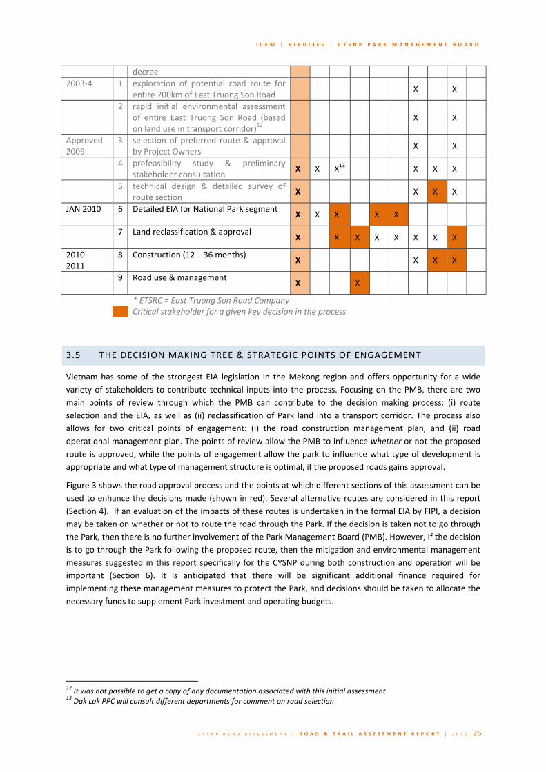
I C E M | B I R D L I F E | C Y S N P P A R K M A N A G E M E N T B O A R D
C Y S N P R O A D A S S E S S M E N T | R O A D & T R A I L A S S E S S M E N T R E P O R T | 2 0 1 0 | 25
decree 2003‐4 1 exploration of potential road route for
entire 700km of East Truong Son Road X X
2 rapid initial environmental assessment of entire East Truong Son Road (based on land use in transport corridor)12
X X
Approved 2009
3 selection of preferred route & approval by Project Owners X X
4 prefeasibility study & preliminary stakeholder consultation X X X13 X X X
5 technical design & detailed survey of route section X X X X
JAN 2010 6 Detailed EIA for National Park segment
X X X X X
7 Land reclassification & approval
X X X X X X X X
2010 – 2011
8 Construction (12 – 36 months)X X X X
9 Road use & management
X X
* ETSRC = East Truong Son Road Company Critical stakeholder for a given key decision in the process
3.5 THE DECISION MAKING TREE & STRATEGIC POINTS OF ENGAGEMENT
Vietnam has some of the strongest EIA legislation in the Mekong region and offers opportunity for a wide variety of stakeholders to contribute technical inputs into the process. Focusing on the PMB, there are two main points of review through which the PMB can contribute to the decision making process: (i) route selection and the EIA, as well as (ii) reclassification of Park land into a transport corridor. The process also allows for two critical points of engagement: (i) the road construction management plan, and (ii) road operational management plan. The points of review allow the PMB to influence whether or not the proposed route is approved, while the points of engagement allow the park to influence what type of development is appropriate and what type of management structure is optimal, if the proposed roads gains approval.
Figure 3 shows the road approval process and the points at which different sections of this assessment can be used to enhance the decisions made (shown in red). Several alternative routes are considered in this report (Section 4). If an evaluation of the impacts of these routes is undertaken in the formal EIA by FIPI, a decision may be taken on whether or not to route the road through the Park. If the decision is taken not to go through the Park, then there is no further involvement of the Park Management Board (PMB). However, if the decision is to go through the Park following the proposed route, then the mitigation and environmental management measures suggested in this report specifically for the CYSNP during both construction and operation will be important (Section 6). It is anticipated that there will be significant additional finance required for implementing these management measures to protect the Park, and decisions should be taken to allocate the necessary funds to supplement Park investment and operating budgets.
12 It was not possible to get a copy of any documentation associated with this initial assessment 13 Dak Lak PPC will consult different departments for comment on road selection

I C E M | B I R D L I F E | C Y S N P P A R K M A N A G E M E N T B O A R D
C Y S N P R O A D A S S E S S M E N T | R O A D & T R A I L A S S E S S M E N T R E P O R T | 2 0 1 0 | 26
Figure 3: The Road approval decision making tree and points of entry for the PMB
Selection of Preferred Routes
Decision on Route [Dak Lak PPC]
Through Park
Develop Road Operational
Environmental Management Plan [Project owner]
Develop Road Construction Environmental
Management Plan [Project owner]
Institutional Recommendations
(Section 6)
CYSNP Investment Plan
Financing Recommendations
(Section 6)
CYSNP Operational Management Plan
EIA Review & Approval EIA [FIPI]
Mitigation measures (Section 6)
Impacts Alternatives (Section 3‐6)
No further PMB involvement
Alternative Routing
National Decision on General Route [National Assembly]
Feasibility of Route Evaluation of Alternative Routes
Information & Preliminary Findings for Alternative Route option
(Section 4)

I C E M | B I R D L I F E | C Y S N P P A R K M A N A G E M E N T B O A R D
C Y S N P R O A D A S S E S S M E N T | R O A D & T R A I L A S S E S S M E N T R E P O R T | 2 0 1 0 | 27
4.0 Alternat ives to the Road route
4.1 REGULATORY CONTEXT
EIA legislation in Vietnam requires that alternative routes are explored for transport routes through National Parks. Further, inclusion of all stakeholder feedback in the route selection process may enhance the roads ability to meet its objectives of supporting development in the provinces and districts it passes through.
For this preliminary assessment M’Drack, Dan Kia Suoi Vang and Dalat have been identified as the control points for the route (see Map 6).
4.2 EXPLORATION TO DATE
The field mission has revealed that some preliminary assessment has already been carried out. In response to concerns raised by the PMB the construction company explored two routes which by‐passed CYSNP cutting through the Krong Bong SFE on the eastern boundary. The two alternatives were:
1. Krong Bong State Forest Enterprise route: In 2005, the Project Owners first proposed the road route through the core zone of CYSNP. However, concern raised by the PMB initiated an assessment of alternative routes. One alternative was identified passing south from Yang Mao commune through the Krong Bong SFE before turning west and connecting with the initial proposed route south of the CYSNP core zone.
A preliminary and rapid survey of this route was conducted over 3‐4days and involved both construction company staff and rangers from CYSNP. The ridge crossed high ridge lines and steep terrain which would make construction prohibitively expensive. The survey mission culminated in an MOU between the construction company and the PMB outlining this conclusion. A detailed summary of the MOU is provided in Annex 1 (Section 14.1.2).
Given the terrain, the difficulty of movement in the area and the travel times estimated in CYSNP, further more detailed analysis is required to first identify potential routes through Krong Bong SFE which avoid the steep terrain and then evaluate their potential as alternatives. To date, the exact route surveyed by the joint team and how far they travelled remains unclear. A possible alternative with more favourable terrain is described below.
2. Krong Bong Stream route: One clear alternative through the Krong Bong SFE takes advantage of the wide‐bottomed valley of the Krong Bong stream. The Krong Bong stream demarcates the border between CYSNP and the Krong Bong SFE. According to the PMB there are a number of isolated villages living in this river valley and on the outskirts of the core zone. An alternate route could follow the valley just outside CYSNP perimeter for approximately 6km before crossing a ridge lines and joining up with the original proposal south of the core zone.
The level of detail to which this alternative was assessed remains unclear, however, a number of stakeholders were aware of the proposed alternative, including the PMB. Concern for this route was raised by the PMB who felt that the route would open access to a section of the core zone boundary which had to‐date remained fairly isolated. From a biodiversity point of view this route also has some considerable drawbacks – namely that it will still divide the CYS‐BDNB forest complex, which is Vietnam’s largest remaining complex.

I C E M | B I R D L I F E | C Y S N P P A R K M A N A G E M E N T B O A R D
C Y S N P R O A D A S S E S S M E N T | R O A D & T R A I L A S S E S S M E N T R E P O R T | 2 0 1 0 | 28
4.3. OTHER ALTERNATIVE ROUTES
Despite this short exploration to identify an alternative route, which resulted in a conclusion that there was no alternative to going through the CYSNP, it has become clear that there are other alternatives that could be considered.
As part of this assessment, three other alternative routes have been identified to indicate potential transport corridors that minimize the habitat fragmentation impact on the national parks, while still meeting the objectives of the East Truong Son Road. This is made more complex because CYSNP is contiguous to Bui Doup – Nui Ba national park (BDNB) which joins CYSNP at its southern border.
The proposed road route through CYSNP exits the park at the western‐most boundary shared by the national parks (Map 6). There is already one road which passes through BDNP, road 723. Approximately 16km of Road 723 is in the core zone of BDNB, which provides a shorter route connecting Dalat with northern Vietnam. A second road (722), which passes through BDNBNP, is currently being upgraded as part of the Truong Son Road project. This means that alternatives which by‐pass the park immediately to the east have the potential to transfer impacts to BDNB. However, it also suggests that there are existing roads, which may be utilized and upgraded to both minimize further disturbance in the CYSNP‐BDNB complex, and reduce cost of road development for the East Truong Son project.
Alternative routes have been identified based on the surrounding terrain and options already explored by the construction companies. Each of these alternatives presents a different set of opportunities and risks for stakeholders.
A1. Upgrade of Hwy 694: An alternative exists in upgrading the existing poorly maintained ring road that circumvents the northern boundary of the core zone, before connecting with Hwy 27 towards Da Lat or cutting across Krong No Commune to join proposed route near the Golden River Resort (Hwy 722) (Map 6). Discussion with PMB indicates that the terrain through Krong No commune would be similar to terrain through the park with no significant increase in level of effort. To the knowledge of the project team, this route has not been explored by any of the stakeholders. However, one of the objectives of the East Truong Son Road is poverty alleviation through connecting poor and isolated communities to other parts of Vietnam. This would be well suited by upgrading Hwy 695 which would pass through 8 communes in Krong Bong and Lak districts – 6 of which have poverty rates greater than 50% (Map 4). The proposed route through the CYSNP core zone would only link up with one of these communes.
A2. Ban M’Drack ‐ Thach Trai – Da Lat: Hwy 723 currently runs through the eastern corner of BDNBNP connecting Da Lat, Thach Trai and Nha Trang. This alternative route would run south from M’Drak to Thach Trai following the valley floor.
A3. Eastern by‐pass of the CYS‐BDNB complex: Route A3 would be similar to route A2 but pass by different communes and villages. It would run south from M’Drak to the north‐eastern border of the Krong Bong SFE and then skirt south around the highlands of the Da Lat plateau before joining Hwy 723 near Thach Trai. This route is more direct than A2, but crosses steeper terrain. It is not analysed in Table 4.
Table 4 presents a comparison of the salient feature of each route and key conclusions are summarized below.
• Travel Time, M’Drack to Dalat: the proposed routes, A2 and A3 are comparable road lengths between the control points ~135km, with an estimate design travel time of ~ 1.5 – 2.0hours. A1 is approximately 50‐60km longer adding 0.5 – 1.0 hours onto travel time from M’Drak to Dalat.
• Length of new road: The proposed route requires almost twice the amount of new road construction than all alternatives. In terms of new road required, A2 and A3 are the most economical requiring 65‐

I C E M | B I R D L I F E | C Y S N P P A R K M A N A G E M E N T B O A R D
C Y S N P R O A D A S S E S S M E N T | R O A D & T R A I L A S S E S S M E N T R E P O R T | 2 0 1 0 | 29
70km of new road, while A1 requires 75‐80km. The proposed route would require 110‐115km of new road.
Table 4: Comparison of key characteristics of alternate routes between M’drak and Da Lat
Characteristic for comparison Proposed Highway Route
Alternative Route A1 Alternative Route A2
Total length of road segment 133.5Km 188.0 Km 133.1Km
average longitudinal slope (90m intervals)
8.0 Degrees 6.7 Degrees 7.4 Degrees
max longitudinal slope (90m intervals)
43.3 Degrees 36.3 Degrees 42.7 Degrees
% composition of land use disturbed (national park/protected area, agricultural, urban)
• % Agriculture 50.3% 69.9% 77.9%
• % National Park 30.5% 1.8% 15.4%
• % Proposed Nature Reserve
13.1% 9.7% 0%
• % Landscape Reserve 4.9% 11.3% 6.8%
• % State Forest Enterprise 1.2% 7.3% 0%
number of communes connected with >50% poverty incidence
11 19 12
number of cities/towns connected 4 3 3
length of new road required for construction
111.8Km 78Km 64.9Km
proportion of route utilising existing roads
16.2% 58.7%
51.3%
Estimate travel time M’Drak to Dalat based on the design speed of 80km/hr
1.5 ‐ 2.0 hours 2.0 – 2.5 hours 1.5 ‐ 2.0 hours
• Road gradient: the proposed route through CYSNP has the steepest average slope and also the highest maximum slope of 43degrees (based on 90m SRTM data). More detailed contour information and the generation of longitudinal profiles would refine this estimate to give a better comparison
• Socio‐economic connectivity: one of the stated objectives of the road is to improve socio‐economic development and reduce poverty in remote and isolated areas by improving connectivity. Map 5 presents the incidence of poverty in surrounding communes. A1 will have the greatest impact on

I C E M | B I R D L I F E | C Y S N P P A R K M A N A G E M E N T B O A R D
C Y S N P R O A D A S S E S S M E N T | R O A D & T R A I L A S S E S S M E N T R E P O R T | 2 0 1 0 | 30
communes with greater than 50% poverty incidence, while the proposed route and both A2 and A3 will each connect 10‐13communes with greater than 50% incidence of poverty.
• Biodiversity affected: almost 50% of the proposed route passes through National Park, landscape or proposed nature reserve, compared to ~25% along route A1, A2 and A3. This means that all alternative routes will have a significantly lower impact on biodiversity than the proposed route through CYSNP.
It is clear that whilst these routes are sometimes longer than the proposed route through the CYSNP, they also involve significant stretches of existing road, which would be less environmentally damaging than new road construction. In contrast these routes pass through significantly more agricultural land, which may have the cost implications of farmer compensation that a route through a National Park does not. However, when the costs of additional management and protection of the National Park are taken into account in the overall costing of the road, the one‐off compensation costs for agricultural land, may be lower than the continuing Park management costs.
4.3 RECOMMENDATIONS
It is strongly recommended that the Project Owners explore the feasibility of these and other alternative route options in greater detail than they have already done, and that these are assessed in the formal EIA undertaken by FIPI. The preliminary assessment summarized above suggests that there are alternative routes which are shorter, pass through more amenable terrain, connect more poverty stricken areas and have lower biodiversity impacts than the proposed route through CYSNP.

I C E M | B I R D L I F E | C Y S N P P A R K M A N A G E M E N T B O A R D
C Y S N P R O A D A S S E S S M E N T | R O A D & T R A I L A S S E S S M E N T R E P O R T | 2 0 1 0 | 31
5.0 Impacts of the Road For major roads and highways, impacts will occur during the design, construction and operational phases of the road, while there may be an overlap of impacts between phases and even causality (i.e. impacts in one phase may cause impacts in a subsequent phase) these impacts must be assessed separately to reflect the different time scales over which they manifest and the type of management response they require. Furthermore, infrastructure penetrating into areas which have remained comparatively isolated can both exacerbate existing threats by lowering opportunity costs, increasing the frequency with which they occur, or the area over which they are felt, as well as introduce new threats into the system.
The impacts assessment in this study are organised around an environmental component approach as used in the RIAM (Rapid Impact Assessment Matrix) methodology (Pastakia, 1996). This approach has been chosen because environmental components are well known and understood by PMB staff and allows for potentially impacting activities from the road development to be gauged against current knowledge. Table 5 adapts the RIAM to highlight the main activities of the road construction & operations process and the key environmental components that may be impacted.
5.1 THREATS AND POTENTIALLY IMPACTING ACTIVITIES
PARK MANAGEMENT THREATS
Potential threats arise where road construction/operational activities impact current environmental components (as indicated in the table above). In reality, many of the threats likely to face the national park have already been experienced at reduced scale. Therefore, a starting point for the threat inventory is to review current threats facing CYSNP. These are outlined in the Operational Management Plan (OMP) 2010‐2015 (BirdLife, 2009):
1. Hunting , trapping and fishing 2. Illegal logging 3. Infrastructure development 4. Conversion of forest into agricultural land 5. Fire & landslides 6. NTFP (Non‐timber forest products) exploitation 7. Ngo Thong exploitation 8. Cattle‐grazing 9. Scrap metal collecting
Based on international and Vietnam experience, the new threats posed by the construction of a road through CYSNP include:
10. Sand excavation and other road building materials 11. Destabilisation of hillslopes 12. Water and land pollution 13. Noise disturbance to park wildlife 14. Illegal settlements 15. Restricted wildlife movement

I C E M | B I R D L I F E | C Y S N P P A R K M A N A G E M E N T B O A R D
C Y S N P R O A D A S S E S S M E N T | R O A D & T R A I L A S S E S S M E N T R E P O R T | 2 0 1 0 | 32
Table 5: Potential impacting activities of the road construction & operations process and impacted environmental components (Adapted from (NRA,2009; Pastakia, 1995)
ENVIRONMENTAL COMPONENTS
POTENTIAL IMPACTING ACTIVITIES¹ Habita
t integrity
Habita
t quality
Habita
t con
nectivity
Species compo
sitio
n
Rare/end
angered species
Species interaction
Land
scape/aesthe
tic quality
Surface water quality
River morph
ology
Topo
graphy
& soils
Historic sites
Park accessibility
PMB fin
ancial self‐sufficiency
Eco‐tourism
National Park status
Commun
ity[1] d
evelop
men
t
Commun
ity‐CYSNP conn
ectiv
ity
BP 1
BP 2
BP 3
BP 4
BP 5
BP 6
BP 7
BP 8
BP 9
BP 10
SC 1
SC 2
SC 3
SC 4
SC 5
SC 6
SC 7
C114 vegetation & soil stripping X X X X X X X X X
C2 other earthworks X X X X X X X X X X
C3 noise & vibrations (blasting & excavations) X X X
C4 construction of structures and hard surfaces X X X X X X X X X X X X X
C5 construction of barriers to wildlife movement (berms, fences, median barriers) X X X X X
C6
construction camps (including waste disposal and disturbed area) within the core zone X X X X X X X X X X X X
C7 construction site drainage X X X
C8 air pollution & dust suppression X X X X X X
C9 cut disposal/removal X X X X X X X X X X X
C10 temporary access routes X X X X X X X X X X X
C11 Lighting X X X X
C12 movement of vehicles & machinery X X X X X X X
C13 disturbance associated with presence of construction staff X X X X X X
C14 new planting X X X X X X
C15 environmental incidents & accidents X X X X X
C16
fill and construction material stockpiling, including location of quarries and borrow pits X X X X X X X X X X
C17 Enlargement of disturbance corridor for machinery access X X X X X X X X
C18 Wildlife exploitation by construction workforce X X X
O1 traffic use X X X X X X X X X X
O2 operational drainage X X X
O3 lighting & additional infrastructure X X X X X X X
O4 management of planting/embankment stabilisation X X X X
O5 maintenance operations and scheduling X X X X X X X X
O6 rest stops/sightseeing points X X X X X X X X X X X
O7 checkpoint & access management x x X X X X X X X
14 C1‐C18 = construction phase activities, O1‐O7 = operational phase activities

I C E M | B I R D L I F E | C Y S N P P A R K M A N A G E M E N T B O A R D
C Y S N P R O A D A S S E S S M E N T | R O A D & T R A I L A S S E S S M E N T R E P O R T | 2 0 1 0 | 33
5.2 CONSTRUCTION IMPACTS
A summary of the most likely construction impacts posed by the road development is presented in table 6. This table serves as a guide for issues to be considered in greater detail during the EIA process and discussions on approval of the road route as well as on the scope and content of the EMP for construction phase activities.
Table 6: Construction phase impacts for the proposed road development
Environmental Component
Impacts during construction
Habitat integrity Access routes for worker and heavy machinery, materials storage areas and temporality erosion and pollution actions likely to cause localised fragmentation (physical barriers and local disturbance to species movements) of all habitats where the road is planned
Habitat quality Where road construction is taking place, including the strictly protected zone and more remote sections of the park, the presence of heavy machinery and worker camps will greatly reduce habitat quality via noise, litter and other pollutants, localised forest loss and degradations and potentially, intentional habitat degradation though the collecting and/or hunting of forest resources
Habitat connectivity During construction, localized habitats, as well as that of the entire Park and CYS‐BDNB complex will lose partial connectivity. Physical barriers will include the wide excavation corridor for the final road, as well as the presence of heavy machines, working camps and people that will hinder or completely halt animal movements, rendering the habitat functionally disconnected.
Species composition Construction methods, which including blasting of rocks, forest clearing, excavation and resulting erosion, noise and wastewater pollution, will have a temporary and localized impact on species composition as certain species are either killed or disturbed and thus shift to a new area
Rare/endangered species
As identified on map 7 the proposed road construction will take place in sites known to hold populations of globally important, rare and legally protected species. As with the operational phase (see table below) ribbons of destruction inside the protected area are direct threats to any biodiversity that lay in their path. They also dissect vital home ranges, especially for larger mammals, as well as interfering with important process which include finding mates, finding food (especially for animals who move locations to find different seasonal resources) and the radiation of young animals into new territories.
Species interaction In areas under construction and where normal movement or migration is temporally stopped by construction activities, species interaction will be, to a greater or lesser degree, altered. This will include predator‐prey relationships which underpin the entire functioning of the ecosystem – at all levels or scales.
Landscape / aesthetic qualities
There will be drastic, localized degradation to landscape / aesthetic qualities during construction. The extent to which these impacts reduce over time depends on the choice of construction methods and thus the ability of the natural vegetation to recover.
Surface water quality In construction areas and downstream of them, surface water quality is likely to be greatly reduced. Soil erosion associated with deforestation and excavation, and surface run‐off containing sediments and possible toxic pollutants will be flushed into all nearby waterways (and possible into ground water also). This significant reduction in quality will bring about a reduction in primary production within the surface water and subsequently lower oxygen and available food for aquatic species. The species will have only three option available to them: Adapt to water with lower oxygen, reduced visibility and higher concentrations of pollutants; move to other waterways; or perish.
River morphology River morphology will remain largely unchanged during the construction period.
Topography and soils At the local level, where digging and construction is taking place, soils that would have
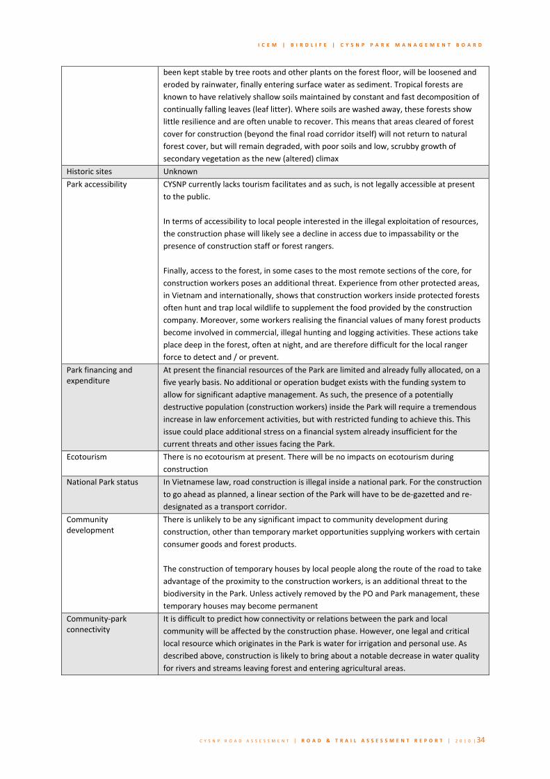
I C E M | B I R D L I F E | C Y S N P P A R K M A N A G E M E N T B O A R D
C Y S N P R O A D A S S E S S M E N T | R O A D & T R A I L A S S E S S M E N T R E P O R T | 2 0 1 0 | 34
been kept stable by tree roots and other plants on the forest floor, will be loosened and eroded by rainwater, finally entering surface water as sediment. Tropical forests are known to have relatively shallow soils maintained by constant and fast decomposition of continually falling leaves (leaf litter). Where soils are washed away, these forests show little resilience and are often unable to recover. This means that areas cleared of forest cover for construction (beyond the final road corridor itself) will not return to natural forest cover, but will remain degraded, with poor soils and low, scrubby growth of secondary vegetation as the new (altered) climax
Historic sites Unknown
Park accessibility CYSNP currently lacks tourism facilitates and as such, is not legally accessible at present to the public. In terms of accessibility to local people interested in the illegal exploitation of resources, the construction phase will likely see a decline in access due to impassability or the presence of construction staff or forest rangers. Finally, access to the forest, in some cases to the most remote sections of the core, for construction workers poses an additional threat. Experience from other protected areas, in Vietnam and internationally, shows that construction workers inside protected forests often hunt and trap local wildlife to supplement the food provided by the construction company. Moreover, some workers realising the financial values of many forest products become involved in commercial, illegal hunting and logging activities. These actions take place deep in the forest, often at night, and are therefore difficult for the local ranger force to detect and / or prevent.
Park financing and expenditure
At present the financial resources of the Park are limited and already fully allocated, on a five yearly basis. No additional or operation budget exists with the funding system to allow for significant adaptive management. As such, the presence of a potentially destructive population (construction workers) inside the Park will require a tremendous increase in law enforcement activities, but with restricted funding to achieve this. This issue could place additional stress on a financial system already insufficient for the current threats and other issues facing the Park.
Ecotourism There is no ecotourism at present. There will be no impacts on ecotourism during construction
National Park status In Vietnamese law, road construction is illegal inside a national park. For the construction to go ahead as planned, a linear section of the Park will have to be de‐gazetted and re‐designated as a transport corridor.
Community development
There is unlikely to be any significant impact to community development during construction, other than temporary market opportunities supplying workers with certain consumer goods and forest products. The construction of temporary houses by local people along the route of the road to take advantage of the proximity to the construction workers, is an additional threat to the biodiversity in the Park. Unless actively removed by the PO and Park management, these temporary houses may become permanent
Community‐park connectivity
It is difficult to predict how connectivity or relations between the park and local community will be affected by the construction phase. However, one legal and critical local resource which originates in the Park is water for irrigation and personal use. As described above, construction is likely to bring about a notable decrease in water quality for rivers and streams leaving forest and entering agricultural areas.

I C E M | B I R D L I F E | C Y S N P P A R K M A N A G E M E N T B O A R D
C Y S N P R O A D A S S E S S M E N T | R O A D & T R A I L A S S E S S M E N T R E P O R T | 2 0 1 0 | 35
5.3 OPERATIONAL IMPACTS
A summary of the most likely operational impacts posed by the road development is presented in table 7. This table serves as a guide for issues to be considered in greater detail during the EIA process and discussions on approval of the road route as well as on the scope and content of the EMP for operational phase activities. It is likely that much of the environmental management measures during this phase will be the responsibility of the Park Management Board.
Table 7: Operational phase impacts for the proposed road development
Environmental Component
Impacts during operation
Habitat integrity Within CYSNP, habitat integrity will be severely reduced by the road which creates a physical barrier to the movement of many species. Some species will not able to cross this barrier and other will avoid it due to disturbance and fear. While the forest may look intact, on either side of the road, it has actually been fragmented into sections – see map 8 and section 5.4.2 (SLOSS) – essentially creating several smaller forest pieces / disjunctive protected area.
Habitat quality Habitat along and adjacent to the road route will never recover. Ribbons of deforestation will remain and changes in light, soil quality and hydrology will mean the forest can never fully re‐grow. For many species which depend on an intact canopy, no disturbance or are very vulnerable to hunting, this reduction in habitat quality poses a significant additional risk
Habitat connectivity The proposed road will destroy the connectivity and integrity of the CYS‐BDNB protected area complex as it currently exists. The route taken by the road completely annexes the southern park and puts in place a barrier which few species, beyond those that can fly, can cross. The road surface, including drainage channel, shoulder and embankments will range from 10m up to 60m depending on topography. This alone will stop most animals, but when traffic is added to this national highway and subsequent road kills, disturbance and greater human access (for illegal hunting and logging), the road becomes an impenetrable wall. The value of CYSNP, as a vital protected forest, is interconnected with the values of BDNBNP – the two parks are a single ecosystem, which the proposed road will functionally destroy.
Species composition Species composition is not consistent throughout the Park. While the entire protected area is of the highest conservation vale, habitats and values are not homogenous. For example, particular rivers will be of critical important for amphibians while another area of rich, primary forest with particular fruiting trees will be essential for gibbons. As such, road bisecting the Park will have significant impacts on species composition. We can already see (maps 7 and 8) that the proposed road will pass through key habitats for primates and herpetofauna
Rare/endangered species As identified on map 7 it is clear that the proposed road will cut through the core of two gibbon family group territories and affect others. Moreover, map 8 which demonstrates the Zones of Influence created by the developments, shows wider impacts, caused by human access and restriction of animal movements, effecting black‐shank doucs, sun bears and areas of primary forest vital for rare birds, reptiles and amphibians. Large mammals tend to be rarer due to the need for more space, lower natural density and hunting pressure. These species depend upon large areas for finding food, breeding and raising young. The fragmentation of CYSNP by the road, the human access issue and the end of connectivity / ecosystem function with BDNBNP will have grave consequences for the Park’s primates, ungulates and carnivores.
Species interaction As highlighted under the impacts during construction, the interaction of species – from

I C E M | B I R D L I F E | C Y S N P P A R K M A N A G E M E N T B O A R D
C Y S N P R O A D A S S E S S M E N T | R O A D & T R A I L A S S E S S M E N T R E P O R T | 2 0 1 0 | 36
seed dispersal to herbivorous consumption of plants and carnivorous consumption of other animals, is the mechanism by which energy flows through ecosystem – it is the basis for life in the forest. The fragmentation and disturbance caused by the developments will have far reaching consequences for the interaction of some species. While it is difficult to predict which species and win what ways, it is likely that some (possibly many) species will be separated from other species on which they depend for food, cover or rest.
Landscape / aesthetic qualities
There will be lasting landscape impacts caused by the road. At present CYSNP is a site of unbroken forest, free from overt signs of human activity.
Surface water quality During operation, in terms of erosion and suspended sediment, after all embankments are fully stabilised, surface water quality will return to normal. However, there is a risk that severe weather events could create unstable soils where forest has been removed, leading to renewed erosion or even landslides. The extent to which this happens (or not) depends on construction techniques and mitigation. Finally, there is a further risk of toxic pollution / heavy metal contamination from motor vehicles, impacting on the terrestrial and aquatic environments. Road run‐off contains a cocktail of environmental pollutants, which ultimately find their way into local streams and rivers. Pollution arises from a number of areas, namely:
‐ during combustion of petroleum products (e.g. carbon monoxide, carbon dioxide, un‐burnt hydrocarbons, etc);
‐ wear and tear of the vehicle ‐ particulate material from the vehicle, e.g. rust (iron), metals, soot, inorganic salts, tars, etc, and;
‐ wear and tear of the road ‐ metals and hydrocarbons are known to emanate from the wear of road construction material.
River morphology During operation, culverts, draining channels and changes to storm overland flow and discharge are likely to affect to morphology of the river. Furthermore if any large scale barriers or bridges are planned these too will affect currents with subsequent downstream impacts on erosion and depositional processes.
Topography and soils Ongoing changes to soil and topography will not continue after construction, unless the road has significant alterations to hydrology that has knock‐on effects to overland flow. Soils lost during the construction process will not recover and the corridors of development along and immediately surrounding the developments will remain degraded.
Historic sites Unknown
Park accessibility For tourism purposes, the road would provide new access and opportunities. For local people, and possibly outsiders, engaged in illegal exploitation of forest resources the road will increase accessibility enormously. Core and remote areas of the Park are currently a two or even three day walk from outlying villages. In terms of contractors, access issues will cease at the end of construction.
Park financing and expenditure
As for the construction phase, only more so, the Park will have to find or divert a significant amount of funding to bolster law enforcement efforts once the road is complete ‐ See section above on Park accessibility Also, a reduction in wildlife resulting from ecological disturbance and hunting, especially popular and observable species like primates may lead to reduction in the potential for generating ecotourism revenues ‐ that could prove to be considerable.
Ecotourism The road will have a negative impact on tourism values of the Park, with many visitors

I C E M | B I R D L I F E | C Y S N P P A R K M A N A G E M E N T B O A R D
C Y S N P R O A D A S S E S S M E N T | R O A D & T R A I L A S S E S S M E N T R E P O R T | 2 0 1 0 | 37
wanting to see an unspoiled ‘wilderness’, not a forest bisected by a national highway. The displacement or loss of key species may threaten the basis for developing ecotourism. Primates are popular and diurnal, making them ideal target species for ecotourism. The road, however, will place enormous additional pressure (due to loss of habitat and hunting) on gibbon groups
National Park status See Table 6. This loss of a section of the Park’s status is a serious loss to the Park itself, to the entire integrity of the CYS‐BDNB complex and to conservation in Vietnam. The loss of status, for just a section of the park, provides a disturbing precedent for the value of biodiversity and ecosystem services in the face of other competing values. The worry for forest protection managers is that this undermines the entire concept of protected areas in the province and nation as a whole, and opens the door to more and more damaging de‐gazettement processes ‘in the national interest’. The area lost to the road corridor also extends beyond the boundary of the park, as described earlier, essentially destroying the integrity of this, the most important protected forest complex in the Da Lat Plateau, the Southern Annamites and possibly all of Vietnam.
In‐migration, community development
Roads tend to attract new housebuilding along the route. Inside the Park, the presence of new houses and communities near the road would be very damaging and would pose a continued threat to the Park’s biodiversity from hunting and the wildlife trade. As has been the case in BDNBNP, the Park would be negatively impacted by illicit lands claims, land grabs and spontaneous construction. The disturbance to the current local economy, potentially associated with greater in‐migration to the area, may lead to land inequality and new pressures on the forest itself. These processes will probably begin during construction phase.
Community‐park connectivity
See Table 6.
5.4 PRIORITY IMPACTS
Of the numerous environmental impacts highlighted above, the threats to habitat integrity and connectivity, the direct impacts on rare and endangered species and increasing access to the Park are interconnected and of the greatest concern to biodiversity in CYSNP. The road will allow motorised transport into what is currently the remote core of the protected forest. It will reduce transport times into and out of the forest from days to a matter of hours, and facilitate the removal of more and larger forest products with a greatly reduced amount of effort.
The road forms a physical barrier to the movement, interaction and critical life processes of many species, especially the larger mammals and more range‐restricted or specialised species. Even where animals many be physically able to cross a wide expanse of embankments and surfaced road, traffic mortality, noise and fear will prove to be major obstacles. As such, the proposed road development will turn the once contiguous forest of CYSNP into a mosaic of partially isolated forest islands, between which the exchange of genetic material is reduced and in some cases stopped altogether. For large mammals, especially gaur, gibbons, doucs and forest cats, this islandisation and isolation could prove terminal in the long run – resulting in localised extinction. This fragmentation is repeated on a massive scale by the road splitting CYSNP off from BNNBNP. This single forest ecosystem is one of the largest in Vietnam and is essential for the long term survival of larger animals and many endemic species. Where animals are able to survive in isolated fragments of forest, the presence of noise, pollutants and most critically, increased hunting/logging activity could form a mix that brings many already threatened species to extirpation or extinction.

I C E M | B I R D L I F E | C Y S N P P A R K M A N A G E M E N T B O A R D
C Y S N P R O A D A S S E S S M E N T | R O A D & T R A I L A S S E S S M E N T R E P O R T | 2 0 1 0 | 38
5.4.1 ZONES OF IMPACTS AND INFLUENCE
The construction of the road will cause a direct loss of forest cover and biodiversity along a 75 m wide corridor of the route. Beyond this corridor is the further threat of increased disturbance and exploitation caused by new access points, routes and reduced travel times into and within the forest. These secondary impacts can be quantified and analysed by assigning them to measurable zones of influence (ZOI) lying on either side of the road.
METHODOLOGY
The ZOI are based on the concept of diminishing impacts from a central line of the road or trail15. The road itself is considered a zone of direct impact, with an average width of 75m, where all biodiversity will be lost. The ZOI concept is designed to capture and identify impacts deeper into the forest from the road. For the purpose of quantification, the ZOIs were divided into 3 categories (zones): 1) Impacts within 1km of the road/trail; impacts within 5km of the road/trail; and impacts within 10km of the road/trail. These distances approximately represent the time required for a local person to move through the forest to exploit the natural resources (see Table 8). They thus correlate to increasing effort required. The further into the forest, the greater the amount of time expended and lower frequency with which the forest will be disturbed. However, a stepped approach which groups the impacts into zones is required for calculations of the areas impacted.
These zones show that beyond the forest lost to construction, the road will greatly improve access to the forest core, by reducing journey times (for hunting and logging) from several days down to a matter of hours. This will result in new threats and intensification of existing threats analysed below.
Table 8: Characterization of the Zones of Influence for CYSNP
Distance from Road
Zone Human penetration Impact
0‐75m Transport corridor
Accessible by vehicle¹ Surfaced route / Total loss of biodiversity
<1km Direct threat Within 1‐2 hours walk from the road/trail
Very high potential for drastic loss of forest cover and biodiversity
1‐5km High threat Within half a day walk from the road/trail
High potential for extensive loss of biodiversity
5‐10km Medium threat
Within a day round trip from the road/trail
Potential for loss of biodiversity
PROPOSED ROAD ZOIS – FOREST COVER AND INTERNAL ZONING
An analysis of forest cover and internal zoning in CYSNP show that the majority of the road will cut though primary forest (see map 7) and the park’s Strictly Protected Zone (SPZ) (see map 1). 79% or road is inside the SPZ and the remaining 21% in the ecological rehabilitation zone:
15 This methodology describing zones of influence is applicable to the impacts of both the road and the trails

I C E M | B I R D L I F E | C Y S N P P A R K M A N A G E M E N T B O A R D
C Y S N P R O A D A S S E S S M E N T | R O A D & T R A I L A S S E S S M E N T R E P O R T | 2 0 1 0 | 39
Table 9: Length of the proposed road route passing through CYSNP internal zones
ZONE KM STRICTLY PROTECTED 28.58 (78.6%) REHABILITATION 7.77 (21.4%) TOTAL 36.35
Table 10 shows that 59.7% of the entire SPZ of CYSNP will be influenced by the road of which 0.35% will be lost completely (0‐75m impact zone) and a highly significant 6.4%, or 3,815ha of largely remote, core forest, will be within a 1‐2 hours walk of a surfaced road (1km ZOI). The cumulative influence of all ZOIs will also cover 62% of Park’s primary forest. For the 1km ZOI, where impacts are most likely and will be most serve, 62% of the area coved (influenced) is primary forest.
Table 10: Percentage of SPZ influenced by ZOIs16
ZONE PROPOSED ROAD ZOI
HECTARES (ha) %
SPZ 75 m 206.88 0.35 SPZ Road to 1 Km 3,815.38 6.43 SPZ 1km to 5 km 8,025.66 13.53 SPZ 5km to 10 Km 23,378.29 39.42 TOTAL ‐ 59,308.36 59.73
Figure 4 shows a pie chart of the proportion of different forest areas that now lie within a day’s walk of the road. It shows that 48% of the Park’s primary forest will now be within a days walk from the road.
Figure 4: proportion of CYSNP within 1 days access from the proposed road corridor
16 ZOIs and ha totals were calculated in 3D (actual surface area taking into account topography) and so are higher than the 2D figures usually referenced for area totals
37%
15%
37%
11%0.01%
Agriculture / Other Land
Primary Forest (High Value/Mature Trees)
Primary Forest (Mixed)
Degraded / Regenerating Forest
Total area outside 1 day of access
I C E M | B I R D L I F E | C Y S N P P A R K M A N A G E M E N T B O A R D
C Y S N P R O A D A S S E S S M E N T | R O A D & T R A I L A S S E S S M E N T R E P O R T | 2 0 1 0 | 40
PROPOSED ROAD ZOIS – IMPACT UPON RARE AND ENDANGERED SPECIES
Biodiversity surveys are not complete for the park, but it is already clear that the planned road (0‐75m) will destroy areas of habitat of key species. For example, the road itself will pass directly through the known home ranges for at least two family groups of Yellow cheeked crested gibbon Nomascus gabriellae, an endangered species (IUCN 2009) and one that is, like all the large mammals mentioned in this section, legally protected in Vietnam (Decision 32).
Within the 1km ZOI, where access will be reduced to 1‐2 hours and the associated impacts are likely to be high, there are six records of large mammals including two gibbon groups and a large Indian civet Viverra zibetha (IUCN status: Near threatened).
Within the 5km ZOI there are a further nine records of large mammals, including three sites for Gaur Bos gaurus (IUCN status: Vulnerable) and three further family groups of gibbons.
Within the 10km ZOI there are an additional fifteen locations where large mammals have been recorded, including the known home ranges of further species of highest conservation importance, including black‐shanked douc langur Pygathrix nigripes (IUCN status: Endangered), sun bear Helarctos malayanus (IUCN status: Vulnerable) and four further locations of gibbon families. In total, 30 sites where large mammals – from more than six key species – have been recorded will be influenced by the road; this covers the range all known records (30 to date) of large mammals in CYSNP.
It is clear, therefore, that proposed road will destroy key habitats and the home‐ranges of key species, in addition to worsening access / exploitation deeper into the park and cutting off migration and gene flow to BDNBNP.
Finally, it is important to note that interviews with park staff revealed that the road construction company has requested to begin construction of the road segment passing through the park buffer zone before the completion of the EIA. This was rejected by the PMB who demanded that all construction follow the proper procedures. Also in Dak Lak Province, Yok Don National Park is currently trying to cope with a similar situation. Although the situation is worse at that site, with the construction company begging road construction against the express decision of the PMB to halt forest clearance / excavation.
5.4.2 PROTECTED AREA INTEGRITY
Habitat integrity plays a critical role in maintaining the national and global values and ecosystem services of CYSNP. The forest is dependent upon the existence of an intact food web, in which every species plays a part and has niche to which it is adapted. All these species are interdependent upon each other. Carnivores cannot exist without herbivores and without herbivores the plants and trees upon which all life depends will diminish in diversity as the natural balance is upset, competition between species shifts and crucial seed dispersal, and other mechanisms, are lost. Essential to these relationships and dependencies is an intact, single forest block. Larger mammals, like forest cats, cannot survive in small, isolated patches of forest, for example, with long‐term knock‐on and multiplier effects for other species further down the trophic ladder.
Aside from the loss of large mammals by losing habitat integrity and connectivity, there are also impacts on total biodiversity. The notion of how protected area size effects species diversity has been conceptualised by SLOSS – Single Large Or Several Small. This tool analyses the costs and benefits of having one large protected area or several small (fragments). The concept is underwritten by the science of island biogeography, which essentially states that the number of species on an island (of habitat) represents an equilibrium between extinction and colonisation. The species richness at equilibrium depends on the area and its isolation.

I C E M | B I R D L I F E | C Y S N P P A R K M A N A G E M E N T B O A R D
C Y S N P R O A D A S S E S S M E N T | R O A D & T R A I L A S S E S S M E N T R E P O R T | 2 0 1 0 | 41
The smaller the area (with size reduced via fragmentation) and the more isolated the area (the distance from each fragment and from other protected areas) the higher the disequilibrium and the lower the species richness. It is true that some species benefit from having more ‘edge’ and less ‘core’ to protected areas, especially species that flourish at margin of different habitats and where biodiversity and ago‐biodiversity converge. However, these benefits are overshadowed by the increase in access (for hunting and logging) that will accompany fragmentation (or Several Small PAs / a higher ratio of edges to core zone).
This degradation can be further developed by the possibility of a reduced gene pool ‐ with fewer breeding and disbursement opportunities due to a smaller habitat or constrained home ranges and barriers to migration. This process, in turn, can lead to inbreeding and eventually lower survival rates and eventual extirpation or extinction.
Further, protected areas are rarely sufficiently large, undisturbed and intact to function as a completely natural ecosystem without any management. This means that smaller and more fragmented PAs require a greater investment of resources into management just to achieve sustainable, natural processes. A larger PA requires fewer inputs and provides more befits, for less human investment.
The presence of a road inside the Park will potentially reduce the effectiveness of law enforcement: 1) The internal ‘opening up’ of the national park via new access points and reduced time and effort needed to access the forest; and 2) The creation of more options, which are thus harder to police, for getting forest products to markets or traders and in less time.
5.4.2 IRREVERSIBLE OR IRRETRIEVABLE IMPACTS
CYSNP was gazetted for its outstanding biodiversity values. It is recognised in Vietnamese law that these values should be protected for the national good, in perpetuity. Biodiversity underpins ecosystem functions that are locally essential, like maintaining the Sre Pok river for fisheries and irrigation, and internationally important with regard to climate change mitigation via CO2 absorption. The Vietnamese government, assisted by the national and international conservation community, also recognises the value of the forest in supporting local livelihoods at present and in the future, and as a source of potential genetic material for as yet undiscovered pharmaceuticals. The forest’s living resources are also the basis for adaptation to a changing climate and ongoing evolutionary processes. Most importantly, these values, which are now recognised internationally, are the irreversibly threatened by the road. Tropical forests in Vietnam hold the nation’s highest biodiversity and have been evolving in situ since the end of the last Ice Age, around 10,000 years ago. Despite the ability of forest cover to return after clearing, it is not possible for the entire interconnecting web of life to return. Logged or heavily degraded forests are of lower biodiversity than undisturbed areas, even if vegetation is maintained. Moreover, larger mammals and range‐restricted endemic species, which are most at risk from extinction due to large habitat requirements and a lack of alternative habitat or isolation, respectively, are extremely difficult to reintroduce once they are extirpated or driven to extinction. Fragmenting the forest by bisecting the park with a road and splitting CYSNP from BDNBNP will cause irreversible damage to the entire ecosystem. These developments will bring about a weakening of species interactions; breaking the links that facilitate the flow of energy through the system, as well as exacerbating existing threats to vulnerable and endangered species, possibly driving them to extinction. There are are a range of socio‐economic forces that make forest degradation and biodiversity loss permanent, by altering ecological processes beyond a threshold for recovery. Firstly, once built, at great expense, the road is permanent; it is extremely unlikely to be decommissioned, removed and more money spent of ecological
I C E M | B I R D L I F E | C Y S N P P A R K M A N A G E M E N T B O A R D
C Y S N P R O A D A S S E S S M E N T | R O A D & T R A I L A S S E S S M E N T R E P O R T | 2 0 1 0 | 42
restoration. If built as planned, the road will be an enduring barriers to animal movement and provide illegal access points to the forest of CYSNP. Secondly, roads have a tendency to pioneer the creation of secondary trails, roads and even settlement. As is the case in other Vietnamese protected areas, and in forests throughout the world, the presence of a road often leads to new trail heads, tourism infrastructure and local housing. In Cuc Phuong National Park, for example, the central road that bisects the park has facilitated the creation of a man‐made tourism lake, three areas of tourism accommodation, three restaurants, kiosks, and convention centre, car park, a second road and numerous trails and access points for both tourists and forest violators. Finally, outside the park, as has been the case in BDNBNP, roads create new opportunities for local entrepreneurs. Land prices increase where roads are built and even where land is not for sale, illegal land claims and developments take place. These settlements and small business, based around tourism and/or forest resource use exploitation (e.g. the sale of orchids or wildlife meat), make the removal of the road less and less likely over time. Squatter settlements can become permanent and illegally settled land may become officially recognised after some years and with certain payments. In these cases, the initial infrastructure constitutes the framework on which other social processes evolve and become established – giving the road, and associated impacts to biodiversity, additional potency and permanence. Development places more pressure on finite local resources, encourages further in‐migration and can lead to increased illegal forest resource use as the more marginalised members of the community are squeezed out, both economically and physically.

I C E M | B I R D L I F E | C Y S N P P A R K M A N A G E M E N T B O A R D
C Y S N P R O A D A S S E S S M E N T | R O A D & T R A I L A S S E S S M E N T R E P O R T | 2 0 1 0 | 43
6.0 Recommendat ions for road mit igat ion and EMP In the hierarchy of environmental impact management, the first level of mitigation is avoidance. If it is possible to avoid the route going through the Park, then this option should be taken. It is therefore very important that the options for alternative routes that avoid the Park are thoroughly explored.
However, if the decision is taken to route the road through the CYSNP in preference to other alternative routes, then a detailed Environmental Management Plan that addresses the specific threats within the Park needs to be agreed with the Project Owners and the CYSNP Park Management Board.
This Environmental Management Plan can be divided into three parts:
• Detailed design
• Construction and
• Operation
These are discussed below.
6.1 MITIGATION MEASURES FOR ROAD DETAILED DESIGN
The key impact to address in the detailed design phase is the loss of connectivity between the parts of the park that will be divided by the road. The design of the route should consider which animals will need to move from one side to the other across the road without disturbance and loss of life. This will require detailed mammal and bird surveys along the proposed route to identify:
• The important locations and patterns of movement of the key species of mammals and birds
• Possible deviations of the route to avoid particular habitats important for rare and endangered species
• The most appropriate locations of artificial crossing points
• The most appropriate designs of artificial crossing points e.g. bridges and tunnels
Once these locations for crossings or deviations have been identified, the Project Owner will prepare and cost detailed designs for incorporating these mitigation measures into the construction plan.
If some important/unique habitats can not be avoided by the route or are partially destroyed, some special protection measures may be required for use during the construction phase, e.g. timing or seasons to avoid, restriction of blasting, careful construction traffic management, monitoring of illegal logging and other activities etc. The identification of sites for the safe disposal of cut materials should also be carried out in the detailed design stage, so that key habitats are not destroyed by their disposal.
Designs should also include the location of checkpoints and additional ranger stations.
6.2 MITIGATION MEASURES FOR CONSTRUCTION PHASE
Table 11 shows some recommendations for mitigation and management of potential impacts resulting from construction activities of the road inside the Park. Some of these are general to all road construction activities and some are specifically designed to minimize the threats to the park itself. It is anticipated that some of these should be implemented by the road contractors, and some by the Park Management Board.

I C E M | B I R D L I F E | C Y S N P P A R K M A N A G E M E N T B O A R D
C Y S N P R O A D A S S E S S M E N T | R O A D & T R A I L A S S E S S M E N T R E P O R T | 2 0 1 0 | 44
Table 11: Recommendations for construction phase mitigations measures & minimum substantive requirements for road construction EMP
Construction activity Potential impacts
Possible mitigation and management measures
vegetation & soil stripping
• Clearance and loss of trees, understory vegetation along the 60m wide corridor of the road
• Burning of cleared vegetation and risk of forest fire
• Dumping of surplus soil and rock on areas alongside of the road or in specific dumps resulting in degradation and loss of habitat
• Soil stripping near water courses can cause high sediment loads in rivers, leading to degradation of the water quality and habitat integrity of the rivers and streams
• Loss of vegetation in corridor is absolute and can not be mitigated.
• Prevent logging and vegetation clearance in wider areas than the designated corridor
• Establish a timber certification process to ensure that all timber leaving the park only comes from the agreed corridor
• Burning of cleared vegetation under controlled conditions – clearing fire breaks around the fires, having first response fire fighting equipment easily available
• Set aside and store topsoil for rehabilitation • Use as much removed soil and rock as fill materials.
• Prohibit disposal of soils into or on slopes near rivers and streams
• Control soil moving with especial care near water courses
cut disposal/removal
• The disposal of surplus cut materials can cover areas causing loss of vegetation and degradation of habitat
• Wherever possible, surplus cut materials should be disposed of outside of the Park
• Identify and agree with Park management, specific sites for surplus soil and rock disposal to cause minimum damage and loss of habitat in the park
• Park management to monitor disposal of cut materials
fill and construction material stockpiling, including location of quarries and borrow pits
• Quarries for rock for fill and for sub‐base materials lead to loss of habitat
• Stockpiles of road building materials may slump and cause sediment discharge to water courses
• If possible all quarries and fill materials should be sourced from outside of the park
• Identify and agree with park management the locations for quarries for rock and fill materials, and for sub‐base, to minimise the loss of habitat
• Locate stockpiles of construction materials appropriately to minimise the risk of slippage and discharge into water courses
other earthworks
• Landslides and slips caused by earthworks cause loss of habitat, damage to vegetation cover and loss of habitats and water quality in rivers and streams
• Slopes to be designed to good design practice to minimise the risk of landslides according to the conditions; slopes should be stabilised as soon as possible after exposure
noise & vibrations (blasting & excavations)
• Construction traffic noise and vibrations disturbs wildlife and creates an exclusion zone along the construction alignment; prevents free movement of wildlife
• Blasting of rock along the road alignment and in quarries frightens and disturbs resident populations of wildlife, drives them away; and inhibits breeding
• Disturbance due to construction traffic noise and vibrations can not be completely mitigated.
• Confine construction work to daylight hours only when working inside the park, no night‐time work permitted
• Manage blasting requirements carefully and confine blasting operations to specific times during daylight, avoiding early morning and early evening
movement of vehicles & machinery
• Construction traffic causes disturbance of wildlife, reducing free movement
• Disturbance due to construction traffic can not be completely mitigated.
• Park management to monitor disturbance of wildlife and draw excessive disturbance of wildlife to attention of contractors

I C E M | B I R D L I F E | C Y S N P P A R K M A N A G E M E N T B O A R D
C Y S N P R O A D A S S E S S M E N T | R O A D & T R A I L A S S E S S M E N T R E P O R T | 2 0 1 0 | 45
Construction activity Potential impacts
Possible mitigation and management measures
construction of structures and hard surfaces
• Mixing of concrete and cleaning of concrete making equipment can lead to spillage, especially damaging to watercourses and toxic to aquatic life
• Locate concrete making operations away from water courses
• Manage the formation of concrete structures carefully to minimise spillage, especially bridges, culverts etc. near water courses
construction of barriers to wildlife movement (berms, fences, median barriers)
• Berms, fences and median barriers can prevent free movement of wildlife, migration of animals from one side of the road to the other
• Drainage ditches alongside the road can be a barrier to some species
• The use of barriers such as berms, and fences on the side of the road should be carefully considered and if necessary, strategically placed gaps in the structures provided to allow the passage of wildlife across the road
• Drainage ditches may be covered at regular intervals to allow passage of species that can not cross
• Incorporate special underpasses into the road design/construction for species that will have difficulty crossing the road, or be killed by passing traffic
• Park management to advise on the need for wildlife passage requirements, identifying key locations, species and seasons etc.
construction camps (including waste disposal and disturbed area) within the core zone
• Construction worker camps cover and cause loss or degradation of areas of habitat in the Park,
• The waste from construction camps (sewage, waste waters and solid wastes can cause pollution or contamination of land and watercourses
• Locate all construction worker camps outside the Park, and transport workers to the site each day
• If there is a compelling reason why construction camps have to be located inside the park, the sites and facilities should be discussed and agreed with the Park management. The “footprint” of the camps should be kept to a minimum
• All liquid wastes from construction camps must be treated to an appropriate high standard before discharge
• Al solid wastes from construction work camps should be removed from the site on a regular basis (at least once per week) for disposal outside Park boundary
• Park management to monitor waste disposal and water quality of water courses on a regular basis
construction site drainage
• Drainage from construction sites can give rise to high sediments being discharged into water courses
• Appropriate management of earthworks to minimise release of sediments into water courses
•
air pollution & dust suppression
• Exhausts from mechanical equipment – generators, motor vehicles etc. create localised air pollution
• Dust from earthworks during the dry season, covers vegetation and reduces growth
• Maintain mechanical equipment to minimise poor quality exhaust
• Use dust suppression measures in areas with regular traffic and earthmoving to minimise spread of dust onto park vegetation
Enlargement of disturbance corridor for machinery access and temporary access routes
• Construction access roads can increase the area of land degraded beyond the road corridor
• Minimise the area of landtake for access roads
• Rehabilitate access roads after construction has finished by appropriate landscaping and planting with indigenous plant species as agreed with Park management
Lighting • Lighting around construction sites for
work at night can cause disturbance to wildlife
• Construction work at night in the Park should not be permitted, so there should be no need for significant artificial lighting

I C E M | B I R D L I F E | C Y S N P P A R K M A N A G E M E N T B O A R D
C Y S N P R O A D A S S E S S M E N T | R O A D & T R A I L A S S E S S M E N T R E P O R T | 2 0 1 0 | 46
Construction activity Potential impacts
Possible mitigation and management measures
• Lighting of construction camps can
cause disturbance to wildlife • If construction camps have to be located inside the park, camp lighting should be kept to a minimum, as agreed with Park management
• Park management to monitor potential disturbance of wildlife due to lighting
new planting
• Inappropriate planting and revegetation of construction areas (roadside verges, banks and rock faces, quarries, access roads and construction camps) can lead to: o Introduction of invasive species o Loss of landscape value
• Wherever possible areas of land exposed by the construction work should be rehabilitated, by appropriate landscaping and replanting
• Topsoil removed from earthworks should be carefully stored, retaining any seeds in the soil for later rehabilitation work
• No exotic species should be planted, • A seedbank of the vegetation in the park should be set up before construction starts for use in final replanting
• Park management to agree rehabilitation plans and monitor implementation
environmental incidents & accidents
• Spillage from storage areas of fuel and oil, can give rise to contamination of land and watercourses
• Spillage of toxic construction materials And supplies, can cause toxic hazard in water courses and poison areas of land
• Protective bunds around fuel and oil stores to limit the spread of spilt fuel and oil
• Controlled access to stores of toxic materials, and careful (trained) management in their use; awareness of risks
• Preparation of a spill response plan and staff training in its implementation
disturbance associated with presence of construction staff
• The presence of construction workers may disturb wildlife preventing wildlife movement, feeding and breeding
• Restrict access of construction workers to the construction sites and workers camps
• Provide awareness and training for workers on the impacts of disturbance on wildlife
Wildlife exploitation by construction workforce
• Construction workers may hunt for food or wildlife trade and collect non‐timber forest products from the forest
• Employment rules for construction workers should include prohibition of hunting and collection of NTFP
• Provide awareness and training for workers on the impacts of hunting on wildlife
• Park management should monitor hunting activities around construction camps, with increased patrols around camps
6.3 MITIGATION MEASURES FOR OPERATIONAL PHASE
If the road is constructed within CYSNP as currently planned, then continuing mitigation measures will be essential to minimise risks and reduce damage during the operation phase. The key impacts can be broadly defined as increased human access for illegal activity, and habitat fragmentation and loss of connectivity. For both of these critical and and often irreversible impact groupings, the following essential mitigation measures, should be incorporated into the Park Management Plan, with additional funds allocated from the Road Project owners:

I C E M | B I R D L I F E | C Y S N P P A R K M A N A G E M E N T B O A R D
C Y S N P R O A D A S S E S S M E N T | R O A D & T R A I L A S S E S S M E N T R E P O R T | 2 0 1 0 | 47
Table 12: Recommendations for road operational phase mitigations measures & minimum substantive requirements for an operational EMP
Threat (grouped)
Mitigation measure
INCR
EASED ACC
ESS
1. Checkpoints and road barriers at each end of the road at the park boundary to be established before construction begins 2. Undertake stop and search procedures for vehicles at checkpoints both randomly and based on information from informants, investigations and ranger suspicions 3. Construct an additional ranger station specifically for law enforcement / staff activities along the road 4. Augment the current forest protection staff with additional rangers 5. Provide training for park managers and rangers on the specific risks associated with roads and procedures necessary to reduce risks and maintain forest protection 6. Undertake regular patrols, with a changing (unpredictable) routine both by vehicle and on foot along the road 7. Establish patrol routes inside the forest near the road and where any trails are visible – undertake regular forest patrols 8. Increase cooperation between CYSNP, Ministry of Defense (especially local army authorities), local police, local hydropower company, BDNBNP managers and Provincial Forest Protection Departments of Dak Lak and Lam Dong to establish joint patrols and forest crime investigations
FRAGMEN
TATION
1. Ensure the road design contains measures to facilitate and maintain natural movement and migration of animals 2. Maintain and keep free from disturbance elevated sections of road (flyovers), wildlife underpasses / tunnels, natural over‐passes to allow animals to walk over the road within natural vegetation, as well as artificial bridges and ropes to promote arboreal connectivity – see annex XX & box above 3. Concentrate law enforcement activities at wildlife pathways to avoid creating a hunting bottleneck or hotspot 4. Shut the road inside the Park at night between 23:00 and 05:00 5. Protect from disturbance areas known to be critical for rare or endangered species – These will be identified at the detailed design stage by biodiversity surveys along and near the proposed route.

I C E M | B I R D L I F E | C Y S N P P A R K M A N A G E M E N T B O A R D
C Y S N P R O A D A S S E S S M E N T | R O A D & T R A I L A S S E S S M E N T R E P O R T | 2 0 1 0 | 48
Essential to all mitigation measures, and most acutely with any that involve the use of law enforcement as a deterrent and crime fighting tool, is the need for adequate training for all staff (see Table 12) and effective communication between all levels of park staff (to ensure that orders flow from managers down to rangers and information flows back up). Training should be provided in anticipation of the road construction, orienting and guiding the staff to the increased threats and management responsibilities.
Good communication will underpin flexible, iterative and adaptive management. This approach will facilitate effective law enforcement by allowing park staff to discover and react quickly to threats and changes as they evolve, and will also facilitate managers to be able to monitor the activities of rangers and avoid (or reduce) possible incidents of bribery or corruption.
In addition, managers should require patrol staff to undertake daily monitoring of wildlife and crime in the forest (as is already developing in CYSNP), including the use of GPS location records, to produce monthly patrol reports. Rangers should also take photographs on all patrols to record wildlife, violations and ranger activities. These sources can be cross referenced later to: 1) Build a case against forest criminals; 2) Examine trends in wildlife and wildlife crimes; and 3) Monitor and evaluate the activity of rangers. It will be important to show rangers that this information can be used to evaluate their performance, but without implying they are complicit in wildlife crime. Further, to bolster enthusiasm for forest protection work, rangers require incentives in the form of increased salaries (these are currently low) and other motivations, such as a ‘ranger of the year’ programme, established to award a ranger or group of rangers with a prize for outstanding efforts – as piloted in Cuc Phuong National Park.

I C E M | B I R D L I F E | C Y S N P P A R K M A N A G E M E N T B O A R D
C Y S N P R O A D A S S E S S M E N T | R O A D & T R A I L A S S E S S M E N T R E P O R T | 2 0 1 0 | 49
PART C: THE TRAILS

I C E M | B I R D L I F E | C Y S N P P A R K M A N A G E M E N T B O A R D
C Y S N P R O A D A S S E S S M E N T | R O A D & T R A I L A S S E S S M E N T R E P O R T | 2 0 1 0 | 50
7.0 Descr ipt ion of the Tra i l network
7.1 EXISTING NETWORK & INSTITUTIONAL CONTEXT
There are 27‐30 existing trail access points into the core zone of CYSNP, providing access to most areas of the core zone. The trails are single‐lane earthen paths which are often partially obscured by overgrowth of bamboo and underbrush.
Many of the trails originated more than 30years ago at which time there were people living within the core zone. Since these settlements were evacuated by 1982, trails have been maintained through regular use by the PMB staff. The field mission revealed that bamboo and forest understory frequently overgrow across the trail paths and patrol troops typically clear bamboo overgrowth aas required.
Decisions on upgrading existing trails or adding new trails fall under the mandate of the PMB and should be expressed in OMPs and Park Investment plans. The approval process remains unclear, but is likely to involve internal agreement between the PMB the Dak Lak PPC and DPI.
7.2 CURRENT AND FUTURE USERS OF THE TRAIL NETWORK
Currently the main users of the trail are PMB staff, Birdlife technical support staff and rangers who use them for routine patrols and for scientific research. These users will remain the primary group interacting with the park.
The PMB have also indicated that a new Eco‐tourism division has been established with the mandate to develop eco‐tourism services in the park that attract visitors and revenue to CYSNP and provide education on conservation and biodiversity issues without jeopardising the integrity of the National Park. If properly catered for and carefully managed, eco‐tourism can be a promising revenue stream for the PMB and be coupled with an awareness raising program of the values of CYSNP. Cooperation and lessons sharing with other parks such as Yok Don could help the park establish a sustainable eco‐tourism program.
7.3 ILLEGAL USE OF THE TRAIL NETWORK
There is strong evidence that the existing trail network is being used for illegal hunting and logging. During the field mission dozens of snare traps were found skirting the trails of the north‐east corner of the park, while Park Rangers confirm that numerous professional/commercial hunters have been caught deep in the park camping and moving along the trail network (see Plate III in supporting materials). The OMP identifies two types of hunters:
1. Subsistence hunters: primarily people who live within proximity of the park, including local ethnic groups like the M’nong and E’de. Hunting is primarily for animal and non‐timber forest products to supplement subsistence diet. No quantitative evidence is available, but it is likely that these hunters remain within a days walk from the park boundary.
2. Commercial hunters: includes hunters travelling from surrounding provences. These hunters are better resourced and often spend days camping within the park removing much larger quantities of wildlife. Hunting camps have been found in the center of the park.

I C E M | B I R D L I F E | C Y S N P P A R K M A N A G E M E N T B O A R D
C Y S N P R O A D A S S E S S M E N T | R O A D & T R A I L A S S E S S M E N T R E P O R T | 2 0 1 0 | 51
Park access is strongly correlated to illegal activities because the steep terrain can make access difficult without an existing path.
7.4 CURRENT MANAGEMENT OF TRAIL NETWORK
Management of the trail network falls under the Park OMP and includes some maintenance activities. Access management is largely the responsibility of the Park rangers who have established a network of ten guard houses around the northern half of the park perimeter and undertake routine patrols. The guard houses are typically stationed at the end‐point of habitation areas.
The Krong K’mar trail joins the road built into the national park to service the Krong K’mar hydropower facility. Management of access to this trail is shared with the Dam Operators who have installed a security gate at the entrance to the core zone which is staffed 24hours a day.
7.5 PROPOSED DEVELOPMENTS FOR THE TRAIL NETWORK
There are four upgrades proposed to the trail network in CYSNP as described below. The assessment team was unable to obtain copies of any planning documentation for the proposed upgrade, although construction of the Krong K’Mar trail has already begun. The trails are planned as 1m wide concrete‐paved structures, which could be passable by motorbike. Construction of the first trail has used heavy machinery and resulted in a widening of the disturbance corridor to facilitate movement of construction machinery. It is strongly recommended that construction work on the trails be halted to allow for the integration of the recommendations from this assessment into the design of the trail system.
TRAIL 1: KRONG K’MAR TRAIL • ~27km long • Uses ~7km of existing road built by the hydropower • Additional 10km up to the western mountain peaks of the Krong K’mar catchment • The trail then heads south to the internal boundary between the CYSNP SPZ and rehabilitation zone,
before turning east and joining the proposed road near the confluence of the Dak Gui and Krong Bong streams
• Expected to be completed in 2010 – construction has already begun • Military also use the hydropower road, and prohibit its use when they conduct military exercises in
the park • Trail management will need cooperation between: (i) park, (ii) hydropower operator, (iii) Military
TRAIL 2: DAK TOUR TRAIL
• Still in preliminary stage with a feasibility study being undertaken • Trail goes through rich biodiversity area – with high bird watching potential • Follows the Dak Tour stream north towards the face of Mt CYS, then turns southeast to intersect the
proposed road and loosely follows the road route east towards Yang Mao commune • ~20km long • The PMB have a draft document to discuss with DPI and other provincial departments/DONRE, but
this was not made available to the study team TRAIL 3: FROM KRONG NO COMMUNE TO YANG MAO COMMUNE
• Still in preliminary stage • The trail bisects the core zone of CYSNP in an east‐west direction, joining Dak Phui to Yang Mao
commune • Trail goes through rich biodiversity area – with valuable pine woodlands • The trail joins trail 1 approximately 5km north of the internal boundary between the CYSNP SPZ and
rehabilitation zone and then at the intersection with the proposed road, heads north‐east towards

I C E M | B I R D L I F E | C Y S N P P A R K M A N A G E M E N T B O A R D
C Y S N P R O A D A S S E S S M E N T | R O A D & T R A I L A S S E S S M E N T R E P O R T | 2 0 1 0 | 52
the border between CYSNP and the Krong Bong SFE, before following the Krong Bong stream north towards Yan Mao Commune
TRAIL 4: FROM KRONG NO COMMUNE TO YANG MAO COMMUNE
• ~ 30km • Enters the core zone mid way between Trail 1 and Trail 3 and heads east to the top of the Krong
K’mar catchment • Continues east on the northern slope of the dominant ridge in CYSNP and joins Trail 2 near the top of
the Dak Tour catchment. • Turns north and exits the core zone

I C E M | B I R D L I F E | C Y S N P P A R K M A N A G E M E N T B O A R D
C Y S N P R O A D A S S E S S M E N T | R O A D & T R A I L A S S E S S M E N T R E P O R T | 2 0 1 0 | 53
8.0 Alternat ives and opt ions for t ra i l development
The planning and design phase is a critical step in the decision to build a new trail or upgrade an existing one, but is often neglected. This is made even more important for CYSNP because the trails directly impinge on the core protected zone of the park, with an extensive network of existing trails criss‐crossing the core zone. It is therefore more likely that most trail development will involve an upgrade of the existing trail network and that a clear decision making process is followed to ensure objectives are met and environmental impacts are avoided or minimized, Figure xx presents a rapid decision tree designed to assist the PMB to decide when an upgrade is essential, what sort of upgrade is optimal and how to prioritize trail development to ensure an effective use of resources and the minimal impact on ecological integrity. The steps are described below, and following each description is an indication of the types of questions the meeting should reach answer. The decision‐tree is designed to determine which trail development options are sustainable and which could have adverse impacts in the short or the long term.
The process described is intended as a 0.5‐1 day meeting of all the divisions of the PMB, relies on the PMBs expert judgment and is designed as an initial step in the decision‐making process. Where risks of proposed upgrade are high then other options (seeking external advice, undertaking an EIA) should also be considered.
STEP 1 ‐ CALL A MEETING: Once an initial request for a proposed trail upgrade has been made, the PMB should call an internal PMB planning meeting bringing together representatives of all divisions and if desired external government and NGO (e.g. BirdLife International) specialists. The main objective of the meeting is to work through the decision tree, discuss the issues and build consensus on the best decision to make.
STEP 2 ‐ DEFINE THE OBJECTIVE: Trail development can have serious environmental effects on Protected Areas, so it is crucial that the objective of the trail development is discussed and clearly articulated. Without a clear objective it is difficult to measure the benefits of the trail upgrade and further consideration of the proposed upgrade should not proceed until the objective is clear.
• What is the objective of the proposed trail/trail upgrade?
• Do the objectives fit into the Park OMP or Investment plan?
• Are the objectives short‐term (within 5years) or long‐term (more than one planning cycle)?
• Is the objective a priority for the PMB?
• What new planning framework is required (e.g. a CYSNP Tourism Master Plan)
A sustainable trail is one that supports current and future desirable use with minimal impact to the natural system, while controlling both desirable and undesirable use (frequency, type and penetration) to within an acceptable level.

I C E M | B I R D L I F E | C Y S N P P A R K M A N A G E M E N T B O A R D
C Y S N P R O A D A S S E S S M E N T | R O A D & T R A I L A S S E S S M E N T R E P O R T | 2 0 1 0 | 54
Figure 5: Decision tree for planning for trail development in CYSNP
Call a PMB PLANNING MEETING to coordinate a 1 day cross‐divisional trail
planning meeting
Define the OBJECTIVE: What is the objective of the proposed
trail?
Identify the USERS: Who are the users & what demand is
there for the trail?
DESIRED USERS: What are the user
preferences & needs? How many of them and how frequently will they use it? Why would they want to use the trail?
UNDESIRED USERS: Who else will use the trail and for what purpose? Are
they current users or a new group? What success have existing access management
measures had in controlling use? How can you prevent their use of the trails?
ASSESS EXISTING CAPACITY OF PARK SERVICES:
Can the existing trail networks meet objectives & user needs, in
part or completely?
Explore ALTERNATIVES:Can the objectives be met in another way which excludes undesired use?
ASSESS IMPACTS:How will the trail affect
biodiversity values of CYSNP, endemic/key species? Will the trails fragment the habit &
what is their zone of influence? What is the increase in access?
ASSESS BENEFITS:What are the benefits of the trail to: (i) PMB, (ii) CYSNP environmental components? Are the benefits realistic, tangible & quantifiable in order to justify approval?
ASSESS RISK & MITIGATION:What is the risk presented by the trail, based on the benefits & risks? How does it compare to an acceptable level of risk?
What mitigation measures are available & how successful have these measures been in the past?
DEC
ISION
Trail is not needed
Trail critically jeopardizes CYSNP integrity
Suitable alternatives exist
Impacts are large, but so are benefits
Impacts are low, but so are benefits
Impacts are low, benefits are tangible & promising
STOP!
RETHINK & REDESIGN
GO AHEADIs further study required?
yes
no

I C E M | B I R D L I F E | C Y S N P P A R K M A N A G E M E N T B O A R D
C Y S N P R O A D A S S E S S M E N T | R O A D & T R A I L A S S E S S M E N T R E P O R T | 2 0 1 0 | 55
STEP 3 ‐ IDENTIFY THE DESIRED USERS: There are three potential user groups for the trail development: (i) Rangers, (ii) scientific researchers, and (ii) tourists. Each of these groups have different needs and different agendas for entering the park. Trails that do not meet the needs of users can make work difficult and inefficient for rangers and researchers, while tourists are not likely to visit if trails do not meet their needs. However, trails that are over designed (e.g. concrete paths) could increase the work for rangers by increasing illegal hunting and logging in the park, or threaten the value of scientific research by reducing park biodiversity. Overdesigned trails could also deter tourists from visiting the park by spoiling the ‘natural’ experience which they are looking for. A balance must be sought that meets the sustainability criteria.
• What are the needs of the trail user?
• Why would they want to use the trail?
• Will the trail be attractive or interesting to the user?
• How many users are expected and how frequently will the trail be used?
• Is the trail the right length for the user, how deep do they need to go into the park?
• How long will the user stay in the park?
• Which control points best suit the users preference?17
Table 13: CYSNP potential trail users, their reasons and requirements
TRAIL USER REASON S FOR VISTING NEEDS, REQUIREMENTS FOR TRAILS Park Rangers: Experienced and knowledgeable of park routes
Park monitoring program, support to research missions
• Move quickly through the park • Access to large areas of core zone • Often overnight inside the core zone
Researchers: Undertake field research & monitoring programs, collect data,
• Typically, not as familiar with park as the rangers • In‐obtrusive tread that allows access with
minimal disturbance • Control points with comprehensive views/vistas
Eco‐tourists: not a current user, but one with great potential. Could be both foreign and Vietnamese tourists. They are typically adventurous
Want a unique natural experience, see aspects of natural beauty (e.g. landscapes, waterfalls), wildlife and bird viewing, experience walking in the forest, learn about Vietnam’s biodiversity
• Scenic vistas and long‐distance views • Waterfalls and other water features • Rocky outcrops or cliffs • Archaeological/historical sites (e.g. old village
burial mounds) • Smooth and gradual walking surface • Additional assistance at difficult traversing points
(e.g. a small bridge over streams, hand rails on steep slopes)
STEP 4 ‐ IDENTIFY THE UNDESIRED USERS: Along with the intended use, there is also undesired use driven by illegal hunting, logging and collection of NTFPs. Using past experience the planning team should assess which illegal users are likely to benefit from the proposed trail development (local hunters, professional hunters, loggers?) and what has been successful in the past to manage these illegal groups.
• Who else will use the trail and for what purpose? Are they current users or a new group?
• What success have existing access management measures had in controlling use?
• How can you prevent their use of the trails?
17 A control point is a feature or marker along the trail route whichis attractive or necessary for the users to visit. For tourists, control points can be bird‐watching points, waterfalls or mountain peaks with impressive views. For scientists control points could be particular habitats in the core zone.

I C E M | B I R D L I F E | C Y S N P P A R K M A N A G E M E N T B O A R D
C Y S N P R O A D A S S E S S M E N T | R O A D & T R A I L A S S E S S M E N T R E P O R T | 2 0 1 0 | 56
STEP 5 ‐ ASSESS EXISTING CAPACITY OF PARK SERVICES: As described in Map 2 and in previous sections, there is already an extensive network of trails in CYSNP. The PMB planning team should critically assess the objectives of the proposed trail development against existing capacity.
• Can the existing trail networks meet objectives & user needs, in part or completely?
• What is the minimal level of development that can meet the objectives?
STEP 6 ‐ EXPLORE ALTERNATIVES: If existing park services cannot meet the objectives of the proposed development then the planning meeting should explore alternatives to determine the minimum level of development necessary to meet the objectives and desired user requirements.
• Can the objectives be met in another way which excludes undesired use?
• What is the minimal level of development that can meet the objectives?
STEP 7 ‐ ASSESS BENEFITS: Once the objectives and user groups have been identified, and existing park services have been assessed against these to determine the minimum level of development required. The planning team should then define the potential benefits of the trail upgrade. It is important that the benefits expressed are: (i) realistic, (ii) quantifiable, and (iii) tangible. If benefits cannot be expressed according to these three criteria then the planning team should reconsider the objective of the trail and return to step 2.
• What are the benefits of the trail to: (i) PMB, (ii) CYSNP environmental components?
• Are the benefits realistic, tangible & quantifiable in order to justify approval?
STEP 8 ‐ ASSESS IMPACTS: The field mission revealed that there is an extensive amount of knowledge within the PMB of the park. The planning team should utilize this experience and knowledge to brainstorm what the impacts of the trail will be on the environmental value of CYSNP.
• How will the trail affect biodiversity values of CYSNP, endemic/key species?
• Will the trails fragment habit & what is their zone of influence?
• What is the increase in access, how far can an illegal user penetrate into the park within a day?
• Will the use of motorbikes become possible because of the development?
• Which PMB divisions will be affected by potential impacts?
• How will current management operations be affected?
STEP 9 ‐ ASSESS RISK & MITIGATION: The risk associated with the potential upgrade is a combination of the level of impact and the level of benefit. The planning team should rank the level of impact and benefit according to a standardized method (e.g. the RIAM method presented in Annex 14.3). Part of the risk assessment process is to determine which impacts can be effectively mitigated. Impacts for which clear mitigation options are available are a lower risk than those with which the PMB has had no past experience, or can see no clear mitigation option.
• What is the risk presented by the trail, based on the benefits & risks? How does it compare to an acceptable level of risk?
• What mitigation measures are available & how successful have these measures been in the past?
Once the 9‐steps are completed the planning team should make a decision on whether the proposed upgrade should go ahead. A proposed development should only go ahead if: (i) the objective is clear, cannot be met by other means and possesses realistic, tangible and quantifiable benefits, (ii) impacts are well understood and of a low‐level of risk and (ii) it fits within the park’s long term planning vision.

I C E M | B I R D L I F E | C Y S N P P A R K M A N A G E M E N T B O A R D
C Y S N P R O A D A S S E S S M E N T | R O A D & T R A I L A S S E S S M E N T R E P O R T | 2 0 1 0 | 57
9.0 Impacts of the t ra i l network
9.1 KEY IMPACTS & PROTECT AREA INTEGRITY
PARK MANAGEMENT THREATS
Potential threats arise where trail construction/operational activities impact current environmental components (as indicated in the table above). The threats posed by trail development are similar to those arising from road construction – though the scale of impact may vary. Therefore, based on section 5, the threats include:
1. Hunting , trapping and fishing 2. Illegal logging 3. Infrastructure development 4. Conversion of forest into agricultural land 5. Fire & landslides 6. NTFP (Non‐timber forest products) exploitation 7. Ngo Thong exploitation 8. Cattle‐grazing 9. Scrap metal collecting 10. Sand excavation and other road building materials 11. Destabilisation of hillslopes 12. Water and land pollution 13. Noise disturbance to park wildlife 14. Illegal settlements 15. Restricted wildlife movement
9.2 IMPACTS OF TRAIL TYPE
Trail development in CYSNP can be classified into three types:
(i) Earthern walk trails: represents the majority of existing trail in the core zone. These are typically narrow trodden trails typically single file and maintained through use. In climax grasslands, they can become quickly unidentifiable due to overgrowth but otherwise remain clearly visible for inexperienced users to follow. The trails are typically contour trails following the path of least resistance through the park (e.g. tracking valleys and circumventing steep inclines)
(ii) Concrete trails: As described in Section 7.5, these trails correspond to a high level of development including concrete slab construction. At present there is only one concrete trail in the core zones (part of the Krong K’mar catchment) but all proposed trail development to date is exploring this option.
(iii) Improved earthen trails: For the most part the existing earthern trails are easily navigable by experienced and novice users alike. However there are some sections of the trails which are difficult to pass. These include: stream crossings, steep hillslopes, steep ascents, passage over severe rock outcropping and vertical rock faces. A current trend in international sustainable trail development is to target trail upgrades to tackle problem areas only – for example, installing a hand rail on steep hill slopes, small bridge crossings over large or dangerous streams.
In terms of impacts on biodiversity and conservation values, the existing earthern trails are taken as the baseline condition. The exploration of impacts is focused on the concrete trails, while the improved earthern

I C E M | B I R D L I F E | C Y S N P P A R K M A N A G E M E N T B O A R D
C Y S N P R O A D A S S E S S M E N T | R O A D & T R A I L A S S E S S M E N T R E P O R T | 2 0 1 0 | 58
trails represent suitable upgrade alternatives which are likely to be able to meet the proposed objectives and user demand without requiring the high‐level of development presented by concrete trail options.
9.3 CONSTRUCTION IMPACTS
Table 14: Construction phase impacts for the proposed trail development
Environmental Component
Impacts during construction
Habitat integrity Access routes for worker and heavy machinery, materials storage areas and temporality erosion and pollution actions likely to cause localised fragmentation (physical barriers and local disturbance to species movements) of all habitats where the road and trail network are planned. Wide disturbance corridors can also fragment habitats at ground level and in the canopy. The use of machinery in trail construction will widen the disturbed area adjacent to the trail.
Habitat quality Trail construction takes place within theprotected zone and more remote sections of the park, the presence of heavy machinery and worker camps will greatly reduce habitat quality via noise, litter and other pollutants, localised forest loss and degradations and potentially, intentional habitat degradation though the collecting and/or hunting of forest resources
Habitat connectivity During construction, localized habitats will lose partial connectivity. Physical barriers will include the excavation corridor for the final trails, as well as the presence of heavy machines, working camps and people that will hinder or completely halt animal movements, rendering the habitat functionally disconnected.
Species composition Construction methods, including forest clearing, excavation and resulting erosion, noise and wastewater pollution, will have a temporary and localized impact on species composition as certain species are either killed or disturbed and forced to shift to a new area
Rare/endangered species
As identified on map 7 the proposed trail construction will take place in sites known to hold populations of globally important, rare and legally protected species. As with the operational phase (see table below) ribbons of destruction inside the protected area are direct threats to biodiversity. They also dissect vital home ranges, especially for larger mammals, as well as interfering with important processes which include finding mates, and seasonal migrations and the radiation of young animals into new territories.
Species interaction In areas under construction and where normal movement or migration is temporally stopped by construction activities, species interaction will be, to a greater or lesser degree, altered. This will include predator‐prey relationships which underpin the entire functioning of the ecosystem.
Landscape / aesthetic qualities
There will be localized degradation to during construction. The extent to which these impacts reduce over time depends on the choice of construction methods and thus the ability of the natural vegetation to recover.
Surface water quality In construction areas and downstream of them, surface water quality is likely to be greatly reduced. Soil erosion associated with clearing and excavation, and surface run‐off containing sediments and possible toxic pollutants will be flushed into all nearby waterways. This significant reduction in quality will bring about a temporary reduction in primary production within the surface water and subsequently lower oxygen and available food for aquatic species.
River morphology River morphology will remain largely unchanged during the construction period.
Topography and soils At the local level, where digging and construction is taking place, soils that would have been kept stable by tree roots and other plants on the forest floor, will be loosened and eroded by rainwater, finally entering surface water as sediment. Tropical forests are

I C E M | B I R D L I F E | C Y S N P P A R K M A N A G E M E N T B O A R D
C Y S N P R O A D A S S E S S M E N T | R O A D & T R A I L A S S E S S M E N T R E P O R T | 2 0 1 0 | 59
known to have relatively shallow soils maintained by constant and fast decomposition of continually falling leaves (leaf litter). Where soils are washed away, these forests show limited resilience and are often unable to rehabilitate. This means that areas cleared of forest cover for construction (beyond the final transport corridor itself) will not return to natural forest cover, but will remain degraded, with poor soils and low, scrubby growth of secondary vegetation as the new (altered) climax.
Historic sites Unknown
Park accessibility CYSNP currently lacks tourism facilitates and as such, is not legally accessible at present to the public. In terms of accessibility to local people interested in the illegal exploitation of resources, the construction phase will likely see a decline in access due to impassability or the presence of construction staff or forest rangers. Finally, access to the core zone for construction workers poses an additional threat. Experience from other protected areas, in Vietnam and internationally, shows that construction workers inside protected forests often hunt and trap local wildlife to supplement the food provided by the construction company. Moreover, some workers realising the financial values of many forest products become involved in commercial, illegal hunting and logging activities. These actions take place deep in the forest, often at night, and are therefore difficult for the local ranger force to detect and / or prevent.
Park financing and expenditure
At present the financial resources of the Park are limited and already fully allocated, on a five yearly basis. No additional or operation budget exists with the funding system to allow for significant adaptive management. As such, the presence of a potentially destructive population (construction workers) inside the Park will require a tremendous increase in law enforcement activities, but with restricted funding to achieve this. This issue could place additional stress on a financial system already insufficient for the current threats and other issues facing the Park.
Ecotourism There is no ecotourism at present and as such there will be not impacts during construction. Further, the presence of extensive concrete works within the park could limit future eco‐tourism potential for that area by spoiling the feeling of being in nature sought by this user group.
9.4 OPERATIONAL IMPACTS
Table 15: Operation phase impacts for the proposed trail development
Environmental Component
Impacts during operation
Habitat integrity Within CYSNP habitat integrity will be several reduced by the network of surfaced trails. Each surfaced trail creates a physical barrier to the movement of many species. Some species will not able to cross this barrier and other will avoid it due to disturbance and fear. The width of the transport corridor can also affect canopy level movement.
Habitat quality Habitat along and adjacent to the trails route will never recover. Ribbons of deforestation will remain and changes in light, soil quality and hydrology will mean the forest can never fully re‐grow. For many species which depend on an intact canopy, no disturbance or are very vulnerable to hunting, this reduction in habitat quality poses a significant additional risk
Species composition Species composition is not consistent throughout the Park. While the entire protected area is of the highest conservation vale, habitats and values are not homogenous. For example, particular rivers will be of critical important for amphibians while another

I C E M | B I R D L I F E | C Y S N P P A R K M A N A G E M E N T B O A R D
C Y S N P R O A D A S S E S S M E N T | R O A D & T R A I L A S S E S S M E N T R E P O R T | 2 0 1 0 | 60
area of rich, primary forest with particular fruiting trees will be essential for gibbons. As such, trails laid out indiscriminately throughout the entire Park and bisecting it, will have significant impacts on species composition. We can already see (maps 7 and 9) that the proposed road and trails will pass through key habitats for primates and herpetofauna
Rare/endangered species As identified on map 7 it is clear that the proposed road will cut through the core of two gibbon family group territories and affect others. Moreover, map 9 which demonstrates the Zones of Influence created by the developments, shows wider impacts, caused by human access and restriction of animal movements, effecting black‐shanks doucs, sun bears and areas of primary forest vital for rare birds, reptiles and amphibians. Large mammals tend to be rarer due to the need for more space, lower natural density and hunting pressure. These species depend upon large areas for finding food, breeding and raising young. The fragmentation of CYSNP by the road and trails, the human access issue and the end of connectivity / ecosystem function with BDNBNP will have grave consequences for the Park’s primates, ungulates and carnivores.
Landscape / aesthetic qualities
Where trails are left unsurfaced, degradation of the forest’s qualities is likely to last only as long as the construction phase, but there will be lasting impacts caused by surfaced roads or trails. At present CYSNP is a site of unbroken forest, free from overt signs of human activity. Unsurfaced trails will give access to the forest and can be useful for tourism and patrol activities, but surfaced routes will detract from the aesthetic value of the park.
Surface water quality During operations
In terms of water quality, increased use and the introduction of motorized access will increase localized pollutant loading.
River morphology During operations, surface water quality is not likely to be greatly impacted by trail development. Trails may affect the movement of water through the catchment causing ponding in areas which may have been well drained in the past. For each proposed trail development an engineer should be consulted to determine where this is likely to be an issue and what impacts it will have on park hydrology and the life‐span of the trail.
Topography and soils Ongoing changes to soil and topography will not continue after construction, unless the road has significant alterations to hydrology that has knock‐on effects to overland flow. Soils lost during the construction process will not recover and the corridors of development along and immediately surrounding the developments will remain degraded.
Historic sites Unknown
Park accessibility For tourism purposes, the trail network is intended to provide new access and opportunities. However, there is an existing trail network of unsurfaced routes that could already, adequately cater to this need, with some minor infrastructure (log bridges, log steps on steep slopes, hand‐rails and sign‐posts). It is also important that the type of trail remains attractive to the user group. For local people, and possibly outsiders, engaged in illegal exploitation of forest resources the road and surfaced trail network will increase accessibility enormously. Core and remote areas of the Park are currently a two or even three day work from outlying villages. A surfaced route will cut that down to a matter of hours – for driving and then walking in the forest. Indeed the whole concept of remoteness will vanish for CYSNP, with areas previously thought of as ‘core’ and ‘inaccessible’, becoming, in functional terms, new edges.

I C E M | B I R D L I F E | C Y S N P P A R K M A N A G E M E N T B O A R D
C Y S N P R O A D A S S E S S M E N T | R O A D & T R A I L A S S E S S M E N T R E P O R T | 2 0 1 0 | 61
In terms of contractors, access issues will cease at the end of construction.
Park financing and expenditure
The Park will have to find or divert a significant amount of funding to bolster law enforcement efforts once the road/trails are complete ‐ See section above on Park accessibility
Also, a reduction in wildlife resulting from ecological disturbance and hunting, especially popular and observable species like primates means there is possible reduction in the potential for generating ecotourism revenues ‐ that could prove to be considerable.
Ecotourism The trail network has been devised to facilitate eco‐trails within the Park. These trails will allow people to trek into the forest and hopefully observe wildlife, as such they will certainty add value to the tourism experience and attract visitors. However, trails need not be surfaced to facilitate movement of tourists through the forest. On the contrary, unsurfaced trails will give a more natural feel to the trek and likely to prove more popular with majority of visitor (ecotourists) to the Park. Further, unsightly trails and especially the road will have a negative impact on tourism values for the Park, with many visitors wanting to see an unspoiled ‘wilderness’, not a forest bisected by a national highway. More significant again will be the displacement or loss or key species that could have been the basis for developing ecotourism. Primates are popular and diurnal, making them ideal target species for ecotourism. The road, however, will place enormous additional pressure (due to loss of habitat and hunting) on gibbon groups – see box 1, section 3.
National Park status See box to the left. This loss of a section of the Park’s status is a serious loss to the Park itself, to the entire integrity of the CYS‐BDNB complex and to conservation in Vietnam. The loss of status, for just a section of the park, provides a disturbing precedent for the value of biodiversity and ecosystem services in the face of other competing values. The worry for forest protection managers is that this undermines the entire concept of protected areas in the province and nation as a whole, and opens the door to more and more damaging de‐gazettement processes ‘in the national interest’. The area lost to the road and trail corridors also extends beyond the boundary of the park, as described earlier, essentially destroying the integrity of this, the most important protected forest complex in the Dalat Plateau, the Southern Annamites and possibly all of Vietnam.
Community development Once operational community development could be negatively impacted by illicit lands claims, land grabs and spontaneous construction ‐ as has been the case in BDNBNP. This disturbance to the current local economy, potentially associated with greater in‐migration to the area, may lead to land inequality and new pressures on the forest itself. These processes may also begin during construction phase.
Community‐park connectivity
See box to the left.
9.4.1 ZONE OF IMPACT AND INFLUENCE
The proposed network of surfaced trails in CYSNP is extensive ‐ see map 1 and 2. By surfacing the trails and making them 1m wide, the trails effectively become small roads. Not only will they greatly reduce the effort for pedestrian access to the forest but will also, crucially and for the first time, facilitate two‐wheeled vehicle access. The network is also dense, distributed throughout the park, including remote / core zone, thus giving greatly increased access to the entire protected area. With surfaced trails providing easier access for illegal activity, the same ZOI methodology has been used as for the road (see section 5.4.1). However, as the trails are narrower than the road, making access more difficult, and for simplicity of calculations, the furthest zone

I C E M | B I R D L I F E | C Y S N P P A R K M A N A G E M E N T B O A R D
C Y S N P R O A D A S S E S S M E N T | R O A D & T R A I L A S S E S S M E N T R E P O R T | 2 0 1 0 | 62
(10km ZOI) has been withdrawn for the trails. Also, two maps (see maps 9a and 9b) have been produced for the trails to investigate and highlight the difference impacts of surfaced and unsurfaced routes, with map 9a, showing a more limited ZOI as the result of non‐surfaced trails.
The trails to be upgraded (surfaced) already exist and are relic trails from when the local, indigenous communities lived inside what is now designated as a protected area (Special Use Forest). Where the trails are still navigable it is due to the activity of local people collecting NTFPs, hunting and logging or the patrolling activities of the park’s forest rangers. As highlighted above, the impacts analysed in this section, unlike for the road, are concerned with result of upgrading these existing trails. The trails already facilitate access and exploitation of resources, but it is the widening and surfacing of the trails that is the focus of the impact analysis.
The majority of trails follow valley bottoms in the vicinity of streams, as these (traditionally) require less effort to clear and traverse. These areas will contain important and rare riparian habitats essential for fish, reptile and amphibian diversity. The perimeter of CYSNP is 146.7km, giving an average distance between access points (upgraded trailheads) of only 4.2km not including common boundary with BDNP as no access points exist along the border)
There are four main trails proposed for the Park, which interconnect (creating eleven trail sections) and thus giving rise to further law enforcement complexities. The total length of the trail network will be 125.6km, giving a trail density of 2.1m/ha for every hectare in the Park. Only a 10km stretch of trail is outside the SPZ. As depicted on map 2, clearly, the density, penetration and coverage of the network is comprehensive – with an ensuing potential for a serious increase in illegal forest exploitation.
For the surfaced trails, as currently proposed (and for one section where construction has already begun) the actual trail will pass directly though 7‐8 known locations for large mammals, including two gibbon groups, a large Indian civet and adjacent to recorded sites for black‐shanked douc and sun bear. While this section of trail that passes through these species home ranges may aid law enforcement and facilitate ecotourism (as is the plan of the PMB), a surfaced trail will also make hunting and logging, in these critically important areas, far easier (and more attractive) than at present.
For the 1km ZOI a total of sixteen large mammal sites will be considerably influenced by the surfaced trails, including five gibbon family groups, black‐shanked douc, sun bear and large Indian civet. For the final, 5km ZOI, a further 13 critically important, large mammals sites will be influenced, containing an additional four gibbon groups and three gaur sites. Again, as with the road ZOIs, the cumulative coverage of the trail ZOIs covers every record for large mammals in CYSNP. As such, for example, all sites where gibbons have been recorded in the Park will be under the influence of both the trails and road, independently and with cumulative impacts.
Although herpetofauna surveys, like those for mammals and other taxa, are not complete for CYSNP, it is already clear that impact from trails will be important. The trail will pass through two sites where 14‐20 reptiles and amphibian accounts have been recorded. The 1km ZOI will influence a further four sites, with as many as 44 herpetofauna records. The 5km ZOI will cover an additional two sites with upwards of 20 more records. The trail ZOIs cover all seven known (surveyed) sites for reptiles and amphibians in CYSNP, with a total of between 47 and 64 recorded animal locations influenced.
The collective ZOIs for the trails will cover 97% of the national park, with primary forest also being 97% influenced by these zones. The critical 1km ZOI will severely impact 2,540ha of primary forest.

I C E M | B I R D L I F E | C Y S N P P A R K M A N A G E M E N T B O A R D
C Y S N P R O A D A S S E S S M E N T | R O A D & T R A I L A S S E S S M E N T R E P O R T | 2 0 1 0 | 63
Table 16: Percentage of CYSNP within trail ZOI
ZONE PROPOSED TRAILS ZOI HECTARES (ha) %
SPZ 1m 10.40 0.02 SPZ Trail to 1km 19515.11 32.90 SPZ 1km to 5km 38205.67 64.42 TOTAL ‐ 59308.36 97.34
With regard to the SPZ, the collective impact of the ZOI will cover 97.3%. The strongest impacts within the 1km ZOI will cover 33% of the SPZ. The ZOIs also overlap completely with proposed road ZOIs giving rise to cumulative impacts.
9.5 MITIGATION MEASURES AND DESIGN RECOMMENDATIONS FOR TRAIL DEVELOPMENT
Table 17: Mitigation measures recommended for trail development
Threat (grouped)
Mitigation measure
INCR
EASED ACC
ESS
1. If any trails must be surfaced, avoid surfacing all trails and all sections of trails. Un‐surfaced sections of the network will stop or reduce vehicle access. 2. On slopes use steep stairs and not ramps 3a. Erect small guard posts at the trail heads of each trail and have a changing rotation of ranger staff who move between these 3b. erect immovable barriers at the trail heads (e.g. bollards, large boulders or logs) which inhibit access by motorbikes. 4. Establish a changing (unpredictable) set of patrol routes and undertake regular patrol along and near the trails in the forest. Trails are all to be walked frequently by groups of appropriately equipped rangers 5. Ensure that ranger groups are on more than one trail at any one time and that all rangers are in communication with each other and headquarters by radio and mobile phone

I C E M | B I R D L I F E | C Y S N P P A R K M A N A G E M E N T B O A R D
C Y S N P R O A D A S S E S S M E N T | R O A D & T R A I L A S S E S S M E N T R E P O R T | 2 0 1 0 | 64
FRAGMEN
TATION
1. Ensure long sections of the trail are left unsurfaced and others elevated by boardwalks to encourage animals to cross over or pass underneath. 2. As with the road, focus enforcement along these areas which maybe become a hub for hunting / trapping activities 3. Restrict and control tourism activities on trails to ensure that no trail becomes over‐used and that park rules on noise and litter are fully obeyed – This will require signs, guided walked and fines for misdemeanors 4. Avoid areas known to be critical for rare or endangered species. The trails should bypass the known sites (observed records) of any key species, in addition to the nesting sites of protected birds 5. Bridges and boardwalks should be built over all rivers and river banks or where the ground is moist and/or prone to erosions. 6. Maintain forest canopy along the trails (close or touching branches and linking vines and lianas) during trail upgrading (and permanently / during operation) to provide animals pathways for arboreal species and an unbroken canopy to avoid ecological changes associated with additional, unnatural light reaching the forest understory

I C E M | B I R D L I F E | C Y S N P P A R K M A N A G E M E N T B O A R D
C Y S N P R O A D A S S E S S M E N T | R O A D & T R A I L A S S E S S M E N T R E P O R T | 2 0 1 0 | 65
PART D: CONCLUSIONS

I C E M | B I R D L I F E | C Y S N P P A R K M A N A G E M E N T B O A R D
C Y S N P R O A D A S S E S S M E N T | R O A D & T R A I L A S S E S S M E N T R E P O R T | 2 0 1 0 | 66
10.0 Cumulat ive impacts of road & t ra i l network
Cumulative impacts of the road and trail developments will see an increase in scale of all the impacts predicted for the road or trail separately. The road provides additional edge effects increasing entry points and penetration into the core zone and combined with the additional trail entry points and 3 crossings with upgraded routes provides will increase the level of management effort required by patrol and PMB staff. The nett result is that the entire CYSNP will be within 1days access of illegal park users if both the road and trail go ahead as proposed.
Figure 6: Updated Distribution network of CYSNP wildlife trade (adapted from: Trai, 2007)
‐ New / direct wildlife trade routes from CYSNP due to proposed road ‐ Existing wildlife trade route (supply chain)
Further, the road and trail developments together will divide the CYSNP core zone into 12 smaller fragments with restricted connectivity between each. Issues of habitat fragmentation, reduced home ranges mentioned in previous sections will be compounded by this cumulative effect and will require increased management resources. One example of the increased management effort required in smaller, more fragmented PAs is for the control of hunting and trapping for the wildlife trade. Figure 6 shows the distribution network for the wildlife trade from CYSNP. The diagram, originally conceived by BirdLife International for CYSNP has been updated here to show the potential impact of the road and trail network in facilitating easier – faster and more direct – transport of illegally obtained forest resources to local / commune traders, major roads and towns.
This highlights the main routes for wildlife products to leave the Park in different directions, most of which leave via National Road No 12 and disperse to Ma Drak, Ea Kear District and Krong Bong town. From there they are transported further away to Nha Trang, Buon Ma Thuot and Da Lat and beyond. The proposed road and trail network will make it quicker and easier for wildlife traders to reach the hunters, particularly enhancing the access to Ma Drak and Da Lat via Dan Kia and route 722.
Via route 722

I C E M | B I R D L I F E | C Y S N P P A R K M A N A G E M E N T B O A R D
C Y S N P R O A D A S S E S S M E N T | R O A D & T R A I L A S S E S S M E N T R E P O R T | 2 0 1 0 | 67
11.0 Conc lus ions & recommendat ions
CYSNP remains one of the most important remaining biodiversity areas in Vietnam. Together with BDNBNP it forms part of the largest contiguous protected area complex in the country. Since its formation in 1998, the PMB has worked to manage the threats faced by CYSNP, which are increasing in frequency and scale.
11.1 THREATS
Historically, illegal hunting and logging have been the major threat facing CYSNP. Illegal logging is estimated to have reduced since 1998 largely due to management and monitoring initiatives of the PMB. Hunting, on the other hand, has increased, due to the following main reasons:
(i) Increase in regional wild‐life trade: a 60% increase in the regional wild‐life trade is likely to have increased demand for animal products from CYSNP
(ii) increasing population densities, in the buffer zone and surrounding communes has increased pressure on CYSNP resources
(iii) Influx of H’Mong migrants: who are known for their hunting skills, is estimated to have increased illegal hunting in CYSNP.
However, the most significant current threat facing CYSNP is infrastructure development within the core zone. This is because infrastructure development exacerbates all the major threats facing CYSNP as identified in the OMP. There are three main types of development which the PMB must try to deal with:
(i) Hydropower development: currently one hydropower project exists within the core zone of CYSNP, with another two proposed. Hydropower development involves a substantial amount of land clearing, inundation and infrastructure works, including: dam walls, roads, administrative buildings, workshops, transmission lines. Hydropower projects can fragment habitats, increase access.
(ii) Road development: 25km of the proposed East Truong Son Road will pass through CYSNP. Supported by 2 ministerial decisions at the highest level (Prime Minister and National Assembly). The road will incorporate 75m transport corridor to accommodate 2‐way traffic, drainage channel and embankment works. Roads increase access by expanding the perimeter of the core zone as well as fragmenting the protected area into two smaller areas:
(iii) Trail development: four trails are earmarked for upgrade to concrete paths. Like roads, these trails will increase access, introduce motorized transport deep into the core zone and likely encourage hunting and logging activities, as well as fragment the park into 9 pockets.
Management threat is also a dominant concern for CYSNP, with the PMB in need of more financial support to carry out all the operational and management aims of the OMP.
11.2 IMPACTS
11.2.1 IMPACTS OF THE PROPOSED ROAD DEVELOPMENT
Of the numerous environmental impacts highlighted in the report, the threats to habitat integrity and connectivity, the direct impacts on rare and endangered species and increasing access to the Park are interconnected and of the greatest concern to biodiversity in CYSNP. The following key conclusions are drawn from the impacts assessment of the proposed road development:
I C E M | B I R D L I F E | C Y S N P P A R K M A N A G E M E N T B O A R D
C Y S N P R O A D A S S E S S M E N T | R O A D & T R A I L A S S E S S M E N T R E P O R T | 2 0 1 0 | 68
1. ALTERNATIVES: have not been sufficiently explored and this is a requirement under the EIA legislation.
i. The preliminary assessment (Section 4 above) suggests that there are alternative routes which are: (a) shorter, (b) pass through more amenable terrain, (c) connect more poverty stricken communes and, (d) have lower biodiversity impacts than the proposed route through CYSNP.
ii. These need comprehensive exploration – especially by the formal EIA – before approval is given to the route through the core zone.
2. ZONE OF INFLUENCE: 60% of the CYSNP SPZ will move to within a days access from the road by illegal users, reducing transport times into and out of the park from a matter of days to a matter of hours and facilitate the removal of more and larger forest products with a greatly reduced amount of effort including:
i. ~1% of SPZ will be cleared for road construction ii. 6.4% of SPZ will be within 1‐2hours walk from the road iii. 60% of SPZ is within 1 days walk from the road iv. The road development will introduce motorized transport as a potential new threat to
CYSNP, and exacerbate all of the major existing threats
3. HABITAT FRAGMENTATION: The road forms a physical barrier to movement and interaction, fragmenting the CYSNP core zone and the CYSNP‐BDNP complex into partially isolated remnant pockets of forest.
i. CYSNP‐BDNP is currently the largest contiguous forest complex in Vietnam. The proposed road will be the biggest fragmentation to date of this PA.
ii. All important and surveyed species (including endangered & endemic species) will be adversely affected by habitat fragmentation and increased access resulting from the road
iii. Potential for extinction in the long term of endemic species (herpetofauna) iv. Loss of critical populations of range restricted/endangered species (including mammals)
4. MANAGEMENT EFFECTIVENESS & LAW ENFORCEMENT: The presence of a road inside the Park will potentially reduce the effectiveness of law enforcement by:
i. ‘opening up’ the national park via, increased perimeter, new access points and reduced time and effort needed to access the forest; and
ii. the creation of more transport options, which are thus harder to police, for getting forest products to markets or traders and in less time.
iii. Putting further strain on already stretched financial resources of the PMB
5. KNOCK‐ON EFFECTS/DEVELOPMENTS: Within the park, roads have a tendency to pioneer the creation of secondary trails, roads and even settlement. These ‘knock‐on’ developments are new to CYSNP and will be difficult to manage, requiring more financial resources. Outside the park, as has been the case in BDNBNP, roads create new opportunities for local entrepreneurs – part of which includes the wild‐life trade.
11.2.2 IMPACTS OF THE PROPOSED TRAIL DEVELOPMENTS
Trail development in CYSNP can be classified into three types: (i) Earthen walk trails: represents the majority of existing trail in the core zone. These are typically narrow trodden trails typically single file and maintained through use, (ii) Concrete trails: As described in Section 7.5, these trails correspond to a high level of development including concrete slab construction, (iii) Improved earthen trails: For the most part the existing

I C E M | B I R D L I F E | C Y S N P P A R K M A N A G E M E N T B O A R D
C Y S N P R O A D A S S E S S M E N T | R O A D & T R A I L A S S E S S M E N T R E P O R T | 2 0 1 0 | 69
earthen trails are easily navigable by experienced and novice users alike. However there are some sections of the trails which are difficult to pass. A current trend in international sustainable trail development is to target trail upgrades to tackle problem areas only – for example, installing a hand rail on steep hill slopes, small bridge crossings over large or dangerous streams.
Four trails are proposed for upgrade to concrete paths, these include two north‐south trails and two east‐west trails which will fragment the park into 9 pockets. The following key impacts are expected from the proposed trail development:
1. SCALE OF IMPACTS: For surfaced concrete trails, the impacts mimic road impacts but at a smaller scale for some of the impacts. Decisions to go ahead with concrete upgrades should be considered as rigorously as potential road development.
2. ALTERNATIVES: International best practice suggest that targeting trail development to identified problem spots can be more cost‐effective and also enhance eco‐tourism potential, while also reducing the ease of access for illegal users
3. INCREASED ACCESS: The trail upgrades will not provide new trails in the park, but rather increase penetration of the existing network
i. average distance between access points (upgraded trailheads) of only 4.2km ii. trail density of 2.1m/ha for every hectare in the Park
4. BIODIVERSITY: All remaining endemic species in CYSNP are largely herpetofauna who are typically confined to areas with surface water features. Trails typically follow valley bottoms in the vicinity of streams which are important and rare riparian habitats essential for fish, reptile and amphibian diversity and place these species under increasing threat
5. ZONE OF INFLUENCE: ZOI: 97% of the park will be within 1 day access the proposed upgraded trail network
i. 1km from trail network: total of sixteen large mammal sites will be considerably influenced by the surfaced trails, including five gibbon family groups, black‐shanked douc, sun bear and large Indian civet. 33% of SPZ within 1‐2hours walk
ii. 5km from trail network: a further 13 critically important, large mammals sites will be influenced, containing an additional four gibbon groups and three gaur sites.
11.3 MITIGATION RECOMMENDATIONS
International best‐practice recommends that the first step in responding to potential impacts faced by CYSNP is avoidance – where ever possible alternative solutions should be sought out that allow the fulfillment of development objectives while avoiding the adverse impacts on biodiversity and without jeopardizing the value and functioning of CYS as a NP. When all alternatives have been exhausted and infrastructure development through the park cannot be avoided, the assessment makes the following key recommendations to mitigate the impacts:
11.3.1 RECOMMENDATIONS FOR THE PROPOSED ROAD DEVELOPMENT
1. CONNECTIVITY: The key impact to address in the detailed design phase is the loss of connectivity between the parts of the park that will be divided by the road.
2. PRIORITIZE RISKS: Undertake a risk prioritization process (e.g. RIAM) to target use of existing resources and quantify which services will require additional resources
3. MITIGATION COSTS & RESPONSIBILITIES:

I C E M | B I R D L I F E | C Y S N P P A R K M A N A G E M E N T B O A R D
C Y S N P R O A D A S S E S S M E N T | R O A D & T R A I L A S S E S S M E N T R E P O R T | 2 0 1 0 | 70
i. Mitigation measures must be clearly costed by the PMB, built into construction and operational plans and accounted for by the PO as part of the total cost of the road development
ii. The roles and responsibility of each stakeholder must be clearly articulated and accepted by all at the very outset of the project and be built into the EMPs
4. WILDLIFE CROSSINGS: The design of the route should consider which species need to cross the road corridor, at ground and canopy level and install suitable crossing facilities.
5. HABITAT FRAGMENTATION: The PO should work with PMB to redesign the road route to avoid fragmenting areas identified as key habitats for endangered and flagship species
i. Maintain and keep free from disturbance elevated sections of road (flyovers), wildlife underpasses / tunnels, natural over‐passes to allow animals to walk over the road within natural vegetation, as well as artificial bridges and ropes to promote arboreal connectivity – see annex
ii. Concentrate law enforcement activities at wildlife pathways to avoid creating a hunting bottleneck or hotspot
iii. Undertake additional biodiversity surveys at the detailed design phase to identify habitats and range of critical and endangered species
iv. Protect from disturbance areas known to be critical for rare or endangered species 6. CONSTRUCTION PHASE: If some important/unique habitats cannot be avoided by the route or are
partially destroyed, some special protection measures may be required for use during the construction phase,
i. timing or avoidance of seasons, ii. restriction of blasting, iii. careful construction traffic management, iv. The identification of sites for the safe disposal of cut materials should also be carried out in
the detailed design stage, so that key habitats are not destroyed by their disposal. v. Construction camps must be located outside the core zone of CYSNP vi. Increased monitoring of illegal logging and other activities etc.
7. BEGIN MITIGATION BEFORE IMPLEMENTATION: The impacts of road development will start with construction and therefore the operational EMP should be implemented at the outset:
a. The checkpoints at the entrance and exit to the core zone should be operational before construction starts
b. Before construction begins foresters should survey the road corridor and enumerate and clearly mark all trees of value to the timber trade. This inventory can be used to monitor illegal logging activities which are likely to start from construction. And all logs leaving the core zone should be cross‐checked against this inventory
8. CHECKPOINTS: The PMB should manage checkpoints at each end of the road and control all access into the core zone during both construction and operational phases
i. Undertake stop and search procedures for vehicles at checkpoints both randomly and based on information from informants, investigations and ranger suspicions
ii. Construct an additional ranger station specifically for law enforcement / staff activities along the road
9. PMB CAPACITY: Build the capacity of PMB staff to cope with the new threats and impacts introduced by the road:
i. Augment the current forest protection staff with additional rangers with long‐term financial support provided by the PO
ii. Provide training for park managers and rangers on the specific risks associated with roads and procedures necessary to reduce risks and maintain forest protection
10. PATROLS: Redesign patrols to suit the new threat

I C E M | B I R D L I F E | C Y S N P P A R K M A N A G E M E N T B O A R D
C Y S N P R O A D A S S E S S M E N T | R O A D & T R A I L A S S E S S M E N T R E P O R T | 2 0 1 0 | 71
i. Undertake regular patrols, with a changing (unpredictable) routine both by vehicle and on foot along the road
ii. Establish patrol routes inside the forest near the road and where any trails are visible – undertake regular forest patrols
iii. Increase cooperation between CYSNP, Ministry of Defense (especially local army authorities), local police, local hydropower company, BDNBNP managers and Provincial Forest Protection Departments of Dak Lak and Lam Dong to establish joint patrols and forest crime investigations
iv. Shut the road inside the Park at night between 23:00 and 05:00 v. Patrol staff to undertake daily monitoring of wildlife and crime in the forest (as is already
developing in CYSNP), including the use of GPS location records, to produce monthly patrol reports.
11. RANGER EFFECTIVENESS: Provide incentives for PMB staff to bolster enthusiasm for forest protection work, especially amongst rangers. These could include:
i. increased salaries (these are currently low) and ii. other motivations, such as a ‘ranger of the year’ programme, established to award a ranger
or group of rangers with a prize for outstanding efforts
11.3.2 RECOMMENDATIONS FOR THE PROPOSED TRAIL DEVELOPMENTS
1. INTEGRATE ECO‐TOURISM: Eco‐tourism should be the priority are of development for the park, not infrastructure and must start to be factored into park activities as decisions that are being made on the road and trails could reduce future income potential by eco‐tourism:
i. Develop a sustainable Tourism Master Plan (TMP) ii. Ensure the TMP is financially supported by infrastructure development in the park iii. Include tourists as an additional potential user group of the park in all planning iv. Restrict and control tourism activities on trails to ensure that no trail becomes over‐used and
that park rules on noise and litter are fully obeyed – This will require signs, guided walked and fines for misdemeanors
2. SUSTAINABLE TRAILS: For all decisions to upgrade existing trails or add new ones, follow the decision making tree (figure 6) as a preliminary step. The key components of which are: (i) Ensure the there is a clear objective for the development which is consistent with long‐term plans of CYSNP, (ii) Ensure the target trail users are identified and their needs and preferences shape the type of trail being proposed, (iii) Ensure the expected benefits are realistic and quantify them as much as possible: i. Call a meeting: facilitate a 1 day meeting involving representatives of all PMB divisions ii. Define the objective: define a clear objective that is part of the PMB planning processes (OMP,
Investment Plan), without which it is difficult to measure the benefits of the trail upgrade and further consideration of the proposed upgrade should not proceed until the objective is clear.
iii. Identify the desired users: Trails that do not meet the needs of users can make work difficult and inefficient for rangers and researchers, while tourists are not likely to visit if trails do not meet their needs. However, trails that are over designed (e.g. concrete paths) could increase the work for rangers by increasing illegal hunting and logging in the park, or threaten the value of scientific research by reducing park biodiversity. Overdesigned trails could also deter tourists from visiting the park by spoiling the ‘natural’ experience which they are looking for. A balance must be sought that meets the sustainability criteria.
iv. Identify the undesired users: Using past experience the planning team should assess which illegal users are likely to benefit from the proposed trail development (local hunters, professional hunters, loggers?) and what has been successful in the past to manage these illegal groups

I C E M | B I R D L I F E | C Y S N P P A R K M A N A G E M E N T B O A R D
C Y S N P R O A D A S S E S S M E N T | R O A D & T R A I L A S S E S S M E N T R E P O R T | 2 0 1 0 | 72
v. Assess existing capacity of park services: The PMB planning team should critically assess the objectives of the proposed trail development against existing capacity.
vi. Explore alternatives: If existing park services cannot meet the objectives of the proposed development then the planning meeting should explore alternatives to determine the minimum level of development necessary to meet the objectives and desired user requirements.
vii. Assess benefits: The planning team should then define the potential benefits of the trail upgrade. It is important that the benefits expressed are: (i) realistic, (ii) quantifiable, and (iii) tangible. If benefits cannot be expressed according to these three criteria then the planning team should reconsider the objective of the trail and return to step 2.
viii. Assess impacts: what the impacts of the trail on the environmental value of CYSNP ix. Assess risk & mitigation: The planning team should rank the level of impact and benefit
according to a standardized method (e.g. the RIAM method presented in Annex 13.3), assesses which impacts can be effectively mitigated and thereby define the risk associated with development
3. SURFACED TRAILS: If any trails must be surfaced, surfacing / development should be targeted for specific sections of the trail where it is necessary.
i. Leaving sections un‐surfaced will stop or reduce vehicle access. ii. Can be encouraging to tourist users who may need some additional assistance (they are
typically not as agile as ranger staff), but who will be deterred from visiting if the ‘natural experience’ is spoilt by excessive construction
iii. On slopes use steep stairs and not ramps iv. Erect small guard posts at the trail heads of each trail and have a changing rotation of ranger
staff who move between these v. Erect immovable barriers at the trail heads (e.g. bollards, large boulders or logs) which inhibit
access by motorbikes. vi. Ensure long sections of the trail are left unsurfaced and others elevated by boardwalks to
encourage animals to cross over or pass underneath vii. Avoid areas known to be critical for rare or endangered species. The trails should bypass the
known sites (observed records) of any key species, in addition to the nesting sites of protected birds
viii. Bridges and boardwalks should be built over all rivers and river banks or where the ground is moist and/or prone to erosions.
ix. Maintain forest canopy along the trails (close or touching branches and linking vines and lianas) during trail upgrading (and permanently / during operation) to provide animals pathways for arboreal species and an unbroken canopy to avoid ecological changes associated with additional, unnatural light reaching the forest understory
4. PATROLS: Establish a changing (unpredictable) set of patrol routes and undertake regular patrol along and near the trails in the forest.
i. Trails are all to be walked frequently by groups of appropriately equipped rangers ii. Ensure that ranger groups are on more than one trail at any one time and that all rangers are
in communication with each other and headquarters by radio and mobile phone iii. As with the road, focus enforcement along these areas which maybe become a hub for
hunting / trapping activities

I C E M | B I R D L I F E | C Y S N P P A R K M A N A G E M E N T B O A R D
C Y S N P R O A D A S S E S S M E N T | R O A D & T R A I L A S S E S S M E N T R E P O R T | 2 0 1 0 | 73
12.0 References
Aberdeenshire Council, 2008. Transport & Infrastructure: standards for road construction consent and adoption, Issue B – 16th May 2008, Scotland
Birdlife International. 2009. Operational Management Plan for Chu Yang Sin National Park, Dak Lak Province, Period:2010‐2015, World Bank GEF Project, Hanoi 2009
ICEM. 2003. Protected Areas and Development (PADD) Regional Review: Vietnam Country Report
NRA. 2009. Guidelines for Assessment of Ecological Impacts of National Roads Schemes, Revision 2 – 1st June 2009, Ireland
Pastakia, C.M.R 1995a. The Rapid Impact Assessment Matrix: A new tool for EIA, VKI, Agern Alle 11, DK‐2970 Hoersholm, Denmark
Pastakia, C.M.R 1995b. A Rapid Assessment Matrix for use in water related projects, Stockholm Water Conference, August 1995
Trails SA, undated. Sustainable Recreational Trails: Guidelines for planning, design, construction & maintenance of recreational trails in South Australia, Government of South Australia

I C E M | B I R D L I F E | C Y S N P P A R K M A N A G E M E N T B O A R D
C Y S N P R O A D A S S E S S M E N T | S U P P O R T I N G MA T E R I A L S | 2 0 1 0 | 74
13.0 Maps
MAP 1: PROPOSED ROAD & TRAIL DEVELOPMENTS
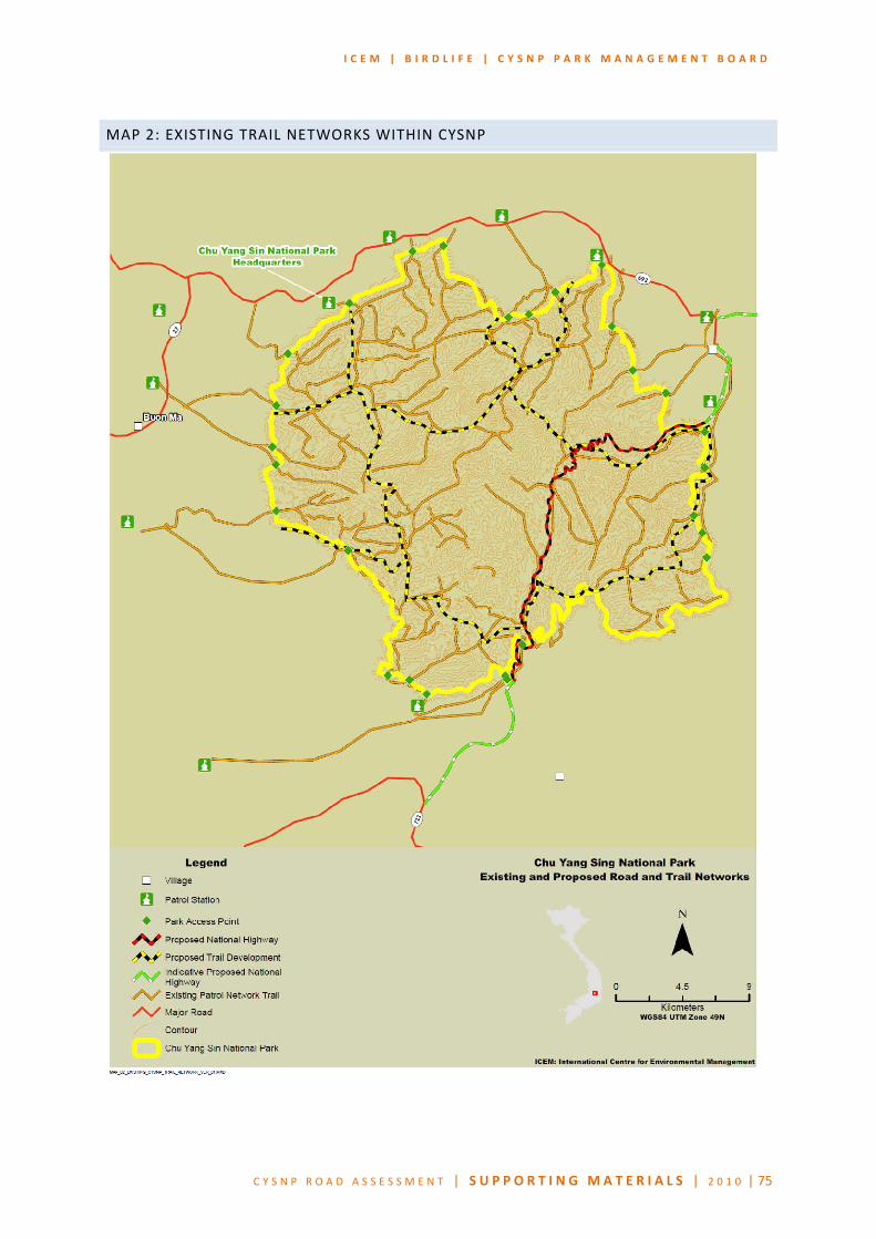
I C E M | B I R D L I F E | C Y S N P P A R K M A N A G E M E N T B O A R D
C Y S N P R O A D A S S E S S M E N T | S U P P O R T I N G MA T E R I A L S | 2 0 1 0 | 75
MAP 2: EXISTING TRAIL NETWORKS WITHIN CYSNP

I C E M | B I R D L I F E | C Y S N P P A R K M A N A G E M E N T B O A R D
C Y S N P R O A D A S S E S S M E N T | S U P P O R T I N G MA T E R I A L S | 2 0 1 0 | 76
MAP 3: SURROUNDING LAND USE AND PROTECTED AREAS OF CYSNP
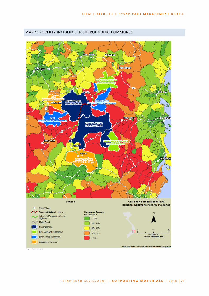
I C E M | B I R D L I F E | C Y S N P P A R K M A N A G E M E N T B O A R D
C Y S N P R O A D A S S E S S M E N T | S U P P O R T I N G MA T E R I A L S | 2 0 1 0 | 77
MAP 4: POVERTY INCIDENCE IN SURROUNDING COMMUNES

I C E M | B I R D L I F E | C Y S N P P A R K M A N A G E M E N T B O A R D
C Y S N P R O A D A S S E S S M E N T | S U P P O R T I N G MA T E R I A L S | 2 0 1 0 | 78
MAP 5: NATIONAL PROTECTED AREASOF VIETNAM & THE SIGNIFICANCE OF CYSNP

I C E M | B I R D L I F E | C Y S N P P A R K M A N A G E M E N T B O A R D
C Y S N P R O A D A S S E S S M E N T | S U P P O R T I N G MA T E R I A L S | 2 0 1 0 | 79
MAP 6: ALTERNATIVE ROUTES FOR THE PROPOSED ROAD DEVELOPMENT
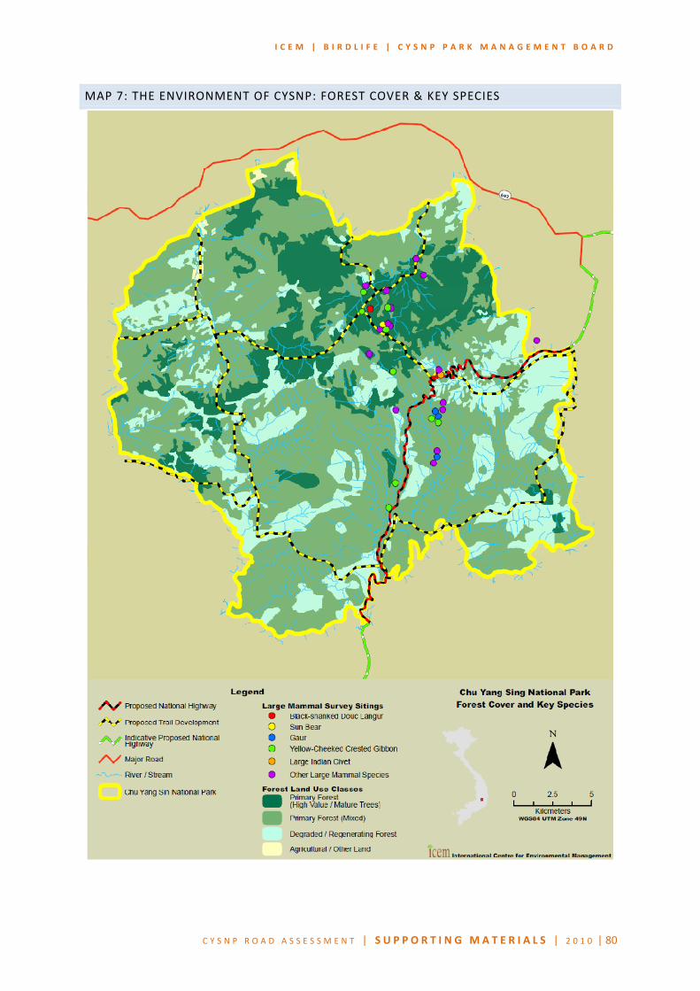
I C E M | B I R D L I F E | C Y S N P P A R K M A N A G E M E N T B O A R D
C Y S N P R O A D A S S E S S M E N T | S U P P O R T I N G MA T E R I A L S | 2 0 1 0 | 80
MAP 7: THE ENVIRONMENT OF CYSNP: FOREST COVER & KEY SPECIES

I C E M | B I R D L I F E | C Y S N P P A R K M A N A G E M E N T B O A R D
C Y S N P R O A D A S S E S S M E N T | S U P P O R T I N G MA T E R I A L S | 2 0 1 0 | 81
MAP 8: CYSNP: ZONE OF INFLUENCE FOR THE PROPOSED ROAD

I C E M | B I R D L I F E | C Y S N P P A R K M A N A G E M E N T B O A R D
C Y S N P R O A D A S S E S S M E N T | S U P P O R T I N G MA T E R I A L S | 2 0 1 0 | 82
MAP 9A: ZONE OF INFLUENCE OF THE PROPOSED TRAIL DEVELOPMENT: 1KM ZOI

I C E M | B I R D L I F E | C Y S N P P A R K M A N A G E M E N T B O A R D
C Y S N P R O A D A S S E S S M E N T | S U P P O R T I N G MA T E R I A L S | 2 0 1 0 | 83
MAP 9B: ZONE OF INFLUENCE OF THE PROPOSED TRAIL DEVELOPMENT: 5KM ZOI