Embed Size (px)
Citation preview

7/28/2019 Carn-y-tyla, Abertywssg
http://slidepdf.com/reader/full/carn-y-tyla-abertywssg 1/25
A.P.A.C. Ltd.
Archaeological Perspectives Analysis Consultancy
ARCHAEOLOGICAL EVALUATION
EV/Asg/13
Land adjacent to Carn-Y-Tyla, Abertysswg(NGR 310640 205754)
Monmouthshire County Council
Outline Planning Application13/0157/OUT
PREPARED BY DR N PHILLIPS
21ST
J UNE 2013
7/28/2019 Carn-y-tyla, Abertywssg
http://slidepdf.com/reader/full/carn-y-tyla-abertywssg 2/25
A.P.A.C. Ltd Land SW of Carn-Y-Tyla Terrace, Abertysswg EV/Asg/12
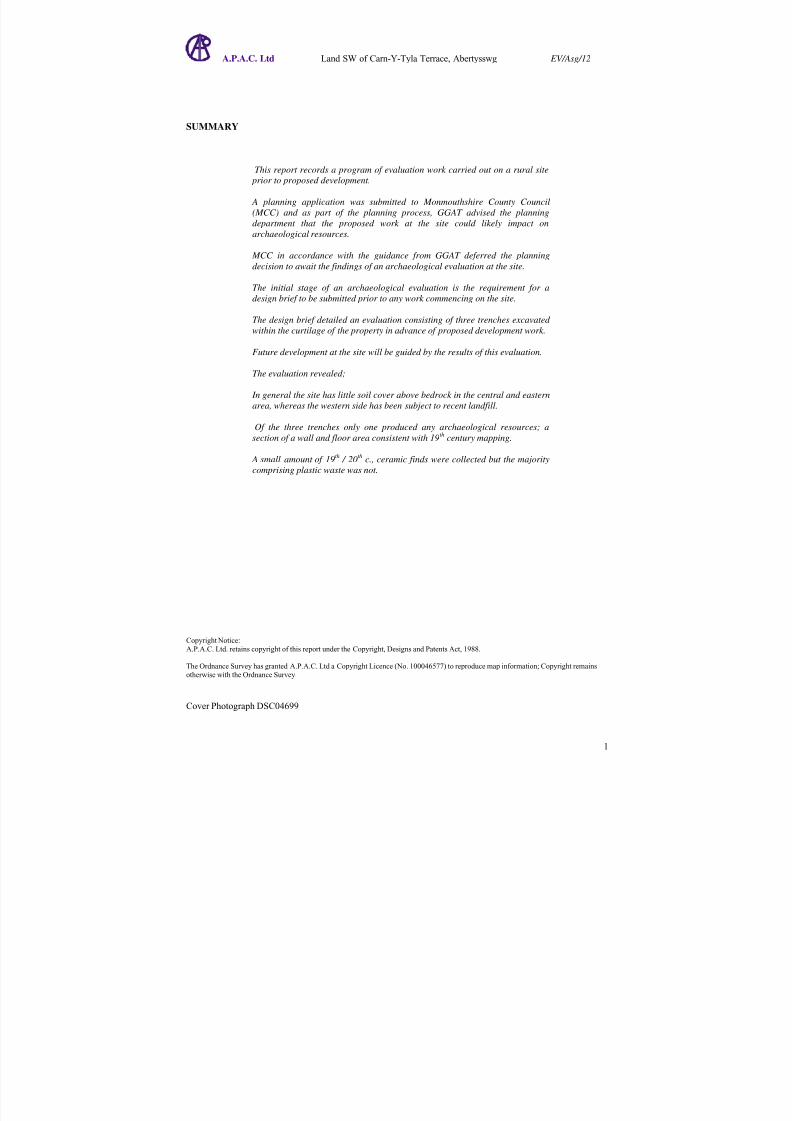
SUMMARY
This report records a program of evaluation work carried out on a rural site
prior to proposed development.
A planning application was submitted to Monmouthshire County Council
(MCC) and as part of the planning process, GGAT advised the planning
department that the proposed work at the site could likely impact on
archaeological resources.
MCC in accordance with the guidance from GGAT deferred the planning
decision to await the findings of an archaeological evaluation at the site.
The initial stage of an archaeological evaluation is the requirement for a
design brief to be submitted prior to any work commencing on the site.
The design brief detailed an evaluation consisting of three trenches excavated
within the curtilage of the property in advance of proposed development work.
Future development at the site will be guided by the results of this evaluation.
The evaluation revealed;
In general the site has little soil cover above bedrock in the central and eastern
area, whereas the western side has been subject to recent landfill.
Of the three trenches only one produced any archaeological resources; a
section of a wall and floor area consistent with 19th
century mapping.
A small amount of 19th
/ 20th
c., ceramic finds were collected but the majority
comprising plastic waste was not.
Copyright Notice:
A.P.A.C. Ltd. retains copyright of this report under the Copyright, Designs and Patents Act, 1988.
The Ordnance Survey has granted A.P.A.C. Ltd a Copyright Licence (No. 100046577) to reproduce map information; Copyright remains
otherwise with the Ordnance Survey.
7/28/2019 Carn-y-tyla, Abertywssg
http://slidepdf.com/reader/full/carn-y-tyla-abertywssg 3/25
A.P.A.C. Ltd Land SW of Carn-Y-Tyla Terrace, Abertysswg EV/Asg/12
C O N T E N T S
Page
1. INTRODUCTION ........................................................... ................................................................ ............. 4
2. LOCATION AND DESCRIPTION OF THE EVALUATION AREAS...................................................... 4
3. BRIEF ARCHAEOLOGICAL AND HISTORICAL BACKGROUND ...................................................... 5
4. RATIONALE OF THE PROJECT............................................................ ................................................... 5
5. AIMS AND OBJECTIVES................................................................. .......................................................... 5
6. SCOPE OF THE WORK............................................................... ............................................................ ... 6
7. METHODOLOGY.................................................................................................................... .................... 6
8. SURVEY......................................................................................................................... .............................. 6
9. DOCUMENTARY RESEARCH.................................................................... .............................................. 7
10. RESULTS............................................................. ................................................................ ........................ 7
11. FINDS SEE APPENDIX II FOR A COMPLETE LIST ........................................................ ........................ 8
12. INTERPRETATION......................................................................................... ............................................ 8
13. CONCLUSIONS............................................................................... ............................................................ 8
14. PREDICTED IMPACTS OF THE PROPOSAL ON KNOWN ARCHAEOLOGY .................................... 9
15. PROPOSED AVOIDANCE OR MITIGATION MEASURES.................................................................... 9
16. ARCHIVE................................................................... .................................................................... .............. 9
17. COPYRIGHT............................................ ................................................................ .................................... 9
18. HEALTH AND SAFETY........................... ................................................................ .................................. 9
19. AKNOWLEDGEMENTS........................................ ..................................................................... ................ 9
20. BIBLIOGRAPHY................................... ................................................................ .................................... 10
7/28/2019 Carn-y-tyla, Abertywssg
http://slidepdf.com/reader/full/carn-y-tyla-abertywssg 4/25
A.P.A.C. Ltd Land SW of Carn-Y-Tyla Terrace, Abertysswg EV/Asg/12
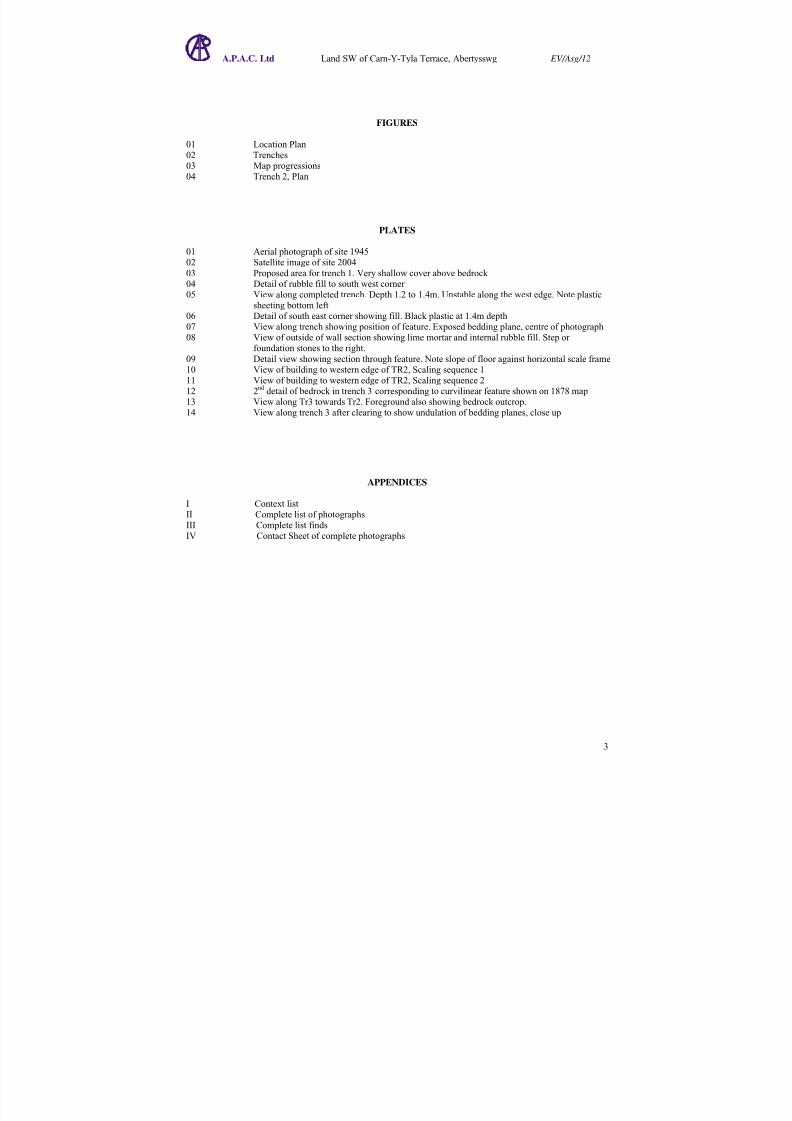
FIGURES
01 Location Plan02 Trenches03 Map progressions04 Trench 2, Plan
PLATES
01 Aerial photograph of site 194502 Satellite image of site 2004
03 Proposed area for trench 1. Very shallow cover above bedrock 04 Detail of rubble fill to south west corner 05 View along completed trench. Depth 1.2 to 1.4m. Unstable along the west edge. Note plastic
sheeting bottom left06 Detail of south east corner showing fill. Black plastic at 1.4m depth07 View along trench showing position of feature. Exposed bedding plane, centre of photograph08 View of outside of wall section showing lime mortar and internal rubble fill. Step or
foundation stones to the right.
09 Detail view showing section through feature. Note slope of floor against horizontal scale frame10 View of building to western edge of TR2, Scaling sequence 111 View of building to western edge of TR2, Scaling sequence 212 2
nd detail of bedrock in trench 3 corresponding to curvilinear feature shown on 1878 map
13 View along Tr3 towards Tr2. Foreground also showing bedrock outcrop.
14 View along trench 3 after clearing to show undulation of bedding planes, close up
APPENDICES
I Context listII Complete list of photographsIII Complete list findsIV Contact Sheet of complete photographs
7/28/2019 Carn-y-tyla, Abertywssg
http://slidepdf.com/reader/full/carn-y-tyla-abertywssg 5/25
A.P.A.C. Ltd Land SW of Carn-Y-Tyla Terrace, Abertysswg EV/Asg/12
1. INTRODUCTION
Dr N Phillips of A.P.A.C. Ltd, was contacted in early June 2013 by the clients MR & Mrs Hudd, in relation to proposed work to be undertaken on land belonging to them; SW of Carn-Y-Tyla, Terrace, Abertysswg.
The proposed development was for the construction three new build, detached dwellings, with parking and access.
The clients; having submitted an outline planning application to Monmouthshire County Council; (pl.app.noDC/13/0157/OUT), were advised that there was a ‘possible archaeological issue for this planning application’therefore ‘the proposal had an archaeological restraint’.
CAE0293/JBHD. May 2013
In the light of this GGAT reminded the planning department at Monmouthshire County Council of PlanningPolicy Wales 4th edition 2011 Section 6.5.1:
The desirability of preserving an ancient monument and its setting is a material
consideration in determining a planning application whether that monument is scheduled or unscheduled.
Where research indicates that important archaeological remains exist, the planning
authority should request the prospective developer to arrange for an archaeological field
evaluation to be carried out before any decision on the planning application is taken.
(ibid).
They advised that determination of the planning application should be deferred until an archaeologicalevaluation had been undertaken at the site.
The client was also advised of this and contacted Dr N Phillips of A.P.A.C. Ltd to undertake the work.
2. LOCATION AND DESCRIPTION OF THE EVALUATION AREAS
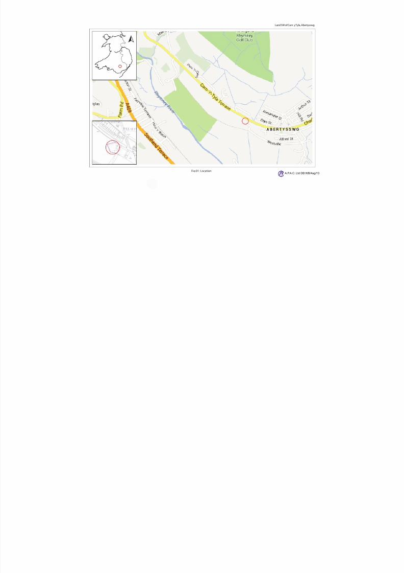
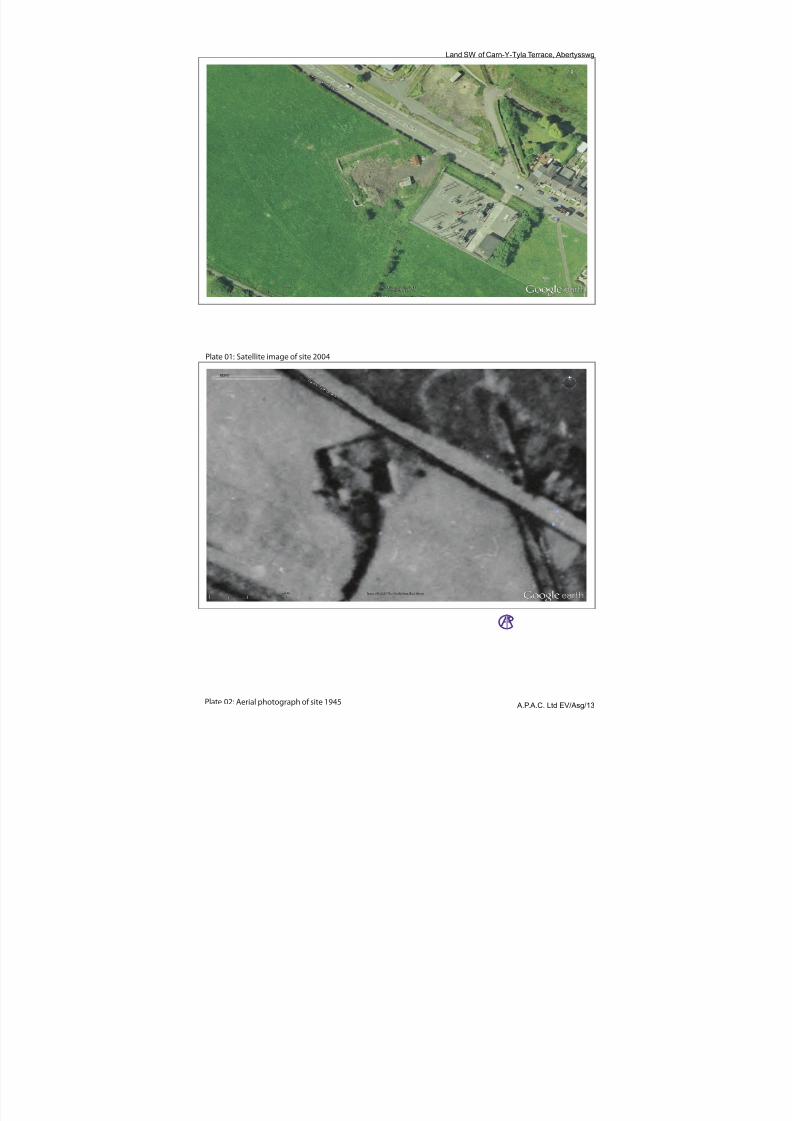
The site lies to the south west of the Carn-Y-Tyla Road, Abertysswg and adjacent to the electricity station. Theexact position is shown in the 2004 satellite image from Google Earth, Plate 01.
The parcel of land to be investigated is enclosed on by a barbed wire fence north east, north west and south westwith open ground to the south. The east is bounded by the security fence of the electricity site.
The ground has a general N/S gradient drop of 1:10.4, fig 02. To the north is a 0.9m embankment which rises at1:2.9 whilst in the south west corner the slope swings west, increasing to a gradient of 1:6.
The position of the site to the road is of interest in that it is the only feature that is out of alignment and thereforeindicative of its earlier layout. Plate 02, a 1945 aerial photograph emphasises the point showing the site prior to
the development of housing across the road.
The 2004 satellite image shows that the site was undergoing disturbance at the time, which, according to theclient, resulted from deposition of material from adjacent building works, ( pers comm. Mr Hudd).
The results of this deposition were still evident at the time of the evaluation especially around the western and
northern edges where there were banks of rubble stone.
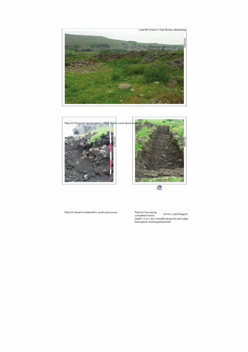
Two main areas of clearly defined standing wall were evident:
At the north west corner was a stretch of well shaped blocks making a drystone wall, Plate 03. At the south west corner were the remains of a mortared corner wall. Plate 04.
Th l l ll d fi d t f d t ll th t d th id hi h l t t th
7/28/2019 Carn-y-tyla, Abertywssg
http://slidepdf.com/reader/full/carn-y-tyla-abertywssg 6/25
A.P.A.C. Ltd Land SW of Carn-Y-Tyla Terrace, Abertysswg EV/Asg/12
evidence remained.
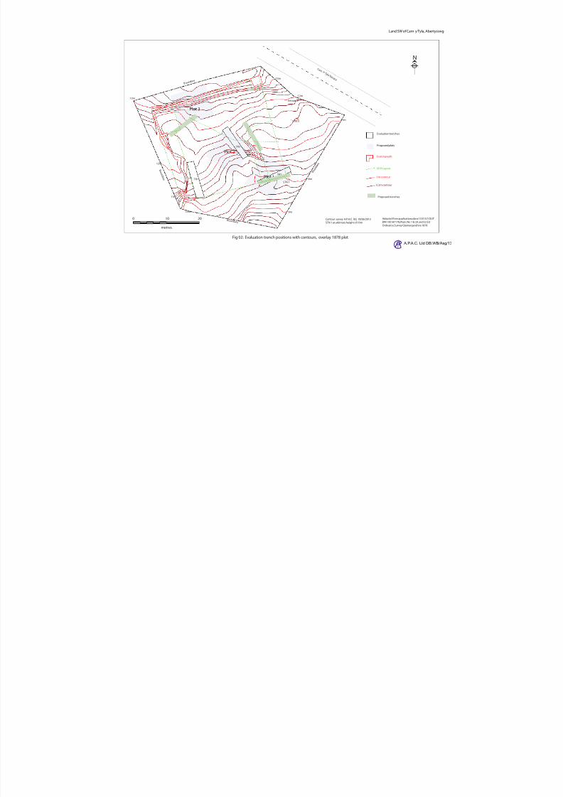
The field evaluation consisted of three trenches 10m x 2m, as shown in fig 02. The trenches differ from those proposed in design brief as can be seen in the diagram.
The reason for the re-alignment was the nature of the ground in the areas proposed:
The original trench 1 to the north west, was in an area with a great deal of loose stone over very shallow soilwith exposed bedrock. Trench 1 was repositioned to the south west of the site to evaluate the edge of the existingwall and the 1878, Ordnance Survey wall position Fig 03.
Trench 2 remained in approximately the same position, again to evaluate structures recorded on the 1878,Ordnance Survey Map.
Trench 3 was positioned around 3 m to the left of the proposed position. This time the reason was due to a lack of any appreciable soil in the area. Possibly a result of levelling carried out with the 2004 work mentioned above.
3. BRIEF ARCHAEOLOGICAL AND HISTORICAL BACKGROUND
The Rhymney Valley in which the site lies was very sparsely populated up until the early 19 th century when the
coal and iron industries of the industrial times changed dramatically the South Wales region. Such changesincluded the rail and road links between coal mines and ports; housing and works buildings for the variousindustries.
The closest village, Abertysswg, probably arose in the last decade of the 19th century to service the MclarenColliery, Abertyswwg, the first shaft of which was sunk in 1895, (www.welshcoalmines.co.uk/).
There is a paucity of known archaeological resources in the immediate area of the site.
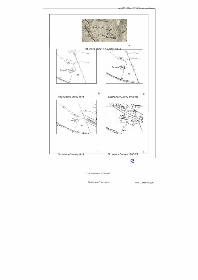
The first record of the site, as noted by GGAT, CAE0293/JBHD is an isolated rectangular enclosure called Carn-
Y-Telorau, fig 03a. It has to be said however that it is difficult to establish that this is the same site with anydegree of certainty.
The 1878 Ordnance Survey Map 1:25000, Fig 03b, is much more definitive and shows a rectangular enclosed
area, Carn-tyle, containing a series of internal divisions, probable buildings, on the east and west and acurvilinear, north east division. The buildings would appear to be similar to those still standing in 1945, Plate 02.Also shown is a railway to the south and a path leading from the south east corner of the site to a roadway to thenorth.
The general layout of the area has not changed by the 2nd
edition map of 1900-01, fig 03c, other than theinclusion of detail division of the noted buildings and a change to the roadway junction.
The following 18 years saw the present road being built close to the site and the former roadway abandoned. The
1919 map, fig 03d also shows that some of the internal structures along the west side had been removed.
With the exception of the building of the adjacent electricity station to the east, there was no further change tothe site up to 1973 fig 03e.
As was noted above, Plate 01, the buildings had been removed by 2004, replaced by two small sheds.
4. RATIONALE OF THE PROJECT
The proposed development is within an enclosed area recorded on 1878 ordnance survey mapping, and possiblyearlier 1833 mapping, as having the same footprint as the current site. The enclosed area is recorded as having
had internal structures and therefore possible archaeological resources; which if present, may be impacted upon by any development.
7/28/2019 Carn-y-tyla, Abertywssg
http://slidepdf.com/reader/full/carn-y-tyla-abertywssg 7/25
A.P.A.C. Ltd Land SW of Carn-Y-Tyla Terrace, Abertysswg EV/Asg/12
Elucidate the character, distribution, extent and importance of any potential archaeological remains, extant in thedevelopment area; allowing for the production of a sufficiently detailed report to be used to inform and mitigateany associated development.
This was to be realized through the following objectives:
A program of evaluation trenching, undertaken specifically to establish the presence and extent of
significant archaeological deposits, features and structures.
An evaluation report providing sufficiently detailed information to allow informed decisions tosafeguard the archaeological resource, taken on the basis of its contents.
This report has been produced from the results of the evaluation and contains a detailed summary of themethodology, site history, deposits/features/ structures/artefacts uncovered and interpretation of the results.
6. SCOPE OF THE WORK
The archaeology of the application site as a whole, in its wider local or regional context, was considered,although the evaluation was confined to those areas which were directly affected by the development or someaspect of it. All remains of potential interest were considered, whatever their date.
7. METHODOLOGY
A trenching strategy was drawn up with reference early Ordnance Survey Mapping and preliminary discussionwith Judith Doyle GGAT.
Three trenches, 10m x 2m, were excavated within the designated parcel of land; fig 02.
Trenches 2 & 3 were excavated to the archaeological horizon or natural by mechanical digger and then cleared
manually.
Trench 1 was excavated to a depth of 1.4m into a deposition fill of loose modern rubble and landfill. The natureof the fill made the trench edges unstable and for health and safety reasons it was abandoned.
The evaluation trenching allowed for the character, distribution, extent and importance of at least the minimum
number of archaeological features to be understood.
A topographical survey was undertaken of the trenches to locate them within the boundary of the propertythereby allowing for any future work.
Sufficient documentary research was undertaken to place the results of the evaluation in their historic context.
Assessment and analysis of all data collected or compiled was undertaken and the results thereof compiled intoreport form.
A complete archive of the work undertaken will be deposited with Gwent Record Office, with the originaldocumentary archive kept with A.P.A.C.
8. SURVEY
Survey was undertaken at the end of the evaluation trenching with the important features recorded using aTopcon GPT 3007 REDM, Reflectorless Electronic Distance Measurement, Total Station.
Surveyed data was processed in Civilcad 6 and corrected to plans available with the planning application.
Fi l i d t th d f th k ith ll d t b i t f d i t A t d f l tti d
7/28/2019 Carn-y-tyla, Abertywssg
http://slidepdf.com/reader/full/carn-y-tyla-abertywssg 8/25
A.P.A.C. Ltd Land SW of Carn-Y-Tyla Terrace, Abertysswg EV/Asg/12
9. DOCUMENTARY RESEARCH
Research undertaken to complete the background history of the site was completed from the following sources:
A.P.A.C. Ltd Library. Archaeological Data Service. (http://archaeologydataservice.ac.uk/) Current site data from the landowner Glamorgan Gwent Historic Environment Record (http://www.archwilio.org.uk/) Royal Commission on the Ancient and Historical Monuments Wales (http://www.coflein.gov.uk/). Gwent Record Office, Ebbw Vale Google Earth www.visionofbritain.org.uk www.Old-maps.co.uk
10. RESULTS
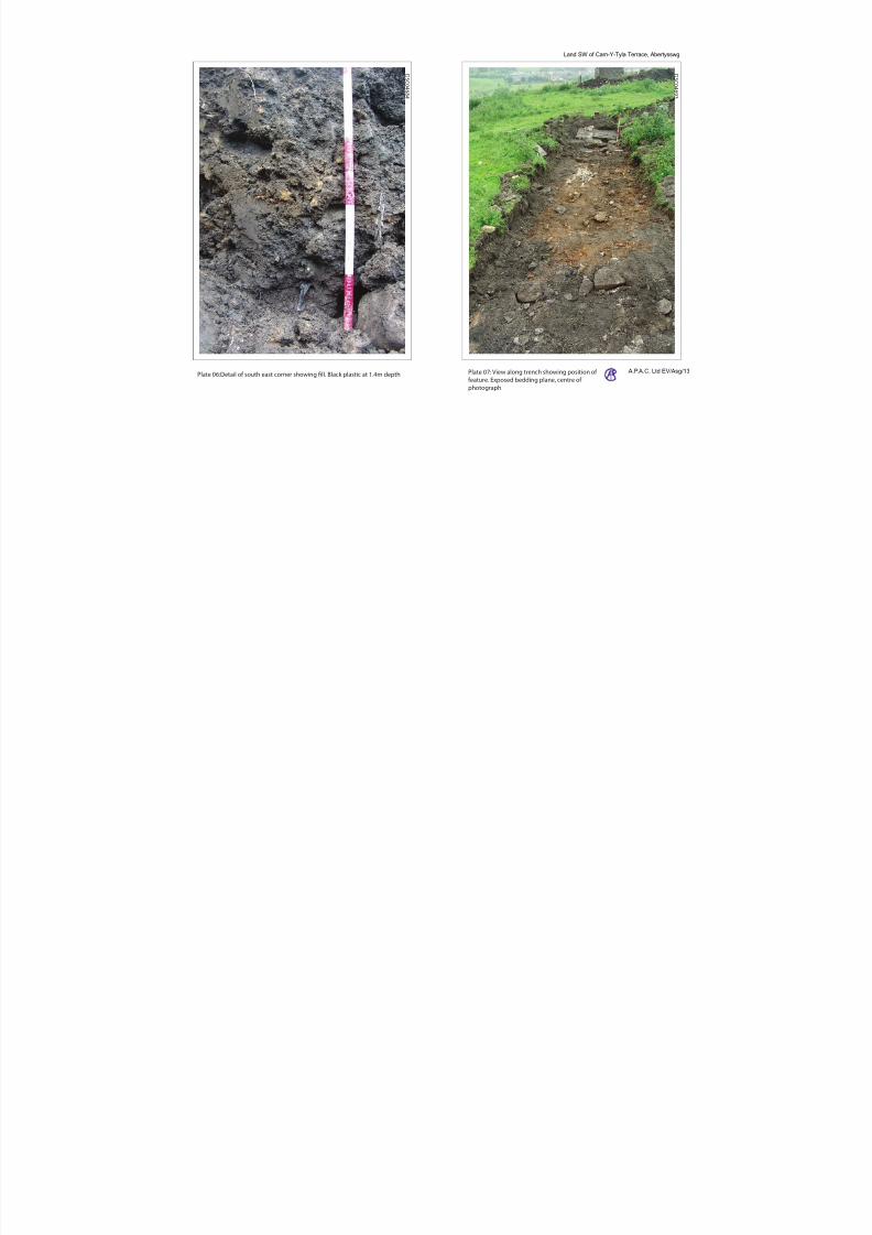
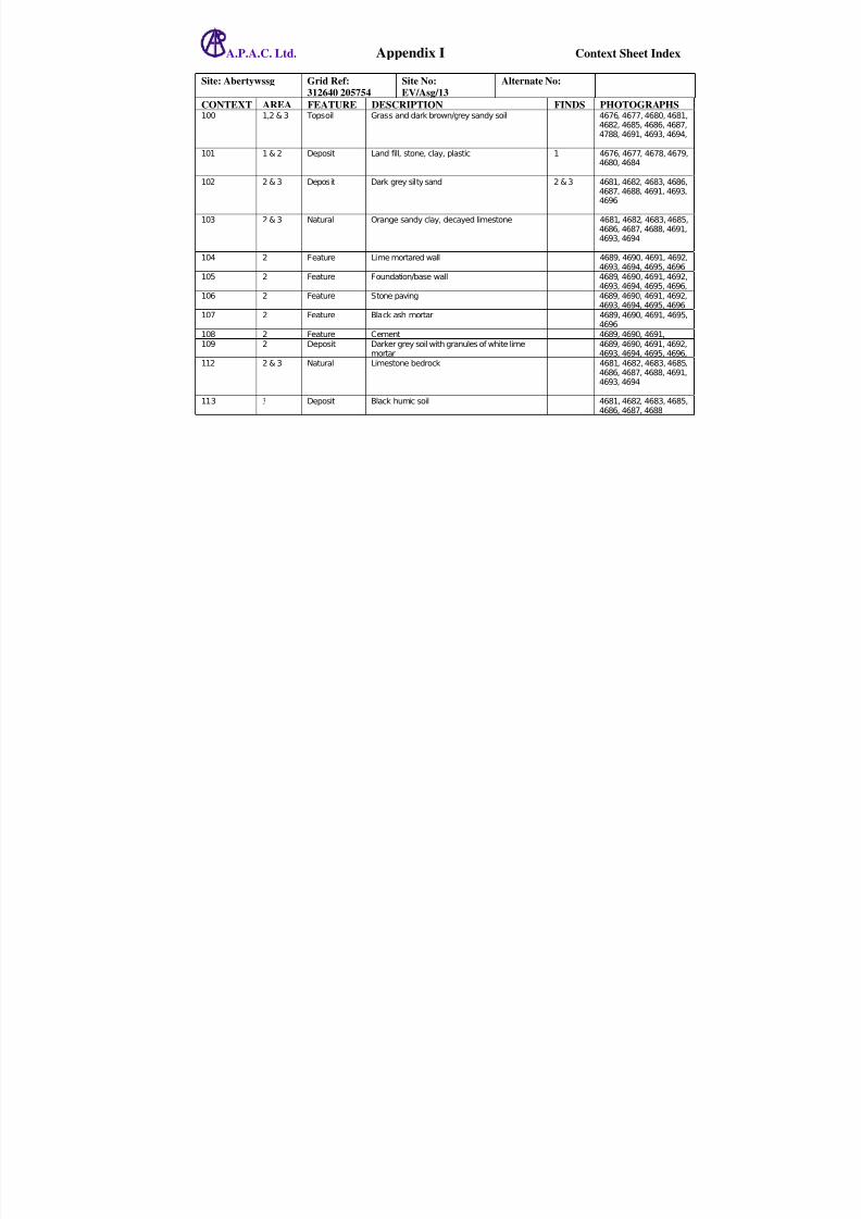
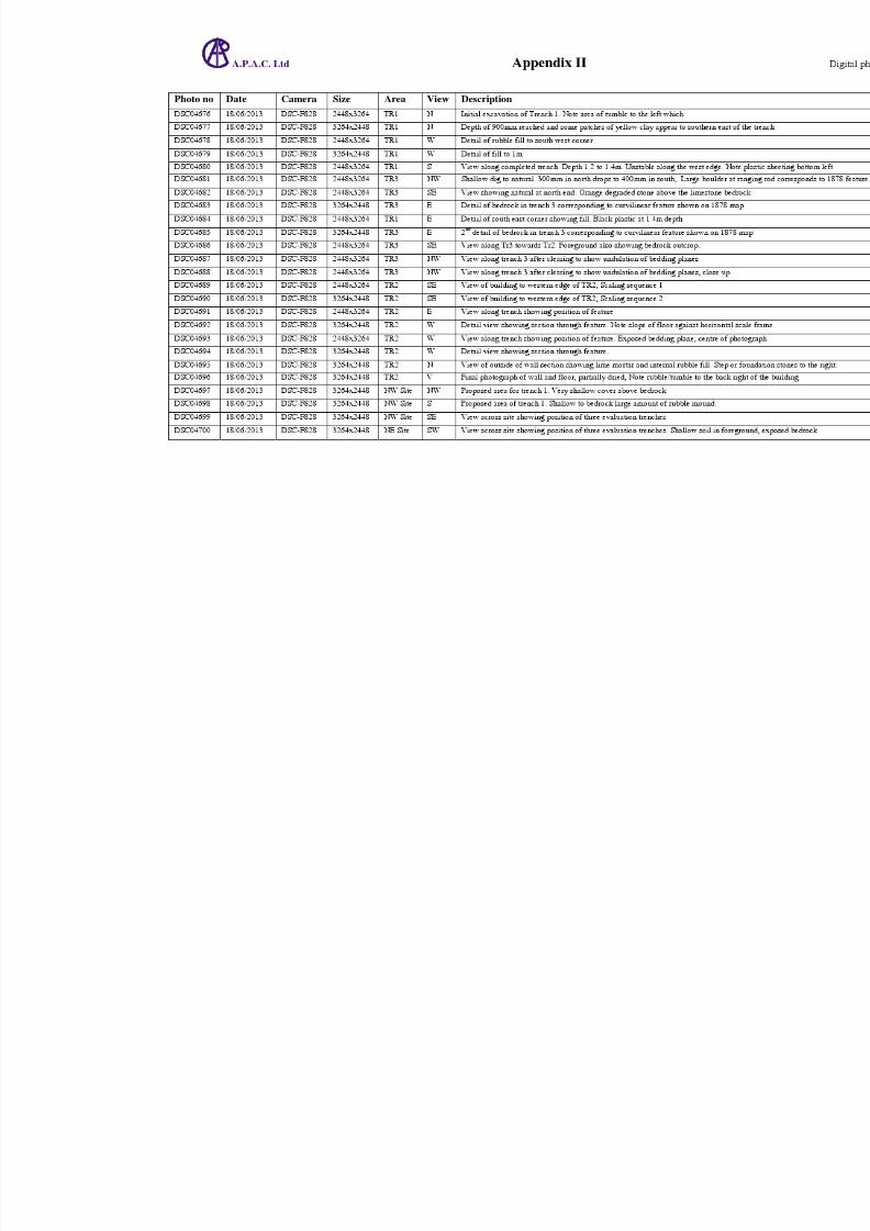
Trench 1 (refer to fig 02 for location) (Brackets [ ] denote context number)
Trench 1 was excavated to a depth of 1.4m at which point the instability of the ground made it unsafe tocontinue. Plate 04 shows some detail of the ground into which the trench was excavated with Plate 05 showing
the full trench at 1m depth.
A further example of the abandoned trench is shown in Plate 06 at a depth of 1.4m in the south east corner:
barbed wire top left, black plastic centre right and bottom, small clumps/spreads of yellow clay
The simple sequence of the trench was from the top a layer a cover of grass, context [100] over landfill rubblecontext [101].
The majority of finds from the trench consisted of plastic bags, bottles and yogurt containers which were not
retained. Finds retained {1} were late 19th/20th century glass and ceramics see appendix III.
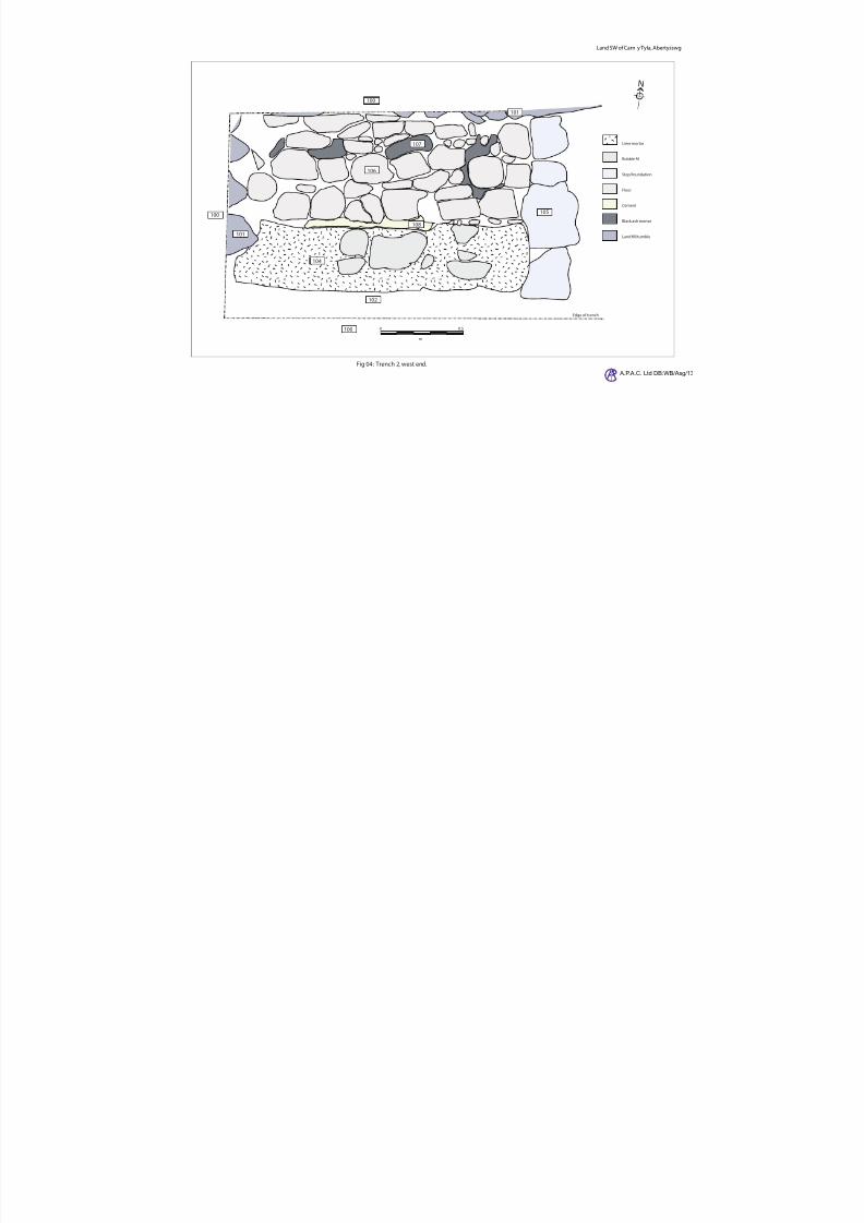
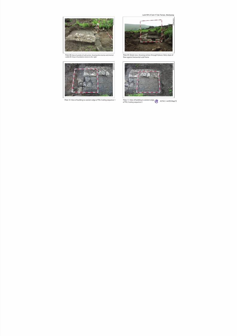
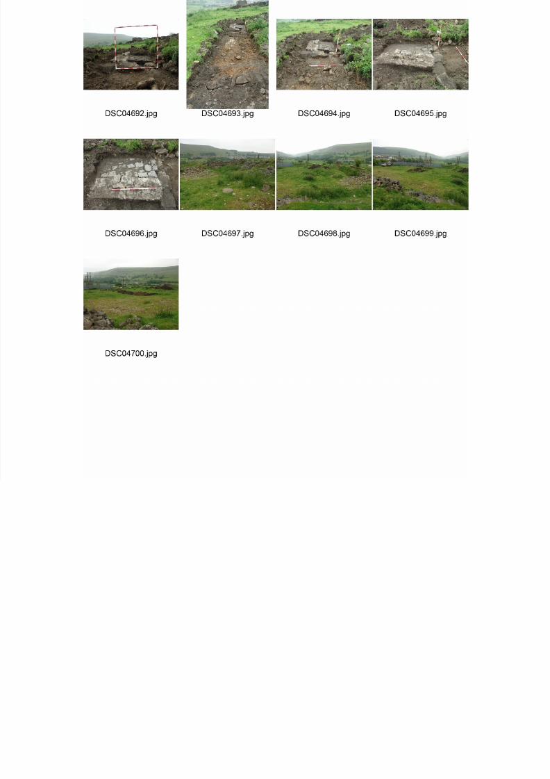
Trench 2 (refer to fig 02 for location and fig 04 for section detail)(Brackets [ ] denote context number)
Trench 2 was excavated to natural for the majority of its length as can be seen in Plate 07; however, the westernend of the trench dominated by the remains of a mortared wall and area of internal flooring.
The general sequence of the trench was from the top, context [100] under which was dark grey silty sand,context [102] to a depth of 150mm. This overlay a thin deposit of orange sandy clay, context [103] before thelimestone bedrock [112].
At the western end, the sequence ran [100] over [102] with an isolated patch of [101] some 1.9m from the end of the trench and visible top right; between the ranging rods, Plate 08.
The feature itself compromises:
The end of a lime mortared wall exposed for 1.7m but extending west beyond the limit of the trench
[104]. A foundation or base course of large stone extending north beyond the limit of the trench [105]. An area of flooring made up of flat stone [106] and bonded with black ash mortar [107] and partially
edged with cement [108], fig 04.
7/28/2019 Carn-y-tyla, Abertywssg
http://slidepdf.com/reader/full/carn-y-tyla-abertywssg 9/25
A.P.A.C. Ltd Land SW of Carn-Y-Tyla Terrace, Abertysswg EV/Asg/12
The depth of the excavation can be seen in Plate 09 with the top of [104] at less than 10mm from the surface,[105] at 300mm and the limit of the trench; to the left of [105], at 500mm.
Detail photographs of the wall and floor can be seen in Plates 10 & 11.
Finds from trench two included a quantity of rough dressed building stone which were not retained. Retained finds amounted to some shards of glass and a decimal two pence piece {2}.
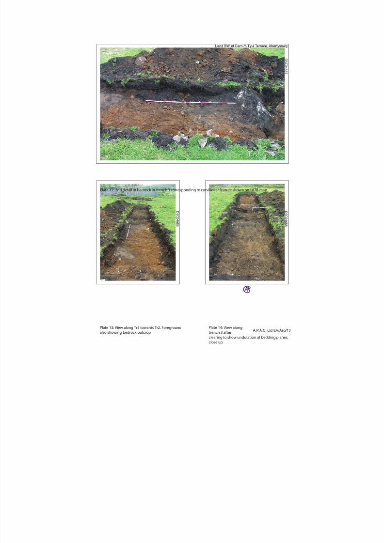
Trench 3 (refer to fig 02 for location and fig 05 for section detail)(Brackets [ ] denote context number)
(Brackets [ ] denote context number, complete lists in Appendix Ia)
Trench 3 was excavated to natural, the depth of which differed at each end of the trench: changing dramatically
around 4m from the northern end, Plate 12.
The sequence in the northern half was context [113], a very humic, black soil, over [102] and then [112]. Theaverage depth of [112] being <200mm.
Plate 13 shows the position of the limestone outcrop shown in Plate 12 at which the depth of natural increases.
Viewed from the opposite end of the trench, Plate 14 shows the drop in level, just behind the ranging rod.
The deposition sequence also changes to the south of the drop point with [102] previously identified in Trench 2,overlaying [113].
Finds retained from trench 3 {3} were 5 sherds of ceramic and one shard of glass, late 19th/20
th
11. FINDS see appendix ii for a complete list
{1} Trench 1 [101] 19th 20th c, domestic ware and consumer packaging{2} Trench 1 [102] 19
th20
thc, domestic ware
{3} Trench 1 [102] 19th 20th c, domestic ware
12. INTERPRETATION
The findings from trench 1 were inconclusive as neither an archaeological resource nor a natural horizon wasfound. The depth of the trench does tend to suggest that any features that may have existed in this area are likely
to have been destroyed especially given the proximity of the existing wall assumed to be part of the anticipated structure.
Trench 2 has shown that in this area at least some archaeological resources relating to the features marked on theOrdnance Survey Mapping do remain in situ.
Trench 3 was partially successful in that it identified a feature marked on the 1878 map and noted above as a‘curvilinear north east division’. It would appear that this feature is a natural occurrence; however, that does not
discount the possibility that its presence was not utilised. The difference in deposition sequence with the additionof the humic soil suggests that this had been a separated plot, possibly a garden or an animal enclosure.
13. CONCLUSIONS
In general, information derived from this evaluation would tend to suggest that central and eastern part of thesite has been stripped of its soil cover, possibly during the work carried out around 2004. Therefore, any remains
would be limited to foundation trenches in the bedrock which would be unlikely.
However, this does not hold true for the south eastern half were there are archaeological resources present.
The western half of the site has been filled with a large quantity of loose rubble to at least a depth of 1.4m.
i h i f h di ll l h i i lik l h i ill b b l

7/28/2019 Carn-y-tyla, Abertywssg
http://slidepdf.com/reader/full/carn-y-tyla-abertywssg 10/25
A.P.A.C. Ltd Land SW of Carn-Y-Tyla Terrace, Abertysswg EV/Asg/12
14. PREDICTED IMPACTS OF THE PROPOSAL ON KNOWN ARCHAEOLOGY
The proposed development will impact upon known archaeological resources in the areas of plot 1 and plot 3,
the latter being an existing drystone wall.
However, there is no reason arising from this evaluation to suggest that the archaeological resource has any
major significance.
15. PROPOSED AVOIDANCE OR MITIGATION MEASURES
It would be advisable to conduct a watching brief during any further ground disturbance.
16. ARCHIVE
The project archive will consist of all original records, and all documentation that relates to the evaluation.
Copies of the Design Brief and any relevant correspondence will be included.
The original archive will be retained by A.P.A.C. ltd with a secondary copy deposited with Gwent Record office.
The Archaeological Contractor will return all artefacts, ecofacts/samples to the client, their legal owner.
The archive will be prepared according to the Management of Archaeological Projects, English Heritage,Second Edition, (1991) so the records will be fully ordered and indexed.
The archive will be deposited within twelve months of the completion of the evaluation and with the agreementof the landowner.
A copy of the report will be lodged digitally with the Historic Environment Record, Scribd and the ADS.
A synopsis of the project will be submitted to CBA Wales.
17. COPYRIGHT
A.P.A.C. Ltd will retain full copyright of any reports and specialist reports, under the Copyright, Designs and Patents Act of 1988 with all rights reserved. A.P.A.C. Ltd hereby gives permission for the monitoring authority
to use any documentation directly relating to the project as described in the Project Design PD/EV/Asg/13following a period of 12 months after the evaluation is completed.
18. HEALTH AND SAFETY
The Project Team operated in accordance with the health and safety procedures as set out in:-
The Health and Safety Work Act (1974) and related legislation.
The Standing Conference of Archaeology Unit Managers Health and Safety Manual 2002).
The Council for British Archaeology Handbook no. 6, Safety in Archaeological Fieldwork (1989).
All necessary protective clothing and equipment was used.
19. AKNOWLEDGEMENTS
I would like to a thank Mr & Mrs Hudd & son for their assistance.
7/28/2019 Carn-y-tyla, Abertywssg
http://slidepdf.com/reader/full/carn-y-tyla-abertywssg 11/25
7/28/2019 Carn-y-tyla, Abertywssg
http://slidepdf.com/reader/full/carn-y-tyla-abertywssg 12/25
Fig 01: Location
A.P.A.C. Ltd DB:WB/Asg/1
Land SW of Carn y Tyla, Abertysswg
7/28/2019 Carn-y-tyla, Abertywssg
http://slidepdf.com/reader/full/carn-y-tyla-abertywssg 13/25
N
A.P.A.C. Ltd DB:WB/A
Land SW of Carn y Tyla, Abertyssw
Adapted from application plans 13/0157/OUT
BW1 00147178,Plans No 1 & 2A and Ist Ed
Ordnance Survey Glamorganshire 1878
Fig 02: Evaluation trench positions with contours, overlay 1878 plot
Contour survey A.P.A.C. ltd, 18/06/2013.
STN 1 at arbitrary height of 10m.
STN 1
STN 3
Plot 2
Plot 1
Plot 3
0 10 20
metres
B o u n d a r y
B o u n d ar y
B o u n
d a r y
B o u n d a r y
Entrance
way
Existing walls
Proposed plots
Evaluation trenches
1878 Layout
TR1
TR2
TR3
C a r n - Y - T y l a T e r r a c e
9m
10m
10m
11m
11m
12m
12m
13m
13m
Proposed trenches
1m contour
0.2m contour
7/28/2019 Carn-y-tyla, Abertywssg
http://slidepdf.com/reader/full/carn-y-tyla-abertywssg 14/25
Land SW of Carn-Y-Tyla Terrace, Abertywssg
OS Li 100046577
1st series, sheet 42 (Colby ) 1833
Ordnance Survey 1878 Ordnance Survey 1900-01
Ordnance Survey 1919 Ordnance Survey 1960-73
a
b c
d e
7/28/2019 Carn-y-tyla, Abertywssg
http://slidepdf.com/reader/full/carn-y-tyla-abertywssg 15/25
N
Lime mortar
Rubble ll
Step/foundation
Floor
Cement
Black ash mortar
Land ll/tumble
A.P.A.C. Ltd DB:WB/A
Land SW of Carn y Tyla, Abertyssw
Fig 04: Trench 2, west end.
0 0.5
m
Edge of trench
101
101
102
104
105
106
107
108
100
100
100
7/28/2019 Carn-y-tyla, Abertywssg
http://slidepdf.com/reader/full/carn-y-tyla-abertywssg 16/25
Plate 01: Satellite image of site 2004
Land SW of Carn-Y-Tyla Terrace, Abertysswg
7/28/2019 Carn-y-tyla, Abertywssg
http://slidepdf.com/reader/full/carn-y-tyla-abertywssg 17/25
7/28/2019 Carn-y-tyla, Abertywssg
http://slidepdf.com/reader/full/carn-y-tyla-abertywssg 18/25
D S C 0 4 6 9 3
D S C 0 4 6 8 4
Plate 07: View along trench showing position of
feature. Exposed bedding plane, centre of
photograph
Plate 06:Detail of south east corner showing ll. Black plastic at 1.4m depth A.P.A.C. Ltd EV/Asg/1
Land SW of Carn-Y-Tyla Terrace, Abertysswg
7/28/2019 Carn-y-tyla, Abertywssg
http://slidepdf.com/reader/full/carn-y-tyla-abertywssg 19/25
Plate 10: View of building to western edge of TR2, Scaling sequence 1 Plate 11: View of building to western edge
of TR2, Scaling sequence 2
Plate 08: View of outside of wall section showing lime mortar and internal
rubble fill. Step or foundation stones to the right
Plate 09: Detail view showing section through feature. Note slope of
oor against horizontal scale frame
D S C 0 4 6 9 2
D S C 0 4 6 9 5
D S C 0 4 6 9 0
D S C 0 4 6 8 9
A.P.A.C. Ltd EV/Asg/13
Land SW of Carn-Y-Tyla Terrace, Abertysswg
7/28/2019 Carn-y-tyla, Abertywssg
http://slidepdf.com/reader/full/carn-y-tyla-abertywssg 20/25
D S C
0 4 6 8 5
D S C 0 4 6 8 8
D S C 0 4 6 8 6
Plate 14: View along
trench 3 after
l i t h d l ti f b ddi l
Plate 13: View along Tr3 towards Tr2. Foreground
also showing bedrock outcrop.
Plate 12: 2nd detail of bedrock in trench 3 corresponding to curvilinear feature shown on 1878 map
A.P.A.C. Ltd EV/Asg/13
Land SW of Carn-Y-Tyla Terrace, Abertysswg
7/28/2019 Carn-y-tyla, Abertywssg
http://slidepdf.com/reader/full/carn-y-tyla-abertywssg 21/25
7/28/2019 Carn-y-tyla, Abertywssg
http://slidepdf.com/reader/full/carn-y-tyla-abertywssg 22/25

7/28/2019 Carn-y-tyla, Abertywssg
http://slidepdf.com/reader/full/carn-y-tyla-abertywssg 23/25
A.P.A.C. Ltd. Appendix III Finds Index
Site: Abertywssg Grid Ref:
312640 205754
Site No: EV/Asg/13 Alternate No:
Find No AREA Context DESCRIPTION Period Date1 TR1 101 2 sherds stoneware
1 shard clear glass1 sherd blue & white china3 sherds white china
1 sherd glazed patterned ceramic2 sherds glazed earthen ware2 sherds unglazed earthen ware
19th
– 20th
20th
19th
– 20th
19th
– 20th
19th – 20th 19
th– 20
th
19th
– 20th
18/06/2012
2 TR2 102 1 shard amber glass. Bottle base1 shard clear glass. Bottle base5 sherds of clear glass1 1975 two pence piece
20th
20th
20th
20th
18/06/2012 3 TR3 102 3 sherds ridged marmalade pot. stoneware
1 shard aqua glass bottle base embossed2 sherds of white ceramic
19th
– 20th
19th
– 20th
19th
– 20th
18/06/2012
7/28/2019 Carn-y-tyla, Abertywssg
http://slidepdf.com/reader/full/carn-y-tyla-abertywssg 24/25
7/28/2019 Carn-y-tyla, Abertywssg
http://slidepdf.com/reader/full/carn-y-tyla-abertywssg 25/25