Embed Size (px)
Citation preview
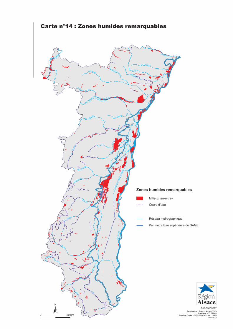
Carte n°14 : Zones humides remarquables
0 20 km
N
SIG-ENV-3317
Réalisation : Région Alsace / SIGDonnées : CG 67&68
Fond de Carte : ©IGN BD Carto (éd. 1996)Mai 2013
Milieux terrestres
Réseau hydrographique
Cours d'eau
Zones humides remarquables
Lauter
Nord L'Eberbach
Sauer
Seltzbach
Mossig
Zorn
L'And
lauB
ruch
e
Souffel
Zinzel du
Weiss
Lièpvrette
Giessen
Moder
Fecht
Thur
Largue
Doller
La
L'Ill
La
La
Le
La
La
La
La
La La
La
La
LaLa
Le
La
La Sar
re
SudZinzel du
La
Le C
anal d
u R
hône a
u R
hin
L'Ill
LE
RH
IN
RH
IN
LE
Le
de Marne au Rhin
la
canal
L'E
hn
Lauter
Nord L'Eberbach
Sauer
Seltzbach
Mossig
Zorn
L'And
lauB
ruch
e
Souffel
Zinzel du
Weiss
Lièpvrette
Giessen
L'E
hn
Moder
Fecht
Thur
Largue
Doller
La
L'Ill
La
La
Le
La
La
La
La
La La
La
La
LaLa
Le
La
La Sar
re
SudZinzel du
La
Le C
anal d
u R
hône a
u R
hin
L'Ill
LE
RH
IN
RH
IN
LE
Le
de Marne au Rhin
la
canal
Périmètre Eau supérieure du SAGE
SCHWEIZ
BADEN-
WÜRTTEMBERG
0 2010
Km
±SIG-ENV-3321
Réalisation : Région Alsace / SIGSDonnées : Région Alsace
Fond de carte : Région Alsace
Mai 2013
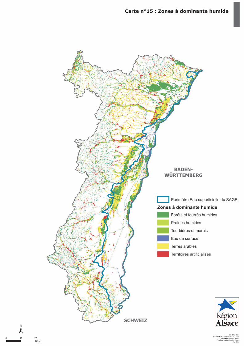
Carte n°15 : Zones à dominante humide
Perimètre Eau superficielle du SAGE
Zones à dominante humide
Forêts et fourrés humides
Prairies humides
Tourbières et marais
Eau de surface
Terres arables
Territoires artificialisés
"
"
"
"
"
"
"
"
Colmar
Obernai
Mulhouse
Sélestat
Haguenau
Strasbourg
Saint-Louis
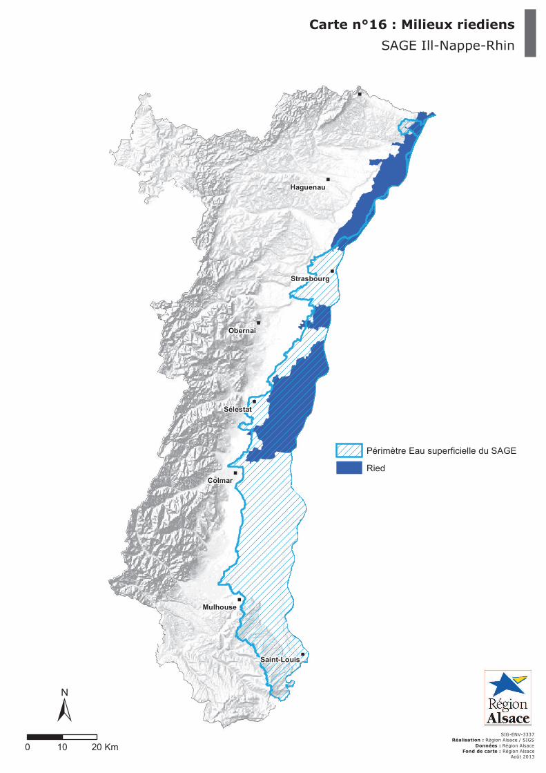
Carte n°16 : Milieux riediens
SIG-ENV-3337Réalisation : Région Alsace / SIGS
Données : Région AlsaceFond de carte : Région Alsace
Août 2013
0 10 20 Km
±
Périmètre Eau superficielle du SAGE
Ried
SAGE Ill-Nappe-Rhin
������������ �������������� �������� ������� �������������� ����
�
������������ ������������ �������� ������� �������������� ����
�
!
!!
!!
!
!!!!
!!!!!!
!!!!!!
!!
!!!!!
!!!
!!!
!!
!
!
!!!
!!
!
!
!
!
!
!!
!!
!!
!
!!!!
!!!!!
!!!!!!
!!
!
!
!!
!
!!!
!!
!
!!!!!
!
!
!!
!
!
!
!!
!
!
!
!
!
!
!!!!!!!!
!!!
!!!!!
!
!!!
!!
!!
!
!
!!!
!!!
!
!!
!!!
!!
!!!
!!!
!
!
!
!
!!
!
!!
!
!!!
!!!!!! !
!
!!!!!
!
!!!!!
!
!
!!!!!!!!!
!!!!!
!!
!!!!!
!!!
!!!!
!!
!!!
!!!
!
!!!!!!
!!
!!!!!
!!!!!!
!!
!
!
!
!!!
!
!
!
!!!
!
!!
!!
!
!!!
!! !
!
!
!
!
!
!!!
!!!!!
!
!!
!
!
!!!!!!!!!
!
!!!!!!!!!!
!!! !
!
!
!!!
!!!!!!
!
!
!!
!!!
!!
!
!!
!
!!
!!!!
!
!!
!!
!!!!!!!
!!!!!!
!
!!!!!!
!!!
!!!!!
!!!!
!
!
!!
!!!
!
!!
!!!
!!
!
!!!!!
!!!!!!
!
!
!!!!
! !
!
!
!!
!!
!
!!!!!!
!!! !!!!
!!
!!!!!
!!!!!
!
! !!
!! !
!
!!!!!!!!!!!
!
!
!
!
!!
!!!!!!!!!!
!
!!!!!!! !
!!!!
!
!!!
!
!!!
!!!
!
!!
!!!
!!!!
!!!!!!
!
!!!
!!!
!
!
!
!
!!!!!
!
!
!!!
!
!
!!!
!!!! !!!!
!!
!!!!! !!
!!!!
!!!!!!!!
!
!!!!!!!!
!
!!!
!
!
!!!!!
!!!!!!!!!!!
!! !!
!
!
!!
! !
!!!!
!!
!
!!!
!
!!!!!
!!!
!!!!
!! !!!
! !!!
!
!!
!!
!
!
!
!
!!
!
!
!!
!!!!!!!!!
!
!!!
!
!
!
!
!!
!
!!!!!!!!!
!
!!
!!!
!!!
!
!
!
!!
!
!!!
!
!
!
!!!!!!!!!
!!
!
!!!
!
!!!!!!!
!!
!!
!
!!!
!!!!
!
!!!!
!
!!!!
!
!
!!
!!
!
!
!!!
!
!!!!
!!
!
!
!!!!!
!
!
!!!!!!
!
!
!
!!!
!
!!!!!!!!
!
!!
!!
!!!!!!!!!
!
!!!
!
!
!!!!!
!!!!!!!!
!!!!!
!!
!!!!
!!!!
!!!
! !!!!!! !
!!!!!
!!!
!
!
!
!!
!
!!!!
!!
!!!!!!!!!!!
!!
!!!!!
!
!!
!
!!!!!
!
!!!!!
!
!!!!
!
!!!
!
!!!
!
!!!
!
!!
!!!
!
!
!
!!
!!!!!!!!
!!!!
!!!!!!!!!
!!
!
!!! !!!
!!!!!
!!!
!!!!
!!!!!
!!!!!!
!
!!!!!!!!!!!!
!
! !!!
!
!!!
!
!!
!!!!!!!
!!!!!!!
!!!
!!!!
!!!!!
!!!!!
!
!!!
!!
!
!
!
!
!!!!!!!!! !!!
!
!!!!
!
!!
!!!!!!!
!
!
!!!
!!!!!!
!!!!!!
!!
!
!!!
!!!!!
!!!
!! !!!!!
!!!
!
!!
!
!!!
!!!
!!!
!!
!!!!!!!
!!
!
!!!!
!
!!!! !!!
!
!!!!!
!!!!!!!!!!
!!
!!
!!!!
!!!!!
!!
!!
!!!
!!!!!
!!!!
!!!!
!!
!!!!
!!!!
!
!!!!!!
!!!
!!!!!!!!
!
!!!!!!!!!
!!!!
!!
!!!!!!
!!!!!!!!
!!!
!!!
!!
!!!
!!
!!
!
!
!!!
!!!!
!
!!!
!
!
!!!!!!!
!!!!! !
!!
!
!!
!
!!
!!!!!!
!
!!!!
!!!!!!!!!!!!!!!!
!!!
!
!!
!
!
!
! !!!!!!
!
!!
!!!
!!!!!!!!!!!!!!!!!!!!!!
!!!!!!!!!!!!! !!!!
!!
!!!!
!!
!
!
!!!
!!
!
!!!
!!!
!
!!!!!!
!!
!!!!!!!!!!
!!!!!!!
!!
!!!!
!
!
!!!!!
!!!!!!!
!!
!
!!!!
!
!!!
!
!!!
!!!!!!
!!!!!!
!!!!!
!
!!!
!!!
!
!!
!!!!
!
!!!!!
!!
!!!!
!
!
!!!!!!
!
!!!!!!!!
!!!!
!!
!!!!!!!!!!
!
!!!!
!!!!!!!!
!
!
!
!
!!!!!! !
!
!!
!
!!!!!!
!!
!
!
!
!!
"
"
"
"
"
"
"
"
"
"
Thann
Colmar
Saverne
Mulhouse
Altkirch
Sélestat
Molsheim
Haguenau
Strasbourg
Wissembourg
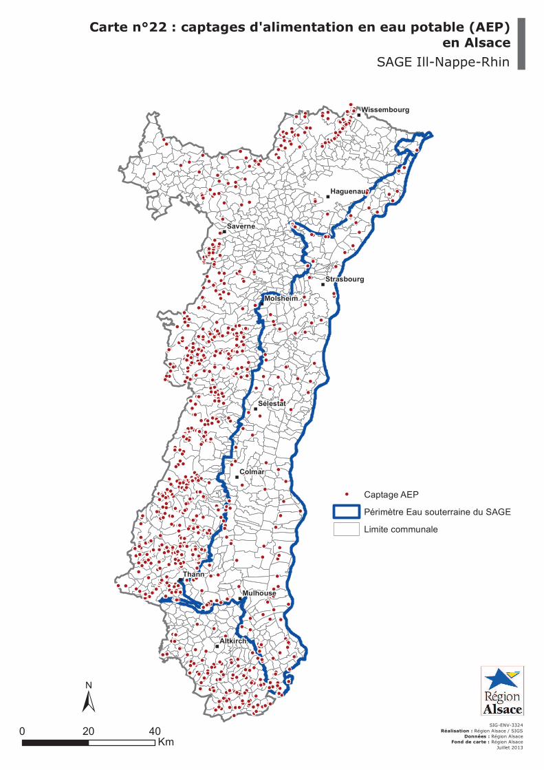
Carte n°22 : captages d'alimentation en eau potable (AEP)en Alsace
SAGE Ill-Nappe-Rhin
SIG-ENV-3324
Réalisation : Région Alsace / SIGSDonnées : Région Alsace
Fond de carte : Région Alsace
Juillet 2013
0 4020Km
±
! Captage AEP
Périmètre Eau souterraine du SAGE
Limite communale
!
!!
!!
!
!!!!
!!!!!!
!!!!!!
!!
!!!!!
!!!
!!!
!!
!
!
!!!
!!
!
!
!
!
!
!!
!!
!!
!
!!!!
!!!!!
!!!!!!
!!
!
!
!!
!
!!!
!!
!
!!!!!
!
!
!!
!
!
!
!!
!
!
!
!
!
!
!!!!!!!!
!!!
!!!!!
!
!!!
!!
!!
!
!
!!!
!!!
!
!!
!!!
!!
!!!
!!!
!
!
!
!
!!
!
!!
!
!!!
!!!!!! !
!
!!!!!
!
!!!!!
!
!
!!!!!!!!!
!!!!!
!!
!!!!!
!!!
!!!!
!!
!!!
!!!
!
!!!!!!
!!
!!!!!
!!!!!!
!!
!
!
!
!!!
!
!
!
!!!
!
!!
!!
!
!!!
!! !
!
!
!
!
!
!!!
!!!!!
!
!!
!
!
!!!!!!!!!
!
!!!!!!!!!!
!!! !
!
!
!!!
!!!!!!
!
!
!!
!!!
!!
!
!!
!
!!
!!!!
!
!!
!!
!!!!!!!
!!!!!!
!
!!!!!!
!!!
!!!!!
!!!!
!
!
!!
!!!
!
!!
!!!
!!
!
!!!!!
!!!!!!
!
!
!!!!
! !
!
!
!!
!!
!
!!!!!!
!!! !!!!
!!
!!!!!
!!!!!
!
! !!
!! !
!
!!!!!!!!!!!
!
!
!
!
!!
!!!!!!!!!!
!
!!!!!!! !
!!!!
!
!!!
!
!!!
!!!
!
!!
!!!
!!!!
!!!!!!
!
!!!
!!!
!
!
!
!
!!!!!
!
!
!!!
!
!
!!!
!!!! !!!!
!!
!!!!! !!
!!!!
!!!!!!!!
!
!!!!!!!!
!
!!!
!
!
!!!!!
!!!!!!!!!!!
!! !!
!
!
!!
! !
!!!!
!!
!
!!!
!
!!!!!
!!!
!!!!
!! !!!
! !!!
!
!!
!!
!
!
!
!
!!
!
!
!!
!!!!!!!!!
!
!!!
!
!
!
!
!!
!
!!!!!!!!!
!
!!
!!!
!!!
!
!
!
!!
!
!!!
!
!
!
!!!!!!!!!
!!
!
!!!
!
!!!!!!!
!!
!!
!
!!!
!!!!
!
!!!!
!
!!!!
!
!
!!
!!
!
!
!!!
!
!!!!
!!
!
!
!!!!!
!
!
!!!!!!
!
!
!
!!!
!
!!!!!!!!
!
!!
!!
!!!!!!!!!
!
!!!
!
!
!!!!!
!!!!!!!!
!!!!!
!!
!!!!
!!!!
!!!
! !!!!!! !
!!!!!
!!!
!
!
!
!!
!
!!!!
!!
!!!!!!!!!!!
!!
!!!!!
!
!!
!
!!!!!
!
!!!!!
!
!!!!
!
!!!
!
!!!
!
!!!
!
!!
!!!
!
!
!
!!
!!!!!!!!
!!!!
!!!!!!!!!
!!
!
!!! !!!
!!!!!
!!!
!!!!
!!!!!
!!!!!!
!
!!!!!!!!!!!!
!
! !!!
!
!!!
!
!!
!!!!!!!
!!!!!!!
!!!
!!!!
!!!!!
!!!!!
!
!!!
!!
!
!
!
!
!!!!!!!!! !!!
!
!!!!
!
!!
!!!!!!!
!
!
!!!
!!!!!!
!!!!!!
!!
!
!!!
!!!!!
!!!
!! !!!!!
!!!
!
!!
!
!!!
!!!
!!!
!!
!!!!!!!
!!
!
!!!!
!
!!!! !!!
!
!!!!!
!!!!!!!!!!
!!
!!
!!!!
!!!!!
!!
!!
!!!
!!!!!
!!!!
!!!!
!!
!!!!
!!!!
!
!!!!!!
!!!
!!!!!!!!
!
!!!!!!!!!
!!!!
!!
!!!!!!
!!!!!!!!
!!!
!!!
!!
!!!
!!
!!
!
!
!!!
!!!!
!
!!!
!
!
!!!!!!!
!!!!! !
!!
!
!!
!
!!
!!!!!!
!
!!!!
!!!!!!!!!!!!!!!!
!!!
!
!!
!
!
!
! !!!!!!
!
!!
!!!
!!!!!!!!!!!!!!!!!!!!!!
!!!!!!!!!!!!! !!!!
!!
!!!!
!!
!
!
!!!
!!
!
!!!
!!!
!
!!!!!!
!!
!!!!!!!!!!
!!!!!!!
!!
!!!!
!
!
!!!!!
!!!!!!!
!!
!
!!!!
!
!!!
!
!!!
!!!!!!
!!!!!!
!!!!!
!
!!!
!!!
!
!!
!!!!
!
!!!!!
!!
!!!!
!
!
!!!!!!
!
!!!!!!!!
!!!!
!!
!!!!!!!!!!
!
!!!!
!!!!!!!!
!
!
!
!
!!!!!! !
!
!!
!
!!!!!!
!!
!
!
!
!!
L'Ill
le R
hin
La Zorn
La B
ruch
e
La F
ech
t
La Lauter
La Thur
L'Andla
u
La Sauer
La Dolle
r
La Largue
L'Eberbach
La
La
uch
La Moder
L'E
ich
el
Le GiessenLa
Sa
rre
L'Isch
can
al d
u R
hôn
e a
u R
hin
dé
cla
ssé
Le Seltzbach
La Mossig
canal d
e la Marne
au R
hin
La L
iepv
rette
La Zinzel du Nord
canal du Rhône au Rhin
Gra
nd C
ana
l d
'Als
ace
Le W
eiss
bach
Le Durrenbach
canal d
e Huning
ue
l'Ill
canal de Colmar
L'Ill
Gra
nd C
ana
l d'A
lsace
La S
arre
La
Thu
r
can
al d
u R
hôn
e a
u R
hin
La Fecht
La Moder
Gra
nd C
ana
l d
'Als
ace
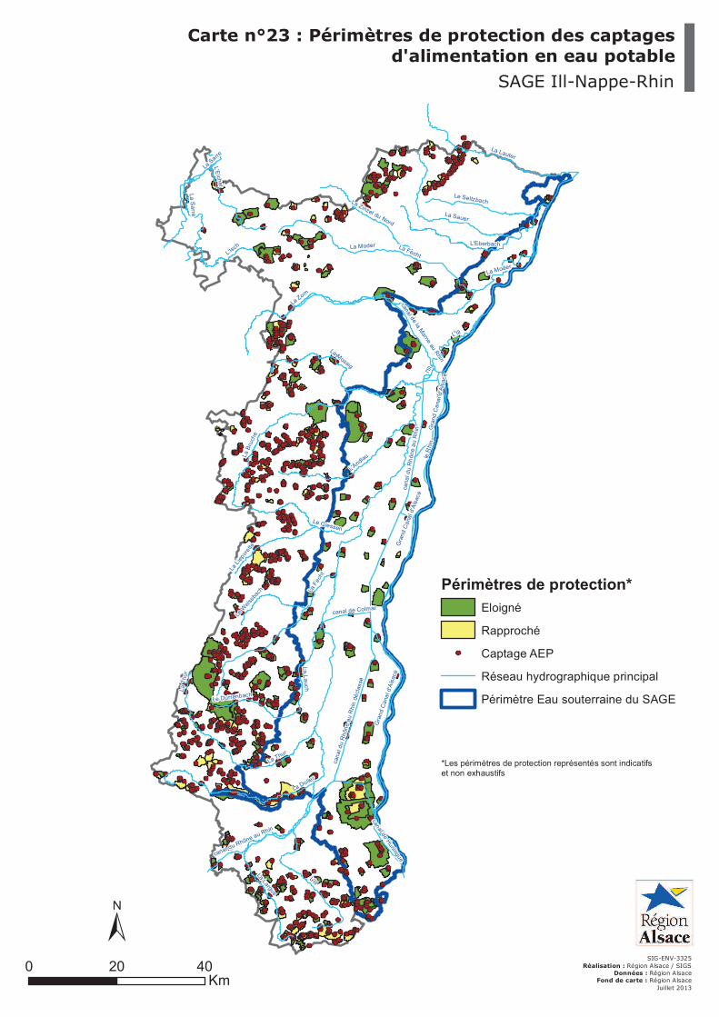
Carte n°23 : Périmètres de protection des captagesd'alimentation en eau potable
SAGE Ill-Nappe-Rhin
SIG-ENV-3325
Réalisation : Région Alsace / SIGSDonnées : Région Alsace
Fond de carte : Région Alsace
Juillet 2013
0 4020Km
±
Périmètres de protection*
Eloigné
Rapproché
! Captage AEP
Réseau hydrographique principal
Périmètre Eau souterraine du SAGE
*Les périmètres de protection représentés sont indicatifset non exhaustifs
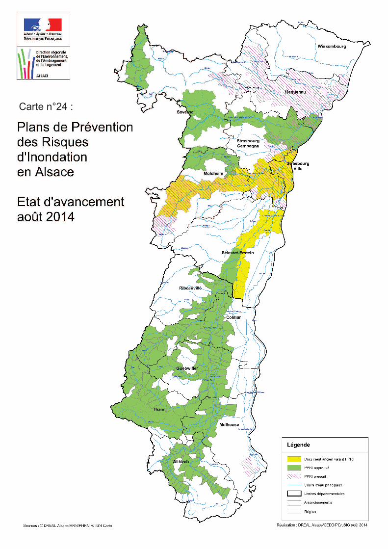
Carte n°24 :
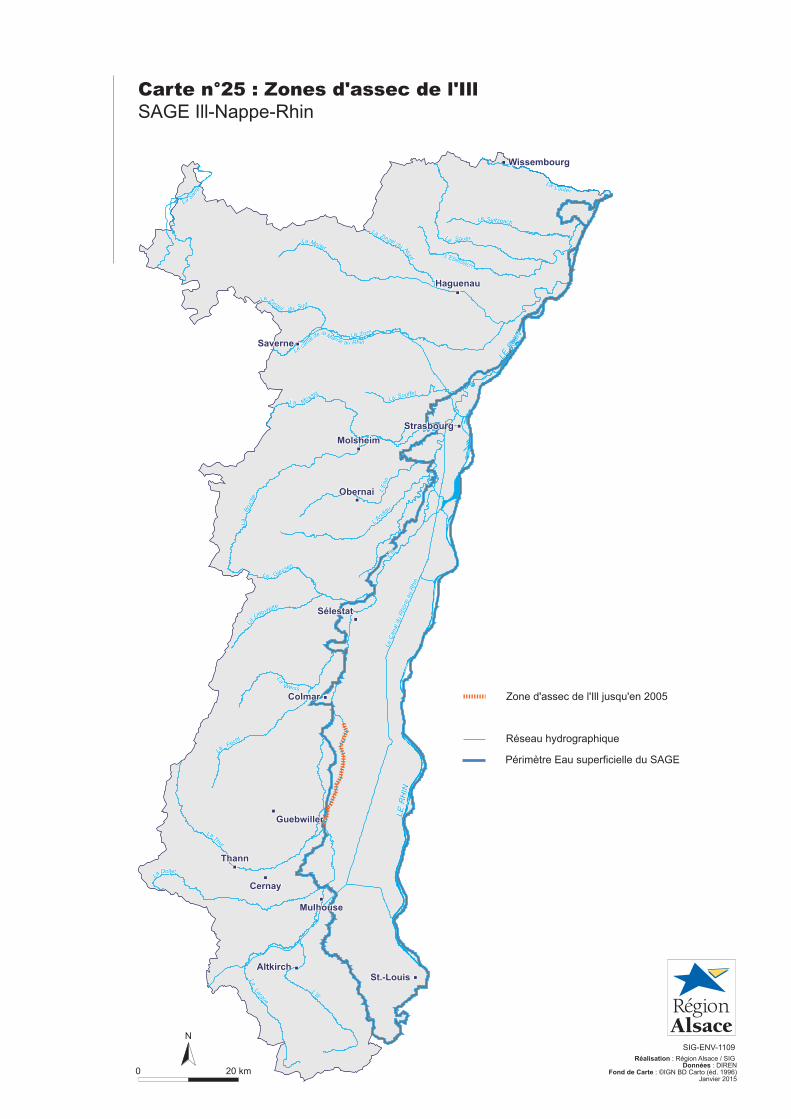
Carte n°25 : Zones d'assec de l'Ill
SAGE Ill-Nappe-Rhin
0 20 km
N
SIG-ENV-1109
Réalisation : Région Alsace / SIGDonnées : DIREN
Fond de Carte : ©IGN BD Carto (éd. 1996)
Réseau hydrographique
Zone d'assec de l'Ill
Périmètre Eau superficielle du SAGE
Lauter
Nord L'Eberbach
Sauer
Seltzbach
Mossig
Zorn
L'And
lauB
ruch
e
Souffel
Zinzel du
Weiss
Lièpvrette
Giessen
Moder
Fecht
Thur
Largue
Doller
La
L'Ill
La
La
Le
La
La
La
La
La La
La
La
LaLa
Le
La
La Sar
re
SudZinzel du
La
Le C
anal d
u R
hône a
u R
hin
L'Ill
LE
RH
IN
RH
IN
LE
Le
de Marne au Rhin
la
canal
L'E
hn
Lauter
Nord L'Eberbach
Sauer
Seltzbach
Mossig
Zorn
L'And
lauB
ruch
e
Souffel
Zinzel du
Weiss
Lièpvrette
Giessen
L'E
hn
Moder
Fecht
Thur
Largue
Doller
La
L'Ill
La
La
Le
La
La
La
La
La La
La
La
LaLa
Le
La
La Sar
re
SudZinzel du
La
Le C
anal d
u R
hône a
u R
hin
L'Ill
LE
RH
IN
RH
IN
LE
Le
de Marne au Rhin
la
canal
Haguenau
Strasbourg
Saverne
Molsheim
Obernai
Sélestat
Colmar
Guebwiller
Cernay
Thann
Mulhouse
St.-Louis
Wissembourg
Altkirch
Haguenau
Strasbourg
Saverne
Molsheim
Obernai
Sélestat
Colmar
Guebwiller
Cernay
Thann
Mulhouse
St.-Louis
Wissembourg
Altkirch
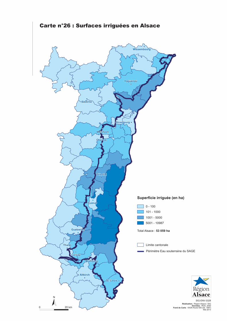
Carte n°26 : Surfaces irriguées en Alsace
0 20 km
N
SIG-ENV-3328
Réalisation : Région Alsace / SIGDonnées : RGA, 2000
Fond de Carte : ©IGN Route 500 (éd. 1997)Mai 2013
1001 - 5000
5001 - 10987
0 - 100
101 - 1000
Superficie irriguée (en ha)
Total Alsace : 53 059 ha
Limite cantonale
Périmètre Eau souterraine du SAGE
Haguenau
Strasbourg
Saverne
Molsheim
Obernai
Sélestat
Colmar
Guebwiller
Cernay
Thann
Mulhouse
St.-Louis
Wissembourg
Altkirch
Haguenau
Strasbourg
Saverne
Molsheim
Obernai
Sélestat
Colmar
Guebwiller
Cernay
Thann
Mulhouse
St.-Louis
Wissembourg
Altkirch
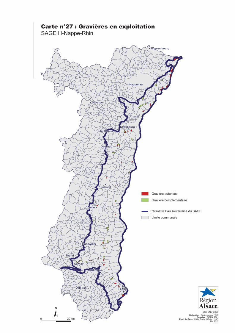
Carte n°27 : Gravières en exploitation
SAGE Ill-Nappe-Rhin
0 20 km
N
SIG-ENV-3329
Réalisation : Région Alsace / SIGDonnées : DIREN, 2001
Fond de Carte : ©IGN Route 500 (éd. 1997)Mai 2013
Limite communale
Gravière complémentaire
Gravière autorisée
Périmètre Eau souterraine du SAGE
Haguenau
Strasbourg
Saverne
Molsheim
Obernai
Sélestat
Colmar
Guebwiller
Cernay
Thann
Mulhouse
St.-Louis
Wissembourg
Altkirch
Haguenau
Strasbourg
Saverne
Molsheim
Obernai
Sélestat
Colmar
Guebwiller
Cernay
Thann
Mulhouse
St.-Louis
Wissembourg
Altkirch
!
!
!
!
!
!
!
!
!
!
Thann
Colmar
Saverne
Mulhouse
Altkirch
Sélestat
Molsheim
Haguenau
Strasbourg
Wissembourg
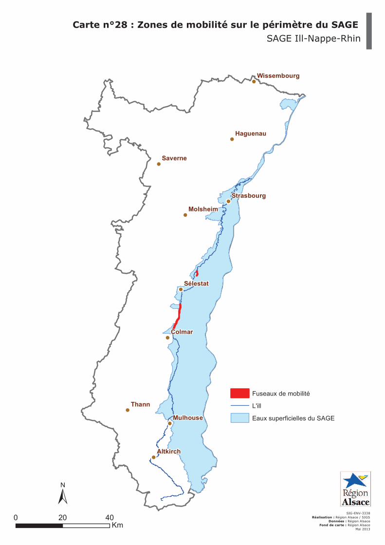
Carte n°28 : Zones de mobilité sur le périmètre du SAGE
SAGE Ill-Nappe-Rhin
SIG-ENV-3338
Réalisation : Région Alsace / SIGSDonnées : Région Alsace
Fond de carte : Région Alsace
Mai 2013
0 4020Km
±
Fuseaux de mobilité
L'ill
Eaux superficielles du SAGE
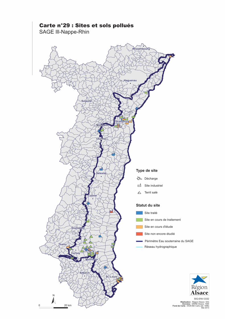
Carte n°29 : Sites et sols pollués
SAGE Ill-Nappe-Rhin
0 20 km
N
SIG-ENV-3332
Réalisation : Région Alsace / SIGDonnées : DRIRE Alsace, 1994
Fond de Carte : ©IGN BD Carto (éd. 1996)Mai 2013
Décharge
Site industriel
Terril salé
Site en cours d'étude
Site non encore étudié
Site traité
Site en cours de traitement
Réseau hydrographique
Type de site
Statut du site
Périmètre Eau souterraine du SAGE
Haguenau
Strasbourg
Saverne
Molsheim
Obernai
Sélestat
Colmar
Guebwiller
Cernay
Thann
Mulhouse
St.-Louis
Wissembourg
Altkirch
Haguenau
Strasbourg
Saverne
Molsheim
Obernai
Sélestat
Colmar
Guebwiller
Cernay
Thann
Mulhouse
St.-Louis
Wissembourg
Altkirch
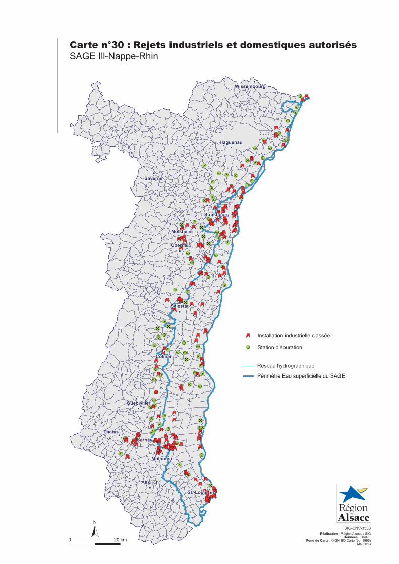
Carte n°30 : Rejets industriels et domestiques autorisés
SAGE Ill-Nappe-Rhin
0 20 km
N
SIG-ENV-3333
Réalisation : Région Alsace / SIGDonnées : DRIRE
Fond de Carte : ©IGN BD Carto (éd. 1996)Mai 2013
Station d'épuration
Installation industrielle classée
Réseau hydrographique
Périmètre Eau superficielle du SAGE
Haguenau
Strasbourg
Saverne
Molsheim
Obernai
Sélestat
Colmar
Guebwiller
Cernay
Thann
Mulhouse
St.-Louis
Wissembourg
Altkirch
Haguenau
Strasbourg
Saverne
Molsheim
Obernai
Sélestat
Colmar
Guebwiller
Cernay
Thann
Mulhouse
St.-Louis
Wissembourg
Altkirch