Embed Size (px)
Citation preview

Draft Environmental Assessment
City of La Feria, Texas Storm Water Pump Station on AN-49
Drainage Channel HMGP-DR1931- TX Project #1 Cameron County, Texas September 2012
Federal Emergency Management Agency Department of Homeland Security 800 North Loop 288 Denton, Texas 76209-3698


Thispageisintentionallyleftblank.

Table of Contents
i
Table of Contents
Section1 Introduction.................................................................................................................................1‐1
Section2 PurposeandNeed......................................................................................................................2‐1
Section3 Alternatives..................................................................................................................................3‐1
3.1NoActionAlternative...............................................................................................................................................3‐1 3.2ProposedAction..........................................................................................................................................................3‐23.3AlternativesConsideredandDismissed..........................................................................................................3‐5
Section4 AffectedEnvironmentandPotentialImpacts....................................................................4‐1
4.1PhysicalResources....................................................................................................................................................4‐1 4.1.1Geology&Soils................................................................................................................................................4‐14.1.2AirQuality.........................................................................................................................................................4‐2
4.2WaterResources.........................................................................................................................................................4‐3 4.2.1WaterQuality...................................................................................................................................................4‐34.2.2WatersoftheU.S.,IncludingWetlands................................................................................................4‐4 4.2.3Floodplains........................................................................................................................................................4‐6
4.3CoastalResources......................................................................................................................................................4‐8 4.4BiologicalResources...............................................................................................................................................4‐10
4.4.1ThreatenedandEndangeredSpeciesandCriticalHabitat........................................................4‐104.4.2WildlifeandFish...........................................................................................................................................4‐13
4.5CulturalResources...................................................................................................................................................4‐14 4.6SocioeconomicResources....................................................................................................................................4‐15
4.6.1EnvironmentalJustice................................................................................................................................4‐154.6.2HazardousMaterial.....................................................................................................................................4‐17 4.6.3Noise..................................................................................................................................................................4‐17 4.6.4Traffic................................................................................................................................................................4‐184.6.5PublicServiceandUtilities......................................................................................................................4‐18 4.6.6PublicHealthandSafety...........................................................................................................................4‐18
4.7SummaryTable.........................................................................................................................................................4‐19
Section5 CumulativeImpactsandMitigation......................................................................................5‐1
Section6 AgencyCoordination,PublicInvolvementandPermits.................................................6‐1
6.3AgencyCoordination................................................................................................................................................6‐16.2PublicParticiaption...................................................................................................................................................6‐2 6.3Permits............................................................................................................................................................................6‐2
Section7 References....................................................................................................................................7‐1
Section8 ListofPreparers..........................................................................................................................8‐1
Table of Contents
ii
Section9 Appendices...................................................................................................................................9‐1
A‐1LowerRioGrandeFloodControlProjectMaps A‐2RioGrandeWildandScenicRiverSegmentMap A‐3U.S.FishandWildlifeServiceWetlandsInventoryMap,LaFeria,Texas A‐4FloodInsuranceRateMap(FIRM),CameronCounty,Texas A‐5U.S.FishandWildlifeServiceCriticalHabitatMap A‐6THCHistoricalPropertiesMap,LaFeria,Texas A‐7EnvirofactsSearchResults,LaFeriaStormWaterPumpStationProposedProjectArea A‐8CorrespondenceDocuments ListofFiguresFigure1ProposedProjectArea(GoogleEarthPro,2012)..................................................................................................1‐2Figure2LaFeria,Texas,August9,2008(FEMA2008)........................................................................................................2‐1Figure3AN‐49ConceptualPlan......................................................................................................................................................3‐3Figure4ProposedStormWaterPumpStationSitePlan......................................................................................................3‐4Figure5AlternativeLocationMap(GoogleEarthPro,2012)............................................................................................3‐5Figure6CoastalBoundaryMap.......................................................................................................................................................4‐9Figure7VegetationatProposedProjectSiteasViewedfromIBWCLevee..............................................................4‐11Figure8Jaguarundi(TPWD)..........................................................................................................................................................4‐12Figure9Ocelot(TPWD)....................................................................................................................................................................4‐12
ListofTablesTable1PropertiesofSoilinProjectArea....................................................................................................................................4‐1Table2USFWSEndangeredSpeciesList(Source:USFWSWebsite)...........................................................................4‐10Table3DemographicDataforProjectArea(Source:2000U.S.Census)...................................................................4‐16Table4PopulationData...................................................................................................................................................................4‐17Table5ImpactsonAffectedEnvironment...............................................................................................................................4‐19Table6AgencyCoordination............................................................................................................................................................6‐1
1‐1
List of Acronyms
APE AreaofPotentialEffectAQCR AirQualityControlRegionsBMP BestManagementPracticesCAA CleanAirActCERCLA ComprehensiveEnvironmentalResponse,Compensation,andLiabilityActCFR CodeofFederalRegulationsCWA CleanWaterActCZMA CoastalZoneManagementActEA EnvironmentalAssessmentESA EndangeredSpeciesActETJ extraterritorialjurisdictionFEMA FederalEmergencyManagementAgencyFIRM FloodInsuranceRateMapFONSI FindingofNoSignificantImpactGLO GeneralLandOfficeHMGP HazardMitigationGrantProgramIBWC InternationalBoundaryandWaterCommissionMBTA MigratoryBirdTreatyActNAAQS NationalAmbientAirQualityStandardsNEPA NationalEnvironmentalPolicyActNRHP NationalRegisterofHistoricPlacesPA ProgrammaticAgreementRCP reinforcedconcretepipeRCRA ResourceConservationandRecoveryActSARA SuperfundAmendmentsandReauthorizationActSHPO StateHistoricPreservationOfficeSWDA SolidWasteDisposalActSWPPP StormWaterPollutionPreventionPlanSWPS StormWaterPumpStationTCEQ TexasCommissiononEnvironmentalQualityTDSHS TexasDepartmentofStateHealthServicesTHC TexasHistoricalCommissionTMDL TotalMaximumDailyLoadTPDES TexasPollutantDischargeEliminationSystemTPWD TexasParksandWildlifeDepartmentTSCA ToxicSubstanceControlActTWDB TexasWaterDevelopmentBoardUSACE UnitedStatesArmyCorpsofEngineersUSEPA UnitedStatesEnvironmentalProtectionAgencyUSFWS UnitedStatesFishandWildlifeServiceWIID WaterInformationIntegrationandDissemination

1‐1
Section 1
Introduction
TheCityofLaFeriainCameronCountyislocatedintheLowerRioGrandeValleyregionofSouthTexas,arelativelyflatterrainareaneartheGulfCoast.LaFerialiesnorthoftheArroyoColoradoinanareawherenaturaloverlanddrainagetotheArroyoColoradoisrestrictedduetotheabsenceofsignificanttopographicreliefandsubstantiallanddevelopment.TributaryinflowstotheArroyoColoradooccurthroughanextensivenetworkofdrainagechannels.Inrecentyears,HurricaneDolly(2008)andHurricaneAlex(2010)havecausedfloodinginLaFeriaandthesurroundingareas.BothDollyandAlexcausedsubstantialfloodinginLaFeriaandresultedininundationofU.S.Highway83,amajorroadwayandthedesignatedevacuationrouteforthisregion.
TheInternationalBoundaryandWaterCommission(IBWC)isaninternationalagencywhichinterpretsandappliestheboundaryandwatertreatiesoftheUnitedStatesandMexico.TheUnitedStatessectionoftheIBWCoperatesandmaintainsthreefloodcontrolsystemsontheRioGrande.TheIBWCisresponsiblefortheLowerRioGrandeFloodControlSystemwhichcontains270milesoffloodcontrolleveesalongtheRioGrande,interiorfloodways,andtheArroyoColorado(AppendixA‐1).TheArroyoColorado,a53‐milenaturalchannelthatbreaksofftheinteriorfloodwayaboutsixmilestothewest,isconfinedbyhighterracesoneachbankandby25milesofleveesthatwereconstructedtoprotecturban,suburban,andhighlydevelopedirrigatedfarmlandsintheRioGrandedeltafromfloods.TheIBWCleveeextendsalongtheArroyoColoradofromtheconfluencewiththeNorthFloodwaytoupstreamoftheCityofLaFeria(AppendixA‐1).AN‐49mustdrainthroughtheIBWCArroyoColoradonorthleveeandthecurrentculvertlocatedhereisasingle24‐inchreinforcedconcretepipe(RCP).ThisstructureisgatedattheleveesoitcanbeclosedbytheIBWCtopreventbackwaterflowwhentheArroyoColoradoisinfloodstageconditions.
Theproposedstormwaterpumpstation(SWPS)onAN‐49drainagechannelwouldbelocatedsoutheastoftheCityofLaFeriawithinitsextraterritorialjurisdictioninsouthwestCameronCounty,Texas(Figure1).ConstructionofthisSWPSwouldenabletheCitytopumpstormwaterovertheIBWCgatetoreducefloodinginLaFeriawhenfloodconditionsrequiretheIBWCgatetobeclosed.
TheCityofLaFeriahaspreparedandsubmittedanapplicationforFederalEmergencyManagementAgency(FEMA)fundingundertheHazardMitigationGrantProgram(HMGP).FEMAisconsideringfundingtheconstructionoftheproposedSWPSprojecttomitigatethefloodhazardinthisarea.TheHMGPisauthorizedunderSection404oftheRobertT.StaffordDisasterReliefandEmergencyAssistanceActwhichisafundingsourceforcost‐effectivemeasuresthatwouldreduceoreliminatethethreatoffuturesimilardamageduringadisaster.
ThisdraftEnvironmentalAssessment(EA)hasbeenpreparedinaccordancewiththeNationalEnvironmentalPolicyAct(NEPA)of1969,thePresident’sCouncilonEnvironmentalQualityregulationstoimplementNEPA(40CodeofFederalRegulationsParts1500‐1508),andFEMA’sregulationsimplementingNEPA(44CFRPart10).FEMAisrequiredtoconsiderpotentialenvironmentalimpactsbeforefundingorapprovingactionsandprojects.ThepurposeofthisdraftEAistoanalyzethepotentialenvironmentalimpactsoftheproposedSWPSproject.FEMAwillusethefindingsinthisdraftEAtodeterminewhethertoprepareanEnvironmentalImpactStatementoraFindingofNoSignificantImpact(FONSI).

Section 1 Introduction
1‐2
Figure 1 Proposed Project Area (Google Earth Pro, 2012)
Section 1 Introduction
1‐3
Thispageisintentionallyleftblank.


2‐1
Section 2
Purpose and Need
TheFederalEmergencyManagementAgency’s(FEMA’s)HazardMitigationGrantProgram(HMGP)providesfundstostateandlocalgovernmentstoimplementlong‐termhazardmitigationmeasuresafteramajordisasterdeclaration.ThepurposeoftheHMGPistoreducethelossoflifeandpropertyduetonaturaldisastersandtoenablemitigationmeasurestobeimplementedduringtheimmediaterecoveryandresponsefromadeclareddisastersuchasforfloodmitigationassistance.TheHMGPisauthorizedunderSection404oftheRobertT.StaffordDisasterReliefandEmergencyAssistanceAct.
ThisprojectisneededtoreducefloodingintheCityofLaFeriaandpartsofthesurroundingunincorporatedareastoitssouthwest.LaFeriaislocatedintheLowerRioGrandeValleyregionneartheGulfCoast.Inrecentyears,HurricaneDolly(2008)andHurricaneAlex(2010)havecausedfloodinginLaFeriaandthesurroundingarea.Whenfacinglarge‐scalestormevents,theCityofLaFeriastormwaterdrainageischallengedbytheflatterrainandlowelevationsassociatedwiththeRioGrandeValleyanditsproximitytotheGulfofMexico.Therelativelyminorterrainslopeallowsstormwatertopondwithlittlechanceofflowinganddrainingefficiently.
TropicalstormsarealsoasignificantthreattotheresidentsofLaFeria,leavingpartsofortheentirecitywithoututilityserviceforweeksormore.Duringaseverestormevent,theIBWCclosesthegatesondrainagechannelstopreventtheriseandbackflowfromtheArroyoColorado.Whenthegatesareclosed,stormwaterrunoffcannotdrainandfloodwatersbackupintotheCity,floodinglocalstreetsandhomesuntiladrainagerouteisaccessible(Figure2).Duringseverestorms,floodingoccursinsectionsofU.S.Highway83,alimitedaccessexpresswayintheCityofLaFeria.ThiseliminatestheuseofU.S.Highway83asahurricaneevacuationrouteformostresidentsofCameronCounty.U.S.
Figure 2 La Feria, Texas, August 9, 2008 (FEMA 2008)

Section 2 Purpose and Need
2‐2
Highway83accommodatesanaverageof74,000vehiclesadayinLaFeriaareaundernormalcircumstances,creatingadangeroussituationwhentheroadwayisnotaccessibleforhazardevacuation.TheCityofLaFeriaisinneedofresourcestocontrolfloodinginthesouthwesternpartofLaFeria’sextraterritorialjurisdictionandpreventfutureflooddamagesandpropertylosses.

3‐1
Section 3
Alternatives
Thissectiondescribesthealternativesconsideredincludingtheproposedaction.AdescriptionofexistingconditionsisincludedunderthenoactionalternativeinSection3.1.
3.1 No Action Alternative Underthe“noaction”alternative,noactionwouldbetakentomitigatefloodhazardsinLaFeria.Thenoactionalternativeprovidesabaselineagainstwhichtomeasurethepositiveandnegativeimpactsoftheactionalternatives.Evaluationofthenoactionalternativeaccountsforlikelyconditionsinthefutureifaprojectisnotimplementedtomitigatefloodhazards.
LaFeriaislocatedwithintheArroyoColoradowatershed.In1935,asystemofdams,levees,andchannelswascompletedintheRioGrandeValleytomitigatefloodhazards.ThesystemissometimescalledtheRioGrandefloodwayandincludestheArroyoColoradonearLaFeria.ThisfloodcontrolsystemisoperatedbytheIBWC,andpartiallydivertsfloodwatersfromtheRioGrandeintoanartificialchannelcalledtheMainNorthFloodwaylocatedabouttenmileswestofLaFeria.FloodingfromtheArroyoColoradoisnotmappedorconsideredarisktotheCityofLaFeria.TheIBWCoperatesleveesalongtheArroyoColoradowhichprotectthesouthwesternportionoftheCityfrominundationduringhighflowontheArroyoColorado.TheIBWCisrequiredtoclosethegatestooutletstructuresalongtheleveeduringhighfloweventstopreventbackflowfromtheArroyoColorado.WhentheIBWCclosesthegates,thisinhibitstheflowofstormwatertoexittheAN‐49drainagechannelthroughthegateandleveestructure.FloodwatersoriginatefromstormwaterrunoffthatisnotabletoexittheAN‐49drainagechannelandentertheArroyoColoradowhenthefloodgatesareclosed.ThishasresultedinlongtermfloodinginmanyportionsoftheCityofLaFeria.
TheCityofLaFeriaexperiencesintenserainfallsfromthunderstorms,tropicaldepressionsandstorms,andhurricanes.TheseintenseraineventsprovideasignificantpotentialforfloodingwithintheCityandthesurroundingarea.Slowlypermeableloamyandclaysoilsandflatlandscapesresultinpoordrainagethatcontributestosustainedflooding.
GiventheconditionsintheCityofLaFeriathatcontributetofloodhazards,ifnoactionistaken,futurefloodingwillcontinueandprolongedinundationwilloccur.FloodingintheCityofLaFeriacompromisespublicsafety,damagesprivatepropertyandcauseshumanhealthimpacts.Intenseraineventscauseinundationofroadways,whichcausesunsafedrivingconditionsandalackofaccessibilitytomajorroadways.
InundationofU.S.Highway83isofparticularconcernbecauseitistheprimarydesignatedevacuationroutefortheCityofLaFeriaduringtropicalstormsandhurricanes.U.S.Highway83isthemaineast‐westcorridorintheLaFeriaarea.In2008,theCityofLaFeriawasseverelyimpactedbyHurricaneDolly.AsaresultoftheheavyrainfallassociatedwithDolly,portionsofU.S.Highway83wereunderfloodwaterformorethanaweek,causingaseveretrafficdisruption.InundationofU.S.Highway83impededevacuationandtheabilityoffirstrespondersandsocialserviceagenciestomobilizeandprovideassistancetoaffectedpopulations.

Section 3 Alternatives
3‐2
Inaddition,ifnoactionistaken,floodinghasthepotentialtocontributetohomesteadfloodingandinundationofagriculturalland.Floodingofagriculturallandmayresultinlossofcropsandlivestock.
3.2 Proposed Action
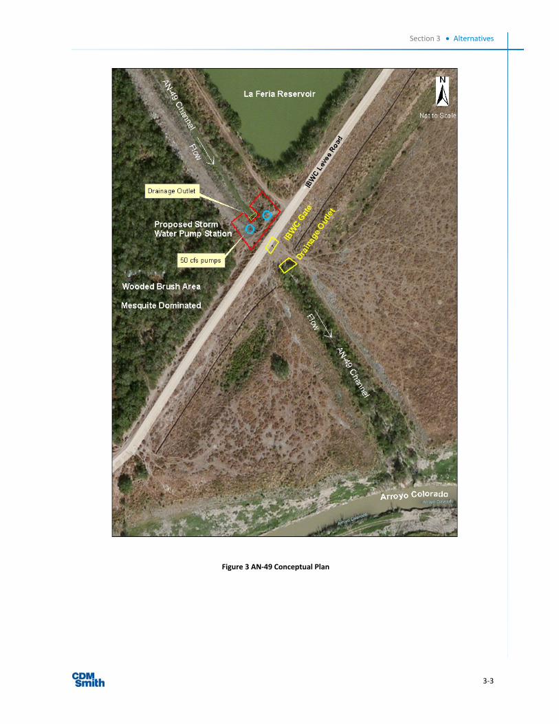
TheCityofLaFeriaproposestoconstructastormwaterpumpstation(SWPS)nearoneoftheIBWCdrainagechannelgateslocatedatthesouthwestendofLaFeriaReservoirtoallowtheCitytopumpstormwaterovertheGate458structureintotheArroyoColorado(Latitude:26.12781N;Longitude:‐97.83966W).TheproposedpumpstationsiteissouthwestoftheCityofLaFeriaandadjacenttothesouthwesterncorneroftheLaFeriaReservoir.Agriculturalareaswithhomesteadslienearthepumpstationsite.Theproposedprojectsiteissituated2.8milessoutheastfromU.S.Highway83andCameronCountyRoad506.TheproposedprojectsiteisoutsideofCitylimitsbutwithinthe5‐mileextraterritorialjurisdiction(ETJ)oftheCityofLaFeria.AccordingtotheCityofLaFeriaPlanningandCommunityDepartment(2012),theprojectsiteisintheETJandisunclassifiedandnoalternativelanduseisplanned.TheproposedprojectsiteisatthesouthendoftheleveewallsofdrainagechannelAN‐49wheretheyjointheIBWCleveejustnorthoftheArroyoColorado.
ConstructionoftheSWPSwouldimprovedrainageduringstormeventsandreducefloodinginsouthwesternLaFeria.Theproposedpumpstationwouldbelocatedwithinanexisting,developedCityofLaFeriadrainageeasementright‐of‐waynorthofandadjacenttotheArroyoColorado.Theproposedpumpstationwouldbeasingle‐storystructurecontainingtwo50cubicfeetpersecondpumpsandassociatedappurtenancestoliftwateroverthegatestructureandthroughthelevee(Figure3).ThechannelhasthecapacitytoaccommodatethisadditionalflowandtheIBWCwouldallowthisquantityoffloodwatertobepumpedintothelowerchannelbelowtheleveeandflowtotheArroyoColorado.Theproposedpumpstationsitewaspreviouslydisturbedwhenthechannelwasconstructedandwouldbetemporarilydisturbedduringconstructionofthepumpstationfacility.TheproposedSWPSismappedalongthewesternLaFeriaReservoirleveeandtheOrangeGrove(AN‐49)irrigationcanalthataredesignatedasFEMA100‐yearFloodplainZonesAandAH,respectively.AsiteplanfortheproposedstormwaterpumpstationisprovidedinFigure4.
Section 3 Alternatives
3‐3
Figure 3 AN‐49 Conceptual Plan

Section 3 Alternatives
3‐4
Figure 4 Proposed Storm Water Pump Station Site Plan (Source: City of La Feria, Engineering Report 2012)

Section 3 Alternatives
3‐5
3.3 Alternatives Considered and Dismissed Duringthealternativesdevelopmentprocess,alternativeswereconsideredbuteliminatedfromdetailedstudy.Thesealternativesandtheirreasonsforeliminationaredescribedinthissection.
Duringselectionoftheproposedsite,analternativelocationoftheproposedSWPSwasconsideredbuteliminated.ThealternativelocationisnearthesouthwestcornerofLaFeriaReservoir,justastheproposedsite,butontheeastsideofthedrainagechannellevee(Figure5).TheeastsideoftheAN‐49drainagechannelleveehasmorepotentialforadverseimpactsonthelevee,providesasmallerlandarea,andprovideslessconvenientaccessforconstructionandmaintenance.Inaddition,duringconstruction,aSWPSlocatedontheeastsideoftheleveecouldcompromisethestructuralintegrityoftheleveewallfortheLaFeriaReservoirthroughvibrationsandlanddisturbance.Thewestbankisthepreferredlocationbecauseitaffordsmorespaceandismoreeasilyaccessibleformaintenanceandconstruction.
Figure 5 Alternative Location Map (Google Earth Pro, 2012)

4‐1
Section 4
Affected Environment and Potential Impacts
Thissectiondescribestheenvironmentthatmaybeaffectedbytheproposedactionoranyoftheotheralternativesconsidered.
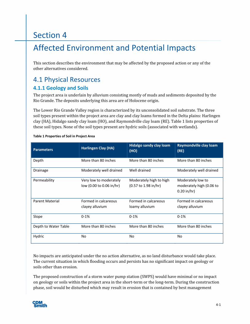
4.1 Physical Resources 4.1.1 Geology and Soils TheprojectareaisunderlainbyalluviumconsistingmostlyofmudsandsedimentsdepositedbytheRioGrande.ThedepositsunderlyingthisareaareofHoloceneorigin.
TheLowerRioGrandeValleyregionischaracterizedbyitsunconsolidatedsoilsubstrate.ThethreesoiltypespresentwithintheprojectareaareclayandclayloamsformedintheDeltaplains:Harlingenclay(HA),Hidalgosandyclayloam(HO),andRaymondvilleclayloam(RE).Table1listspropertiesofthesesoiltypes.Noneofthesoiltypespresentarehydricsoils(associatedwithwetlands).
Table 1 Properties of Soil in Project Area
Parameters Harlingen Clay (HA) Hidalgo sandy clay loam
(HO)
Raymondville clay loam
(RE)
Depth More than 80 inches More than 80 inches More than 80 inches
Drainage Moderately well drained Well drained Moderately well drained
Permeability Very low to moderately
low (0.00 to 0.06 in/hr)
Moderately high to high
(0.57 to 1.98 in/hr)
Moderately low to
moderately high (0.06 to
0.20 in/hr)
Parent Material Formed in calcareous
clayey alluvium
Formed in calcareous
loamy alluvium
Formed in calcareous
clayey alluvium
Slope 0‐1% 0‐1% 0‐1%
Depth to Water Table More than 80 inches More than 80 inches More than 80 inches
Hydric No No No
Noimpactsareanticipatedunderthenoactionalternative,asnolanddisturbancewouldtakeplace.Thecurrentsituationinwhichfloodingoccursandpersistshasnosignificantimpactongeologyorsoilsotherthanerosion.
Theproposedconstructionofastormwaterpumpstation(SWPS)wouldhaveminimalornoimpactongeologyorsoilswithintheprojectareaintheshort‐termorthelong‐term.Duringtheconstructionphase,soilwouldbedisturbedwhichmayresultinerosionthatiscontainedbybestmanagement

Section 4 Affected Environment and Potential Impacts
4‐2
practices(BMPs)controls.TheproposedprojectsiteisnotcurrentlyusedasfarmlandandisnotsubjecttotheFarmlandProtectionPolicyActbecauseitisalreadycommittedtowaterstorage(7CFR658.2(a)).
4.1.2 Air Quality TheCleanAirAct(CAA),asamendedin1977and1990,providesthebasisforregulatingairemissionsintheatmosphere.TheCAA,Title42,Section7407oftheU.S.CodestatesthatAirQualityControlRegions(AQCR)shallbedesignatedininterstateandmajorintrastateareasasdeemednecessaryorappropriatebyfederaladministratorforattainmentandmaintenanceoftheNationalAmbientAirQualityStandards(NAAQS).TheU.S.EnvironmentalProtectionAgency(USEPA)classifiesairqualitywithinanAQCRaccordingtowhethertheconcentrationsofcriteriaairpollutantsintheatmosphereexceedprimaryorsecondaryNAAQS.
TheproposedprojectareaislocatedinsouthwestCameronCounty.TheUSEPAdesignatesthisregionasbeinginattainmentofallNAAQS.TheUSEPAairqualitymonitoringstationslocatedintheregionhavenotdetectedlevelsofpollutantsexceedingairqualitystandards.
Noimpactsareanticipatedunderthenoactionalternative,becausenochangeswouldoccurtothelevelofairemissions.Airqualityimpactsfromconstructionactivitiesassociatedwiththeproposedprojectwouldbelocalizedandtemporary,occurringoveraperiodofafewmonthsneartheproposedprojectsite.Duringprojectconstructionactivities,measuressuchaswettingthesoil,limitingunnecessaryidlingofconstructionvehicles,maintainingvehiclesinproperworkingcondition,andshuttingdownconstructionmachinesthatarenotinusewouldbeemployedtominimizethetemporaryairqualityimpactsfromconstructionactivities.ThecompletedSWPSwouldnotbeasignificantsourceofairpollutants.
PostconstructionroutinemaintenancefortheproposedSWPSisexpectedtobemoderateandwouldnotresultinasignificantincreaseinemissionsofpollutants.TheCityofLaFeriaisalreadyconductingroutinemaintenanceontheproposedsiteandthelevelofmaintenanceisnotexpectedtoincreasesignificantlyiftheproposedactionisapproved.

Section 4 Affected Environment and Potential Impacts
4‐3
4.2 Water Resources 4.2.1 Water Quality SurfaceWaterSections303(d)and305(b)oftheCleanWaterAct(CWA)requireallstatestoidentifyandcharacterizewatersthatdonotmeet,orarenotexpectedtomeet,waterqualitystandards.TheTexasCommissiononEnvironmentalQuality(TCEQ)istheregulatoryagencyresponsibleforcompliancewithwaterqualitystandardsinTexas.TheTCEQ’s2010IntegratedReportforCWASections303(d)and305(b)characterizesthequalityofTexassurfacewatersandidentifiesthosewatersthatdonotmeetwaterqualitystandardsonthe303(d)list,aninventoryofimpairedwaters.Streamsareclassifiedbysegmentwithintheirrespectivebasin.
TheArroyoColorado,theproposedproject’sreceivingwaterbody,comprisesSegments2201and2202.Bothsegmentshaveconsistentlyfailedtomeetwaterqualitystandards.TheproposedprojectareaiswithinSegment2202,thenon‐tidalsegmentoftheArroyoColoradolocatedupstreamofthePortofHarlingen.Segment2202isgovernedbyaTotalMaximumDailyLoad(TMDL)programforlegacypollutantsandorganics.Legacypollutantsaresubstancesnowbannedthatremaininthewatershedanditsenvironmentbecauseoftheirlowrateofdecomposition.
Waterqualityissuesinthenon‐tidalSegment2202oftheArroyoColoradoincludehighconcentrationsoffecalbacteriaandnutrientssuchasnitrogenandphosphoruscompounds(ArroyoColoradoWatershedPartnership2007).Waterqualityanalysesidentifiedseveralpollutantsinfishtissue(e.g.DDE,mercury,andPCBs)atconcentrationswarrantingafishconsumptionadvisoryforthesegmentsupstreamfromthePortofHarlingen(TCEQ2003;TDSHS2008).
Underthenoactionalternative,therewouldbenoimpactstowaterquality.WaterqualityinSegments2201and2202wouldresemblecurrentconditions.
Theproposedprojectareaisnotlocatednearanyriversegmentdesignatedas“wildandscenic”.TheRioGrandeisdesignatedasa“wildandscenic”riverstartingattheCoahuila/ChihuahuastateborderinMexicoandextending191milesdownstreamtotheTerrellCounty/ValVerdeCountylineinTexasasshowninAppendixA‐1(InteragencyWildandScenicRiversCouncil2011).
Theproposedprojectcouldhaveshortterm,localizedimpactstosurfacewateroftheArroyoColorado,occurringoveraperiodofafewmonths.SWPSconstructionactivitiesareexpectedtoremovevegetationattheproposedprojectsite,whichcouldresultinsomesoilerosionduringheavyprecipitationevents.Bestmanagementpractices(BMPs)wouldbeusedtopreventsedimentorconstructiondebrisfrombeingtransportedintotheArroyoColorado,includingsiltfencesorothererosioncontroldevicessuchastemporaryerosionblanketsonslopes.InaccordancewiththerequiredTexasPollutantDischargeEliminationSystem(TPDES)stormwaterpermit(TXR150000),specificmeasureswouldbeimplementedtominimizetheimpactsfromconstructionactivities.BMPswouldbedevelopedaspartofthesite‐specificstormwaterpollutionpreventionplan(SWPPP)andimplementedincompliancewithallfederal,state,andlocalregulations,includingSections402oftheCWA,rulesestablishedundertheTitle30TexasAdministrativeCodeandtheArroyoColoradoWatershedPartnershipProtectionPlan.TheproposedprojectwouldnotgenerateanyoftheTMDLwaterpollutantsofparticularconcerninSegment2202oftheArroyoColorado.

Section 4 Affected Environment and Potential Impacts
4‐4
GroundwaterThemajoraquiferunderlyingtheproposedprojectareaistheGulfCoastaquifer.Theaquiferconsistsofdiscontinuousbedsofclay,silt,sand,andgravelthatarehydrologicallyconnectedtoformalarge,leakyartesiansystem.TheGulfCoastaquiferspansacross54TexascountiesalongthecoastlinebeltoftheGulfofMexicofromLouisianatoMexico.WaterqualityissuesassociatedwiththeGulfCoastaquiferincludeland‐surfacesubsidence,increasedchloridecontentinthegroundwaterfromthesouthwesternportionoftheaquifer,andsaltwaterintrusionalongthecoast(TWDB2006).WaterqualityintheaquiferistypicallygoodtothenorthoftheSanAntonioRiverBasin,whiletothesouthtowardsMexicohighsalinityandalkalinityarecommon,makingmuchofthewaterunsuitableforirrigation(AshworthandHopkins1995).
AdatasearchontheTexasWaterDevelopmentBoard(TWDB)WaterInformationIntegrationandDissemination(WIID)SystemwasconductedonJune14,2012.TheWIIDSystemprovidesgroundwaterdataandsubmittedwaterwelldrillerreports.Withintheareaofconcern,nowaterwellswereidentifiedandnogroundwaterqualitydataisavailable.
Underthenoactionalternative,therewouldbenoimpactstogroundwaterqualityasnoconstructionwouldtakeplace.
ShorttermminorimpactstogroundwateroftheGulfCoastAquifermayoccurasaresultofactivitiesassociatedwiththeproposedconstructionwork.SWPSconstructionactivitiesareexpectedtoremovevegetationasneededattheproposedprojectsite,whichcouldresultinminorsoilerosionduringheavyprecipitationevents.BMPs,asneeded,wouldbeusedtopreventsedimentorconstructiondebrisfrombeingtransportedtotheArroyoColoradoincludingtheuseofsiltfencesorothererosioncontroldevicessuchastemporaryerosionblankets.
4.2.2 Waters of the U.S., Including Wetlands TheNationalEnvironmentalPolicyAct’s(NEPA)basicpolicyistoassurethatallbranchesofthefederalgovernmentgiveproperconsiderationtotheenvironmentpriortoundertakinganymajorfederalactionthatsignificantlyaffectstheenvironment.NEPArequiresfederalagenciestointegrateenvironmentalvaluesintothedecisionmakingprocessbyconsideringtheenvironmentalimpactofproposedactionsandreasonablealternativestothoseactions.TomeetNEPArequirements,federalagenciesprepareanEAthatprovidesevidenceandanalysisfordeterminingwhethertoprepareanEnvironmentalImpactStatement(EIS)oraFindingofNoSignificantImpact(FONSI).
NEPA,incombinationwiththeCleanWaterAct(CWA),establishesthatwherethequalityofawaterresourcesupportsadiverse,productive,andecologicallysoundhabitat,itisanationalpolicythatthosewaterswillbemaintainedandprotectedunlessthereiscompellingevidencethattodosowillcausesignificantnationaleconomicandnegativesocialimpacts.ThisnationalpolicyisfoundedontheCWAprimaryprinciplestorestoreandmaintainthechemical,physical,andbiologicalintegrityofthenation’ssurfaceandgroundwaters.Thepurposeofthispolicyistoprotectexistingandfuturewaterusesincludingassimilativecapacity,aquaticlifeprotection,humanhealthprotection,drinkingwatersupply,recreation,industrialuse,andhydropoweramongothers.
ThebasisoftheCWAwasoriginallyenactedin1948astheFederalWaterPollutionControlAct,andhasbeenamendednumeroustimes.The1972amendmentsestablishedanationalgoalthatwatersoftheU.S.shouldbe“fishableandswimmable”;thisgoalwastobeachievedbyeliminatingallpollutantdischargesintosurfacewatersoftheU.S.“WatersoftheUS”aredefinedintheCWA;however,recent

Section 4 Affected Environment and Potential Impacts
4‐5
U.S.SupremeCourtdecisionshaveledtoachangeinthedefinition.TheUSEnvironmentalProtectionAgency(USEPA)andtheUSArmyCorpsofEngineers(USACE)releasedproposedguidancetoclarifyprotectionofwatersundertheCWA.Partofthisguidanceisfocusedonprotectionofsmallerwatershedsthatfeedintolargerbasins,tokeepdownstreamwatersafefromupstreampollution.Thefocusisalsoontheprotectionofjurisdictionalwetlandsthatfilterpollutantsandstorewaterandprovidefloodprotection.TheguidancewillnotextendfederalprotectiontoanywatersnothistoricallyprotectedundertheSections10and404oftheCWAandwillbefullyconsistentwiththelaw,includingrecentSupremeCourtdecisions.
Section404oftheCWAestablishedaprogramtoregulatethedischargeofdredgedorfillmaterialinto“watersoftheUS”andisjointlyadministeredbytheUSEPAandUSACE.USACEadministersday‐to‐dayprogramoperations,includingindividualpermitdecisionsandjurisdictionaldeterminations;developspolicyandguidance;andenforcesSection404provisions.USEPAdevelopsandinterpretsenvironmentalcriteriausedinevaluatingpermitapplications,identifiesactivitiesthatarerequiredorareexemptfrompermitting,reviewsandcommentsonindividualpermitapplications,enforcesSection404provisions,andhasauthoritytovetoUSACEpermitdecisions.
No“watersoftheUS”arepresentattheprojectsite;therefore,nocoordinationwouldbenecessarybetweentheCityofLaFeriaandtheUSACEregardingtheproposedproject.USACEGalvestonDistrictdoesnottakejurisdictionoftheAN‐49drainagechannel.TheIBWChasjurisdictionoverthefloodgate(Structure458)locatedonthenorthleveeoftheArroyoColoradoandcoordinationwiththeIBWCisnecessarytopumpstormwateroverthefloodgate.OnMarch27,2012,theIBWCissuedarevocablelicensetotheCityofLaFeriatoconstruct,operate,andmaintainadrainagestructureonthenorthleveeoftheArroyoColoradoFloodway.
TheU.S.FishandWildlifeService’s(USFWS)NationalWetlandsInventorymapfortheprojectarea,inAppendixA‐3,indicatestherearenowetlandsonthelanddirectlyaffectedbytheproposedaction.Fourwetlandsarelocatedwithin½to1mileoftheproposedprojectsitebutwouldnotbeimpactedbytheproposedSWPSfacility.Inaddition,basedontheNaturalResourcesConservationService’sonlineWebSoilSurveyforCameronCounty,noneoftheproposedprojectareacontainshydricsoils.
Underthenoactionalternative,noSWPSconstructionwouldoccurandtherewouldbenoimpacttothenearbywetlands.
Undertheproposedactionconstructionwouldoccurwithoutanyimpactonnearbywetlands.Inaddition,thelong‐termimpactsassociatedwithfacility’soperationandmaintenancewouldhavenoeffectonnearbywetlands.TheCityofLaFeriawillensurethatBMPsareimplementedtopreventerosionandsedimentationtosurrounding,nearbyoradjacentwetlands.ThisincludesequipmentstorageandstagingofconstructiontopreventerosionandsedimentationtoensurethatwetlandsarenotadverselyimpactedpertheCleanWaterActandExecutiveOrder11990.

Section 4 Affected Environment and Potential Impacts
4‐6
4.2.3 Floodplains TheFEMAfloodinsuranceratemap(FIRM)fortheprojectarea,aportionofCommunity‐PanelNumber4801010225B,datedSeptember15,1983,isincludedinAppendixA‐4.Aportionoftheproposedprojectareaisinthe100‐yearfloodplainoftheArroyoColoradoinfloodzoneAH.ZoneAHisanareawithinthe100‐yearfloodplainthatissubjecttoshallowfloodingwhereaveragedepthsarebetweenoneandthreefeet.
ExecutiveOrder11988requiresfederalagencies“toavoidtotheextentpossiblethelongandshorttermadverseimpactsassociatedwiththeoccupancyandmodificationofthefloodplainandtoavoiddirectorindirectsupportoffloodplaindevelopmentwhereverthereisapracticablealternative.”FEMA’simplementingregulationsat24CFRPart9includeaneightstepdecisionmakingprocessforcompliancewithExecutiveOrder11988.
ThiseightstepprocesshasbeencompletedfortheproposedSWPS,assummarizedbelow.
Thecurrentconditionswouldberetainedunderthe“noaction”alternative,maintainingthecurrentleveloffloodprotection.Thecurrentleveloffloodprotectionmaybeinsufficienttoprotectthecommunityandmayposeriskstopersonalsafetyandpropertyduringmajorstorms.
Step1Determineiftheproposedactionislocatedinthe100‐yearFloodplain
TheproposedSWPSwouldbelocatedwithinthe100‐yearfloodplainperFIMRpanel4801010225B,datedSeptember15,1983.
Step2Earlypublicnotice(preliminarynotice)
ApublicnoticeconcerningtheproposedSWPSwillbepublishedintheLaFeriaNewstogetherwiththenoticeofavailabilityofthedraftEnvironmentalAssessment(EA)document.TheLaFeriaNewsisthelocalgeneralcirculationnewspaperfortheLaFeriaarea,includingtheproposedSWPSsite.
Step3Identifyandevaluatealternativestolocatinginthe100‐yearfloodplain
TheproposedSWPSissitedinthe100‐yearfloodplainbecausefloodhazardsarelocatedwithinthefloodplain.Stormwaterbacksupandpoolsintheprojectarea,causingfloodhazards.TheSWPSneedstobelocatedwithinthefloodplaininordertoreceivefloodwaterbygravityandpumpitovertheleveeintotheArroyoColorado.RelocatingtheSWPSoutsideofthefloodplainisnotapracticablealternative.Thenoactionalternativewouldretainexistingconditionsinwhichfloodingduringstormeventscausesfloodhazards.Thenoactionalternativeisnotpracticablebecauseitdoesnotaddressthepurposeandneedfortheproject.
Step4Identifyimpactsofproposedactionassociatedwithoccupancyormodificationofthefloodplain
TheproposedSWPSwouldnotaffectthefunctionofthe100‐yearfloodplain.TheproposedSWPSwouldplaceasmallstructureinthe100‐yearfloodplain;however,thisstructurewouldnotimpedeflows.TheproposedSWPSwouldnotfacilitatedevelopmentwithinthe100‐yearfloodplain.Anynewdevelopmentwithinfloodplainswouldberequiredtocomplywithapplicableordinancesandbuildingcodes.

Section 4 Affected Environment and Potential Impacts
4‐7
TheproposedSWPSislocatedinthemapped100‐yearfloodplain,andisdesignedtobesubmergedandtofunctionduringfloodconditions.
Step5Designormodifytheproposedactiontominimizethreatstolifeandpropertyandpreservenaturalandbeneficialfloodplainvalues
Atthistime,preliminaryplanninghasbeencompletedfortheproposedSWPSandafloodstudyhasbeenprepared.TheproposedSWPSwouldbedesignedtomitigatefloodhazards,andwouldconsistoftwopumpsdesignedforthe25yearstormandcapableofpumping22,000gallonsperminute.ThelowestflooroftheSWPSwouldbedesignedatorabovethelevelofthebaseflood.TheCityofLaFeriamustcoordinatewiththelocalfloodplainadministratorandobtainrequiredpermitspriortoinitiatingwork.AllcoordinationpertainingtotheseactivitiesandapplicantcompliancewithanyconditionsshouldbedocumentedandcopiesforwardedtothestateandFEMAforinclusioninthepermanentprojectfiles
Step6Re‐evaluatetheproposedaction
Theproposedprojectwillnotexposeanysegmentofthepopulationtofloodhazardsbecauseitdoesnotincludeahousingcomponent,andwillnotfacilitatedevelopmentinthefloodplain.TheprojectwillnotaggravatethecurrentfloodhazardbecausetheproposedSWPSwouldnotimpedeorredirectfloodflowsinthefloodplain.Theproposedprojectwillnotdisruptfloodplaincharacteristicsbecauseitwillnotperceptiblychangewaterlevelsinthefloodplain,andwillnotappreciablyreducehabitatareasinthefloodplain.TheanalysiscompletedinSteps4and5providenobasisformodifyingthepreliminaryconclusionreachedinStep3.
Alternativesconsistingoflocatingtheprojectoutsideofthefloodplainortaking“noaction”arenotviable.
Step7Findingsandpublicexplanation(finalnotification)
Afterevaluatingalternatives,impactsandmitigationopportunities,itwasconcludedthattheproposedactionisthemostviablealternativeandthatthereisnopracticablealternativetolocatingaportionoftheprojectinthe100‐yearfloodplainoftheArroyoColoradobecause
Aportionofthecommunityisinthe100‐yearfloodplain,includingmajorroadsandevacuationroutes.
Theproposedpumpstationmustbelocatedwithinthe100‐yearfloodplainbecausethereisnopracticablealternativethatwouldmitigatefloodhazards.
A“noaction”planwouldnotresolveorimprovetheexistingfloodhazardsintheCityofLaFeria
TheCityofLaFeriamustprepareandprovidePublicNoticeissuedfor30daysofpublicavailabilitytoreviewtoproject’sdraftenvironmentalassessment(EA).AseparatePublicNoticemustbepublished15dayspriortothestartofconstructionanyfinaldecisionwhereproposedfloodplainorwetlandprojectistheonlypracticablealternative.
Step8Implementtheaction
ImplementationoftheproposedSWPSprojectwouldnotresultinanincreaseinfloodlevels;ratherimplementingthisprojectwouldalleviatefloodhazardsinthefloodplain.Moreover,theproposedprojectwillbeimplementedtoensurecompliancewithmitigationrequirementsin44CFR9.11

Section 4 Affected Environment and Potential Impacts
4‐8
4.3 Coastal Resources TheCoastalZoneManagementAct(CZMA)enablescoastalstatestodesignatestatecoastalzoneboundariesanddevelopcoastalmanagementprogramstoimproveprotectionofsensitiveshorelineresourcesandguidesustainableuseofcoastalareas.TheTexasCoastalManagementProgramisadministeredbyTexasGeneralLandOffice(GLO).TheTexasGLOdesignatedcoastalzoneboundaryrunsthroughtheeasternhalfofCameronCounty.
Theproposedprojectsiteislocated40milesinlandandwestofthenearestdesignatedcoastalresource,PadreIslandNationalSeashore.Theproposedsitelies12mileswestandinlandfromtheTexasCoastalManagementZoneboundarythatrunsjusteastofHarlingenasdesignatedbytheGLO.Thus,therewouldnotbeanypotentialimpacttocoastalresourcesfromtheproposedproject.Inaddition,thenoactionalternativewillnotresultinanyimpactstoTexascoastalresources.TheTexasCoastalZonemapispresentedinFigure6.

Section 4 Affected Environment and Potential Impacts
4‐9
Figure 6 Coastal Boundary Map
Section 4 Affected Environment and Potential Impacts
4‐10
4.4 Biological Resources VegetationandwildlifecommunitiesintheAreaofConcernandfederal‐listedthreatenedandendangeredspeciesresidingandthatoccurintheAreaofConcernarediscussedinthissection.
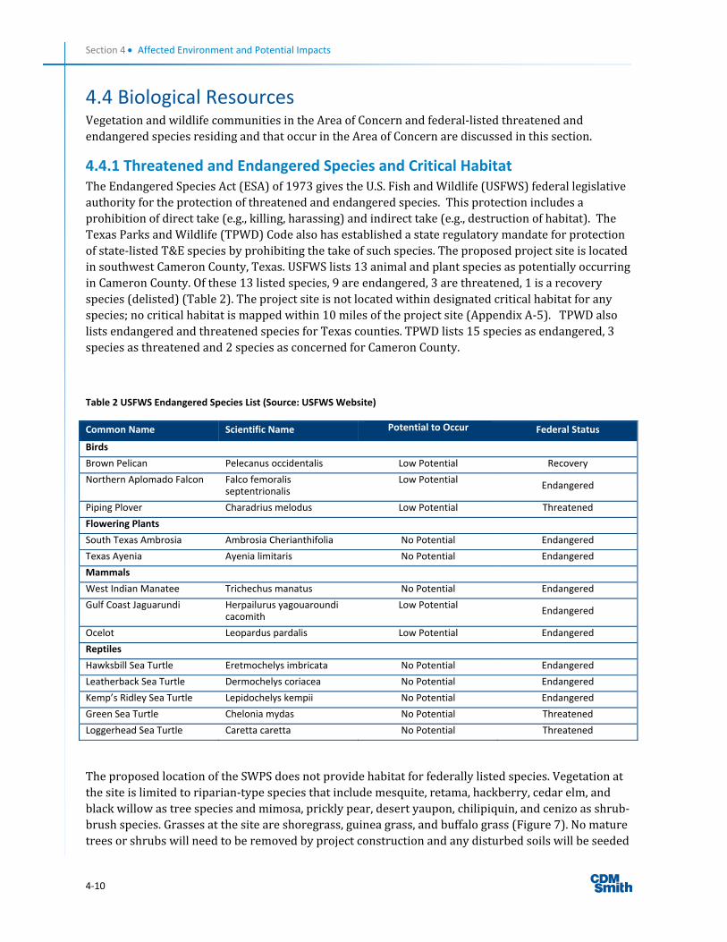
4.4.1 Threatened and Endangered Species and Critical Habitat TheEndangeredSpeciesAct(ESA)of1973givestheU.S.FishandWildlife(USFWS)federallegislativeauthorityfortheprotectionofthreatenedandendangeredspecies.Thisprotectionincludesaprohibitionofdirecttake(e.g.,killing,harassing)andindirecttake(e.g.,destructionofhabitat).TheTexasParksandWildlife(TPWD)Codealsohasestablishedastateregulatorymandateforprotectionofstate‐listedT&Especiesbyprohibitingthetakeofsuchspecies.TheproposedprojectsiteislocatedinsouthwestCameronCounty,Texas.USFWSlists13animalandplantspeciesaspotentiallyoccurringinCameronCounty.Ofthese13listedspecies,9areendangered,3arethreatened,1isarecoveryspecies(delisted)(Table2).Theprojectsiteisnotlocatedwithindesignatedcriticalhabitatforanyspecies;nocriticalhabitatismappedwithin10milesoftheprojectsite(AppendixA‐5).TPWDalsolistsendangeredandthreatenedspeciesforTexascounties.TPWDlists15speciesasendangered,3speciesasthreatenedand2speciesasconcernedforCameronCounty.
Table 2 USFWS Endangered Species List (Source: USFWS Website)
Common Name Scientific Name Potential to Occur Federal Status
Birds
Brown Pelican Pelecanus occidentalis Low Potential Recovery
Northern Aplomado Falcon Falco femoralis septentrionalis
Low PotentialEndangered
Piping Plover Charadrius melodus Low Potential Threatened
Flowering Plants
South Texas Ambrosia Ambrosia Cherianthifolia No Potential Endangered
Texas Ayenia Ayenia limitaris No Potential Endangered
Mammals
West Indian Manatee Trichechus manatus No Potential Endangered
Gulf Coast Jaguarundi Herpailurus yagouaroundi cacomith
Low PotentialEndangered
Ocelot Leopardus pardalis Low Potential Endangered
Reptiles
Hawksbill Sea Turtle Eretmochelys imbricata No Potential Endangered
Leatherback Sea Turtle Dermochelys coriacea No Potential Endangered
Kemp’s Ridley Sea Turtle Lepidochelys kempii No Potential Endangered
Green Sea Turtle Chelonia mydas No Potential Threatened
Loggerhead Sea Turtle Caretta caretta No Potential Threatened
TheproposedlocationoftheSWPSdoesnotprovidehabitatforfederallylistedspecies.Vegetationatthesiteislimitedtoriparian‐typespeciesthatincludemesquite,retama,hackberry,cedarelm,andblackwillowastreespeciesandmimosa,pricklypear,desertyaupon,chilipiquin,andcenizoasshrub‐brushspecies.Grassesatthesiteareshoregrass,guineagrass,andbuffalograss(Figure7).Nomaturetreesorshrubswillneedtoberemovedbyprojectconstructionandanydisturbedsoilswillbeseeded
Section 4 Affected Environment and Potential Impacts
4‐11
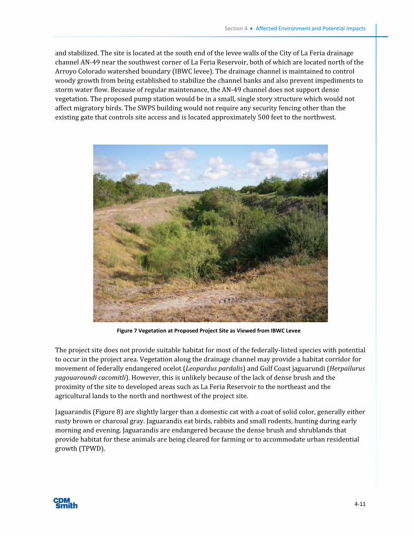
andstabilized.ThesiteislocatedatthesouthendoftheleveewallsoftheCityofLaFeriadrainagechannelAN‐49nearthesouthwestcornerofLaFeriaReservoir,bothofwhicharelocatednorthoftheArroyoColoradowatershedboundary(IBWClevee).Thedrainagechannelismaintainedtocontrolwoodygrowthfrombeingestablishedtostabilizethechannelbanksandalsopreventimpedimentstostormwaterflow.Becauseofregularmaintenance,theAN‐49channeldoesnotsupportdensevegetation.Theproposedpumpstationwouldbeinasmall,singlestorystructurewhichwouldnotaffectmigratorybirds.TheSWPSbuildingwouldnotrequireanysecurityfencingotherthantheexistinggatethatcontrolssiteaccessandislocatedapproximately500feettothenorthwest.
Theprojectsitedoesnotprovidesuitablehabitatformostofthefederally‐listedspecieswithpotentialtooccurintheprojectarea.Vegetationalongthedrainagechannelmayprovideahabitatcorridorformovementoffederallyendangeredocelot(Leoparduspardalis)andGulfCoastjaguarundi(Herpailurusyagouaroundicacomitli).However,thisisunlikelybecauseofthelackofdensebrushandtheproximityofthesitetodevelopedareassuchasLaFeriaReservoirtothenortheastandtheagriculturallandstothenorthandnorthwestoftheprojectsite.
Jaguarandis(Figure8)areslightlylargerthanadomesticcatwithacoatofsolidcolor,generallyeitherrustybrownorcharcoalgray.Jaguarandiseatbirds,rabbitsandsmallrodents,huntingduringearlymorningandevening.Jaguarandisareendangeredbecausethedensebrushandshrublandsthatprovidehabitatfortheseanimalsarebeingclearedforfarmingortoaccommodateurbanresidentialgrowth(TPWD).
Figure 7 Vegetation at Proposed Project Site as Viewed from IBWC Levee

Section 4 Affected Environment and Potential Impacts
4‐12
Ocelots(Figure9)aremediumsizedspottedcatswithvariedbodycoloration.Akeyfeatureistheparallelstripesrunningdownthenapeoftheneck.Theunderpartsarewhitewithblackspots.The
ocelot’slongtailisringedormarkedwithdarkbarsontheuppersurface.Thebacksoftheroundedearsareblackwithawhitecentralspot.InTexas,ocelotsoccurinthedensethornyshrublandsoftheLowerRioGrandeValleyandRioGrandePlains.Conservationofremaininghabitat,andmaintenanceorcreationofbrushcorridorsconnectingthesehabitats,isnecessaryforsurvivaloftheocelotpopulationinTexas(TPWD).
Toprotectthejaguarundiandocelotandtheirhabitatsandbrushcorridor,thefollowingmitigationmeasureswouldbeimplementedfortheproposedactionproject:
Constructionactivitieswillbeconductedonlyduringdaylighthourstoavoidnoiseandlightingimpactsduringthenight.
Iftemporaryorpermanentlightingisused,itmustbedownshieldedanddirectedawayfromanybrushtractslocatedneartheproposedprojectsite.Lights,ifused,willbeoftheminimumwattageneededandthenumberoflightswillbeminimized.
Threatenedandendangeredspecieswouldnotbeimpactedbythenoactionalternative.
Figure 8 Jaguarundi (TPWD)
Figure 9 Ocelot (TPWD)

Section 4 Affected Environment and Potential Impacts
4‐13
Basedupontheinformationprovidedabove,FEMAhasdeterminedthattheproposedprojectwillhavenoeffecttothreatenedandendangeredspeciesorcriticalhabitat.Theproposedprojectisnotanticipatedtohaveanyeffectonanyotherstatelistedspecies.
4.4.2 Wildlife and Fish TheproposedprojectareafallswithintheWesternGulfCoastalPlaineco‐region,characterizedbyrelativelyflatcoastalplaintopographyandmainlygrasslandvegetation.Liveoaktreesareamajorcomponentoftheregionwhileothertreesandshrubscommonintheregionincludemesquite,huisache,Texaspersimmon,andspinyhackberry.Thisvegetationsupportswildlifesuchasdeer,raccoons,doveandmigratorybirds.
TheMagnuson‐StevensFisheryConservationandManagementActappliestosaltwaterfishincludinganadromousfish,whichswimupriversfromcoastalareastospawninfreshwater.TheActrequiresthatfederalagenciesidentifyandprotectimportantmarineandanadromousfishhabitat,referredtoasEssentialFishHabitat.EssentialFishHabitatisdefinedasthosewatersandsubstratenecessarytofishforspawning,breeding,feedingorgrowthtomaturity.TheTexasstripedbassisanadromous.Thenearestsignificantwaterwayorbodyofwater,ArroyoColorado,isjustover700feetsouthfromtheproposedpumpstationsite.However,anadromousfishcannotswimabovethePortofHarlingenhydraulicgatetomovefromtidalwatertofreshwatertospawninthenon‐tidalArroyoColorado.Thus,thePort’sgatestructurepreventstheanadromousfishfromreachingthesegmentofArroyoColoradoneartheprojectsite.
TheMigratoryBirdTreatyAct(MBTA)decreesthatallmigratorybirdsandtheirparts(includingeggs,nests,andfeathers)arefullyprotected.NearlyallnativeNorthAmericanbirdspeciesareprotectedbytheMBTA.UndertheMBTA,taking,killing,orpossessingmigratorybirdsisunlawful.ProjectsthatarelikelytoresultinthetakingofbirdsprotectedundertheMBTAwouldrequiretheissuanceofincidentaltakepermitsfromtheUSFWS.Activitiesthatwouldrequiresuchapermitincludedestructionofmigratorybirdnestinghabitatduringthenestingseasonwheneggsoryoungbirdsarelikelytobepresent.UndertheMBTA,surveysarerequiredtodetermineifnestswillbedisturbedand,ifso,abufferareawithaspecifiedradiusaroundthenestwouldbeestablishedsothatnodisturbanceorintrusionwouldbealloweduntiltheyounghadfledgeandleftthenest.Ifnototherwisespecifiedinthepermit,thesizeofthebufferareawouldvarydependingonspeciesandlocalconditions(e.g.,presenceofbusyroads),andwouldbebasedontheprofessionaljudgmentofamonitoringbiologist.
Theproposedprojectsiteismaintainedtocontrolwoodygrowthfrombeingestablishedtostabilizethechannelbanksandalsopreventimpedimentstostormwaterflow.Becauseofregularmaintenance,theprojectsitedoesnotsupportdensevegetationthatmightserveastemporaryhabitatformigratorybirds
Underthenoactionalternative,therewouldbenoimpactstowildlifeandfish.
ImplementationoftheproposedactionwouldnotimpactEssentialFishHabitatasnoneexistsattheprojectsite.FEMAdoesnotanticipateatakeofmigratorybirdsbasedonthehabitatthatisavailableattheprojectsite.

Section 4 Affected Environment and Potential Impacts
4‐14
4.5 Cultural Resources Section106oftheNationalHistoricPreservationActof1966,asamended,requiresfederalagencies“totakeintoaccount”the“effect”thatanundertakingwouldhaveonhistoricproperties.HistoricpropertiesarethoseincludedinoreligibleforinclusionintheNationalRegisterofHistoricPlaces(NRHP)andmayincludearcheologicalsites,buildings,structures,sites,objects,anddistricts.InaccordancewiththeAdvisoryCouncilonHistoricPreservationregulationspertainingtotheprotectionofhistoricproperties(36CFR800.4),federalagenciesarerequiredtoidentifyandevaluatehistoricresourcesforNRHPeligibilityandassesstheeffectsthattheundertakingwouldhaveonhistoricproperties.
Toassessthepotentialforintact,significantculturalresourceswithintheAreaofPotentialEffect(APE)oftheproposedSWPSproject,CDMSmithconductedanarchivalreviewoftheproposedundertaking.TheAPEfortheSWPSincludestheareathatwillbeimmediatelydisturbedbytheconstruction,whichamountstoapproximately.3acres.TheproposedprojectsitewaspreviouslydisturbedwhentheAN‐49channelwasoriginallyconstructed.ArchivalresearchconductedviatheTexasHistoricalCommission’s(THC)TexasArcheologicalSitesAtlas(Atlas)websiteindicatedthatnopreviouslyrecordedarcheologicalsiteshavebeenrecordedwithintheAPE.AccordingtotheAtlas,CameronCountyhas351registeredhistoricsites;however,nohistoricsitesarelocatedwithin500feetoftheproposedprojectsite.ATHCmapoftheprojectvicinityislocatedinAppendixA‐6.NoregisteredAmericanIndian,NativeHawaiianorNativeAlaskanculturalorreligioussitesarelocatedonorneartheproposedprojectsite.TheKickapooTraditionalTribeofTexasatEaglePassistheclosestofthethreefederally‐recognizedIndiantribesinTexas.EaglePassislocatedabout240milesfromLaFeria.
CoordinationwiththeStateHistoricPreservationOffice(SHPO),whichishousedattheTHC,wasinitiatedvialetteronMay26,2011.OnJuly6,2011,theSHPOconcludedthattheprojectwouldnotaffecthistoricpropertiesandthattheprojectcouldproceedasplanned(AppendixA‐8).
Theno‐actionalternativewouldresultinnoculturalresources,includinghistoricproperties,beingaffected.
BasedonarchivalresearchandcorrespondencewiththeSHPO,FEMAhasmadethedeterminationthattheproposedprojectwillhavenoimpacttohistoricproperties.Intheeventthatarcheologicaldeposits,includinganyNativeAmericanpottery,stonetools,bones,orhumanremains,areuncovered,theprojectshallbehaltedandtheapplicantshallstopallworkimmediatelyinthevicinityofthediscoveryandtakeallreasonablemeasurestoavoidorminimizeharmtothefinds.AllarcheologicalfindingswillbesecuredbytheCityofLaFeria,andaccesstothesensitiveareawillberestrictedbytheCityofLaFeria.TheApplicantwillinformFEMAimmediately,andFEMAwillconsultwiththeSHPO.WorkinsensitiveareasshallnotresumeuntilconsultationiscompletedanduntilFEMAdeterminesthattheappropriatemeasureshavebeentakentoensurecompleteprojectcompliancewiththeNHPAanditsimplementingregulations.

Section 4 Affected Environment and Potential Impacts
4‐15
4.6 Socioeconomic Resources ThesocioeconomicresourcesintheprojectareaandCameronCountyarediscussedbelow.
4.6.1 Environmental Justice OnFebruary11,1994,PresidentClintonissuedExecutiveOrder12898,“FederalActionstoAddressEnvironmentalJusticeinMinorityPopulationsandLow‐IncomePopulations”,providingthat“eachFederalagencymakeachievingenvironmentaljusticepartofitsmissionbyidentifyingandaddressing,asappropriate,disproportionatelyhighandadversehumanhealthandenvironmentaleffectsofitsprograms,policies,andactivitiesonminoritypopulationsandlowincomepopulations.”Inanaccompanyingmemorandumtoheadsofdepartments,thePresidentspecificallyrecognizedtheimportanceofproceduresunderNEPAforidentifyingandaddressingenvironmentaljusticeconcerns,statingthat“eachFederalagencyshallanalyzetheenvironmentaleffects,includinghumanhealth,economicandsocialeffects,ofFederalactions,includingeffectsonminoritycommunitiesandlow‐incomecommunities,whensuchanalysisisrequiredby[NEPA].”
Theprojectarea(CensusTract119.02,BlockGroup1)hasahighpercentageofminorityresidents.Theimmediateprojectareaalsohasrelativelylowmedianincomesandrelativelyhighpovertyrates,butdoesnotqualifyaslowincomepopulation(Table3).ThepopulationoftheBlockGroupis72percentHispanicorLatinoascomparedwith62.4percentforTexasasawhole(Table4).Accordingtothe2010U.S.Census,themedianhouseholdincomeforCameronCountyis$33,770.Individualswithincomesbelowpovertylevelcomprise34.7percentofthepopulationofCameronCounty.
ResidentsinthevicinityoftheproposedprojectareanenvironmentaljusticepopulationforpurposesofExecutiveOrder12898.Theproposedprojectwouldhavenosignificantenvironmentalimpacts,however,andwouldthereforenothaveasignificantdisproportionateadverseeffectonthesurroundingcommunity.Thesepopulationsareexpectedtobenefitbythereductioninfloodriskthatwillresultfromimplementationoftheproposedaction.
Underthenoactionalternative,floodingwouldremainathreattopopulationsinsouthwesternLaFeriawhichcouldresultinlossofutilityservice,damagetolocalstreetsandhomes,andcompromisedevacuationonU.S.Highway83.

Section 4 Affected Environment and Potential Impacts
4‐16
Table 3 Demographic Data for Project Area (Source: U.S. Census)
Parameter
Census Tract 119.02, Block Group 1 (project site)
Census tract
119.02
City of La Feria (northeast of project site)
Cameron
County
State of Texas
Total Population 1,574 3,623 6,115 335,227 20,851,820
Total Minority Population1
1,150 2,456 4,804 286,548
9,918,507
Minority Percentage
73.1% 67.8% 78.6% 85.5%
47.6%
Percentage of population below poverty level
33.9%
24.2% 29.2% 33.1%
15.4%
Median household income in 1999
$19,917$28,455 $24,660 $26,155
$39,927
Median family income in 1999
$24,875$32,095 $28,832 $27,853
$45,861
1Persons not “white alone” pulls Hispanic or Latino persons who are “white alone”

Section 4 Affected Environment and Potential Impacts
4‐17
Table 4 Population Data (Source: U.S. Census)
Ethnic Composition Tract 119.02, Block Group 1
Percentage State of Texas Percentage
White 1,315 83.5 17,701,552 70.4
Black 0 0 2,979,598 11.8
Asian 2 0.1 964,596 3.8
American Indian 9 0.5 170,972 <1
Native Hawaiian 1 0.1 21,656 <1
Some other race alone
2 0.1 9,460,921 37.6
Hispanic or Latino 1,131 72 15,684,640 62.4
Total Population 1,574 25,145,561
4.6.2 Hazardous Material HazardousmaterialsarethosesubstancesdefinedbytheComprehensiveEnvironmentalResponse,Compensation,andLiabilityAct(CERCLA),asamendedbytheSuperfundAmendmentsandReauthorizationAct(SARA),andtheToxicSubstancesControlAct(TSCA).TheSolidWasteDisposalAct(SWDA)asamendedbytheResourceConservationandRecoveryAct(RCRA),whichwasfurtheramendedbytheHazardousandSolidWasteAmendments,defineshazardouswastes.Ingeneral,bothhazardousmaterialsandhazardouswastesincludesubstancesthat,becauseoftheirquantity,concentration,physical,chemical,orinfectiouscharacteristics,maypresentsubstantialdangertopublichealthorwelfareortotheenvironmentwhenreleasedorotherwiseimproperlymanaged.
NoimpactsfromwastestorageanddisposalsitesareanticipatedbecausenoSuperfundsites,toxicreleaseinventorysites,industrialwaterdischargers,hazardouswastefacilitiesorsites,ormulti‐activitysitesarelocatedwithinonemileoftheproposedprojectsite(USEPA2012e).Thereisnoevidenceofhazardoussubstancesorwastesgenerated,treatedordisposedintheproposedproject’svicinity(AppendixA‐7)andasshownbyUSEPAEnviroFactsmapping.Unusableequipment,debrisandmaterialshallbedisposedofinanapprovedmannerandlocation.Intheeventsignificantitems(orevidencethereof)arediscoveredduringimplementationoftheproject,applicantshallhandle,manage,anddisposeofpetroleumproducts,hazardousmaterialsandtoxicwasteinaccordancetotherequirementsandtothesatisfactionofthegoverninglocal,stateandfederalagencies.
Therewouldbenoimpactsregardinghazardousmaterialsunderthenoactionalternativeasnogroundwouldbedisturbed.
4.6.3 Noise Noisewouldbegeneratedbyvehiclesandequipmentinvolvedinsiteclearingandgrading,foundationpreparation,facilityconstruction,pipeinstallation,andprojectcompletionwork.Noisefromconstructionactivitieswouldbelimitedtodaytimehours.Therearenohomes,commercialestablishments,schools,daycarefacilities,hospitals,nursinghomes,churches,orrecreationalareaswithin1,500feetoftheproposedSWPSsite.
Theincreasednoiselevelsfromproposedconstructionatthesitearenotexpectedtocauseanyadverseimpactsonthesurroundingenvironment.Underthenoactionalternative,ambientnoiselevelswouldbeunchanged.

Section 4 Affected Environment and Potential Impacts
4‐18
4.6.4 Traffic Heavyconstructionequipmentwouldbedriventotheconstructionsitefromnearbylocationsusinglocalhighwaysandstreets.Atemporaryincreaseinuseoftheaccessroadstothesitewouldoccurduringthemobilizationandplacementofequipmentintheproposedstagingareas.Theincreaseintrafficwouldnotbesignificant.Existingconditionswouldremainthesameunderthenoactionalternative.
4.6.5 Public Services and Utilities PublicservicesandutilitiesfortheprojectareaareprovidedbytheCityofLaFeriaunderits5‐mileextraterritorialjurisdiction.Theproposedprojectwouldnothaveanynegativeimpactsonpublicservicesandutilities.TheproposedSWPSsiteliesdirectlywestofthesouthwestcornerofLaFeriaReservoir,thedrinkingwatersourcefortheCityanditsWaterandWastewaterServicesUtility.Existingconditionswouldremainthesameunderthenoactionalternative.
4.6.6 Public Health and Safety Theproposedprojectwouldhaveapositiveimpactonpublichealthandsafetybymitigatingthecurrentfloodhazardthathasbeenexperiencedneartheproposedprojectarea.Existingconditionswouldremainthesameunderthenoactionalternativeandfloodingwouldremainasathreattothecommunity.

Section 4 Affected Environment and Potential Impacts
4‐19
4.7 Summary Table Table 5 Impacts on Affected Environment
Affected Environmental Resource Area
Impacts Agency
Coordination/Permits Mitigation/BMPs
Geology & Soils Minimal short‐term impact to soils.
None Erosion BMPs as implemented through SWPPP.
Air Quality
Temporary air emissions from construction machines
None
Contractors are required to water down construction areas as needed in order to mitigate excess dust. Vehicle running times on site will be kept to a minimum and engines will be properly maintained.
Water Quality Short‐term storm water impacts during construction
TCEQ
A SWPPP will be prepared and implemented, and a Notice of Intent (NOI) will be posted at the construction site. Erosion and sedimentation BMPs will be installed, monitored and maintained during construction to minimize any detrimental effects to water quality during construction. The City of La Feria will obtain a Texas Pollutant Discharge Elimination System (TPDES) storm water permit from TCEQ before the start of construction and comply with all permit conditions.
Waters of the U.S. Including Wetlands
No impact None
The City of La Feria will ensure that BMPs are implemented to prevent erosion and sedimentation to surrounding, nearby or adjacent wetlands. This includes equipment storage and staging of construction to prevent erosion and sedimentation to ensure that wetlands are not adversely impacted per the Clean Water Act and Executive Order 11990.
USACE N/A
Floodplains No significant impact Local Floodplain Administrator
The City of La Feria must coordinate with the local floodplain administrator and obtain required permits prior to initiating work. All coordination pertaining to these activities and applicant compliance with any conditions should be documented and copies forwarded to the state and FEMA for inclusion in the permanent project files. The City of La Feria must prepare and provide Public Notice issued 15 days prior to the start of construction of any final decision where proposed floodplain or wetland project is the only practicable alternative.
IBWC
IBWC Issued License No. LSF/G‐1810 on March 27, 2012 which grants the City ability to construct, operate, and maintain improvements on the north levee of the Arroyo Colorado Floodway (Appendix A‐8)
Coastal Resources No impact Texas GLO N/A
Threatened & Endangered Species/Critical
No effect on listed species or critical habitat.
TPWD Construction activities will be conducted only during daylight hours to avoid noise and lighting impacts during the night. If

Section 4 Affected Environment and Potential Impacts
4‐20
Habitat temporary or permanent lighting is used, it must be down shielded and directed away from any brush tracts located near the proposed project site. Lights, if used, will be of the minimum wattage needed and the number of lights will be minimized.
Wildlife & Fish No impact None
No work will occur during the migratory bird nesting season. Preconstruction bird surveys will be conducted. Nest protection buffers will be implemented, if needed.
Cultural Resources No impact THC
In the event that archeological deposits, including any Native American pottery, stone tools, bones, or human remains, are uncovered, the project shall be halted and the applicant shall stop all work immediately in the vicinity of the discovery and take all reasonable measures to avoid or minimize harm to the finds. All archeological findings will be secured by the City of La Feria, and access to the sensitive area will be restricted by the City of La Feria. The Applicant will inform FEMA immediately, and FEMA will consult with the SHPO. Work in sensitive areas shall not resume until consultation is completed and FEMA determines that appropriate measures have been taken to ensure complete project compliance with the NHPA and its implementing regulations.
Environmental Justice
Beneficial impact to all populations.
None N/A
Hazardous Material
No impact None
Unusable equipment, debris and material shall be disposed of in an approved manner and location. In the event that significant items (or evidence thereof) are discovered during implementation of the project, applicant shall handle, manage, and dispose of petroleum products, hazardous materials and toxic waste in accordance to requirements and to the satisfaction of the governing local, state and federal agencies.
Noise Minor short‐term impact during construction
None
Construction activities will take place during normal business hours. Equipment and machinery used at the proposed project site will meet all local, state, and federal noise regulations.
Traffic Slight impact during construction
None Construction would be during day time only
Public Service & Utilities
No impact None N/A
Public Health & Safety
Long‐term beneficial impact.
None N/A

5‐1
Section 5
Cumulative Impacts
Cumulativeimpactscanbedefinedastheimpactsofaproposedactionwhencombinedwithimpactsofpast,present,orreasonableforeseeablefutureactionsundertakenbyanyagencyorperson.ThissectionofthedraftEnvironmentalAssessment(EA)addressesthepotentialcumulativeimpactsassociatedwiththeimplementationoftheproposedconstructionofastormwaterpumpstation.
The“noaction”alternativewillnotmitigatefloodingofU.S.Highway83.Giventhenatureoffloodingandtheprolongedtimethatpropertyandroadwaysarefloodedfollowingextremerainevents,takingnoactionisnotaviableoptionandwillnotprovidehazardmitigation.
TheprimarypurposeoftheproposedprojectistoreducepotentialfutureflooddamagetoexistingstructuresinthesouthwesternportionoftheCityofLaFeria.Theprojectisnotintendedtoprovideforincreaseddevelopmentpotentialinthearea.Therefore,itisnotexpectedthatthisprojectwillleadtoothersignificantsecondaryimpacts.Theproposedprojectwouldleadtoanetlongtermincreaseinfloodplaincapacity.Therefore,thecumulativeeffectstofloodplainswouldbepositiveandbeneficialtofloodstorageanddamagereductioninthevicinityoftheprojectarea.Noothercumulativeeffectstoenvironmentalresourcesbeyondshorttermconstructionrelatedeffectsandlongtermbeneficialeffectsareanticipated.Theproposedprojectdoesnothaveimpactsthatareofsuchsignificanceastoaddmateriallytocumulativeimpactsintheregion.
Atthistime,totheCity’sknowledge,noothercurrentorplannedwatercontrolprojectsarebeingconstructedorplannedintheprojectvicinity.


6‐1
Section 6
Agency Coordination, Public Involvement and
Permits
6.1 Agency Coordination Table 6 Agency Coordination
AGENCY Coordination
Letter
Concurrence
Letter
Comment
Letter
Contact Information Comments
U.S. Army Corps of Engineers (USACE)
May 24, 2011
CESWG‐CO‐RE
USACE Galveston Dist. PO Box 1229 Galveston, Texas 77553
Texas General Land Office
May 26, 2011
Ms. Tammy S. Brooks
Coastal Coordination Council Secretary
Consistency Review Coordinator
P.O. Box 12873
Austin, TX 78711
Texas Parks & Wildlife Department (TPWD)
May 26, 2011
Wildlife Habitat Assessment Program Wildlife Division
4200 Smith School Rd.
Austin, TX 78744
State Historic Preservation Officer (SHPO) Texas Historical Commission (THC)
May 26, 2011
July 7, 2011 Mr. Mark Wolfe, Executive Director & SHPO PO Box 12276 Capitol Station Austin, TX 78711
Texas Commission on Environmental Quality (TCEQ)
May 26, 2011
June 2, 2011 Chief Engineer’s Office TCEQ (MC 168)
PO Box 13087 Austin, TX 78711
No significant long term environmental impacts anticipated from the SWPS project. TCEQ recommended the City take steps to ensure BMPs are utilized to control runoff from construction sites.

Section 6 Agency Coordination, Public Involvement and Permits
6‐2
AGENCY Coordination
Letter
Concurrence
Letter
Comment
Letter
Contact Information Comments
International
Boundary &
Water
Commission
(IBWC) – U.S.
Section
April 18, 2011
April 13, 2012
IBWC –U.S. Section Environmental Review
4171 N. Mesa St., Suite C‐100 El Paso. TX 79902‐1441
IBWC Issued License No. LSF/G‐1810 on March 27, 2012 which grants the City ability to construct, operate, and maintain improvements on the north levee of the Arroyo Colorado Floodway (Appendix A‐8)
6.2 Public Participation Thepublicinformationprocessfortheproposedstormwaterpumpstation(SWPS)projecthasinvolvedone30‐dayPublicNoticethatwasplacedintheHarlingenValleyMorningStar,thelocalgeneralcirculationnewspaperthatcoversLaFeriaandtheprojectarea.Thepublicnotice,publishedonMay23,2009,statedthatinformationontheproposedSWPSwasavailableattheLaFeriaCityHalllocatedat115CommercialStreet(AppendixA‐8).ACityofLaFeriaPublicCommissionMeetingwasheldonMay26,2009whentheproposedprojectwasapprovedbyResolution.Thenoticerequestedthepublictosubmitwrittencomments,fororagainst,sothattheycouldbeconsideredandevaluated.NosubstantivepubliccommentswerepresentedbyLaFeriacitizens.
AnotherpublicnoticewillbereleasedwhentheDraftEnvironmentalAssessmentiscomplete.ANoticeofAvailabilityoftheDraftEnvironmentalAssessmentwillbepublishedintheLaFeriaNewsandonFEMA’swebsite(<http://www.fema.gov/plan/ehp/envdocuments/ea‐region6.shtm>)requestingpubliccomments.Additionally,theDraftEAwillbemadeavailableforreviewforaperiodof30daysataphysicallocationintheprojectarea.FEMAwillconsiderandrespondtoallpubliccommentsintheFinalEA.Ifnosubstantivecommentsarereceived,theDraftEAwillbecomefinalandaFindingofNoSignificantImpact(FONSI)willbeissuedfortheproject.Atthistime,apublicmeetingisnotplannedaspartoftheproposedSWPSprojectbecauseitisnotcontroversial.
6.3 Permits PermitsrequiredforthisproposedSWPSprojectprimarilyaddressthetemporaryconcernsassociatedwithconstruction.OnerequiredpermitisaTexasPollutantDischargeEliminationSystem(TPDES)constructionstormwatergeneralpermitunderTXR150000.TheTPDESTXR150000constructiongeneralpermitwillrequirethedevelopmentofasite‐specificstormwaterpollutionpreventionplan(SWPPP)thatmustbekeptonsiteandmaintainedwithanyupdatessubmittedduringthecourseoftheproject.TheSWPPPidentifiesthestormwaterbestmanagementpractices(BMPs)thatwillbeimplementedandsiteerosioncontrolsdesignedtoprotecttheAN‐49drainagechannelandtheArroyoColoradoreceivingwater.Inaddition,theCityofLaFeriawillcontactthelocalfloodplainadministratorandobtainandcomplywithanypermitsthatmayberequiredforconstructioninthefloodplain.NootherstateorfederalpermitsappeartobenecessarytoconstructtheSWPSfacility.Localpermitsarenotneededbecausetheproposedlocationisnotwithincitylimits.
7‐1
Section 7
References
ArroyoColoradoWatershedPartnership,2007,AWatershedProtectionPlanfortheArroyoColoradoPhaseI,http://arroyocolorado.org/watershed‐protection‐plan/,accessedJune14,2012.
BureauofEconomicGeology,TheUniversityofTexasatAustin,1976,GeologicAtlasofTexas,
McAllen‐BrownsvilleSheet.EspeyConsultants,Inc,2011,CityofLaFeriaFloodProtectionPlan,Internetsite:
http://www.twdb.state.tx.us/RWPG/rpgm_rpts/0904830949_laFeria.pdf,accessedJune18,2012.FederalEmergencyManagementAgency(FEMA),2012,WhatistheHazardMitigationGrantProgram,
Internetsite:http://www.fema.gov/news/newsrelease.fema?id=60756,accessedJune7,2012.FederalEmergencyManagementAgency(FEMA),2010,PresidentDeclaresMajorDisasterforTexas,
Internetsite:http://www.fema.gov/news/newsrelease.fema?id=52303,accessedJune7,2012.FederalEmergencyManagementAgency(FEMA),2008a,FloodNeighborhoodinTexas.Internetsite:
http://www.fema.gov/photolibrary/photo_details.do;jsessionid=58BD4ADC124BF9657F2D611FD585C8CD.WorkerPublic3?id=37485,accessedJune7,2012.
FederalEmergencyManagementAgency(FEMA),2008b,PresidentDeclaresMajorDisasterforTexas,
Internetsite:http://www.fema.gov/news/newsrelease.fema?id=45216,accessedJune7,2012.FederalEmergencyManagementAgency(FEMA),1983,FloodInsuranceRateMap,CameronCounty,
TexasPanel225of400,Community‐PanelNumber4801010225BInteragencyWildandScenicRiversCouncil,2011,DesignatedWild&ScenicRivers,Internetsite:
http://www.rivers.gov/wsr‐rio‐grande‐texas.html,accessedJune14,2012.InternationalBoundaryandWaterCommission(IBWC),2010,FinalEnvironmentalAssessment:
ImprovementstotheArroyoColoradoSouthLevee,HidalgoandCameronCounties,Texas,Internetsite:http://www.ibwc.state.gov/Files/EA‐FONSI_ACS_11‐26‐10.pdf,accessedJune14,2012.
NationalWeatherService,2009,HurricaneDolly–July24,2008ImpactsontheTexasCoastalBend&
RioGrandePlains.Internetsite:http://www.srh.noaa.gov/crp/?n=hurricane‐dolly,accessedJune14,2012.

Section 7 References
7‐2
NationalOceanicandAtmosphericAdministration(NOAA),2006,FinalEvaluationFindingsTexasCoastalManagementProgram,Internetsite:http://coastalmanagement.noaa.gov/mystate/docs/TexasCMP2007.pdf,accessedJune14,2012.
TexasCommissiononEnvironmentalQuality(TCEQ),2012,2010TexasIntegratedReportforClean
WaterActSections305(b)and303(d),Internetsite:http://www.tceq.texas.gov/waterquality/assessment/10twqi/10twqi,accessedJune14,2012.
TexasCommissiononEnvironmentalQuality(TCEQ),2011,ArroyoColorado:ATMDLProjectfor
LegacyPollutantsandOrganics,Internetsite:http://www.tceq.texas.gov/waterquality/tmdl/07‐arroyoleg.html,accessedJune14,2012.
TexasCommissiononEnvironmentalQuality(TCEQ),2006,PollutantReductionPlanfortheArroyo
ColoradoSegments2201and2202Hidalgo,Cameron,andWillacyCounties,Internetsite:http://m.tceq.texas.gov/assets/public/implementation/water/tmdl/13arroyo/13‐arroyo_prp_july2006.pdf,accessedJune14,2012.
TexasCommissiononEnvironmentalQuality(TCEQ),2003,TwelveTotalMaximumDailyLoadsfor
LegacyPollutantsintheArroyoColoradoAboveTidalandtheDonnaReservoirandCanalSystem,Internetsite:http://www.tceq.texas.gov/assets/public/implementation/water/tmdl/07arroyoleg/07‐arroyo_legacy_tmdl.pdf,accessedJune14,2012.
TexasDepartmentofStateHealthServices(TDSHS),2008,FishConsumptionAdvisories:Advisory34,
Advisory19,Advisory6,Advisory5,Internetsite:http://www.dshs.state.tx.us/seafood/survey.shtm,accessedJune14,2012.
TexasHistoricalCommission(THC),Section106,Internetsite:
http://www.thc.state.tx.us/tribal/section.shtml,accessedJune14,2012.TexasParksandWildlifeDepartment(TPWD),ManagementGuidelinesfortheJaguarundiandOcelot,
Internetsite:http://www.tpwd.state.tx.us/publications/pwdpubs/media/pwd_bk_w7000_0013_jaguarundi_ocelot_mgmt.pdf,accessedJune14,2012.
TexasParksandWildlifeDepartment(TPWD),NongameandRareSpeciesProgram:Federal/State
ThreatenedandEndangeredSpecies,Internetsite:http://www.tpwd.state.tx.us/huntwild/wild/wildlife_diversity/texas_rare_species/listed_species/,accessedJune14,2012.
TexasParksandWildlifeDepartment(TPWD),Ocelot,Internetsite:
http://www.tpwd.state.tx.us/publications/pwdpubs/media/pwd_bk_w7000_0013_ocelot.pdf,accessedJune14,2012.
Section 7 References
7‐3
TexasWaterDevelopmentBoard(TWDB),2006a,MajorAquifersofTexas,Internetsite:http://www.twdb.state.tx.us/mapping/doc/maps/aqu_maj_8x11.pdf,accessedJune13,2012.
TexasWaterDevelopmentBoard(TWDB),2006b,MinorAquifersofTexas,Internetsite:
http://www.twdb.state.tx.us/mapping/doc/maps/aqu_min_8x11.pdf,accessedJune13,2012.TexasWaterDevelopmentBoard(TWDB),WIIDSystem:WaterInformationIntegration&
Dissemination,Internetsite:http://wiid.twdb.texas.gov/,accessedJune14,2012.U.S.CensusBureau,2010a,2010CensusInteractivePopulationSearch,Internetsite:
http://2010.census.gov/2010census/popmap/ipmtext.php?fl=48,accessedJune14,2012.U.S.CensusBureau,2010b,AmericanFactFinder,Internetsite:
http://factfinder2.census.gov/faces/nav/jsf/pages/index.xhtml,accessedJune14,2012.U.S.CensusBureau,2010c,CameronCounty,TexasQuickLinks,Internetsite:
http://quickfacts.census.gov/qfd/states/48/48061lk.html,accessedJune14,2012.U.S.CensusBureau,2010d,InteractivePopulationMap,Internetsite:
http://2010.census.gov/2010census/popmap/,accessedJune14,2012.U.S.DepartmentofAgricultureNaturalResourcesConservationService(NRCS),2012,WebSoil
Survey(WSS),Internetsite:http://websoilsurvey.nrcs.usda.gov,accessedJune13,2012.
U.S.DepartmentofHomelandSecurity,2004,EnvironmentalAssessmentPortIsabel/BrownsvilleBorderPatrolStation,Internetsite:http://ww3.swg.usace.army.mil/pe‐p/Brownsville/PIB_BPS_Final_EA.pdf,accessedJune13,2012.
U.S.EnvironmentalProtectionAgency(USEPA),2012a,CurrentlyDesignatedNonattainmentAreasfor
AllCriteriaPollutants,Internetsite:http://www.epa.gov/air/oaqps/greenbk/ancl.html#TEXAS,accessedJune14,2012.
U.S.EnvironmentalProtectionAgency(USEPA),2012b,AirData:AirQualityIndexReport,Internet
site:http://www.epa.gov/airdata/ad_rep_aqi.html,accessedJune14,2012.U.S.EnvironmentalProtectionAgency(USEPA),2012c,NationalAmbientAirQualityStandards
(NAAQS),Internetsite:http://www.epa.gov/air/criteria.html,accessedJune14,2012.U.S.EnvironmentalProtectionAgency(USEPA),2012d,CleanWaterAct,Section404,Internetsite:
http://water.epa.gov/lawsregs/guidance/wetlands/sec404.cfm,accessedJune14,2012.U.S.EnvironmentalProtectionAgency(USEPA),2012e,Envirofacts,Internetsite:
http://www.epa.gov/enviro/,accessedJune18,2012.

Section 7 References
7‐4
U.S.EnvironmentalProtectionAgency(USEPA),2012f,CleanWaterActJurisdictionFollowingtheU.S.SupremeCourt’sDecisioninRapanosv.UnitedStatesandCarabellv.UnitedStates,Internetsite:http://water.epa.gov/lawsregs/guidance/wetlands/upload/2008_12_3_wetlands_CWA_Jurisdiction_Following_Rapanos120208.pdf.
U.S.Fish&WildlifeService,2012,NationalWetlandsInventory,Internetsite:
http://www.fws.gov/wetlands/Data/Mapper.html,accessedJune14,2012.
8‐1
Section 8
List of Preparers
GovernmentContributors:
KevinJaynes,CHMM,RegionalEnvironmentalOfficer,FEMA,Denton,Texas
DorothyWeir,EnvironmentalSpecialist,FEMA,Denton,Texas
ConnieDill,HMASpecialist,FEMA,DentonTexas
LocalSponsorContributors:
SunnyK.Phillip,CityManager,CityofLaFeria,Texas
DocumentPreparers:
RogerE.SchenkJr.,Principal,CDMSmith
DaphneRajenthiram,P.E.,EnvironmentalEngineer,CDMSmith
ErinMcAuley,M.S.,EnvironmentalPlanner,CDMSmith
F.MackRugg,EnvironmentalScientist,CDMSmith
JenniferM.Jones,EnvironmentalScientist,CDMSmith