Embed Size (px)
Citation preview

4
��
��
���
��
���
��
���
��
�� 1
2
3
5
6
DALL’ EMILIA ALLA TOSCANAITINERARI DI MOTOTURISMO
MOTORCYCLE TOURISM ROUTES
MOTORRADTOUREN
GPS DATA

MO
TO
TU
RIS
MOReal izzaz ione a cura d i :
Matilde di Canossa S.p.A.Provincia di Reggio Emilia
Consulenza tecnicatesti e foto:Le volpi ciccione
Cartografia:
Grafica e realizzazione editoriale:
Fornitura GPS:CTE International
Stampa:Arti Grafiche Castello
Traduzioni in lingua tedesca:DaF - Modena
Traduzioni in lingua inglese:Fiona Peterson
Distribuzione gratuita.I° ed i z ione lug l io 2004
2

S
IT
IN
ER
AR
I D
I
Will man Italien durchqueren, muss man durch dieEmil ia-Romagna fahren, dieses Land mitalthergebrachter Tradition als Brücke vom Kontinentzum Mittelmeer. Die 2000 Meter hohe Wasserscheidedes Apennins hat über Jahrtausende die Kultur derButter, der weiten Ebenen längs der Flüsse und derSteppen getrennt von der Kultur des Olivenöls, der Inselnund der steinigen Terrassen über dem Meer. Eineemblematische Grenze zwischen zwei unterschiedlichenGesichtern des historischen Europas.Die Provinz von Reggio Emilia bietet MotorradtouristenPanoramastraßen , h i s tor ische Or te imZusammenhang mit Mathilde von Canossa, Bauwerkeder Familien Gonzaga und Estense, sowie die Schönheiteines vielseitigen und sehr grünen Panoramas, dasunter dem Schutz des Nationalparks „AppenninoTosco-Emiliano“ steht.Dieser Führer versteht sich als Einladung zur Durchreiseund zum Aufenthalt in diesem traditionsreichen Landstrich,der heute, was Dienstleistungen und Lebensqualitätbetrifft, zur Avantgarde gehört und genau so offen undgastfreundlich wie seine Bewohner selbst ist.
Per attraversare l'Italia è necessario attraversare l'Emilia-Romagna, antica terra di passaggiotra il continente e il mondo mediterraneo. Lo spartiacque dell'Appennino, alto duemila metri, haseparato per millenni la cultura del burro, quella delle grandi pianure dei fiumi e delle steppe,dalla cultura dell'olio, quella delle isole e dei terrazzi sassosi che si affacciano sul mare. Un confineemblematico, tra due diversi volti dell'Europa storica.
La provincia di Reggio Emilia offre ai turisti in moto le sue strade panoramiche, i percorsi storicilegati al ricordo di Matilde di Canossa, i monumenti che edificarono i Gonzaga e gli Estensi, la bellezzadi un panorama vario ricco di verde, tutelato dal Parco Nazionale dell'Appennino Tosco-Emiliano.
Questa guida vuole essere un invito a transitare, e a fermarsi, in questa terra antica, oggiall'avanguardia nei servizi e nella qualità della vita, aperta e ospitale come sono ospitali gli Emiliani.
To cross Italy it is necessary to cross Emilia-Romagna, ancient land of passage between thecontinent and the Mediterranean world. Thewatershed of the Apennines, two thousand metreshigh, has for thousands of years separated theculture of butter - of the great plains of rivers andsteppes, from the culture of oil of the islands androcky terraces overlooking the sea. An emblematicborder between two different faces of historicalEurope.The province of Reggio Emilia offers itself up totourists travelling by motorbike; its panoramic roads,the historic routes linked to the memory of Matildedi Canossa, the monuments built by the Gonzagaand Estensi families, the beauty of a varied and lushgreen panorama, protected by the Tosco-EmilianApennine nat ional park (Parco Nazionaledell'Appennino Tosco-Emiliano).This guide invites visitors to spend some time here,and to linger in this ancient land, today at the forefrontin terms of quality of life and provision of services, asopen and hospitable as the Emilian people.
DALL’EMILIA ALLA TOSCANA
CARTELLO DI LOCALITÀWeißes Schild in der OrtschaftWhite sign of a town or village
ITINERARI DICOLLEGAMENTOVerbindungswegConnecting route
DEVIAZIONE TURISTICASehenswürdigkeitTourist detour available
ALLO STOPAm STOP-SchildAt the STOP sign
SEMAFOROAn der AmpelAt the traffic light
ROTATORIAKreisverkehrRoundabout
ATTENZIONE E LEGGEREIL TESTOVorsicht, Text dazu lesenAttention! Read the text carefully
SVOLTA A DESTRARechts abbiegenTurn right
SVOLTA A SINISTRALinks abbiegenTurn left
PROSEGUIRE DRITTOGeradeaus fahrenKeep going straight on
3

S O M M A R I O
45-54
27-34
15-26
5-14
55-64
35-44
65
1
2
3
5
6
4
ITINERARI DI COLLEGAMENTO GPS DATA & INFO

LAND DER DICHTER UND DENKER
Auf der Visitenkarte von Scandiano,“Land der Dichter und Denker”,befindet sich die außergewöhnlichenFestung von Boiardo und dasG e b u r t s h a u s v o n L a z z a r oSpallanzani. Der Weg in die Bergeist sanft und steigt Stück für Stückan. Voller Überraschungen stecktdie Gegend um Toano, mit ihrentausendjährigen Pfarreien. Dannwird die Landschaft grün und waldigund wir nähern uns Civago, der„Perle" des Apennins.
LAND OF SCIENTISTS AND POETS
Scandiano, "Land of scientistsand poets", boasts the wonderfulrocca de i Bo iardo (Bo iardofortress) and the birth house ofLazzaro Spallanzani. The climbtowards the mountains is gentleand gradual. The area aroundToano, with its millenary parishchurches, is full of surprises.Heading towards Civago, the“pearl” of the Apennines, thelandscape becomes green andwooded.
Scandiano "Terra di scienziati e di poeti" si presenta con l'eccezionale rocca deiBoiardo e con la casa natale di Lazzaro Spallanzani. La risalita verso i monti è dolcee graduale. Piena di sorprese è la terra di Toano, con le sue pievi millenarie. Poi ilpaesaggio si fa verde e boscoso, in direzione di Civago, la "perla" dell'Appennino.
1 SCANDIANO, TERRA DI SCIENZIATI E DI POETI
� MO
TO
TU
RIS
MO
6

SCANDIANO, TERRA DI SCIENZIATI E DI POETI1KM 112
IT
IN
ER
AR
I D
I
0,0 N 44° 43,234’E 10° 38,463’
���������� ��� � �� � �������� ��� �� �������� ����
�������� ��� � �� � �������� ��� �� �������� ����
�������� ��� � �� � �������� ��� �� �������� ����
1,1
1,7 ����� ���
3,9
����� ���� � !"#$" ��� �� ��% � !"# $" �� � ��%!"#�"&������������%
13,7
20,7 ����� ���
N 44° 21,466’E 10° 26,203’
21,3��������� ��� �� �'��������(���) � � ��*��(��)��) ��� ��������������������� +� �����
��������� ��� �� �'��� �����������������*��� ������������������� ������� +� �����
��������� ��� �� �'�������) � �������� ��*�,������������ � �� ,�� ���� � +� �����
N 44° 32,453’E 10° 38,514’
��������� ��� �� �21,9
��-".22,3 S
��/���25,4
+� ��26,0
0��( ��� 32,8
N 44° 32,453’E 10° 38,514’
�������12 � �����32,8
+� ��38,6
3� � ����� ��(� ��� ( �� ��+���������� ������� ������������ �,��� � �� �� �� (���
42,8 S
0��( ��� (�����/.42,9
����� ���
�������������� ���
Km DIREZIONEGPS DATA RICHTUNGDIRECTION Km DIREZIONEGPS DATA RICHTUNG
DIRECTION
2

� MO
TO
TU
RIS
MO
8

SCANDIANO, TERRA DI SCIENZIATI E DI POETI1KM 112
IT
IN
ER
AR
I D
I
N 44° 28,077’E 10° 35,073’
��������������� 42,9
�������47,4
���������������50,4
N 44° 26,133’E 10° 35,117’
��������������52,6
��������59,9 S
���������
������������������������ ������������������������������!��������
N 44° 24,103’E 10° 37,048’
�����"�������#��������������������$�� ���������"����� ����!�������� �����%������� ��� �� �� ���� �����&�������"� �������������� ������������'�������
60,6
(����68,2 N 44° 23,045’E 10° 35,334’
(�������(����� ����69,3 N 44° 22,405’E 10° 35,016’
�����71,5 N 44° 23,151’E 10° 33,554’
S
����� ��� ��)��������)���������)��� ��� ��)���
73,6
N 44° 22,393’E 10° 33,393’
S
��� (����� �� �������*+������������+,�
73,8 N 44° 22,349’E 10° 33,352’
-� !���� � �� ��)���)�.�����������)���)�� �����!�����)���
S
75,4 /����
79,5 /����
81,0 0���N 44° 21,107’E 10° 30,230’
85,4 1������ 2������N 44° 20,039’E 10° 30,182’
90,5 ������
100,1������������������3��4������5�������!6�.��5��������) ��� !� � � � ��' ��� ����
100,4 ��������������7N 44° 15,125’E 10° 28,264’
107,9 ������������
111,9 ������������
Km DIREZIONEGPS DATA RICHTUNGDIRECTION Km DIREZIONEGPS DATA RICHTUNG
DIRECTION
9

SCANDIANO, TERRA DI SCIENZIATI E DI POETI1
MO
TO
TU
RIS
MO
La rocca di Scandiano di cui fu signore nelsec. XV Matteo Maria Boiardo, creatoredella poesia cavalleresca. Ospitò FrancescoPetrarca, il papa Paolo III, Giovanni Calvinoe lo scienziato Lazzaro Spallanzani, la cuicasa natale si trova nei pressi.Die Festung von Scandiano, in der im 15.Jhdt. Matteo Maria Boiardo, Erfinder desritterlichen Epos herrschte. Hier waren zuGast Francesco Petrarca, Papst Paul III.,Giovanni Calvino und der WissenschaftlerLazzaro Spallanzani, dessen Geburtshaussich hier in der Nähe befindet.Rocca di Scandiano (Scandiano fortress),of which Matteo Maria Boiardo, creator ofchivalrous poetry, was lord in the XV century.Historic guests include Petrarch, Pope PaulIII, Giovanni Calvino and scientist LazzaroSpallanzani, whose birth house is nearby.
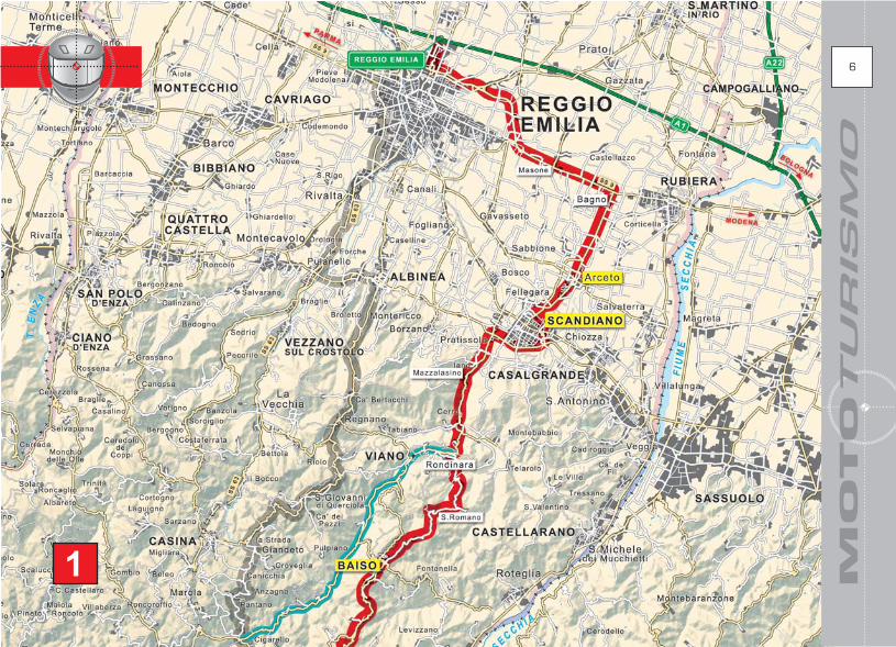
Usciti dal casello di Reggio Emilia seguite le indicazioni per “Altre direzioni” (cartelli blu) poi quelle per“Tangenziale” (cartelli verdi) e proseguite per Scandiano. Percorrerete la tangenziale prima e la SS9dopo. Questo primo tratto sulla SS9 è un po’ trafficato, soprattutto nei giorni feriali, ma non demoralizzatevi!Passerete Masone, poi Bagno dove lascerete la SS9 svoltando a destra, sempre seguendo le indicazioniper Scandiano e procedendo verso una chiesa con campanile imboccando Via Lasagni.Entrate a Scandiano (dopo poco più di 20 km dall’inizio dell’itinerario), troverete a destra le indicazionimarroni per la Rocca dei Boiardo; circa 600 m dopo il cartello bianco Scandiano (150 metri prima di unpassaggio a livello), svoltate a sinistra seguendo le indicazioni per “Tutte le direzioni - Sassuolo - SS467”(attenzione che i cartelli sono a volte poco visibili) poi, dopo circa 600 metri, ancora a sinistra per la stessaindicazione e dopo ulteriori 400 metri circa allo stop svoltate a destra seguendo l’indicazione per la SS467.Adesso seguite le indicazioni per Baiso, raggiungendo la SP7, passando Iano (zona dei vini Colli diScandiano), poi Mazzalasino e Rondinara.Lasciate la SP7 svoltando a sinistra per S. Romano – Visignolo per percorrere una stradina sperdutache si snoda nel verde e attraversa una serie di bel l issimi calanchi striat i di rosso.Seguite ancora le indicazioni per S. Romano e successivamente per Baiso. Raggiungerete Baiso, dominatadall’alto dall’omonimo castello e allo stop (c’è una chiesa alla vostra sinistra) girerete a destra già in vistadello stop successivo, a cui svolterete a sinistra in direzione di Carpineti lungo la SP7.Dopo circa 5 km raggiungerete un innesto dove lascerete la SP7 svoltando a sinistra per Valestra lungola SP64. Attraversate Valestra, appollaiata nei pressi della parete rocciosa dell’omonimo monte, eproseguite per Bebbio – Cerredolo.Dopo circa 2 km vedrete lungo la strada alla vostra destra una casa “sprofondata” da un lato a causadel cedimento del terreno e, nel caso vi interessi, la breve deviazione per la chiesetta di Casteldaldo.Circa 500 m dopo la casa “sprofondata”, svoltate a destra per Toano, scendendo verso il fiume eproseguendo poi per Cerredolo, costeggiando il fiume Secchia.Attenzione perché durante i giorni feriali in questo tratto possono esserci svariati camion in transito perla vicina cava di sabbia.Entrate a Cerredolo proseguendo in salita facendo attenzione, in quanto quasi subito dopo (circa 500metri) dovrete seguire le indicazioni per Toano, svoltando a destra lungo Via del Lago (è praticamentela SP8). Attenzione perché il cartello non è subito ben visibile essendo situato molto vicino alla stessacurva a cui dovete svoltare. Proseguite per Toano, costeggiando alcune tipiche costruzioni in sasso.Per una interessante deviazione alla chiesa di S. Michele Arcangelo svoltate a sinistra per Massa (circa8 km da quando avete svoltato a destra per Toano alla curva con il cartello poco visibile). Dopo la svolta,girate subito a destra lungo Via S. Michele Arcangelo. Troverete alla vostra sinistra l’oratorio dellaMadonna delle Grazie e, proseguendo ancora lungo la salita, raggiungerete la bella chiesa di San Michele.Se poi volete sgranchirvi un po’, potete parcheggiare e fare due passi, raggiungendo i resti della torredi un castello ormai distrutto, posta su di una piccola altura che raggiungerete in 10 minuti dalla chiesa;
10

IT
IN
ER
AR
I D
I
11
Il dolce paesaggio della collina, lungo laStrada dei Vini e dei Sapori delle Collinedi Scandiano e Canossa.Die sanfte Landschaft der Hügel, an derWein- und Spezial itätenstraße vonScandiano und Canossa ent lang.The gentle hillside landscapes along theStrada dei Vini e dei Sapori delle Colline diScandiano e Canossa.
Il colore delle argille di Visignolo di Baisodipende dalla presenza di diversi minerali.Die Färbung der Tonerde in Visignolo diBaiso stammt von den verschiedenendarin enthaltenen Mineralien.The colour of the clays in Visignolo di Baisodepends on the presence of differentminerals.
1 SCANDIANO, LAND DER DICHTER UND DENKER
vi troverete anche un’area pic-nic attrezzata.Deviazione o meno (ma è consigliata!) proseguite (o comunque ritornate) lungo la stessa strada di primae dopo circa un kilometro svoltate a destra per Manno lungo Via Montechiodo; dopo ulteriori 2 kmincontrerete un piccolo stop, dove girare a sinistra per Toano, imboccando Via Comm. Ghirardinicosteggiando il borgo di Manno. Se cercate un posto per una sosta e bere un sorso d’acqua fresca, sullato sinistro della strada c’è una fontana e una piccola area attrezzata.Proseguite per Toano poi, entrati in paese, giunti ad un bivio potrete: svoltare a destra lungo Via Matildedi Canossa così da raggiungere, percorrendo a piedi l’ultimo breve tratto in salita alla fine della strada,l’incantevole Pieve di Toano (consigliato!); altrimenti svoltate a sinistra per proseguire l’itinerario lungoVia S. Anna e allo stop in fondo ad essa proseguite svoltando a destra (non ci sono cartelli).Proseguite quindi per Quara ( indicazioni circa un kilometro dopo lo stop di Via S.Anna).Passate Quara, poi svoltate a sinistra per Gova, poi proseguite in direzione di Novellano (ma non doveteentrare in paese) e Civago (praticamente diritto lungo la stessa strada) attraversando fitti boschi efaggete. Attenzione che l ’asfalto è a tratt i un po’ sconnesso e sporco di brecciol ino.Giunti ad uno stop svoltate a sinistra per Civago percorrendo la SP9. Passerete attraverso un varcoaperto nella roccia dominato dai resti della Torre del’Amorotto, raggiungibile a piedi da un sentierinosulla sinistra, prima di entrare nella galleria (al km 32 della SP9).Prima di raggiungere Civago, nel caso vi interessi fare due passi per raggiungere un metato, teneted’occhio il cartello in legno che indica “Metati” (essiccatoi per le castagne un tempo fulcro dell’economiamontana), posto sul lato sinistra della strada. Raggiungerete il metato in 5 minuti a piedi tra i castagni.Dopo il cartello bianco Civago proseguite per Piandelagotti per la SP9 lungo un altro tratto panoramico, tratunnel di alberi, ruscelli e prati scoscesi a cavallo tra le province di Reggio Emilia e Modena lungo la SP38.L’itinerario si conclude qui dandovi la possibilità di secegliere come proseguire: verso Modena, Passodelle Radici, o la Toscana…
Nach Verlassen der Autobahn bei der Ausfahrt Reggio Emilia folgen Sie den Schildern “Altre direzioni”(blaue Schilder), dann denen “Tangenziale” (grüne Schilder) und fahren weiter Richtung Scandiano. Siefahren erst auf der Umgehungsstraße und dann auf der SS9. Auf diesem ersten Stück der SS9 gibt esvor a l lem werktags re lat i v v ie l Verkehr , aber lassen S ie s ich n icht entmut igen !Sie kommen durch Masone, dann Bagno, wo Sie die SS9 verlassen und nach rechts abbiegen, dabei folgenSie weiter der Ausschilderung nach Scandiano. Sie fahren in Richtung einer Kirche mit Kirchturm undnehmen Via Lasagni.Sie fahren nach Scandiano hinein (nach etwas mehr als 20 km vom Ausgangsort), und finden zu IhrerRechten die braunen Schilder zur Rocca dei Boiardo; etwa 600 m nach dem weißen Schild Scandiano(150 vor einem Bahnübergang) biegen Sie nach links ab und folgen den Schildern “Tutte le direzioni -Sassuolo - SS467” (Vorsicht, die Schilder sind nicht immer gut zu sehen). Nach etwa 600 Metern biegenSie erneut nach links ab, immer noch nach den genannten Richtungsanweisungen, und nach weiteren 400

MO
TO
TU
RIS
MO
Architettura t ipica in Appennino.Typische Architektur im Apennin .T y p i c a l A p e n n i n e a r c h i t e c t u r e .
Un'antichissima scultura nella pieve diMassa di Toano rappresenta la cacciatadal Paradiso Terrestre.Eine besonders alte Skulptur in der Pfarreivon Massa di Toano stellt die Vertreibungaus dem Paradies dar.An ancient sculpture in the Massa di Toanoparish church, depicting the banishmentof Adam and Eve from the Earthly Paradise.
Metern zirka biegen Sie an dem Stop-Schild nach rechts und folgen den Schildern in Richtung SS467.Jetzt folgen Sie den Schildern nach Baiso, erreichen die SP7, kommen durch Iano (Weinanbaugebiet“Colli di Scandiano”), durch Mazzalasino und Rondinara.Verlassen Sie die SP7 und biegen sie nach links ab in Richtung S. Romano – Visignolo, hier fahren sieein einsamen Sträßchen entlang, dass sich durch die grüne Landschaft windet, wobei sie durch einigewunderschöne rotgestreifte Erdfalten kommen.Fahren Sie weiter in Richtung S. Romano und dann Richtung Baiso. Sie erreichen Baiso, das von demalten, gleichnamigen Schloss beherrscht wird, und am Stop-Schild (zu Ihrer Linken befindet sich eineKirche) biegen Sie nach rechts ab, von wo aus Sie schon das nächste Stop-Schild erblicken, an dem Sienach links in Richtung Carpineti fahren, die SP7 entlang.Nach etwa 5 km erreichen Sie eine Kreuzung, wo Sie die SP7 verlassen, nach links Richtung Valestraabbiegen und die SP64 entlang fahren. Sie kommen durch Valestra, das in der Nähe der Felswand desgleichnamigen Berges liegt, und fahren weiter nach Bebbio - Cerredolo.Nach etwa 2 km sehen Sie längs der Straße zu Ihrer Rechten ein Haus, das auf der einen Seite wegeneinem Erdrutsch „versunken“ ist, und falls es Sie interessiert, können Sie von dort einen kurzen Abstecherzur Kirche Casteldaldo machen.Etwa 500 m nach dem „versunkenen“ Haus biegen Sie nach rechts nach Toano ab, fahren zum Flusshinunter und weiter Richtung Cerredolo am Fluss Secchia entlang.Vorsicht, werktags kommen hier immer wieder Lastwagen vorbei, die auf dem Weg von oder zu dernaheliegenden Sandgrube sind.Sie fahren nach Cerredolo hinein und weiter bergauf. Passen Sie auf, gleich anschließend (nach etwa500 Metern) müssen Sie der Ausschilderung nach Toano folgen. Sie biegen nach rechts ab und fahrenVia del Lago entlang (das ist praktisch die SP8). Vorsicht, das Schild ist nicht gleich gut sichtbar, weiles sehr nah an der Kurve selbst steht, an der Sie abbiegen müssen.Fahren Sie weiter Richtung Toano, sie kommen an einigen typischen Steingebäuden vorbei.Für einen interessanten Abstecher zur Kirche S. Michele Arcangelo biegen Sie nach links in Richtung Massaab (etwa 8 km nachdem Sie nach rechts in Richtung Toano abgebogen sind, in der Kurve mit den schlechtsichtbaren Schild). Nach der Abzweigung biegen Sie gleich nach rechts ab und nehmen die Via S. MicheleArcangelo. Zu Ihrer Linken sehen Sie das Oratorium Madonna delle Grazie und weiter bergauf erreichenSie die schöne Kirche San Michele. Wenn Sie sich ein bisschen die Beine vertreten möchten, können Sieparken und mit ein paar Schritten in 10 Minuten die Reste des Turmes eines inzwischen verfallenen Schlosseserreichen, die sich auf einer kleinen Anhöhe befinden. Hier gibt es auch Tische und Bänke zum Picknicken.Nach dem Abstecher oder auch ohne (er ist aber empfehlenswert!) fahren Sie auf dieselbe Straße vonvorher zurück (oder auf dieser weiter), nach etwa einem Kilometer biegen Sie nach rechts in RichtungManno ab und fahren die Via Montechiodo entlang; nach weiteren 2 km kommen Sie an ein Stop-Schild,wo Sie nach links in Richtung Toano abbiegen und die Via Comm. Ghirardini nehmen, die am DörfchenManno entlang führt. Wenn Sie eine Pause einlegen und einen Schluck Wasser trinken möchten, könnenSie sich an dem Brunnen links der Straße bedienen, wo es auch einen kleinen Rastplatz gibt.Fahren Sie weiter Richtung Toano, und im Ort, wenn Sie an eine Abzweigung gelangen, haben Sie zweiMöglichkeiten: Entweder biegen Sie nach rechts ab und nehmen Via Mathilde di Canossa, auf der Sieam Ende der Straße (ein letztes kurzes bergauf Stück ist zu Fuß zurückzulegen) die bezaubernde Pfarreivon Toano erreichen. (empfehlenswert!); oder Sie biegen nach links ab und fahren die Via S. Anna entlangbis zum Stop-Schild am Ende und von dort aus fahren Sie nach rechts weiter (es gibt keine Schilder).
12

IT
IN
ER
AR
I D
I
13
La pieve di Toano, importante chiesaromanica.Die Pfarrei von Toano, eine wichtigeromanische Kirche.Toano parish church, an importantRomanesque church.
I l percorso s i snoda per stradesecondar ie fra boschi e radure.Der Weg führt über Nebenstraßen durchWälder und Lichtungen.The route winds along minor roads,through woods and glades.
1 SCANDIANO LAND OF SCIENTISTS AND POETS
Nun fahren Sie weiter Richtung Quara (Ausschilderung etwa einen Kilometer nach dem Stop-Schild inVia S. Anna).Sie kommen durch Quara und biegen dann nach links Richtung Gova ab. Dann fahren Sie in Richtung Novellano(aber Sie dürfen nicht in den Ort hineinfahren) und Civago (der Ort liegt an derselben Straße), wobei Sie durchdichte Wälder und Buchenhaine kommen. Vorsicht, der Asphalt ist zum Teil etwas beschädigt und voller Splitt.Sie gelangen an ein Stop-Schild und biegen nach links in Richtung Civago. Hier fahren die auf der SP9 undkommen durch einen Durchgang in dem Felsen, der von den Turmruinen del’Amorotto beherrscht wirdund zu Fuß über einen Weg auf der linken Seite vor dem Tunnel (bei km 32 der SP9) zu erreichen ist.Bevor Sie Civago erreichen, können Sie mit ein paar Schritten, falls es Sie interessiert, eine Trockenanlagefür Esskastanien erreichen. Folgen Sie dem Holzschild mit Aufschrift „Metati” (Trockenanlagen fürEsskastanien standen einst im Mittelpunkt der Wirtschaft in den Bergen), das sich auf der linken Seiteder Straße befindet. In 5 Minuten zu Fuß durch einen Kastanienhain gelangen Sie zu der Anlage.Nach dem weißen Schild Civago fahren Sie weiter Richtung Piandelagotti auf der SP9. DiesePanoramastraße, später SP38, zwischen den Provinzen Reggio Emilia und Modena geleitet Sie durchdichte, hohe Wälder und an Bächen und Wiesen entlang.Die Tour endet hier und stellt die Wahl zur Weiterfahrt frei: nach Modena, zum Passo delle Radici oderin die Toskana ...
Exiting from the Reggio Emilia motorway tollbooth, follow the signs for “Altre direzioni” (“other directions”,blue signs) then those for the “Tangenziale” (“city bypass”, green signs) and head towards Scandiano.This route takes you along the city bypass first of all, then the SS9. The traffic on this first stretch ofthe SS9 is quite heavy, especially on weekdays, but don’t let this put you off!You will pass Masone, then Bagno, where you will leave the SS9 turning right, still following the signsfor Scandiano and travel l ing towards a church with a bel l tower, take Via Lasagni .In Scandiano (after little more than 20 km from the beginning of the route), you will find the brown roadsigns for Rocca dei Boiardo (Boiardo fortress) on the right. About 600 m after the white sign readingScandiano (150 metres before a level crossing) turn left following the signs for “Tutte le direzioni -Sassuolo - SS467” (be aware that the road signs are sometimes difficult to see). After approximately600 metres, turn left again at a similar sign and after another 400 metres approximately, turn rightat the stop sign following the sign for the SS467.Now follow the signs for Baiso to the SP7, passing Iano (area producing the “Colli di Scandiano” wines),then Mazzalasino and Rondinara.Leave the SP7 turning left to S. Romano - Visignolo along a small isolated road winding through thegreen countryside and crossing a series of beautiful red-streaked calanques.Keep following the signs for S. Romano and then for Baiso. In Baiso, dominated from above by a castleof the same name, turn right at the stop sign (there is a church on your left) where the following stopsign can already be seen. Turn left here towards Carpineti , travel l ing along the SP7.

MO
TO
TU
RIS
MO
Spesso in montagna le mucche sonoportate al pascolo. I motociclisti devonofare attenzione.Im Gebirge werden die Kühe oft auf dieWeide geführt. Motorradfahrer müssenaufpassen.In the mountains, cattle are often takento pasture. Take extra care.
Ci si avvicina al crinale.Der Geb irgskamm kommt näher .Approaching the ridge.
After about 5 km you will reach a junction where you will leave the SP7 turning left for Valestra alongthe SP64. Go through Valestra, perched near the rocky walls of the mountain of the same name, andcarry on towards Bebbio – Cerredolo.After approximately 2 km, you will see a house on your right, “sunken” on one side due to subsidence.There is also a short detour to the little church of Casteldaldo should this interest you.About 500 m after the “sunken” house, turn right for Toano, descending towards the river and followingthe road to Cerredolo along the banks of the river Secchia.Be aware that on weekdays the road can get very busy with lorries due to the nearby sand quarry.In Cerredolo follow the road uphill. Proceed with care as you should turn almost immediately afterwards(approximately 500 metres) following the signs for Toano, turning right along Via del Lago (it is practicallythe SP8). Take care however as the sign is not immediately visible as it is very near to the same bendyou should turn in to. Carry on towards Toano, passing several typical stone buildings.For an interesting detour to the church of S. Michele Arcangelo turn left for Massa (approximately 8km from the right turn to Toano on the bend with the barely visible road sign). After the turn, turn rightimmediately along Via S. Michele Arcangelo. On your left you will find the oratory of the Madonna delleGrazie and, carrying on uphill you will reach the beautiful church of San Michele. If you feel like stretchingyour legs a little, you can park and take a stroll to the ruins of a castle tower set on a small rise, tenminutes walk from the church. There is also a well-equipped picnic area.Whether or not you choose the detour (however it is highly recommended!), follow (or go back along)the same road as before and after approximately one kilometre turn right for Manno along Via Montechiodo.After a further 2 km you will find a small stop sign – turn left here for Toano along Via Comm. Ghirardinipassing the village of Manno. If you are looking for a place to stop for a drink of fresh water, there is afounta in and a smal l we l l -equ ipped rest area on the le f t hand s ide of the road.Keep following the road to Toano. At a fork in the road in the town you can turn right along Via Matildedi Canossa. Walking the last short uphill stretch at the end of the road takes you to the enchanting Pievedi Toano (Toano parish church, highly recommended!). Otherwise turn left and follow the route along ViaS. Anna. Turn right at the stop sign at the end of the road (there are no road signs).Follow the road for Quara (signs begin about one kilometre after the stop sign in Via S.Anna).Pass Quara then turn left for Gova. Carry on towards Novellano (but do not go into the town) and Civago(practically straight along the same road) passing through thick forests and beech woods. Take care asthe asphalt is a little broken up in parts and covered in gravel.At a stop sign, turn left for Civago along the SP9. You will pass through an open passage in the rockdominated by the ruins of the tower Torre del’Amorotto, which can be reached on foot from a path onthe left before entering the tunnel (32 km from the SP9).Before reaching Civago, should you wish to take a stroll to a “metato” (drying houses for chestnuts, oncethe hub of the mountain economy), keep an eye out for the wooden sign reading “Metati”on the left-handside of the road. The building can be reached with a five-minute walk among the chestnut trees.After the white sign for Civago, follow the SP9 towards Piandelagotti along another panoramic stretch,between tunnels of trees, streams and steep meadows between the provinces of Reggio Emilia andModena along the SP38.The route ends here, leaving you free to decide how to continue, towards Modena, Passo delle Radici,or Tuscany…
14