Embed Size (px)
Citation preview
Ave U
Ave V Lomb Ave
Ave V
43rd S
t
Warrior Road
Fairgrounds Dr
30th St
Ave T
28th St
Ave S
17th
St W
16th Pl SW
30th St
Faye
tte A
ve
Borde
r St
30th St Cu
llman
Ave
46th Pl
29th S
t
Faye
tte A
ve
48th Pl
Monroe Ave
47th St
Ave X
Ave R
Ave R
31st St
Ave S
32nd St
1st Ave W
48th St
Ave W
29th P
l
34th St
30th P
l
27th St
19th
St SW
Ave S
Ct S
Ave T
Ensley-Five Points West Ave
Ave V
Ave T
Ave T
31st St
Ct V
Fulton Ave
Faye
tte A
ve
27th St
47th Pl
31st St 31st St
Ave Y
Ter R
Ct R
Warrior Road
17th
St SW
Ave X
Alabama Ave
Lomb Ave W
27th St
Ave V
Woodland AveBess
emer R
oad
1st Ct W
47th St28t
h St
28th St
30th S
t
Ave W
35th St
30th St
Ave W
Warrior Road
Ter S
Ave R
18th
St SW
28th St
Ensley-Five Points West Ave
29th St
Cullm
an Av
e
Ct S
Ter S
Madison Ave
Madison A
ve
30th St
30th St
29th St
Annis
ton Av
e
Bessemer R
oad
18thSt SW
Warrior R
oad
Ave Z
Prince Ave31s
t St
Ave W
33rd St
18th
Pl SW
Ct X
Madison Ave
Ave S
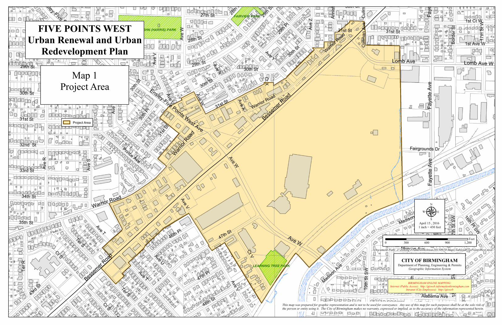
MCMAHON, JOHN (HARRIS) PARK
LEARNING TREE PARK
FAIRVIEW PARK
FIVE POINTS WESTUrban Renewal and Urban
Redevelopment Plan
BIRMINGHAM ONLINE MAPPING:Internet (Public Access): http://gisweb.informationbirmingham.com
Intranet (City Employees): http://gisweb
This map was prepared for graphic representation and is not to be used for conveyance. Any use of this map for such purposes shall be at the sole risk ofthe person or entity using it. The City of Birmingham makes no warranty, expressed or implied, as to the accuracy of the information represented herein.
CITY OF BIRMINGHAMDepartment of Planning, Engineering & Permits
Geographic Information System
µ April 15 , 20161 inch = 430 feet
0 300 600 900 1,200Feet
Document Path: J:\Zoning\FrameworkAreas20150910\Maps\TabloidFivePointsWest.mxd
Map 1Project Area
Project Area
![G' - nikkankeiba.co.jp · ]AA ©+ @?? ©u s s s s s s s s t m m s P · · + n s m 3 ! s " G G E F s s s s s · · H H H H H t tk Km KL Kb n r n m n r n { t Z b MH r s n m t m s s](https://img.pdfslide.tips/doc/110x75/5e5582d830d9767356171f2e/g-aa-u-s-s-s-s-s-s-s-s-t-m-m-s-p-n-s-m-3-s-g-g-e-f-s-s.jpg)