Embed Size (px)
Citation preview
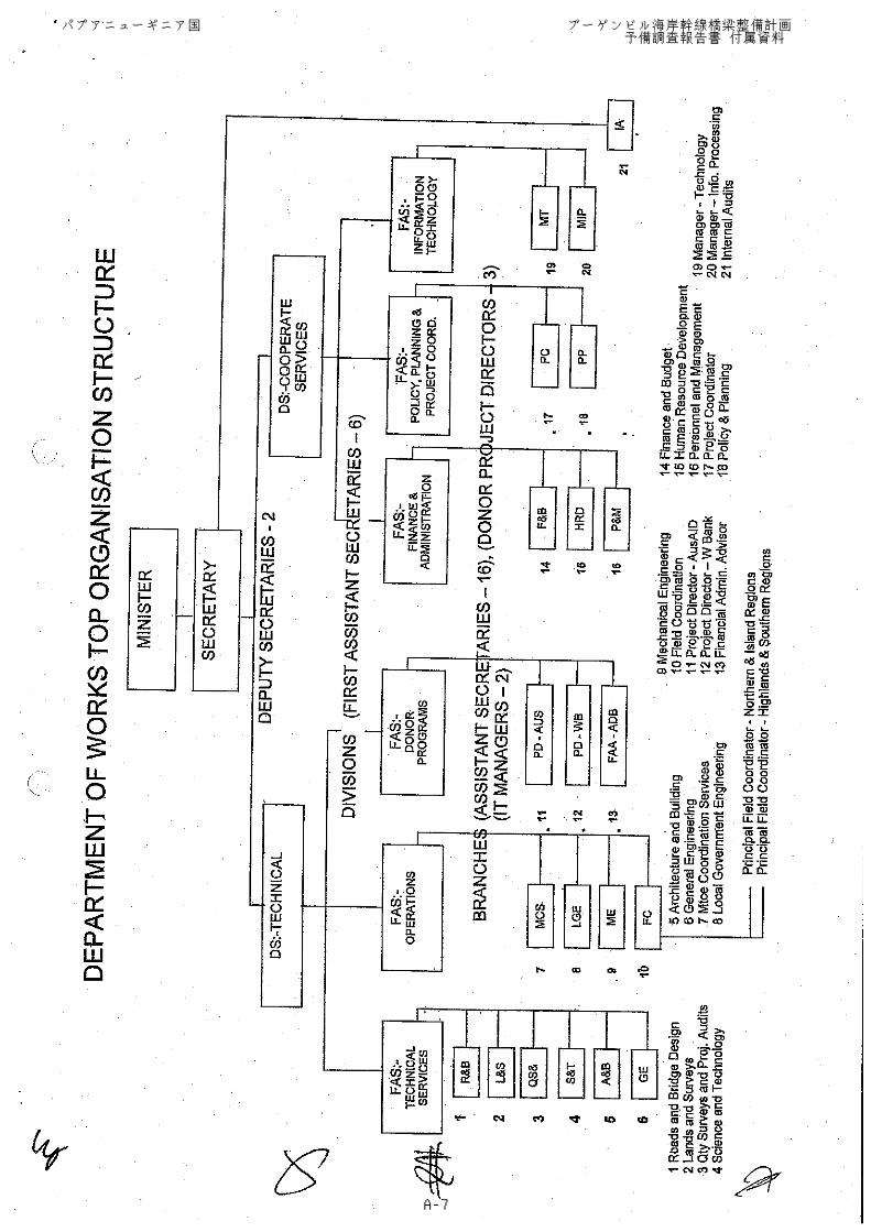
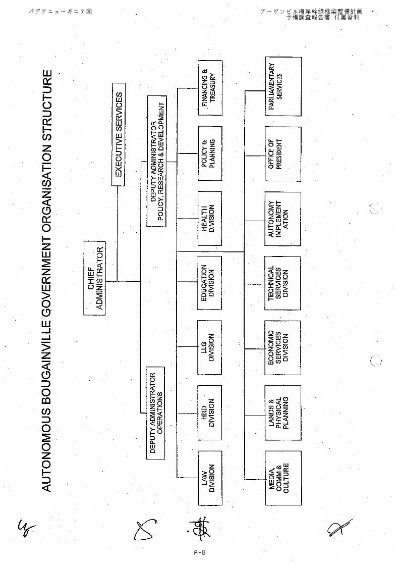
パプアニューギニア国 ブーゲンビル海岸幹線橋梁整備計画 予備調査報告書 付属資料
A-1
付属資料(1) 署名ミニッツ
パプアニューギニア国 ブーゲンビル海岸幹線橋梁整備計画 予備調査報告書 付属資料
A-2
パプアニューギニア国 ブーゲンビル海岸幹線橋梁整備計画 予備調査報告書 付属資料
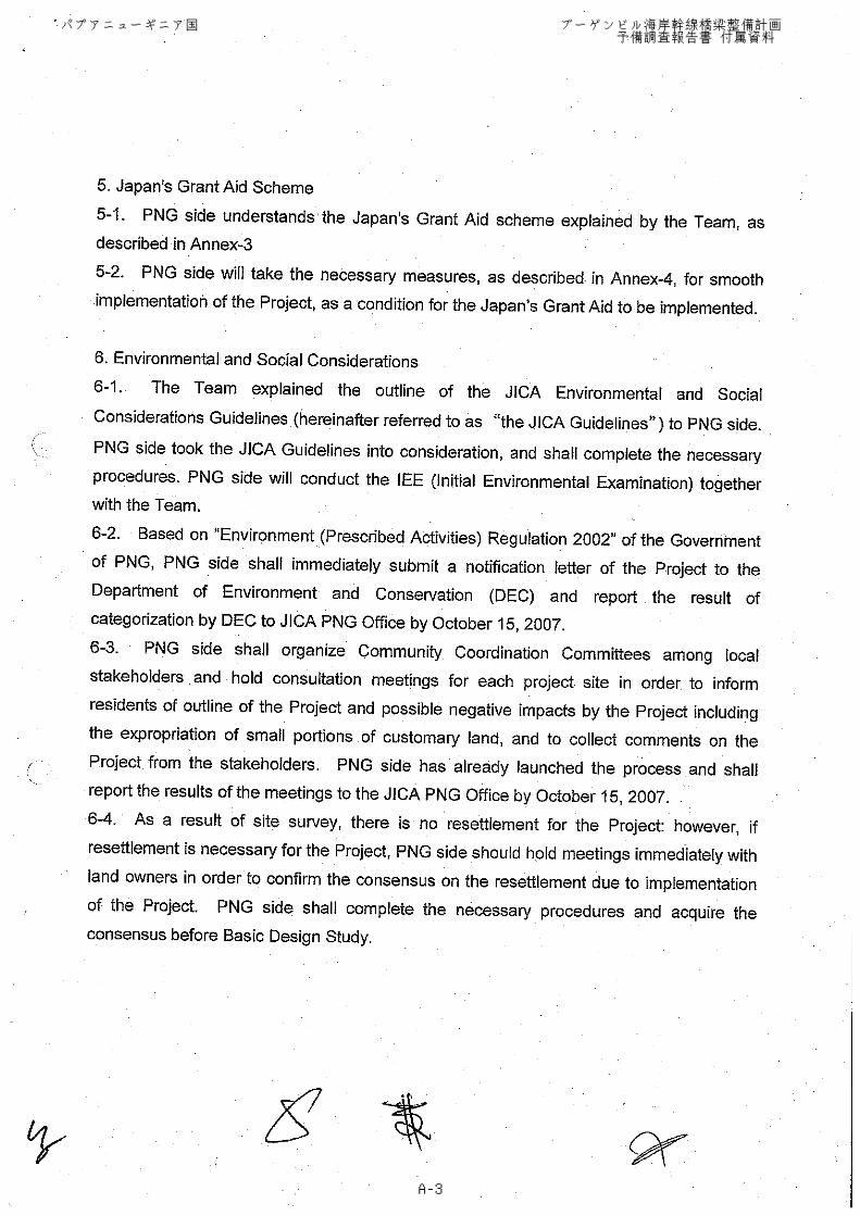
A-3
パプアニューギニア国 ブーゲンビル海岸幹線橋梁整備計画 予備調査報告書 付属資料
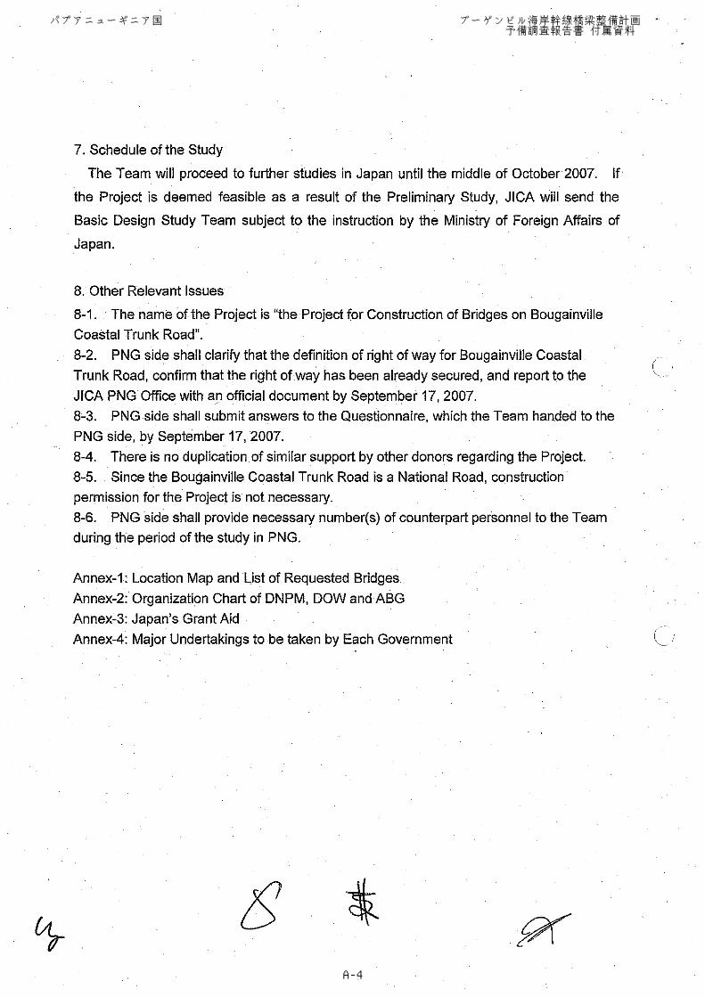
A-4
パプアニューギニア国 ブーゲンビル海岸幹線橋梁整備計画 予備調査報告書 付属資料
A-5
パプアニューギニア国 ブーゲンビル海岸幹線橋梁整備計画 予備調査報告書 付属資料
A-6
パプアニューギニア国 ブーゲンビル海岸幹線橋梁整備計画 予備調査報告書 付属資料
A-7
パプアニューギニア国 ブーゲンビル海岸幹線橋梁整備計画 予備調査報告書 付属資料
A-8
パプアニューギニア国 ブーゲンビル海岸幹線橋梁整備計画 予備調査報告書 付属資料
A-9
パプアニューギニア国 ブーゲンビル海岸幹線橋梁整備計画 予備調査報告書 付属資料
A-10
パプアニューギニア国 ブーゲンビル海岸幹線橋梁整備計画 予備調査報告書 付属資料
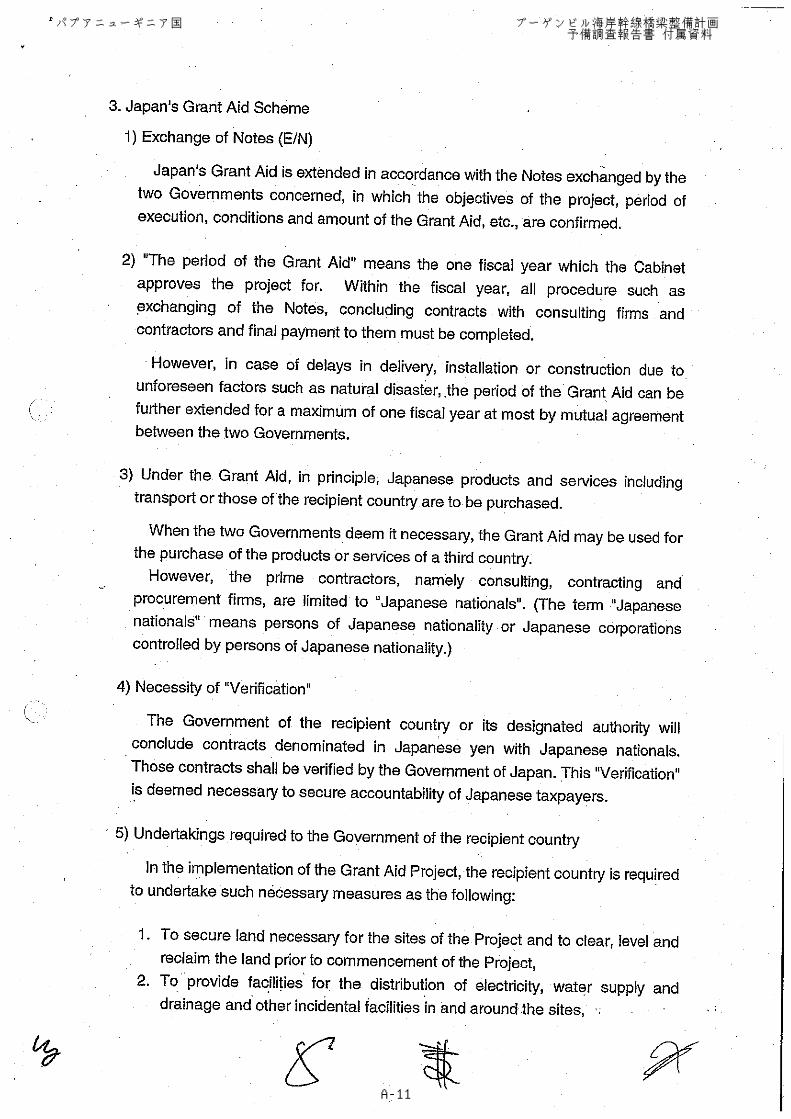
A-11
パプアニューギニア国 ブーゲンビル海岸幹線橋梁整備計画 予備調査報告書 付属資料
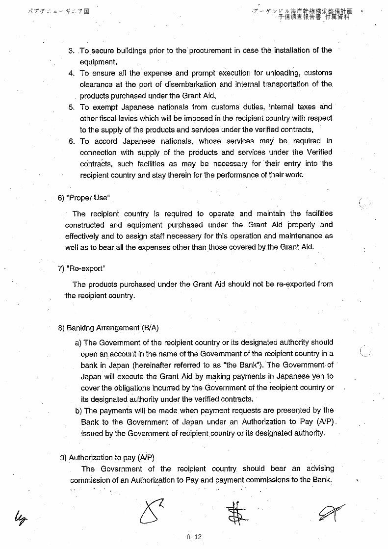
A-12
パプアニューギニア国 ブーゲンビル海岸幹線橋梁整備計画 予備調査報告書 付属資料
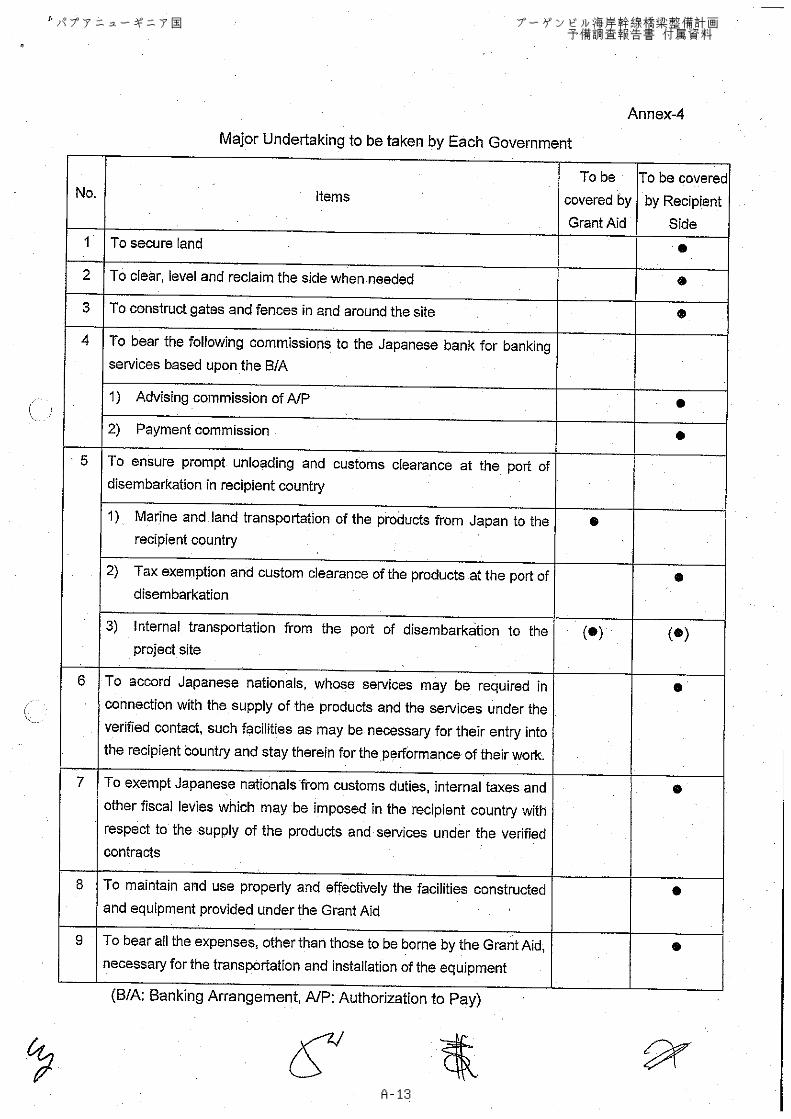
A-13
Buka
Arawa
Papua New Guinea
Bougainville Island
ソロモン国
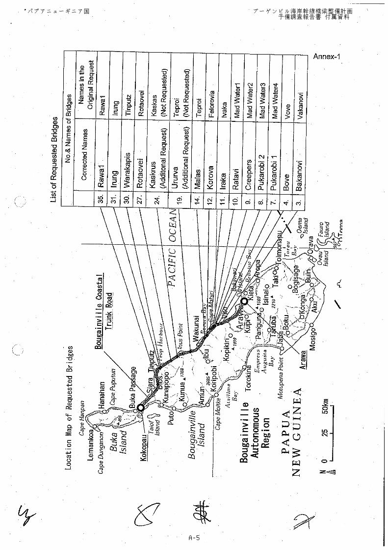
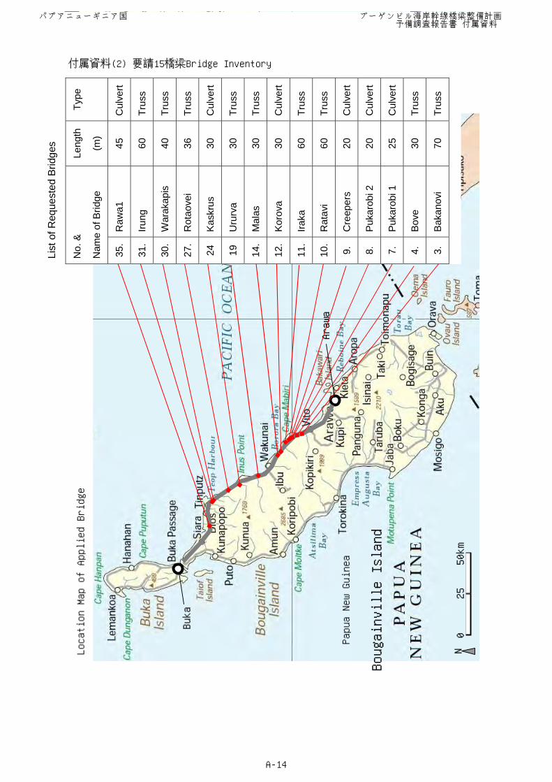
Location Map of Applied Bridge
List
of R
eque
sted
Brid
ges
No.
&
Nam
e of
Brid
ge
Leng
th
(m)
Type
35.
Raw
a1
45
Cul
vert
31.
Irung
60
Tr
uss
30.
War
akap
is
40
Trus
s
27.
Rot
aove
i 36
Tr
uss
24
Kas
krus
30
C
ulve
rt
19
Uru
rva
30
Trus
s
14.
Mal
as
30
Trus
s
12.
Kor
ova
30
Cul
vert
11.
Iraka
60
Tr
uss
10.
Rat
avi
60
Trus
s
9.
Cre
eper
s 20
C
ulve
rt
8.
Puk
arob
i 2
20
Cul
vert
7.
Puk
arob
i 1
25
Cul
vert
4.
Bov
e 30
Tr
uss
3.
Bak
anov
i 70
Tr
uss
0 25 50km
N
パプアニューギニア国 ブーゲンビル海岸幹線橋梁整備計画 予備調査報告書 付属資料
A-14
付属資料(2) 要請15橋梁Bridge Inventory
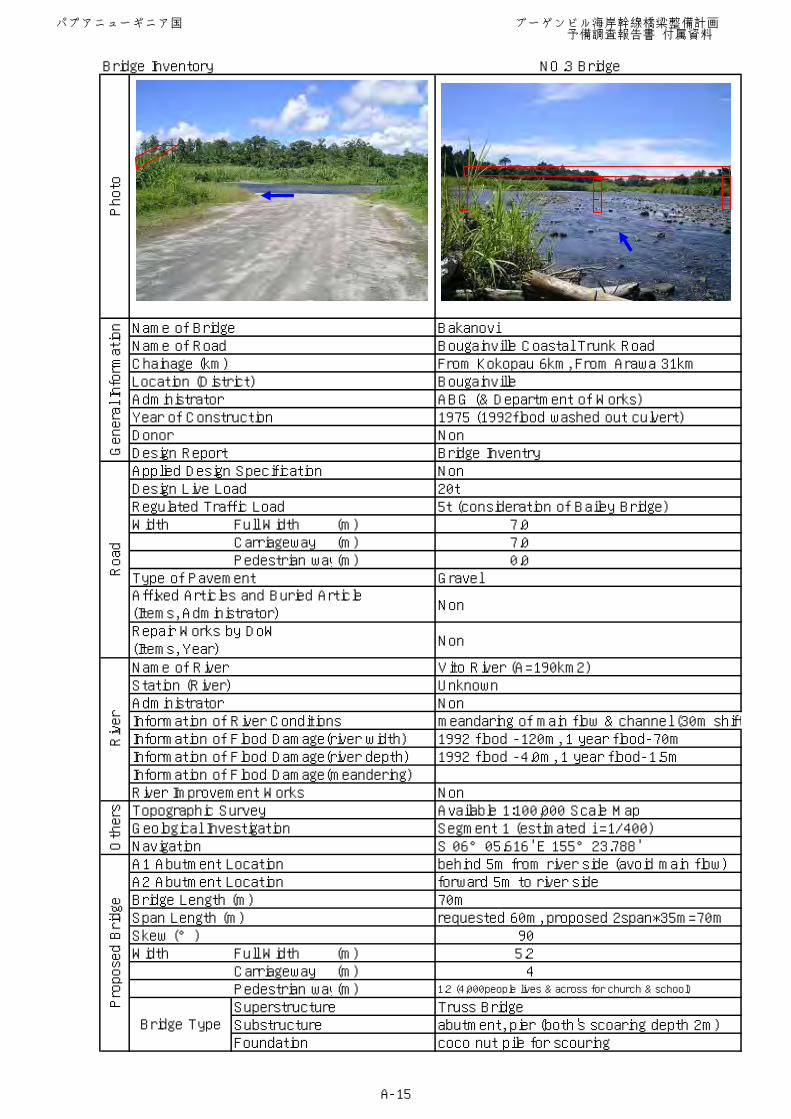
Bridge Inventory NO.3 Bridge
Name of Bridge BakanoviName of Road Bougainville Coastal Trunk RoadChainage (km) From Kokopau 6km, From Arawa 31kmLocation (District) BougainvilleAdministrator ABG (& Department of Works)Year of Construction 1975 (1992flood washed out culvert)Donor NonDesign Report Bridge InventryApplied Design Specification NonDesign Live Load 20tRegulated Traffic Load 5t (consideration of Bailey Bridge)Width Full Width (m) 7.0
Carriageway (m) 7.0Pedestrian way(m) 0.0
Type of Pavement Gravel
Non
Non
Name of River Vito River (A=190km2)Station (River) UnknownAdministrator NonInformation of River Conditions meandaring of main flow & channel (30m shiftInformation of Flood Damage(river width) 1992 flood -120m, 1 year flood-70mInformation of Flood Damage(river depth) 1992 flood -4.0m, 1 year flood-1.5mInformation of Flood Damage(meandering)River Improvement Works NonTopographic Survey Available 1:100,000 Scale MapGeological Investigation Segment 1 (estimated i =1/400)Navigation S 06°05.616' E 155°23.788'A1 Abutment Location behind 5m from river side (avoid main flow)A2 Abutment Location forward 5m to river sideBridge Length (m) 70mSpan Length (m) requested 60m, proposed 2span*35m=70mSkew (°) 90Width Full Width (m) 5.2
Carriageway (m) 4Pedestrian way(m) 1.2 (4,000people lives & across for church & school)
Superstructure Truss BridgeSubstructure abutment, pier (both's scoaring depth 2m)Foundation coco nut pile for scouring
Photo
General Information
Affixed Articles and Buried Article(Items, Administrator)
Bridge Type
Proposed Bridge
Repair Works by DoW(Items, Year)
Road
Others
River
パプアニューギニア国 ブーゲンビル海岸幹線橋梁整備計画 予備調査報告書 付属資料
A-15
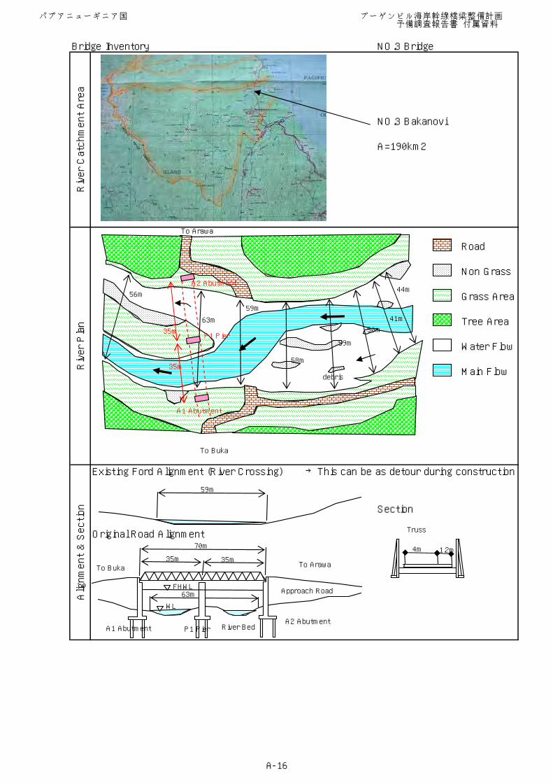
Bridge Inventory NO.3 Bridge
NO.3 Bakanovi
A=190km2
Existing Ford Alignment (River Crossing) →This can be as detour during construction
Section
Original Road Alignment
River Catchment Area
River Plan
Alignment & Section
Road
Non Grass
Grass Area
Tree Area
Water Flow
44m
41m
50m
59m
58m
Main Flow
To Buka
To Arawa
59m
63m
56m
35m
35m
A1 Abutment
A2 Abutment
P1 Pier
debris
59m
63mFHWL
WL
River Bed
Approach Road
70m
35m 35m
Truss
4m 1.2m
A1 AbutmentA2 Abutment
P1 Pier
To Buka To Arawa
パプアニューギニア国 ブーゲンビル海岸幹線橋梁整備計画 予備調査報告書 付属資料
A-16
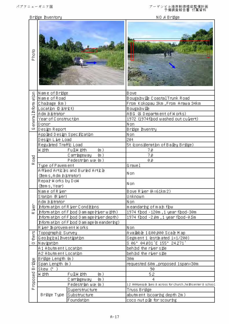
Bridge Inventory NO.4 Bridge
Name of Bridge BoveName of Road Bougainville Coastal Trunk RoadChainage (km) From Kokopau 3km, From Arawa 34kmLocation (District) BougainvilleAdministrator ABG (& Department of Works)Year of Construction 1972 (1974flood washed out culvert)Donor NonDesign Report Bridge InventryApplied Design Specification NonDesign Live Load 20tRegulated Traffic Load 5t (consideration of Bailey Bridge)Width Full Width (m) 7.0
Carriageway (m) 7.0Pedestrian way(m) 0.0
Type of Pavement Gravel
Non
Non
Name of River Bove River (A=61km2)Station (River) UnknownAdministrator NonInformation of River Conditions meandaring of main flow Information of Flood Damage(river width) 1974 flood -120m, 1 year flood-30mInformation of Flood Damage(river depth) 1974 flood -2.0m, 1 year flood-0.5mInformation of Flood Damage(meandering)River Improvement Works NonTopographic Survey Available 1:100,000 Scale MapGeological Investigation Segment 1 (estimated i =1/200)Navigation S 06°04.031' E 155°24.271'A1 Abutment Location behind the river sideA2 Abutment Location behind the river sideBridge Length (m) 30mSpan Length (m) requested 60m, proposed 1span=30mSkew (°) 90Width Full Width (m) 5.2
Carriageway (m) 4Pedestrian way(m) 1.2 (400people lives & across for church, helthcenter & school)
Superstructure Truss BridgeSubstructure abutment (scoaring depth 2m)Foundation coco nut pile for scouring
Photo
General Information
Affixed Articles and Buried Article(Items, Administrator)
Bridge Type
Proposed Bridge
Repair Works by DoW(Items, Year)
Road
Others
River
パプアニューギニア国 ブーゲンビル海岸幹線橋梁整備計画 予備調査報告書 付属資料
A-17

Bridge Inventory NO.4 Bridge
NO.4 Bove
A=61km2
Existing Road Alignment Section
Alignment & Section
River Catchment Area
River Plan
Road
Non Grass
Grass Area
Tree Area
Water Flow
Main Flow
To Buka
To Arawa
FHWL
WL
River Bed
Approach Road
30m
10m
20m
5m
7m5m
22m26m
27m14m
7m6m8m
A2 Abutment
A1 Abutment
30m
Truss
4m 1.2m
A1 AbutmentA2 Abutment
To Buka To Arawa
パプアニューギニア国 ブーゲンビル海岸幹線橋梁整備計画 予備調査報告書 付属資料
A-18
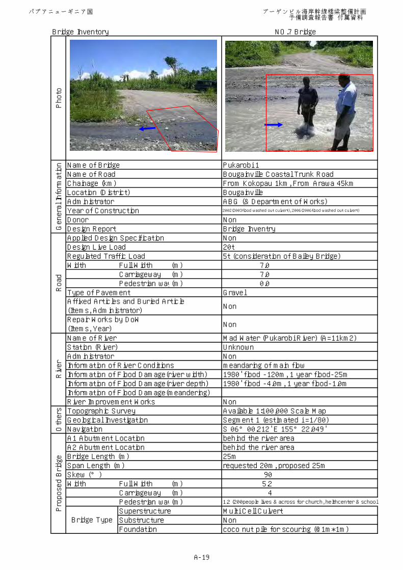
Bridge Inventory NO.7 Bridge
Name of Bridge Pukarobi 1Name of Road Bougainville Coastal Trunk RoadChainage (km) From Kokopau 1km, From Arawa 45kmLocation (District) BougainvilleAdministrator ABG (& Department of Works)Year of Construction 2002(2003flood washed out culvert), 2006(2006flood washed out culvert)
Donor NonDesign Report Bridge InventryApplied Design Specification NonDesign Live Load 20tRegulated Traffic Load 5t (consideration of Bailey Bridge)Width Full Width (m) 7.0
Carriageway (m) 7.0Pedestrian way(m) 0.0
Type of Pavement Gravel
Non
Non
Name of River Mad Water (Pukarobi River) (A=11km2)Station (River) UnknownAdministrator NonInformation of River Conditions meandaring of main flow Information of Flood Damage(river width) 1980' flood -120m, 1 year flood-25mInformation of Flood Damage(river depth) 1980' flood -4.0m, 1 year flood-1.0mInformation of Flood Damage(meandering)River Improvement Works NonTopographic Survey Available 1:100,000 Scale MapGeological Investigation Segment 1 (estimated i =1/80)Navigation S 06°00.212' E 155°22.049'A1 Abutment Location behind the river areaA2 Abutment Location behind the river areaBridge Length (m) 25mSpan Length (m) requested 20m, proposed 25mSkew (°) 90Width Full Width (m) 5.2
Carriageway (m) 4Pedestrian way(m) 1.2 (200people lives & across for church, helthcenter & school)
Superstructure Multi Cell CulvertSubstructure NonFoundation coco nut pile for scouring (@1m*1m)
Photo
General Information
Affixed Articles and Buried Article(Items, Administrator)
Bridge Type
Proposed Bridge
Repair Works by DoW(Items, Year)
Road
Others
River
パプアニューギニア国 ブーゲンビル海岸幹線橋梁整備計画 予備調査報告書 付属資料
A-19
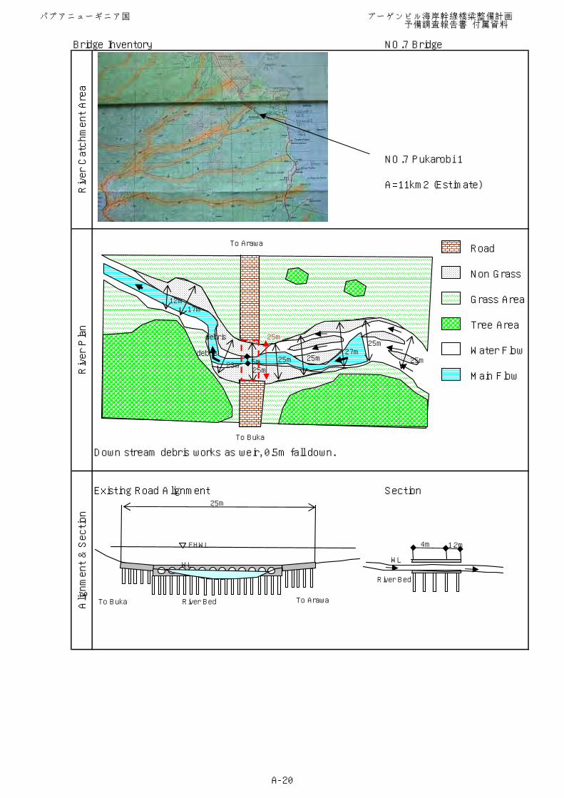
Bridge Inventory NO.7 Bridge
NO.7 Pukarobi 1
A=11km2 (Estimate)
Down stream debris works as weir, 0.5m fall down.
Existing Road Alignment Section
Alignment & Section
River Catchment Area
River Plan
Road
Non Grass
Grass Area
Tree Area
Water Flow
Main Flow
To Buka
To Arawa
FHWL
River Bed
25m
4m 1.2m
WL
River Bed
WL
25m
25m27m
25m5m 25m
25m23m
17m12m
25mdebris
debris
To Buka To Arawa
パプアニューギニア国 ブーゲンビル海岸幹線橋梁整備計画 予備調査報告書 付属資料
A-20
Bridge Inventory NO.8 Bridge
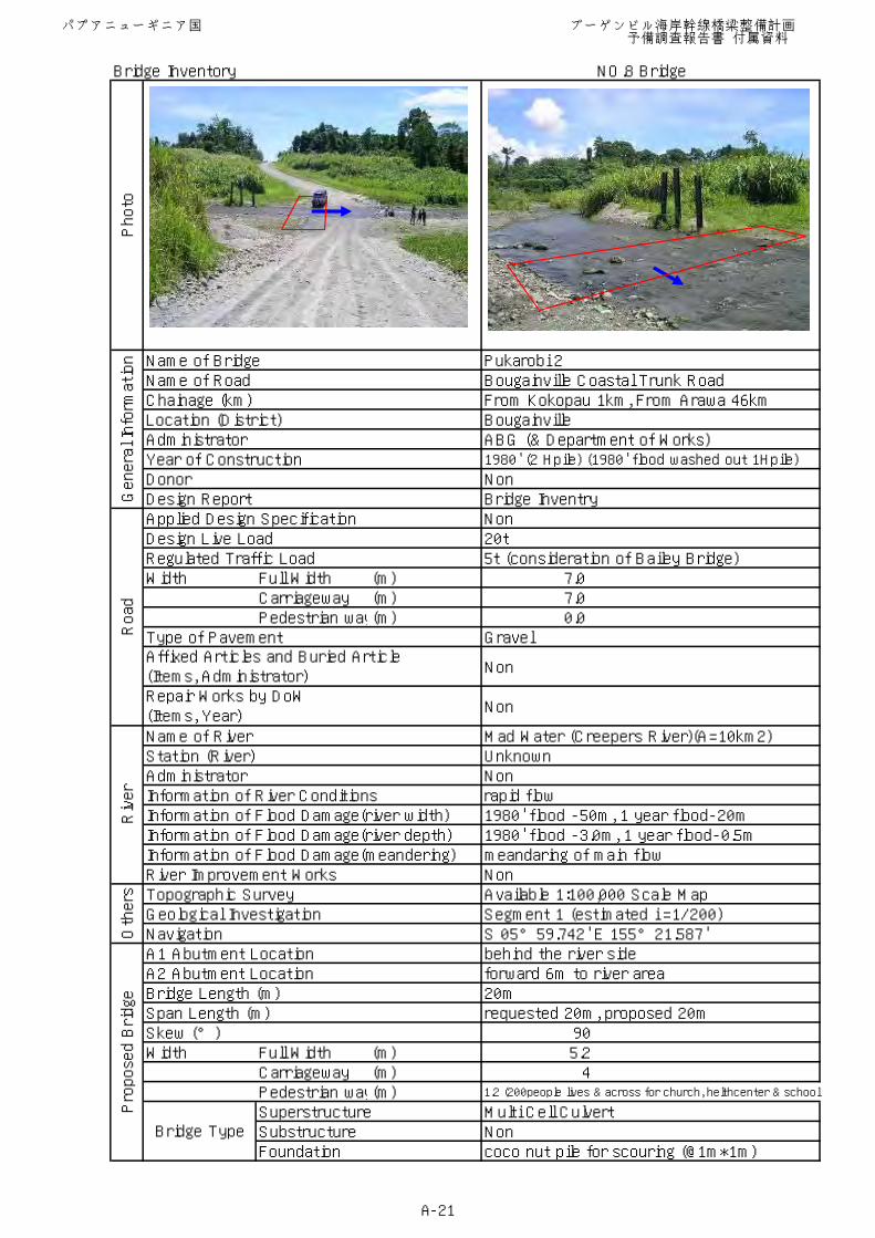
Name of Bridge Pukarobi 2Name of Road Bougainville Coastal Trunk RoadChainage (km) From Kokopau 1km, From Arawa 46kmLocation (District) BougainvilleAdministrator ABG (& Department of Works)Year of Construction 1980' (2 Hpile) (1980' flood washed out 1Hpile)
Donor NonDesign Report Bridge InventryApplied Design Specification NonDesign Live Load 20tRegulated Traffic Load 5t (consideration of Bailey Bridge)Width Full Width (m) 7.0
Carriageway (m) 7.0Pedestrian way(m) 0.0
Type of Pavement Gravel
Non
Non
Name of River Mad Water (Creepers River)(A=10km2)Station (River) UnknownAdministrator NonInformation of River Conditions rapid flowInformation of Flood Damage(river width) 1980' flood -50m, 1 year flood-20mInformation of Flood Damage(river depth) 1980' flood -3.0m, 1 year flood-0.5mInformation of Flood Damage(meandering) meandaring of main flow River Improvement Works NonTopographic Survey Available 1:100,000 Scale MapGeological Investigation Segment 1 (estimated i =1/200)Navigation S 05°59.742' E 155°21.587'A1 Abutment Location behind the river sideA2 Abutment Location forward 6m to river areaBridge Length (m) 20mSpan Length (m) requested 20m, proposed 20m Skew (°) 90Width Full Width (m) 5.2
Carriageway (m) 4Pedestrian way(m) 1.2 (200people lives & across for church, helthcenter & school)
Superstructure Multi Cell CulvertSubstructure NonFoundation coco nut pile for scouring (@1m*1m)
Photo
General Information
Affixed Articles and Buried Article(Items, Administrator)
Bridge Type
Proposed Bridge
Repair Works by DoW(Items, Year)
Road
Others
River
パプアニューギニア国 ブーゲンビル海岸幹線橋梁整備計画 予備調査報告書 付属資料
A-21
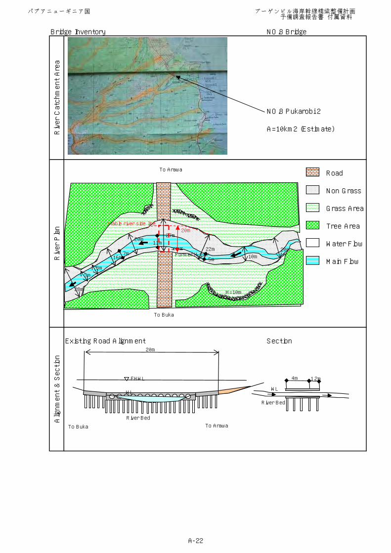
Bridge Inventory NO.8 Bridge
NO.8 Pukarobi 2
A=10km2 (Estimate)
Existing Road Alignment Section
Alignment & Section
River Catchment Area
River Plan
Road
Non Grass
Grass Area
Tree Area
Water Flow
Main Flow
To Buka
To Arawa
FHWL
River Bed
20m
4m 1.2m
WL
River Bed
WL
H=10m
Former H pier20m
10m
22m
5m
27m20m
16m
8m
9m
28m
11m
7m
To Buka
20mstable river side line
To Buka To Arawa
パプアニューギニア国 ブーゲンビル海岸幹線橋梁整備計画 予備調査報告書 付属資料
A-22
Bridge Inventory NO.9 Bridge
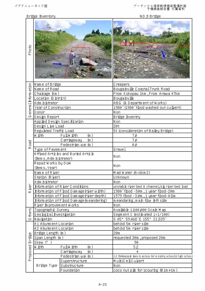
Name of Bridge Creepers Name of Road Bougainville Coastal Trunk RoadChainage (km) From Kokopau 1km, From Arawa 47kmLocation (District) BougainvilleAdministrator ABG (& Department of Works)Year of Construction 1980' (1980' flood washed out cullvert)Donor NonDesign Report Bridge InventryApplied Design Specification NonDesign Live Load 20tRegulated Traffic Load 5t (consideration of Bailey Bridge)Width Full Width (m) 7.0
Carriageway (m) 7.0Pedestrian way(m) 0.0
Type of Pavement Gravel
Non
Non
Name of River Mad Water (A=6km2)Station (River) UnknownAdministrator NonInformation of River Conditions unstable river bed & channel, big river bed load
Information of Flood Damage(river width) 1980' flood -50m, 1 year flood-20mInformation of Flood Damage(river depth) 1979 flood -3.0m, 1 year flood-0.5mInformation of Flood Damage(meandering) meandaring, main flow left sideRiver Improvement Works NonTopographic Survey Available 1:100,000 Scale MapGeological Investigation Segment 1 (estimated i =1/100)Navigation S 05°59.468' E 155°21.539'A1 Abutment Location behind 5m river sideA2 Abutment Location behind 5m river sideBridge Length (m) 20mSpan Length (m) requested 30m, proposed 20mSkew (°) 90Width Full Width (m) 5.2
Carriageway (m) 4Pedestrian way(m) 1.2 (500people lives & across for ministry school & high school
Superstructure Multi Cell CulvertSubstructure NonFoundation coco nut pile for scouring (@1m*1m)
Photo
General Information
Affixed Articles and Buried Article(Items, Administrator)
Bridge Type
Proposed Bridge
Repair Works by DoW(Items, Year)
Road
Others
River
パプアニューギニア国 ブーゲンビル海岸幹線橋梁整備計画 予備調査報告書 付属資料
A-23
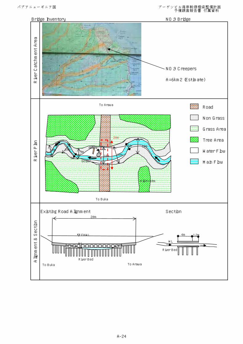
Bridge Inventory NO.9 Bridge
NO.9 Creepers
A=6km2 (Estimate)
Existing Road Alignment Section
Alignment & Section
River Catchment Area
River Plan
Road
Non Grass
Grass Area
Tree Area
Water Flow
Main Flow
To Arawa
FHWL
River Bed
20m
4m 1.2m
WL
River Bed
WL
To Buka
Hill H=10m
10m
10m10m
10m10m9m
debris
bolder3m
6m
20m
To Buka To Arawa
パプアニューギニア国 ブーゲンビル海岸幹線橋梁整備計画 予備調査報告書 付属資料
A-24
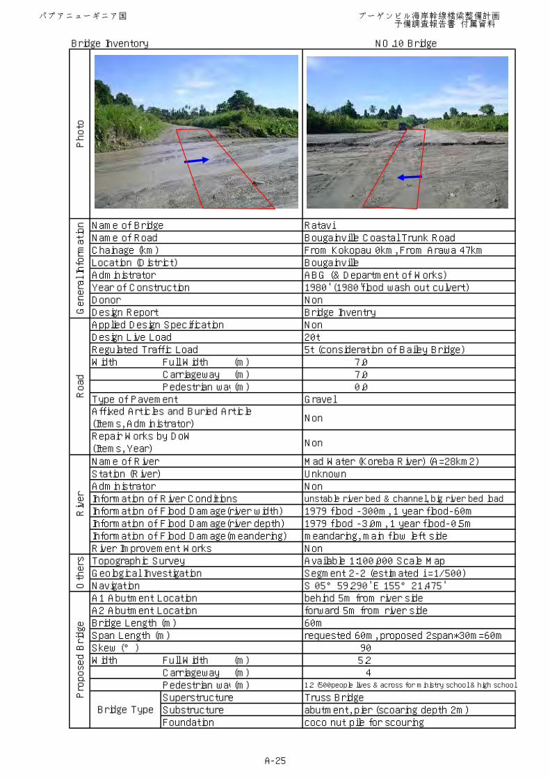
Bridge Inventory NO.10 Bridge
Name of Bridge RataviName of Road Bougainville Coastal Trunk RoadChainage (km) From Kokopau 0km, From Arawa 47kmLocation (District) BougainvilleAdministrator ABG (& Department of Works)Year of Construction 1980' (1980'flood wash out culvert)Donor NonDesign Report Bridge InventryApplied Design Specification NonDesign Live Load 20tRegulated Traffic Load 5t (consideration of Bailey Bridge)Width Full Width (m) 7.0
Carriageway (m) 7.0Pedestrian way(m) 0.0
Type of Pavement Gravel
Non
Non
Name of River Mad Water (Koreba River) (A=28km2)Station (River) UnknownAdministrator NonInformation of River Conditions unstable river bed & channel, big river bed load
Information of Flood Damage(river width) 1979 flood -300m, 1 year flood-60mInformation of Flood Damage(river depth) 1979 flood -3.0m, 1 year flood-0.5mInformation of Flood Damage(meandering) meandaring, main flow left sideRiver Improvement Works NonTopographic Survey Available 1:100,000 Scale MapGeological Investigation Segment 2-2 (estimated i =1/500)Navigation S 05°59.290' E 155°21.475'A1 Abutment Location behind 5m from river sideA2 Abutment Location forward 5m from river sideBridge Length (m) 60mSpan Length (m) requested 60m, proposed 2span*30m=60mSkew (°) 90Width Full Width (m) 5.2
Carriageway (m) 4Pedestrian way(m) 1.2 (500people lives & across for ministry school & high school
Superstructure Truss BridgeSubstructure abutment, pier (scoaring depth 2m)Foundation coco nut pile for scouring
Photo
General Information
Affixed Articles and Buried Article(Items, Administrator)
Bridge Type
Proposed Bridge
Repair Works by DoW(Items, Year)
Road
Others
River
パプアニューギニア国 ブーゲンビル海岸幹線橋梁整備計画 予備調査報告書 付属資料
A-25
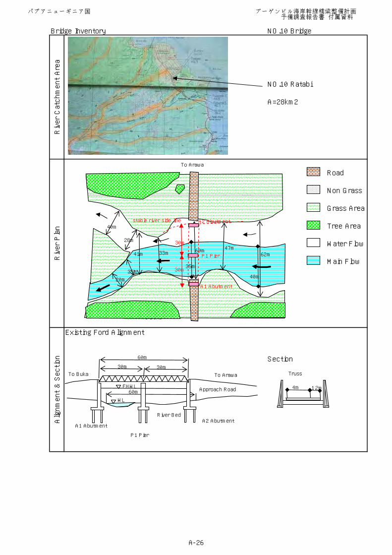
Bridge Inventory NO.10 Bridge
NO.10 Ratabi
A=28km2
Existing Ford Alignment
Section
Alignment & Section
River Catchment Area
River Plan
Road
Non Grass
Grass Area
Tree Area
Water Flow
Main Flow
To Buka
To Arawa
60mFHWL
WL
River Bed
Approach Road
60m
30m 30mTruss
4m 1.2m
62m47m60m33m41m
40m
20m
35m
40m25m
28m
A2 Abutment
P1 Pier
A1 Abutment
stable river side line
30m
30m
A1 AbutmentA2 Abutment
P1 Pier
To Buka To Arawa
パプアニューギニア国 ブーゲンビル海岸幹線橋梁整備計画 予備調査報告書 付属資料
A-26
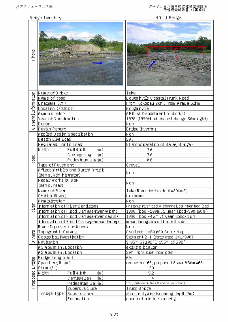
Bridge Inventory NO.11 Bridge
Name of Bridge IrakaName of Road Bougainville Coastal Trunk RoadChainage (km) From Kokopau 2km, From Arawa 52kmLocation (District) BougainvilleAdministrator ABG (& Department of Works)Year of Construction 1978 (1990flood chanel change 50m right)Donor NonDesign Report Bridge InventryApplied Design Specification NonDesign Live Load 20tRegulated Traffic Load 5t (consideration of Bailey Bridge)Width Full Width (m) 7.0
Carriageway (m) 7.0Pedestrian way(m) 0.0
Type of Pavement Gravel
Non
Non
Name of River Iraka River (estimate A=30km2)Station (River) UnknownAdministrator NonInformation of River Conditions unstable river bed & channel, big river bed load
Information of Flood Damage(river width) 1990 flood -200m, 1 year flood-90m(60m)Information of Flood Damage(river depth) 1990 flood -4.0m, 1 year flood-1.0mInformation of Flood Damage(meandering) meandaring, main flow left sideRiver Improvement Works NonTopographic Survey Available 1:100,000 Scale MapGeological Investigation Segment 2-1 (estimated i =1/300)Navigation S 05°57.102' E 155°19.702'A1 Abutment Location existing locationA2 Abutment Location 30m right side from pierBridge Length (m) 60mSpan Length (m) requested 60, proposed 2span@30m=60mSkew (°) 90Width Full Width (m) 5.2
Carriageway (m) 4Pedestrian way(m) 1.2 (1,500people lives & across for school)
Superstructure Truss BridgeSubstructure abutment, pier (scoaring depth 2m)Foundation coco nut pile for scouring
Photo
General Information
Affixed Articles and Buried Article(Items, Administrator)
Bridge Type
Proposed Bridge
Repair Works by DoW(Items, Year)
Road
Others
River
パプアニューギニア国 ブーゲンビル海岸幹線橋梁整備計画 予備調査報告書 付属資料
A-27
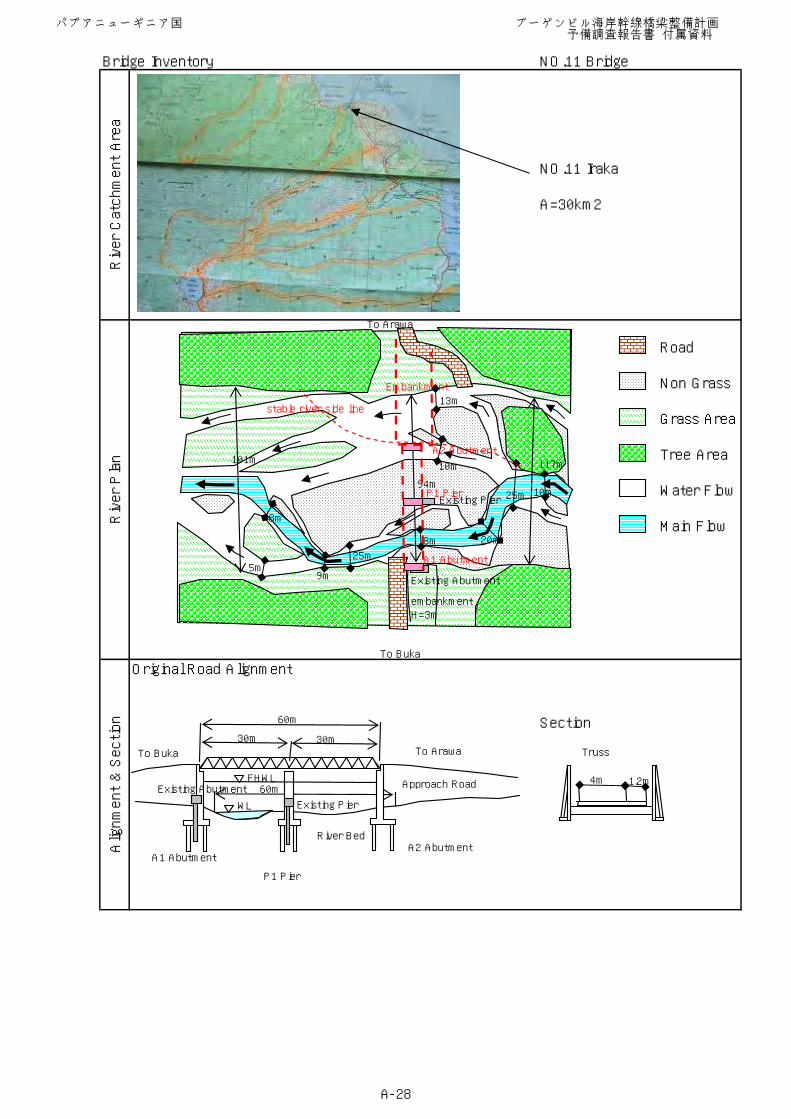
Bridge Inventory NO.11 Bridge
NO.11 Iraka
A=30km2
Original Road Alignment
Section
Alignment & Section
River Catchment Area
River Plan
Road
Non Grass
Grass Area
Tree Area
Water Flow
Main Flow
To Arawa
60mFHWL
WL
River Bed
Approach Road
60m
30m 30mTruss
4m 1.2m
117m
94m
101m
To Buka
Existing Abutment
Existing Pier
embankmentH=3m
25m 10m
20m8m
25m5m
8m
9m
Embankment
stable river side line
A2 Abutment
P1 Pier
A1 Abutment
A1 AbutmentA2 Abutment
P1 Pier
To Buka To Arawa
Existing Pier
Existing Abutment
13m
10m
パプアニューギニア国 ブーゲンビル海岸幹線橋梁整備計画 予備調査報告書 付属資料
A-28
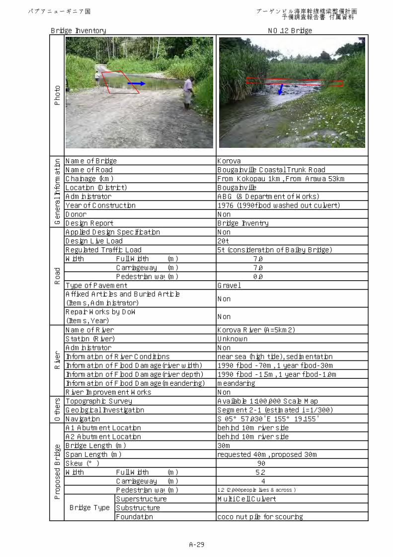
Bridge Inventory NO.12 Bridge
Name of Bridge KorovaName of Road Bougainville Coastal Trunk RoadChainage (km) From Kokopau 1km, From Arawa 53kmLocation (District) BougainvilleAdministrator ABG (& Department of Works)Year of Construction 1976 (1990flood washed out culvert)Donor NonDesign Report Bridge InventryApplied Design Specification NonDesign Live Load 20tRegulated Traffic Load 5t (consideration of Bailey Bridge)Width Full Width (m) 7.0
Carriageway (m) 7.0Pedestrian way(m) 0.0
Type of Pavement Gravel
Non
Non
Name of River Korova River (A=5km2)Station (River) UnknownAdministrator NonInformation of River Conditions near sea (high tide), sedimentationInformation of Flood Damage(river width) 1990 flood -70m, 1 year flood-30mInformation of Flood Damage(river depth) 1990 flood -1.5m, 1 year flood-1.0mInformation of Flood Damage(meandering) meandaringRiver Improvement Works NonTopographic Survey Available 1:100,000 Scale MapGeological Investigation Segment 2-1 (estimated i =1/300)Navigation S 05°57.030' E 155°19.155'A1 Abutment Location behind 10m river sideA2 Abutment Location behind 10m river sideBridge Length (m) 30mSpan Length (m) requested 40m, proposed 30mSkew (°) 90Width Full Width (m) 5.2
Carriageway (m) 4Pedestrian way(m) 1.2 (2,000people lives & across )
Superstructure Multi Cell CulvertSubstructureFoundation coco nut pile for scouring
Photo
General Information
Affixed Articles and Buried Article(Items, Administrator)
Bridge Type
Proposed Bridge
Repair Works by DoW(Items, Year)
Road
Others
River
パプアニューギニア国 ブーゲンビル海岸幹線橋梁整備計画 予備調査報告書 付属資料
A-29
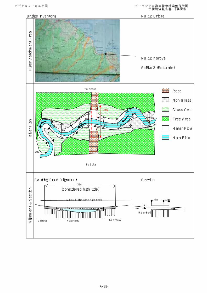
Bridge Inventory NO.12 Bridge
NO.12 Korova
A=5km2 (Estimate)
Existing Road Alignment Section
(considered high tide)
Alignment & Section
River Catchment Area
River Plan
Road
Non Grass
Grass Area
Tree Area
Water Flow
Main Flow
To Buka
To Arawa
FHWL (includes high tide)
River Bed
30m
4m 1.2m
WL
River Bed
WL
To Buka To Arawa
sea
debris20m20m
8m
9.5m9m
13m
8m
6m20m
12m
11m
30m
パプアニューギニア国 ブーゲンビル海岸幹線橋梁整備計画 予備調査報告書 付属資料
A-30
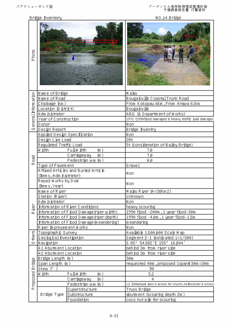
Bridge Inventory NO.14 Bridge
Name of Bridge MalasName of Road Bougainville Coastal Trunk RoadChainage (km) From Kokopau 6km, From Arawa 61kmLocation (District) BougainvilleAdministrator ABG (& Department of Works)Year of Construction 1972 (1990flood damaged & heavy traffic load damaged
Donor NonDesign Report Bridge InventryApplied Design Specification NonDesign Live Load 20tRegulated Traffic Load 5t (consideration of Bailey Bridge)Width Full Width (m) 7.0
Carriageway (m) 7.0Pedestrian way(m) 0.0
Type of Pavement Gravel
Non
Non
Name of River Malas River (A=38km2)Station (River) UnknownAdministrator NonInformation of River Conditions heavy scouringInformation of Flood Damage(river width) 1990 flood -200m, 1 year flood-30mInformation of Flood Damage(river depth) 1990 flood -4.0m, 1 year flood-1.5mInformation of Flood Damage(meandering) meandaringRiver Improvement Works NonTopographic Survey Available 1:100,000 Scale MapGeological Investigation Segment 2-1 (estimated i =1/300)Navigation S 05°54.582' E 155°16.844'A1 Abutment Location behind 3m from river sideA2 Abutment Location behind 3m from river sideBridge Length (m) 30mSpan Length (m) requested 40m, proposed 1span@30m=30mSkew (°) 90Width Full Width (m) 5.2
Carriageway (m) 4Pedestrian way(m) 1.2 (200people lives & across for church, helthcenter & school)
Superstructure Truss BridgeSubstructure abutment (scoaring depth 2m)Foundation coco nut pile for scouring
Photo
General Information
Affixed Articles and Buried Article(Items, Administrator)
Bridge Type
Proposed Bridge
Repair Works by DoW(Items, Year)
Road
Others
River
パプアニューギニア国 ブーゲンビル海岸幹線橋梁整備計画 予備調査報告書 付属資料
A-31
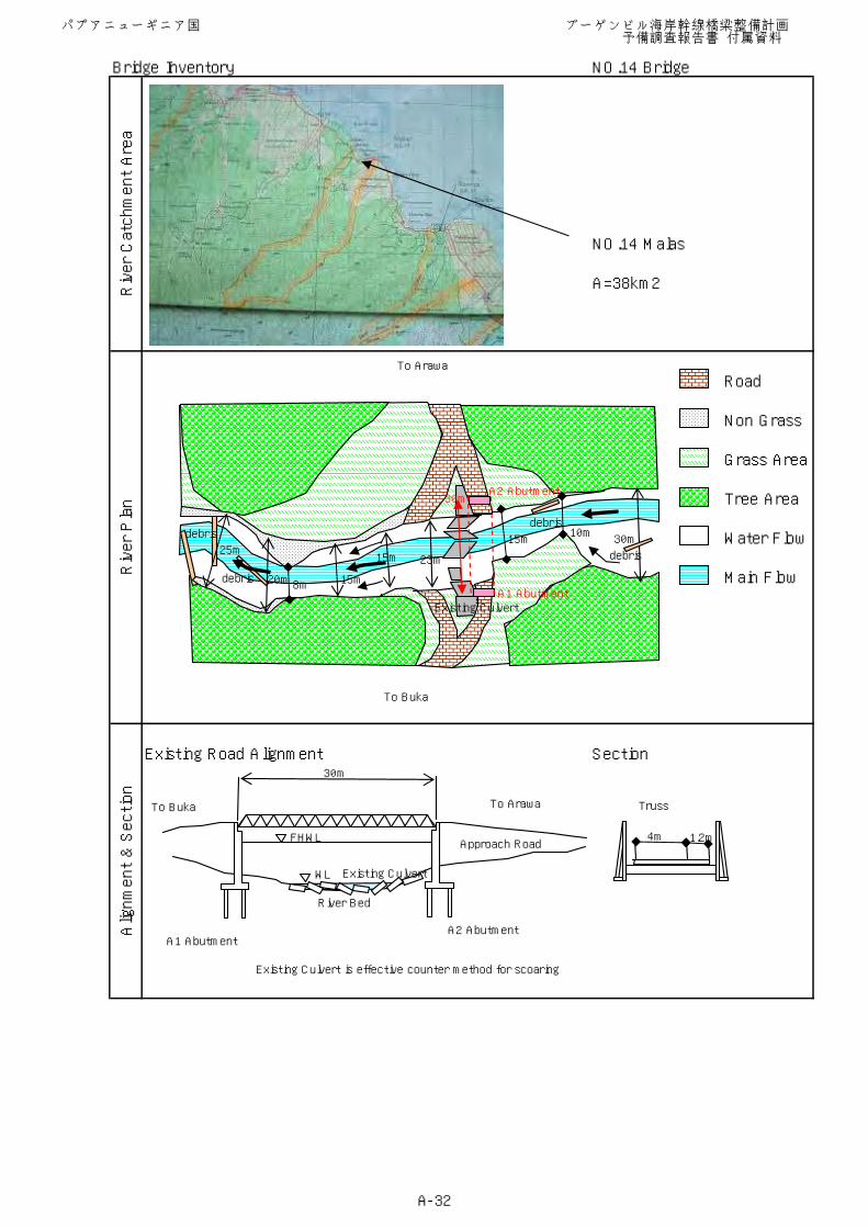
Bridge Inventory NO.14 Bridge
NO.14 Malas
A=38km2
Existing Road Alignment Section
Existing Culvert is effective counter method for scoaring
Alignment & Section
River Catchment Area
River Plan
Road
Non Grass
Grass Area
Tree Area
Water Flow
Main Flow
To Buka
To Arawa
FHWL
WL
River Bed
Approach Road
30m
Truss
4m 1.2m
A1 AbutmentA2 Abutment
To Buka To Arawa
30m10m
15m25m
20m 8m 15m
15m 23m
debris
debris
debris
debris
A2 Abutment
A1 Abutment
30m
Existing Culvert
Existing Culvert
パプアニューギニア国 ブーゲンビル海岸幹線橋梁整備計画 予備調査報告書 付属資料
A-32
Bridge Inventory NO.19 Bridge
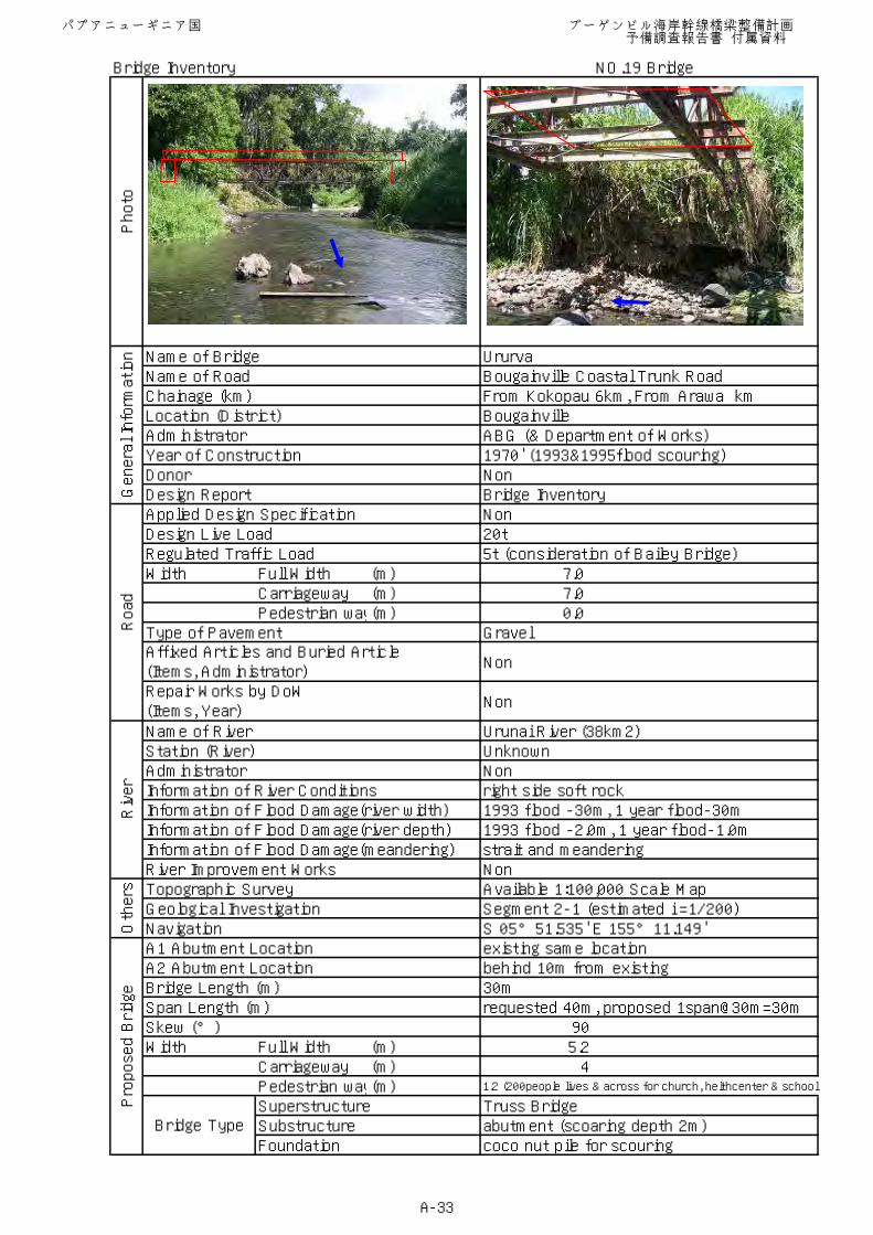
Name of Bridge UrurvaName of Road Bougainville Coastal Trunk RoadChainage (km) From Kokopau 6km, From Arawa kmLocation (District) BougainvilleAdministrator ABG (& Department of Works)Year of Construction 1970' (1993&1995flood scouring)Donor NonDesign Report Bridge InventoryApplied Design Specification NonDesign Live Load 20tRegulated Traffic Load 5t (consideration of Bailey Bridge)Width Full Width (m) 7.0
Carriageway (m) 7.0Pedestrian way(m) 0.0
Type of Pavement Gravel
Non
Non
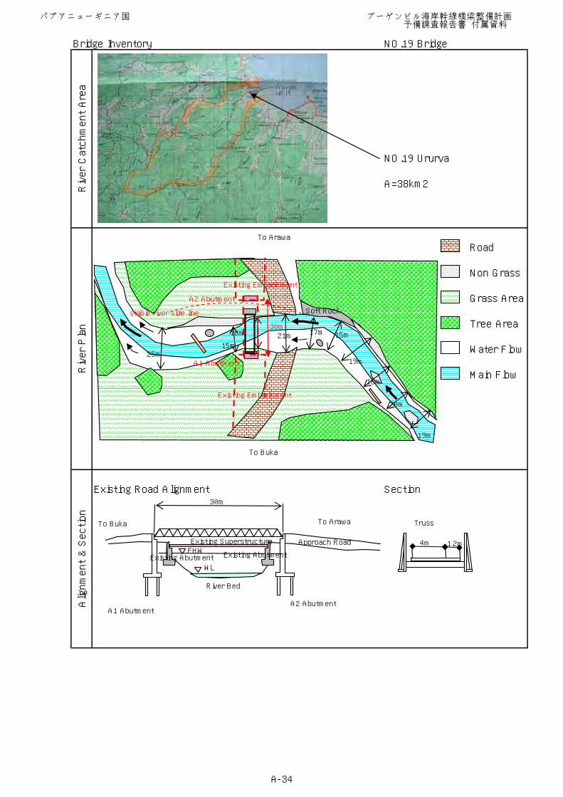
Name of River Urunai River (38km2)Station (River) UnknownAdministrator NonInformation of River Conditions right side soft rockInformation of Flood Damage(river width) 1993 flood -30m, 1 year flood-30mInformation of Flood Damage(river depth) 1993 flood -2.0m, 1 year flood-1.0mInformation of Flood Damage(meandering) strait and meanderingRiver Improvement Works NonTopographic Survey Available 1:100,000 Scale MapGeological Investigation Segment 2-1 (estimated i =1/200)Navigation S 05°51.535' E 155°11.149'A1 Abutment Location existing same locationA2 Abutment Location behind 10m from existingBridge Length (m) 30mSpan Length (m) requested 40m, proposed 1span@30m=30mSkew (°) 90Width Full Width (m) 5.2
Carriageway (m) 4Pedestrian way(m) 1.2 (200people lives & across for church, helthcenter & school)
Superstructure Truss BridgeSubstructure abutment (scoaring depth 2m)Foundation coco nut pile for scouring
Photo
General Information
Affixed Articles and Buried Article(Items, Administrator)
Bridge Type
Proposed Bridge
Repair Works by DoW(Items, Year)
Road
Others
River
パプアニューギニア国 ブーゲンビル海岸幹線橋梁整備計画 予備調査報告書 付属資料
A-33
Bridge Inventory NO.19 Bridge
NO.19 Ururva
A=38km2
Existing Road Alignment Section
Alignment & Section
River Catchment Area
River Plan
Road
Non Grass
Grass Area
Tree Area
Water Flow
Main Flow
To Buka
To Arawa
FHW
WL
River Bed
Approach Road
30m
Truss
4m 1.2m
A1 AbutmentA2 Abutment
To Buka To Arawa
Soft Rock
25m15m
18m 21m 17m 15m
19m
16m
20m
19m
A2 Abutment
A1 Abutment
Existing Embankment
Existing Embankment
30m
stable river side line
Existing AbutmentExisting Abutment
Existing Superstructure
パプアニューギニア国 ブーゲンビル海岸幹線橋梁整備計画 予備調査報告書 付属資料
A-34
Bridge Inventory NO.24 Bridge
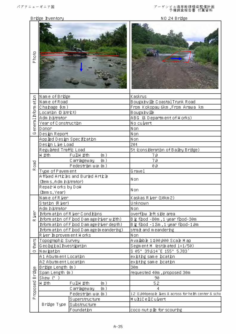
Name of Bridge KaskrusName of Road Bougainville Coastal Trunk RoadChainage (km) From Kokopau 6km, From Arawa kmLocation (District) BougainvilleAdministrator ABG (& Department of Works)Year of Construction No culvertDonor NonDesign Report NonApplied Design Specification NonDesign Live Load 20tRegulated Traffic Load 5t (consideration of Bailey Bridge)Width Full Width (m) 7.0
Carriageway (m) 7.0Pedestrian way(m) 0.0
Type of Pavement Gravel
Non
Non
Name of River Kaskas River (10km2)Station (River) UnknownAdministrator NonInformation of River Conditions overflow left side areaInformation of Flood Damage(river width) Big flood -80m, 1 year flood-30mInformation of Flood Damage(river depth) Big flood -1.5m, 1 year flood-1.0mInformation of Flood Damage(meandering) strait and meanderingRiver Improvement Works NonTopographic Survey Available 1:100,000 Scale MapGeological Investigation Segment M (estimated i =1/50)Navigation S 05°39.614' E 155°5.783'A1 Abutment Location existing same locationA2 Abutment Location existing same locationBridge Length (m) 30mSpan Length (m) requested 40m, proposed 30mSkew (°) 90Width Full Width (m) 5.2
Carriageway (m) 4Pedestrian way(m) 1.2 (1,000people lives & across for helth center & scho
Superstructure Multi Cell CulvertSubstructureFoundation coco nut pile for scouring
Photo
General Information
Affixed Articles and Buried Article(Items, Administrator)
Bridge Type
Proposed Bridge
Repair Works by DoW(Items, Year)
Road
Others
River
パプアニューギニア国 ブーゲンビル海岸幹線橋梁整備計画 予備調査報告書 付属資料
A-35
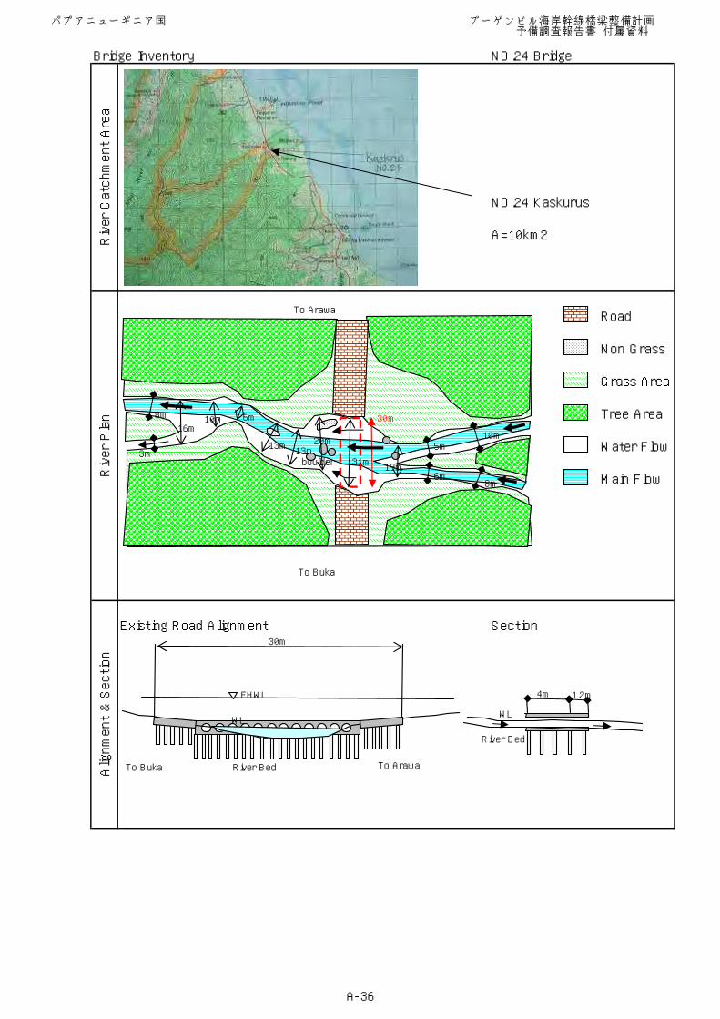
Bridge Inventory NO.24 Bridge
NO.24 Kaskurus
A=10km2
Existing Road Alignment Section
Alignment & Section
River Catchment Area
River Plan
Road
Non Grass
Grass Area
Tree Area
Water Flow
Main Flow
To Buka
To Arawa
FHWL
River Bed
30m
4m 1.2m
WL
River Bed
WL
To Buka To Arawa
boulder
8m
3m
16m10m 6m
13m13m
31m19m
20m5m
10m
6m8m
30m
パプアニューギニア国 ブーゲンビル海岸幹線橋梁整備計画 予備調査報告書 付属資料
A-36
Bridge Inventory NO.27 Bridge
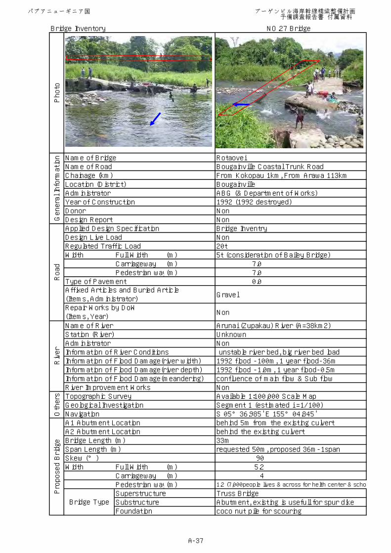
Name of Bridge RotaoveiName of Road Bougainville Coastal Trunk RoadChainage (km) From Kokopau 1km, From Arawa 113kmLocation (District) BougainvilleAdministrator ABG (& Department of Works)Year of Construction 1992 (1992 destroyed)Donor NonDesign Report NonApplied Design Specification Bridge InventryDesign Live Load NonRegulated Traffic Load 20tWidth Full Width (m) 5t (consideration of Bailey Bridge)
Carriageway (m) 7.0Pedestrian way(m) 7.0
Type of Pavement 0.0
Gravel
Non
Name of River Arunai (Zupakau) River (A=38km2)Station (River) UnknownAdministrator NonInformation of River Conditions unstable river bed, big river bed load Information of Flood Damage(river width) 1992 flood -100m, 1 year flood-36mInformation of Flood Damage(river depth) 1992 flood -1.0m, 1 year flood-0.5mInformation of Flood Damage(meandering) confluence of main flow & Sub flowRiver Improvement Works NonTopographic Survey Available 1:100,000 Scale MapGeological Investigation Segment 1 (estimated i =1/100)Navigation S 05°36.985' E 155°04.845'A1 Abutment Location behind 5m from the existing culvertA2 Abutment Location behind the existing culvertBridge Length (m) 33mSpan Length (m) requested 50m, proposed 36m-1spanSkew (°) 90Width Full Width (m) 5.2
Carriageway (m) 4Pedestrian way(m) 1.2 (7,000people lives & across for helth center & scho
Superstructure Truss BridgeSubstructure Abutment, existing is usefull for spur dikeFoundation coco nut pile for scouring
Photo
General Information
Affixed Articles and Buried Article(Items, Administrator)
Bridge Type
Proposed Bridge
Repair Works by DoW(Items, Year)
Road
Others
River
パプアニューギニア国 ブーゲンビル海岸幹線橋梁整備計画 予備調査報告書 付属資料
A-37
Bridge Inventory NO.27 Bridge
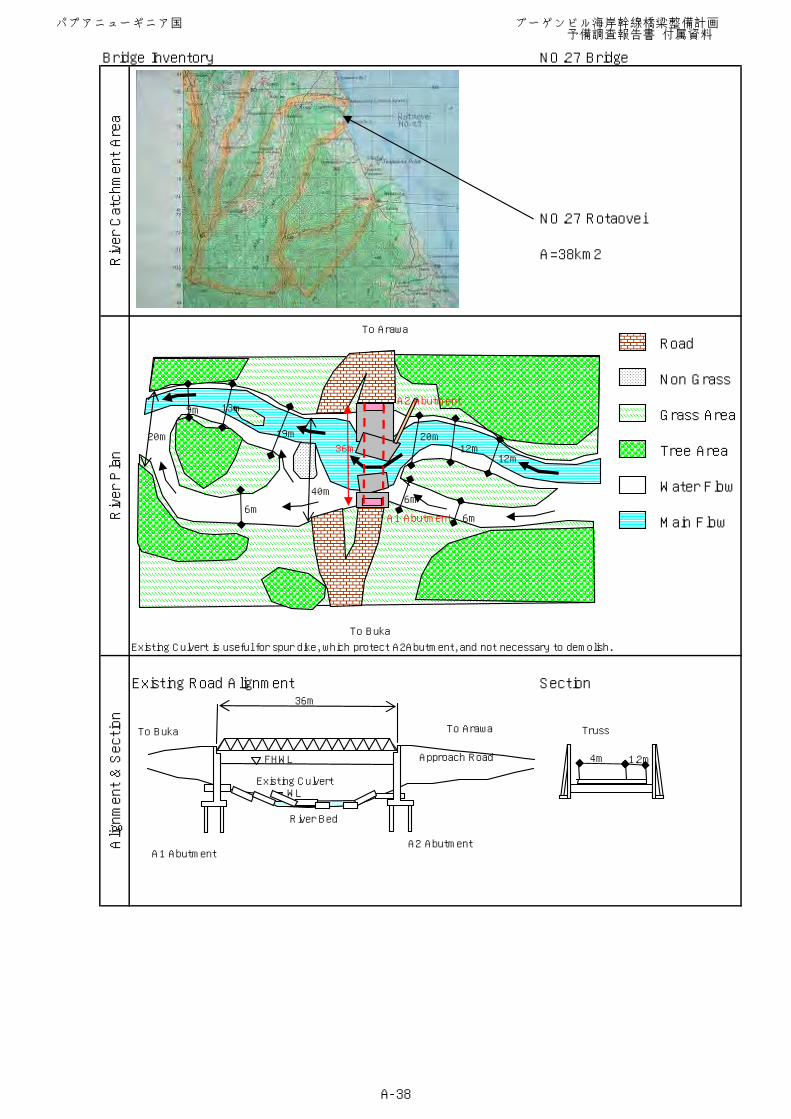
NO.27 Rotaovei
A=38km2
Existing Culvert is useful for spur dike, which protect A2Abutment, and not necessary to demolish.
Existing Road Alignment Section
Alignment & Section
River Catchment Area
River Plan
Road
Non Grass
Grass Area
Tree Area
Water Flow
Main Flow
To Buka
To Arawa
FHWL
WL
River Bed
Approach Road
36m
Truss
4m 1.2m
A1 AbutmentA2 Abutment
To Buka To Arawa
Existing Culvert
20m
9m 13m
19m
40m
6m
20m12m
6m
6m
12m
A2 Abutment
A1 Abutment
36m
パプアニューギニア国 ブーゲンビル海岸幹線橋梁整備計画 予備調査報告書 付属資料
A-38
Bridge Inventory NO.30 Bridge
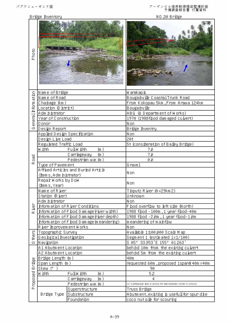
Name of Bridge WarakapisName of Road Bougainville Coastal Trunk RoadChainage (km) From Kokopau 5km, From Arawa 124kmLocation (District) BougainvilleAdministrator ABG (& Department of Works)Year of Construction 1970 (1988flood damaged culvert)Donor NonDesign Report Bridge InventryApplied Design Specification NonDesign Live Load 20tRegulated Traffic Load 5t (consideration of Bailey Bridge)Width Full Width (m) 7.0
Carriageway (m) 7.0Pedestrian way(m) 0.0
Type of Pavement Gravel
Non
Non
Name of River Tinputz River (A=29km2)Station (River) UnknownAdministrator NonInformation of River Conditions Flood overflow to left side (North)Information of Flood Damage(river width) 1988 flood -100m, 1 year flood-40mInformation of Flood Damage(river depth) 1988 flood -2.0m, 1 year flood-1.0mInformation of Flood Damage(meandering) meandering of mainflowRiver Improvement Works NonTopographic Survey Available 1:100,000 Scale MapGeological Investigation Segment 1 (estimated i =1/100)Navigation S 05°33.953' E 155°01.263'A1 Abutment Location behind 10m from the existing culvertA2 Abutment Location behind 5m from the existing culvertBridge Length (m) 40mSpan Length (m) requested 60m, proposed 1span@40m=40mSkew (°) 90Width Full Width (m) 5.2
Carriageway (m) 4Pedestrian way(m) 1.2 (1,500people lives & across for administation center & school)
Superstructure Truss BridgeSubstructure Abutment, existing is usefull for spur dikeFoundation coco nut pile for scouring
Photo
General Information
Affixed Articles and Buried Article(Items, Administrator)
Bridge Type
Proposed Bridge
Repair Works by DoW(Items, Year)
Road
Others
River
パプアニューギニア国 ブーゲンビル海岸幹線橋梁整備計画 予備調査報告書 付属資料
A-39
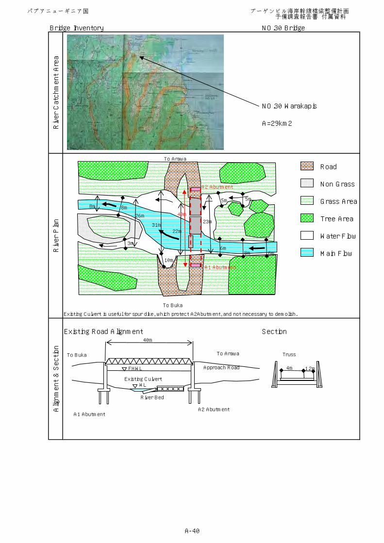
Bridge Inventory NO.30 Bridge
NO.30 Warakapis
A=29km2
Existing Culvert is useful for spur dike, which protect A2Abutment, and not necessary to demolish.
Existing Road Alignment Section
Alignment & Section
River Catchment Area
River Plan
Road
Non Grass
Grass Area
Tree Area
Water Flow
Main Flow
To Buka
To Arawa
FHWL
WL
River Bed
Approach Road
40m
Truss
4m 1.2m
A1 AbutmentA2 Abutment
To Buka To Arawa
Existing Culvert
8m 8m
3m
31m
10m
22m
23m
6m8m 6m
5m 5m
26m
A2 Abutment
A1 Abutment
40m
パプアニューギニア国 ブーゲンビル海岸幹線橋梁整備計画 予備調査報告書 付属資料
A-40
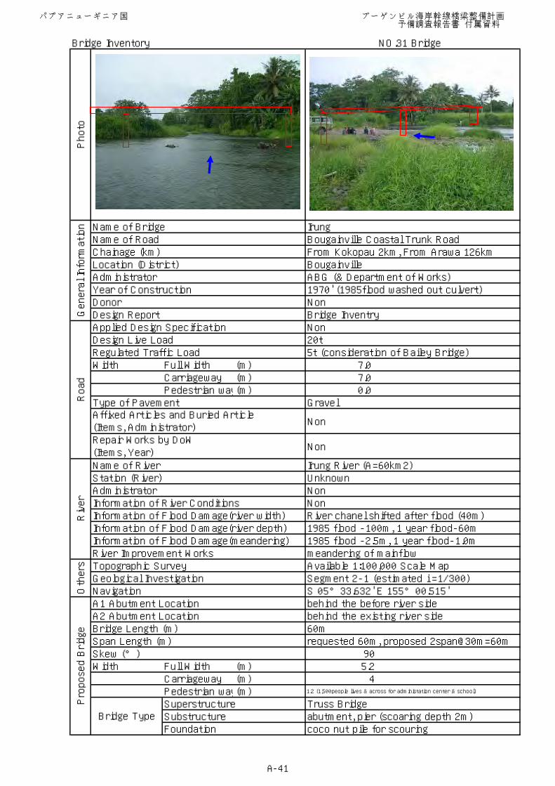
Bridge Inventory NO.31 Bridge
Name of Bridge IrungName of Road Bougainville Coastal Trunk RoadChainage (km) From Kokopau 2km, From Arawa 126kmLocation (District) BougainvilleAdministrator ABG (& Department of Works)Year of Construction 1970' (1985flood washed out culvert)Donor NonDesign Report Bridge InventryApplied Design Specification NonDesign Live Load 20tRegulated Traffic Load 5t (consideration of Bailey Bridge)Width Full Width (m) 7.0
Carriageway (m) 7.0Pedestrian way(m) 0.0
Type of Pavement Gravel
Non
Non
Name of River Irung River (A=60km2)Station (River) UnknownAdministrator NonInformation of River Conditions NonInformation of Flood Damage(river width) River chanel shifted after flood (40m)Information of Flood Damage(river depth) 1985 flood -100m, 1 year flood-60mInformation of Flood Damage(meandering) 1985 flood -2.5m, 1 year flood-1.0mRiver Improvement Works meandering of mainflowTopographic Survey Available 1:100,000 Scale MapGeological Investigation Segment 2-1 (estimated i =1/300)Navigation S 05°33.632' E 155°00.515'A1 Abutment Location behind the before river sideA2 Abutment Location behind the existing river sideBridge Length (m) 60mSpan Length (m) requested 60m, proposed 2span@30m=60mSkew (°) 90Width Full Width (m) 5.2
Carriageway (m) 4Pedestrian way(m) 1.2 (1,500people lives & across for administation center & school)
Superstructure Truss BridgeSubstructure abutment, pier (scoaring depth 2m)Foundation coco nut pile for scouring
Photo
General Information
Affixed Articles and Buried Article(Items, Administrator)
Bridge Type
Proposed Bridge
Repair Works by DoW(Items, Year)
Road
Others
River
パプアニューギニア国 ブーゲンビル海岸幹線橋梁整備計画 予備調査報告書 付属資料
A-41
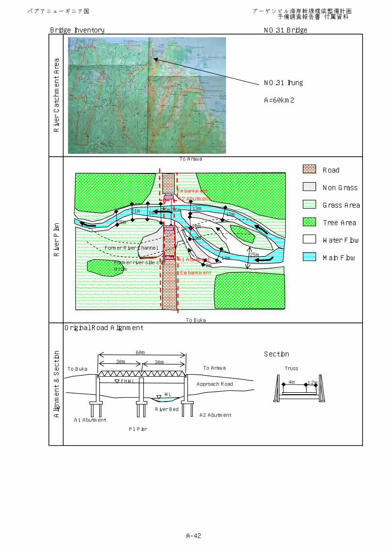
Bridge Inventory NO.31 Bridge
NO.31 Irung
A=60km2
Original Road Alignment
Section
Alignment & Section
River Catchment Area
River Plan
Road
Non Grass
Grass Area
Tree Area
Water Flow
Main Flow
To Arawa
FHWL
WL
River Bed
Approach Road
60m
30m 30mTruss
4m 1.2m
To Buka
A1 AbutmentA2 Abutment
P1 Pier
To Buka To Arawa
Embankment
A2 Abutment
P1 Pier
A1 AbutmentFormer river side cliffH=2m
Former River Channel
Embankment
25m
21m 18m25m36m 13m
13m
10m
13m
14m
3m
25m
パプアニューギニア国 ブーゲンビル海岸幹線橋梁整備計画 予備調査報告書 付属資料
A-42
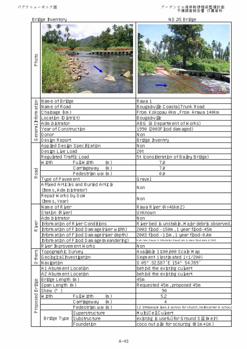
Bridge Inventory NO.35 Bridge
Name of Bridge Rawa 1Name of Road Bougainville Coastal Trunk RoadChainage (km) From Kokopau 0km, From Arawa 140kmLocation (District) BougainvilleAdministrator ABG (& Department of Works)Year of Construction 1990 (2003Flood damaged)Donor NonDesign Report Bridge InventryApplied Design Specification NonDesign Live Load 20tRegulated Traffic Load 5t (consideration of Bailey Bridge)Width Full Width (m) 7.0
Carriageway (m) 7.0Pedestrian way(m) 0.0
Type of Pavement Gravel
Non
Non
Name of River Rawa River (A=46km2)Station (River) UnknownAdministrator NonInformation of River Conditions River bed is unstable. Major debris observed.Information of Flood Damage(river width) 2003 flood -150m, 1 year flood-45mInformation of Flood Damage(river depth) 2003 flood -1.5m, 1 year flood-0.4mInformation of Flood Damage(meandering) Main river, Rawa1 & tributaries, Rawa2 are in same flood area in 2003
River Improvement Works NonTopographic Survey Available 1:100,000 Scale MapGeological Investigation Segment 1(estimated i =1/200)Navigation S 05°32.587' E 154°54.789'A1 Abutment Location behind the existing culvertA2 Abutment Location behind the existing culvertBridge Length (m) 45mSpan Length (m) Requested 45m, proposed 45mSkew (°) 90Width Full Width (m) 5.2
Carriageway (m) 4Pedestrian way(m) 1.2 (200people lives & across for church, helthcenter & school)
Superstructure Multi Cell CulvertSubstructure existing is useful for Ground Sill (Weir)Foundation coco nut pile for scouring (@1m*1m)
Photo
General Information
Affixed Articles and Buried Article(Items, Administrator)
Bridge Type
Proposed Bridge
Repair Works by DoW(Items, Year)
Road
Others
River
パプアニューギニア国 ブーゲンビル海岸幹線橋梁整備計画 予備調査報告書 付属資料
A-43
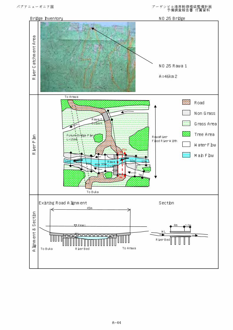
Bridge Inventory NO.35 Bridge
NO.35 Rawa 1
A=46km2
Existing Road Alignment Section
Alignment & Section
River Catchment Area
River Plan
Road
Non Grass
Grass Area
Tree Area
Water Flow
Main Flow
To Buka
FHWL
River Bed
45m
4m 1.2m
WL
River Bed
WL
To Buka To Arawa
To Arawa
Rawa 2Culvert
Rawa 1Culvert
Future Bridge PlanL=150m
RawaRiverFlood River Width
50m 41m 41m 46m33m
41m
31m32m 12m
7m
45m
パプアニューギニア国 ブーゲンビル海岸幹線橋梁整備計画 予備調査報告書 付属資料
A-44
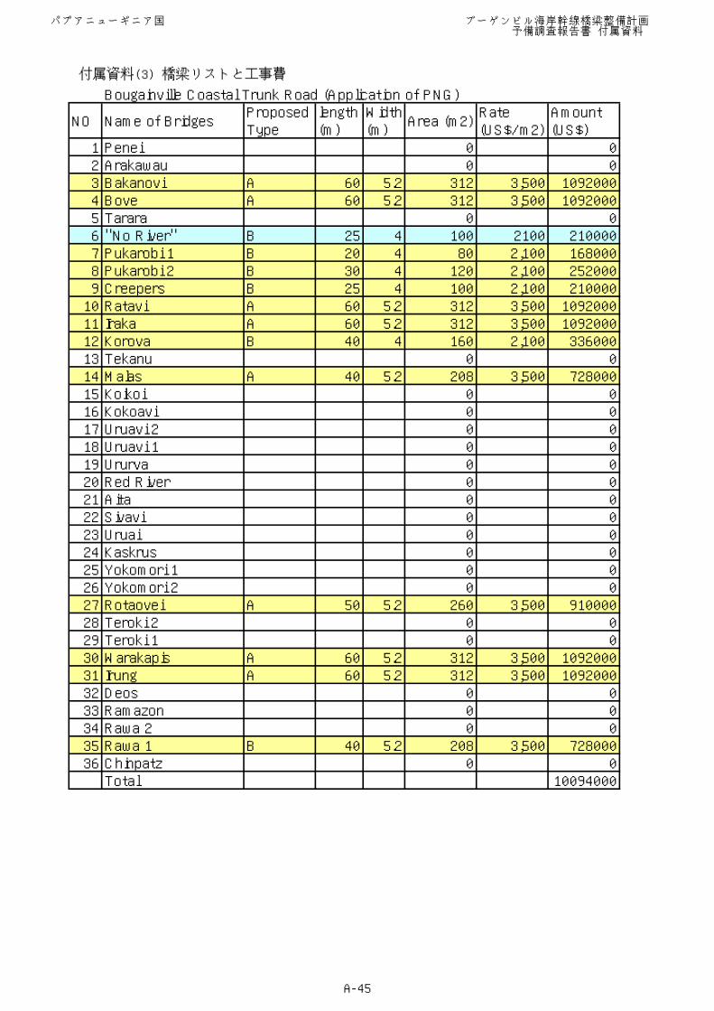
Bougainville Coastal Trunk Road (Application of PNG)
NO Name of BridgesProposedType
length(m)
Width(m)
Area (m2)Rate(US$/m2)
Amount(US$)
1 Penei 0 02 Arakawau 0 03 Bakanovi A 60 5.2 312 3,500 10920004 Bove A 60 5.2 312 3,500 10920005 Tarara 0 06 "No River" B 25 4 100 2100 2100007 Pukarobi 1 B 20 4 80 2,100 1680008 Pukarobi 2 B 30 4 120 2,100 2520009 Creepers B 25 4 100 2,100 21000010 Ratavi A 60 5.2 312 3,500 109200011 Iraka A 60 5.2 312 3,500 109200012 Korova B 40 4 160 2,100 33600013 Tekanu 0 014 Malas A 40 5.2 208 3,500 72800015 Koikoi 0 016 Kokoavi 0 017 Uruavi 2 0 018 Uruavi 1 0 019 Ururva 0 020 Red River 0 021 Aita 0 022 Sivavi 0 023 Uruai 0 024 Kaskrus 0 025 Yokomori 1 0 026 Yokomori 2 0 027 Rotaovei A 50 5.2 260 3,500 91000028 Teroki 2 0 029 Teroki 1 0 030 Warakapis A 60 5.2 312 3,500 109200031 Irung A 60 5.2 312 3,500 109200032 Deos 0 033 Ramazon 0 034 Rawa 2 0 035 Rawa 1 B 40 5.2 208 3,500 72800036 Chinpatz 0 0Total 10094000
パプアニューギニア国 ブーゲンビル海岸幹線橋梁整備計画 予備調査報告書 付属資料
A-45
付属資料(3) 橋梁リストと工事費
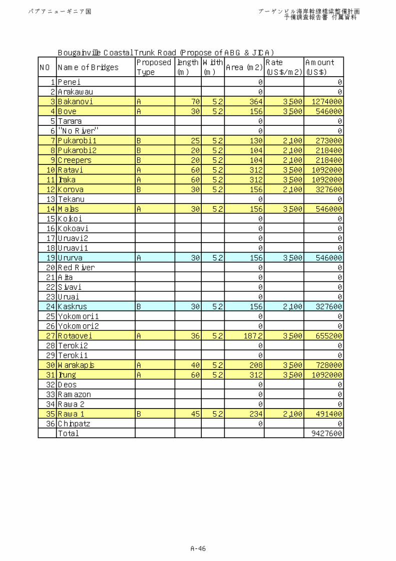
Bougainville Coastal Trunk Road (Propose of ABG & JICA)
NO Name of BridgesProposedType
length(m)
Width(m)
Area (m2)Rate(US$/m2)
Amount(US$)
1 Penei 0 02 Arakawau 0 03 Bakanovi A 70 5.2 364 3,500 12740004 Bove A 30 5.2 156 3,500 5460005 Tarara 0 06 "No River" 0 07 Pukarobi 1 B 25 5.2 130 2,100 2730008 Pukarobi 2 B 20 5.2 104 2,100 2184009 Creepers B 20 5.2 104 2,100 21840010 Ratavi A 60 5.2 312 3,500 109200011 Iraka A 60 5.2 312 3,500 109200012 Korova B 30 5.2 156 2,100 32760013 Tekanu 0 014 Malas A 30 5.2 156 3,500 54600015 Koikoi 0 016 Kokoavi 0 017 Uruavi 2 0 018 Uruavi 1 0 019 Ururva A 30 5.2 156 3,500 54600020 Red River 0 021 Aita 0 022 Sivavi 0 023 Uruai 0 024 Kaskrus B 30 5.2 156 2,100 32760025 Yokomori 1 0 026 Yokomori 2 0 027 Rotaovei A 36 5.2 187.2 3,500 65520028 Teroki 2 0 029 Teroki 1 0 030 Warakapis A 40 5.2 208 3,500 72800031 Irung A 60 5.2 312 3,500 109200032 Deos 0 033 Ramazon 0 034 Rawa 2 0 035 Rawa 1 B 45 5.2 234 2,100 49140036 Chinpatz 0 0Total 9427600
パプアニューギニア国 ブーゲンビル海岸幹線橋梁整備計画 予備調査報告書 付属資料
A-46
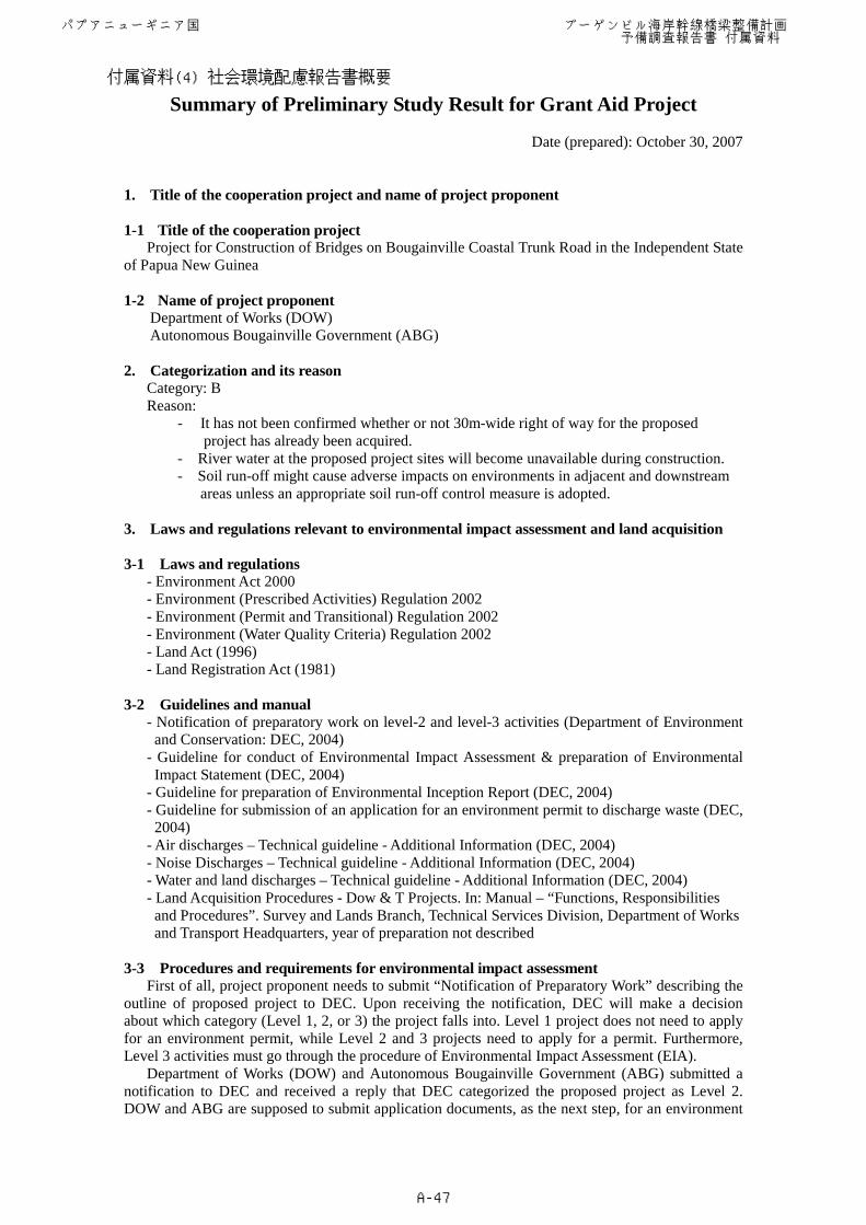
Summary of Preliminary Study Result for Grant Aid Project
Date (prepared): October 30, 2007
1. Title of the cooperation project and name of project proponent 1-1 Title of the cooperation project
Project for Construction of Bridges on Bougainville Coastal Trunk Road in the Independent State of Papua New Guinea
1-2 Name of project proponent
Department of Works (DOW) Autonomous Bougainville Government (ABG)
2. Categorization and its reason
Category: B Reason:
- It has not been confirmed whether or not 30m-wide right of way for the proposed project has already been acquired.
- River water at the proposed project sites will become unavailable during construction. - Soil run-off might cause adverse impacts on environments in adjacent and downstream
areas unless an appropriate soil run-off control measure is adopted. 3. Laws and regulations relevant to environmental impact assessment and land acquisition 3-1 Laws and regulations
- Environment Act 2000 - Environment (Prescribed Activities) Regulation 2002 - Environment (Permit and Transitional) Regulation 2002 - Environment (Water Quality Criteria) Regulation 2002 - Land Act (1996) - Land Registration Act (1981)
3-2 Guidelines and manual
- Notification of preparatory work on level-2 and level-3 activities (Department of Environment and Conservation: DEC, 2004)
- Guideline for conduct of Environmental Impact Assessment & preparation of Environmental Impact Statement (DEC, 2004)
- Guideline for preparation of Environmental Inception Report (DEC, 2004) - Guideline for submission of an application for an environment permit to discharge waste (DEC,
2004) - Air discharges – Technical guideline - Additional Information (DEC, 2004) - Noise Discharges – Technical guideline - Additional Information (DEC, 2004) - Water and land discharges – Technical guideline - Additional Information (DEC, 2004) - Land Acquisition Procedures - Dow & T Projects. In: Manual – “Functions, Responsibilities
and Procedures”. Survey and Lands Branch, Technical Services Division, Department of Works and Transport Headquarters, year of preparation not described
3-3 Procedures and requirements for environmental impact assessment
First of all, project proponent needs to submit “Notification of Preparatory Work” describing the outline of proposed project to DEC. Upon receiving the notification, DEC will make a decision about which category (Level 1, 2, or 3) the project falls into. Level 1 project does not need to apply for an environment permit, while Level 2 and 3 projects need to apply for a permit. Furthermore, Level 3 activities must go through the procedure of Environmental Impact Assessment (EIA).
Department of Works (DOW) and Autonomous Bougainville Government (ABG) submitted a notification to DEC and received a reply that DEC categorized the proposed project as Level 2. DOW and ABG are supposed to submit application documents, as the next step, for an environment
パプアニューギニア国 ブーゲンビル海岸幹線橋梁整備計画 予備調査報告書 付属資料
A-47
付属資料(4) 社会環境配慮報告書概要
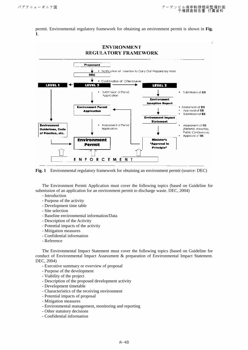
permit. Environmental regulatory framework for obtaining an environment permit is shown in Fig. 1.
Fig. 1 Environmental regulatory framework for obtaining an environment permit (source: DEC)
The Environment Permit Application must cover the following topics (based on Guideline for submission of an application for an environment permit to discharge waste. DEC, 2004)
- Introduction - Purpose of the activity - Development time table - Site selection - Baseline environmental information/Data - Description of the Activity - Potential impacts of the activity - Mitigation measures - Confidential information - Reference
The Environmental Impact Statement must cover the following topics (based on Guideline for
conduct of Environmental Impact Assessment & preparation of Environmental Impact Statement. DEC, 2004)
- Executive summary or overview of proposal - Purpose of the development - Viability of the project - Description of the proposed development activity - Development timetable - Characteristics of the receiving environment - Potential impacts of proposal - Mitigation measures - Environmental management, monitoring and reporting - Other statutory decisions - Confidential information
パプアニューギニア国 ブーゲンビル海岸幹線橋梁整備計画 予備調査報告書 付属資料
A-48
- References - Acknowledgements - Study team
3-4 Information disclosure and public participation
Any Environmental Impact Statement (EIS) must be made available for public review. The Environment Act 2000 (section 55) prescribes the public review process of EIS for Level 3 projects (section 51). 3-5 Land acquisition
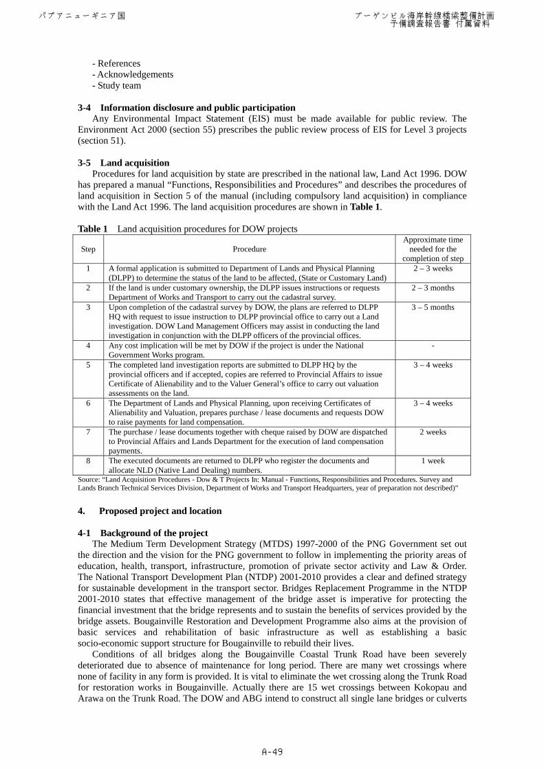
Procedures for land acquisition by state are prescribed in the national law, Land Act 1996. DOW has prepared a manual “Functions, Responsibilities and Procedures” and describes the procedures of land acquisition in Section 5 of the manual (including compulsory land acquisition) in compliance with the Land Act 1996. The land acquisition procedures are shown in Table 1. Table 1 Land acquisition procedures for DOW projects
Step Procedure Approximate time
needed for the completion of step
1 A formal application is submitted to Department of Lands and Physical Planning (DLPP) to determine the status of the land to be affected, (State or Customary Land)
2 – 3 weeks
2 If the land is under customary ownership, the DLPP issues instructions or requests Department of Works and Transport to carry out the cadastral survey.
2 – 3 months
3 Upon completion of the cadastral survey by DOW, the plans are referred to DLPP HQ with request to issue instruction to DLPP provincial office to carry out a Land investigation. DOW Land Management Officers may assist in conducting the land investigation in conjunction with the DLPP officers of the provincial offices.
3 – 5 months
4 Any cost implication will be met by DOW if the project is under the National Government Works program.
-
5 The completed land investigation reports are submitted to DLPP HQ by the provincial officers and if accepted, copies are referred to Provincial Affairs to issue Certificate of Alienability and to the Valuer General’s office to carry out valuation assessments on the land.
3 – 4 weeks
6 The Department of Lands and Physical Planning, upon receiving Certificates of Alienability and Valuation, prepares purchase / lease documents and requests DOW to raise payments for land compensation.
3 – 4 weeks
7 The purchase / lease documents together with cheque raised by DOW are dispatched to Provincial Affairs and Lands Department for the execution of land compensation payments.
2 weeks
8 The executed documents are returned to DLPP who register the documents and allocate NLD (Native Land Dealing) numbers.
1 week
Source: “Land Acquisition Procedures - Dow & T Projects In: Manual - Functions, Responsibilities and Procedures. Survey and Lands Branch Technical Services Division, Department of Works and Transport Headquarters, year of preparation not described)” 4. Proposed project and location 4-1 Background of the project
The Medium Term Development Strategy (MTDS) 1997-2000 of the PNG Government set out the direction and the vision for the PNG government to follow in implementing the priority areas of education, health, transport, infrastructure, promotion of private sector activity and Law & Order. The National Transport Development Plan (NTDP) 2001-2010 provides a clear and defined strategy for sustainable development in the transport sector. Bridges Replacement Programme in the NTDP 2001-2010 states that effective management of the bridge asset is imperative for protecting the financial investment that the bridge represents and to sustain the benefits of services provided by the bridge assets. Bougainville Restoration and Development Programme also aims at the provision of basic services and rehabilitation of basic infrastructure as well as establishing a basic socio-economic support structure for Bougainville to rebuild their lives.
Conditions of all bridges along the Bougainville Coastal Trunk Road have been severely deteriorated due to absence of maintenance for long period. There are many wet crossings where none of facility in any form is provided. It is vital to eliminate the wet crossing along the Trunk Road for restoration works in Bougainville. Actually there are 15 wet crossings between Kokopau and Arawa on the Trunk Road. The DOW and ABG intend to construct all single lane bridges or culverts
パプアニューギニア国 ブーゲンビル海岸幹線橋梁整備計画 予備調査報告書 付属資料
A-49
on all the wet crossing sites. Benefits derived from the construction of 15 bridges and culverts are substantial for the revitalization and development of the Bougainville economy. In August 2006, the DOW requested Japan’s Grant Aid for the construction of the priority bridges and culverts on the Bougainville Costal Trunk Road. 4-2 Objectives of the project
The objective of the project is to construct bridges and culverts on Bougainville Coastal Trunk Road, in order to support provincial security and secure economic development and provincial cohesion. 4-3 Project sites
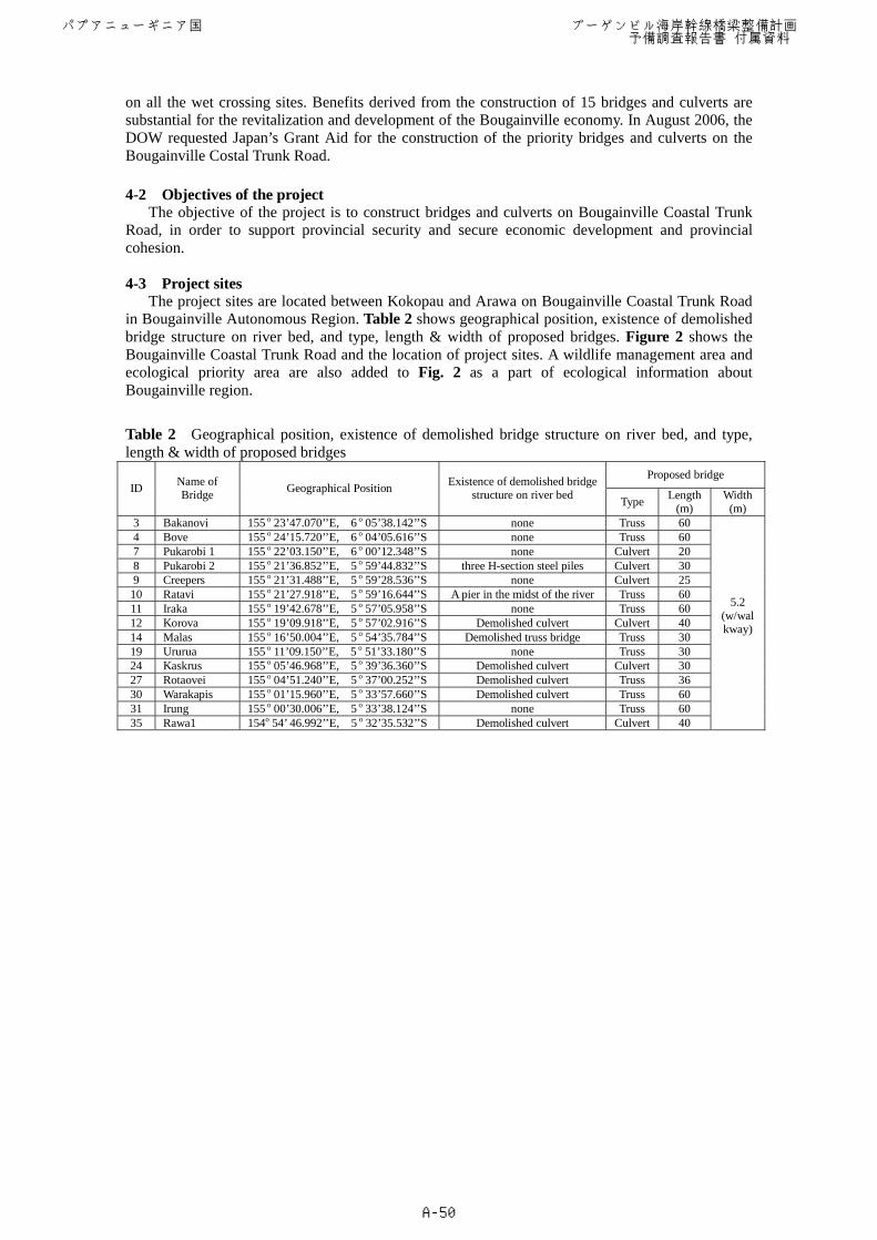
The project sites are located between Kokopau and Arawa on Bougainville Coastal Trunk Road in Bougainville Autonomous Region. Table 2 shows geographical position, existence of demolished bridge structure on river bed, and type, length & width of proposed bridges. Figure 2 shows the Bougainville Coastal Trunk Road and the location of project sites. A wildlife management area and ecological priority area are also added to Fig. 2 as a part of ecological information about Bougainville region.
Table 2 Geographical position, existence of demolished bridge structure on river bed, and type, length & width of proposed bridges
Proposed bridge ID Name of
Bridge Geographical Position Existence of demolished bridge structure on river bed Type Length
(m) Width
(m) 3 Bakanovi 155 o 23’47.070’’E, 6 o 05’38.142’’S none Truss 60 4 Bove 155 o 24’15.720’’E, 6 o 04’05.616’’S none Truss 60 7 Pukarobi 1 155 o 22’03.150’’E, 6 o 00’12.348’’S none Culvert 20 8 Pukarobi 2 155 o 21’36.852’’E, 5 o 59’44.832’’S three H-section steel piles Culvert 30 9 Creepers 155 o 21’31.488’’E, 5 o 59’28.536’’S none Culvert 25
10 Ratavi 155 o 21’27.918’’E, 5 o 59’16.644’’S A pier in the midst of the river Truss 60 11 Iraka 155 o 19’42.678’’E, 5 o 57’05.958’’S none Truss 60 12 Korova 155 o 19’09.918’’E, 5 o 57’02.916’’S Demolished culvert Culvert 40 14 Malas 155 o 16’50.004’’E, 5 o 54’35.784’’S Demolished truss bridge Truss 30 19 Ururua 155 o 11’09.150’’E, 5 o 51’33.180’’S none Truss 30 24 Kaskrus 155 o 05’46.968’’E, 5 o 39’36.360’’S Demolished culvert Culvert 30 27 Rotaovei 155 o 04’51.240’’E, 5 o 37’00.252’’S Demolished culvert Truss 36 30 Warakapis 155 o 01’15.960’’E, 5 o 33’57.660’’S Demolished culvert Truss 60 31 Irung 155 o 00’30.006’’E, 5 o 33’38.124’’S none Truss 60 35 Rawa1 154o 54’ 46.992’’E, 5 o 32’35.532’’S Demolished culvert Culvert 40
5.2 (w/walkway)
パプアニューギニア国 ブーゲンビル海岸幹線橋梁整備計画 予備調査報告書 付属資料
A-50
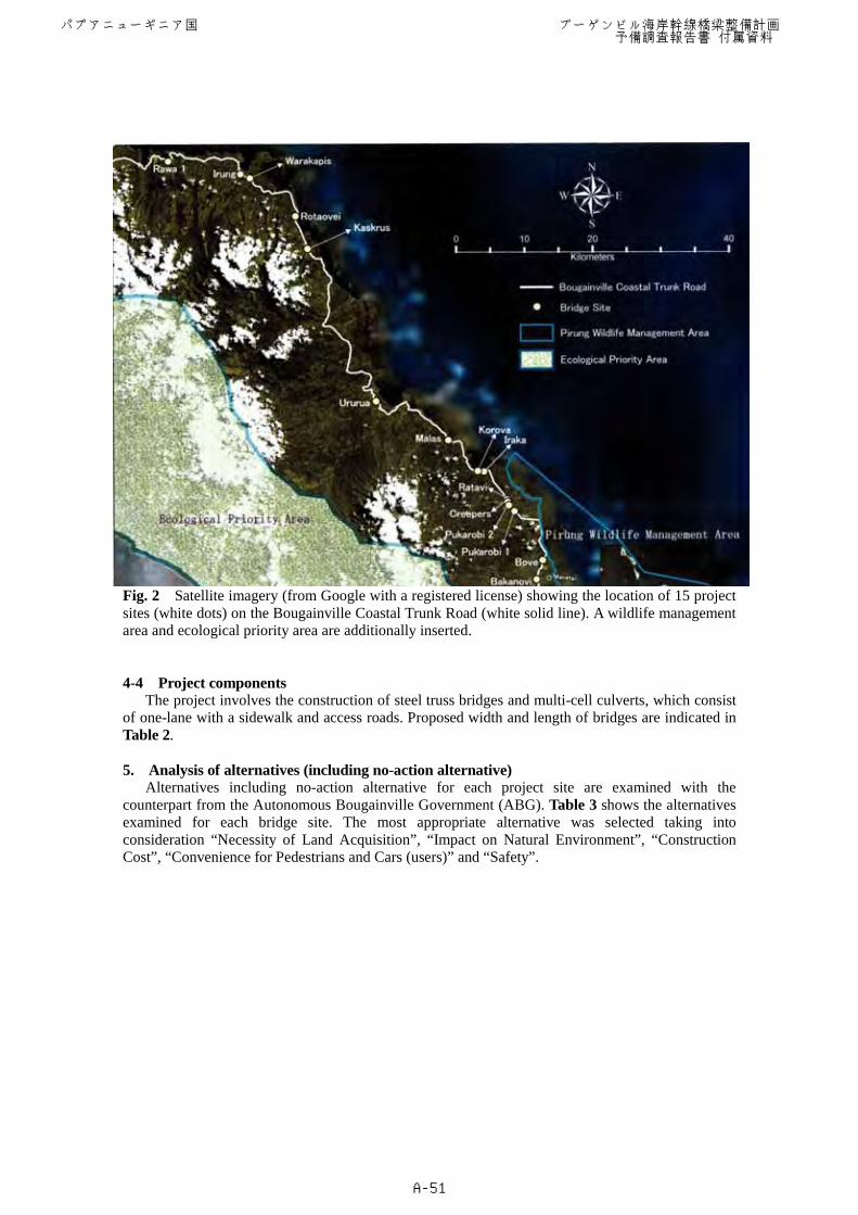
Fig. 2 Satellite imagery (from Google with a registered license) showing the location of 15 project sites (white dots) on the Bougainville Coastal Trunk Road (white solid line). A wildlife management area and ecological priority area are additionally inserted. 4-4 Project components The project involves the construction of steel truss bridges and multi-cell culverts, which consist of one-lane with a sidewalk and access roads. Proposed width and length of bridges are indicated in Table 2. 5. Analysis of alternatives (including no-action alternative)
Alternatives including no-action alternative for each project site are examined with the counterpart from the Autonomous Bougainville Government (ABG). Table 3 shows the alternatives examined for each bridge site. The most appropriate alternative was selected taking into consideration “Necessity of Land Acquisition”, “Impact on Natural Environment”, “Construction Cost”, “Convenience for Pedestrians and Cars (users)” and “Safety”.
パプアニューギニア国 ブーゲンビル海岸幹線橋梁整備計画 予備調査報告書 付属資料
A-51
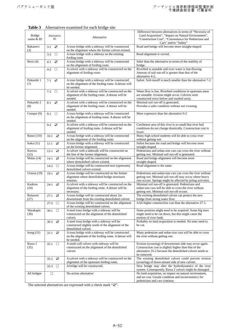
Table 3 Alternatives examined for each bridge site
Bridge name & ID
Alternative ID Alternative
Difference between alternatives in terms of “Necessity of Land Acquisition”, “Impact on Natural Environment”, “Construction Cost”, “Convenience for Pedestrians and
Cars” and/or “Safety” Bakanovi (3)
3-1 A truss bridge with a sideway will be constructed on the alignment where the former culvert existed.
Road and bridge will become more straight-shaped.
3-2 A truss bridge with a sideway on the existing fording route
Road alignment is curved.
Bove (4) 4-1 A truss bridge with a sideway will be constructed on the alignment of fording route.
Safer than the alternative in terms of the stability of bridge.
4-2 A culvert with a sideway will be constructed on the
alignment of fording route. Riverbed is unstable and river water is fast-flowing. Amount of soil run-off is greater than that of the alternative 4-2.
Pukarobi 1 (7)
7-1 A truss bridge with a sideway will be constructed on the alignment of the fording route. A detour will be needed.
Safest. Soil-runoff is much smaller than the alternative 7-2
7-2 A culvert with a sideway will be constructed on the alignment of the fording route. A detour will be needed.
Water flow is fast. Riverbed conditions in upstream areas are unstable. Erosion might occur. Culverts were constructed twice before and washed away.
Pukarobi 2 (8)
8-1 A culvert with a sideway will be constructed on the alignment of the fording route. A detour will be needed.
Minimal soil run-off is generated. Provides a safer condition without wet crossing.
Creeper (9) 9-1 A truss bridge with a sideway will be constructed on the alignment of fording route. A detour will be needed.
More expensive than the alternative 9-2
9-2 A culvert with a sideway will be constructed on the alignment of fording route. A detour will be needed.
Catchment area of this river is so small that river bed conditions do not change drastically. Construction cost is lower
Ratavi (10) 10-1 A truss bridge with a sideway will be constructed on the alignment of the fording route.
Many high school students will be able to cross river without getting wet.
Iraka (11) 11-1 A truss bridge with a sideway will be constructed on the former alignment.
Safest because the road and bridge will become more straight-shaped.
Korova (12)
12-1 A culvert with a sidewalk will be constructed on the line of the former alignment.
Pedestrians and sedan-size cars can cross the river without getting wet. Minimal soil run-off is generated.
Malas (14)
14-1 A truss bridge will be constructed on the alignment where demolished culvert existed.
Road and bridge alignment will become more straight-shaped.
14-2 A truss bridge will be constructed next (upstream) demolished culvert existed.
Road alignment is the same.
Ururua (19) 19-1 A truss bridge will be constructed on the former alignment where demolished bridge structures remains.
Pedestrians and sedan-size cars can cross the river without getting wet. Minimal soil run-off may occur where heavy rain occurs. Springs might be affected by piling activities.
Kaskrus (24)
24-1 A culvert with a sideway will be constructed on the alignment of the fording route. A detour will be necessary.
Minimal soil run-off is generated. Pedestrians and sedan-size cars will be able to cross the river without getting wet. Minimal soil run-off occurs.
Rotaovei (27)
27-1 A truss bridge will be constructed about 2m downstream from the existing demolished culvert.
The existing demolished culvert can protect the new bridge from strong water flow.
27-2 A truss bridge will be constructed on the alignment of the existing demolished culvert.
A bit higher construction cost than the alternative 27-1.
Warakapis (30)
30-1 A steel truss bridge with a sideway will be constructed on the alignment of the demolished culvert.
Some portions might need to be acquired. Some big trees might need to be cut down, but this might cause the erosion of river bank.
30-2 A steel truss bridge with a sideway will be
constructed slightly south of the alignment of the demolished culvert.
Probably no land acquisition is needed. No trees need to be cut.
Irung (31) 31-1 A truss bridge with a sideway will be constructed on the alignment of the fording route. A detour will be needed.
Many pedestrian and sedan-size cars will be able to cross the river without getting wet.
Rawa 1 (35)
35-1 A multi-cell culvert with sideway will be constructed on the alignment of the demolished culvert.
Erosion (scouring) of downstream side may occur again. Construction cost is slightly higher than that of the alternative 35-2 because the demolished culvert needs to be removed.
35-2 A culvert with a sideway will be constructed on the alignment of the upstream fording route.
The existing demolished culvert could prevent erosion (scouring) of down-stream side of new culvert.
35-3 A bridge will be constructed. New bridge may alter the hydrodynamics of the river system. Consequently, Rawa 2 culvert might be damaged.
All bridges No-action alternative No land acquisition, no impact on natural environment, and no cost. Unsafe condition and inconveniency for pedestrians and cars continue.
The selected alternatives are expressed with a check mark “ ”.
パプアニューギニア国 ブーゲンビル海岸幹線橋梁整備計画 予備調査報告書 付属資料
A-52
6. Scoping and overall evaluation 6-1 Results of scoping in accordance with the JICA guideline.
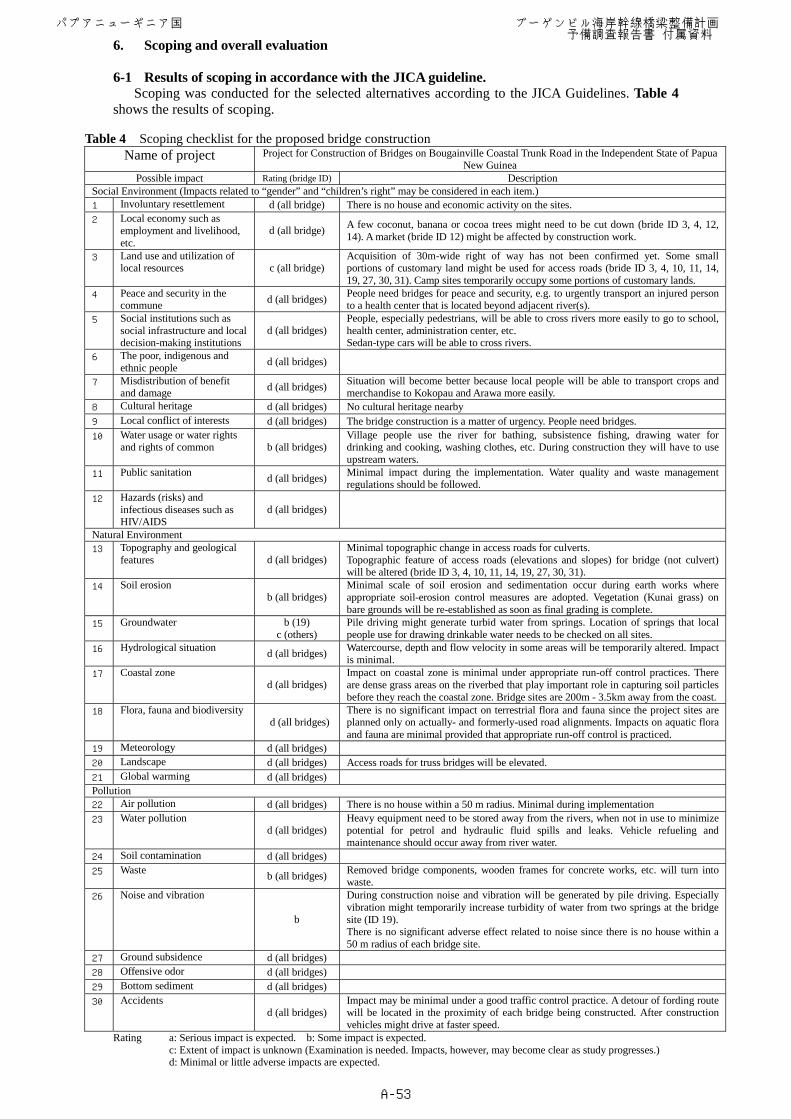
Scoping was conducted for the selected alternatives according to the JICA Guidelines. Table 4 shows the results of scoping.
Table 4 Scoping checklist for the proposed bridge construction Name of project Project for Construction of Bridges on Bougainville Coastal Trunk Road in the Independent State of Papua
New Guinea Possible impact Rating (bridge ID) Description
Social Environment (Impacts related to “gender” and “children’s right” may be considered in each item.) 1 Involuntary resettlement d (all bridge) There is no house and economic activity on the sites. 2 Local economy such as
employment and livelihood, etc.
d (all bridge) A few coconut, banana or cocoa trees might need to be cut down (bride ID 3, 4, 12, 14). A market (bride ID 12) might be affected by construction work.
3 Land use and utilization of local resources c (all bridge)
Acquisition of 30m-wide right of way has not been confirmed yet. Some small portions of customary land might be used for access roads (bride ID 3, 4, 10, 11, 14, 19, 27, 30, 31). Camp sites temporarily occupy some portions of customary lands.
4 Peace and security in the commune d (all bridges) People need bridges for peace and security, e.g. to urgently transport an injured person
to a health center that is located beyond adjacent river(s). 5 Social institutions such as
social infrastructure and local decision-making institutions
d (all bridges) People, especially pedestrians, will be able to cross rivers more easily to go to school, health center, administration center, etc. Sedan-type cars will be able to cross rivers.
6 The poor, indigenous and ethnic people d (all bridges)
7 Misdistribution of benefit and damage d (all bridges) Situation will become better because local people will be able to transport crops and
merchandise to Kokopau and Arawa more easily. 8 Cultural heritage d (all bridges) No cultural heritage nearby 9 Local conflict of interests d (all bridges) The bridge construction is a matter of urgency. People need bridges. 10 Water usage or water rights
and rights of common b (all bridges) Village people use the river for bathing, subsistence fishing, drawing water for drinking and cooking, washing clothes, etc. During construction they will have to use upstream waters.
11 Public sanitation d (all bridges) Minimal impact during the implementation. Water quality and waste management regulations should be followed.
12 Hazards (risks) and infectious diseases such as HIV/AIDS
d (all bridges)
Natural Environment 13 Topography and geological
features d (all bridges) Minimal topographic change in access roads for culverts. Topographic feature of access roads (elevations and slopes) for bridge (not culvert) will be altered (bride ID 3, 4, 10, 11, 14, 19, 27, 30, 31).
14 Soil erosion b (all bridges)
Minimal scale of soil erosion and sedimentation occur during earth works where appropriate soil-erosion control measures are adopted. Vegetation (Kunai grass) on bare grounds will be re-established as soon as final grading is complete.
15 Groundwater b (19) c (others)
Pile driving might generate turbid water from springs. Location of springs that local people use for drawing drinkable water needs to be checked on all sites.
16 Hydrological situation d (all bridges) Watercourse, depth and flow velocity in some areas will be temporarily altered. Impact is minimal.
17 Coastal zone d (all bridges)
Impact on coastal zone is minimal under appropriate run-off control practices. There are dense grass areas on the riverbed that play important role in capturing soil particles before they reach the coastal zone. Bridge sites are 200m - 3.5km away from the coast.
18 Flora, fauna and biodiversity d (all bridges)
There is no significant impact on terrestrial flora and fauna since the project sites are planned only on actually- and formerly-used road alignments. Impacts on aquatic flora and fauna are minimal provided that appropriate run-off control is practiced.
19 Meteorology d (all bridges) 20 Landscape d (all bridges) Access roads for truss bridges will be elevated. 21 Global warming d (all bridges) Pollution 22 Air pollution d (all bridges) There is no house within a 50 m radius. Minimal during implementation 23 Water pollution
d (all bridges) Heavy equipment need to be stored away from the rivers, when not in use to minimize potential for petrol and hydraulic fluid spills and leaks. Vehicle refueling and maintenance should occur away from river water.
24 Soil contamination d (all bridges) 25 Waste b (all bridges) Removed bridge components, wooden frames for concrete works, etc. will turn into
waste. 26 Noise and vibration
b
During construction noise and vibration will be generated by pile driving. Especially vibration might temporarily increase turbidity of water from two springs at the bridge site (ID 19). There is no significant adverse effect related to noise since there is no house within a 50 m radius of each bridge site.
27 Ground subsidence d (all bridges) 28 Offensive odor d (all bridges) 29 Bottom sediment d (all bridges) 30 Accidents
d (all bridges) Impact may be minimal under a good traffic control practice. A detour of fording route will be located in the proximity of each bridge being constructed. After construction vehicles might drive at faster speed.
Rating a: Serious impact is expected. b: Some impact is expected. c: Extent of impact is unknown (Examination is needed. Impacts, however, may become clear as study progresses.) d: Minimal or little adverse impacts are expected.
パプアニューギニア国 ブーゲンビル海岸幹線橋梁整備計画 予備調査報告書 付属資料
A-53
6-2 Overall evaluation The project is classified as category “B” according to the JICA Guidelines because of the
following reasons. - It has not been confirmed whether or not 30m-wide right of way for the proposed
project has already been acquired. - River water at the proposed project sites will become unavailable during construction. - Soil run-off might cause adverse impacts on environments in adjacent and downstream
areas unless an appropriate soil run-off control measure is adopted. 7 Stakeholder meeting
Implementation of the proposed project will cause some impacts, of which local people should be informed, although the impacts are expected to be minimal as explained above (6-2). Besides, the Government of Japan has been concerned about security situation during the implementation stage and conflict with local people about land use. Therefore, the JICA preliminary study team asked ABG to establish Community Coordination Committees that play key roles in settling any kind of problem between local people, project implementation organizations (ABG & DOW) and contractors and to hold stakeholder meetings to ask local residents’ opinions about the proposed project. The ABG and local communities have already selected Committee members for all (15) project sites, which consist of ABG staff, chief of clan, women’s representative, youth representative, land owner, church member, policeman, and so forth.
Two stakeholder meetings were held on Rawa 1 and Ururua sites inviting the Committee members and other local residents (non-committee members) on Sept. 1 and 10, respectively. There were no dissenting opinions about the proposed bridge construction for both sites. All attendees were keen that bridges would be constructed to eliminate the inconveniency (i.e. wet crossing). There were some local people’s concerns related to change in river water quality (Rawa 1) and temporal unavailability of spring water for drinkable water located close to the project site (Ururua) although these problems were at resolvable levels. Moreover, it was noted that local people look forward to having job opportunities related to the construction works.
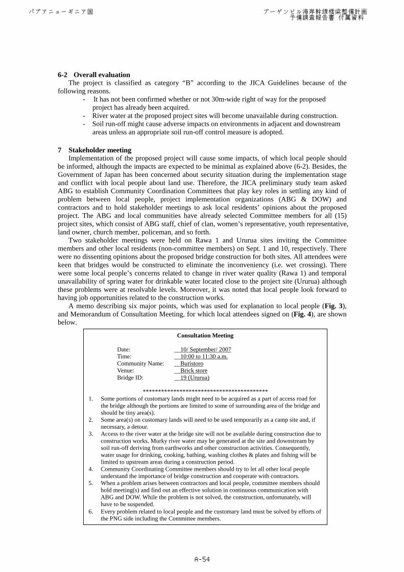
A memo describing six major points, which was used for explanation to local people (Fig. 3), and Memorandum of Consultation Meeting, for which local attendees signed on (Fig. 4), are shown below.
Consultation Meeting
Date: 10/ September/ 2007 Time: 10:00 to 11:30 a.m. Community Name: Buristoro Venue: Brick store Bridge ID: 19 (Ururua)
*****************************************
1. Some portions of customary lands might need to be acquired as a part of access road for the bridge although the portions are limited to some of surrounding area of the bridge and should be tiny area(s).
2. Some area(s) on customary lands will need to be used temporarily as a camp site and, if necessary, a detour.
3. Access to the river water at the bridge site will not be available during construction due to construction works. Murky river water may be generated at the site and downstream by soil run-off deriving from earthworks and other construction activities. Consequently, water usage for drinking, cooking, bathing, washing clothes & plates and fishing will be limited to upstream areas during a construction period.
4. Community Coordinating Committee members should try to let all other local people understand the importance of bridge construction and cooperate with contractors.
5. When a problem arises between contractors and local people, committee members should hold meeting(s) and find out an effective solution in continuous communication with ABG and DOW. While the problem is not solved, the construction, unfortunately, will have to be suspended.
6. Every problem related to local people and the customary land must be solved by efforts of the PNG side including the Committee members.
パプアニューギニア国 ブーゲンビル海岸幹線橋梁整備計画 予備調査報告書 付属資料
A-54
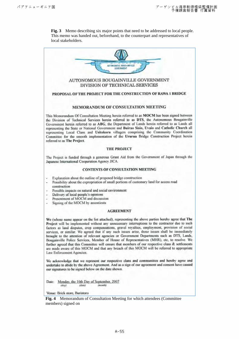
Fig. 3 Memo describing six major points that need to be addressed to local people. This memo was handed out, beforehand, to the counterpart and representatives of local stakeholders.
Fig. 4 Memorandum of Consultation Meeting for which attendees (Committee
members) signed on
パプアニューギニア国 ブーゲンビル海岸幹線橋梁整備計画 予備調査報告書 付属資料
A-55
Minutes of the stakeholders meetings held for both sites are inserted below. ==================================================================== Meeting for the project site Rawa 1 Date: September 1, 2007 Time: 10:00 to 11:30 a.m. Venue: Kuri Lodge, Buka No. of attendees: 11 local stake holders (incl. 3 women) and Mr. Simeon Itamai from ABG
(Attendees list is attached to the Memorandum of Consultation Meeting) Observers: 3 members of the JICA preliminary study team and a staff from the JICA-PNG
staff I. ABG explained the outline of the Proposed project of Rawa 1 bridge construction to the
members of Community Coordination Committee. II. All attendees hope earnestly that a bridge will be constructed. There were no dissenting
opinions about the proposed project of the construction of new Rawa 1 Bridge. III. One member expressed his hope that villagers will be able to have job opportunities with the
project to make up for their livelihoods. ABG and JICA replied that the project may give job opportunities although the job may be offered through a sub-contractor of the project.
IV. One female member expressed that construction of a bridge is a matter of urgency. A JICA member showed his appreciation of the attendance of females at the meeting because women’s opinions are influential for decision-making.
V. ABG and JICA explained potential environmental impacts as follows; 1) During the construction water from the construction site and near downstream
will not be unsuitable for drinking, cooking, washing clothes and bathing. 2) Odd smells due to auto emissions may be generated during the construction
works. 3) Fishing activities also will be affected by some extent of soil run-off. 4) The duration of above impacts will last approximately for 6 months. 5) During the coconuts piling, which may last approximately for 2 weeks,
vibrations and noises are generated. VI. The local people members expressed their opinions about the above potential environmental
impacts that they will use water upstream for domestic use and understand the inconveniences caused by the bridge construction and their priority is to have a bridge in Rawa 1 site. One member expressed his concern about the contamination of river water by chemicals during construction. The ABG and JICA study team replied that discharge of wastes to the river must be strictly controlled in the accordance with the national laws/regulations.
VII. ABG explained the envisioned location of a campsite and requested local people to understand that contractor will use the site during construction works. The local people member accepted the request because the priority is to have a bridge as soon as possible.
VIII. Contents of MOU were explained. Attendees that agreed to the MOU signed on the attendee list as the evidence of agreement.
IX. All attendees and observers shook each other’s hands and the meeting was adjourned.
====================================================================
パプアニューギニア国 ブーゲンビル海岸幹線橋梁整備計画 予備調査報告書 付属資料
A-56
Meeting for the project site Ururua Date: September 10, 2007 Time: 10:00 to 11:30 a.m. Bridge (ID): Ururua (19) Venue: Brick store, Buristoro No. of attendees: 23 villagers including 9 Community Coordinating Committee members
including 2 ladies Mr. Simeon Itamai from ABG (Attendees list is attached to the Memorandum of Consultation Meeting)
Mr. Hideki Yukihira, Mr. Hideo Matsushima (members of the JICA preliminary study team)
I. ABG explained the outline of the proposed project of bridge construction at Ururua to the
members of Community Coordination Committee. II. ABG explained six major points that local people should know about impacts of the project.
(see Fig. 3) III. A woman said, “We use river water at the bridge site for washing and bathing. We go
upstream during the construction of bridge.” JICA explained that the construction work will use a range of area, approximately 10m upstream to 10m downstream from the bridge.
IV. The same lady said, “A spring that we draw drinkable water is located 10 m downstream from the site.” JICA added information that pile driving work might generate turbid water from the spring. The woman said there is another spring about 20m upstream from the site. JICA said, “The work probably does not cause serious problem since there is a spring 20 m upstream, however the location of spring needs to be checked before the work and water quality of the springs should be monitored during the work.”
V. A man asked whether the construction of new bridge is planned on a new alignment. ABG answered, “It is planned on the same alignment where the demolished bridge is located.”
VI. A land owner suggested that a camp site may be located on the Buka side from the bridge since Arawa side is occupied by plantations and has no enough space. ABG agreed with this. He said there is no problem in this project proposal and he will support it. He agreed about the use of his land that covers the project site.
VII. JICA asked to the attendees about the information heard from the Deputy Secretary of DOW Headquarters that a road maintenance contractor was threatened by local people and robbed of money when working in Ururua. Regarding this information an attendee (man) gave information that the incident happened (in 1996) because the contractor, “Effective Constructor”, did not make payment to its employees. The attendee and some more attendees (men) said that the incident was an internal problem of the contractor (i.e. between employer and employees), but not a problem between this community people and contactor. They concluded that the problem was caused by the contractor, but not community people.
VIII. A man asked whether local people can have job opportunities as local workers from the project. ABG replied, “The decision will be made by contractor. JICA cannot give any commitment about this matter.”
IX. ABG and JICA concluded that there is no dissenting opinion about the proposed project and expressed their hope that local people will support the project.
X. The attendees from the site said that there is no dissenting opinion and they will support the project. All attendees hope earnestly that a bridge will be constructed.
XI. The meeting was adjourned. ====================================================================
After the JICA Preliminary Study, ABG continued to hold stakeholder meetings on the remaining
13 sites and has already reported to JICA about results of the meetings. The results are all favorable, at this phase, as all participants have expressed their understanding and cooperation about the proposed project.
パプアニューギニア国 ブーゲンビル海岸幹線橋梁整備計画 予備調査報告書 付属資料
A-57
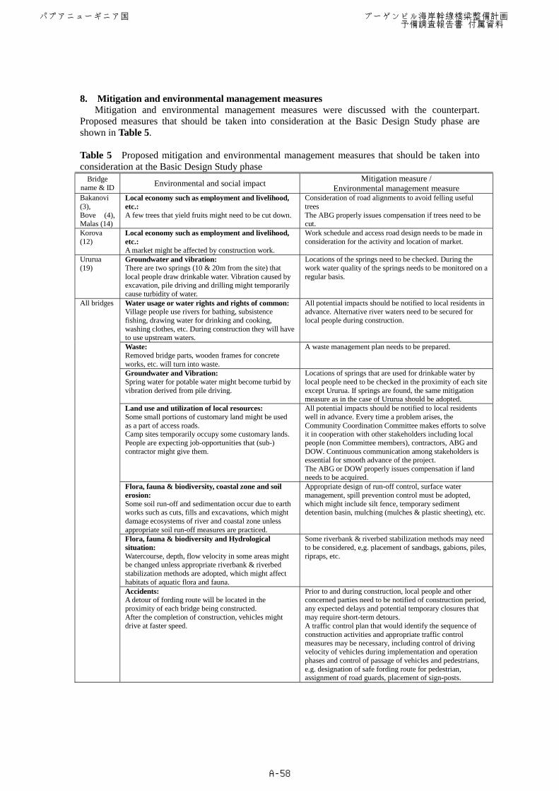
8. Mitigation and environmental management measures Mitigation and environmental management measures were discussed with the counterpart.
Proposed measures that should be taken into consideration at the Basic Design Study phase are shown in Table 5. Table 5 Proposed mitigation and environmental management measures that should be taken into consideration at the Basic Design Study phase
Bridge name & ID Environmental and social impact Mitigation measure /
Environmental management measure Bakanovi (3), Bove (4), Malas (14)
Local economy such as employment and livelihood, etc.: A few trees that yield fruits might need to be cut down.
Consideration of road alignments to avoid felling useful trees The ABG properly issues compensation if trees need to be cut.
Korova (12)
Local economy such as employment and livelihood, etc.: A market might be affected by construction work.
Work schedule and access road design needs to be made in consideration for the activity and location of market.
Ururua (19)
Groundwater and vibration: There are two springs (10 & 20m from the site) that local people draw drinkable water. Vibration caused by excavation, pile driving and drilling might temporarily cause turbidity of water.
Locations of the springs need to be checked. During the work water quality of the springs needs to be monitored on a regular basis.
Water usage or water rights and rights of common: Village people use rivers for bathing, subsistence fishing, drawing water for drinking and cooking, washing clothes, etc. During construction they will have to use upstream waters.
All potential impacts should be notified to local residents in advance. Alternative river waters need to be secured for local people during construction.
Waste: Removed bridge parts, wooden frames for concrete works, etc. will turn into waste.
A waste management plan needs to be prepared.
Groundwater and Vibration: Spring water for potable water might become turbid by vibration derived from pile driving.
Locations of springs that are used for drinkable water by local people need to be checked in the proximity of each site except Ururua. If springs are found, the same mitigation measure as in the case of Ururua should be adopted.
Land use and utilization of local resources: Some small portions of customary land might be used as a part of access roads. Camp sites temporarily occupy some customary lands. People are expecting job-opportunities that (sub-) contractor might give them.
All potential impacts should be notified to local residents well in advance. Every time a problem arises, the Community Coordination Committee makes efforts to solve it in cooperation with other stakeholders including local people (non Committee members), contractors, ABG and DOW. Continuous communication among stakeholders is essential for smooth advance of the project. The ABG or DOW properly issues compensation if land needs to be acquired.
Flora, fauna & biodiversity, coastal zone and soil erosion: Some soil run-off and sedimentation occur due to earth works such as cuts, fills and excavations, which might damage ecosystems of river and coastal zone unless appropriate soil run-off measures are practiced.
Appropriate design of run-off control, surface water management, spill prevention control must be adopted, which might include silt fence, temporary sediment detention basin, mulching (mulches & plastic sheeting), etc.
Flora, fauna & biodiversity and Hydrological situation: Watercourse, depth, flow velocity in some areas might be changed unless appropriate riverbank & riverbed stabilization methods are adopted, which might affect habitats of aquatic flora and fauna.
Some riverbank & riverbed stabilization methods may need to be considered, e,g. placement of sandbags, gabions, piles, ripraps, etc.
All bridges
Accidents: A detour of fording route will be located in the proximity of each bridge being constructed. After the completion of construction, vehicles might drive at faster speed.
Prior to and during construction, local people and other concerned parties need to be notified of construction period, any expected delays and potential temporary closures that may require short-term detours. A traffic control plan that would identify the sequence of construction activities and appropriate traffic control measures may be necessary, including control of driving velocity of vehicles during implementation and operation phases and control of passage of vehicles and pedestrians, e.g. designation of safe fording route for pedestrian, assignment of road guards, placement of sign-posts.
パプアニューギニア国 ブーゲンビル海岸幹線橋梁整備計画 予備調査報告書 付属資料
A-58
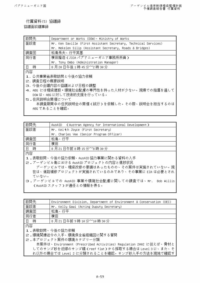
協議面談議事録 訪問先 Department or Works (DOW)、Ministry of Works
面談者 Mr. Ken Saville (First Assistant Secretary, Technical Services)
Mr. Mekelen Silip (Assistant Secretary, Roads & Bridges)
調査団 松島秀夫、行平英基
同行者 横田隆浩(JICA パプアニューギニア事務所所員)
Mr. Tony Ombo (Administration Manager)
日 時 8 月 20 日午後 1時 45 分~2時 30 分
内容
1. 公共事業省表敬訪問と今後の協力依頼
2. 調査日程の概要説明
3. 今後の会議内容の協議および日程の調整
4. ABG には橋梁建設・環境社会配慮の専門性を持った人材が少ない。現場での指導を通して
DOW は、ABG に対して技術的支援を行っている。
5.住民説明会開催について
本調査期間中の住民説明会の開催(試行)を依頼した。その際、説明会を担当するのは
ABG であることを確認。
訪問先 AusAID (Austran Agency for International Development)
面談者 Mr. Keith Joyce (First Secretary)
Mr. Charles Vee (Senior Program Officer)
調査団 松島、行平
同行者 横田
日 時 8 月 21 日午前 8時 15 分~8時 30 分
内容
1.表敬訪問、今後の協力依頼、AusAID 協力事業に関わる資料の入手
2.ブーゲンビル島における AusAID プロジェクトの内容と進捗状況
ブーゲンビルでは、橋梁改修の要請はあったものの、その案件は実施されていない。現
在は、道路補修プロジェクトが実施されているのみであり、その事業に EIA は必要とされ
ていない。
3.ブーゲンビルでの AusAID 事業や環境社会配慮に関しての調査では、Mr. Bob Willis
(AusAID スタッフ)が適任との情報を得る。
訪問先 Environment Division, Department of Environment & Conservation (DEC)
面談者 Mr. Kelly Gawi (Acting Duputy Secretary)
調査団 松島、行平
同行者 横田
日 時 8 月 21 日午前 9時 10 分~10時 30 分
内容
1.表敬訪問、今後の協力依頼
2.環境関連法令の入手、環境保全省組織図に関する質問
2.本プロジェクト案件の環境カテゴリー分類
本案件は、Environment (Prescribed Activities) Regulation 2002 に従えば、骨材と
してのサンゴ砂を近縁のサンゴ礁(reef flat)から採取する場合は Level 3 に、また、そ
れ以外の場合では Level 2 に分類されることを確認。サンゴ砂入手の方法を現地で確認す
パプアニューギニア国 ブーゲンビル海岸幹線橋梁整備計画 予備調査報告書 付属資料
A-59
付属資料(5) 協議録
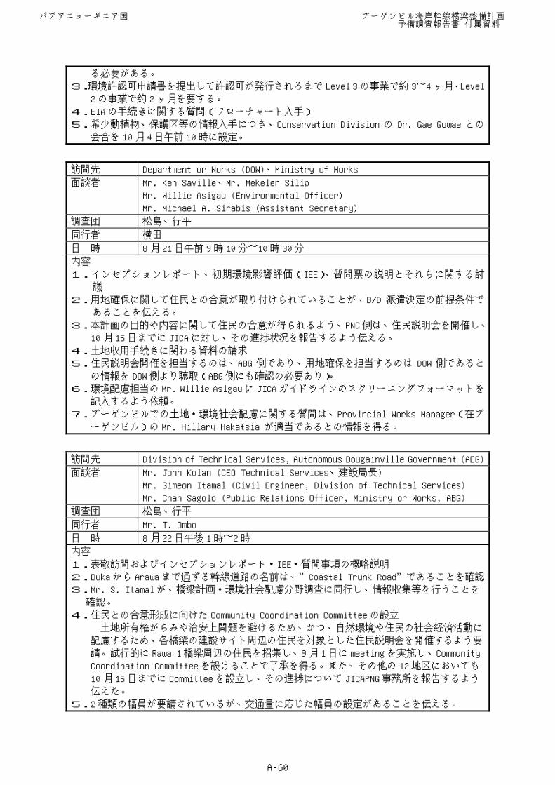
る必要がある。
3.環境許認可申請書を提出して許認可が発行されるまで Level 3 の事業で約 3~4ヶ月、Level
2 の事業で約 2ヶ月を要する。
4.EIA の手続きに関する質問(フローチャート入手)
5.希少動植物、保護区等の情報入手につき、Conservation Division の Dr. Gae Gowae との
会合を 10月 4日午前 10時に設定。
訪問先 Department or Works (DOW)、Ministry of Works
面談者 Mr. Ken Saville、Mr. Mekelen Silip
Mr. Willie Asigau (Environmental Officer)
Mr. Michael A. Sirabis (Assistant Secretary)
調査団 松島、行平
同行者 横田
日 時 8 月 21 日午前 9時 10 分~10時 30 分
内容
1.インセプションレポート、初期環境影響評価(IEE)、質問票の説明とそれらに関する討
議
2.用地確保に関して住民との合意が取り付けられていることが、B/D 派遣決定の前提条件で
あることを伝える。
3.本計画の目的や内容に関して住民の合意が得られるよう、PNG 側は、住民説明会を開催し、
10 月 15 日までに JICA に対し、その進捗状況を報告するよう伝える。
4.土地収用手続きに関わる資料の請求
5.住民説明会開催を担当するのは、ABG 側であり、用地確保を担当するのは DOW 側であると
の情報を DOW 側より聴取(ABG 側にも確認の必要あり)。
6.環境配慮担当の Mr. Willie Asigau に JICA ガイドラインのスクリーニングフォーマットを
記入するよう依頼。
7.ブーゲンビルでの土地・環境社会配慮に関する質問は、Provincial Works Manager(在ブ
ーゲンビル)の Mr. Hillary Hakatsia が適当であるとの情報を得る。
訪問先 Division of Technical Services, Autonomous Bougainville Government (ABG)
面談者 Mr. John Kolan (CEO Technical Services、建設局長)
Mr. Simeon Itamal (Civil Engineer, Division of Technical Services)
Mr. Chan Sagolo (Public Relations Officer, Ministry or Works, ABG)
調査団 松島、行平
同行者 Mr. T. Ombo
日 時 8 月 22 日午後 1時~2時
内容
1.表敬訪問およびインセプションレポート・IEE・質問事項の概略説明
2.Buka から Arawa まで通ずる幹線道路の名前は、”Coastal Trunk Road”であることを確認
3.Mr. S. Itamal が、橋梁計画・環境社会配慮分野調査に同行し、情報収集等を行うことを
確認。
4.住民との合意形成に向けた Community Coordination Committee の設立
土地所有権がらみや治安上問題を避けるため、かつ、自然環境や住民の社会経済活動に
配慮するため、各橋梁の建設サイト周辺の住民を対象とした住民説明会を開催するよう要
請。試行的に Rawa 1 橋梁周辺の住民を招集し、9月 1日に meeting を実施し、Community
Coordination Committee を設けることで了承を得る。また、その他の 12地区においても
10 月 15 日までに Committee を設立し、その進捗について JICAPNG 事務所を報告するよう
伝えた。
5.2種類の幅員が要請されているが、交通量に応じた幅員の設定があることを伝える。
パプアニューギニア国 ブーゲンビル海岸幹線橋梁整備計画 予備調査報告書 付属資料
A-60
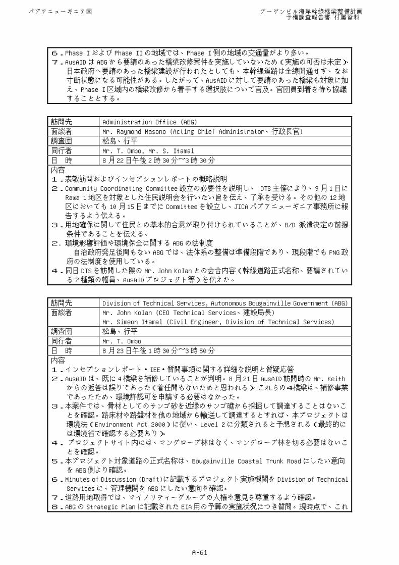
6.Phase I および Phase II の地域では、Phase I 側の地域の交通量がより多い。
7.AusAID は ABG から要請のあった橋梁改修案件を実施していないため(実施の可否は未定)、
日本政府へ要請のあった橋梁建設が行われたとしても、本幹線道路は全線開通せず、なお
寸断状態になる可能性がある。したがって、AusAID に対して要請のあった橋梁も対象に加
え、Phase I 区域内の橋梁改修から着手する選択肢について言及。官団員到着を待ち協議
することとする。
訪問先 Administration Office (ABG)
面談者 Mr. Raymond Masono (Acting Chief Administrator、行政長官)
調査団 松島、行平
同行者 Mr. T. Ombo, Mr. S. Itamal
日 時 8 月 22 日午後 2時 30 分~3時 30 分
内容
1.表敬訪問およびインセプションレポートの概略説明
2.Community Coordinating Committee 設立の必要性を説明し、 DTS 主催により、9月 1日に
Rawa 1 地区を対象とした住民説明会を行いたい旨を伝え、了承を受ける。その他の 12 地
区においても 10 月 15 日までに Committee を設立し、JICA パプアニューギニア事務所に報
告するよう伝える。
3.用地確保に関して住民との基本的合意が取り付けられていることが、B/D 派遣決定の前提
条件であることを伝える。
2. 環境影響評価や環境保全に関する ABG の法制度
自治政府発足後間もない ABG では、法体系の整備は準備段階であり、現段階でも PNG 政
府の法制度を使用している。
4.同日 DTS を訪問した際の Mr. John Kolan との会合内容(幹線道路正式名称、要請されてい
る 2種類の幅員、AusAID プロジェクト等)を伝えた。
訪問先 Division of Technical Services, Autonomous Bougainville Government (ABG)
面談者 Mr. John Kolan (CEO Technical Services、建設局長)
Mr. Simeon Itamal (Civil Engineer, Division of Technical Services)
調査団 松島、行平
同行者 Mr. T. Ombo
日 時 8 月 23 日午後 1時 30 分~3時 50 分
内容
1.インセプションレポート・IEE・質問事項に関する詳細な説明と質疑応答
2.AusAID は、既に 4橋梁を補修していることが判明。8月 21日 AusAID 訪問時の Mr. Keith
からの返答は誤りであった(着任間もないためと思われる)。これらの4橋梁は、補修事業
であったため、環境許認可を申請する必要はなかった。
3.本案件では、骨材としてのサンゴ砂を近縁のサンゴ礁から採掘して調達することはないこ
とを確認。路床材や路盤材を他の地域から輸送して調達するとすれば、本プロジェクトは
環境法(Environment Act 2000)に従い、Level 2 に分類されると予想される(最終的に
は環境省で確認する必要あり)。
4. プロジェクトサイト内には、マングローブ林はなく、マングローブ林を切る必要はないこ
とを確認。
5.本プロジェクト対象道路の正式名称は、Bougainville Coastal Trunk Road にしたい意向
を ABG 側より確認。
6.Minutes of Discussion (Draft)に記載するプロジェクト実施機関を Division of Technical
Services に、管理機関を ABG にしたい意向を確認。
7.道路用地取得では、マイノリティーグループの人権や意見を尊重するよう確認。
8.ABG の Strategic Plan に記載された EIA 用の予算の実施状況につき質問。現時点で、これ
パプアニューギニア国 ブーゲンビル海岸幹線橋梁整備計画 予備調査報告書 付属資料
A-61
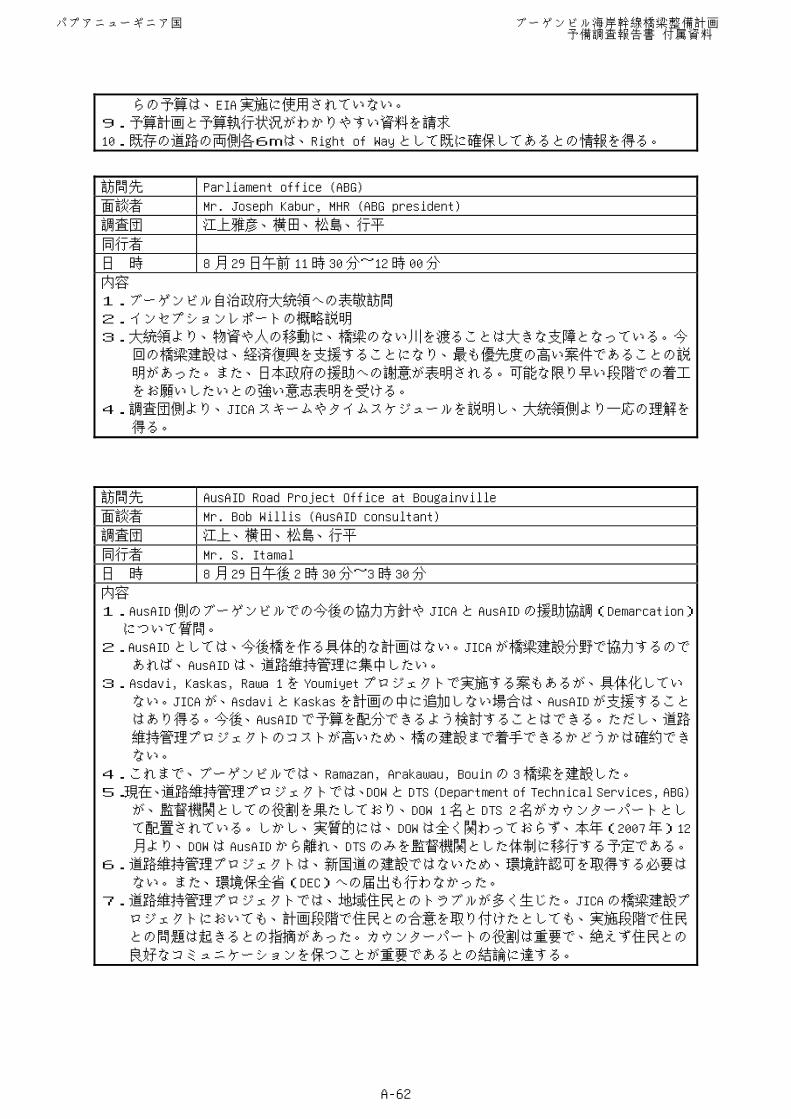
らの予算は、EIA 実施に使用されていない。
9.予算計画と予算執行状況がわかりやすい資料を請求
10.既存の道路の両側各6mは、Right of Way として既に確保してあるとの情報を得る。
訪問先 Parliament office (ABG)
面談者 Mr. Joseph Kabur, MHR (ABG president)
調査団 江上雅彦、横田、松島、行平
同行者
日 時 8 月 29 日午前 11 時 30 分~12時 00 分
内容
1.ブーゲンビル自治政府大統領への表敬訪問
2.インセプションレポートの概略説明
3.大統領より、物資や人の移動に、橋梁のない川を渡ることは大きな支障となっている。今
回の橋梁建設は、経済復興を支援することになり、最も優先度の高い案件であることの説
明があった。また、日本政府の援助への謝意が表明される。可能な限り早い段階での着工
をお願いしたいとの強い意志表明を受ける。
4.調査団側より、JICA スキームやタイムスケジュールを説明し、大統領側より一応の理解を
得る。
訪問先 AusAID Road Project Office at Bougainville
面談者 Mr. Bob Willis (AusAID consultant)
調査団 江上、横田、松島、行平
同行者 Mr. S. Itamal
日 時 8 月 29 日午後 2時 30 分~3時 30 分
内容
1.AusAID 側のブーゲンビルでの今後の協力方針や JICA と AusAID の援助協調(Demarcation)
について質問。
2.AusAID としては、今後橋を作る具体的な計画はない。JICA が橋梁建設分野で協力するので
あれば、AusAID は、道路維持管理に集中したい。
3.Asdavi, Kaskas, Rawa 1 を Youmiyet プロジェクトで実施する案もあるが、具体化してい
ない。JICA が、Asdavi と Kaskas を計画の中に追加しない場合は、AusAID が支援すること
はあり得る。今後、AusAID で予算を配分できるよう検討することはできる。ただし、道路
維持管理プロジェクトのコストが高いため、橋の建設まで着手できるかどうかは確約でき
ない。
4.これまで、ブーゲンビルでは、Ramazan, Arakawau, Bouin の 3 橋梁を建設した。
5.現在、道路維持管理プロジェクトでは、DOW と DTS (Department of Technical Services, ABG)
が、監督機関としての役割を果たしており、DOW 1 名と DTS 2 名がカウンターパートとし
て配置されている。しかし、実質的には、DOW は全く関わっておらず、本年(2007 年)12
月より、DOW は AusAID から離れ、DTS のみを監督機関とした体制に移行する予定である。
6.道路維持管理プロジェクトは、新国道の建設ではないため、環境許認可を取得する必要は
ない。また、環境保全省(DEC)への届出も行わなかった。
7.道路維持管理プロジェクトでは、地域住民とのトラブルが多く生じた。JICA の橋梁建設プ
ロジェクトにおいても、計画段階で住民との合意を取り付けたとしても、実施段階で住民
との問題は起きるとの指摘があった。カウンターパートの役割は重要で、絶えず住民との
良好なコミュニケーションを保つことが重要であるとの結論に達する。
パプアニューギニア国 ブーゲンビル海岸幹線橋梁整備計画 予備調査報告書 付属資料
A-62
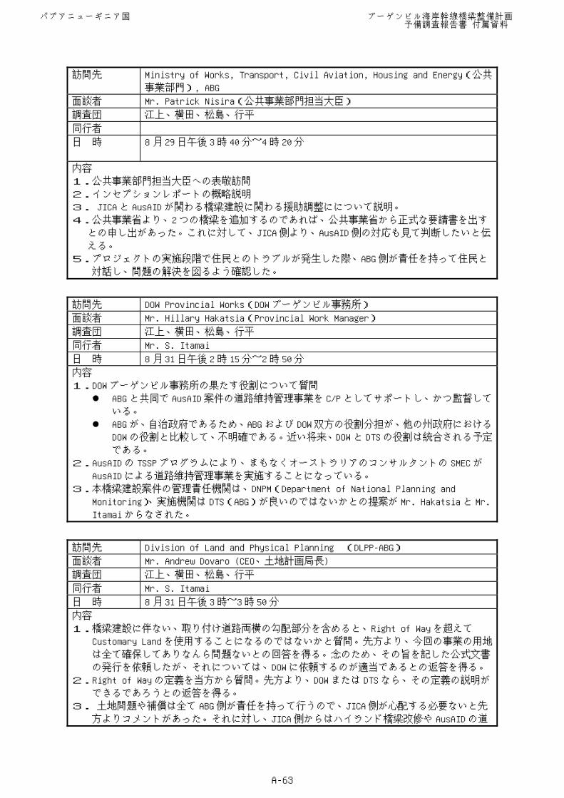
訪問先 Ministry of Works, Transport, Civil Aviation, Housing and Energy(公共
事業部門), ABG
面談者 Mr. Patrick Nisira(公共事業部門担当大臣)
調査団 江上、横田、松島、行平
同行者
日 時 8 月 29 日午後 3時 40 分~4時 20 分
内容
1.公共事業部門担当大臣への表敬訪問
2.インセプションレポートの概略説明
3. JICA と AusAID が関わる橋梁建設に関わる援助調整にについて説明。
4.公共事業省より、2つの橋梁を追加するのであれば、公共事業省から正式な要請書を出す
との申し出があった。これに対して、JICA 側より、AusAID 側の対応も見て判断したいと伝
える。
5.プロジェクトの実施段階で住民とのトラブルが発生した際、ABG 側が責任を持って住民と
対話し、問題の解決を図るよう確認した。
訪問先 DOW Provincial Works(DOW ブーゲンビル事務所)
面談者 Mr. Hillary Hakatsia(Provincial Work Manager)
調査団 江上、横田、松島、行平
同行者 Mr. S. Itamai
日 時 8 月 31 日午後 2時 15 分~2時 50 分
内容
1.DOW ブーゲンビル事務所の果たす役割について質問
ABG と共同で AusAID 案件の道路維持管理事業を C/P としてサポートし、かつ監督している。
ABG が、自治政府であるため、ABG および DOW 双方の役割分担が、他の州政府におけるDOW の役割と比較して、不明確である。近い将来、DOW と DTS の役割は統合される予定
である。
2.AusAID の TSSP プログラムにより、まもなくオーストラリアのコンサルタントの SMEC が
AusAID による道路維持管理事業を実施することになっている。
3.本橋梁建設案件の管理責任機関は、DNPM(Department of National Planning and
Monitoring)、実施機関は DTS(ABG)が良いのではないかとの提案が Mr. Hakatsia と Mr.
Itamai からなされた。
訪問先 Division of Land and Physical Planning (DLPP-ABG)
面談者 Mr. Andrew Dovaro (CEO、土地計画局長)
調査団 江上、横田、松島、行平
同行者 Mr. S. Itamai
日 時 8 月 31 日午後 3時~3時 50 分
内容
1.橋梁建設に伴ない、取り付け道路両横の勾配部分を含めると、Right of Way を超えて
Customary Land を使用することになるのではないかと質問。先方より、今回の事業の用地
は全て確保してありなんら問題ないとの回答を得る。念のため、その旨を記した公式文書
の発行を依頼したが、それについては、DOW に依頼するのが適当であるとの返答を得る。
2.Right of Way の定義を当方から質問。先方より、DOW または DTS なら、その定義の説明が
できるであろうとの返答を得る。
3. 土地問題や補償は全て ABG 側が責任を持って行うので、JICA 側が心配する必要ないと先
方よりコメントがあった。それに対し、JICA 側からはハイランド橋梁改修や AusAID の道
パプアニューギニア国 ブーゲンビル海岸幹線橋梁整備計画 予備調査報告書 付属資料
A-63
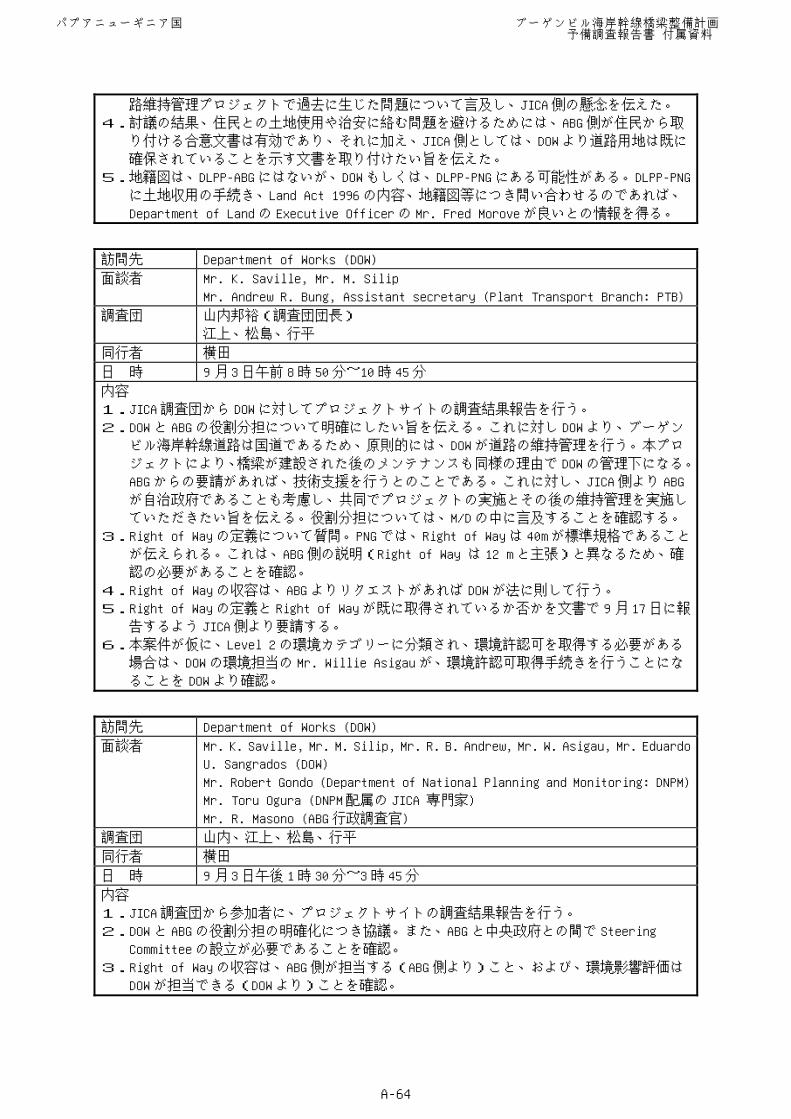
路維持管理プロジェクトで過去に生じた問題について言及し、JICA 側の懸念を伝えた。
4.討議の結果、住民との土地使用や治安に絡む問題を避けるためには、ABG 側が住民から取
り付ける合意文書は有効であり、それに加え、JICA 側としては、DOW より道路用地は既に
確保されていることを示す文書を取り付けたい旨を伝えた。
5.地籍図は、DLPP-ABG にはないが、DOW もしくは、DLPP-PNG にある可能性がある。DLPP-PNG
に土地収用の手続き、Land Act 1996 の内容、地籍図等につき問い合わせるのであれば、
Department of Land の Executive Officer の Mr. Fred Morove が良いとの情報を得る。
訪問先 Department of Works (DOW)
面談者 Mr. K. Saville, Mr. M. Silip
Mr. Andrew R. Bung, Assistant secretary (Plant Transport Branch: PTB)
調査団 山内邦裕(調査団団長)
江上、松島、行平
同行者 横田
日 時 9 月 3日午前 8時 50 分~10 時 45 分
内容
1.JICA 調査団から DOW に対してプロジェクトサイトの調査結果報告を行う。
2.DOW と ABG の役割分担について明確にしたい旨を伝える。これに対し DOW より、ブーゲン
ビル海岸幹線道路は国道であるため、原則的には、DOW が道路の維持管理を行う。本プロ
ジェクトにより、橋梁が建設された後のメンテナンスも同様の理由で DOW の管理下になる。
ABG からの要請があれば、技術支援を行うとのことである。これに対し、JICA 側より ABG
が自治政府であることも考慮し、共同でプロジェクトの実施とその後の維持管理を実施し
ていただきたい旨を伝える。役割分担については、M/D の中に言及することを確認する。
3.Right of Way の定義について質問。PNG では、Right of Way は 40m が標準規格であること
が伝えられる。これは、ABG 側の説明(Right of Way は 12 m と主張)と異なるため、確
認の必要があることを確認。
4.Right of Way の収容は、ABG よりリクエストがあれば DOW が法に則して行う。
5.Right of Way の定義と Right of Way が既に取得されているか否かを文書で 9月 17 日に報
告するよう JICA 側より要請する。
6.本案件が仮に、Level 2 の環境カテゴリーに分類され、環境許認可を取得する必要がある
場合は、DOW の環境担当の Mr. Willie Asigau が、環境許認可取得手続きを行うことにな
ることを DOW より確認。
訪問先 Department of Works (DOW)
面談者 Mr. K. Saville, Mr. M. Silip, Mr. R. B. Andrew, Mr. W. Asigau, Mr. Eduardo
U. Sangrados (DOW)
Mr. Robert Gondo (Department of National Planning and Monitoring: DNPM)
Mr. Toru Ogura (DNPM 配属の JICA 専門家)
Mr. R. Masono (ABG 行政調査官)
調査団 山内、江上、松島、行平
同行者 横田
日 時 9 月 3日午後 1時 30 分~3時 45 分
内容
1.JICA 調査団から参加者に、プロジェクトサイトの調査結果報告を行う。
2.DOW と ABG の役割分担の明確化につき協議。また、ABG と中央政府との間で Steering
Committee の設立が必要であることを確認。
3.Right of Way の収容は、ABG 側が担当する(ABG 側より)こと、および、環境影響評価は
DOW が担当できる(DOW より)ことを確認。
パプアニューギニア国 ブーゲンビル海岸幹線橋梁整備計画 予備調査報告書 付属資料
A-64
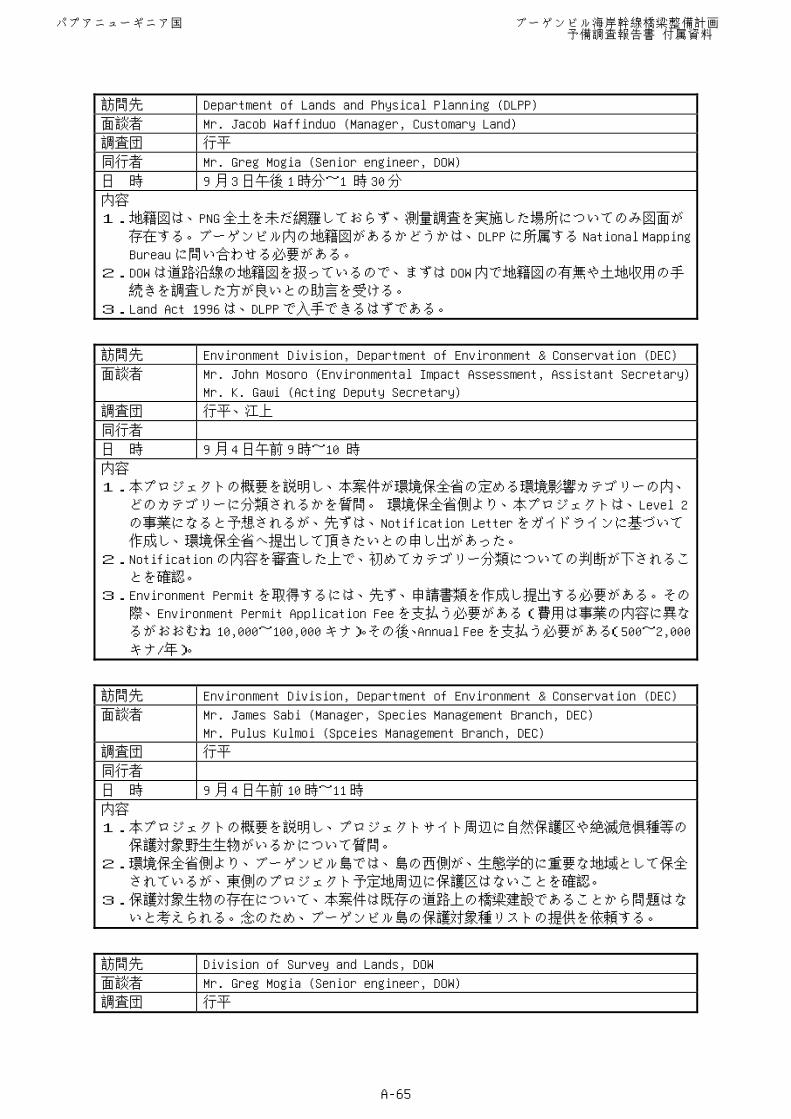
訪問先 Department of Lands and Physical Planning (DLPP)
面談者 Mr. Jacob Waffinduo (Manager, Customary Land)
調査団 行平
同行者 Mr. Greg Mogia (Senior engineer, DOW)
日 時 9 月 3日午後 1時分~1 時 30 分
内容
1.地籍図は、PNG 全土を未だ網羅しておらず、測量調査を実施した場所についてのみ図面が
存在する。ブーゲンビル内の地籍図があるかどうかは、DLPP に所属する National Mapping
Bureau に問い合わせる必要がある。
2.DOW は道路沿線の地籍図を扱っているので、まずは DOW 内で地籍図の有無や土地収用の手
続きを調査した方が良いとの助言を受ける。
3.Land Act 1996 は、DLPP で入手できるはずである。
訪問先 Environment Division, Department of Environment & Conservation (DEC)
面談者 Mr. John Mosoro (Environmental Impact Assessment, Assistant Secretary)
Mr. K. Gawi (Acting Deputy Secretary)
調査団 行平、江上
同行者
日 時 9 月 4日午前 9時~10 時
内容
1.本プロジェクトの概要を説明し、本案件が環境保全省の定める環境影響カテゴリーの内、
どのカテゴリーに分類されるかを質問。 環境保全省側より、本プロジェクトは、Level 2
の事業になると予想されるが、先ずは、Notification Letter をガイドラインに基づいて
作成し、環境保全省へ提出して頂きたいとの申し出があった。
2.Notification の内容を審査した上で、初めてカテゴリー分類についての判断が下されるこ
とを確認。
3.Environment Permit を取得するには、先ず、申請書類を作成し提出する必要がある。その
際、Environment Permit Application Fee を支払う必要がある(費用は事業の内容に異な
るがおおむね 10,000~100,000 キナ)。その後、Annual Fee を支払う必要がある(500~2,000
キナ/年)。
訪問先 Environment Division, Department of Environment & Conservation (DEC)
面談者 Mr. James Sabi (Manager, Species Management Branch, DEC)
Mr. Pulus Kulmoi (Spceies Management Branch, DEC)
調査団 行平
同行者
日 時 9 月 4日午前 10 時~11時
内容
1.本プロジェクトの概要を説明し、プロジェクトサイト周辺に自然保護区や絶滅危惧種等の
保護対象野生生物がいるかについて質問。
2.環境保全省側より、ブーゲンビル島では、島の西側が、生態学的に重要な地域として保全
されているが、東側のプロジェクト予定地周辺に保護区はないことを確認。
3.保護対象生物の存在について、本案件は既存の道路上の橋梁建設であることから問題はな
いと考えられる。念のため、ブーゲンビル島の保護対象種リストの提供を依頼する。
訪問先 Division of Survey and Lands, DOW
面談者 Mr. Greg Mogia (Senior engineer, DOW)
調査団 行平
パプアニューギニア国 ブーゲンビル海岸幹線橋梁整備計画 予備調査報告書 付属資料
A-65
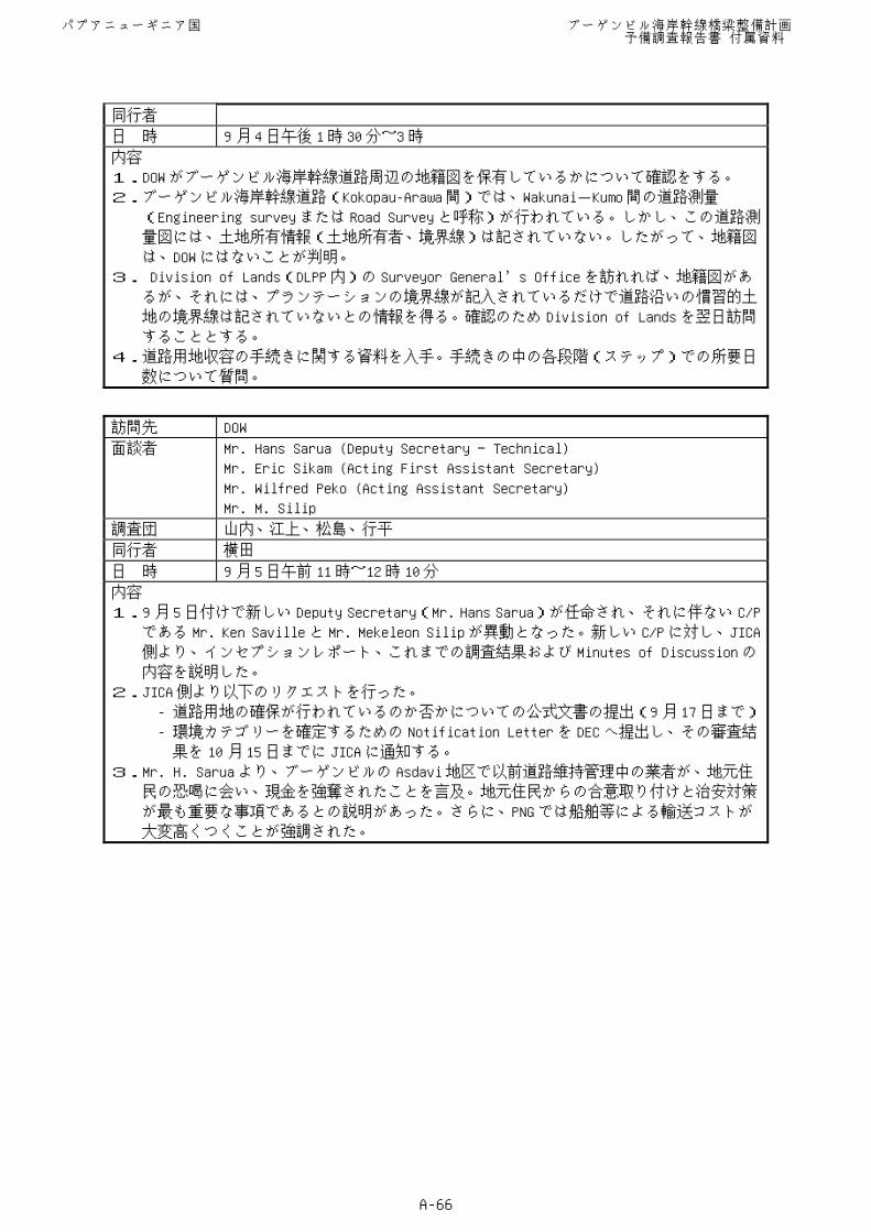
同行者
日 時 9 月 4日午後 1時 30 分~3時
内容
1.DOW がブーゲンビル海岸幹線道路周辺の地籍図を保有しているかについて確認をする。
2.ブーゲンビル海岸幹線道路(Kokopau-Arawa 間)では、Wakunai-Kumo 間の道路測量
(Engineering survey または Road Survey と呼称)が行われている。しかし、この道路測
量図には、土地所有情報(土地所有者、境界線)は記されていない。したがって、地籍図
は、DOW にはないことが判明。
3. Division of Lands(DLPP 内)の Surveyor General’s Office を訪れれば、地籍図があ
るが、それには、プランテーションの境界線が記入されているだけで道路沿いの慣習的土
地の境界線は記されていないとの情報を得る。確認のため Division of Lands を翌日訪問
することとする。
4.道路用地収容の手続きに関する資料を入手。手続きの中の各段階(ステップ)での所要日
数について質問。
訪問先 DOW
面談者 Mr. Hans Sarua (Deputy Secretary Technical)
Mr. Eric Sikam (Acting First Assistant Secretary)
Mr. Wilfred Peko (Acting Assistant Secretary)
Mr. M. Silip
調査団 山内、江上、松島、行平
同行者 横田
日 時 9 月 5日午前 11 時~12時 10 分
内容
1.9月 5日付けで新しい Deputy Secretary(Mr. Hans Sarua)が任命され、それに伴ない C/P
である Mr. Ken Saville と Mr. Mekeleon Silip が異動となった。新しい C/P に対し、JICA
側より、インセプションレポート、これまでの調査結果および Minutes of Discussion の
内容を説明した。
2.JICA 側より以下のリクエストを行った。
- 道路用地の確保が行われているのか否かについての公式文書の提出(9月 17日まで)
- 環境カテゴリーを確定するための Notification Letter を DEC へ提出し、その審査結
果を 10 月 15 日までに JICA に通知する。
3.Mr. H. Sarua より、ブーゲンビルの Asdavi 地区で以前道路維持管理中の業者が、地元住
民の恐喝に会い、現金を強奪されたことを言及。地元住民からの合意取り付けと治安対策
が最も重要な事項であるとの説明があった。さらに、PNG では船舶等による輸送コストが
大変高くつくことが強調された。
パプアニューギニア国 ブーゲンビル海岸幹線橋梁整備計画 予備調査報告書 付属資料
A-66
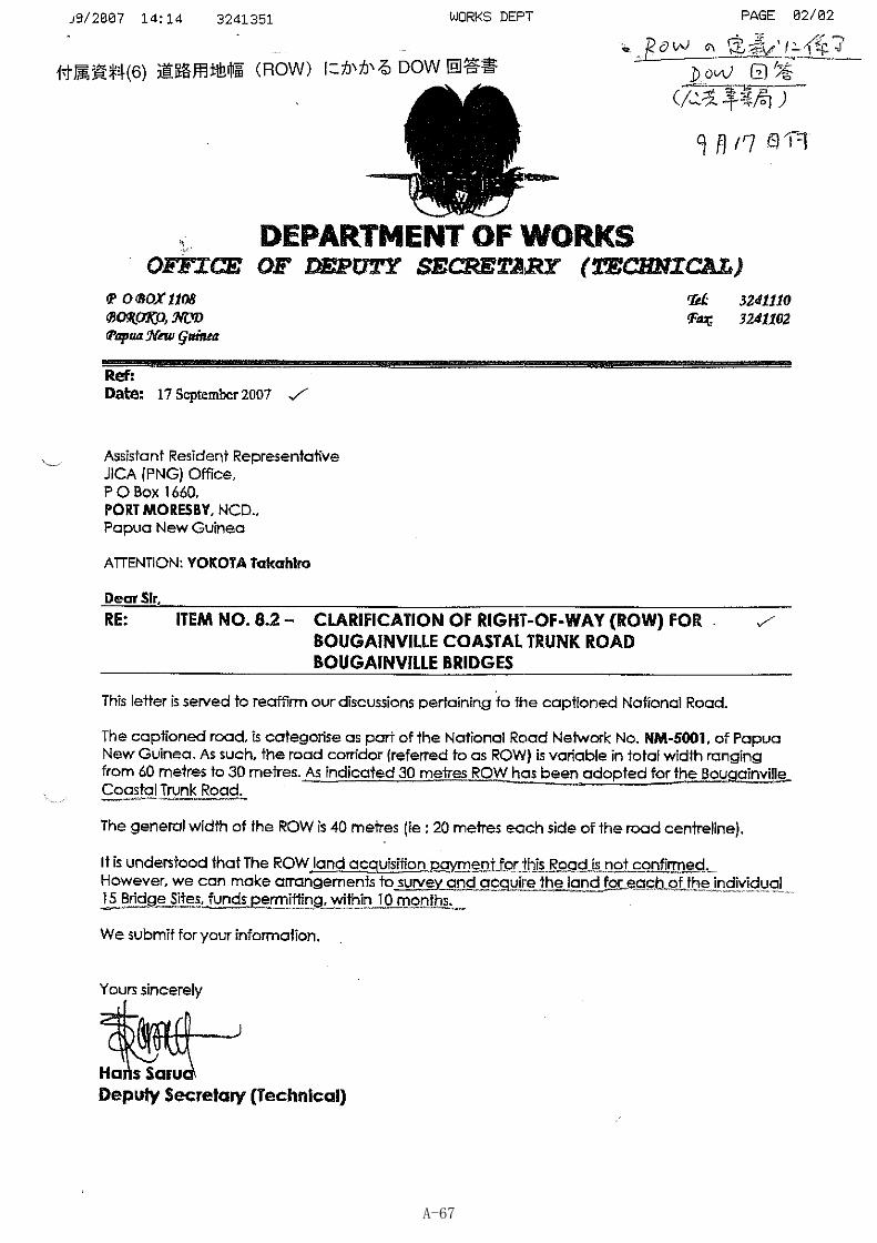
A-67
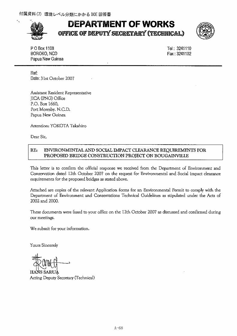
A-68
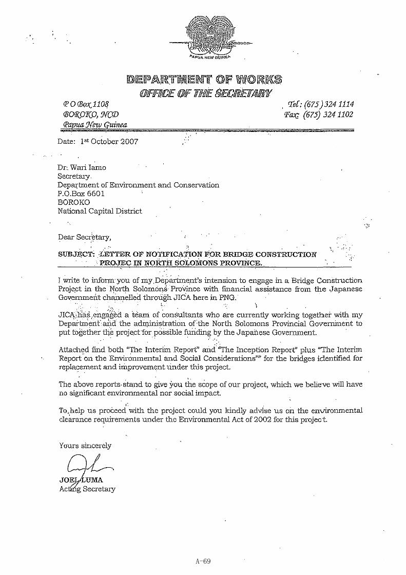
A-69
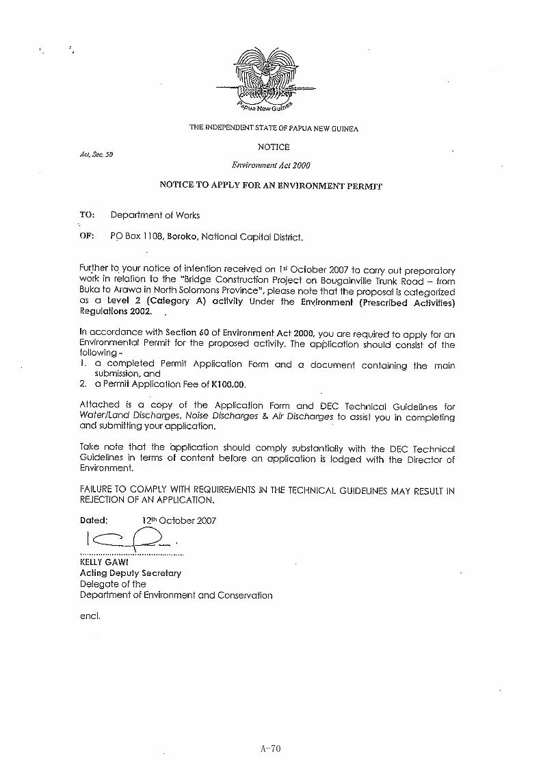
A-70
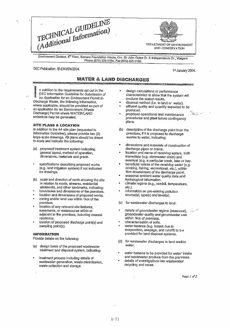
A-71
A-72
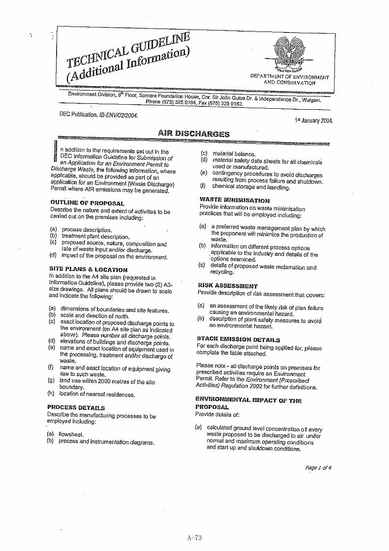
A-73
A-74
A-75
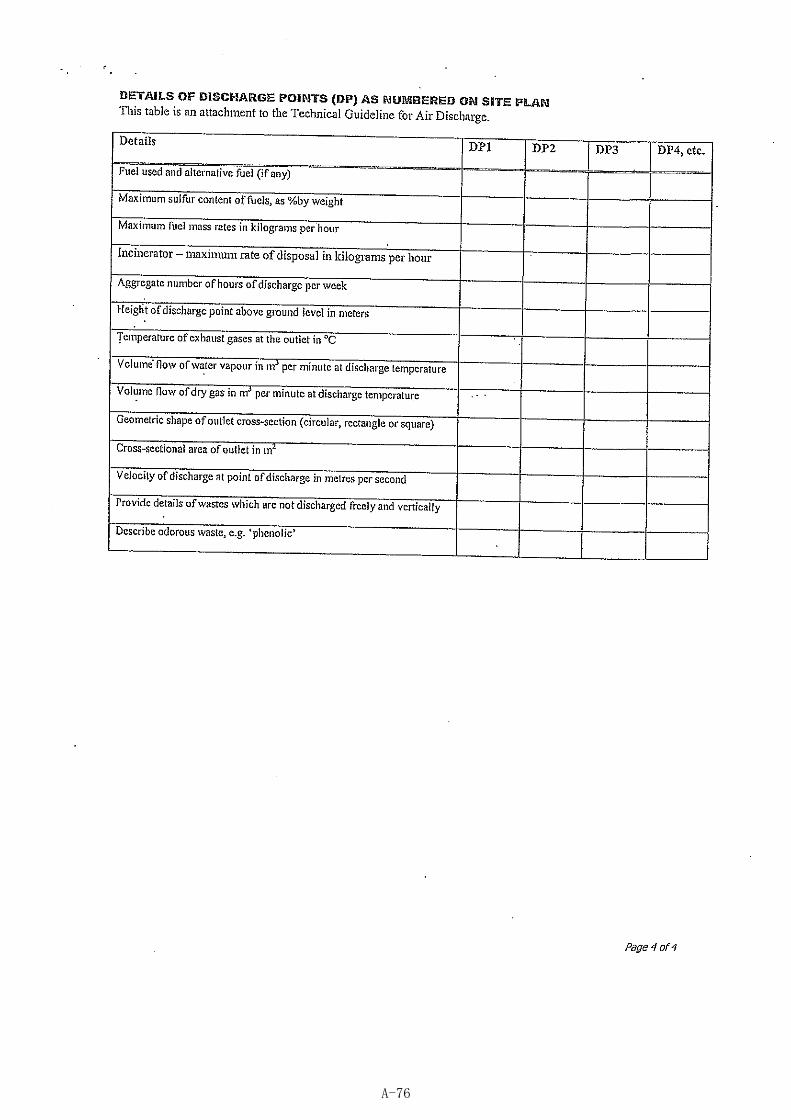
A-76
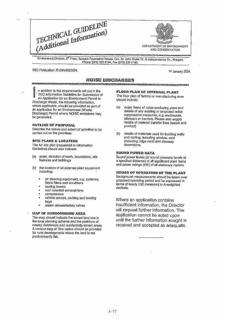
A-77
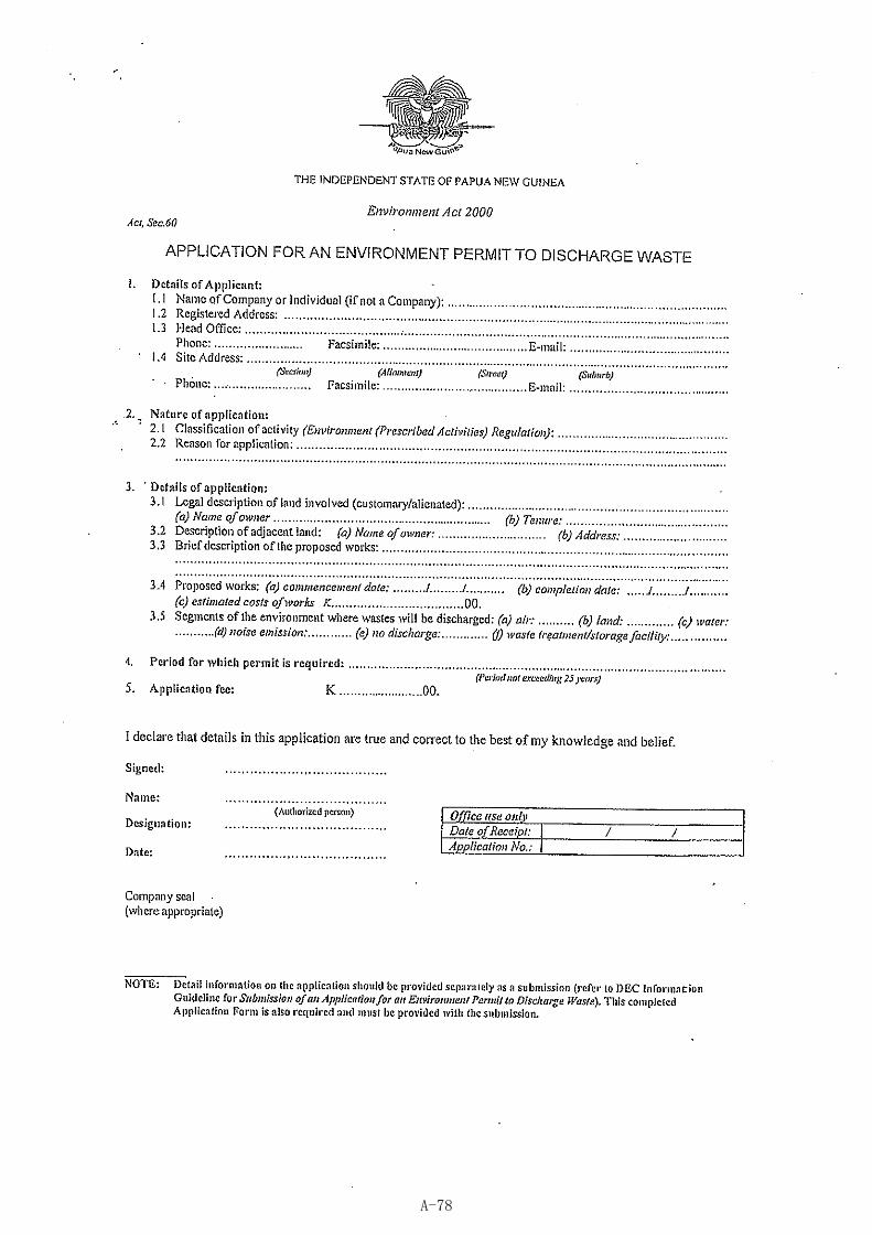
A-78
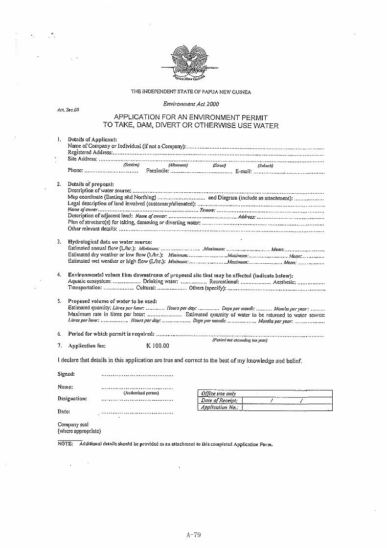
A-79
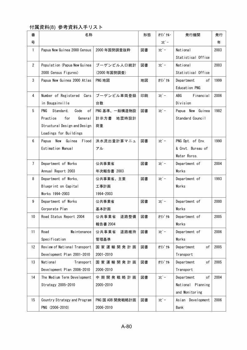
A-80
付属資料(8) 参考資料入手リスト 番
号
名称 形態 オリジナル・
コピー
発行機関 発行
年
1 Papua New Guinea 2000 Census 2000 年国勢調査抜粋 図書 コピー National
Statistical Office
2003
2 Population (Papua New Guinea
2000 Census Figures)
ブーゲンビル人口統計
(2000 年国勢調査)
図書 コピー National
Statistical Office
2003
3 Papua New Guinea 2000 Atlas PNG 地図 地図 オリジナル Department of
Education PNG
1999
4 Number of Registered Cars
in Bougainville
ブーゲンビル車両登録
台数
印刷 コピー ABG Financial
Division
2006
5 PNG Standard, Code of
Practice for General
Structural Design and Design
Loadings for Buildings
PNG 基準、一般構造物設
計示方書 地震時設計
荷重
図書 コピー Papua New Guinea
Standard Council
1982
6 Papua New Guinea Flood
Estimation Manual
洪水流出量計算マニュ
アル
図書 コピー PNG Dpt. of Env.
& Cnvt. Bureau of
Water Rsrcs.
1990
7 Department of Works
Annual Report 2003
公共事業省
年次報告書 2003
図書 コピー Department of
Works
2004
8 Department of Works,
Blueprint on Capital
Works 1994-2003
公共事業省、主要
工事計画
1994-2003
図書 コピー Department of
Works
1993
9 Department of Works
Corporate Plan
公共事業省
基本計画
図書 コピー Department of
Works
2000
10 Road Status Report 2004 公共事業省 道路整備
報告書 2004
図書 オリジナル Department of
Works
2005
11 Road Maintenance
Specification
公共事業省 道路維持
管理基準
図書 コピー Department of
Works
2006
12 Review of National Transport
Development Plan 2001-2010
国 家 運 輸 開 発 計 画
2001-2010
図書 オリジナル Department of
Transport
2005
13 National Transport
Development Plan 2006-2010
国 家 運 輸 開 発 計 画
2006-2010
図書 オリジナル Department of
Transport
2005
14 The Medium Term Development
Strategy 2005-2010
中 期 開 発 戦 略 計 画
2005-2010
図書 コピー Department of
National Planning
and Monitoring
2004
15 Country Strategy and Program
PNG (2006-2010)
PNG 国 ADB 開発戦略計画
2006-2010
図書 コピー Asian Development
Bank
2006
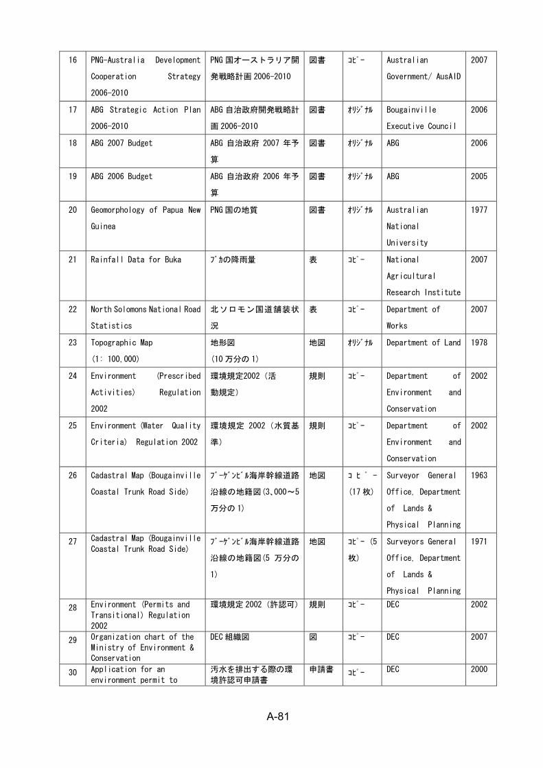
A-81
16 PNG-Australia Development
Cooperation Strategy
2006-2010
PNG 国オーストラリア開
発戦略計画 2006-2010
図書 コピー Australian
Government/ AusAID
2007
17 ABG Strategic Action Plan
2006-2010
ABG 自治政府開発戦略計
画 2006-2010
図書 オリジナル Bougainville
Executive Council
2006
18 ABG 2007 Budget ABG 自治政府 2007 年予
算
図書 オリジナル ABG 2006
19 ABG 2006 Budget ABG 自治政府 2006 年予
算
図書 オリジナル ABG 2005
20 Geomorphology of Papua New
Guinea
PNG 国の地質 図書 オリジナル Australian
National
University
1977
21 Rainfall Data for Buka ブカの降雨量 表 コピー National
Agricultural
Research Institute
2007
22 North Solomons National Road
Statistics
北ソロモン国道舗装状
況
表 コピー Department of
Works
2007
23 Topographic Map
(1: 100,000)
地形図
(10 万分の 1)
地図 オリジナル Department of Land 1978
24 Environment (Prescribed
Activities) Regulation
2002
環境規定2002(活
動規定)
規則 コピー Department of
Environment and
Conservation
2002
25 Environment (Water Quality
Criteria) Regulation 2002
環境規定 2002(水質基
準)
規則 コピー Department of
Environment and
Conservation
2002
26 Cadastral Map (Bougainville
Coastal Trunk Road Side)
ブーゲンビル海岸幹線道路
沿線の地籍図(3、000~5
万分の 1)
地図 コ ヒ ゚ ー
(17 枚)
Surveyor General
Office, Department
of Lands &
Physical Planning
1963
27 Cadastral Map (Bougainville
Coastal Trunk Road Side) ブーゲンビル海岸幹線道路
沿線の地籍図(5 万分の
1)
地図 コピー (5
枚)
Surveyors General
Office, Department
of Lands &
Physical Planning
1971
28 Environment (Permits and
Transitional) Regulation
2002
環境規定 2002(許認可) 規則 コピー DEC 2002
29 Organization chart of the
Ministry of Environment &
Conservation
DEC 組織図 図 コピー DEC 2007
30 Application for an
environment permit to
汚水を排出する際の環
境許認可申請書
申請書 コピー DEC 2000
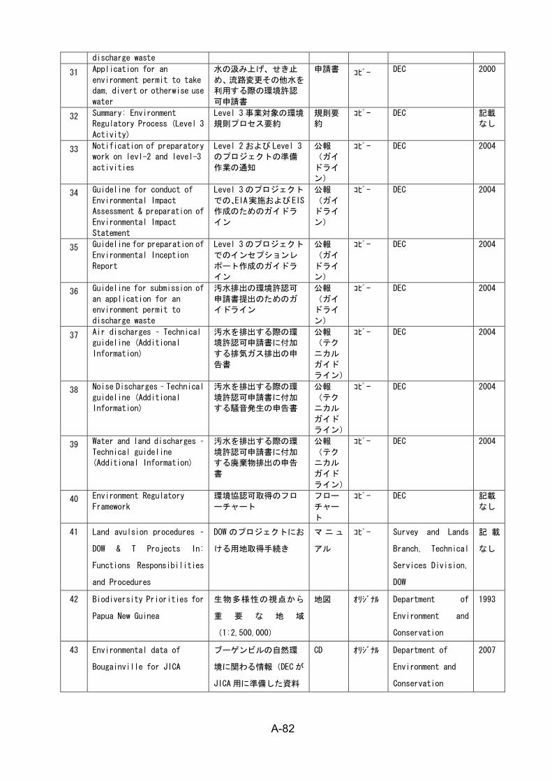
A-82
discharge waste
31 Application for an
environment permit to take
dam, divert or otherwise use
water
水の汲み上げ、せき止
め、流路変更その他水を
利用する際の環境許認
可申請書
申請書 コピー DEC 2000
32 Summary: Environment
Regulatory Process (Level 3
Activity)
Level 3 事業対象の環境
規則プロセス要約
規則要
約
コピー DEC 記載
なし
33 Notification of preparatory
work on levl-2 and level-3
activities
Level 2 および Level 3
のプロジェクトの準備
作業の通知
公報
(ガイ
ドライ
ン)
コピー DEC 2004
34 Guideline for conduct of
Environmental Impact
Assessment & preparation of
Environmental Impact
Statement
Level 3 のプロジェクト
での、EIA実施およびEIS
作成のためのガイドラ
イン
公報
(ガイ
ドライ
ン)
コピー DEC 2004
35 Guideline for preparation of
Environmental Inception
Report
Level 3 のプロジェクト
でのインセプションレ
ポート作成のガイドラ
イン
公報
(ガイ
ドライ
ン)
コピー DEC 2004
36 Guideline for submission of
an application for an
environment permit to
discharge waste
汚水排出の環境許認可
申請書提出のためのガ
イドライン
公報
(ガイ
ドライ
ン)
コピー DEC 2004
37 Air discharges – Technical
guideline (Additional
Information)
汚水を排出する際の環
境許認可申請書に付加
する排気ガス排出の申
告書
公報
(テク
ニカル
ガイド
ライン)
コピー DEC 2004
38 Noise Discharges – Technical
guideline (Additional
Information)
汚水を排出する際の環
境許認可申請書に付加
する騒音発生の申告書
公報
(テク
ニカル
ガイド
ライン)
コピー DEC 2004
39 Water and land discharges –
Technical guideline
(Additional Information)
汚水を排出する際の環
境許認可申請書に付加
する廃棄物排出の申告
書
公報
(テク
ニカル
ガイド
ライン)
コピー DEC 2004
40 Environment Regulatory
Framework
環境協認可取得のフロ
ーチャート
フロー
チャー
ト
コピー DEC 記載
なし
41 Land avulsion procedures –
DOW & T Projects In:
Functions Responsibilities
and Procedures
DOW のプロジェクトにお
ける用地取得手続き
マ ニュ
アル
コピー Survey and Lands
Branch, Technical
Services Division,
DOW
記 載
なし
42 Biodiversity Priorities for
Papua New Guinea
生物多様性の視点から
重 要 な 地 域
(1:2,500,000)
地図 オリジナル Department of
Environment and
Conservation
1993
43 Environmental data of
Bougainville for JICA
ブーゲンビルの自然環
境に関わる情報(DEC が
JICA 用に準備した資料
CD オリジナル Department of
Environment and
Conservation
2007
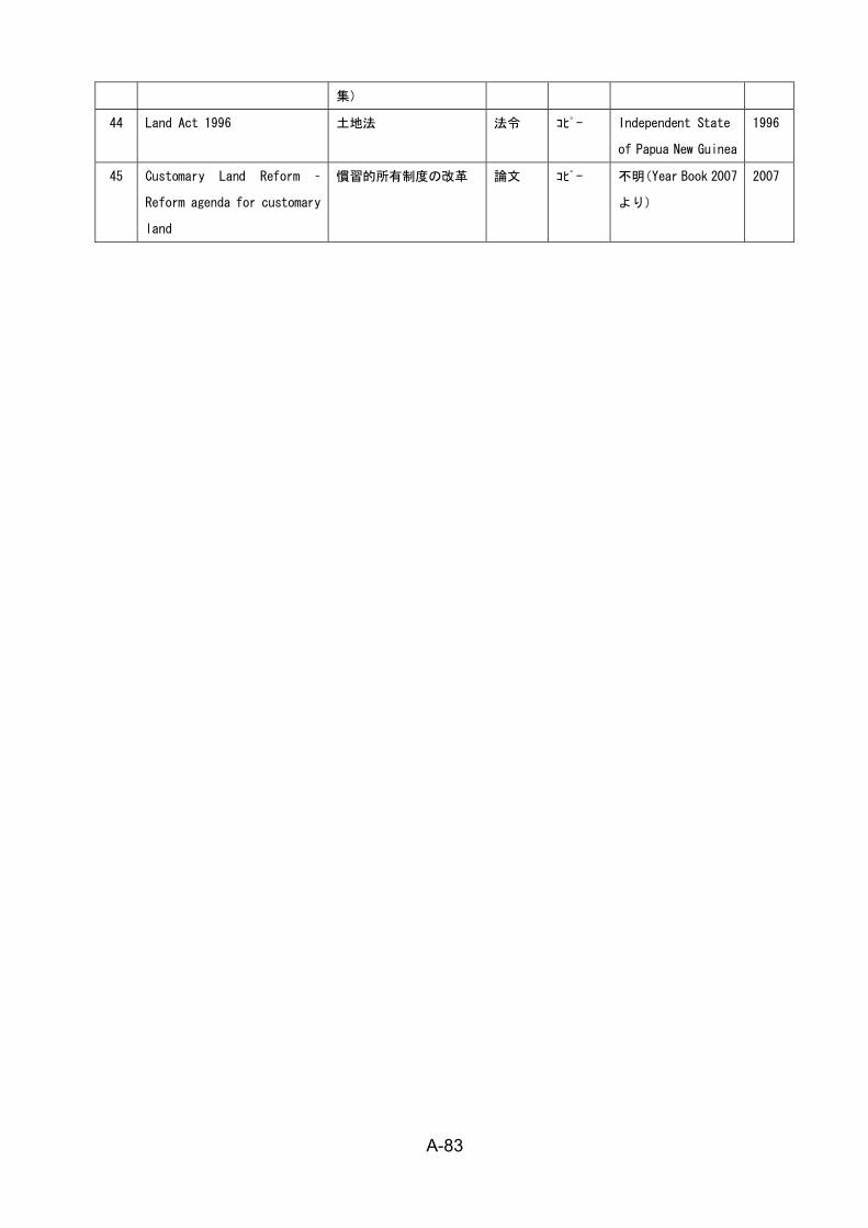
A-83
集)
44 Land Act 1996 土地法 法令 コピー Independent State
of Papua New Guinea
1996
45 Customary Land Reform –
Reform agenda for customary
land
慣習的所有制度の改革 論文 コピー 不明(Year Book 2007
より)
2007