Embed Size (px)
Citation preview
Fačkovcová Z., Senko D., Svitok M. & Guttová A. (2017): Ecological niche conservatism shapes the distributions of lichens: geographical segregation does not reflect ecological differentiation. – Preslia 89: 63–85. Electronic Appendix 1. – List of examined herbarium specimens and published references related to the occurrence and distribution of Solenopsora candicans (Dicks.) J. Steiner and S. cesatii (A. Massal.) Zahlbr. Symbol * indicates the entries which were used for identification of niche overlap of the study species (see Material and method – Species records). SOLENOPSORA CANDICANS (Dicks.) J. Steiner Revised herbarium specimens. Not specified (as Ricasolia candicans, Herb. Mus. Palat. Vindob. in W 19502).—Algeria: R. R. sur les roches calcaires d'Azeba et Constantine, leg. Flagey (as Ricasolia candicans, LISU).—Belgium: Bouvignes, ad saxa calcarea, 15.5.1904 (as Ricasolia candicans, Herb. C. Sbarbaro in FH 00377481, 00377482). Marche-les-Dames: 25.8.1967, E. Jacques (BR-LICH 12859–55). Mosan: Merlemont, ligne de chemin de fer désaffectée longeant la carrière du tiennede Merlemont, 230 m, 23.1.2005, leg. D. Ertz (BR-LICH 15040–05); ibid., 235 m, 25.5.2012, 50°10.474'N 4°36.787'E, leg. A. Guttová & A. Krolopp (SAV).—Bosna and Hercegovina: H. Lojka Lichenotheca Universalis, No. 227, super saxa dolomitica aprica circum Konjica in Hercegovina, 13.7.1886, leg. H. Lojka (as Lecanora candicans, BP 85601, Herb. lich. J. Suza in PRM 639449, Herb. Mus. Palat. Vindob. 1888 in W 223)*.—Bulgaria: Nos Kaliakra: Nature Reserve Bolata, NE of the Cape Kaliakra, limestone outcrops, 10 m, 4.9.2013, 43°23.027'N 28°28.311'E, leg. A. Guttová & M. Slovák (SAV). Pontus: Distr. Burgas, inter pagos Varvara et Mičurín, ad scopulus maritimum, 1–10 m, 22.8.1977, leg. A. Vězda (PRA-V-01980); ibid., 3–5 m, 18.8.1975, leg. A. Kiszely & A. Vězda (GZU 62-88, PRA-V-01982).—Croatia: Schuler Kryptogamae exsiccatae, No. 1364, Istria, ad saxa dolomitica murorum ad viam publicam inter Hosti et Sv. Matije, 200–250 m, leg. J. Schuler (as Placolecania candicans, FH 00377485, FI, O-L58238, PRC 2914, Herb. V. Kuťák in PRM 767335, Herb. Mus. Palat. Vindob. 1907 in W 16993); Vězda Lichenes Selecti Exsiccati, No. 742, Split, prope pagum Rogoznica, ad muros et lapidibus calcareis compositos, 10 m, 3.6.1968, leg. A. Vězda (BM, BP 72941, LISU, PRA-V-06342)*; Flora v. Dalmaten, No. 51, Babino Polje, Lago Blatina, ca 80 m, 16.2.1968, leg. A. Latzel, (as Placolecania candicans, Herb. Mus. Palat. Vindob. 1909 in W 5735). Biokovo Mts.: S foot of Sv. Jure Mts., 888 m, 12.6.2011, 43°15.585'N 17°6.073'E, leg. A. Guttová, K. Piknová, M. Slovák & J. Kučera (SAV)*; ibid., the plateau between Gornij Tučepi and Bukovac, 985 m, 12.6.2011, 43°16.376'N 17°5.934'E, leg. A. Guttová, K. Piknová, M. Slovák & J. Kučera (SAV)*. Dalmatia: leg. Baumgartner (as Placolecania candicans, Herb. lich. J. Suza in PRM 639447); Gebiet von Zara: Nord-Lunga, Wegmauern bei Dragove, kalk., ca 150 m, 17.4.1913, leg. J. Baumgartner (as Placolecania candicans, Herb. Mus. Palat. Vindob. 1916 in W 4519); ibid., Sud-Lunga, Wegmauern zwischen Žman u. Luka, kalk., ca 20 m, 8.4.1913, leg. J. Baumgartner (as Placolecania candicans, Herb. Mus. Palat. Vindob. 1916 in W 4399); ibid., Pašman, Wegmauern über Dobropoljana a.d. N.O. – Küste, kalk., ca 150 m, 23.3.1913, leg. J. Baumgartner (as Placolecania candicans, O-L58241, Herb. Mus. Palat. Vindob. 1913 in W 14332); Korcula, Steine einer Mauer eines Ölgartens südlich Korcula auf der insel Korcula (gegen Lumbarda), leg. J. Poelt (Vergleichsherbar J. Poelt 7365 in GZU 62-88); ibid. leicht beschattete Kalkblöcke am St. Antonius-Hügel südlich Korcula auf der Insel Korcula, August 1969, leg. J. Poelt (Vergleichsherbar J. Poelt 7371 in GZU 62-88); Lagosta, kalk., ca 100 m, 26.3.1910, leg. J. Baumgartner (as Placolecania cesatii, Herb. Mus. Palat. Vindob. 1912 in W 1759); Lesina: Slavica, bai Città vecchia, kalk., ca 50 m, 20.3.1904, leg. J. Baumgartner, det. A. Zahlbruckner (as Lecania (Ricasolia) candicans, Herb. Mus. Palat. Vindob. 1904 in W 5193); Peninsula Pelješac, in vicinitate vici Žuljana, ad scopulos maritimos calcareos, 1–5 m, 20.7.1979, leg. et det. A. Vězda (BM; GZU 110N-79; PRA-V-01976); Rab (Arbe), Hügel bei der gleichnamigen stadt, flysch, ca 50 m, 8.4.1926, leg. J. Baumgartner, det. A. Zahlbruckner (as Placolecania candicans, Herb. Mus. Hist. Natur. Vindob. 1927 in W 12023); Ragusa [Dubrovnik], 60 m, 11.9.1908, leg. A. Latzel (as Placolecania cesatii, FI); ibid., Villa Gondola, kalk., 10 m, 1908, leg. Latzel, det. Zahlbruckner (as Placolecania cesatii, FH 00377489); ibid., Lapad, saxa calc., 60 m, 11.2.1908, leg. A. Latzel (as Placolecania cesati, Herb. lich. J. Suza in PRM 639451); ibid., Žarkovica, 180 m, calc., 1907, leg. A. Latzel, det. A. Zahlbruckner (as Solenopsora cesati, Herb. lich. M. Servít in PRM); ibid., 1908, leg. A. Latzel, Flora dalmatica 7714 (as Placolecania cesati, Herb. lich. M. Servít in PRM). Humina Mts.: Zaton Doli, 134 m, 12.6.2011, 42°48.984'N 17°46.616'E, leg. A. Guttová, K. Piknová, M. Slovák & J. Kučera (SAV)*. Istria: Sud-Cherso, bai Punta Croce, Kalk., 150 m, 24.4.1909, leg. J. Baumgartner (as Placolecania candicans, Herb. Mus. Palat. Vindob. 1912 in W 10436); Rovigno, mauern an der strasse gegen Valle, kalk., ca 25 m, 5.4.1924, leg. J. Baumgartner, det. A. Zahlbruckner (as Placolecania candicans, O-L58243, Herb. Mus. Hist. Natur. Vindob. 1926 in W 329); Albona [Labin], 5.1925, 150 m, leg. J. Baumgartner (as Placolecania candicans, O-L58256).—Cyprus: 3 km NE of Kathikos along road between Kathikos and Pano Akourdalia, 500 m, 26.4.1990, 34°55'N 32°27'E, leg. E. Timdal No. 7337 (O-L).—France: W. Nylander Herb. Lich. Paris., No. 117, ad saxa calcarea prope Moret (as Placodium candicans, BM, Herb. Mus. Palat. Vindob. 1911 in W 4421); Claud et Harm. Lich. gall. exs., No. 540, Le Val à Chaumiton (Sarthe), ad saxa calcarea, leg. Monguillon (as Lecanora candicans, FH 00377484, Herb. Mus. Palat. Vindob. 1914 in W 3353). Agen: apud Saint-Amans, Flore ageniase (as Lichen candicans, G 00295696). Ardèche: Les Vans – Berrias, Bois de Païolive, 224 m, 15.7.2012, 44°23.809'N 4°10.72'E, leg. A. Guttová & L. Paoli (SAV)*. Basse Provence: Èze, 655 m, 11.7.2012, 43°44.395'N 7°21.475'E, leg. A. Guttová & L. Paoli (SAV)*; ibid., Rochers Col. d'Èze, 27.3.1923, leg. L. Giltay (BR-
LICH); Nizza [Nice], leg. A. Metzler (as Ricasolia candicans, O-L58244); ibid., Mt. Boron, 150 m, 11.7.2012, 43°41.405'N 7°18.194'E, leg. A. Guttová & L. Paoli (SAV)*; ibid., Mt. Alban, ad saxa calcarea, ca 200 m, April 1927, leg. J. Suza, det. A. Vězda (PRA-V-01977, as Placolecania candicans, Herb. lich. J. Suza in PRM 639448); ibid., Villefranche p. M. ad muros, ca 100 m, April 1927, leg. J. Suza (as Placolecania candicans, Herb. lich. J. Suza in PRM 639445). Bouches-du-Rhône: prope Chateauneuf-les-Mariques, ad rupes calcarias, 50 m, 22.4.1965 leg. A. Vězda (PRA-V-01979). Bretagne: Cancale, Le Verger, Le Petit Port, at the top of low metamorphic coastal rock outcrop facing the sea with occasional freshwater seeping over the rock, half shaded between low shrubs, 14 m, Sept-Oct 2015, 48°41'46.5''N 1°53'06.6''W, leg. H. Thüs & J. Esnault (SAV). Calvados: 1897 (as Placodium epigeum, G 00295700). Provence: Cavaillon, St. Jacques Mt., 150 m, 12.7.2012, 43°50.116'N 5°1.895'E, leg. A. Guttová & L. Paoli (SAV)*; ibid., St. Rémy de Provence – Glanum, 129 m, 13.7.2012, 43°46.359'N 4°49.835'E, leg. A. Guttová & L. Paoli (SAV)*. Vaucluse: entre Peyrole et les Imbardes (400 m s. m.), Apt (Vaucluse), sur molasses burdigalienne, exp. N, sous Quercus pubescens, 2.10.1954, leg. G. Clauzade (LISU); ibid., Rochers de Peyrole (400 m) (Vaucluse), sous Quercus pubescens, paroi de molasse burdigalienne, exp. à l'W, 2.10.1954, leg. et det. G. Clauzade (LISU).—Germany: Rabenhorst, Lichenes europaei No. 748, auf Kalkblocken bei Trier, leg. A. Metzler (as Ricasolia candicans, Herb. lich. J. Suza in PRM 639446); Rabenhorst, Lichenes europaei No. 848 (as Ricasolia candicans, LISU). Niedersachsen: südl. Harzvorland, an bodennahen Zechstein-Dolomit-Blöcken, Stirn- u., Neigungsflächen, exp. SO-S, beim Königstein auf dem Pagenberg bei Eisdorf, 260 m, 7.6.1962, leg. et det. H. Ullrich (LISU). Oberfranken: Kleinziegenfeld, calcareous rocky outcrops along main road, SW-exposed slope, on plane rock faces mainly with NE exposition, 443 m, 15.4.2015, 50°01.297'N 11°12.316'E, leg. Z. Fačkovcová & V. Kučera, det. Z. Fačkovcová (SAV); ibid., an Dolomitfelsen eines grasigen Abhangs bei Kleinziegenfeld im Weissmainbachthale, May 1862, Arnold (as Ricasolia candicans, TO); An dolomitfelsen der Kemitzen-Steine westlich von Weissmain im Frankenjura. 4.9.1887, leg. Arnold (as Ricasolia candicans, O-L58261, O-L58236, Herb. lich. J. Suza in PRM 639450); Jura, Kemitzensteine bei Schwabtal, 1895, leg. Glück (O-L58289); Wallersberg, calcareous rocky outcrops close to road, S-exposed slope, on plane rock faces, 445 m, 15.4.2015, 50.044101°N 11.214801°E, leg. Z. Fačkovcová & V. Kučera, det. Z. Fačkovcová (SAV). Thüringen: Allendorf, calcareous rocky outcrops in forest (Pinus sp., Fagus sp., Prunus spinosa, Crataegus sp.), W-slope, on shaded rocks, 405 m, 16.4.2015, 50°39.188'N 11°09.716'E, leg. Z. Fačkovcová & V. Kučera, det. Z. Fačkovcová (SAV); Creuzburg, NR Nordmannssteine, limestone outcrops close to quarry, basal-middle part of massive, W-slope, on semi-shaded plane rock faces, 240 m, 17.4.2015, 51°03.780'N 10°16.558'E, leg. Z. Fačkovcová & V. Kučera, det. Z. Fačkovcová (SAV); Jena, Kernberg, shaded limestone rocks on forest border, close to touristic path, on rock, 280 m, 17.4.2015, 50.909112°N 11.603172°E, leg. Z. Fačkovcová & V. Kučera, det. Z. Fačkovcová (SAV); An einem Muschelkalkfelsen bei Jena, 1859, Dr. Ahles (as Ricasolia candicans, W 223).—Great Britain: not specified (as Squamaria candicans, Miss Moseley′s Herbarium 1886 in BM); W. Johnson Lich. Herb. exs., No. 411, on walls near Hunt's Cross, Ingleton, Yorkshire, and Masson Hill, Matlock (as Lecanora candicans, BM, BP 20416, Herb. Mus. Palat. Vindob. 1913 in W 435); Anglesey, Llyn Cadern, V.C. 52, on limestone. M. R. 106/500813, April 1962, leg. et det. P. W. James (BM); Bathampton (as Placodium candicans, Heb. W. Joshua in BM); Beachy Head (Ed. Forster′s Herbarium 1849 in BM); Breckon, Llangattock Quarries, Crickhowell, V.C. 42, 32/18-16-, on limestone boulders, 22.5.1983, leg. P. W. James (BM); Carnarvonshire, Great Ormes Head, on rocks, 1878 (Ex. Herb. Hort. Bot. Reg. Kew in G 00295699); ibid., Leighton, Lich. Brit. No. 218 (as Lecidea rimosa, O-L58259); Claverton Down near Bath, 1809 (as Lichen candicans, Ed. Forster's Herbarium 1849 in BM); Dorset, Purbeck Hills, Langton Matravers village, Parish church of Saint George, S-facing walls, at a height of app. 1.5–2 m above the ground, half-shaded site, 82 m, Sept 2015, 50°36'34.62''N 2°0'13.60''W, leg. H. Thüs (SAV); ibid., graveyard of Langton Matravers, SE-facing graveyard walls, at a height of app. 1.5 m above the ground, fully sun-exposed, 77 m, Sept 2015, 50°36'34.62''N 2°0'9.16''W, leg. H. Thüs (SAV); Llamynynech, NW, August 1813 (as Placodium candicans, Ex Herb. W. Phillips in BM, Herb. T. Salwey 1877 in BM); Oswestry (as Squamarina candicans, Herb. T. Salwey 1877 in BM); Portland, boll. E. M. Holmes (as Placodium candicans, Herb. E. M. Holmes in BM); Somerset, Brendon Hills, Williton, Monksilver village, graveyard around Monksilver parish church, on gravestones, 94 m, 3.9.2015, 51.128669°N 3.3261594°W, leg. P. Wolseley (SAV); Weston-super-Mare, 1830 (as L. candicans, Ex Herb. M. J. Berkeley 1894 in BM).—Greece: Attika: Blöcke und niedrige Felsen in Macchie oder lockerem Wald unweit Kloster Kaissariani (Kesariani) am Hymettos (Imittos) bei Athen, 5./6.4.1971, leg. J. Poelt (Vergleichsherbar J. Poelt 10250 in GZU 62-88). Insula Andros: ad rupem prope aediculam Prof. Ilias in monte Dhomata, ca 527 m, 17.9.2001, leg. V. Orthová (SAV)*. Insel Kerkyra (Korfu): Dolinenartiges Gelände zwischen Strinilas und dem Pantokrator, 700–800 m, August 1970, leg. J. Poelt (Vergleichsherbar J. Poelt 9351 in GZU 62-88); ibid., Locker von Büschen bestandene nord – seitige Hänge des Pantokrator, 850–900 m, August 1970, leg. J. Poelt (Vergleichsherbar J. Poelt 8955 in GZU 3-92); ibid., Pantokratoras, 0.3 km W of Perama, limestone boulder in olive grove, 740 m, 14.7.2014, 39°45.08'N 19°50.92'E, leg. S. Rui & E. Timdal (O-L196236); W of Spartilas, semi-exposed limestone outcrop in olive grove, 400 m, 16.7.2014, 39°43.24'N 19°50.25'E, leg. S. Rui & E. Timdal (O-L196256). Insel Kreta: Nomós Iraklíou: SW Ortsrand von Pitsidia, Felsblöcke am Straßenrand, Kalksandstein, ca 100 m, 16.5.1997, 35°00'30''N 24°46'30''E, leg. et det. Ulrike Trinkaus (GZU 32-2014); Chania, along road Vrisses – Amoudari, on rock, 450 m, 29.5.2009, 35°19.81'N 24°12.14'E, leg. S. Rui & E. Timdal (O-L156000); Iráklion, between Kastéllion and Khersónisos, bottom of gorge of river Apossolemis, on boulder by a dry brook, shady, 250 m, 30.5.2000, 35°14.2'N 25°21.6'E, leg. S. Rui & E. Timdal No. 8019 (O-L). Insel Samos: Umgebung von Pythagorion Schlucht NW Pythagorion, August 1984, leg. J. Poelt (GZU 99-84). Insula Thassos: ad saxa marmorea in declivi boreoor. supra pagum Panagia, ca 450 m, 25. 8. 2007, leg. I. Pišút (Herb. I. Pišút)*; Thassos, dirt road off main road from Potos to Theologos, near Stavri, E-facing limestone wall in cayon in open pine forest, 300
m, 6.6.2000, 40°37.6'N 24°42.8'E, leg. S. Rui & E. Timdal (O-L59297); ibid., along small dirt road off main road from Thassos town to Panagia, limestone rocks by road in pine forest, 320 m, 30.5.2000, 40°44.6'N 24°43.9'E, leg. S. Rui & E. Timdal (O-L59234). Konitsa: Ioanina, near the bridge above the river Aoos, on limestone rock, 450 m, 14. 6. 2015, 40°02'11.7''N 20°44'42.6''E, leg. M. Slovák & E. Štubňová (SAV). Peninsula Athos: ad monastir Aia Anna, ca 2–400 m, supra saxa calcarea, 24.8.1934 (BP 20425)*. Peloponnese: Achaia – Giannaskari Bay, site 52-32-A, limestone rock, 0 m, 26.2.2007/L31H, UTM 532161E 4225071N, 38°10'23''N 21°22'02''E (Herb. Linda in Arcadia); ibid., Messinia – on track between Plati and Moli, site 51-61-A, limestone rock, 850 m, 24.2.2005, UTM 561017E 411404IN, 37°10'15''N 21°41'14''E (Herb. Linda in Arcadia).—Hungary: Bakony Mts.: Hajmáskér, 207 m, 13.5.2010, 47°8.081'N 18°0.085'E, leg. A. Guttová, L. Lőkös, E. Farkas & K. Molnár (SAV)*. Balaton-felvidék: Tihanyi-félsziget, Tihany, Kiserdő-hegy, "Szélmarta sziklák", along the green triangle and green "T" tourist route, on basalt, 185 m, 23.10.2013, 46°54'59.1''N 17°52'39.6''E, leg. A. Guttová, A. Lackovičová, E. Farkas & N. Varga (SAV)*. Buda Mts.: Hungaria centr. inter pagos Pilisszentiván et Nagykovácsi, in montibus Nagyszénás, calcareicola, 15.4.1934, leg. V. Gyelnik, det. Ö. Szatala (BP 20417)*. Keszthély Mts.: Gyenesdiás, Kőmell Mt., 227 m, 11.5.2010, 46°47.055'N 17°17.27'E, leg. A. Guttová, L. Lőkös, E. Farkas & K. Molnár (SAV)*; ibid., Rezi, Rezi vár castle ruins, 310 m, 11.5.2010, 46°51.978'N 17°13.354'E, leg. A. Guttová, L. Lőkös, E. Farkas & K. Molnár (SAV); ibid., in collibus Rezi csere dolomit, July 1947 (BP 20418)*.—Israel: Golan: Ein Kinya, limestone outcrops, 680 m, 8.3.2014, 33°13'43.68''N 35°43'51.75''E, leg. A. Guttová, M. Slovák & J. Kučera (SAV). Heifa: Carmel Mt., above the quarry along the road no 705, on limestone rocks, 409 m, 7.3.2014, 32°45.264'N 35°1.739'E, leg. A. Guttová, M. Slovák & J. Kučera (SAV).—Italy: not specified (as Ricasolia candicans, Herb. Körber in O-L58252); A. Massalongo Lichenes Exsiccati Italiae, No. 210 (as Ricasolia candicans, O-L58250, TO, W)*; Cryptogamae exsiccatae editae a Museo Hist. Natur. Vindobonensi, No. 4234, Italien, Ligurien, SE-Hang des Monte Bellenda gegen San Bartolomeo bei Ventimiglia, auf kalkhältigem Sandstein einer Bruchsteinmauer der Ölgärten, ca 250 m, 26.4.1958, leg. et det. M. Steiner (LISU, O-L58279, PRA-V-01983, Herb. Mus. Natur. Vindob. 1962 in W 09021)*; Lichenes rariores Langobardi Exsiccati Presb. Martinus Anzi, Nr. 447, Zugang mit Herbar Dr. F. Arnold Nov. 1901, ad saxa jurassica umbrosa domorum in monte Piatto supra Larium lacum [Lago di Como], 500 m (as Gyalolechia candicans var. cesatii f. dealbata, BM, O-L58248, PRA-V-01984, W) ; Erbar. Crittogam. Ital., No. 68 (1068), sulle rupi calcaree in diverse località dei dintorni di Genova, Baglietto (as Ricasolia candicans, FI, TO)*; Lichenes Alpium, No. 139, Alpi liguri, Liguria, presso di Colla Micheri al di sopra da Laigueglia, ca 160 m, su roccie esposte, May 1958, leg. M. Steiner (BM, Herb. Mus. Hist. Natur. Vindob. 1962 in W 6356, LISU)*; Anzi L. rar. Etr., No. 12, Ad rupes calcareas montis S. Juliani [San Giuliano], supra hujus nominis pagum, 250 m (as Gyalolechia candicans, O-L58264, Herb. Mus. Palat. Vindob. in W 19373). Abruzzo: between the villages Bussi and Popoli, rocky slopes (W–NW, calcareous rocks) in forest (Quercus spp, Fraxinus spp) along the road E80, on rock, 269 m, 7.7.2015, 42°11'39''N 13°51'09''E, leg. M. Slovák & A. Pleceníková (SAV). Basilicata: La Rotonda, rocca – rocky hilltop in the centre of the town, open limestone rocks, on rock faces, ca 627 m, 1.2.2015, 39°57.402'N 16°2.426'E, leg. A. Guttová & L. Paoli (SAV)*; Pollino Mt., Castelluccio superior, sentiero Bosco difesa, open limestone rocks in macchia type of vegetation, on rock faces, ca 736 m, 1.2.2015, 40°0.774'N 15°58.607'E, leg. A. Guttová & L. Paoli (SAV)*; ibid., humid Quercus cerris forest, shaded hard limestone outcrops and towers, on rock faces, ca 779 m, 1.2.2015, 40°0.726'N 15°59.042'E, leg. A. Guttová & L. Paoli (SAV)*; ibid., humid Quercus sp. div. forest, shaded hard limestone outcrops and horizontal forms, on rock, ca 910 m, 1.2.2015, 40°1.813'N 15°59.137'E, leg. A. Guttová & L. Paoli (SAV)*; Provincia di Potenza, Val d'Agri, Marsicovetere, NW slopes of the Sacro Monte di Viggiano, in fissures of limestone outcrops and towers, 1179 m, 7.12.2012, 40°22.61'N 15°50.025'E, leg. A. Guttová & L. Paoli (SAV)*; ibid., Grumento Nova, parco municipale, NE slope of the town, limestone outcrops in the forest park (Pinus sp., Cupressus sp.), on perpendicular rock face, 742 m, 8.10.2013, 40°16.984'N 15°53.2'E, leg. Z. Fačkovcová, A. Guttová & L. Paoli (SAV)*; ibid., E slope of the town hill, secondarily wooded area along the road (Cupressus sp., Pinus sp.) with shades limestone outrops (hard, carstic forms), on rock (extremely scarce), 653 m, 4.2.2015, 40°16'45.95''N 15°53'52.14''E, leg. A. Guttová & L. Paoli (SAV); ibid., banks of the Lago di Pertusillo, open xerotherm with karst formations, on limestone rock, 618 m, 7.4.2014, 40°16.667'N 15°55.171'E, leg. A. Guttová, A. Grassi, L. Paoli & S. Ravera (SAV)*; ibid., Viggiano, forested hilltop above the cemetery (Pinus sp., Cupressus sp.), N facing slope, on limestone rocks, 953 m, 10.10.2013, 40°20.434'N 15°53.7'E, leg. Z. Fačkovcová, A. Guttová & L. Paoli (SAV)*; ibid., along the road SS276 between Agriturismo Casteluccio and junction of SS276 and SP11bis, oak forest, on shaded limestone rock, perpendicular face, 708 m, 23.8.2013, 40°20.391'N 15°53.0'E, leg. A. Guttová & L. Paoli (SAV)*; ibid., Strada provinciale Grumento – Tramutola, southern xerotherm slope, limestone outcrops, on rocks, 644 m, 11.10.2013, 40°18.305'N 15°50.455'E, leg. Z. Fačkovcová, A. Guttová & L. Paoli (SAV)*; ibid., Strada comunale di Monserrato, la parte sotto la capella/chiesa di Monserrato, limestone outcrops in the pasture, on rocks, 724 m, 6.10.2013, 40°17.329'N 15°51.3'E, leg. Z. Fačkovcová, A. Guttová & L. Paoli (SAV)*; ibid., humid mixed forest on a slope facing capella/chiesa di Monserrato, on shaded limestone rock, alt. 805 m a.s.l., 7.4.2014, 40°17.134'N 15°51.627'E, leg. A. Guttová & L. Paoli (SAV)*; Viggianello, località “Torno”, shaded limestone outcrops among Quercus trees on pasture, on rock faces, ca 855 m, 1.2.2015, 39°58.854'N 16°6.709'E, leg. A. Guttová & L. Paoli (SAV)*. Calabria: Fiume Caronte (Dipignano CS), 500 m, 21.12.1985, leg. D. Puntillo (TSB 7024). Campania: Monti Lattari Mt., Tramonti, Valico di Chiunzi – mountain pass, limestone cliffs, sheltered, humid rock faces, ca 722 m, 6.2.2015, 40°43.143'N 14°37.161'E, leg. A. Guttová & L. Paoli (SAV)*; Prov. Salerno, Amalfi coast, between Ravello and Valico di Chiunzi on M. Cerreto, ca 3 km before the pass, narow gorge with Castanea, limestone, ca 600 m, 18.4.2000 leg. P. L. Nimis & M. Tretiach (TSB 31803). Friuli Venezia Giulia: Carso Triestino, M. Lanaro, su calcare, 500 m, 9.10.1985, leg. Nimis (TSB 6546); Malchina, su calcare, 170 m, 25.3.1985, leg. Nimis (TSB 5496); Val
Rosandra (TS), substrato – calcareous, 7.9.1987, leg. & Puntillo (CLU 4414, 4418)*. Lazio: Prov. Latina: Monti Arunci, M. S. Angelo, near Gaeta, road to the top, Fagus forest, dry calcareous grasslands, limestone rocks, ca 1200 m, 5.4.2000, leg. P. L. Nimis & M. Tretiach (TSB 32370). Liguria: Muretto a Pontecarrega (as Placolecania candicans, Herb. C. Sbarbaro in FH 00377487); Noli – Finale Ligure, olive growths, the walls of calcareous rocks along the road, on rock, 103 m, 11.7.2012, 44°11.504'N 8°21.608'E, leg. A. Guttová & L. Paoli (SAV)*; Riviera dei Fiori, San Bartolomeo al Mare, au-dessus de l'église, route au-dessus du camping La Rosa, affleurements rocheux, exp. plein Est, 50 m, 25.8.1982, 43°55'17''N 8°5'51''E, leg. et det. P. Clerc (FH 00377486, G 00295670, G 00272808). Lombardia: In calcarei supra Laveno ad Larium lacum, Garovaglio (as Lecanora candicans, TO, VER); ad lacum Larium, leg. et det. Garovaglio (as Parmelia candicans, BM; as Ricasolia candicans, TO). Marche: Prov. Pesaro, Montefeltro, S. Leo, calcareous outcrops just east of the village, Quercus, Robinia, 540 m, 19.8.1996, leg. P. L. Nimis (TSB 23522). Molise: Prov. Campobasso, below Lupara along river Biferno, dry calcareous rocks, cultivations, 280 m, 4.4.1997, 11°44'36''N 14°44'32''E, leg. Nimis & Tretiach (LISU 238452); Pozzilli, the plateau above the village mixed Quercus-Carpinus forest along the dirty road near the pasture, sheltered limestone boulders and rocks, on perpendicular faces, alt. 526 m, 11.4.2011, 41°31.415'N 14°04.734'E, leg. A. Guttová & S. Munzi (SAV)*; Roccaravindola (alta), borgo in via Boticelli/graveyard, mixed light Quercus-Carpinus forest above the quarry, on shaded calcareous rock and boulders along the path, 389 m, 9.4.2011, 41°32.013'N 14°06.979'E, leg. A. Guttová & S. Munzi (SAV)*; ibid., old rock terraces in the mixed Quercus-Carpinus forest, humid and sheltered place with Ceterach sp., on limestone rocks, 347 m, 8.4.2011, 41°31.901'N 14°07.131'E, leg. A. Guttová & S. Munzi (SAV)*; Santa Maria Oliveto, mixed light Quercus-Carpinus forests on the hills N of the village, a clearing with limestone rocks and boulders, on rock, 579 m, 7.4.2011, 41°31.919'N 14°05.604'E, leg. A. Guttová & S. Munzi (SAV)*. Puglia: Gargano, P.so del Lupo, Quercus, limestone, 530 m, 5.4.1996, leg. P. L. Nimis & M. Tretiach (TSB 22841); Isole Tremiti, Isola di S. Domino, su calcare, 50 m, 4.7.1986, leg. Nimis (TSB 7632); Martina Franca, Bosco delle Pianelle, querce decidue, muri di pietre calcaree in ombra, 400 m, 8.4.1996, leg. P. L. Nimis & M. Tretiach (TSB 22275); Prov. Foggia, Daunia, presso Ponte 13 Archi sul Lago di Catola below Calenza, calc. sandstone, cement, 245 m, 13.4.1998, leg. Nimis & Tretiach (TSB 30056). Sardinien: Prov. Nuoro, M. Albo, P. ta Cupetti, on limestone, 950 m, 25.7.1985, leg. Nimis et Poelt (TSB 6128); ibid., M. Arcueri, on limestone, 1000 m, 5.1986, leg. Nimis (TSB 7465); ibid., Barbágia Seúlo, ca 2.5 km S der Bahnstation Esterzili SW Seui. Kalk. Sh. 670–380 m. An Kalkfels, 3.5.1986, leg. et del. W. Brunnbauer (Herb. W. Brunnbauer 6072, Herb. Mus. Hist. Natur. Vind. 1999 in W 01159); ibid., Sotto P. Corongiu (Jerzu), su calcare, ca 900 m, 8.1989, leg. Nimis, Roux, Tretiach & Vězda (TSB 13 165). Sicilia: Marettimo (Égadi Islands TP), Buccerie, kalk, 260 m, excursion S.L.I., 24–31.3.1991, det. P. L. Nimis (TSB 15713, 18698); ibid. sopra Marettimo, calcareous rocks, 50 m, excursion S.L.I., 24–31. 3.1991, det P. L. Nimis (TSB 18705); ibid., Insula Marettimo, Égadi insulae, supra vicum Marettimo, 100 m, 24.–31.3.1991, leg. et det. A. Vězda (PRA-V-01978); ibid., Isole Égadi – TP, loc. Case Romane, substr. roccia calcarea, 260 m, 27.3.1991, leg. Puntillo (as S. cesatii, CLU 7707)*; Prov. Trapani: Riserva Nat. Dello Zingaro, kalk. macchia, 200–550 m, 11.12.1995, leg. P. L. Nimis & M. Tretiach (TSB 21523); ibid., San Vito lo Capo, NE slopes of the Monte Monaco, sheltered limestone outcrops, on rock faces, 70 m, 1.6.2016, 38°6'35''N 12°47'17'', leg. A. Guttová & H. Béreš (SAV). Toscana: A. S. Margherita in Monticci presso Firenze, 24.4.1805 (as Ricasolia cesatii, Erbario O. Beccari in FI)*; E. Marcucci Piante dell'Isola dell' Elba, Portoferraio, 8.5.1880 (as Ricasolia candicans, Erbario O. Beccari in FI); Giugliano, Toscana, August 1884 (as Lecanora candicans, Herb. U. Martelli in FI); Ancaiano, along the road between Passo degli Incrociati and Ancaiano, on hard limestone rocks along the road and in the humid oak forest, 505 m, 12.10.2013, 43°17.544′N 11°11.4′E, leg. Z. Fačkovcová, A. Guttová & L. Paoli (SAV)*; Castell'Azzara, Mt. Civitella – Mt. Penna, 1074 m, 10.4.2010, 42°46.406'N 11°40.081'E, leg. A. Guttová & L. Paoli (SAV)*; Cetona Mt., the massif above the town, open calcareous outcrops, ca 1000 m, 14.5.2010, 42.92583°N 11.880033°E, leg. L. Paoli (SAV)*; ibid., ca 1050 m, 42.92681°N 11.879206°E (SAV)*; Comune di Buonconvento, localita Bibbiano, basamento in calcare di una croce, ca 215 m, 19.9.2013, 43.1214°N 11.4519°E, leg. L. Paoli (SAV)*; Gerfalco, Colline Metallifere Mts., le Cornate, 1035 m, 8.3.2010, 43°9.298'N 10°57.517'E, leg. A. Guttová, L. Paoli & T. Pisani (SAV)*; ibid., 1051 m, 43°9.525'N 10°57.227'E (SAV)*; Montagnola Senese, Casanova di Colle Ciupi, frammento di roccia prelevato da un muretto, 427 m, 20.10.2013, 43°21'18.36''N 11°13'48.85''E, leg. L. Paoli (SAV)*; Montalcino, La Fortezza, NW facing brick wall at the main gate, 551 m, 16.8.2015, 43°03'22.06''N 11°29'22.07''E, leg. A. Guttová & L. Paoli (SAV); Maremma, Scansano, località „Sasseta“, 556 m, 10.10.2010, 42°42.199'N 11°20.474'E, leg. A. Guttová & L. Paoli (SAV)*; ibid., 500 m, 25.2.2012, 42°41'46.79''N 11°20'27.28''E, leg. A. Guttová & L. Paoli (SAV)*; ibid., Convento del Pereto, limestone rocks and outcrops in oak forest, 546 m, 13.4.2014, 42°41'37.37''N 11°20'15.95''E, leg. A. Guttová & L. Paoli (SAV); ibid., oak wood on the SW facing slope with Lobaria pulmonaria, on calcareous rocks of the wall and natural outcrops, 445 m, 25.2.2012, 42°41'24.78''N 11°20'11.97''E, leg. A. Guttová & L. Paoli (SAV); Mt. Labbro: open limestone outcrops on SW slopes, on limestone rock, ca 1100 m, 16.8.2014, 42°49'17.57''N 11°31'21.22''E, leg. L. Paoli (SAV)*; Rocca d'Orcia, limestone rock outcrops on the top of the hill in the centre of the village and outcrops within the castle area, 524 m, 27.8.2013, 43°0.611'N 11°36.8'E, leg. A. Guttová & L. Paoli (SAV)*; Roccalbegna, Rocca, the foot of the castle hill, on limestone rock, 540 m, 16.8.2014, 42°47'12.27'' 11°30'25.21'', leg. L. Paoli (SAV). Veneto: Nago – Torbole, Baldo Mt. – Malga Zures, 655 m, 28.4.2012, 45°51'35.65''N 10°53'53.57''E, leg. A. Guttová, M. Slovák & M. Gorylová (SAV)*.—Macedonia: Drimkolska klisura: Lukovo, 617 m, 22.6.2010, 41°22.278'N 20°35.811'E, leg. A. Guttová, M. Slovák & J. Kučera (SAV)*. Galičica Mts.: Trpejca, 784 m, 21.6.2010, 40°58.053'N 20°47.414'E, leg. A. Guttová, M. Slovák & J. Kučera (SAV)*.—Montenegro: Budva: Petrovac, along footpath between the beaches Lucice and Buljarica, on limestone rock, 153 m, 18.7.2010, leg. S. Rui & E. Timdal (O-L163429)*; ibid., between Petrovac and Bukovic, vertical side of limestone boulder, 661 m,
21.7.2010, 42°13.21'N 19°1.68'E, leg. E. Timdal (O-L163454)*; ibid., Hill Spas NW of Budva, E-exposed slopes above the village Prijevor; along the road to the top of hill Spas, limestone boulders and siliceous layers on limestone boulders, ca 330 m, 28.3.2008, 42°17.305'N 18°49.217'E, leg. H. Mayrhofer (17989), B. Knežević et S. Dragićević, det. P. Bilovitz (GZU 23-2009). Dalmatia: Hercegnovi, Trebešin – Kameno, 300 m, calc., 1929 (Herb. lich. M. Servít in PRM); ibid., 250 m (as Placolecania cesati, Herb. lich. M. Servít in PRM). Lovčen Mts.: along the road from Jezerski vrh Mt. to Cetinje, 888 m, 13.6.2011, 42°25.938'N 18°48.649'E, leg. A. Guttová, K. Piknová, M. Slovák & J. Kučera (SAV)*. Rumija Mts.: between Rastiš and Kravari, 289 m, 14.6.2011, 42°2.731'N 19°19.263'E, leg. A. Guttová, K. Piknová, M. Slovák & J. Kučera (SAV)*.—Morocco: Region Tangier: Tétuan, province Chefchaouen, Rif Mts., El Jebha, limestone hills above the cape Pointe des Pêcheurs along the road N16, limestone outcrops (cattle grazing, Pistacia sp., Chamaerops humilis), N foot of the Rif Mts., on N exposed rock faces, 266 m, 11.5.2013, 35°11.662'N 4°38.679'W, leg. A. Guttová, M. Slovák, J. Kučera & K. Olšavská (SAV)*; ibid., hills on the south of the town, the valley on the west foot of Djebel Gorghiz Mt. – Aïn Bouanen (taking Route Torreta from the centre), limestone rocks on the path, 248 m, 12.5.2013, 35°32.409'N 5°23.157'W, leg. A. Guttová, M. Slovák, J. Kučera & K. Olšavská (SAV)*. Rif occidental: Jebel Darsa, Tetouan, sur calcarie siliceno, 20.6.1930, leg et. det. Werner (BC-930751); ibid., Djebel Meressa, calcarie, 600 m, exp. S, 28.6.1930, leg. Werner (as Placolecania candicans, BC-930750).—Portugal: C. N. Tavares Lichenes Lusitaniae selecti exsiccati, No. 94, Estremadura – Praia da Ribeira de Ilhas, ad ripas calcarias abruptas orientem spectantes, ca 10 m, 22.12.1955, leg. C. N. Tavares (BM, GZU 90-91, LISU 199161, 199263, O-L58281, Herb. Mus. Hist. Natur. Vindob. 1956 in W 11668). Algarve: Alte, Rocha dos Soidos, limestone rocks, 422 m, 12.1997 (LISU 203426). Alto Alentejo: PNSSM, Castelo de Marvão, sobre o muro do castelo, 800 m, 28.9.1994, leg. et det. P. Carvalho (LISU 186656, 186657). Coimbra: montes de Santa Clara, Março de 1923, leg. G. Sampaio & J. Sampaio (LISU 199159). Estremadura: Arredores de Lisboa – Paiã, sobre um talude, 18.4.1943, leg. et det. C. Tavares (LISU 199157); ibid., próx. de Flamenga, sobre um arenito grosseiro, 20.2.1944, leg. et det. C. Tavares (LISU 199163); Cadaval, Serra de Montejunto, along the road above the village Arieiro towards the summit of Monte Junto, limestone outcrops in macchia (Quercus coccinea, Rosmarinus sp.), N-exposed slope with open calcareous rocks, 594 m, 28.4.2016, 39.17645°N 9.05651°W, leg. A. Guttová, Z. Fačkovcová & S. Munzi (LISU, SAV); ibid., próximo de Pragança, sôbre o calcáreo, 8.4.1950, leg. et det. C. Tavares (LISU 199160); Cascais, prox. da Boca do Inferno, sobre o calcáreo, 29.4.1950, leg. et det. C. Tavares (LISU 199155); ibid., Cascais – Guia, sobre o calcáreo, 29.4.1950, leg. et det. C. Tavares (LISU 199164, 199165); ibid., à beira da estrada nova, sobre o calcáreo, 1.3.1954, leg. et det. C. Tavares (LISU 199166); Prox. da Ericeira, junto à Foz da Ribeira do Porto, Foz do Lisandro, sobre o calcáreo, 22.7.1955, leg. et det. C. Tavares (LISU 199167); ibid., Barril de Baixo, mouth of Lisandro river [Foz do Lizandro], sandstone rocks bordering the beach and coastal macchia, 26 m, 27.4.2016, 38°56.182'N 9°25.147'W, leg. A. Guttová, Z. Fačkovcová & S. Munzi (LISU, SAV); Sintra, the village Fontanelas, 1.5 km north from the village, calcareous outcrops on the plateau with macchia vegetation, on the flat rock surface, sun-exposed, 100 m, 27.4.2016, 38.86100°N 9.44253°W, leg. Z. Fačkovcová, S. Munzi & A. Guttová (LISU, SAV); Setúbal, Serra da Arrábida, limestone outcrops, on rock, alt. ca 490 m, 5. 7. 2014, 38°29.475'N 8°58.539'W, leg. L. Paoli & S. Munzi (SAV); ibid. ca 340 m, 38°29.508'N 8°57.559'W (SAV); ibid., Monte Abraão, sôbre o calcáreo, August 1941, leg. A. O. Melquíades, det. C. Tavares (LISU 199162); ibid., próximo do Convento, sôbre o calcáreo, 18.3.1949, leg. et det. C. Tavares (LISU 199156). Pombal: Serra de Sicó, along the road between villages Pousadas Vedras and Ereiras, limestone outcrops in macchia, on natural calcareous rock face, sun-exposed, 294 m, 28.4.2016, 39.94574°N 8.55700°W, leg. A. Guttová, Z. Fačkovcová & S. Munzi (LISU, SAV).—Romania: Podisul Dobrogei: Tirgusor, limestone outcrops and xerotherm slopes above the lake on the river Casimcea between the villages Cheila and Casian, on limestone rocks, 96 m, 3.9.2013, 44°29.461'N 28°27.395'E, leg. A. Guttová & M. Slovák (SAV).—Slovakia: Malé Karpaty Mts.: pagus Sološnica, reservatum naturae Roštún, ad saxa conglomerata calcarea in summo collis Malá Vápenná (Malý Roštún) merid. orient. Spectantia, loco apricoso, 573 m, 16.12.1999, leg. A. Guttová & V. Orthová (SAV); ibid., 496 m, 19.11.2010, 48°27.325'N 17°14.968'E, leg. K. Piknová & A. Guttová (SAV)*; ibid., Plavecké Podhradie, Červenica, open crest with light Quercus wood and solitary trees and limestone/conglomerate outcrops and cliffs, abundant on shaded (N facing) rock faces, 399 m, 7.3.2015, 48°28'04.01''N 17°16'05.52''E, leg. A. Guttová, M. Slovák, K. Kresáňová & M. Gorylová (SAV)*; ibid., Plavecký Mikuláš, National Nature Reserve Kršlenica, S exposed limestone/conglomerate ridge of cliffs, on limestone rock, ca 480 m, 5.4.2002, leg. A. Guttová, A. Lackovičová, E. Lisická, J. Liška & V. Orthová (SAV); ibid., 455 m, 23.11.2010, 48°30.51'N 17°19.064'E, leg. K. Piknová & A. Guttová (SAV)*. Slovenský kras karst: Háj, the valley Dolina Hájskeho potoka, E slopes of the karst plateau, site Varát, limestone outcrops and cliffs in the mixed wood (Quercus, Carpinus), on rock faces, 505 m, 11.9.2014, 48°38.267'N 20°50.778'E, leg. A. Guttová, L. Paoli & M. Goga (SAV)*; Zádiel, Zádielska planina plateau, 574 m, 7.6.2012, 48°37.636'N 20°50.019'E, leg. A. Guttová (SAV)*. Strážovské vrchy Mts.: Trebichava, Kňaží stôl Mt., 630 m, 10.6.2011, 48°48'26.9''N 18°17'57.5''E, leg. K. Piknová (SAV)*.—Slovenia: Čepovan, litor., dolomitf., May 1873, Glow (as Ricasolia candicans, W 2421).—Spain: Basque Country: Cordillera Cantabrica Mts, Irurtzun, tourist path Plazaola along the river near Paso de dos Hermanas, on sheltered limestone rocks in mixed wood, 454 m, 28.5.2015, 42°56.321'N 1°49.614'W, leg. A. Guttová, J. Kučera & M. Slovák (SAV); ibid., on limestone rocks in light oak wood, 462 m, 28.5.2015, 42°56.430'N 1°49.527'W, leg. A. Guttová, J. Kučera & M. Slovák (SAV). Cantabria: Cordillera Cantabrica Mts, Urdón, limestone outcrops and cliffs with Pistacia sp. shrubs and Ficus sp. in the side valley along the road, on open rock faces, 134 m, 26.5.2015, 43°16.018'N 4°37.929'W, leg. A. Guttová, J. Kučera & M. Slovák (SAV). Mallorca: ca 4.5 km S of Felanitx, between El Carritxa and Ca'n Roig, on an old wall near a field, 4.3.1985, 39°26'N 3°10'E, leg. E. Timdal (O-L58234). Province of Granada: Sierra de Tejeda Mts., Zafaraya – Alhama de Granada, W slopes of the hill Boquete del Zafaraya, limestone outcrops, on perpendicular and vertical rock

faces, 782 m, 12.5.2013, 36°57.164'N 4°7.4'W, leg. A. Guttová, M. Slovák, J. Kučera & K. Olšavská (SAV)*.—Tunisia: Cap Bon: Hammam Lif, Bou Kornine Mt., NE slope of the mountain, siliceous boulder in open place between scrub vegetation, in fissures of rock, 277 m, 24.3.2014, 36°42.189'N 10°20.510'E, leg. A. Guttová (SAV)*; ibid., village Sidi Bou Ali, Djebel Sidi Abderrahmane Mt., SE facing silicate sandstone outcrops and boulders among shrubs (Pistacia sp.), on sheltered parts or in fissures of the rock, 193 m, 25.3.2014, 36°47.002'N 10°45.688'E, leg. A. Guttová & M. Slovák (SAV)*. Les Mogods Mts.: Mateur, massif of Djebel Ichkeul above the lake Ichkeul, shaded calcareous outcrops, on rock faces, 82 m, 29.3.2014, 37°8.277'N 9°41.511'E, leg. A. Guttová (SAV)*; ibid., the village along the road P7 between Sejenane and Oued Zitoun, calcareous outcrops on the pasture, on rock, 402 m, 1.4.2014, 37°0.960'N 9°19.617'E, leg. A. Guttová & M. Slovák (SAV)*.—Turkey: Antalya: Termessos, 1008 m, 20.5.2012, 36°58.938'N 30°27.891'E, leg. M. Slovák & J. Kučera (SAV)*. Manisa: Manisa Dagi Mts., 1211 m, 16.6.2010, 38°33.41'N 27°23.19'E, leg. A. Guttová, M. Slovák & J. Kučera (SAV)*.—Ukraine: Crimea: Novyi Svit, Karaul Oba Mt., 56 m, 18.11.2012, 44°49'22.2''N 34°54'15.8''E, leg. L. Lőkös (BP). Published data. Belgium: Mosan (Diederich & Sérusiaux 2000). Bulgaria: Black sea coast, Forebalkan (Mayrhofer et al. 2005). Cyprus: Pentadactylos Mt. (Güvenç & Öztürk 1995, 1999). France: Aix-en-Provence (Ajaj et al. 2007), Artois (Verdon & Rambold 1998), Aveyron (Coste 2011), Corsica (Bricaud & Roux 1990), Gard (Roux et al. 2006, Coste 2009), Hérault (Roux et al. 2006), Lozère (Roux et al. 2006, 2008), Noidan (Culberson & Culberson 1969), Tarn (Coste 1994). Germany: Bavaria (Schindler 1937, Verdon & Rambold 1998), Rhineland-Palatinate (Schindler 1937, Culberson & Culberson 1969), Thuringia (Schindler 1937). Great Britain: Cardiganshire (Hitch 2013), Lancashire (Gilbert 1997), Northern Ireland (Seaward 1984). Greece: Crete (Grube et al. 2001), Kalimnos, Kos (Sipman & Raus 2002), Mont Olympe (Szatala 1959), Paros (Sipman & Raus 1999). Hungary: Buda* (Farkas et al. 2011). Ireland: Clare, Laois, Sligo, South Tipperary, Westmeath (Seaward 1984). Israel: Judean Mts., Upper Galilee (Galun & Mukhtar 1996). Italy: Campania (Nimis & Tretiach 2004, Garofalo et al. 2010), Lazio (Nimis & Tretiach 2004), Liguria (Culberson & Culberson 1969, Valcuvia Passadore & Vittadini Zorzoli 1982), Lombardia (Passadore et al. 2002), Marche, Piemonte (Nimis & Martellos 2008), Sardinia (Nimis & Poelt 1987), Sicily (Grillo & Caniglia 2004, Brackel 2008), Umbria (Ravera et al. 2006). Luxembourg: Lorraine (Diederich & Sérusiaux 2000). Morocco: Anti Atlas, Aoreora (Egea 1996), Chichaua, El Jadida, Rabat, Senalado de Tetuán, Tarfaya (Torrente & Egea 1987, Ajaj et al. 2007). Netherland: Limburg (Aptroot & Herk 2008). Serbia: Bor (Savić et al. 2006). Spain: Almería (Alonso & Egea 1996), Granada (Casares & Llimona 1989), Mallorca (van dem Boom 1999, Ariño & Gómez-Bolea 2003), Murcia (Baeza & Egea 1991, Alonso & Egea 1996), Sierras of Cazorla, Segura, Las Villas (Aragón et al. 2006), Tarragona (Navarro-Rosinés 1992), Teruel (Etayo 2010), Valencia (Fos & Barreno 2000), Zaragoza (Etayo 2010). Turkey: Aidyn (John et al. 2000), Antalya (John 1996, Tufan et al. 2006), Hatay (John & Nimis 1998), Mugla (John 1996). Ukraine: Crimea, Nikita (Kopachevskaya 1986). SOLENOPSORA CESATII (A. Massal.) Zahlbr. Revised herbarium specimens. Croatia: Biokovo Mts.: the plateau between Gornij Tučepi and Bukovac along the road to the summit of Sv. Jure Mt., on shaded perpendicular rock faces in the open pasture and in rock fissures, 985 m, 12.6.2011, 43°16.376'N 17°05.934'E, leg. A. Guttová, K. Piknová, M. Slovák & J. Kučera (SAV)*. Dalmatia: ad saxa clacarea supra pag. Tučepi in vicinitate opp. Makarska, ca 50 m, 2.9.2002, leg. I. Pišút (SAV)*; Sinj, ca 400 m, 6.1911, leg. J. Baumgartner (as Placolecania cesatii, Herb. Mus. Palat. Vindob. 1942 – W 1697). Istria: coastline between Lovran and Plomin, junction to Brestova, mixed forest (Quercus, Acer, Juniperus sp.), shaded limestone rocks and karst forms, on perpendicular faces and in fissures, 282 m, 9.6.2011, 45.14628°N 14.21211°E, leg. A. Guttová, K. Piknová, M. Slovák & J. Kučera (SAV)*. Velebit Mts.: In Monte Velinac supra Karlobag, 1.8.1909, leg. A. Degen (BP 20428)*; ibid., the road from Obrovac to Gračac, slopes below the mountain pass to Gračac, on shaded limestone rocks in wood, 574 m, 11.6.2011, 44°13.833'N 15°47.768'E, leg. A. Guttová, K. Piknová, M. Slovák, J. Kučera (as S. liparina, SAV)*; Podgorie, the road between Starigrad and Jablanc, mixed oak forest, shaded limestone rocks and cliffs near Devčići and Ivanča, 274 m, 10.6.2011, 44°46.808'N 14°54.127'E, leg. A.Guttová, K. Piknová, M. Slovák & J. Kučera (SAV)*; the road from Karlobag to Baške Oštarije, settlement Šušanj, limestone karst forms in the oak forest below the castle ruins, 632 m, 11.6.2011, 44°31.51'N 15°7.563'E, leg. A. Guttová, K. Piknová, M. Slovák & J. Kučera (SAV)*.—France: Sainta Marguerite (400 m), Rocsalière (Apt – Vaucluse), sur molasse burdigalienne exposée au N.E., 400 m, 22.5.1952, leg. G. Clauzade, det. C. Tavares (as Solenopsora bagliettoana, LISU). Alpes Maritimes: Commune Gréolières, Pont du Loup – Gorges du Loup, limestone rocks in the mixed forest with Buxus sempervirens, on perpendicular faces and in fissures, 675 m, 15.5.2013, 43°47.472'N 6°58.259'E, leg. A. Guttová, M. Slovák, J. Kučera & K. Olšavská (SAV)*; ibid., La Brigue S exposed xerothermic rocky slopes in valley of La Levensa between La Brigue and Morignole, on vertical limestone rock, 850–900 m, 28.4.2012, 44°4'02''N 7°38'17''E, leg. J. Malíček, I. Frolov & J. Vondrák, det. A. Guttová (Herb. J. Malíček No. 5338). Ardèche: Les Vans – Berrias, the forest Bois de Païolive, along the road D901, parking area des Clairières, circiut de St. Eugéne, carstic calcareous formations along the path, on rock, 224 m, 15.7.2012, 44°23.809'N 4°10.72'E, leg. A. Guttová & L. Paoli (SAV)*; ibid., circuit de la Vierge, carstic calcareous formations Le Bestiaire and le Labyritheh, on rock faces and in fissures, alt. 217 m a.s.l., 15. 7. 2012 leg. A. Guttová & L. Paoli (SAV).—Greece: K. H. Rechinger fil.: Flora Kreta 1942, Chania: Kalkhügel südlich der Sudabucht, 100 m., det. Ö. Szatala (Herb. Ö. Szatala No. 43727 in BP; Herb. Mus. Hist. Natur. Vindob. 1959 – W 18666)*; K. H. Rechinger, Iter Graecum, 1932, Ikaria: Hag. Kirykos, 50 m, auf Kalkfelsen, 24.6.1932, det. Szatala (as Solenopsora cesatii f. olivacea, Herb. Mus. Hist. Natur. Vindob. 1960 – W 9083); K. H. Rechinger, Iter Graecum, No. 1935,
Karpathos: Volada, auf kalk., Juni 1935, det. Ö. Szatala (Herb. Mus. Hist. Natur. Vindob. 1960 – W 9482); K. H. Rechinger fil., Iter Aegaeum VI. 1942, Creta: Sitia, kap Sidero, 5.5.1942, det. Ö. Szatala (Herb. Mus. Hist. Natur. Vindob. 1959, 1969 – W 18704, 8626). Insula Andros: ad saxa calcarea in colle Gherakonas, ad meridooccidentem, a pago Messa Vouni versus, 719 m, 23.9.2001 leg. V. Orthová, det. A. Guttová (SAV); ibid., ad rupem calcaream in colle Gianiseo, ad meridiooccid. a pago Messa Vouni, 685 m, 25.9.2001 leg. V. Orthová, det. A. Guttová (SAV)*.—Italy: Herb. Massal. R. 37, vidis Cl. Roux 1982.10 (as Solenopsora cesatii, VER); Massalongo Lichenes Italici Exsiccati, No. 141, ad saxa jurasica in prov. Veronensi (M. Baldo, Grezzana etc.) (as Ricasolia cesatii, VER, W); Ad saxa calcarea in montibus supra Lecco, Garovaglio (as Parmelia cesatii, VER)*; Ad saxa jurassica umbrosa domorum in monte Piatto supra Larium lacum, 500 m (as Gyalolechia candicans var. cesatii f. dealbata, BM). Abruzzo: Prov. Chieti, Borrello, Riserva Cascate del Rio Verde, open calcareous outcrops above humid valley with stream, on overhanged faces of rocks, 755 m, 9.9.2015, 41.917010°N 14.321165°E, leg. Z. Fačkovcová, L. Paoli & A. Vannini (SAV); Prov. Teramo, below Pascellata – Rocca S. Maria, comune di Valle Castellana, Populus, Fraxinus, along a river, limestone, 800 m, 8.8.1996, leg. P. L. Nimis & M. Tretiach (as S. candicans, TSB 25010). Basilicata: Viggiano, above the village on the road to Madonna di Viggiano, Quercus pubescens open woodland on limestone, 1000 m, 11.4.1995, leg. P. L. Nimis & M. Tretiach (as S. candicans, TSB 22002); Val d'Agri, Grumento Nova, parco municipale, NE slope of the town, limestone outcrops in the forest park (Pinus sp., Cupressus sp.) on perpendicular rock face, 742 m, 8.10.2013, 40°16.984'N 15°53.198'E, leg. Z. Fačkovcová, A. Guttová & L. Paoli (SAV)*; ibid., Strada comunale di Monserrato, la parte sotto la capella/chiesa di Monserrato, limestone outcrops in the shaded forest, on rocks, 805 m, 6.10.2013, 40°17.134'N 15°51.627'E, leg. Z. Fačkovcová, A. Guttová & L. Paoli (SAV)*. Campania: Prov. Caserta, Lago del Matese, 3 km before Passo di Miralago, Prunus, calcareous rocks, ca 1020 m, 15.4.2000, leg. P. L. Nimis & M. Tretiach (as S. candicans, TSB 32002). Friuli – Venezia Giulia: Prov. Trieste, karst. Val Rosandra bei Bagnoli dela Rosandra SE Trieste, kalk., ca 100–150 m, 19.7.1979, leg. M. & H. Mayrhofer & P. L. Nimis (Herbarium Hemlut Mayrhofer Nr. 1249 in GZU 21-2015)*; Val Rosandra, Au-dessus de St. Maria, standort: parois calcaires verticales en exposition nord-ouest, 100 m, 1.7.1982, leg. et det. Ph. Clerck, Inventar–Nr. 2433–2434 (BM); ibid., sous le monument Cippo Comici, standort: parois verticales calcaires en exp. NW, 300 m, 1.7.1982, leg. et det. Ph. Clerc, Inventar–Nr. 4770–4771 (Herbarium generale Ph. Clerc Nr. 195 in G 00295724); ibid., au dessous de Monte Stena, standort: paroi verticale ombragée par la végétation, exp. SSW, 250 m, 29.6.1982, leg. et det. Ph. Clerc, Inventar–Nr. 4632–4633 (Herbarium generale Ph. Clerc Nr. 82/139 in G 00295723); ibid., Borgo Grotta Gigante, Carso Triestino, su calcare, 220 m, 27.5.1985, leg. Poelt & Nimis (as S. candicans, TSB 5567); Prealpi Giulie, alta valle del Torre (UD), presso Tanataviele (staz. 1), 660 m, su massi calcarei, su muschi epilitici, in ombra sotto gli alberi. 21.3.1992, esempl. Poco svilup., leg. Castello & Tretiach, det. Tretiach (as S. candicans, TSB 16804); Carso Triestino, presso l'abisso Plutone di Gropada (TS), ca 370 m, su roccia calcarea, 25.12.1992, leg. Tretiach (as S. candicans, TSB 16715); Prov. Udine, M.te Musi, Sentiero CAI 740, versante sud M.te Musi, Tanataviele, su roccia calcarea – staz. 15, ca 750 m, 9.3.2003, leg. C. Molaro (as S. candicans, TSB 36166); Alpi Carniche, Creta Grauzaria (UD), gola del Rio Forchia, in fessura di una parete calcarea, ca 650 m, 25.7.1993, leg. M. Tretiach (as S. candicans, TSB 17375). Lombardia: Alpi Bergamasche Mts., provincia di Bergamo, commune di Castione della Presolana, Bratto – Donico, S slopes of the Presolana Mt., S slopes of Pizzo Plagna above Cantoniera, open calcareous cliffs and outcrops, in fissures and perpendicular E faces, 1539 m, 6.10.2010, 45°56.07'N 10°5.57'E, leg. A. Guttová (as S. carpatica, SAV)*; ibid., provincia di Bergamo, Dosso, Val di Scalve, limestone crest along the road SP59, on sheltered limestone rock fissures, 970 m, 10.4.2015, 45°56.903'N 10°06.729'E, leg. A. Guttová & A. Krolopp (SAV)*; Prealpi Bresciane e Gardesane, Gargnano, area of Lago di Valvestino (valle di torrente Toscolane), side valley Val di Sas (ca 300 m form the junction Molino di Bollone – Turano – Vantone), S slope with relic Pinus silvestris, on perpendicular limestone rock faces and fissures, 573 m, 29.4.2012, 45°45'2.82''N 10°35'48.51''E, leg. A. Guttová, M. Slovák & M. Gorylová (as S. carpatica, SAV)*; ibid. Tignale, limestone crest covered by vegetation along the road to Oldesio – Tignale, on sheltered limestone rock, 345 m, 14.4.2015, 45°43.629'N 10°42.009'E, leg. A. Guttová & A. Krolopp (SAV). Molise: Prov. Campobasso, below Lupara along river Biferno, dry calcareous rocks, cultivations, 280 m, 4.4.1997, 11°44'36''N 14°44'32''E, leg. Nimis & Tretiach (as S. candicans, TSB 27025); Prov. Isernia, M. Caraceno (Pietrabbontante), calcareous outcrops just above the Sannitic Theater, 1150 m, 4.4.1997, leg. Nimis & Tretiach (as S. candicans, TSB 26612); Tufara, Toppo Castagnite (CB), 600 m, 1995, leg. R. Garofalo (as S. candicans, TSB 21783). Sardinia: Isola di Tavolara, on fissures of dolomitic rock, ca 20 m, 17.5.1987, leg. G. Brizzi (TSB 8458); Prov. Di Nuoro, presso Jerzu, sotto Punta Corongius, su calcare, 750 m, 2.9.1989, leg. Nimis, Roux, Tretiach & Vězda (as S. candicans, TSB 13476); ibid., M. Albo, Punta Cupetti, on limestone, 950 m, 25.7.1985, leg. Nimis & Poelt (as S. candicans, TSB 6099). Veneto: Prealpi Bresciane e Gardesane, Mt. Baldo, Magugnano, Valle di Trovai, area of the cave Grotta di Trovai, SV slopes of Malga Trovai, open limestone outcrops in the light mixed forest, in shaded fissures, 1100 m, 28.4.2012, 45°41'54.32''N 10°47'38.65''E, leg. A. Guttová, M. Slovák & M. Gorylová (as S. carpatica, SAV); ibid., Nago-Torbole, W facing foot of Monte Altissimo, locality Daine – carst dolomitic formations behind the chapel with Madonnina, in fissures of rock, 325 m, 28.4.2012, 45°51'58.82''N 10°53'16.07''E, leg. A. Guttová, M. Slovák & M. Gorylová (as S. carpatica, SAV); ibid., locality Malga Zures, open limestone outcrops on the top of the hill, viewpoint with a crucifix, 655 m, 28.4.2012, 45°51'35.65''N 10°53'53.57''E, leg. A. Guttová, M. Slovák & M. Gorylová (SAV)*; ibid., Altopiano di Asiago-Valle del Brenta-Massiccio del Grappa (Dolomiti Feltrine e Bellunesi – ZPS Massiccio del Grappa Natura 2000), San Nazario, the mouth of the valley opening to Via Monte Asolone (junction of muratura and Localita Campagna), limestone outcrops above the cave with Madonnina, 250 m, 30.4.2012, 45°50'23.96''N 11°41'48.79''E, leg. A. Guttová, M. Slovák & M. Gorylová (as S. carpatica, SAV)*. Toscana: Provincia di Siena, Ancaiano, along the road between Passo degli Incrociati and
Ancaiano, on hard limestone rocks along the road and in the humid oak forest, 505 m, 12.10.2013, 43°17.544'N 11°11.410'E, leg. Z. Fačkovcová, A. Guttová & L. Paoli (SAV)*; ibid., 27.8.2013, 43°17'39.34''N 11°11'0.35''E, leg. A. Guttová & L. Paoli (SAV). Veneto: Verona, leg. Massalongo (as Placolecania cesatii, Herb. C. Sbarbaro in FH 00377488).—Macedonia (FYROM): Drimkolska klisura: above the village Lukovo, the valley river Crni Drim, natural limestone outcrops on the slopes above the lake (close to the operating quarry), on rock faces and in shaded fissures, 617 m, 22.6.2010, 41°22.278'N 20°35.811'E, leg. A. Guttová, M. Slovák & J. Kučera (SAV)*. Galičica Mts.: the area of the village Trpejca, limestone outcrops in a forest clearing on the foot of the Galičica Mt., shaded fissures, 784 m, 21.6.2010, 40°58.053'N 20°47.414'E, leg. A. Guttová, M. Slovák & J. Kučera (SAV); ibid., Resen, the road between the lakes Prespan and Ohrid, limestone outcrops on the road bank facing the lake Prespan, in shaded fissures, 1160 m, 21.6.2010, 40°58.500'N 20°53.040'E, leg. A. Guttová, M. Slovák & J. Kučera (SAV)*.—Montenegro: DR. Ign. Szyszylowicz, Iter montenegrinum 1886. Ad saxa calcarea circa Medun, 24.7.1886 (as Ricasolia cesatii, Mus. Palat. Vind. 1886 – W 2358). Lovčen Mts.: the road from Jezerski vrh Mt. to Cetinje (in the National park), Karst forms in the pasture above the settlement on the plateau, 888 m, 13.6.2011 leg. A. Guttová, K. Piknová, M. Slovák & J. Kučera (SAV)*.—Slovakia: Vězda Lichenes Selecti Exsiccati, No. 896, holotypus, Bohemoslovacia – Carpati, montes Fatra Magna, in rupibus Velká skala dictis, ad latera montis Sidorovo prope urbem Ružomberok, ad parietes rupium calcarearum, 600 m, 3.10.1968, leg. I. Pišút & A. Vězda (as S. carpatica, holotypus in PRA-V-06496; isotypus in BM, BP 75999, LISU, W 11550); ibid., Pišút Lichenes Slovaciae Exsiccati, No. 193, topotypus (as S. carpatica, BM, BP 76203, PRC 2913, PRM 715828). Chočské vrchy Mts.: Kvačany, the valley Kvačianska dolina, the area around the viewpoint Roháč, limestone cliffs with relict pines (Pinus silvestris), in rock fissures, 813 m, 25.12.2014, 49°11'25.07''N 19°32'47.17''E, leg. A. Guttová & M. Gorylová (SAV)*; Prosiek, Prosiecka dolina valley, near crossroad Vidové, southern exposition of slope with shaded calcareous outcrops in spruce-beech forest (also with Pinus silvestris), on the base of perpendicular rock, alt. 867 m, 14.6.2015, 49.177676°N 19.488631°E, leg. et det. Z. Fačkovcová (SAV)*; Likavka, Predný Čebrať, the summit, limestone cliffs, shaded bottom of SE exposed cliffs, 939 m, 28.5.2010, 49°5.664'N 19°17.220'E, leg. A. Guttová (as S. carpatica, SAV)*; Predný Choč Mt., limestone cliffs and towers in forest (Pinus silvestris, Picea abies), in fissures of rock, 740 m, 30.8.2014, 49°06'29.36''N 19°19'43.44''E, leg. A. Guttová (SAV)*; Komjatná – Studničná, Hlavačka Mt., limestone/conglomerate cliffs on S slopes above the village, on perpendicular rock face, 840 m, 30.8.2014, 49°08'22.02''N 19°15'42.42''E, leg. A. Guttová & M. Gorylová (SAV)*. Čierna hora Mts.: Veľká Lodina, Nature Reserve Bokšov, crest between the point Holice Mt. and elevation 605 m, limestone outcrops and cliffs on E facing slope, mixed beech and oak wood (Quercus pubescens, Q. petraea) and Cotinus coggygria, 444 m, 9.11.2016, 48°51.800'N 21°8.841'E, leg. A. Guttová, Z. Fačkovcová & S. Munzi (SAV); ibid., 48°51.777'N 21°8.571'E (SAV); ibid., 48°51.808'N 21°8.787'E (SAV). Muránska planina plateau: Muráň, National Nature Reserve Poludnica, part “Klin” above the valley Piecky, light oak wood, on limestone rocks, in the fissures, 754 m, 25.6.2013, 48°45.609'N 20°2.265'E, leg. A. Guttová & Z. Palice (SAV)*; ibid., open limestone cliffs,774 m, 25.6.2013, 48°45.711'N 20°2.219'E, leg. A. Guttová & Z. Palice (SAV)*; ibid., E/SE expositions, calcareous outcrops in light oak forest, on partly shaded rocks, 653 m, 7.5.2010, 48°45.458'N 20°2.036'E, leg. A. Guttová & K. Piknová (as S. carpatica, SAV); ibid., 700 m, 26.10.2001, leg. A. Guttová & Z. Palice (as S. carpatica, SAV)*; Muráň, foothill of Poludnica, Piecky, calcareous outcrops on SE xerotherm slope, in fissures of rocks, 563 m, 27.11.2014, 48°45.291'N 20°01.776'E, leg. A. Guttová & Z. Fačkovcová (SAV)*; Muráň, the limestone ridge Šiance, SE slope, limestone outcrops in mixed forest, on perpendicular shaded rock faces and in fissures, 938 m, 4.6.2012, 48°45.931'N 20°03.940'E, leg. A. Guttová & Z. Palice (SAV)*; Muráň, Cigánka Mt., E slopes, grasslands with calcareous outcrops at the point Homôlky, on NE exposed places, partly shaded rocks, 569 m, 3.5.2010, 48°45.073'N 20°3.151'E, leg. A. Guttová & K. Piknová (as S. carpatica, SAV)*; Tisovec, Hradová Mt., the summit, open limestone cliffs, NW foot of the cliffs, 868 m, 18.5.2011, 48°40.804'N 19°55.219'E, leg. A. Guttová & K. Piknová (as S. carpatica, SAV)*. Nízke Tatry Mts.: Liptovský Ján, on the top of slope with ski lift, southern exposition of slope, shaded calcareous outcrops in spruce-beech forest (also with Pinus silvestris), on the base of perpendicular rock, alt. 956 m, 13.6.2015, 49.027025°N 19.662886°E, leg. et det. Z. Fačkovcová (SAV)*; Važecký chrbát Mts., Svarín, hydropower plant Čierny Váh – upper water reservoir, Nature Reserve Turková, limestone outcrops and cliffs on SE facing slope with Pinus sylvestris on the top, in fissures of limestone rocks on the summit, 1074 m, 24.5.2016, 49°0.892'N 19°54.534'E, leg. A. Guttová & Z. Fačkovcová (SAV). Slovenský kras karst: Drnava, Nature Reserve Drieňovec, limestone cliffs topped with mixed wood, on N facing semi-sheltered rock faces, 570 m, 11.5.2015, N48°38.390' E20°41.652', leg. A. Guttová, M. Slovák & R. Šuvada (SAV)*; Háj, the valley Dolina Hájskeho potoka, E slopes of the karst plateau, site Varát, limestone outcrops and cliffs in the mixed wood (Quercus, Carpinus), on sheltered rock face and along fissures, 502 m, 11.9.2014, 48°38.270'N 20°50.786'E, leg. A. Guttová, L. Paoli & M. Goga (SAV)*; Plešivec, Plešivecká planina, SW xerotherm slope with calcareous outcrops, sparse oak forest, on perpendicular rock face, 435 m, 25.11.2014, 48°34.295'N 20°24.385'E, leg. A. Guttová & Z. Fačkovcová (SAV); ibid., in rock fissures, 471 m, 25.11.2014, 48°34.273'N 20°24.418'E, leg. Z. Fačkovcová & A. Guttová (SAV)*; Zádiel, the end of the valley Zádielská dolina, limestone ridge in beech forest, SE exposition, in fissures of limestone rock, 613 m, 7.6.2012, 48°38.164'N 20°49.514'E, leg. A. Guttová, Z. Palice, J.P. Halda, J. Malíček & D. Blanár (as S. carpatica, SAV)*; ibid., the SW facing ridge, the area of the point Zádielský kameň, limestone rock, NE facing, shaded faces of the rock, in fissures, 574 m, 7.6.2012, 48°37.636'N 20°50.019'E, leg. A. Guttová, Z. Palice, J.P. Halda, J. Malíček & D. Blanár (as S. carpatica, SAV)*. Slovenský raj Mts.: Čingov, the NR Prielom Hornádu, limestone cliffs and towers Kazateľnica and Ihla, on perpendicular rock faces, 582 m, 19.5.2011, 48°56.486'N 20°28.204'E, leg. A. Guttová & K. Piknová (as S. carpatica, SAV)*; Vernár, Nature Reserve Barbolica, limestone cliffs with mixed wood and relic pines,
on semi-sheltered rock faces, 871 m, 10.5.2015, 48°54.996'N 20°15.026'E, leg. A. Guttová (SAV)*. Strážovské vrchy Mts.: between villages Fačkov and Čičmany, southern slope of Bartošová hill, shaded conglomerate outcrops in beech forest (also with Pinus sylvestris and Picea abies), 678 m, 7.4.2016, 48°59.164'N 18°34.422'E, leg. et det. Z. Fačkovcová (SAV); Omšenie, massif of the hill Omšenská Baba, light mixed forest (Carpinus betulus, Fagus sylvatica, Quercus sp., Pinus sylvestris) on S facing slopes, limestone outcrops, on perpendicular faces, 469 m, 22.5.2016, 48°54'29.59''N 18°14'9.71''E, leg. A. Guttová & H. Béreš (SAV). Súľovské vrchy Mts.: Súľov-Hradná, NNR Súľovské skaly, SW margin, between the points Lúka pod hradom and Brada, foot of SE-facing shaded conglomerate cliffs (Pinus sylvestris, Fagus sylvatica), 595 m, 5.4.2016, 49°10'41.9''N 18°35'11.5''E, leg. Z. Fačkovcová, A. Guttová, A. Košuthová, A. Lackovičová, J. Liška & M. Slovák (SAV); ibid., on the crest, shaded conglomerate outcrops (Pinus sylvestris, Fagus sylvatica), 645 m, 5.4.2016, 49°10'53.5''N 18°35'21.7''E, leg. Z. Fačkovcová, A. Guttová, A. Košuthová, A. Lackovičová, J. Liška & M. Slovák (SAV); Rajecké Teplice village, close to Skalky Mt., opened conglomerate outcrops on the crest (Pinus sylvestris, Fagus sylvatica), on shaded rock face, 635 m, 8.4.2016, 49°8.206'N 18°41.446'E, leg. et det. Z. Fačkovcová (SAV). Veľká Fatra Mts.: ad saxa calcarea in monte Veľká skala, region montis Sidorovo, supra opp. Ružomberok, loco apricoso, 600 m, August 1996, leg. A. Guttová (as S. carpatica, SAV); ibid., September 1997, leg. A. Guttová (as S. carpatica, SAV); ibid., 27.5.2010, leg. A. Guttová (as S. carpatica, SAV)*; Blatnica, Gaderská dolina valley, southern slope of Pekárová Mt., opened calcareous outcrops in forest with Pinus sylvestris and Fagus sylvatica, 600 m, 18.11.2016, 48°56.993'N 18°57.281'E, leg. et det. Z. Fačkovcová (SAV); Blatnica, Konský dol valley, Chodník Janka Bojmíra, south foot of the hill Tlstá, semi-shaded calcareous outcrops in beech forest with Pinus sylvestris, ca 860 m, 18.11.2016, ca 48.928471°N 18.960082°E, leg. et det. Z. Fačkovcová (SAV); Ľubochňa, the valley Ľubochnianska dolina, south crest of the massive of Vysoký vrch Mt., Pinus silvestris limestone cliffs and towers with relic pines (Pinus silvestris), in shaded rock faces, 724 m, 27.12.2014, 49°05'51.93''N 19°09'10.01''E, leg. A. Guttová (SAV)*; Necpaly, at the begining of Necpalská dolina valley, southern slope of the hill Chlm, shaded calcareous outcrops in beech forest with Pinus sylvestris, 572 m, 19.11.2016, 48°59.015'N 18°58.778'E, leg. et det. Z. Fačkovcová (SAV); Ružomberok, Malinô Brdo – Haliny, limestone cliffs in mixed wood (beech, pine), in fissures of rock, 880 m, 29.8.2014, 49°03'07.79''N 19°16'18.04''E, leg. A. Guttová, M. Gorylová, A. Fajtová & M. Fajtová (SAV)*; Šípska Fatra Mts., Švošov, massif of the Havran Mt., the crest, limestone cliffs and towers in mixed deciduous wood (Fagus sylvatica, Acer sp.), 908 m, 10.7.2015, 49°08'12.7''N 19°11'40.4''E, leg. A. Guttová (SAV)*. Vihorlatshé vrchy Mts.: Humenské vrchy Mts., Chlmec, south point of the massive of Humenský Sokol Mt., open conglomerate cliffs Skalka, on rocks, 297 m, 17.6.2014, 48°53.450'N 21°56.028'E leg. A. Guttová, A. Lackovičová, Z. Palice, J. Liška & I. Zubaľová (SAV)*.—Spain: Basque Country: Cordillera Cantabrica Mts, Irurtzun, tourist path Plazaola along the river near Paso de dos Hermanas, on limestone rocks in light oak wood, 462 m, 28.5.2015, 42°56.430'N 1°49.527'W, leg. A. Guttová, J. Kučera & M. Slovák (SAV); ibid., Machoras, rio de Trueba, Espinosa de Monterons, towards the pass Portillo de Lunada, along the road BU570, shaded limestone outcrops with Erinus alpinus, Ulex maritima, in fissures, 846 m, 24.5.2015, 43°7.251'N 3°36.047'W, leg. A. Guttová, J. Kučera & M. Slovák (SAV); ibid., Picos de Europa: Sotres, oak wood above limestone crest, in rock fissures, 956 m, 25.5.2015, 43°13.919'N 4°45.221'W, leg. A. Guttová, J. Kučera & M. Slovák (SAV).
Published data. Croatia: Krk (Ozimec et al. 2009). Cyprus: Akamas-Pafos (Litterski & Mayrhofer 1998). France: Gard (Roux et al. 2006), Corsica (Bricaud & Roux 1990), Aude, Hérault (Roux et al. 2006), Lozère (Roux et al. 2008). Greece: Crete (Grube et al. 2001, Spribille et al. 2006), Meteora (Christensen & Svane 2009), Paros, Santorini (Sipman & Raus 1999). Italy: Calabria (Puntillo 1996), Campania (Garofalo et al. 2010), Emilia Romagna, Lazio (Nimis & Martellos 2008), Liguria (Valcuvia Passadore & Vittadini Zorzoli 1982), Piemonte, Puglia (Nimis & Martellos 2008), Sicily (Ottonello et al. 1994). Jordan: Ajloun (Kantvilas 2004). Montenegro: Petrovac (Culberson & Culberson 1969, Knežević & Mayrhofer 2009). Slovenia: Kras (Mayrhofer et al. 2006). Spain: Italica (Nimis et al. 1998), Murcia (Baeza & Egea 1991, Alonso & Egea 1996). Turkey: Aydin, Mugla (John 1996). Ucraine: Crimea (Kopachevskaya 1986). References Ajaj A., El-Assfouri A., Ouazzani Touhami A., Benkirane R., Fennane M. & Douira A. (2007): Inventaire de la
collection des lichens et champignons lichénicoles de l'Herbier national "RAB" de l'Institut Scientifique (Rabat, Maroc). – Documents de l'Institut Scientifique, Rabat 21: 1–70.
Alonso F. L. & Egea J. M. (1996): Contribución a los líquenes calcícolas y terrícolas de algunas localidades costeras del sur de España. – Anales de Biología (Biología Vegetal 10) 21: 55–72.
Aptroot A. & Van Herk K. (2008): Nieuwe lichenen voor de Nederlandse flora uit het oude herbarium material [New lichens for the Dutch flora from the old herbarium material]. – Buxbaumiella 81: 7–14.
Aragón G., Rico V. J. & Belinchón R. (2006): Lichen diversity from Cazorla, Segura and Las Villas Biosphere Reserve (SE Spain). – Nova Hedwigia 82: 31–50.
Ariño X. & Gómez-Bolea A. (2003): Catàleg comentat dels líquens del Parc Natural de s'Albufera de Mallorca [Annotated catalogue of lichens from S'Albufera de Mallorca Natural Park]. – Boll. Soc. Hist. Nat. Balears 46: 21–28.
Baeza M. J. & Egea J. M. (1991): Flora liquénica saxícola de Sierra Espuña (Murcia, España). – Anales de Biología (Biología Vegetal 6) 17: 93–104.
Brackel W. v. (2008): Zwackhiomyces echinulatus sp. nov. and other lichenicolous fungi from Sicily, Italy. – Herzogia 21: 181–198.
Bricaud O. & Roux C. (1990): Champignons lichénisés et lichénicoles de la France méridionale (Corse comprise): espéces nouvelles et intéressantes (IV). – Bull. Soc. Linn. Provence 41: 117–138.
Casares M. & Llimona X. (1989): Catálogo de los líquenes calcícolas de la provincia de Granada (Andalucía, España). Discolíquenes. – Acta Bot. Malacit. 14: 41–57.
Christensen S. N. & Svane S. (2009): New and noteworthy records of lichenized and lichenicolous fungi for mainland Greece. – Willdenowia 39: 187–198.
Coste C. (1994): Flore et végétation lichéniques du causse de Labruguière – Caucalières (Tarn, France). – Bull. Soc. Linn. Provence 45: 187–218.
Coste C. (2009): Inventaire préliminaire des lichens et des communautés lichéniques de la réserve naturelle des Gorges du Gardon (GARD). – Bull. Soc. Etude Sci. Nat. Nimes Gard. 67: 29–43.
Coste C. (2011): Aperçu de la flore et de la végétation lichéniques de la réserve biologique intégrale du cirque de Madasse (Forêt domaniale du causse Noir, Aveyron). – Bull. Soc. Hist. Nat. Toulouse 2011: 1–25.
Culberson C. F. & Culberson W. L. (1969): First reports of lichen substances from seven genera of lichens. – The Bryologist 72(2): 210–214.
Diederich P. & Sérusiaux E. (2000): The Lichens and Lichenicolous Fungi of Belgium and Luxembourg. An Annotated Checklist. – Musée National d'Histoire Naturelle, Luxembourg.
Egea J. M. (1996): Catalogue of lichenized and lichenicolous fungi of Morocco. – Bocconea 6: 19–114. Etayo J. (2010): Líquenes y hongos liquenícolas de Aragón. – Guineana 16: 1–501. Farkas E., Guttová A., Lőkös L. & Molnár K. (2011): Distribution of Solenopsora candicans (lichen-forming fungi,
Catillariaceae) in Hungary. – Acta Bot. Hung. 53: 305–311. Fos S. & Barreno E. (2000): Fragmenta chorologica occidentalia. Lichenes, 7498–7562. – Anales Jard. Bot. Madrid
58(1): 173–176. Galun M. & Mukhtar A. (1996): Checklist of the Lichens of Israel. – Bocconea 6: 149–171. Garofalo R., Aprile G. G., Mingo A., Catalano I. & Ricciardi M. (2010): The Lichens of the Sorrento Peninsula
(Campania – Southern Italy). – Webbia 65(2): 291–319. Gilbert O. L. (1997): Field meeting at Grange-over-Sands, Lancashire. – Lichenologist 29: 483–487. Grillo M. & Caniglia G. M. (2004): A checklist of Iblean lichens (Sicily). – Fl. Medit. 14: 219–251. Grube M., Lindblom L. & Mayrhofer H. (2001): Contributions to the lichen flora of Crete: a compilation of references
and some new records. – Studia Geobotanica 20: 41–59. Güvenc S. & Öztürk S. (1995): Crustose Lichens of the Western Part of the Turkish Republic of Northern Cyprus. –
Turk. J. Bot. 19: 555–558. Güvenc S. & Öztürk S. (1999): Lichens in the north-east regions of Cyprus. – Feddes Repert. 110(5–6): 455–463. Hitch C. (2013): New, rare and interesting lichens. – Br. Lichen Soc. Bull. 112: 79–98. John V. & Nimis P. L. (1998): Lichen flora of Amanos mountain and the province of Hatay. – Turk. J. Bot. 22: 257–
267. John V., Seaward M. R. D. & Beatty J. W. (2000): A neglected lichen collection from Turkey: Berkhamsted School
expedition 1971. – Turk. J. Bot. 24: 239–248. John V. (1996): Preliminary catalogue of lichenized and lichenicolous fungi of Mediterranean Turkey. – Bocconea 6:
173–216. Kantvilas G. (2004): A new species of Solenopsora from Tasmania. – Lichenologist 36(2): 113–117. Knežević B. & Mayrhofer H. (2009): Catalogue of the Lichenized and Lichenicolous Fungi of Montenegro. – Phyton
48(2): 283–328. Kopachevskaya E. G. (1986): Likhenoflora Kryma i eë analiz [The Lichen Flora of Crimea and its Evaluation]. –
Naukova Dumka, Kiev. Litterski B. & Mayrhofer H. (1998): Catalogue of lichenized and lichenicolous fungi of Cyprus. – Studia Geobotanica
16: 57–70. Mayrhofer H., Denchev C. M., Stoykov D. Y. & Nikolova S. O. (2005): Catalogue of the lichenized and lichenicolous
fungi in Bulgaria. – Mycol. Balc. 2(1): 3–61. Mayrhofer H., Mešl R., Batič F. & Bilovitz P. O. (2006): Remarkable records of lichenized and lichenicolous fungi
from Slovenia. – In: Lackovičová A., Guttová A., Lisická E. & Lizoň P. (eds.), Central European lichens – Diversity and threat, p. 165–178, Mycotaxon Ltd., Ithaca.
Navarro-Rosinés P. (1992): Els líquens i els fongs liquenícoles dels substrats carbonatats de Catalunya meridional. Unpublished Ph.D. Thesis, University of Barcelona.
Nimis P. L. & Tretiach M. (2004): Delimiting Tyrrhenian Italy: A lichen foray in the SW part of the peninsula. – Bibl. Lichenol. 88: 465–478.
Nimis P. L., Seaward M. R. D., Ariño X. & Barreno E. (1998): Lichen-induced chromatic changes on monuments: a case-study on the Roman amphitheater of Italica (S. Spain). – Plant Biosyst. 132(1): 53–61.
Nimis P. L. & Poelt J. (1987): The lichens and lichenicolous fungi of Sardinia (Italy). An annotated list. – Studia Geobotanica 7(1): 1–269.
Nimis P. L. & Martellos S. (2008): ITALIC – The Information System on Italian Lichens, Version 4.0. – URL: http://dbiodbs.univ.trieste.it.
Ottonello D., Romano S. & Motesi A. (1994): Contributo alla flora lichenica dei monti della costa occidentale del golfo di Castellamare (Provincia di Trapani) [Contribution to the lichen flora of the mountains of western coast of Castellammare Gulf (Province of Trapani)]. – Allionia 32: 39–55.
Ozimec S., Florijančić T., Opačak A., Puškadija Z. & Topić J. (2009): Lichen mycota from the island of Krk (northern Adriatic Sea, Croatia). – Nat. Croat. 18: 367–385.
Passadore M. V., Brusa G., Chiappetta D., Delucchi C., Garavani M. & Parco V. (2002): Licheni. – In: Furlanetto D. (ed), Atlante della biodiversità nel Parco Ticino, Edizione 2, p. 7–44, Il Guado, Corbetta.
Puntillo D. (1996): I Licheni di Calabria [The lichens of Calabria]. Monografia 22. – Museo Regionale di Scienze Naturali, Torino.
Ravera S., Genovesi V. & Massari G. (2006): Phytoclimatic characterization of lichen habitats in central Italy. – Nova Hedwigia 82(1–2): 143–165.
Roux C., Coste C., Bricaud O. & Masson D. (2006): Catalogue des lichens et des champignons lichénicoles de la région Languedoc–Roussillon (France méridionale). – Bull. Soc. Linn. Provence 57: 85–199.
Roux C., Coste C., Bricaud O., Bauvet C. & Masson D. (2008): Lichens et champignons lichénicoles du parc national des Cévennes (France) 5 – Vue d'ensemble et conclusion. – Bull. Soc. Linn. Provence 59: 243–279.
Savić S., Tibell L. & Andreev M. (2006): New and interesting lichenized and lichenicolous fungi from Serbia. – Mycol. Balc. 3: 99–106.
Schindler H. (1937): Beiträge zur Geographie der Flechten I. Die Verbreitung von Solenopsora candicans Str. in Deutschland. – Ber. Dtsch. Bot. Ges. 54: 566–573.
Seaward M. R. D. (1984): Census catalogue of Irish lichens. – Glasra 8: 1–32. Sipman H. J. M. & Raus T. (1999): A lichenological comparison of the Paros and Santorini island groups (Aegean,
Greece), with annotated checklist. – Willdenowia 29: 239–297. Sipman H. J. M. & Raus T. (2002): An inventory of the lichen flora of Kalimnos and parts of Kos (Dodecanisos,
Greece). – Willdenowia 32: 351–392. Spribille T., Schultz M., Breuss O. & Bergmeier E. (2006): Notes on the lichens and lichenicolous fungi of western
Crete (Greece). – Herzogia 19: 125–148. Szatala O. (1959): Contributions a la connaissance des lichens de la Grece II. Mont Olympe. – Ann. Hist.-Nat. Mus.
Natl. Hung. 51: 121–144. Torrente P. & Egea J. M. (1987): Prospecciones liquenológicas en África del Norte II. Líquenes calcícolas y epífitos del
litoral de Marruecos. – Anales Biología (Biología Vegetal 3) 13: 15–19. Tufan Ö., Sümbül H. & Türk A. Ö. (2006): The lichen flora of the Termessos National Park in Southwestern Turkey. –
Mycotaxon 94: 43–46. Valcuvia Passadore M. G. & Vittadini Zorzoli M. (1982): Flora lichenica ligure. – Atti Ist. Bot. Lab. Critt. Univ. Pavia,
Ser. 7, 1: 41–136. van den Boom P. P. G. (1999): Some lichens and lichenicolous fungi from Majorca (Spain). – Linz. biol. Beitr. 31:
785–800. Verdon D. & Rambold G. (1998): A new species in the genus Solenopsora (Catillariaceae, Lecanorales). – Mycotaxon
69: 399–408.
Electronic Appendix 2. – List of localities verified for presence (1) or absence (0) of the species S. cesatii and S. candicans in the Western Carpathians, which were used for modelling HSMs. Geomorphological unit (Bielczyk et al. 2004) Latitude Longitude S. cesatii S. candicans Biele Karpaty 48.96037 18.01625 0 0 Biele Karpaty 49.07061 18.15701 0 0 Chočské vrchy 49.09440 19.28700 1 0 Chočské vrchy 49.10816 19.32873 1 0 Chočské vrchy 49.17768 19.48863 1 0 Chočské vrchy 49.18667 19.54306 1 0 Malé Karpaty 48.18149 16.98597 0 0 Malé Karpaty 48.26867 17.08362 0 0 Malé Karpaty 48.45542 17.24947 0 1 Malé Karpaty 48.45570 17.25341 0 0 Malé Karpaty 48.46710 17.26805 0 1 Malé Karpaty 48.50850 17.31773 0 1 Malé Karpaty 48.52227 17.37504 0 0 Nízke Tatry 49.02703 19.66289 1 0 Pieniny 49.41065 20.43601 0 0 Považský Inovec 48.66848 17.90457 0 0 Považský Inovec 48.77763 17.89729 0 0 Slovenský kras 48.57122 20.40697 1 0 Slovenský kras 48.62727 20.83365 1 1 Slovenský kras 48.63607 20.82523 1 0 Slovenský kras 48.63783 20.84643 1 1 Slovenský kras 48.63983 20.69420 1 0 Spišsko-gemerský kras 48.68317 19.93418 1 0 Spišsko-gemerský kras 48.74130 19.99731 0 0 Spišsko-gemerský kras 48.75118 20.05257 1 0 Spišsko-gemerský kras 48.75485 20.02960 1 0 Spišsko-gemerský kras 48.75588 20.02928 1 0 Spišsko-gemerský kras 48.76015 20.03775 1 0 Spišsko-gemerský kras 48.76185 20.03698 1 0 Spišsko-gemerský kras 48.76552 20.06567 1 0 Spišsko-gemerský kras 48.91660 20.25043 1 0 Spišsko-gemerský kras 48.94113 20.47007 1 0 Strážovské vrchy 48.80747 18.29931 0 1 Strážovské vrchy 49.16170 18.42167 0 0 Tatry 49.22443 20.29198 0 0 Tríbeč 48.35004 18.09423 0 0 Tríbeč 48.35593 18.05535 0 0 Veľká Fatra 48.90200 19.20042 0 0 Veľká Fatra 49.05216 19.27168 1 0 Veľká Fatra 49.05938 19.27873 1 0 Veľká Fatra 49.09776 19.15278 1 0 Veľká Fatra 49.13686 19.19456 1 0 Veľká Fatra 49.13945 19.26178 1 0 Veľká Fatra 49.16494 19.17311 0 0 Vihorlatské vrchy 48.90636 21.92461 1 0
Electronic Appendix 3. – Niche differentiation of S. candicans (dashed line) and S cesatii (solid line) along temperature (TYEAR) and continentality (OMB) gradients. Relative occupancy of the realized niches is shown as a kernel density estimate. Points and whiskers represent centroids (median density) and key habitats (density > 0.5) of the estimated occurrence densities, respectively.
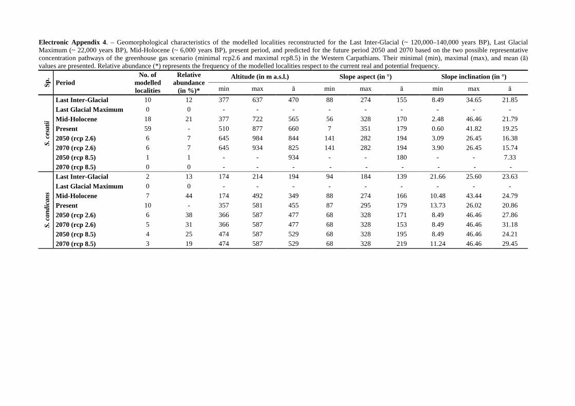
Electronic Appendix 4. – Geomorphological characteristics of the modelled localities reconstructed for the Last Inter-Glacial (~ 120,000–140,000 years BP), Last Glacial Maximum (~ 22,000 years BP), Mid-Holocene (~ 6,000 years BP), present period, and predicted for the future period 2050 and 2070 based on the two possible representative concentration pathways of the greenhouse gas scenario (minimal rcp2.6 and maximal rcp8.5) in the Western Carpathians. Their minimal (min), maximal (max), and mean (ā) values are presented. Relative abundance (*) represents the frequency of the modelled localities respect to the current real and potential frequency.
Sp.
Period No. of
modelled localities
Relative abundance
(in %)*
Altitude (in m a.s.l.) Slope aspect (in °) Slope inclination (in °)
min max ā min max ā min max ā
S. c
esat
ii
Last Inter-Glacial 10 12 377 637 470 88 274 155 8.49 34.65 21.85 Last Glacial Maximum 0 0 - - - - - - - - - Mid-Holocene 18 21 377 722 565 56 328 170 2.48 46.46 21.79 Present 59 - 510 877 660 7 351 179 0.60 41.82 19.25 2050 (rcp 2.6) 6 7 645 984 844 141 282 194 3.09 26.45 16.38 2070 (rcp 2.6) 6 7 645 934 825 141 282 194 3.90 26.45 15.74 2050 (rcp 8.5) 1 1 - - 934 - - 180 - - 7.33 2070 (rcp 8.5) 0 0 - - - - - - - - -
S. c
andi
cans
Last Inter-Glacial 2 13 174 214 194 94 184 139 21.66 25.60 23.63 Last Glacial Maximum 0 0 - - - - - - - - - Mid-Holocene 7 44 174 492 349 88 274 166 10.48 43.44 24.79 Present 10 - 357 581 455 87 295 179 13.73 26.02 20.86 2050 (rcp 2.6) 6 38 366 587 477 68 328 171 8.49 46.46 27.86 2070 (rcp 2.6) 5 31 366 587 477 68 328 153 8.49 46.46 31.18 2050 (rcp 8.5) 4 25 474 587 529 68 328 195 8.49 46.46 24.21 2070 (rcp 8.5) 3 19 474 587 529 68 328 219 11.24 46.46 29.45
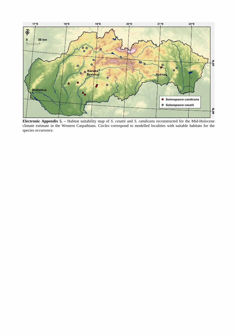
Electronic Appendix 5. – Habitat suitability map of S. cesatii and S. candicans reconstructed for the Mid-Holocene climate estimate in the Western Carpathians. Circles correspond to modelled localities with suitable habitats for the species occurrence.

Electronic Appendix 6. – Habitat suitability map of S. cesatii and S. candicans reconstructed for the Last Inter-Glacial climate estimate in the Western Carpathians. Circles correspond to modelled localities with suitable habitats for the species occurrence (likelihood of presence: 91–100 % for S. cesatii, 92 – 99 % for S. candicans).

Electronic Appendix 7. – Habitat suitability map of S. cesatii and S. candicans predicted for the year 2050 based on minimal representative concentration pathways of greenhouse gas scenario (rcp2.6). Circles correspond to modelled localities with suitable habitats for the species occurrence in the Western Carpathians (likelihood of presence: 91–100 % for S. cesatii, 92 – 99 % for S. candicans).
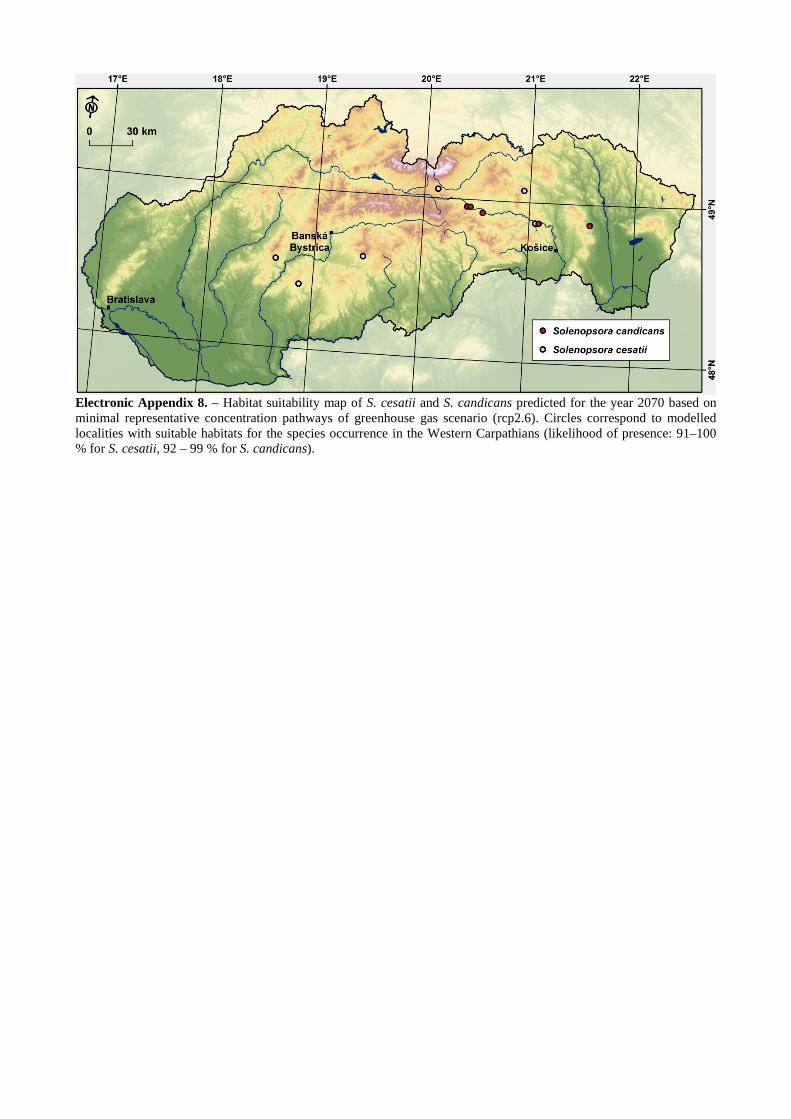
Electronic Appendix 8. – Habitat suitability map of S. cesatii and S. candicans predicted for the year 2070 based on minimal representative concentration pathways of greenhouse gas scenario (rcp2.6). Circles correspond to modelled localities with suitable habitats for the species occurrence in the Western Carpathians (likelihood of presence: 91–100 % for S. cesatii, 92 – 99 % for S. candicans).
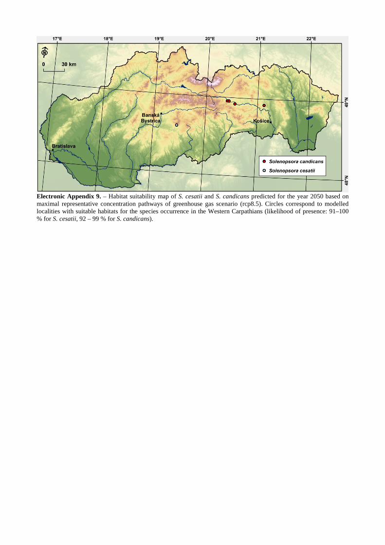
Electronic Appendix 9. – Habitat suitability map of S. cesatii and S. candicans predicted for the year 2050 based on maximal representative concentration pathways of greenhouse gas scenario (rcp8.5). Circles correspond to modelled localities with suitable habitats for the species occurrence in the Western Carpathians (likelihood of presence: 91–100 % for S. cesatii, 92 – 99 % for S. candicans).
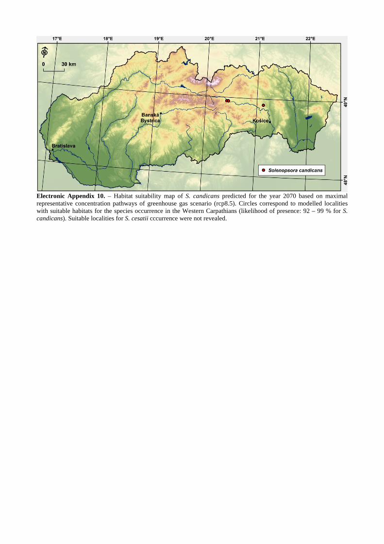
Electronic Appendix 10. – Habitat suitability map of S. candicans predicted for the year 2070 based on maximal representative concentration pathways of greenhouse gas scenario (rcp8.5). Circles correspond to modelled localities with suitable habitats for the species occurrence in the Western Carpathians (likelihood of presence: 92 – 99 % for S. candicans). Suitable localities for S. cesatii cccurrence were not revealed.