Embed Size (px)
DESCRIPTION
An overview of our FieldTRAKS Application Development Framework.
Citation preview
www.fieldtraks.ca
FieldTRAKS Web‐Based Mappingand Record Keeping
FieldTRAKS 2012 Technology Overview
www.f ie ldtraks .caCompany Services
FieldTRAKS Solutions Inc. (FSI) develops geospatial data management technology that leverages the ability to create dynamic and rich Internet applications using Microsoft Silverlight and Bing Maps.
The ability to customize FieldTRAKS technology to meet specific data collection and reporting requirements sets it apart from other GIS web mapping solutions.
End‐user solutions are easily customized through database configurations thus eliminating the need to create multiple software versions for different application needs.
FieldTRAKS applications work in any industry sector where there is a need to manage information about events that are related to a hierarchy of spatial or non‐spatial objects.
www.f ie ldtraks .caMarkets Sectors
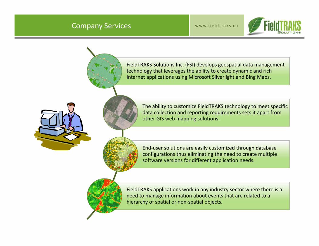
Other Spatial DataManagement Applications
• Golf Courses• Game Properties• + many others
FieldTRAKS Agriculture Record Keeping System (ARKS) FieldTRAKS Pipeline Manager
www.f ie ldtraks .ca
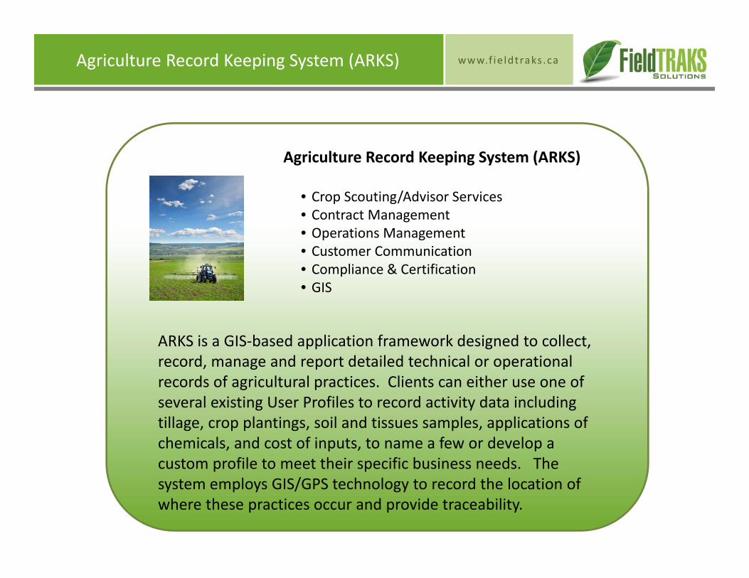
Agriculture Record Keeping System (ARKS)
Agriculture Record Keeping System (ARKS)
• Crop Scouting/Advisor Services• Contract Management• Operations Management• Customer Communication• Compliance & Certification• GIS
ARKS is a GIS‐based application framework designed to collect, record, manage and report detailed technical or operational records of agricultural practices. Clients can either use one of several existing User Profiles to record activity data including tillage, crop plantings, soil and tissues samples, applications of chemicals, and cost of inputs, to name a few or develop a custom profile to meet their specific business needs. The system employs GIS/GPS technology to record the location of where these practices occur and provide traceability.
www.f ie ldtraks .ca
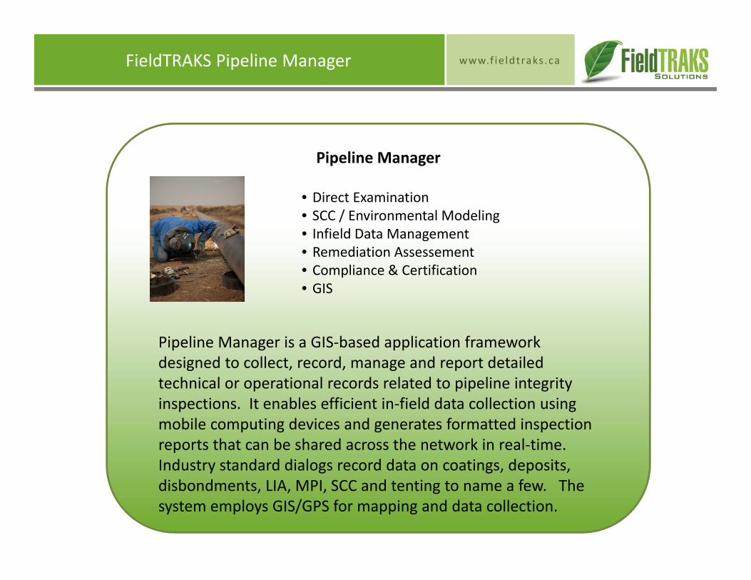
Pipeline Manager
FieldTRAKS Pipeline Manager
• Direct Examination• SCC / Environmental Modeling• Infield Data Management• Remediation Assessement• Compliance & Certification• GIS
Pipeline Manager is a GIS‐based application framework designed to collect, record, manage and report detailed technical or operational records related to pipeline integrity inspections. It enables efficient in‐field data collection using mobile computing devices and generates formatted inspection reports that can be shared across the network in real‐time.Industry standard dialogs record data on coatings, deposits, disbondments, LIA, MPI, SCC and tenting to name a few. The system employs GIS/GPS for mapping and data collection.
www.f ie ldtraks .caSimplicity and Power
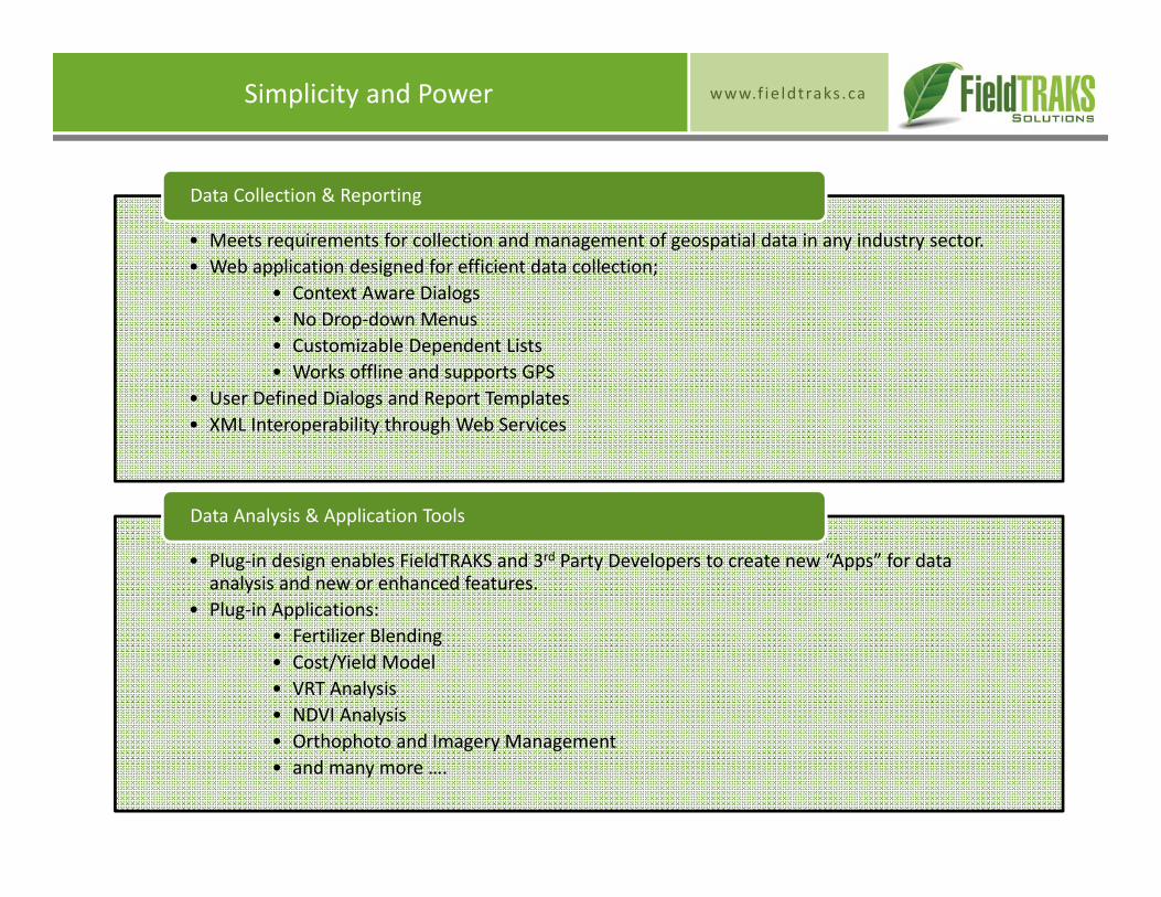
• Meets requirements for collection and management of geospatial data in any industry sector.• Web application designed for efficient data collection;
• Context Aware Dialogs• No Drop‐down Menus• Customizable Dependent Lists• Works offline and supports GPS
• User Defined Dialogs and Report Templates• XML Interoperability through Web Services
Data Collection & Reporting
• Plug‐in design enables FieldTRAKS and 3rd Party Developers to create new “Apps” for data analysis and new or enhanced features.
• Plug‐in Applications:• Fertilizer Blending• Cost/Yield Model• VRT Analysis• NDVI Analysis• Orthophoto and Imagery Management• and many more ….
Data Analysis & Application Tools

www.f ie ldtraks .caArchitecture Overview
Design Features
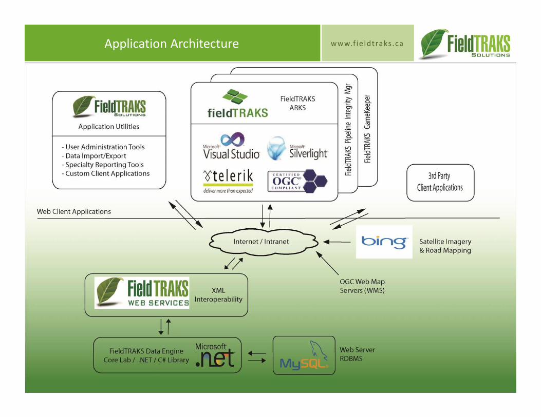
Utilizes a modern technology framework that that employs open standards and Web Services for mapping and data exchanges.
Profiles define the hierarchy of spatial/non‐spatial objects, their associated events (e.g., activities) and their data properties.
Profiles are configured entirely through the web server database.
“Plug‐in” design allows custom code to be added to provide additional functionality for data analysis and custom features.
Design Advantages
FieldTRAKS can be easily integrated with other enterprise business systems to provide 2‐way exchange of GIS and activity data.
Users define how their data is organized and what data is recorded. FieldTRAKS is designed to adapt to the existing business data requirements of the client.
Changes to User Profiles and system configurations are do not impact the core application code and therefore are immediately available and have minimum system risk.
The Plug‐in capability = Power! Developers can create new applications that can consume FieldTRAKS data and provide analytic tools or new functionality. The Plug‐ins remain independent of the core application code and pose no risk to other system users.
FieldTRAKS provides a flexible and powerful application architecture that can be deployed in applications wherever there is a need for collecting and managing spatial information. FieldTRAKS provides a flexible and powerful application architecture that can be deployed in applications wherever there is a need for collecting and managing spatial information.
www.f ie ldtraks .caApplication Architecture
www.f ie ldtraks .caFieldTRAKS Web Services
FieldTRAKS Web
Services
XML Web Service (.asmx)
Web Service
Definition
Web Client Application
User Profile (MySQL)
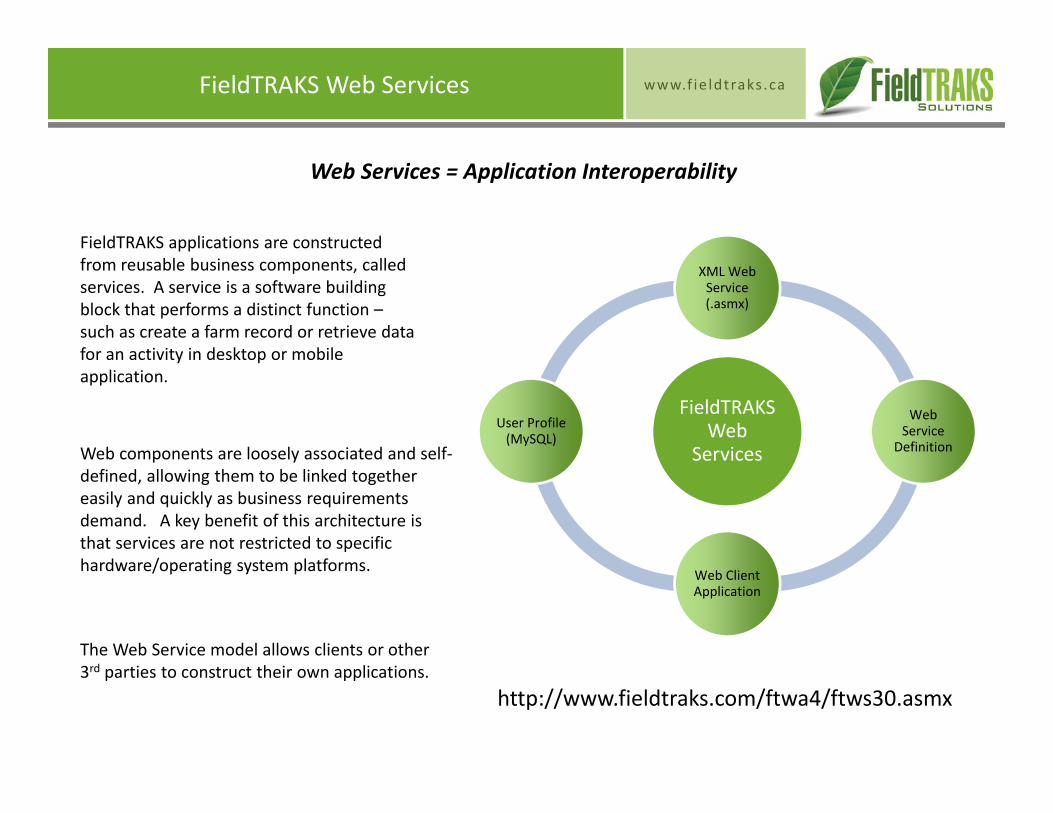
FieldTRAKS applications are constructed from reusable business components, called services. A service is a software building block that performs a distinct function –such as create a farm record or retrieve data for an activity in desktop or mobile application.
Web components are loosely associated and self‐defined, allowing them to be linked together easily and quickly as business requirements demand. A key benefit of this architecture is that services are not restricted to specific hardware/operating system platforms.
Web Services = Application Interoperability
The Web Service model allows clients or other 3rd parties to construct their own applications.
http://www.fieldtraks.com/ftwa4/ftws30.asmx
www.f ie ldtraks .caWhat is FieldTRAKS ARKS ™?
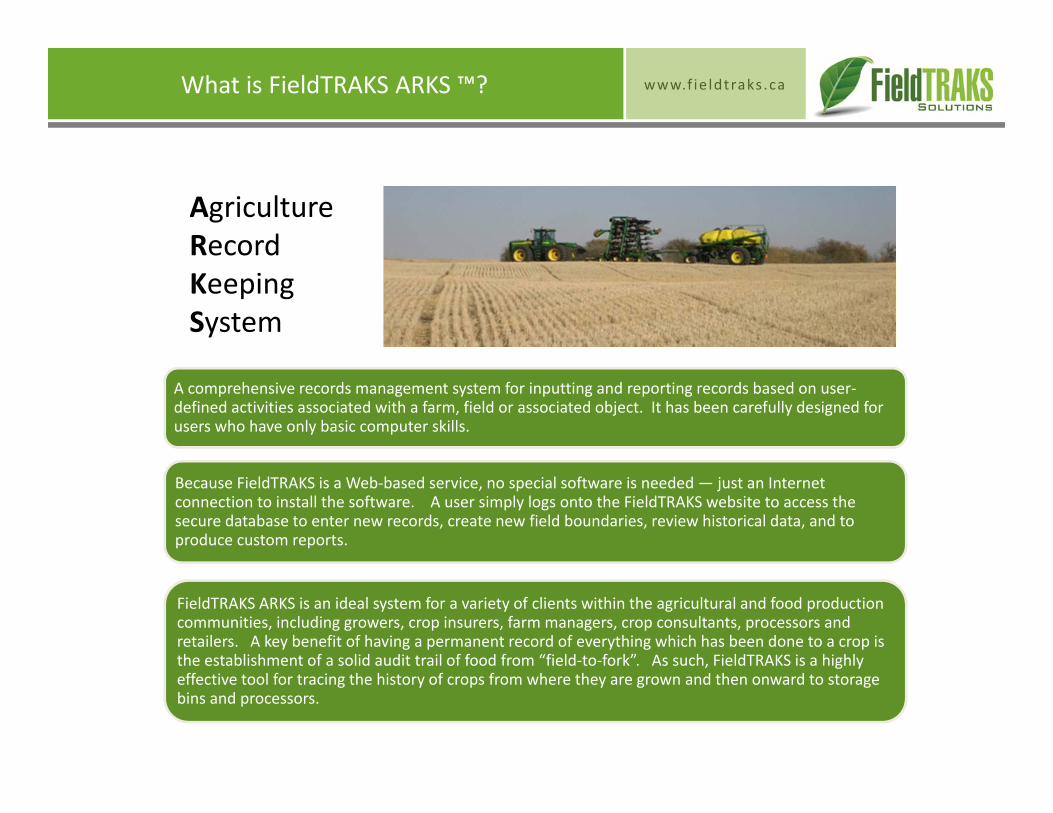
A comprehensive records management system for inputting and reporting records based on user‐defined activities associated with a farm, field or associated object. It has been carefully designed for users who have only basic computer skills.
Because FieldTRAKS is a Web‐based service, no special software is needed — just an Internet connection to install the software. A user simply logs onto the FieldTRAKS website to access the secure database to enter new records, create new field boundaries, review historical data, and to produce custom reports.
FieldTRAKS ARKS is an ideal system for a variety of clients within the agricultural and food production communities, including growers, crop insurers, farm managers, crop consultants, processors and retailers. A key benefit of having a permanent record of everything which has been done to a crop is the establishment of a solid audit trail of food from “field‐to‐fork”. As such, FieldTRAKS is a highly effective tool for tracing the history of crops from where they are grown and then onward to storage bins and processors.
AgricultureRecordKeepingSystem
www.f ie ldtraks .caARKS User Profile Configurations
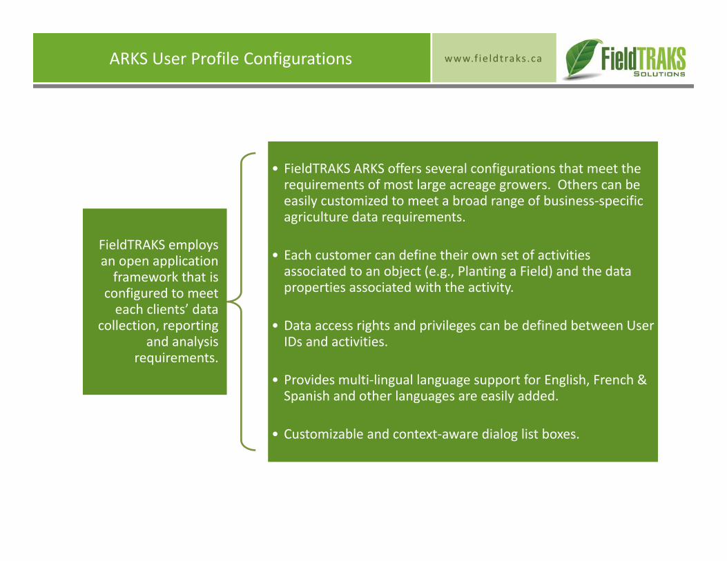
FieldTRAKS employs an open application framework that is
configured to meet each clients’ data
collection, reporting and analysis
requirements.
• FieldTRAKS ARKS offers several configurations that meet the requirements of most large acreage growers. Others can be easily customized to meet a broad range of business‐specific agriculture data requirements.
• Each customer can define their own set of activities associated to an object (e.g., Planting a Field) and the data properties associated with the activity.
• Data access rights and privileges can be defined between User IDs and activities.
• Provides multi‐lingual language support for English, French & Spanish and other languages are easily added.
• Customizable and context‐aware dialog list boxes.
www.f ie ldtraks .caARKS User Profile Configurations
Farm
•Notes
Field
• Nutrients• Tillage• Field Notes
Crop
• Fertilizer• Seeding• Chemicals• Harvest• Samples
Scouting
• Diseases• Weeds• Insects• Damages• Moisture
Farm
• Notes
Contract
• Contract• Tillage• Field Notes
Field
• Fertilizer• Seeding• Chemicals• Harvest
Sample
• Tissue• Soil
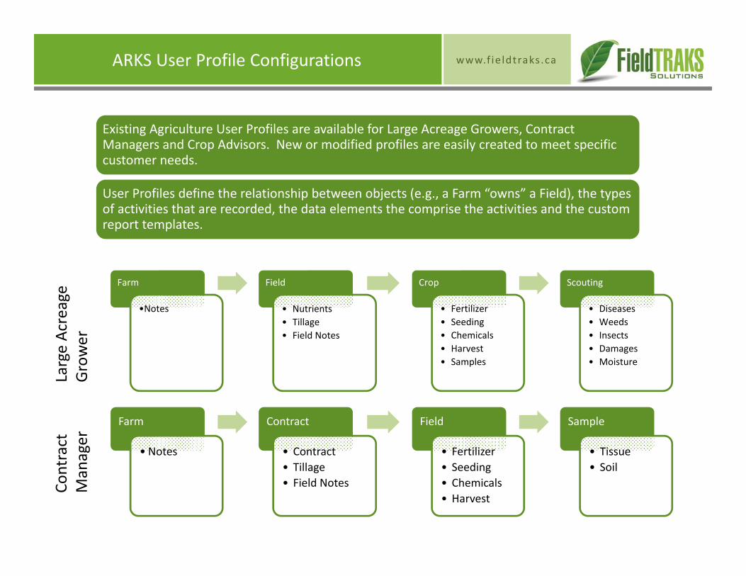
Existing Agriculture User Profiles are available for Large Acreage Growers, Contract Managers and Crop Advisors. New or modified profiles are easily created to meet specific customer needs.
User Profiles define the relationship between objects (e.g., a Farm “owns” a Field), the types of activities that are recorded, the data elements the comprise the activities and the custom report templates.
Large Acreage
Grower
Contract
Manager
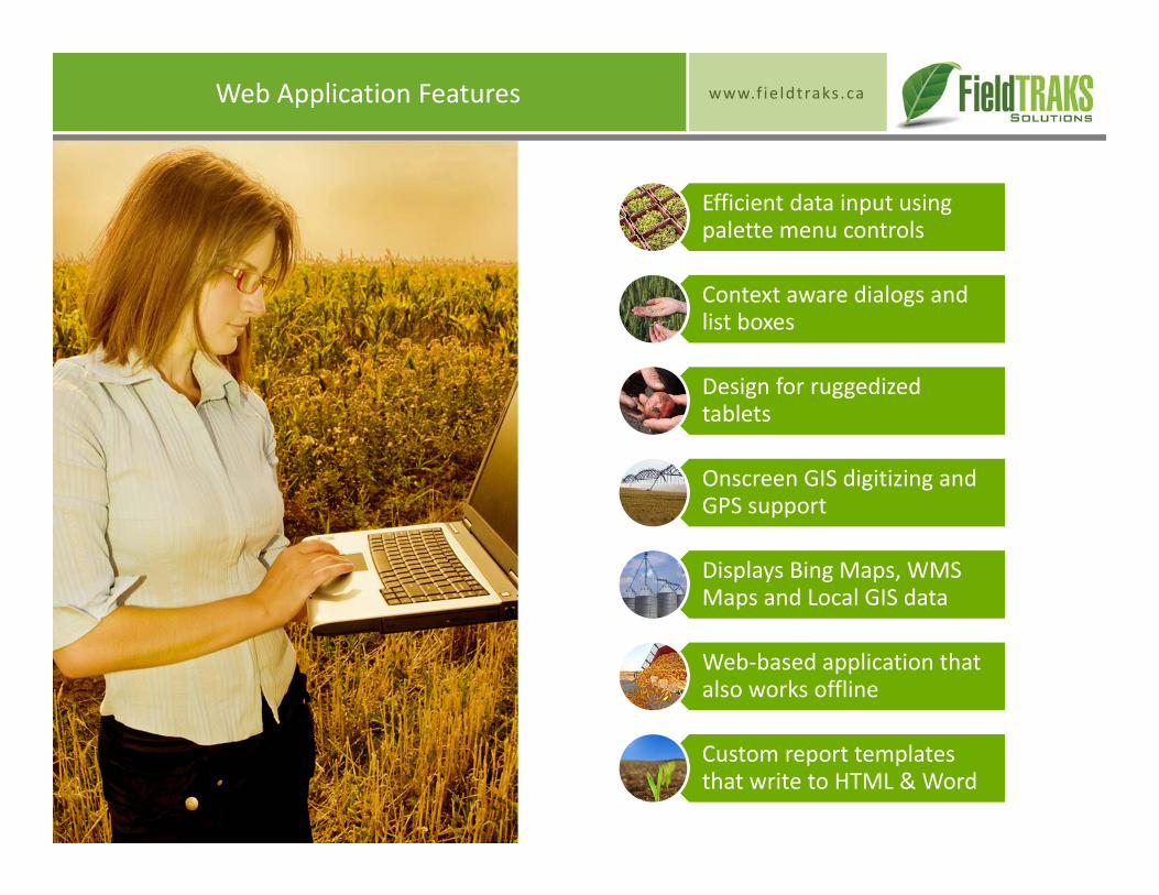
www.f ie ldtraks .caWeb Application Features
Efficient data input using palette menu controls
Context aware dialogs and list boxes
Design for ruggedized tablets
Onscreen GIS digitizing and GPS support
Displays Bing Maps, WMS Maps and Local GIS data
Web‐based application that also works offline
Custom report templates that write to HTML & Word
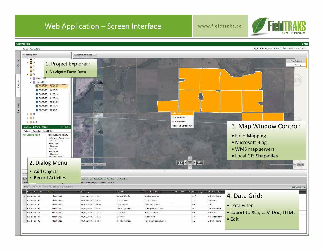
www.f ie ldtraks .caWeb Application – Screen Interface
4. Data Grid:• Data Filter• Export to XLS, CSV, Doc, HTML• Edit
1. Project Explorer:• Navigate Farm Data
3. Map Window Control:• Field Mapping•Microsoft Bing•WMS map servers• Local GIS Shapefiles
2. Dialog Menu:• Add Objects• Record Activites
www.f ie ldtraks .caWeb Application – Palette Menus
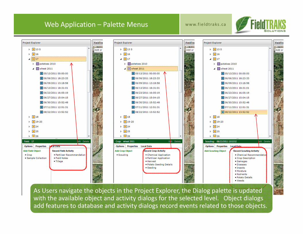
As Users navigate the objects in the Project Explorer, the Dialog palette is updated with the available object and activity dialogs for the selected level. Object dialogs add features to database and activity dialogs record events related to those objects.
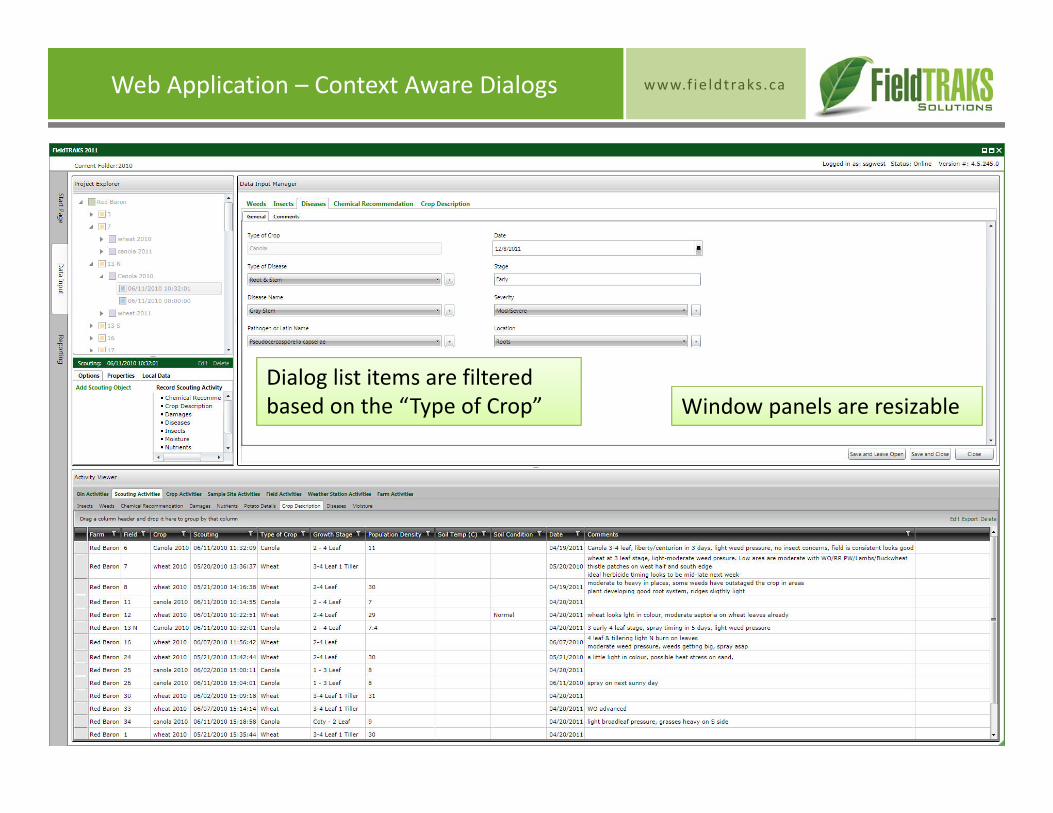
www.f ie ldtraks .caWeb Application – Context Aware Dialogs
Dialog list items are filtered based on the “Type of Crop” Window panels are resizable
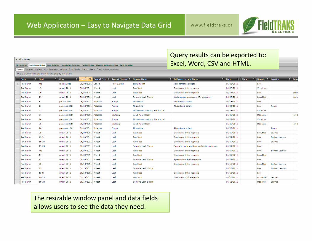
www.f ie ldtraks .caWeb Application – Easy to Navigate Data Grid
Query results can be exported to: Excel, Word, CSV and HTML.
The resizable window panel and data fields allows users to see the data they need.
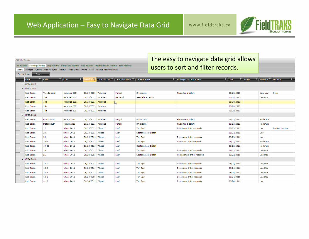
www.f ie ldtraks .caWeb Application – Easy to Navigate Data Grid
The easy to navigate data grid allows users to sort and filter records.
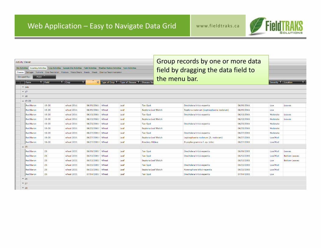
www.f ie ldtraks .caWeb Application – Easy to Navigate Data Grid
Group records by one or more data field by dragging the data field to the menu bar.
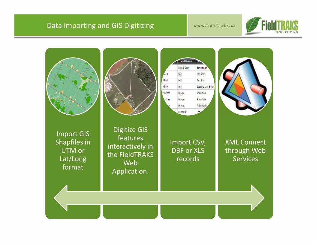
www.f ie ldtraks .caData Importing and GIS Digitizing
Import GIS Shapfiles in UTM or Lat/Long format
Digitize GIS features
interactively in the FieldTRAKS
Web Application.
Import CSV, DBF or XLS records
XML Connect through Web
Services
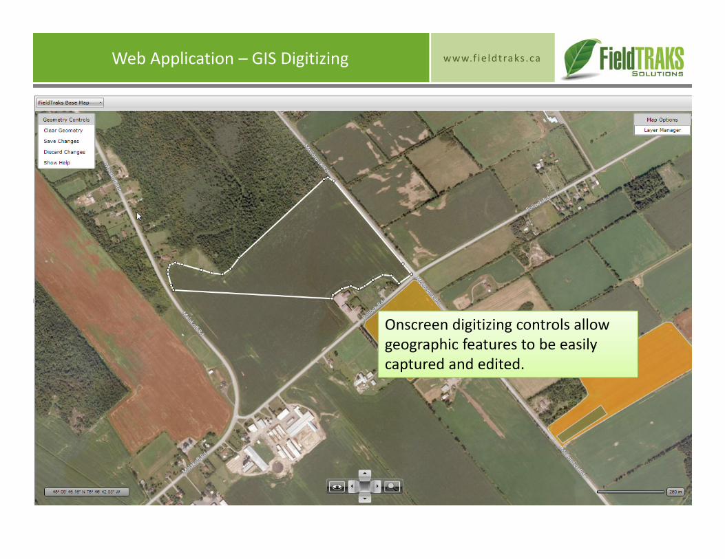
www.f ie ldtraks .caWeb Application – GIS Digitizing
Onscreen digitizing controls allow geographic features to be easily captured and edited.

www.f ie ldtraks .caWeb Application – GIS Digitizing
Digitizing controls support complex polygons, polylines and point features and can be imported to other GIS software.
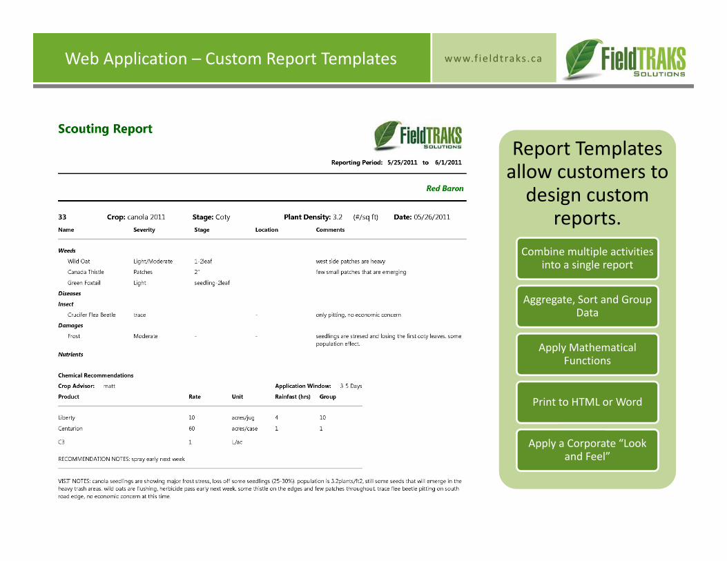
www.f ie ldtraks .caWeb Application – Custom Report Templates
Report Templates allow customers to design custom
reports.Combine multiple activities
into a single report
Aggregate, Sort and Group Data
Apply Mathematical Functions
Print to HTML or Word
Apply a Corporate “Look and Feel”
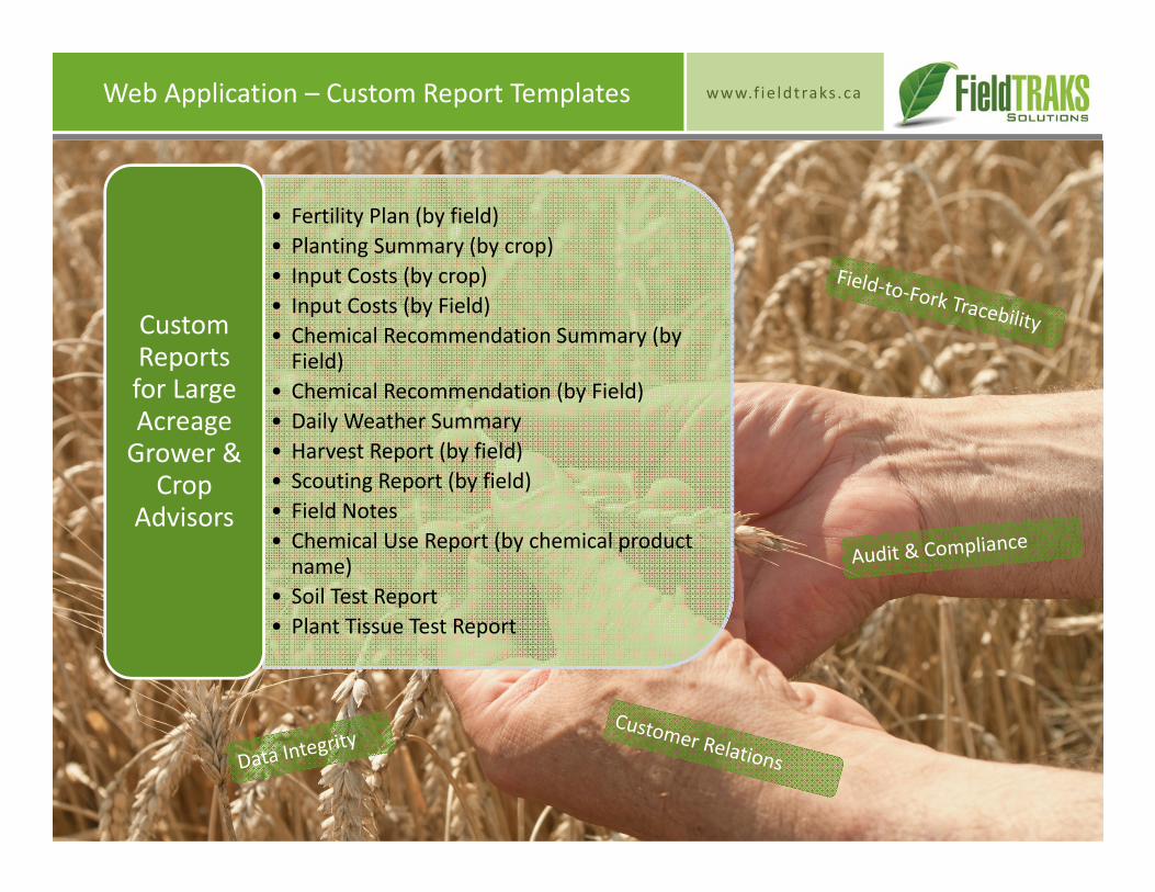
www.f ie ldtraks .caWeb Application – Custom Report Templates
• Fertility Plan (by field)• Planting Summary (by crop)• Input Costs (by crop)• Input Costs (by Field)• Chemical Recommendation Summary (by Field)
• Chemical Recommendation (by Field)• Daily Weather Summary• Harvest Report (by field)• Scouting Report (by field)• Field Notes• Chemical Use Report (by chemical product name)
• Soil Test Report• Plant Tissue Test Report
Custom Reports for Large Acreage Grower & Crop
Advisors
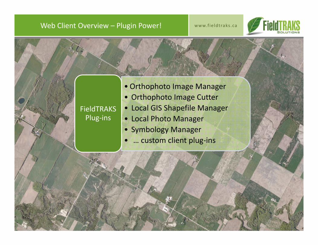
www.f ie ldtraks .caWeb Client Overview – Plugin Power!
• Orthophoto Image Manager• Orthophoto Image Cutter• Local GIS Shapefile Manager• Local Photo Manager• Symbology Manager• … custom client plug‐ins
FieldTRAKS Plug‐ins
www.f ie ldtraks .caWeb Client Overview – Plugin Power!
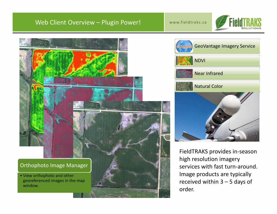
GeoVantage Imagery Service
NDVI
Near Infrared
Natural Color
FieldTRAKS provides in‐season high resolution imagery services with fast turn‐around. Image products are typically received within 3 – 5 days of order.
Orthophoto Image Manager
• View orthophoto and other georeferenced images in the map window.
www.f ie ldtraks .caWeb Client Overview – Plugin Power!
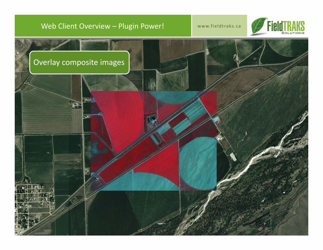
Overlay composite images
www.f ie ldtraks .caWeb Client Overview – Plugin Power!
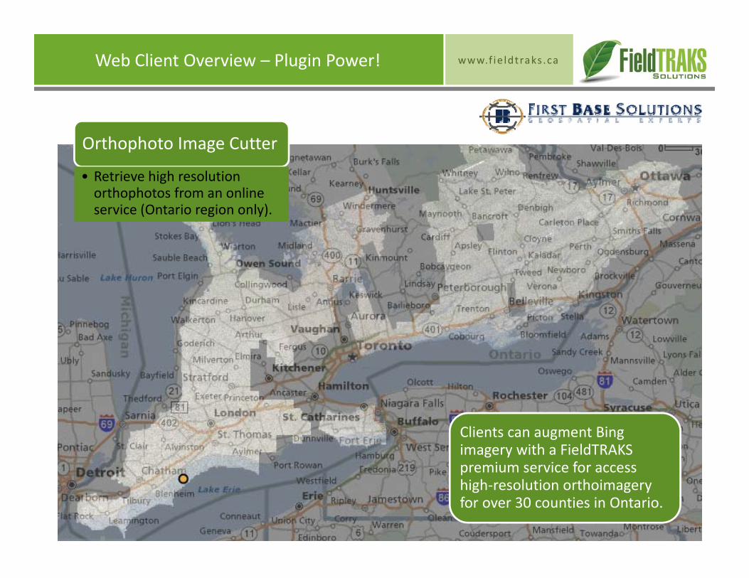
Clients can augment Bing imagery with a FieldTRAKS premium service for access high‐resolution orthoimagery for over 30 counties in Ontario.
Orthophoto Image Cutter
• Retrieve high resolution orthophotos from an online service (Ontario region only).
www.f ie ldtraks .caWeb Client Overview – Plugin Power!
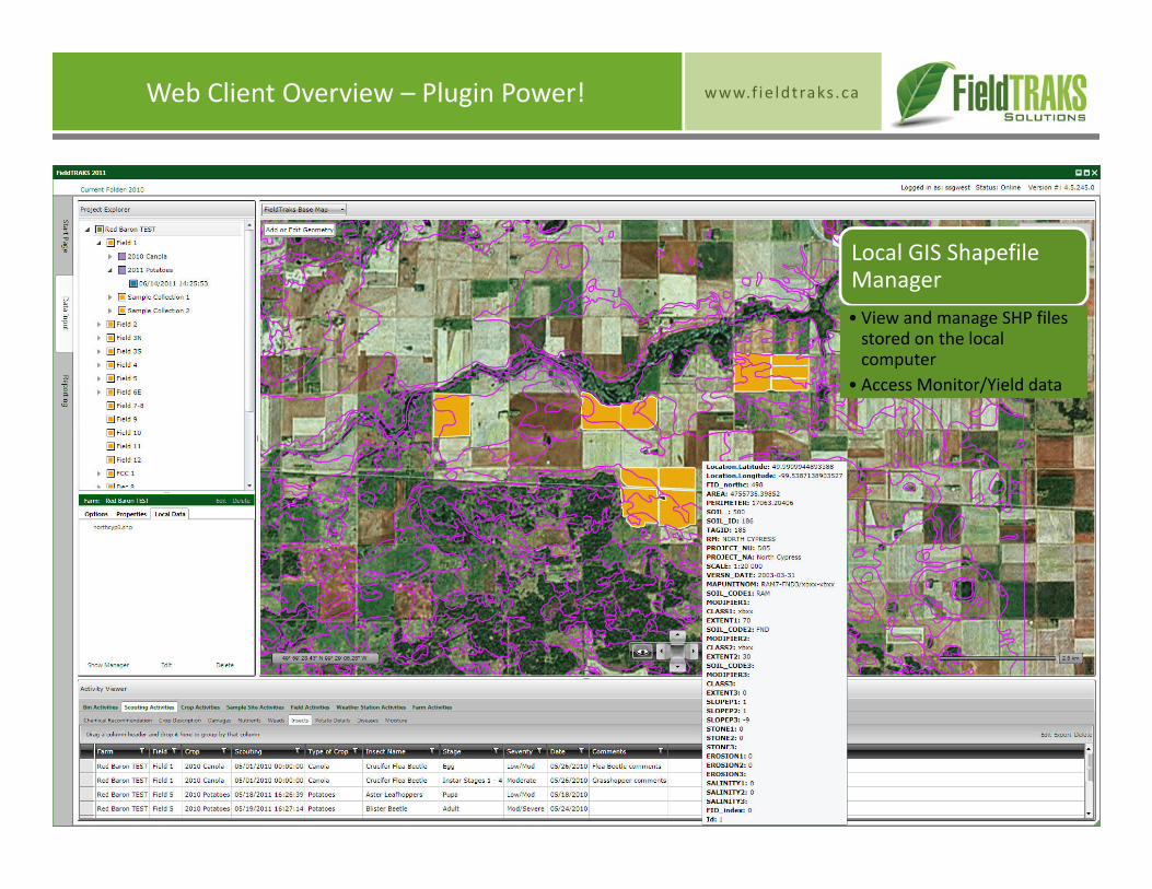
Local GIS Shapefile Manager• View and manage SHP files stored on the local computer
• Access Monitor/Yield data
www.f ie ldtraks .caWeb Client Overview – Plugin Power!
Local GIS Shapefile Manager• View and manage SHP files stored on the local computer
• Access Monitor/Yield data
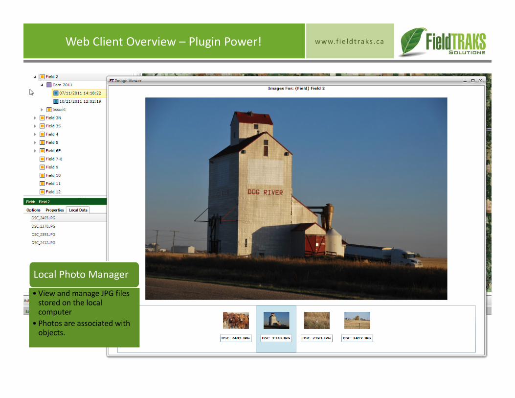
Local Photo Manager
• View and manage JPG files stored on the local computer
• Photos are associated with objects.
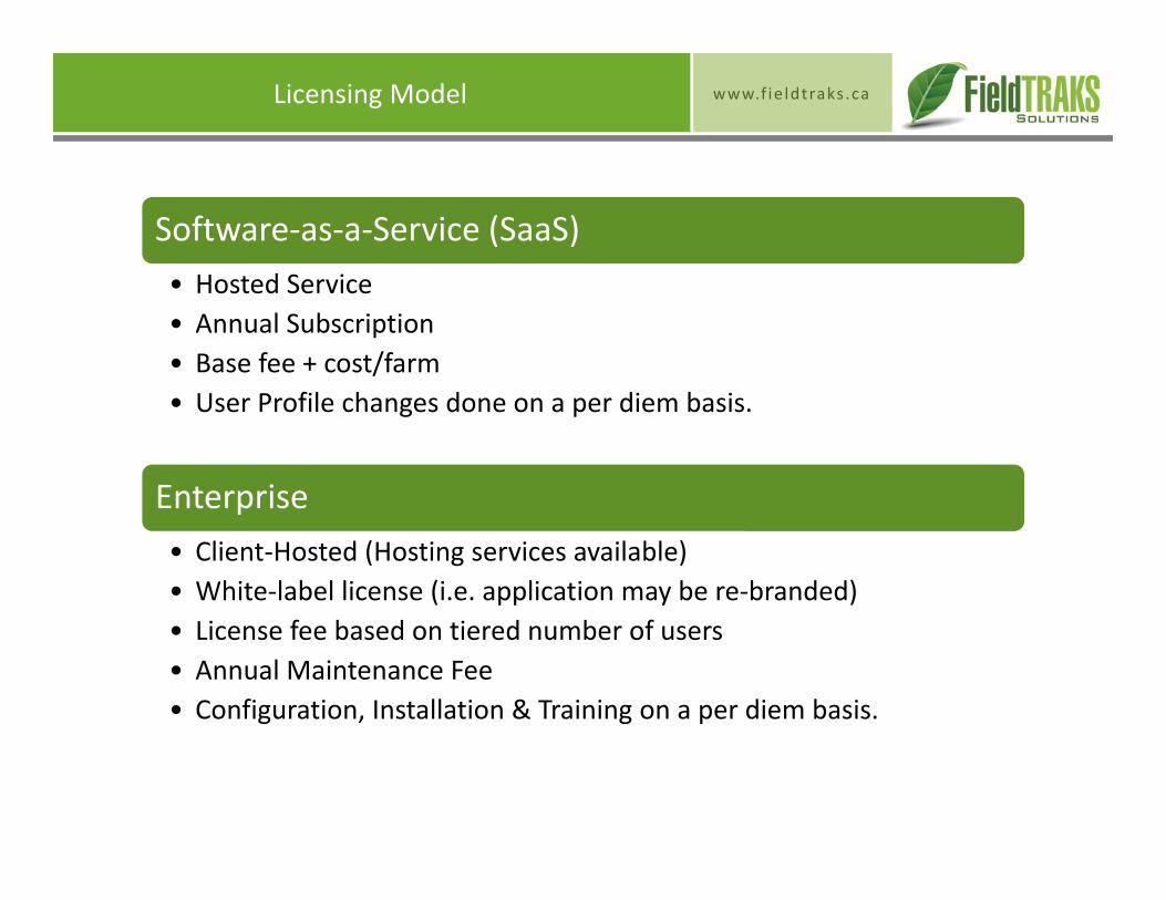
www.f ie ldtraks .caLicensing Model
Software‐as‐a‐Service (SaaS)• Hosted Service• Annual Subscription• Base fee + cost/farm• User Profile changes done on a per diem basis.
Enterprise• Client‐Hosted (Hosting services available)• White‐label license (i.e. application may be re‐branded)• License fee based on tiered number of users• Annual Maintenance Fee• Configuration, Installation & Training on a per diem basis.

www.f ie ldtraks .caPrinted Advertisement
For more information, please contact:
Dave [email protected]: (613) 489-0550 X401Cell: (613) 291-2310
FieldTRAKS Solutions Inc.6367 McCordick RoadNorth Gower, OntarioK0A 2T0