Embed Size (px)
Citation preview
O‘ahu Office P.O. Box 1114 Kailua, Hawai‘i 96734 Ph.: (808) 262-9972 Fax: (808) 262-4950
www.culturalsurveys.com
Maui Office 1860 Main St. Wailuku, Hawai‘i 96793 Ph.: (808) 242-9882 Fax: (808) 244-1994
Final
Archaeological Monitoring Plan for the Kawainui Marsh Wetland Restoration and
Habitat Enhancement Project, Kailua Ahupua‘a, Ko‘olaupoko District, O‘ahu
TMKs: [1] 4-2-013:005 (por.), 022 (por.), and 043 (por.)
Prepared for Helber Hastert and Fee, Planners, Inc.
Prepared by Trevor M Yucha, B.S.,
David W. Shideler M.A., and
Hallett H. Hammatt, Ph.D.
Cultural Surveys Hawai‘i, Inc. Kailua, Hawai‘i
(Job Code: KAILUA 54
June 2015
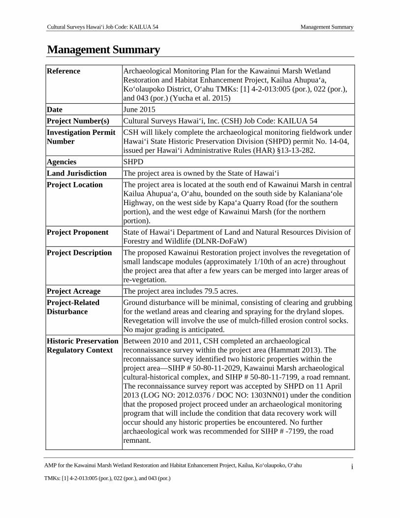
Cultural Surveys Hawai‘i Job Code: KAILUA 54 Management Summary
AMP for the Kawainui Marsh Wetland Restoration and Habitat Enhancement Project, Kailua, Ko‘olaupoko, O‘ahu i
TMKs: [1] 4-2-013:005 (por.), 022 (por.), and 043 (por.)
Management Summary
Reference Archaeological Monitoring Plan for the Kawainui Marsh Wetland Restoration and Habitat Enhancement Project, Kailua Ahupua‘a, Ko‘olaupoko District, O‘ahu TMKs: [1] 4-2-013:005 (por.), 022 (por.), and 043 (por.) (Yucha et al. 2015)
Date June 2015
Project Number(s) Cultural Surveys Hawai‘i, Inc. (CSH) Job Code: KAILUA 54
Investigation Permit Number
CSH will likely complete the archaeological monitoring fieldwork under Hawai‘i State Historic Preservation Division (SHPD) permit No. 14-04, issued per Hawai‘i Administrative Rules (HAR) §13-13-282.
Agencies SHPD
Land Jurisdiction The project area is owned by the State of Hawai‘i
Project Location The project area is located at the south end of Kawainui Marsh in central Kailua Ahupua‘a, O‘ahu, bounded on the south side by Kalaniana‘ole Highway, on the west side by Kapa‘a Quarry Road (for the southern portion), and the west edge of Kawainui Marsh (for the northern portion).
Project Proponent State of Hawai‘i Department of Land and Natural Resources Division of Forestry and Wildlife (DLNR-DoFaW)
Project Description The proposed Kawainui Restoration project involves the revegetation of small landscape modules (approximately 1/10th of an acre) throughout the project area that after a few years can be merged into larger areas of re-vegetation.
Project Acreage The project area includes 79.5 acres.
Project-Related Disturbance
Ground disturbance will be minimal, consisting of clearing and grubbing for the wetland areas and clearing and spraying for the dryland slopes. Revegetation will involve the use of mulch-filled erosion control socks. No major grading is anticipated.
Historic Preservation Regulatory Context
Between 2010 and 2011, CSH completed an archaeological reconnaissance survey within the project area (Hammatt 2013). The reconnaissance survey identified two historic properties within the project area—SIHP # 50-80-11-2029, Kawainui Marsh archaeological cultural-historical complex, and SIHP # 50-80-11-7199, a road remnant. The reconnaissance survey report was accepted by SHPD on 11 April 2013 (LOG NO: 2012.0376 / DOC NO: 1303NN01) under the condition that the proposed project proceed under an archaeological monitoring program that will include the condition that data recovery work will occur should any historic properties be encountered. No further archaeological work was recommended for SIHP # -7199, the road remnant.
Cultural Surveys Hawai‘i Job Code: KAILUA 54 Management Summary
AMP for the Kawainui Marsh Wetland Restoration and Habitat Enhancement Project, Kailua, Ko‘olaupoko, O‘ahu ii
TMKs: [1] 4-2-013:005 (por.), 022 (por.), and 043 (por.)
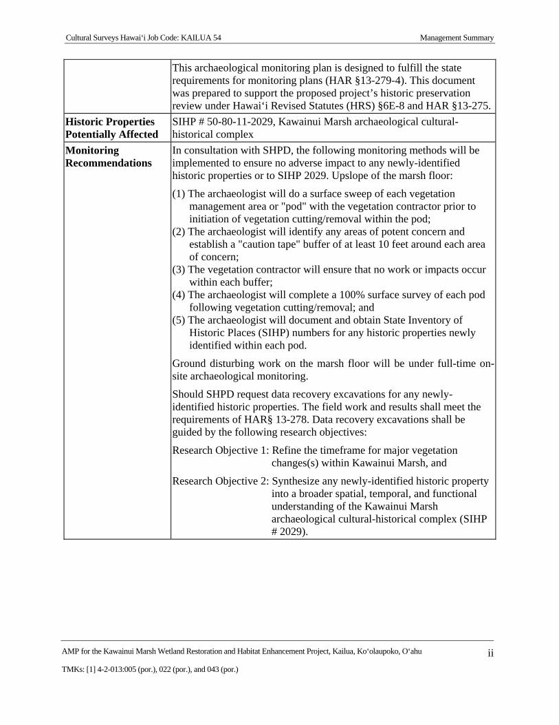
This archaeological monitoring plan is designed to fulfill the state requirements for monitoring plans (HAR §13-279-4). This document was prepared to support the proposed project’s historic preservation review under Hawai‘i Revised Statutes (HRS) §6E-8 and HAR §13-275.
Historic Properties Potentially Affected
SIHP # 50-80-11-2029, Kawainui Marsh archaeological cultural-historical complex
Monitoring Recommendations
In consultation with SHPD, the following monitoring methods will be implemented to ensure no adverse impact to any newly-identified historic properties or to SIHP 2029. Upslope of the marsh floor:
(1) The archaeologist will do a surface sweep of each vegetation management area or "pod" with the vegetation contractor prior to initiation of vegetation cutting/removal within the pod;
(2) The archaeologist will identify any areas of potent concern and establish a "caution tape" buffer of at least 10 feet around each area of concern;
(3) The vegetation contractor will ensure that no work or impacts occur within each buffer;
(4) The archaeologist will complete a 100% surface survey of each pod following vegetation cutting/removal; and
(5) The archaeologist will document and obtain State Inventory of Historic Places (SIHP) numbers for any historic properties newly identified within each pod.
Ground disturbing work on the marsh floor will be under full-time on-site archaeological monitoring.
Should SHPD request data recovery excavations for any newly-identified historic properties. The field work and results shall meet the requirements of HAR§ 13-278. Data recovery excavations shall be guided by the following research objectives:
Research Objective 1: Refine the timeframe for major vegetation changes(s) within Kawainui Marsh, and
Research Objective 2: Synthesize any newly-identified historic property into a broader spatial, temporal, and functional understanding of the Kawainui Marsh archaeological cultural-historical complex (SIHP # 2029).
Cultural Surveys Hawai‘i Job Code: KAILUA 54
AMP for the Kawainui Marsh Wetland Restoration and Habitat Enhancement Project, Kailua, Ko‘olaupoko, O‘ahu iii
TMKs: [1] 4-2-013:005 (por.), 022 (por.), and 043 (por.)
Table of Contents Management Summary ............................................................................................................ i
Section 1 Introduction ............................................................................................................. 1
1.1 Project Background ....................................................................................................................... 1 1.2 Historic Preservation Regulatory Context and Document Purpose ............................................... 1 1.3 Environmental Setting ................................................................................................................... 7
1.3.1 Natural Environment............................................................................................................... 7 1.3.2 Built Environment .................................................................................................................. 7
Section 2 Background Research ............................................................................................. 9
2.1 Traditional and Historical Background .......................................................................................... 9 2.1.1 Mythological and Traditional Accounts ................................................................................. 9 2.1.2 Early Historic Period ............................................................................................................ 16 2.1.3 Mid- to Late 1800s ................................................................................................................ 17 2.1.4 1900s ..................................................................................................................................... 22
2.2 Previous Archaeological Research in Kailua Ahupua‘a .............................................................. 29 2.3 Most Relevant Archaeological Reports Conducted in Kawainui Marsh ..................................... 34
2.3.1 Ewart and Tuggle (1977) ...................................................................................................... 34
Section 3 Archaeological Monitoring Provisions ................................................................ 58
Section 4 References Cited .................................................................................................... 61
Appendix A SHPD Correspondence .................................................................................... 69
Cultural Surveys Hawai‘i Job Code: KAILUA 54
AMP for the Kawainui Marsh Wetland Restoration and Habitat Enhancement Project, Kailua, Ko‘olaupoko, O‘ahu iv
TMKs: [1] 4-2-013:005 (por.), 022 (por.), and 043 (por.)
List of Figures Figure 1. Portion of the 1998 Mokapu Point USGS 7.5-Minute Series topographic quadrangle,
showing the location of the project area ...........................................................................2 Figure 2. Tax Map Key (TMK) 4-2-13, showing the location of the project area ..........................3 Figure 3. 2005 USGS aerial photograph showing the location of the project area (USGS
Orthoimagery 2005) ..........................................................................................................4 Figure 4. Kawainui Marsh Restoration Phase 1 Plan (courtesy of client) .......................................5 Figure 5. Close-up of the Kawainui Marsh Restoration Phase 1 Plan (courtesy of client) .............6 Figure 6. Overlay of the Soil Survey of the State of Hawaii (Foote et al. 1972), indicating
sediment types within and surrounding the current project area (source: Soils Survey Geographic Database [SSUGRO] 2001, U.S. Department of Agriculture) ......................8
Figure 7. 1881 Oahu Island Hawaiian Government survey map showing the location of the current project area (Covington 1881) ............................................................................18
Figure 8. 1899 W.E. Wall map showing the location of the current project area ..........................21 Figure 9. 1902 Hawaii Territory survey map by W.E. Wall showing the location of the current
project area ......................................................................................................................23 Figure 10. 1919 Fire Control map, Waimanalo Quadrangle showing the location of the current
project area ...................................................................................................................24 Figure 11. 1928 Mokapu USGS quadrangle, showing the location of the current project area ....26 Figure 12. 1943 War Department map, Kaneohe Quadrangle showing the location of the
current project area ......................................................................................................27 Figure 13. 1952 Army Map Service map, Mokapu Quadrangle showing the location of the
current project area ......................................................................................................28 Figure 14. 1998 Mokapu USGS 7.5-minute topographic quandrangle showing the location of
previous archaeological studies in the vicinity of the current project area (note the project area is also considered to be the Hammatt 2013 study area) ...........................33
Figure 15. Ewart and Tuggle (1977) study area map showing the location of the nine archaeological sites located with reference to the present study area (outlined in red; only their Site 7 is near the present study area) ....................................................36
Figure 16. Map showing location of Cordy (1977a:35) Sites 1 through 6 on the Kūkanono-Pōhākupu slope ............................................................................................................38
Figure 17. Cordy (1978: Figure 9) map of extent of Site 7 ...........................................................40 Figure 18. Clark (1980) project area map showing project segments I through IV (present
project area outlined in red) .........................................................................................42 Figure 19. Location map for Clark’s Cluster 12 that Clark identified with BPBM Site 50-Oa-
G6-36 (from Clark 1989:25) (present project area outlined in red) .............................43 Figure 20. BPBM Site 50-Oa-G6-36 (a.k.a. Cluster 12) southeast corner of Feature 1, marsh
in foreground and to the left (from Clark 1980:50) .......................................................45 Figure 21. Ceramic bowl fragment recovered from surface of BPBM Site 50-Oa-G6-36 (a.k.a.
Cluster 12) (from Clark 1980:70) ................................................................................45 Figure 22. Kawainui site location map from Allen-Wheeler (1981:19); her work was within
the black rectangle on the southeast side of the marsh (note distance between site “36” and Ewart and Tuggle Site 7) ..............................................................................47
Cultural Surveys Hawai‘i Job Code: KAILUA 54
AMP for the Kawainui Marsh Wetland Restoration and Habitat Enhancement Project, Kailua, Ko‘olaupoko, O‘ahu v
TMKs: [1] 4-2-013:005 (por.), 022 (por.), and 043 (por.)
Figure 23. Portion of USGS quadrangle showing Athens (1983a) project area of BPBM Site #s 50-Oa-G6-32 and 50-Oa-G6-41 ....................................................................................50
Figure 24. Map showing Athens (1983a) project area of BPBM Site #s 50-Oa-G6-32 and 50- Oa-G6-41 .....................................................................................................................50
Figure 25. Location of Erkelens (1993) project area on the Kūkanono slope ...............................53 Figure 26. Detail of Erkelens (1993) project area on the Kūkanono slope ....................................53 Figure 27. TMK: 4-2-013 showing location of Mann and Hammatt (2003), Test Trenches 1
and 2 .............................................................................................................................56
List of Tables Table 1. Land Commission Awards Located within the Current Project Area .............................20 Table 2. Archaeological Studies at Kailua Ahupu‘a, O‘ahu ..........................................................30 Table 3. Brief Summary of Nine Sites Reported by Ewart and Tuggle (1977:18-25) ..................35 Table 4. Brief Summary of Sites Reported by Cordy (1977a:34-42) ............................................37 Table 5. Comparative Listing of “Archaeological Loci” Reported in Clark (1980:24) (note Site
50-Oa-G6-36 and Ewart and Tuggle Site 7 are correlated as the same) ..........................41 Table 6. Kawainui Site Nomenclature Correlation Table from Allen-Wheeler (1981:20) (note
BPBM Site # 50-Oa-G6-36 and Ewart and Tuggle Site 7 are correlated as the same) ....48 Table 7. Radiocarbon Dates from the Slopes around Kawainui (Erkelens 1993:54) ....................52
Cultural Surveys Hawai‘i Job Code: KAILUA 54 Introduction
AMP for the Kawainui Marsh Wetland Restoration and Habitat Enhancement Project, Kailua, Ko‘olaupoko, O‘ahu 1
TMKs: [1] 4-2-013:005 (por.), 022 (por.), and 043 (por.)
Section 1 Introduction
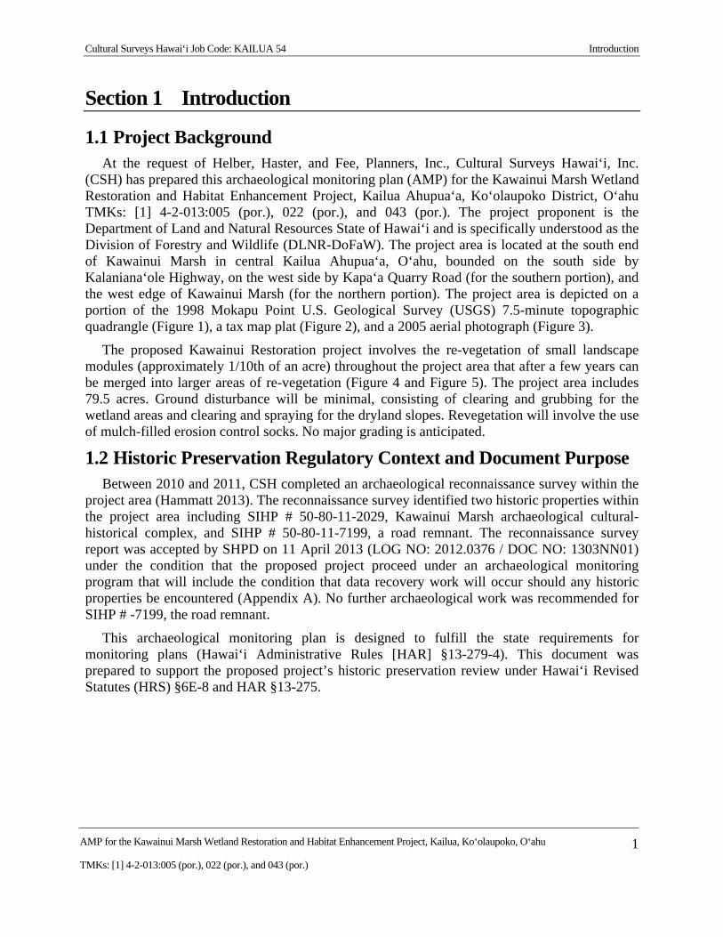
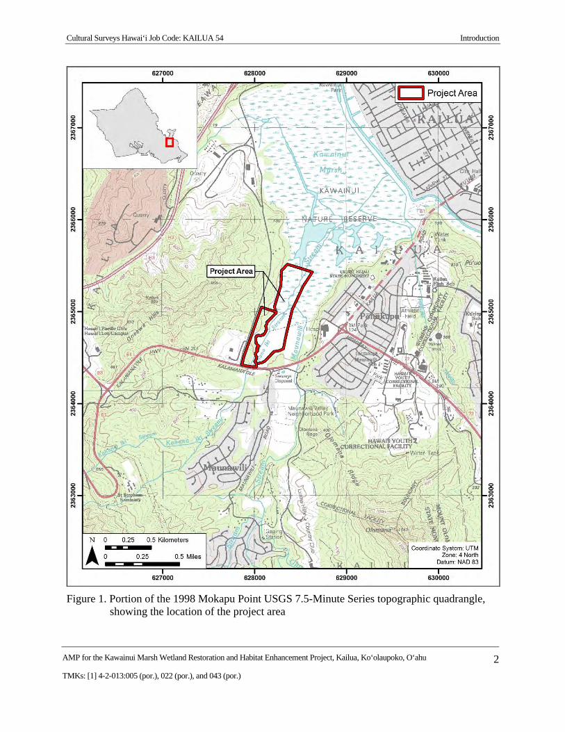
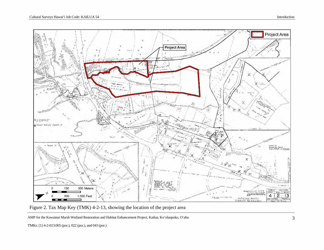
1.1 Project Background At the request of Helber, Haster, and Fee, Planners, Inc., Cultural Surveys Hawai‘i, Inc.
(CSH) has prepared this archaeological monitoring plan (AMP) for the Kawainui Marsh Wetland Restoration and Habitat Enhancement Project, Kailua Ahupua‘a, Ko‘olaupoko District, O‘ahu TMKs: [1] 4-2-013:005 (por.), 022 (por.), and 043 (por.). The project proponent is the Department of Land and Natural Resources State of Hawai‘i and is specifically understood as the Division of Forestry and Wildlife (DLNR-DoFaW). The project area is located at the south end of Kawainui Marsh in central Kailua Ahupua‘a, O‘ahu, bounded on the south side by Kalaniana‘ole Highway, on the west side by Kapa‘a Quarry Road (for the southern portion), and the west edge of Kawainui Marsh (for the northern portion). The project area is depicted on a portion of the 1998 Mokapu Point U.S. Geological Survey (USGS) 7.5-minute topographic quadrangle (Figure 1), a tax map plat (Figure 2), and a 2005 aerial photograph (Figure 3).
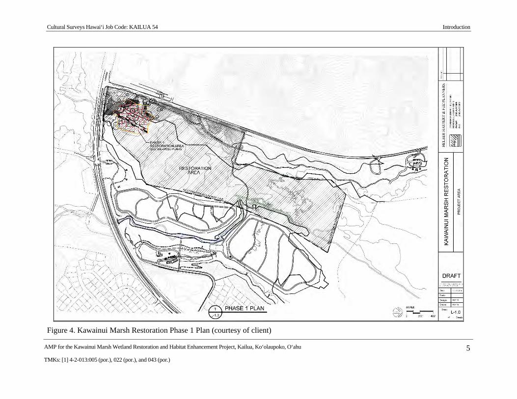
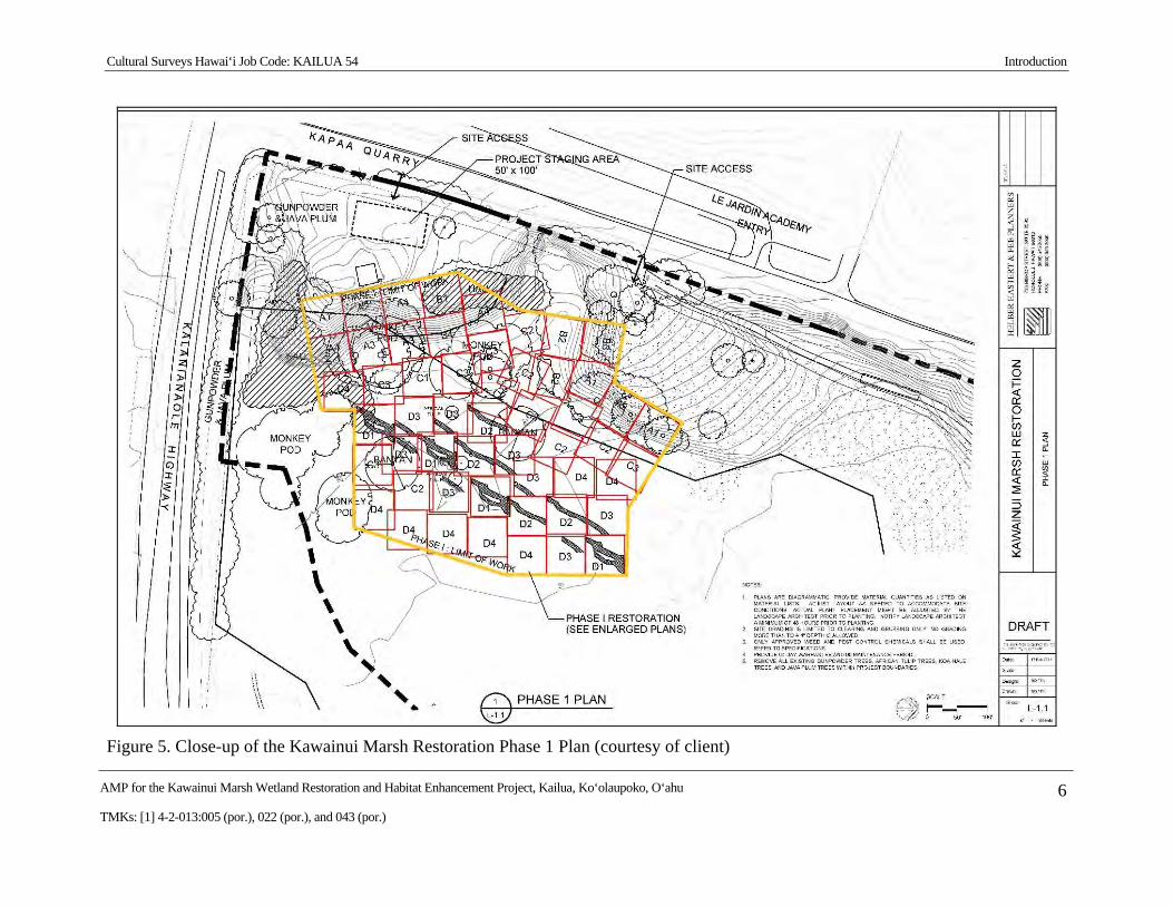
The proposed Kawainui Restoration project involves the re-vegetation of small landscape modules (approximately 1/10th of an acre) throughout the project area that after a few years can be merged into larger areas of re-vegetation (Figure 4 and Figure 5). The project area includes 79.5 acres. Ground disturbance will be minimal, consisting of clearing and grubbing for the wetland areas and clearing and spraying for the dryland slopes. Revegetation will involve the use of mulch-filled erosion control socks. No major grading is anticipated.
1.2 Historic Preservation Regulatory Context and Document Purpose Between 2010 and 2011, CSH completed an archaeological reconnaissance survey within the
project area (Hammatt 2013). The reconnaissance survey identified two historic properties within the project area including SIHP # 50-80-11-2029, Kawainui Marsh archaeological cultural-historical complex, and SIHP # 50-80-11-7199, a road remnant. The reconnaissance survey report was accepted by SHPD on 11 April 2013 (LOG NO: 2012.0376 / DOC NO: 1303NN01) under the condition that the proposed project proceed under an archaeological monitoring program that will include the condition that data recovery work will occur should any historic properties be encountered (Appendix A). No further archaeological work was recommended for SIHP # -7199, the road remnant.
This archaeological monitoring plan is designed to fulfill the state requirements for monitoring plans (Hawai‘i Administrative Rules [HAR] §13-279-4). This document was prepared to support the proposed project’s historic preservation review under Hawai‘i Revised Statutes (HRS) §6E-8 and HAR §13-275.
Cultural Surveys Hawai‘i Job Code: KAILUA 54 Introduction
AMP for the Kawainui Marsh Wetland Restoration and Habitat Enhancement Project, Kailua, Ko‘olaupoko, O‘ahu 2
TMKs: [1] 4-2-013:005 (por.), 022 (por.), and 043 (por.)
Figure 1. Portion of the 1998 Mokapu Point USGS 7.5-Minute Series topographic quadrangle, showing the location of the project area
Cultural Surveys Hawai‘i Job Code: KAILUA 54 Introduction
AMP for the Kawainui Marsh Wetland Restoration and Habitat Enhancement Project, Kailua, Ko‘olaupoko, O‘ahu 3
TMKs: [1] 4-2-013:005 (por.), 022 (por.), and 043 (por.)
Figure 2. Tax Map Key (TMK) 4-2-13, showing the location of the project area
Cultural Surveys Hawai‘i Job Code: KAILUA 54 Introduction
AMP for the Kawainui Marsh Wetland Restoration and Habitat Enhancement Project, Kailua, Ko‘olaupoko, O‘ahu 4
TMKs: [1] 4-2-013:005 (por.), 022 (por.), and 043 (por.)
Figure 3. 2005 USGS aerial photograph showing the location of the project area (USGS Orthoimagery 2005)
Cultural Surveys Hawai‘i Job Code: KAILUA 54 Introduction
AMP for the Kawainui Marsh Wetland Restoration and Habitat Enhancement Project, Kailua, Ko‘olaupoko, O‘ahu 5
TMKs: [1] 4-2-013:005 (por.), 022 (por.), and 043 (por.)
Figure 4. Kawainui Marsh Restoration Phase 1 Plan (courtesy of client)
Cultural Surveys Hawai‘i Job Code: KAILUA 54 Introduction
AMP for the Kawainui Marsh Wetland Restoration and Habitat Enhancement Project, Kailua, Ko‘olaupoko, O‘ahu 6
TMKs: [1] 4-2-013:005 (por.), 022 (por.), and 043 (por.)
Figure 5. Close-up of the Kawainui Marsh Restoration Phase 1 Plan (courtesy of client)
Cultural Surveys Hawai‘i Job Code: KAILUA 54 Introduction
AMP for the Kawainui Marsh Wetland Restoration and Habitat Enhancement Project, Kailua, Ko‘olaupoko, O‘ahu 7
TMKs: [1] 4-2-013:005 (por.), 022 (por.), and 043 (por.)
1.3 Environmental Setting 1.3.1 Natural Environment
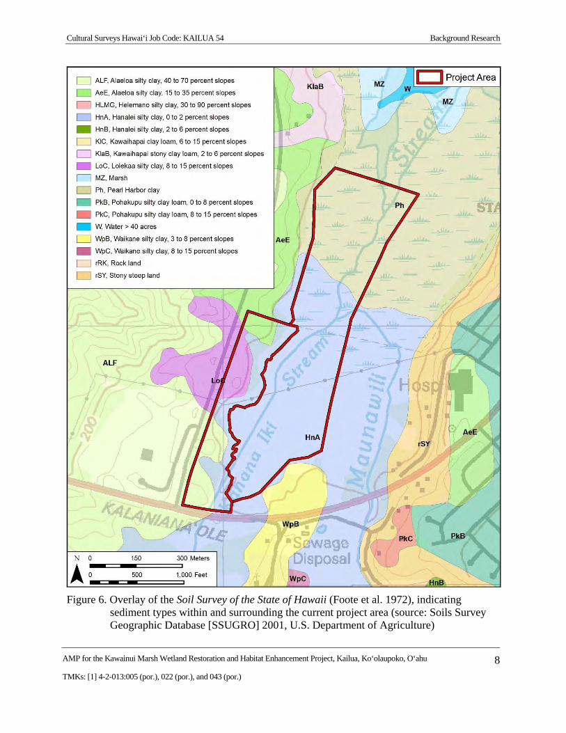
The project area is located within Kawainui Marsh, which is approximately 1.5 m above sea level. According to Foote et al. (1972), the project area includes four soil types, Pearl Harbor Clay, Hanalei Silty Clay, Lolekaa Silty Clay, and Alaeloa Silty Clay (Figure 6).
The northern portion of the project area overlies Pearl Harbor Clay (Ph). The Pearl Harbor soil series “consists of very poorly drained soils on nearly level coastal plains . . . developed in alluvium overlying organic material” (Foote et al. 1972:112). The southern portion of the project area overlies Hanalei Silty Clay, 0 to 2% slopes (HnA). The Hanalei series “consists of somewhat poorly drained to poorly drained soils on bottom lands . . . developed in alluvium derived from basic igneous rocks” (Foote et al. 1972:38). Portions of the project area along the western boundary overlay Lolekaa Silty Clay, 8 to 15% slopes (LoC) and Alaeloa Silty Clay, 15 to 35% slopes (AeE). The Lolekaa soil series “consists of well-drained soils on fans and terraces . . . developed in old, gravelly colluviums and alluvium” (Foote et al. 1972:83). The Alaeloa soil series “consists of well-drained soils on the uplands . . . developed in material weathered from basic igneous rock” (Foote et al. 1972:26).
Kahanaiki Stream, the western of the two major streams feeding Kawainui Marsh, (Maunawili Stream runs roughly parallel just 250 m to the east) basically bisects the project area. The present effects of siltation and eutrophication obscure to what extent these two streams actually channel water flow.
Marsh vegetation within the project area is dominated by California grass (Brachiaria mutica), which occurs on alluvial clays that are continuously damp and periodically flooded. On the western slopes are large monkey pod trees, extensive expanses of hau (Hibiscus tiliaceous), and a variety of other exotic shrubs.
1.3.2 Built Environment
The built environment surrounding the current project area includes Kalaniana‘ole Highway and associated improvements to the south and Kapa‘a Quarry Road and associated improvements to the west. The current project area remains undeveloped. Two gated, unimproved access roads provide entry to the project area from Kalaniana‘ole Highway and Kapa‘a Quarry Road.
Cultural Surveys Hawai‘i Job Code: KAILUA 54 Background Research
AMP for the Kawainui Marsh Wetland Restoration and Habitat Enhancement Project, Kailua, Ko‘olaupoko, O‘ahu 8
TMKs: [1] 4-2-013:005 (por.), 022 (por.), and 043 (por.)
Figure 6. Overlay of the Soil Survey of the State of Hawaii (Foote et al. 1972), indicating sediment types within and surrounding the current project area (source: Soils Survey Geographic Database [SSUGRO] 2001, U.S. Department of Agriculture)
Cultural Surveys Hawai‘i Job Code: KAILUA 54 Background Research
AMP for the Kawainui Marsh Wetland Restoration and Habitat Enhancement Project, Kailua, Ko‘olaupoko, O‘ahu 9
TMKs: [1] 4-2-013:005 (por.), 022 (por.), and 043 (por.)
Section 2 Background Research
2.1 Traditional and Historical Background The history of Kailua region of O‘ahu has been documented in a number of studies including,
but not limited to, Creed and Chiogioji’s (1991) Facets of Maunawili Valley and Kailua Ahupua‘a History, Hall’s (1997) The History of Kailua, the Kailua Historical Society’s (2009) Kailua in the Wisps of the Malanai Breeze, and Kelly and Nakamura’s (1981) Historical Study of Kawai Nui Marsh Area, Island of O‘ahu. All of these studies detail the legendary history and oral traditions, the legendary rulers and personalities, the early historic accounts, land ownership, and utilization changes during and following the Māhele, and the changes in land use from the traditional to modern period. Included in this section, under the discussion of the Māhele land divisions of the mid-nineteenth century, is a detailed discussion of the Land Commission Awards claimed and awarded within the current Kawainui Marsh Wetland Restoration and Habitat Enhancement Project area.
Kailua Ahupua‘a is the largest valley on the windward side of O‘ahu, and the largest ahupua‘a of the Ko‘olaupoko District (approximately 15 km by 11 km). Flanked by the ahupua‘a of Waimānalo on the southeast, Kāne‘ohe on the northwest, and Honolulu to the south, the ahupua‘a of Kailua is shaped like a rectangle. From the Ko‘olau ridge line it extends down two descending ridge lines which provide the natural boundaries for the sides of the ahupua‘a. The fourth side of the rectangle is the reef line of Kailua Bay.
The natural environment includes the sand accretion barrier upon which Kailua Town stands, the mountainous upland terrain and alluvial valley of Maunawili, the largest freshwater marsh in Hawai‘i (Kawainui Marsh), another inland pond (Ka‘elepulu), approximately 18 permanent and intermittent streams, a freestanding mountain halfway between the shore and the Ko‘olau (Olomana–1,643 ft), several low ridge lines, and the off-shore Mokulua Islands, Mokole‘a Rock, and Popoia Island. It comprises 11,885 acres of land according to the Boundary Commission Review of the mid-nineteenth century, but in fact extends beyond the shore approximately a mile out to sea, to the reef.
During the estimated 1,000 to 1,500 years since initial Polynesian settlement, the sand barrier that forms the shore at Kailua Bay has provided a desirable location for residences with a sunny, dry beach area. The well-watered interior lands, including the two marsh/pond areas of Ka‘elepulu and Kawainui and the many springs and streams of Maunawili, provided bountiful agricultural and resource gathering areas. During the fifteenth and sixteenth centuries, Kailua, O‘ahu was the center of a large royal complex with sample playgrounds for sports and physical training, and recreation (Sterling and Summers 1978:231-232). Supporting this large complex was a most bountiful garden hinterland where fish, fowl, and vegetables were plentiful (Sterling and Summers 1978:227-228).
2.1.1 Mythological and Traditional Accounts
Kailua is said to have been one of the places where, following their arrival on O‘ahu from Kahiki, the menehune were assigned to live. These legendary workers are credited with the construction of numerous fishponds and religious structures. Fornander (1917-1918:23) points
Cultural Surveys Hawai‘i Job Code: KAILUA 54 Background Research
AMP for the Kawainui Marsh Wetland Restoration and Habitat Enhancement Project, Kailua, Ko‘olaupoko, O‘ahu 10
TMKs: [1] 4-2-013:005 (por.), 022 (por.), and 043 (por.)
out that the term menehune in Tahitian had become the name for the lowest laboring class of people, suggesting a Tahitian origin for the term for the legendary workers.
Traditional history describes Kailua as the residence of many prominent O‘ahu ruling chiefs. There is ‘Olopana, “who with his brother Kahiki‘ula came to O‘ahu from Kahiki . . . He is said to have established several heiau in Kāne‘ohe and Kailua, including Pahukini and Holomakani in the Kawainui area” (Kelly and Nakamura 1981:3). One of the earliest great chiefs to reside in Kailua was the sixteenth-century ruler Kakuhihewa, who built himself a great house at ‘Ālele in Kailua (Kelly and Nakamura 1981:5). At approximately the same time, another prominent chief, Kuali‘i, born at Kalapawai, Kailua, and raised in Kualoa and Kailua, had his navel-cutting ceremony at the heiau of Alāla (present-day Lanikai Point); and, after heroically succeeding in many battles, became the high chief of all O‘ahu (Kelly and Nakamura 1981:6). In early historic times, the conquering chief Kahekili, followed by Kamehameha I, resided in Kailua for a time (Kelly and Nakamura 1981:6-7).
There are legendary accounts of the prominent Mount Olomana, which is named after a great mythological giant and/or chief (Kelly and Nakamura 1981:1). Tradition also says Kawainui was inhabited by a mo‘o called Hauwahine, whose name literally means “female ruler.” Her residency at Kawainui follows Haumea’s, the earth-mother goddess whose name literally means “red ruler.” She ensured that all the people of the ahupua‘a shared in the pond’s wealth but she punished those who were greedy (Beckwith 1970:126).
Oral history notes that the stones overlooking Kawainui on Pu‘u o ‘Ehu are sacred to Hauwahine and her companion (Paki 1976). This interpretation is connected to the ancient Hawaiian notion that the channel/canal beneath Pu‘u o ‘Ehu (which is adjacent to the southern portion of the study area) connects Kawainui and Ka‘elepulu and was considered to be the coital connection between the two fishponds, giving the area great mana (spiritual or divine power). Kawainui Marsh was considered male, and Ka‘elepulu Pond, female. They mated at Kawailoa, according to a Hawaiian tradition (Paki 1976).
Mele, or chants, about Kailua frequently mention the two fishponds, which were famous for their ‘ama‘ama (mullet, Mugil cephalus) and awa (milkfish, Chanos chanos). They also praise the taro gardens of the area (see Beckwith 1970 and Drigot 1982). A few of these chants and legends are those of Hi‘iaka, Kahinihini‘ula, the Mākālei Tree, and Ka‘ulu.
Situated between the sunny beach area and uplands watered by frequent showers, other resources were readily available in Kailua. As the center of the caldera of the ancient Ko‘olau Volcano, a basalt quarry (the present Ameron Quarry is built upon the site of the pre-Contact quarry) provided raw material for lithic tools (MacDonald and Abbott 1974:363). Kailua was a residential district surrounded by ahupua‘a that were also highly cultivated and capable of providing ample resources for a large resident and visiting population. Kailua apparently also was a pu‘uhonua (place of refuge) before Kamehameha I conquered the island of O‘ahu. After this time, the ancient pu‘uhonua were abolished.
2.1.1.1 Mount Olomana
“Olo,” meaning “hill,” and “mana,” meaning “forked divided, or branched,” is a peak that rises 1,643 ft from the valley floor (Creed and Chiogioji 1991:33). The remains of a long-extinct volcano, Olomana has two neighboring peaks, Pāku‘i and Ahiki. Many legends are associated
Cultural Surveys Hawai‘i Job Code: KAILUA 54 Background Research
AMP for the Kawainui Marsh Wetland Restoration and Habitat Enhancement Project, Kailua, Ko‘olaupoko, O‘ahu 11
TMKs: [1] 4-2-013:005 (por.), 022 (por.), and 043 (por.)
with Olomana, which is named after a great mythological giant and is also the name for a renowned O‘ahu chief (Kelly and Nakamura 1981:1). One legend relates that Haumea installed Olomana as the chief of the district. But Olomana’s pride and arrogance cause Palila, a “warrior of the gods” from Kaua‘i to punish Olomana (Creed and Chiogioji 1991:6). Palila breaks Olomana in two and throws one portion to the sea and the other becomes the Mount Olomana we know today (Kelly and Nakamura 1981:1). Another legend describes the giant Olomana jumping from Kaua‘i to the O‘ahu peak that bears his name. Traditions related to early creation stories also mention Olomana (Creed and Chiogioji 1991:33).
The middle of the three peaks of Mount Olomana, Pāku‘i (literally, “attached”), is named after the legendary keeper of the Kawainui and Ka‘elepulu fishponds who was a fast runner (Pukui et al. 1974:176). Ahiki is the closest peak to Waimānalo, and is named after the konohiki of Ka‘elepulu and Kawainui ponds (Pukui et al. 1974:5).
2.1.1.2 Kawainui Marsh
Kawainui Marsh was traditionally known as Kawai Nui Loko, or the big freshwater pond. The locale’s name has two spellings in the literature, Kawai Nui, and as one word, Kawainui. Currently, Kawainui appears to be the more common spelling and will be used in this document unless it appears in a citation or title.
The marsh is a “wahi pana,” a celebrated, noted, and legendary place in Hawaiian traditions. The legends of Kawelo, Kahalaopuna, Keaomelemele, the menehune (mythical “little people” who built major structures in old times) all refer to Kawainui, as does the history of the ruling chiefs Kūali‘i and Olopana. The marsh was the home of the mo‘o (supernatural water spirit) Hauwahine and of the wish-fulfilling tree, Mākālei. The demi-goddess Hi‘iaka and her companion Wahine-‘ōma‘o visited, and Kawainui’s fame is related in numerous chants (Drigot 1982:84-96 presents a good summary). Historically, a portion of Kawainui Marsh was a 450-acre fishpond that was cleared of encroaching vegetation by the communal efforts of the ahupua‘a residents. Kawainui was recognized for the abundance of resources that the area supplied to the Hawaiian people, including avian, earth, fish, and plant resources.
2.1.1.2.1 The Mākālei The Mākālei, or Fish-Attracting Tree, was a mythological tree or stick that could summon
fish from Kawainui. Reportedly located near the present day Hāmākua Bridge, it was described as a never-failing source of a plentiful supply of food (Beckwith 1970:279-280, Pukui and Elbert 1986:382) and it speaks of the ample productivity of the Kailua region. Haumea, the earth mother goddess of fertility and childbirth, is depicted in Hawaiian folklore as the one who brings the Mākālei tree to Kawainui, thereby establishing the fertile waters of the marsh (Kelly and Nakamura 1981:4-5, Creed and Chiogioji 1991:6). The removal of the tree by Haumea to punish the ali‘i who forgot to distribute Kawainui’s fish to a small, red-headed boy named Kahinihiniula and his grandmother Neula is a strong reminder of the chiefs’ “responsibility of stewardship to the planters on whom they depended for food and power” (Creed and Chiogioji 1991:6). Once the ali‘i realized their shortcoming, Haumea returned the Mākālei tree to a hidden place and the fish returned to Kawainui.
Cultural Surveys Hawai‘i Job Code: KAILUA 54 Background Research
AMP for the Kawainui Marsh Wetland Restoration and Habitat Enhancement Project, Kailua, Ko‘olaupoko, O‘ahu 12
TMKs: [1] 4-2-013:005 (por.), 022 (por.), and 043 (por.)
2.1.1.2.2 Hauwahine, the Mo‘o of Kawainui Tradition also says Kawainui was inhabited by a guardian spirit, or mo‘o, called Hauwahine,
whose name literally means “female ruler.” Her residency at Kawainui follows Haumea’s, the earth-mother goddess whose name literally means “red ruler.” As previously mentioned, she ensured that all the people of the ahupua‘a shared in the pond’s wealth and those who were greedy were punished (Beckwith 1970:126). According to legend, Hauwahine had a companion, a second mo‘o, who reportedly lived at the hala grove near the Ka‘elepulu stream. If one sees yellow grass and yellow rush in the stream, it is a sign of the presence of the two mo‘o women (Kelly and Nakamura 1981:3, citing an anonymous source).
2.1.1.2.3 Avian Resources One folk saying paints a picture of the large number of birds living in the marsh:
Wawā ka menehune i The shouts of the menehune on Pu‘ukapele ma Kaua‘i, puoho Pu‘ukapele on Kaua‘i startled ka manu o ka loko o Kawainui the birds of Kawai Nui Pond ma O‘ahu. on O‘ahu. [Pukui 1983:320]
Visitors to the area also wrote about the bountiful resources in the marsh area. In 1880, George Bowser noted the following:
Wild duck and the famous Hawaiian goose are also to be found here in abundance. During the day I have fallen in with any quantity of plover. A good shot might have bagged his fifty brace in a very short time. These birds are very plentiful all over this part of the country . . . (Kelly and Nakamura 1981:60)
An article in a Hawaiian language newspaper in 1911 stated that “The necks of the birds appeared on the pond of Kawainui among the rushes . . . ” (Ke Au Hou 1911). Birds documented living at Kawainui include various geese and ducks, or koloa, such as Northern Pintail (Anas acuta), Northern Shoveler (Anas clypeata), Mallard (Anas platyrhynchos), Canada Goose (Branta canadensis), Emperor goose (Chen canagica), Ring-necked Duck (Aythya collaris), Lesser Scaup (Aythya affinis), Green-winged Teal (Anas crecca), American Widgeon (Anas americana), and Redhead (Aythya americana) (Conant 1981; Drigot 1982; Engilis 1988; Shallengerger 1977; U.S. Fish and Wildlife Service 1991).
Migratory shorebirds that flock to Kawainui Marsh include the Lesser Golden Plover (Pluvialia dominica), Ruddy Turnstone or ‘Akekeke (Arenaria interpres), Sanderling or Hunakai (Calidris alba), and Wandering Tattler (Heteroscelus incanus) (Conant 1981; Drigot 1982; Engilis 1988; Shallengerger 1977; U.S. Fish and Wildlife Service 1991). Other species include the indigenous Black-crowned Night Heron, or ‘Auku‘u (Nycticorax nycticorax hoactli); and four endemic, federally-listed endangered waterbird species, the Hawaiian Coot, or ‘Alae Ke‘oke‘o (Fulica americana alai); Hawai‘i Gallinule (a.k.a. the Hawaiian Common Moorhen), or ‘Alae ‘ula (Gallinula chloropus sandvicensis); Hawaiian Duck, or Koloa maoli (Anas wyvilliana); and Hawaiian Stilt, or Ae‘o (Kukulu ae‘o) (Himantopus mexicanus knudseni) (Bruner 2000; Conant 1981; Drigot 1982; Engilis 1988; Shallengerger 1977; U.S. Fish and Wildlife Service 1991).
David Malo discussed the role of birds in Hawaiian culture, especially regarding the ‘Alae (Fulica americana alai and Galinula chloropus sandvicensis):
Cultural Surveys Hawai‘i Job Code: KAILUA 54 Background Research
AMP for the Kawainui Marsh Wetland Restoration and Habitat Enhancement Project, Kailua, Ko‘olaupoko, O‘ahu 13
TMKs: [1] 4-2-013:005 (por.), 022 (por.), and 043 (por.)
. . . ua mana‘o ia keia manu, he akua, ua nui ka po‘e ho‘omana i keia manu, ua like kona nui me kekahi moa wahine, he manu ‘ono no ke ‘ai ia i ke alualu a me ka pehi ka mea e loaa [a]i. [Malo 2006]
This bird is thought to be a god and there are many people who worship this bird. Its size is like a hen. It is delicious to eat and it is chased after using stones (pehi) to catch it. [(Malo 2006]
Malo also names the Koloa (Anas wyvilliana and other ducks) and the Lesser Golden Plover (Pluvialia dominica) as “he manu ono,” delicious birds. The Kukulu ae‘o (Himantopus mexicanus knudseni) is reported as a kind of edible bird (he manu ano ke ‘ai ia) as is the ‘Auku‘u (Nycticorax nycticorax hoactli) (Chun 1987:22, 164). These water birds were taken by pelting them with stones.
Several waterfowl species were widely hunted for food from traditional Hawaiian times into the mid-twentieth century. The Hawaiian Coot and Hawaiian Duck were legal game birds until 1939 (a bag limit of 25 birds a day was set), and the Hawaiian Gallinule and Hawaiian Stilt were legally hunted until 1941 (Drigot 1982:142-148). Many of these waterfowl species are listed as endangered species and protected by federal and state laws generally acknowledged as overriding native customary practices (for example, as in the case of sea turtles).
The only other bird species present that are known to have been worshiped other than the ‘Alae was the Kōlea (Valeri 1985:27), although it is highly possible that certain ‘Auku‘u would have been an ‘aumakua (guardian ancestral spirit) species. Several of the bird species in Kawainui, including the ‘Akekeke, ‘Alae Ke‘oke‘o, ‘Alae ‘Ula, ‘Auku‘u, Kolea, and the transiting Great Frigate bird or ‘Iwa (Fregata minor palmerstoni), have various mythological associations (see Drigot 1982:141 ff.).
2.1.1.2.4 Earth Resources Sterling and Summers (1978:229) described the traditional Hawaiian adze quarry “on the
[Kapa‘a] slopes below (north) of Pahukini heiau” that was “investigated by Dr. Emory and his class in 1951.” The quarry is relatively close to Kawainui and the heiau appears to be associated with the marsh. Sterling and Summers (1978:229) note that in 1953, the H.C.&D. quarry encroached on the quarry site, and by 1975, it was destroyed.
One of the more famous traditional Hawaiian associations with Kawainui is the “edible earth” (Lepo ‘ai ia). Pukui (1983:83) provides the following poetical saying:
He lepo ka ‘ai a O‘ahu, a Earth is the food of O‘ahu, and mā‘ona no i ka lepo it is satisfied with the earth
Pukui explains the proverb, stating:
Said in derision of O‘ahu, which was said to be an earth-eating land. In olden times, an edible mud like gelatine was said to fill Kawai Nui Pond. The mud which was brought hither from Kahiki in ancient days, was once served to the warriors and servants of Kamehameha as a replacement for poi. [Pukui 1983:83-84]
In addition to Mary Pukui’s account, Sterling and Summers (1978:231-232) provide the following accounts of the edible mud:
Cultural Surveys Hawai‘i Job Code: KAILUA 54 Background Research
AMP for the Kawainui Marsh Wetland Restoration and Habitat Enhancement Project, Kailua, Ko‘olaupoko, O‘ahu 14
TMKs: [1] 4-2-013:005 (por.), 022 (por.), and 043 (por.)
When there was a shortage of taro in Kailua, during Kamehameha’s stay there with his men, the men of Kailua went to the pond of Kawainui to get the edible mud of Kawainui. It was a mud brought from Kahiki by Kaulu-a-kalana and put in the pond of Kawainui. The warriors and servants of Kamehameha ate the mud which had been put in the calabashes. [History of Kamehameha, Ka Na‘i Aupuni 4 September 1906 in Sterling and Summers 1978:231-232]
The additional information is provided:
The ‘Lepo ‘ai ia,’ or edible mud, was found only in Kawainui Pond at Kailua, O‘ahu. It was thick and jelly-like, like haupia pudding. A strict kapu was imposed when one dived to get it. No one was allowed to utter a word while the diver was in the pond getting it. If a word was spoken, ordinary mud rose up around the diver and covered him so that he died. There was no escape. [Note from Lahilahi Webb in Sterling and Summers 1978:232]
There is a tradition among archaeologists that a certain archaeologist from the mainland consumed a good serving of the famous “Lepo ‘ai ia.” He soon fell quite sick. Given the presence of potentially lethal leptospirosis in the Kawainui drainage, mud consumption cannot be recommended and is not believed to be ongoing.
2.1.1.2.5 Fish Resources A portion of Kawainui was historically a 450-acre fishpond known as Kawainui Loko, a
partially brackish inland pond (loko wai) famous for harboring fat fish (Kamakau 1875). It had “the finest fat mullet on this side of the island . . . The Awa fish were so tame that they were easily caught” (Alona 1939:1314-1315). While it is believed the pond was the property of the ali‘i (McAllister 1933:186), Keko‘owai gives an account of communal cleaning of the pond in which the people harvested some fish for their own use.
This being communal work, the konohiki (land agent) commanded the men, women and children of Maunawili, Kailua and Waimānalo to come to Kawai Nui. The people went into the pond, and with their hands broke the limu (algae) loose, piling it up, twisting it under as it was gathered. After a quantity of limu had been piled and twisted under, the workers formed it into a ring. ‘Then the limu that was broken off was pressed (pili) down like a dish and all the fish that were caught in this limu dish were for the limu breakers.’ The workers put these fish into lauhala bags which were tied behind them, for the fish in the ‘limu dish’ were no longer the property of the konohiki. Breaking of the limu was continued until the pond was clean and ‘the food of the fish clean,’ which for Kawai Nui, required three days. [Ka Nupepa Kuokoa, 6 January 1922 in Summers 1964:22]
While the majority of fish species reported from Kawainui are exotic, native species of the Kawainui drainage include the endemic goby or O‘opu nākea (Awaous stamineus), the indigenous goby ‘O‘opu naniha (Stenogobius genivittatus), the endemic eleotrid with various Hawaiian names, ‘O‘opu ‘akupa, ‘Okuhe, ‘Apoha, Kuhe, ‘Oau (Eleotris sandwicensis), the endemic flagtail (Kuhlia sandvicensis), the indigenous mullet or ‘Ama‘ama (Mughil cephalis), Milkfish or Awa (Chanos chanos), and occasionally a variety of other common inshore species including jacks, barracuda, and lizard fish (Drigot 1982:177; U.S. Fish and Wildlife Service
Cultural Surveys Hawai‘i Job Code: KAILUA 54 Background Research
AMP for the Kawainui Marsh Wetland Restoration and Habitat Enhancement Project, Kailua, Ko‘olaupoko, O‘ahu 15
TMKs: [1] 4-2-013:005 (por.), 022 (por.), and 043 (por.)
1991). Mullet, Awa and the ‘O‘opu were the most famous fish of the pond (Alona 1939; Saturday Press 1883). The ‘O‘opu were proverbial as in the saying:
He ‘o‘opu ku‘ia, ka i‘a hila A bashful ‘o‘opu, the shy fish o Kawai Nui of Kawai Nui
Pukui (1983:94) explains that this folk saying was applied to describe a bashful person. Another traditional account of the ‘O‘opu catching at Kawainui was published in 1883:
The ‘O‘opu kuia was a large fat mud fish, caught by many people joining hands and dancing in its [Kawainui’s] waters to stir up mud, when the fish would run their heads up against the people, and so were caught. The fishes would cluster very thickly against particular individuals while leaving many others untouched, when, of course, he or she, would make a good haul and fill up his calabashes rapidly. This gave rise to the common saying of olden times, ‘he ‘ili ona ia’--‘attractive skin.’ [Saturday Press 1883]
In a somewhat similar vein, Alona (1939) relates that the Awa fish of Kawainui “did not like persons with strong smelling skins (‘ili awa) and kept away from them.”
2.1.1.2.6 Plant Resources Vegetation composition within Kawainui Marsh has been significantly impacted by human
activities with the result that the overwhelming majority of the vegetation is exotic. Some vegetation studies report no native plants or Polynesian introductions at all (M&E Pacific, Inc. 1990:3-21). Dominant plants include exotic species such as California bulrush (Schoenoplectus californicus), saw-grass (Thelypteris interrupta), common cat-tail (Typha latifolia), California grass (Brachiaria mutica), arrowhead (Sagittaria latifolia), Wandering Jew, or Honohono grass (Commelina diffusa), water hyacinth (Eichhornia crassipes), and water lettuce (Pistia stratiotes) (Drigot 1982; U.S. Fish and Wildlife Service 1991). The upper slopes are wooded with haole koa (Leucaena leucocephala), guava (Psidium guajava), Chinese banyan (Ficus microcarpa), Christmasberry (Schinus terebinthifolius), Java plum (Syzygium cumini), octopus tree (Schefflera actinophylla), African tulip tree (Spathodea campanulata), albizia (Falcataria moluccana), and monkey pod (Samanea saman) (M&E Pacific, Inc. 1990:3-21).
However, as Beatrice Krauss pointed out in 1980, the ethnobotany of the marsh is not well-documented as the common approach “to the study of the flora surrounding Kawainui Marsh has been one which appears almost totally taxonomic and ecological” (Drigot 1982:99). The only plants that are indigenous include Hau (Hibiscus tiliaceus), ‘Anapanapa (Colubrina asiatica) and Kāmole (primrose willow, Ludwigia octivalvis). Hau was used for quite a variety of traditional purposes such as fiber, fish net floats, fire making, tool handles, outriggers, fireworks, and religious ceremonies. Hau is rather ubiquitous in Ko‘olau, O‘ahu. No specific cultural uses of ‘Anapanapa or Kāmole are known. Such Polynesian introductions as Noni (Morinda citrifolia), ‘Ulu (Artocarpus communis), Mai‘a (Musa paradisiaca), and Kalo (Colocasia esculenta) are known on the perimeter of the marsh. Some plants that have been associated with many Kailua and Kawainui Marsh legends are still likely to be present, including ‘awa, ‘ōhi‘a, pūhala, ‘uki, ‘aka‘akai, ‘ilima, loulu, popolo, kukui, and various limu (seaweeds) (Drigot 1982:104). Any ongoing Hawaiian gathering practices are likely to be focused on these Polynesian cultigens and later introductions such as mango (Mangifera indica).
Cultural Surveys Hawai‘i Job Code: KAILUA 54 Background Research
AMP for the Kawainui Marsh Wetland Restoration and Habitat Enhancement Project, Kailua, Ko‘olaupoko, O‘ahu 16
TMKs: [1] 4-2-013:005 (por.), 022 (por.), and 043 (por.)
2.1.1.2.7 Heiau Three heiau: Ulupō, Holomakani and Pahukini, are within close proximity of Kawainui
Marsh. Four other heiau, Halaualolo, Kawailoa, Kukapoki, and Pu‘uwaniania, are associated with streams and springs that feed the marsh. The location of seven heiau within the vicinity of the marsh indicates its traditional significance (Brennan 2007a).
Ulupō Heiau measures 140 by 180 ft and its walls are up to 30 ft in height. Its original construction is attributed to the menehune, which indicates its antiquity. According to legend, some of the stones were transported from Kualoa. It is likely the terraced platform was originally a mapele, or agricultural heiau, based on its location adjacent to the marsh. Over time, however, the heiau is believed to have been converted into a luakini or a large heiau used for human sacrifice and associated with war. The size of the structure indicates an ali‘i had the power to order enough people to construct the heiau (State of Hawai‘i 1997).
Handy and Handy (1972) add,
Kailua must formerly have been very rich agriculturally, having one of the most extensive continuous terrace areas on Oahu, extending inland one and a half miles from the margin of Kawainui Swamp. Terraces extended up into the various valleys that run back into the Ko‘olau range. There were some terraces watered by springs and a small stream from Olomana mountain along the western slope of the ridge that lies southeast of Kawainui Swamp, and another system of terraces was east of the seaward end of the ridge, watered by the stream which joins Kawainui and Ka‘elepulu Ponds. There were also terraces north of the Kawainui Pond, and several terrace areas flanked Ka‘elepulu Pond at the base of the ridge to the eastward. Much former taro land reverted to swamp when abandoned; this has since been drained. [Handy and Handy 1972:457]
2.1.2 Early Historic Period
Historic accounts of Kailua before the 1850s are rare. One of the only accounts that could be located is that of Levi Chamberlain, a missionary who made a circuit around O‘ahu to inspect the mission schools in 1828. This account is particularly important because Chamberlain travels through and describes the landscape in the immediate vicinity of the current Kawainui Marsh Wetland Restoration and Habitat Enhancement Project area. Chamberlain describes his progress from the settlement at Kailua through the low hills, today called the Kalaheo hills and the location of Kalāheo High School, that separate Kailua from Kāne‘ohe.
Directing our course towards Kāne‘ohe, the next district, we were obliged to pass over a tract of low land mostly overflowed with water by the late rains. Here I was obliged to wade, as the distance was too great to admit of my being carried on the shoulders of my attendants, as was generally the case in passing a small stream of water. After emerging from the flat, our path was not improved, for we had now to walk through mud instead of water–we walked some distance along the steep hill, and at length by a winding path ascended to the top of it. We sat down to rest for a few minutes, and I found myself upon the summit of a ridge extending from the mountains in a right line to the sea and dividing the low lands of Kailua from those of Kaneohe. [Chamberlain Ms.:664 in Kelly and Nakamura 1981:7]
Cultural Surveys Hawai‘i Job Code: KAILUA 54 Background Research
AMP for the Kawainui Marsh Wetland Restoration and Habitat Enhancement Project, Kailua, Ko‘olaupoko, O‘ahu 17
TMKs: [1] 4-2-013:005 (por.), 022 (por.), and 043 (por.)
It is clear from this account that this west-northwest portion of Kailua, in the vicinity of the project area, was low lying and prone to flooding. As we shall see in later discussions, this does not appear to change with the passage of time.
The drastic depopulation of the Hawaiian Islands following the introduction of Western disease has been documented in a number of sources (Bingham 1847; Bushnell 1993; Stannard 1989). According to one estimate the population of Hawaiians and part-Hawaiians fell from approximately 300,000 in 1778 to 82,593 by 1850 (Schmitt 1968:43). Population counts from the 1830s place the population of Kailua at approximately 760 individuals (Schmitt 1973:19). This low population figure is incongruous with the productivity of the region, but well in keeping with population decline estimates due to western disease. Westerners passing through Ko‘olaupoko in the mid-1840s made note of the cold and flu symptoms among the Native Hawaiians and that much formerly productive land appeared abandoned (Wyllie 1848:20).
2.1.3 Mid- to Late 1800s
2.1.3.1 Māhele Records
Māhele records are an important resource for determining land use during the first half of the nineteenth century. In the division of lands among Kamehameha III and his people between 1848 and 1853, approximately 250 Land Commission Awards (LCAs) were claimed before the Board of Commissioners to Quiet Land Titles (Land Commission) in Kailua.
Many Kailua claimants list kings, queens, kuhina nui or governors to provide a time frame for when they received their land. The earliest such reference appears to be Kaloli, the wife of Kalani‘ōpu‘u who lived from 1752 to 1782 (Kuykendall 1980:30-32), followed by Kamehameha I, Mō‘ī or king and conqueror of O‘ahu in 1795 (Kuykendall 1980:87); Liholiho, King Kamehameha II in the 1820s; Kaomi, the Tahitian companion of Kamehameha III who died in 1833 (Kuykendall 1980:135); Boki, governor in the 1820s and his wife Liliha, kuhina nui—after 1829 and during the 1830s; Kīna‘u, Queen from 1832-1839; Ka‘ahumanu, Queen and kuhina nui in the 1820s; and Kekū‘anao‘a, the governor of O‘ahu in the 1830s and 1840s (Kuykendall 1980:286); Pākī, a high chief during the same period (Kuykendall 1980:285); and Kamehameha III during the early 1840s. Some claimants give specific dates and these range from 1828-1848. Thus, the people established in Kailua by 1848-1853 only ascribe their roots to the land from the period of the 60-70 years before the Land Commission Awards. While some claimant’s lands may have been in their family for longer periods, it would not have been politically correct in the land commission claims for land offered to them by Kamehameha III to refer to rulers prior to the Kamehameha dynasty.
It appears that Kailua, Kāne‘ohe, and Waimānalo were considered choice locations at the time of the Māhele as these ahupua‘a were awarded to the Crown, the royal family, and then to important ali‘i (particularly warrior chiefs for Kamehameha I). The entire ahupua‘a of Kailua was awarded to Queen Hakaleleponi Kapakuhaili Kalama (ca. 1820-1870), wife of Kamehameha III. An 1881 Hawaiian government survey map underscores the primary political fact of ownership of most of the marsh by Queen Kalama under LCA 4452 (Figure 7). The lands of Kūkanono are indicated to extend far out into the marsh, perhaps as far west as Maunawili Stream.
Cultural Surveys Hawai‘i Job Code: KAILUA 54 Background Research
AMP for the Kawainui Marsh Wetland Restoration and Habitat Enhancement Project, Kailua, Ko‘olaupoko, O‘ahu 18
TMKs: [1] 4-2-013:005 (por.), 022 (por.), and 043 (por.)
Figure 7. 1881 Oahu Island Hawaiian Government survey map showing the location of the current project area (Covington 1881)
Cultural Surveys Hawai‘i Job Code: KAILUA 54 Background Research
AMP for the Kawainui Marsh Wetland Restoration and Habitat Enhancement Project, Kailua, Ko‘olaupoko, O‘ahu 19
TMKs: [1] 4-2-013:005 (por.), 022 (por.), and 043 (por.)
The Land Commission Award (LCA) records for Kailua document a thriving cultural landscape of garden areas clustered along its approximately 18 permanent and intermittent streams. The Maunawili/Kahana‘iki Stream delta is a large, marshy low-lying area with no more than a 6% slope, with fertile soils along stream beds with many taro lo‘i. Kapa‘a Valley is narrow but also had many gardens along its stream. Other fertile areas were cultivated on the mauka side of Ka‘elepulu Pond (modern fill now surrounds most of the former pond) going toward Waimānalo. Several fertile areas were cultivated within the present-day MidPac Country Club. The two great lagoonal fishponds joined below the lookout point of Pu‘u o ‘Ehu and agricultural lands were maintained nearby drawing upon the wealth of these pond resources. A very narrow fertile area sits on the Pōhākupu upland about the location of Kailua High School. Most of the LCAs documented in the Native Register, Foreign Testimony and Native Testimony were in these areas close to ample surface water.
As reflected by Land Commission documentation, the settlement pattern within the Kawainui Marsh Wetland Restoration and Habitat Enhancement Project area during the mid-1800s was dominated by irrigated agriculture. Agricultural lands included numerous spring and stream watered pond fields (lo‘i). Dryland agriculture would have dotted the hill slopes above the marsh. Crops included traditional Hawaiian economic plants as well as Western introduced economic plants such as fruit trees. House lots would have been dispersed on the higher grounds surrounding the marsh. Māhele records indicate differing periods of occupation of the land claimants. Some appear to be long-time local residents. Others evidently received their land from the Kamehameha dynasty shortly before the time of the claim.
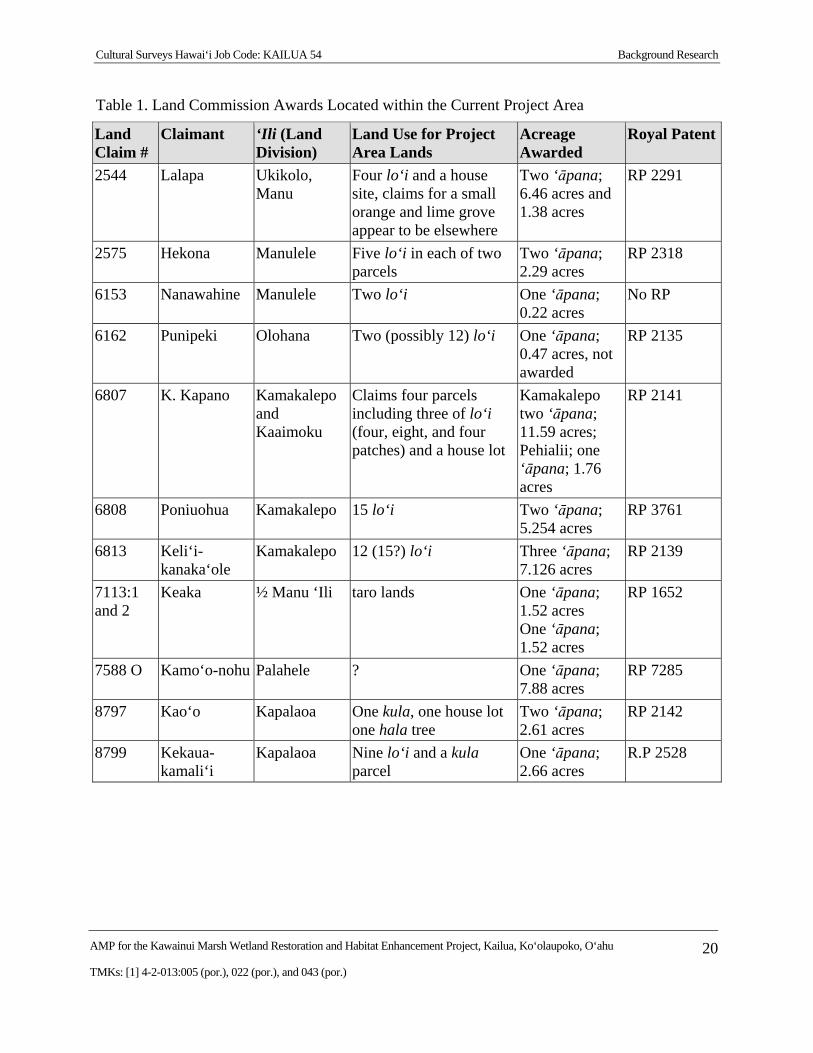
Table 1 lists the LCAs for the Kawainui Marsh Wetland Restoration and Habitat Enhancement Project area. The table was compiled using LCA information available through the Waihona ‘Aina online database (Waihona ‘Aina 2000) and from the Hawai‘i State Archives. For complete LCA and Royal Patent information, see Appendix A. These data provide insight into the specific land use that was under way within the Kawainui Marsh Wetland Restoration and Habitat Enhancement Project area during the mid-nineteenth century.
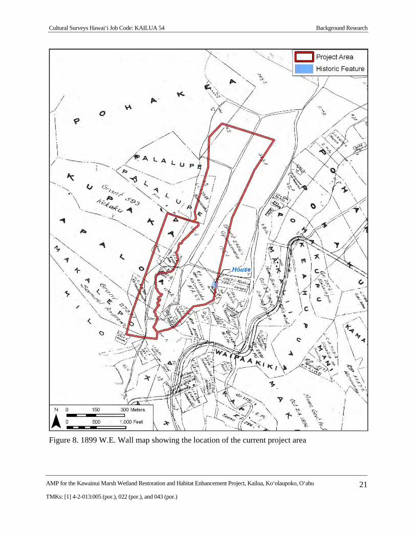
An 1899 Wall map shows more accurately the true complexity of ownership with the large land divisions of Kupaka, Kapalo, and Makalepo extending down from the summit of the Oneawa Hills to the west edge of the marsh and a large number of Land Commission Awards and later grants within the project area (Figure 8). A somewhat braided network of water flow between Kahanaiki Stream (on the west) and Maunawili Stream (on the east) is indicated. A small structure appears to be shown near the southeast side of the project area on the east side of Royal Patent 4533.1 to Kalawaiaku and just west of LCA 2544 to Lalapa.
Cultural Surveys Hawai‘i Job Code: KAILUA 54 Background Research
AMP for the Kawainui Marsh Wetland Restoration and Habitat Enhancement Project, Kailua, Ko‘olaupoko, O‘ahu 20
TMKs: [1] 4-2-013:005 (por.), 022 (por.), and 043 (por.)
Table 1. Land Commission Awards Located within the Current Project Area
Land Claim #
Claimant ‘Ili (Land Division)
Land Use for Project Area Lands
Acreage Awarded
Royal Patent
2544 Lalapa Ukikolo, Manu
Four lo‘i and a house site, claims for a small orange and lime grove appear to be elsewhere
Two ‘āpana; 6.46 acres and 1.38 acres
RP 2291
2575 Hekona Manulele Five lo‘i in each of two parcels
Two ‘āpana; 2.29 acres
RP 2318
6153 Nanawahine Manulele Two lo‘i One ‘āpana; 0.22 acres
No RP
6162 Punipeki Olohana Two (possibly 12) lo‘i One ‘āpana; 0.47 acres, not awarded
RP 2135
6807 K. Kapano Kamakalepo and Kaaimoku
Claims four parcels including three of lo‘i (four, eight, and four patches) and a house lot
Kamakalepo two ‘āpana; 11.59 acres; Pehialii; one ‘āpana; 1.76 acres
RP 2141
6808 Poniuohua Kamakalepo 15 lo‘i Two ‘āpana; 5.254 acres
RP 3761
6813 Keli‘i-kanaka‘ole
Kamakalepo 12 (15?) lo‘i Three ‘āpana; 7.126 acres
RP 2139
7113:1 and 2
Keaka ½ Manu ‘Ili taro lands One ‘āpana; 1.52 acres One ‘āpana; 1.52 acres
RP 1652
7588 O Kamo‘o-nohu Palahele ? One ‘āpana; 7.88 acres
RP 7285
8797 Kao‘o Kapalaoa One kula, one house lot one hala tree
Two ‘āpana; 2.61 acres
RP 2142
8799 Kekaua-kamali‘i
Kapalaoa Nine lo‘i and a kula parcel
One ‘āpana; 2.66 acres
R.P 2528
Cultural Surveys Hawai‘i Job Code: KAILUA 54 Background Research
AMP for the Kawainui Marsh Wetland Restoration and Habitat Enhancement Project, Kailua, Ko‘olaupoko, O‘ahu 21
TMKs: [1] 4-2-013:005 (por.), 022 (por.), and 043 (por.)
Figure 8. 1899 W.E. Wall map showing the location of the current project area
Cultural Surveys Hawai‘i Job Code: KAILUA 54 Background Research
AMP for the Kawainui Marsh Wetland Restoration and Habitat Enhancement Project, Kailua, Ko‘olaupoko, O‘ahu 22
TMKs: [1] 4-2-013:005 (por.), 022 (por.), and 043 (por.)
2.1.4 1900s
In the early 1900s Kāneohe Ranch came to dominate land holdings in the Kailua and Kāne‘ohe area. Included within this acreage is much ranch land which has been bought, sold, let, and used as ranch land by numerous parties since the mid-1850s. Kelly and Nakamura’s (1981:34-35) history mentions that Government land sales amounting to 3,000 acres were sold to 21 buyers in Kailua between the years 1849 and 1863. The largest parcel went to William Jarrett of the ‘ili of Maunawili in 1849. The second largest was 399.5 acres to T. Cummins in Mokulua. Both parcels were used for ranching. Other land holdings which were turned into ranch land in the mid-1850s included the ‘ili of Puanea and ‘Ohua‘uli (by the son of Paula Marin, Paul F. Manini). These large land holdings were used for years as ranch lands before becoming part of the Castle’s Kāneohe Ranch. Cattle, sheep, and horses, were thus allowed to roam at will through many parts of Kailua, and would have destroyed many gardens and abandoned habitation areas. Kelly and Nakamura point out that although specific records are not available, based on tax information, it is not unreasonable to estimate that several thousand head of cattle were grazing in Kailua by 1875 (Kelly and Nakamura 1981:69).
Kāneohe Ranch (Castle Trust) eventually acquired much of the land in Kailua (Hall 1997:84). Kāneohe Ranch, in addition to ranching, grew pineapple and sugarcane. With the decline of rice farming around the margins of Kawainui, cattle stock moved onto the abandoned agricultural lands. Ranching in Kailua continues to this day, albeit on a drastically reduced scale.
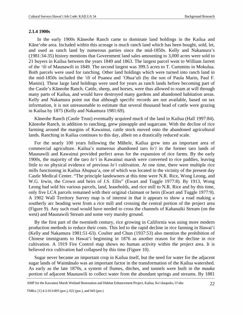
For the nearly 100 years following the Māhele, Kailua grew into an important area of commercial agriculture. Kailua’s numerous abandoned taro lo‘i in the former taro lands of Maunawili and Kawainui provided perfect areas for the expansion of rice farms. By the early 1900s, the majority of the taro lo‘i in Kawainui marsh were converted to rice paddies, leaving little to no physical evidence of previous lo‘i cultivation. At one time, there were multiple rice mills functioning in Kailua Ahupua‘a, one of which was located in the vicinity of the present day Castle Medical Center. “The principle landowners at this time were N.R. Rice, Wong Leong, and W.G. Irwin, the Crown and heirs of J.S. Ellis” (Ewart and Tuggle 1977:8). By 1913, Wong Leong had sold his various parcels, land, leaseholds, and rice mill to N.R. Rice and by this time, only five LCA parcels remained with their original claimant or heirs (Ewart and Tuggle 1977:9). A 1902 Wall Territory Survey map is of interest in that it appears to show a road making a southerly arc heading west from a rice mill and crossing the central portion of the project area (Figure 9). Any such road would have needed to cross the channels of Kahanaiki Stream (on the west) and Maunawili Stream and some very marshy ground.
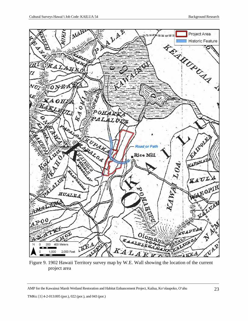
By the first part of the twentieth century, rice growing in California was using more modern production methods to reduce their costs. This led to the rapid decline in rice farming in Hawai‘i (Kelly and Nakamura 1981:51-63). Coulter and Chun (1937:53) also mention the prohibition of Chinese immigrants to Hawai‘i beginning in 1876 as another reason for the decline in rice cultivation. A 1919 Fire Control map shows no human activity within the project area. It is believed rice cultivation had collapsed by this time (Figure 10).
Sugar never became an important crop in Kailua itself, but the need for water for the adjacent sugar lands of Waimānalo was an important factor in the transformation of the Kailua watershed. As early as the late 1870s, a system of flumes, ditches, and tunnels were built in the mauka portion of adjacent Maunawili to collect water from the abundant springs and streams. By 1881
Cultural Surveys Hawai‘i Job Code: KAILUA 54 Background Research
AMP for the Kawainui Marsh Wetland Restoration and Habitat Enhancement Project, Kailua, Ko‘olaupoko, O‘ahu 23
TMKs: [1] 4-2-013:005 (por.), 022 (por.), and 043 (por.)
Figure 9. 1902 Hawaii Territory survey map by W.E. Wall showing the location of the current project area
Cultural Surveys Hawai‘i Job Code: KAILUA 54 Background Research
AMP for the Kawainui Marsh Wetland Restoration and Habitat Enhancement Project, Kailua, Ko‘olaupoko, O‘ahu 24
TMKs: [1] 4-2-013:005 (por.), 022 (por.), and 043 (por.)
Figure 10. 1919 Fire Control map, Waimanalo Quadrangle showing the location of the current project area
Cultural Surveys Hawai‘i Job Code: KAILUA 54 Background Research
AMP for the Kawainui Marsh Wetland Restoration and Habitat Enhancement Project, Kailua, Ko‘olaupoko, O‘ahu 25
TMKs: [1] 4-2-013:005 (por.), 022 (por.), and 043 (por.)
close to 1,000 acres of sugar had been planted, and milling operations were underway in Waimānalo (Kelly and Nakamura 1981:76). Expansion in acreage continued, increasing the need for water. By the 1920s, improvements to the Waimānalo Irrigation System included catchment tunnels excavated into the base of the Ko‘olau in Maunawili to increase flow.
Also completed in 1923 was a system of pumps, pipelines, tunnels, and ditches, which conducted water from Kawainui Marsh into the Kailua ditch, a portion of the Waimānalo Irrigation System. This system continued to supply Kawainui water to Waimānalo until the early 1950s (Hall 1997:94; Harland, Bartholomew, and Associates 1959:53-54; Kelly and Nakamura 1981:778-79). According to Wilcox (1996:111), two pumps lifted water from Kawainui and took it to the head of a 10,000-ft system of small tunnels, most through stone or hard earth, into a reservoir in Waimānalo.
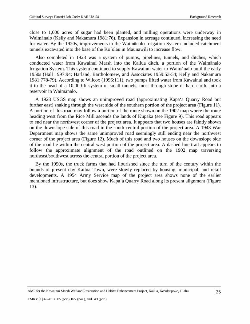
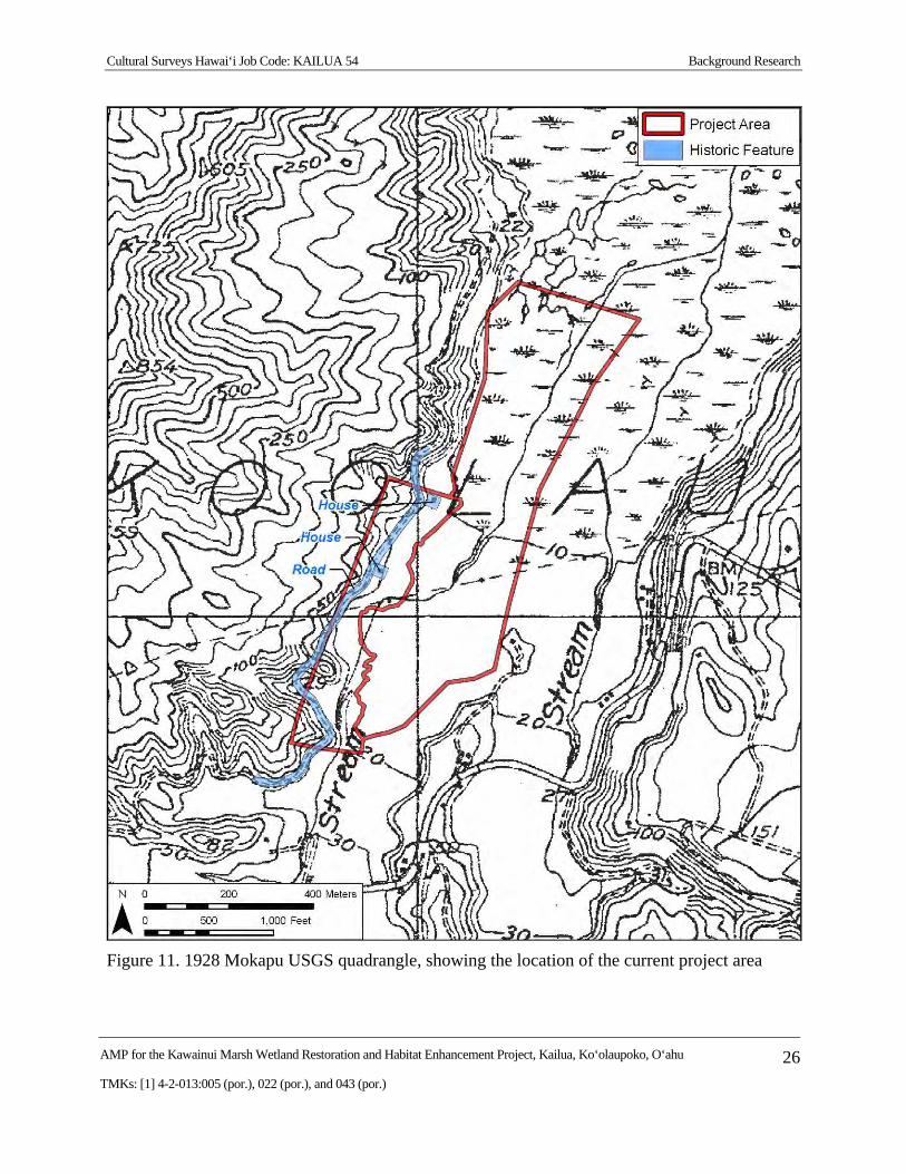
A 1928 USGS map shows an unimproved road (approximating Kapa‘a Quarry Road but further east) snaking through the west side of the southern portion of the project area (Figure 11). A portion of this road may follow a portion of the route shown on the 1902 map where the route heading west from the Rice Mill ascends the lands of Kupaka (see Figure 9). This road appears to end near the northwest corner of the project area. It appears that two houses are faintly shown on the downslope side of this road in the south central portion of the project area. A 1943 War Department map shows the same unimproved road seemingly still ending near the northwest corner of the project area (Figure 12). Much of this road and two houses on the downslope side of the road lie within the central west portion of the project area. A dashed line trail appears to follow the approximate alignment of the road outlined on the 1902 map traversing northeast/southwest across the central portion of the project area.
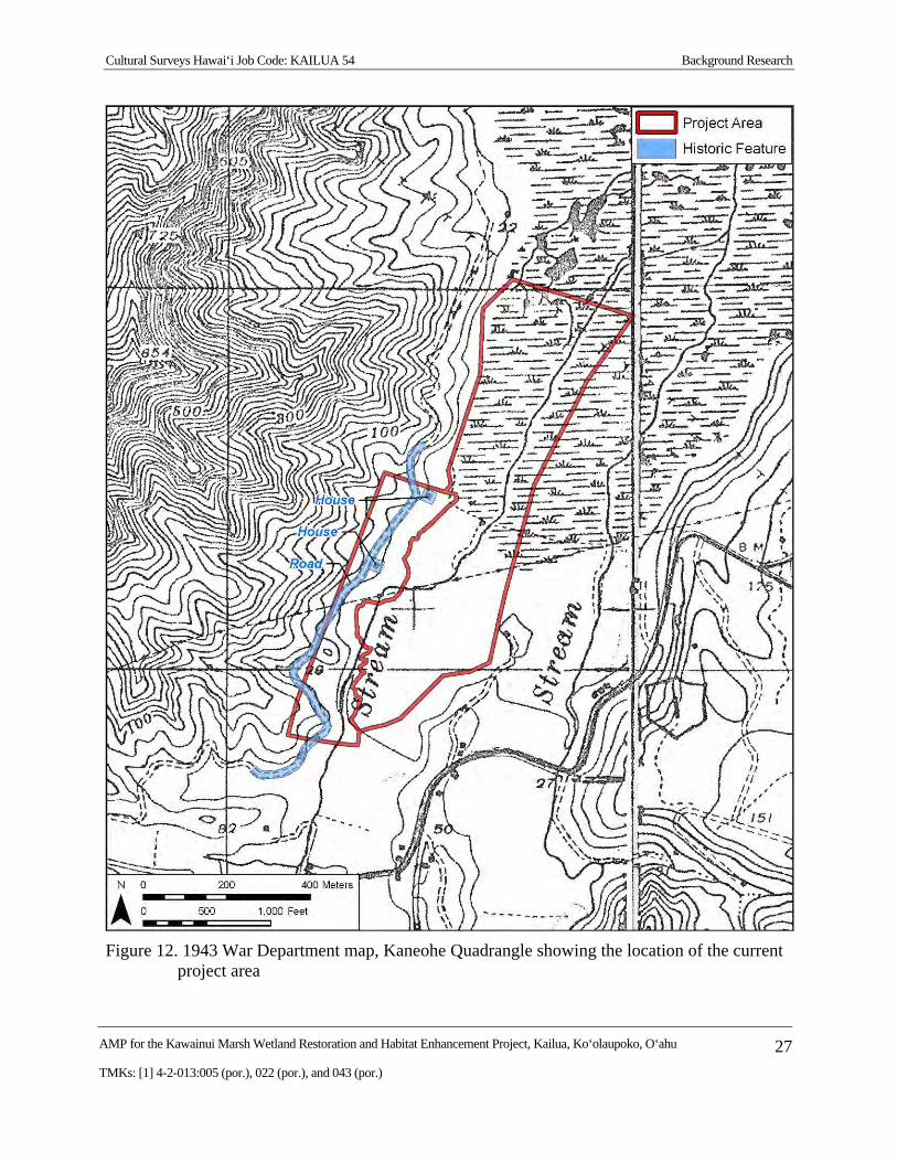
By the 1950s, the truck farms that had flourished since the turn of the century within the bounds of present day Kailua Town, were slowly replaced by housing, municipal, and retail developments. A 1954 Army Service map of the project area shows none of the earlier mentioned infrastructure, but does show Kapa‘a Quarry Road along its present alignment (Figure 13).
Cultural Surveys Hawai‘i Job Code: KAILUA 54 Background Research
AMP for the Kawainui Marsh Wetland Restoration and Habitat Enhancement Project, Kailua, Ko‘olaupoko, O‘ahu 26
TMKs: [1] 4-2-013:005 (por.), 022 (por.), and 043 (por.)
Figure 11. 1928 Mokapu USGS quadrangle, showing the location of the current project area
Cultural Surveys Hawai‘i Job Code: KAILUA 54 Background Research
AMP for the Kawainui Marsh Wetland Restoration and Habitat Enhancement Project, Kailua, Ko‘olaupoko, O‘ahu 27
TMKs: [1] 4-2-013:005 (por.), 022 (por.), and 043 (por.)
Figure 12. 1943 War Department map, Kaneohe Quadrangle showing the location of the current project area
Cultural Surveys Hawai‘i Job Code: KAILUA 54 Background Research
AMP for the Kawainui Marsh Wetland Restoration and Habitat Enhancement Project, Kailua, Ko‘olaupoko, O‘ahu 28
TMKs: [1] 4-2-013:005 (por.), 022 (por.), and 043 (por.)
Figure 13. 1952 Army Map Service map, Mokapu Quadrangle showing the location of the current project area
Cultural Surveys Hawai‘i Job Code: KAILUA 54 Background Research
AMP for the Kawainui Marsh Wetland Restoration and Habitat Enhancement Project, Kailua, Ko‘olaupoko, O‘ahu 29
TMKs: [1] 4-2-013:005 (por.), 022 (por.), and 043 (por.)
2.2 Previous Archaeological Research in Kailua Ahupua‘a Twentieth century archaeological findings from inventory surveys, data recovery projects, and
inadvertent finds during development are the main source of our knowledge about the archeological record in Kailua. Archaeological work in the last 25 years in Kailua has been fairly extensive. This work has been concentrated along the margins of Kawainui Marsh and within Maunawili Valley for the most part. This is largely due to the fact that most of the makai portions of the ahupua‘a had been developed prior to the implementation of State and Federal historic preservation rules (Dye 1992). The many archaeological reports dealing with Kailua are listed and briefly summarized in Table 2 with the location of select archaeological projects in Figure 14.
Remains of upland terraces show that taro has been grown extensively and intensively in Kailua since the thirteenth or fourteenth century, and possibly earlier (Allen-Wheeler 1981, Williams et al. 1995). The work of Allen (1981, 1986-87), Athens (1983a), and Cordy (1977, 1978) all document the mix of irrigated and dryland agriculture that was carried out in Kailua during prehistory and continuing into the historic period. Dryland agriculture, including yams, gourds, and sweet potato, would have been carried out on slopes and on drier flatlands. Modification to the landscape would have been variable, ranging from none at all to the construction of terraces and mounds for planting. According to Handy (1940:155) the beach barrier at Kailua (current day Coconut Grove) was famous for its production of sweet potatoes grown in small mounds. Irrigated agriculture would have been carried out along streams and below springs. Associated landscape modifications would have included construction of terraces and/or pondfields, ‘auwai, and earthen and stacked-stone berms. These types of dryland and irrigated agricultural features have been found in Maunawili and along the margins of Kawainui Marsh.
Previous archaeological investigations in Kailua have located dispersed prehistoric habitation remnants. This is in keeping with the observations of early Westerners in Hawai‘i that the settlement pattern for the most part was dispersed habitations scattered across the landscape amid agricultural fields. It should be remembered that settlement data is conspicuously absent from the lowland, beach berm areas of Kailua, due to early development of these areas.
McAllister (1933) reported eight heiau within the ahupua‘a of Kailua, and it is not unreasonable to conclude there were several more of which McAllister’s informants had no knowledge. This is well in keeping with Kailua’s status as a productive ahupua‘a, the residence of ali‘i. The three known heiau closest to the current project area are McAllister’s sites 359 Pahukini Heiau, 360 Holomakani Heiau, and 371 Ulupō Heiau.
In the last 11 years over 15 reports of inadvertent finds of human skeletal remains have been made in Kailua, on the sandy beach berm of Coconut Grove and Lanikai. As with other near shore sandy areas in Hawai‘i, clearly Kailua was used for burial of the dead. These burial remains are not nearly as extensive, however, as the hundreds of human burials discovered from nearby Mōkapu peninsula (Snow 1974).
Cultural Surveys Hawai‘i Job Code: KAILUA 54 Background Research
AMP for the Kawainui Marsh Wetland Restoration and Habitat Enhancement Project, Kailua, Ko‘olaupoko, O‘ahu 30
TMKs: [1] 4-2-013:005 (por.), 022 (por.), and 043 (por.)
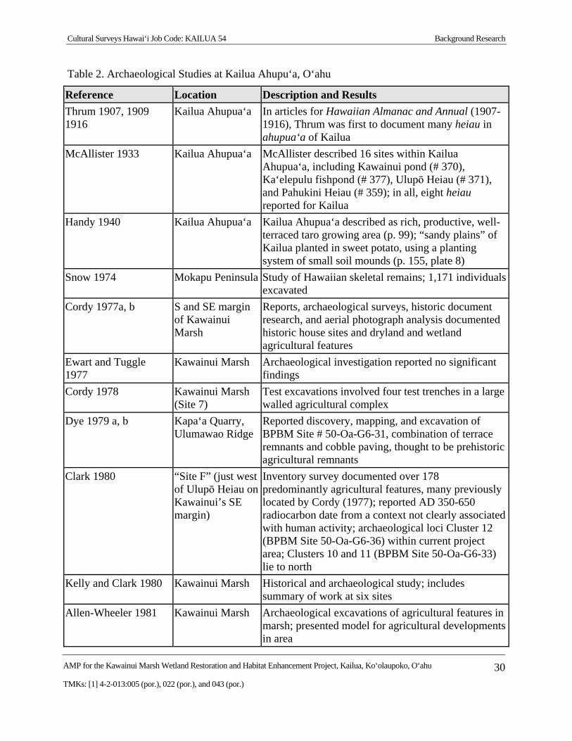
Table 2. Archaeological Studies at Kailua Ahupu‘a, O‘ahu
Reference Location Description and Results
Thrum 1907, 1909 1916
Kailua Ahupua‘a In articles for Hawaiian Almanac and Annual (1907-1916), Thrum was first to document many heiau in ahupua‘a of Kailua
McAllister 1933 Kailua Ahupua‘a McAllister described 16 sites within Kailua Ahupua‘a, including Kawainui pond (# 370), Ka‘elepulu fishpond (# 377), Ulupō Heiau (# 371), and Pahukini Heiau (# 359); in all, eight heiau reported for Kailua
Handy 1940 Kailua Ahupua‘a Kailua Ahupua‘a described as rich, productive, well-terraced taro growing area (p. 99); “sandy plains” of Kailua planted in sweet potato, using a planting system of small soil mounds (p. 155, plate 8)
Snow 1974 Mokapu Peninsula Study of Hawaiian skeletal remains; 1,171 individuals excavated
Cordy 1977a, b S and SE margin of Kawainui Marsh
Reports, archaeological surveys, historic document research, and aerial photograph analysis documented historic house sites and dryland and wetland agricultural features
Ewart and Tuggle 1977
Kawainui Marsh Archaeological investigation reported no significant findings
Cordy 1978 Kawainui Marsh (Site 7)
Test excavations involved four test trenches in a large walled agricultural complex
Dye 1979 a, b Kapa‘a Quarry, Ulumawao Ridge
Reported discovery, mapping, and excavation of BPBM Site # 50-Oa-G6-31, combination of terrace remnants and cobble paving, thought to be prehistoric agricultural remnants
Clark 1980 “Site F” (just west of Ulupō Heiau on Kawainui’s SE margin)
Inventory survey documented over 178 predominantly agricultural features, many previously located by Cordy (1977); reported AD 350-650 radiocarbon date from a context not clearly associated with human activity; archaeological loci Cluster 12 (BPBM Site 50-Oa-G6-36) within current project area; Clusters 10 and 11 (BPBM Site 50-Oa-G6-33) lie to north
Kelly and Clark 1980 Kawainui Marsh Historical and archaeological study; includes summary of work at six sites
Allen-Wheeler 1981 Kawainui Marsh Archaeological excavations of agricultural features in marsh; presented model for agricultural developments in area
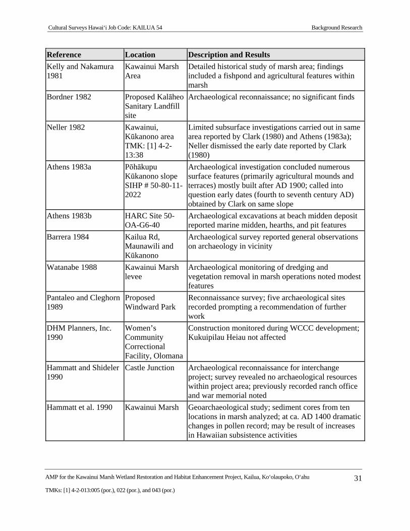
Cultural Surveys Hawai‘i Job Code: KAILUA 54 Background Research
AMP for the Kawainui Marsh Wetland Restoration and Habitat Enhancement Project, Kailua, Ko‘olaupoko, O‘ahu 31
TMKs: [1] 4-2-013:005 (por.), 022 (por.), and 043 (por.)
Reference Location Description and Results
Kelly and Nakamura 1981
Kawainui Marsh Area
Detailed historical study of marsh area; findings included a fishpond and agricultural features within marsh
Bordner 1982 Proposed Kalāheo Sanitary Landfill site
Archaeological reconnaissance; no significant finds
Neller 1982 Kawainui, Kūkanono area TMK: [1] 4-2-13:38
Limited subsurface investigations carried out in same area reported by Clark (1980) and Athens (1983a); Neller dismissed the early date reported by Clark (1980)
Athens 1983a Pōhākupu Kūkanono slope SIHP # 50-80-11-2022
Archaeological investigation concluded numerous surface features (primarily agricultural mounds and terraces) mostly built after AD 1900; called into question early dates (fourth to seventh century AD) obtained by Clark on same slope
Athens 1983b HARC Site 50-OA-G6-40
Archaeological excavations at beach midden deposit reported marine midden, hearths, and pit features
Barrera 1984 Kailua Rd, Maunawili and Kūkanono
Archaeological survey reported general observations on archaeology in vicinity
Watanabe 1988 Kawainui Marsh levee
Archaeological monitoring of dredging and vegetation removal in marsh operations noted modest features
Pantaleo and Cleghorn 1989
Proposed Windward Park
Reconnaissance survey; five archaeological sites recorded prompting a recommendation of further work
DHM Planners, Inc. 1990
Women’s Community Correctional Facility, Olomana
Construction monitored during WCCC development; Kukuipilau Heiau not affected
Hammatt and Shideler 1990
Castle Junction Archaeological reconnaissance for interchange project; survey revealed no archaeological resources within project area; previously recorded ranch office and war memorial noted
Hammatt et al. 1990 Kawainui Marsh Geoarchaeological study; sediment cores from ten locations in marsh analyzed; at ca. AD 1400 dramatic changes in pollen record; may be result of increases in Hawaiian subsistence activities
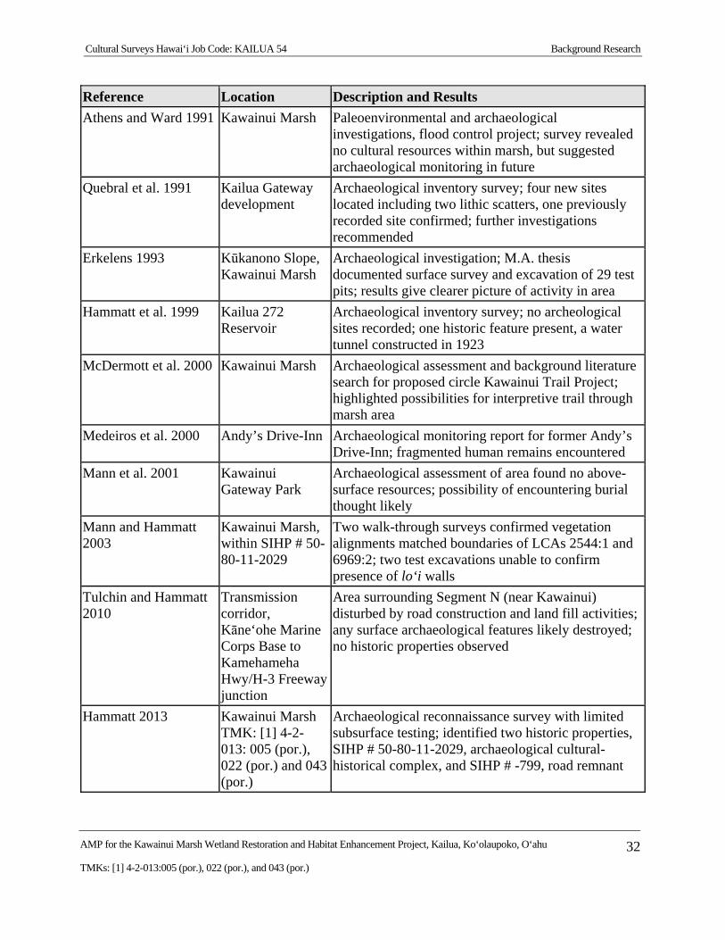
Cultural Surveys Hawai‘i Job Code: KAILUA 54 Background Research
AMP for the Kawainui Marsh Wetland Restoration and Habitat Enhancement Project, Kailua, Ko‘olaupoko, O‘ahu 32
TMKs: [1] 4-2-013:005 (por.), 022 (por.), and 043 (por.)
Reference Location Description and Results
Athens and Ward 1991 Kawainui Marsh Paleoenvironmental and archaeological investigations, flood control project; survey revealed no cultural resources within marsh, but suggested archaeological monitoring in future
Quebral et al. 1991 Kailua Gateway development
Archaeological inventory survey; four new sites located including two lithic scatters, one previously recorded site confirmed; further investigations recommended
Erkelens 1993 Kūkanono Slope, Kawainui Marsh
Archaeological investigation; M.A. thesis documented surface survey and excavation of 29 test pits; results give clearer picture of activity in area
Hammatt et al. 1999 Kailua 272 Reservoir
Archaeological inventory survey; no archeological sites recorded; one historic feature present, a water tunnel constructed in 1923
McDermott et al. 2000 Kawainui Marsh Archaeological assessment and background literature search for proposed circle Kawainui Trail Project; highlighted possibilities for interpretive trail through marsh area
Medeiros et al. 2000 Andy’s Drive-Inn Archaeological monitoring report for former Andy’s Drive-Inn; fragmented human remains encountered
Mann et al. 2001 Kawainui Gateway Park
Archaeological assessment of area found no above-surface resources; possibility of encountering burial thought likely
Mann and Hammatt 2003
Kawainui Marsh, within SIHP # 50-80-11-2029
Two walk-through surveys confirmed vegetation alignments matched boundaries of LCAs 2544:1 and 6969:2; two test excavations unable to confirm presence of lo‘i walls
Tulchin and Hammatt 2010
Transmission corridor, Kāne‘ohe Marine Corps Base to Kamehameha Hwy/H-3 Freeway junction
Area surrounding Segment N (near Kawainui) disturbed by road construction and land fill activities; any surface archaeological features likely destroyed; no historic properties observed
Hammatt 2013 Kawainui Marsh TMK: [1] 4-2-013: 005 (por.), 022 (por.) and 043 (por.)
Archaeological reconnaissance survey with limited subsurface testing; identified two historic properties, SIHP # 50-80-11-2029, archaeological cultural-historical complex, and SIHP # -799, road remnant
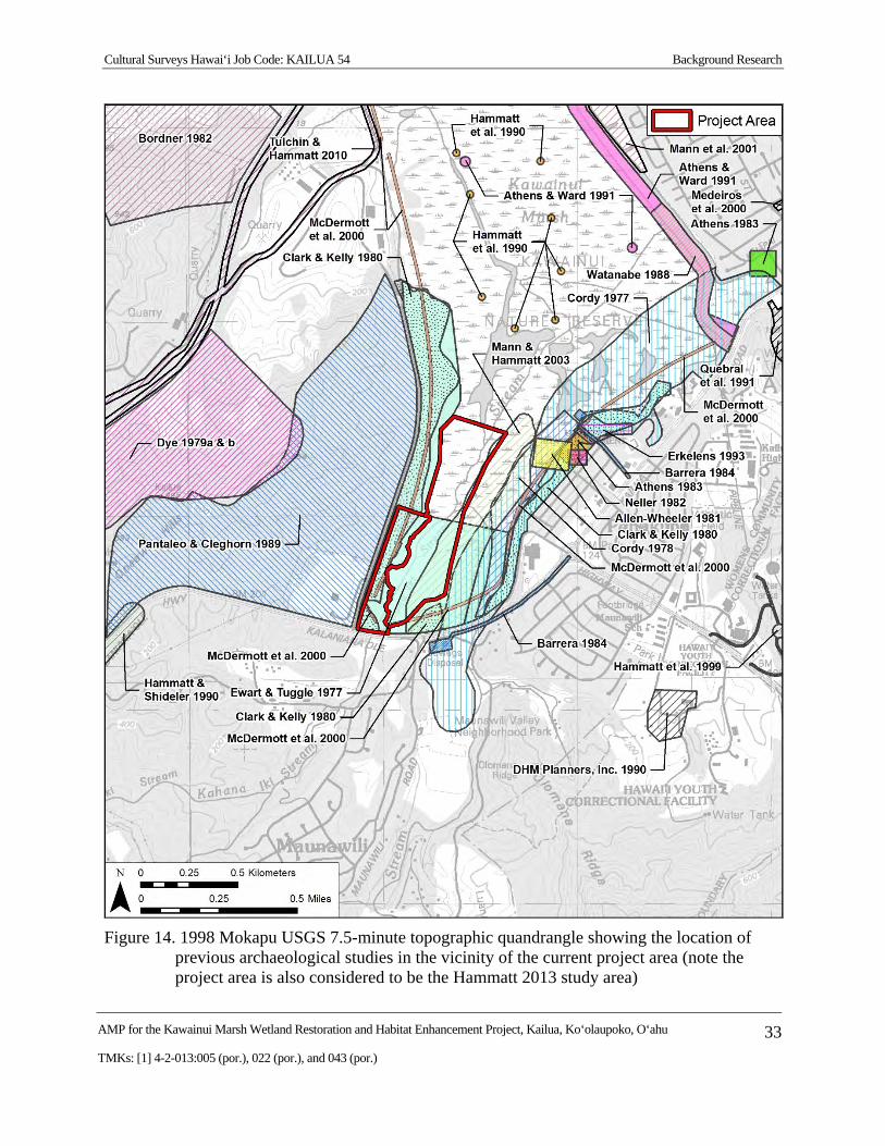
Cultural Surveys Hawai‘i Job Code: KAILUA 54 Background Research
AMP for the Kawainui Marsh Wetland Restoration and Habitat Enhancement Project, Kailua, Ko‘olaupoko, O‘ahu 33
TMKs: [1] 4-2-013:005 (por.), 022 (por.), and 043 (por.)
Figure 14. 1998 Mokapu USGS 7.5-minute topographic quandrangle showing the location of previous archaeological studies in the vicinity of the current project area (note the project area is also considered to be the Hammatt 2013 study area)
Cultural Surveys Hawai‘i Job Code: KAILUA 54 Background Research
AMP for the Kawainui Marsh Wetland Restoration and Habitat Enhancement Project, Kailua, Ko‘olaupoko, O‘ahu 34
TMKs: [1] 4-2-013:005 (por.), 022 (por.), and 043 (por.)
2.3 Most Relevant Archaeological Reports Conducted in Kawainui Marsh
Most relevant to the current project area are a dozen archaeological investigations by Allen-Wheeler (1981), Athens (1983a, b), Athens and Ward (1991), Clark (1980), Cordy (1977, 1978), Erkelens (1993), Ewart and Tuggle (1977), Hammatt et al. (1990), Mann and Hammatt (2003), and Neller (1982).
2.3.1 Ewart and Tuggle (1977)
An archaeological reconnaissance survey and historic literature review of Kawainui Marsh was undertaken in 1977 by Ewart and Tuggle (1977). Their somewhat U-shaped study area (Figure 15) consisted of an area of higher ground between Maunawili and Kahana Iki streams at the south end of the marsh, and the slopes between the marsh and Quarry Road as far north as the Kapa‘a Quarry on the west and the southeastern slopes between the marsh and modern developments as far north as St. John’s Lutheran Church on the east. As a result of the reconnaissance survey, six archaeological features (Site 1 through Site 6) were identified on the Kūkanono-Pōhākupu slope (summarized in Table 3). With the exception of a single terrace on the west side of the marsh and two abandoned modern house sites near H-3, no cultural remains were noted in the remainder of the project area. The authors note, however, that cultural deposits may exist in the area between Maunawili and Kahana Iki streams and along the marsh periphery, but due to historic surface alterations and vegetation coverings, these areas were not visible to ground surveyors. Subsequently, the authors recommended archaeological monitoring in the area between Maunawili and Kahana Iki streams.
Only one of the nine sites identified by Ewart and Tuggle (1977) lies near, but outside (just northwest of the northwest corner of) the present project area—their Site 7 consisting of a terrace and stone wall (Figure 15). No map is provided for this site and the description is brief (summarized in full in the table below). Their evaluation of Site 7 is lumped with an evaluation of several other sites that “offer very poor research prospects. They are all isolated, badly disturbed, and for the most part, historic sites. Their status is recommended to be considered as MARGINAL” (Ewart and Tuggle 1977:24).
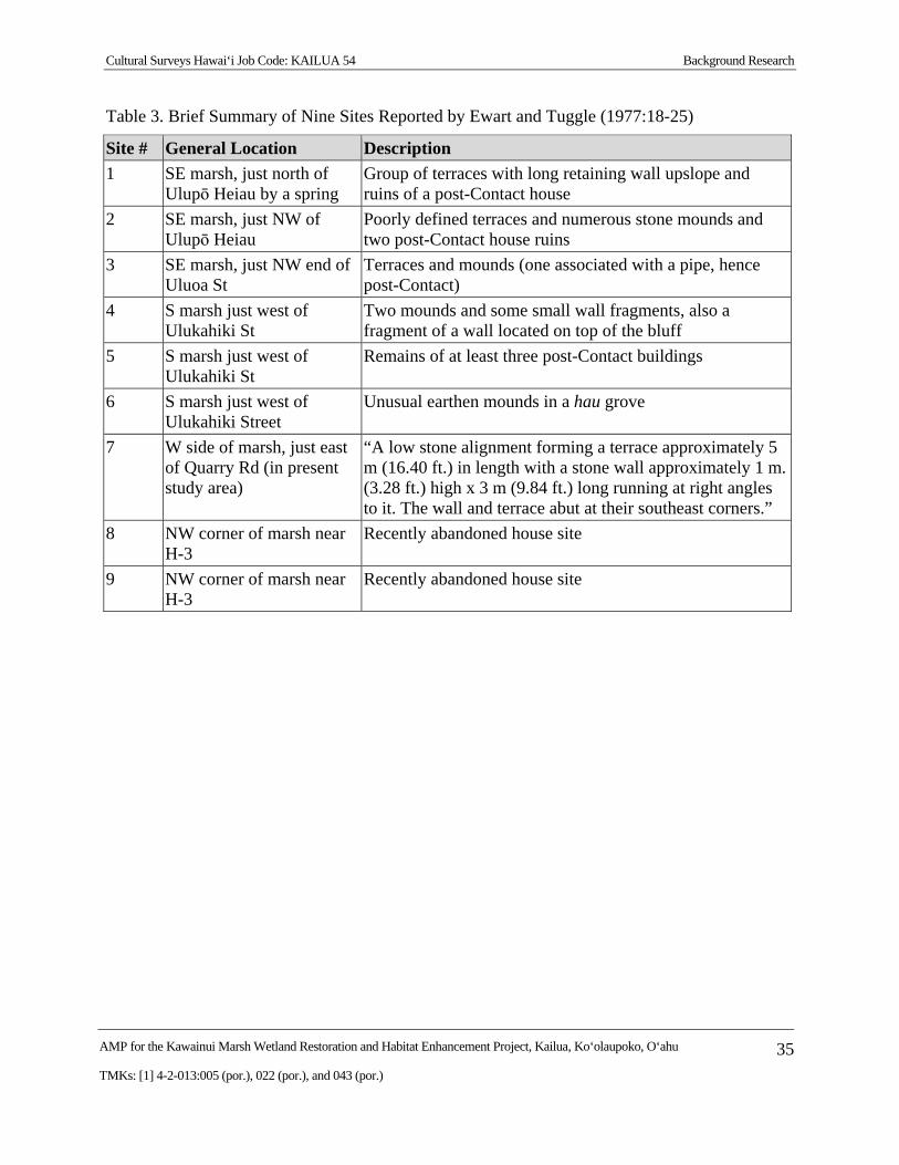
Cultural Surveys Hawai‘i Job Code: KAILUA 54 Background Research
AMP for the Kawainui Marsh Wetland Restoration and Habitat Enhancement Project, Kailua, Ko‘olaupoko, O‘ahu 35
TMKs: [1] 4-2-013:005 (por.), 022 (por.), and 043 (por.)
Table 3. Brief Summary of Nine Sites Reported by Ewart and Tuggle (1977:18-25)
Site # General Location Description
1 SE marsh, just north of Ulupō Heiau by a spring
Group of terraces with long retaining wall upslope and ruins of a post-Contact house
2 SE marsh, just NW of Ulupō Heiau
Poorly defined terraces and numerous stone mounds and two post-Contact house ruins
3 SE marsh, just NW end of Uluoa St
Terraces and mounds (one associated with a pipe, hence post-Contact)
4 S marsh just west of Ulukahiki St
Two mounds and some small wall fragments, also a fragment of a wall located on top of the bluff
5 S marsh just west of Ulukahiki St
Remains of at least three post-Contact buildings
6 S marsh just west of Ulukahiki Street
Unusual earthen mounds in a hau grove
7 W side of marsh, just east of Quarry Rd (in present study area)
“A low stone alignment forming a terrace approximately 5 m (16.40 ft.) in length with a stone wall approximately 1 m. (3.28 ft.) high x 3 m (9.84 ft.) long running at right angles to it. The wall and terrace abut at their southeast corners.”
8 NW corner of marsh near H-3
Recently abandoned house site
9 NW corner of marsh near H-3
Recently abandoned house site
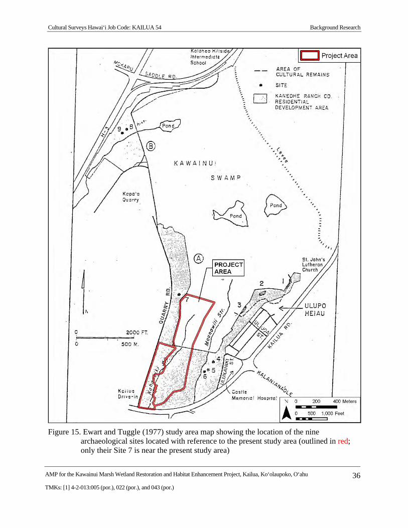
Cultural Surveys Hawai‘i Job Code: KAILUA 54 Background Research
AMP for the Kawainui Marsh Wetland Restoration and Habitat Enhancement Project, Kailua, Ko‘olaupoko, O‘ahu 36
TMKs: [1] 4-2-013:005 (por.), 022 (por.), and 043 (por.)
Figure 15. Ewart and Tuggle (1977) study area map showing the location of the nine archaeological sites located with reference to the present study area (outlined in red; only their Site 7 is near the present study area)
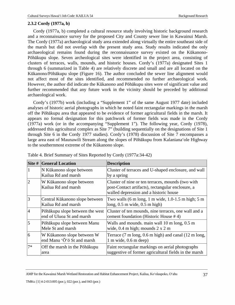
Cultural Surveys Hawai‘i Job Code: KAILUA 54 Background Research
AMP for the Kawainui Marsh Wetland Restoration and Habitat Enhancement Project, Kailua, Ko‘olaupoko, O‘ahu 37
TMKs: [1] 4-2-013:005 (por.), 022 (por.), and 043 (por.)
2.3.2 Cordy (1977a, b)
Cordy (1977a, b) completed a cultural resource study involving historic background research and a reconnaissance survey for the proposed City and County sewer line in Kawainui Marsh. The Cordy (1977a) archaeological study area extended along virtually the entire southeast side of the marsh but did not overlap with the present study area. Study results indicated the only archaeological remains found during the reconnaissance survey existed on the Kūkanono-Pōhākupu slope. Seven archeological sites were identified in the project area, consisting of clusters of terraces, walls, mounds, and historic houses. Cordy’s (1977a) designated Sites 1 through 6 (summarized in Table 4) are relatively discrete and small and are all located on the Kūkanono/Pōhākupu slope (Figure 16). The author concluded the sewer line alignment would not affect most of the sites identified, and recommended no further archaeological work. However, the author did indicate the Kūkanono and Pōhākupu sites were of significant value and further recommended that any future work in the vicinity should be preceded by additional archaeological work.
Cordy’s (1977b) work (including a “Supplement 1” of the same August 1977 date) included analyses of historic aerial photographs in which he noted faint rectangular markings in the marsh off the Pōhākupu area that appeared to be evidence of former agricultural fields in the marsh. It appears no formal designation for this patchwork of former fields was made in the Cordy (1977a) work (or in the accompanying “Supplement 1”). The following year, Cordy (1978), addressed this agricultural complex as Site 7” (building sequentially on the designations of Site 1 through Site 6 in the Cordy 1977 studies). Cordy’s (1978) discussion of Site 7 encompasses a large area east of Maunawili Stream along the slopes of Pōhākupu from Kalaniana‘ole Highway to the southernmost extreme of the Kūkanono slope.
Table 4. Brief Summary of Sites Reported by Cordy (1977a:34-42)
Site # General Location Description
1 N Kūkanono slope between Kailua Rd and marsh
Cluster of terraces and U-shaped enclosure, and wall by a spring
2 W Kūkanono slope between Kailua Rd and marsh
Cluster of nine or ten terraces, mounds (two with post-Contact artifacts), rectangular enclosure, a walled depression and a historic house
3 Central Kūkanono slope between Kailua Rd and marsh
Two walls (6 m long, 1 m wide, 1.0-1.5 m high; 5 m long, 0.5 m wide, 0.5 m high)
4 Pōhākupu slope between the west end of Uluoa St and marsh
Cluster of ten mounds, nine terraces, one wall and a cement foundation (Historic House # 4)
5 Pōhākupu slope between Manu Mele St and marsh
Walls and mounds. main wall 10 m long, 0.5 m wide, 0.4 m high; mounds 2 x 2 m
6 W Kūkanono slope between W end Manu ‘Ō‘ō St and marsh
Terrace (7 m long, 0.6 m high) and canal (12 m long, 1 m wide, 0.6 m deep)
7* Off the marsh in the Pōhākupu area
Faint rectangular markings on aerial photographs suggestive of former agricultural fields in the marsh
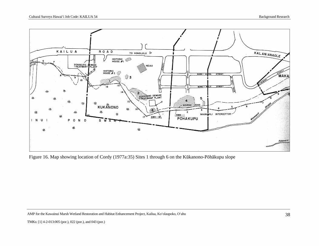
Cultural Surveys Hawai‘i Job Code: KAILUA 54 Background Research
AMP for the Kawainui Marsh Wetland Restoration and Habitat Enhancement Project, Kailua, Ko‘olaupoko, O‘ahu 38
TMKs: [1] 4-2-013:005 (por.), 022 (por.), and 043 (por.)
Figure 16. Map showing location of Cordy (1977a:35) Sites 1 through 6 on the Kūkanono-Pōhākupu slope
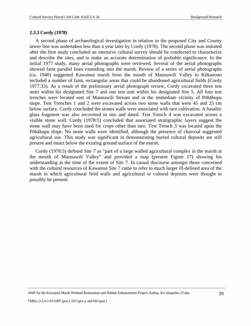
Cultural Surveys Hawai‘i Job Code: KAILUA 54 Background Research
AMP for the Kawainui Marsh Wetland Restoration and Habitat Enhancement Project, Kailua, Ko‘olaupoko, O‘ahu 39
TMKs: [1] 4-2-013:005 (por.), 022 (por.), and 043 (por.)
2.3.3 Cordy (1978)
A second phase of archaeological investigation in relation to the proposed City and County sewer line was undertaken less than a year later by Cordy (1978). The second phase was initiated after the first study concluded an intensive cultural survey should be conducted to characterize and describe the sites, and to make an accurate determination of probable significance. In the initial 1977 study, many aerial photographs were reviewed. Several of the aerial photographs showed faint parallel lines extending into the marsh. Review of a series of aerial photographs (ca. 1940) suggested Kawainui marsh from the mouth of Maunawili Valley to Kūkanono included a number of faint, rectangular areas that could be abandoned agricultural fields (Cordy 1977:33). As a result of the preliminary aerial photograph review, Cordy excavated three test units within his designated Site 7 and one test unit within his designated Site 5. All four test trenches were located east of Maunawili Stream and in the immediate vicinity of Pōhākupu slope. Test Trenches 1 and 2 were excavated across two stone walls that were 45 and 25 cm below surface. Cordy concluded the stones walls were associated with taro cultivation. A basaltic glass fragment was also recovered in situ and dated. Test Trench 4 was excavated across a visible stone wall. Cordy (1978:5) concluded that associated stratigraphic layers suggest the stone wall may have been used for crops other than taro. Test Trench 3 was located upon the Pōhākupu slope. No stone walls were identified, although the presence of charcoal suggested agricultural use. This study was significant in demonstrating buried cultural deposits are still present and intact below the existing ground surface of the marsh.
Cordy (1978:5) defined Site 7 as “part of a large walled agricultural complex in the marsh at the mouth of Maunawili Valley” and provided a map (present Figure 17) showing his understanding at the time of the extent of Site 7. In casual discourse amongst those concerned with the cultural resources of Kawainui Site 7 came to refer to much larger ill-defined area of the marsh in which agricultural field walls and agricultural or cultural deposits were thought to possibly be present.
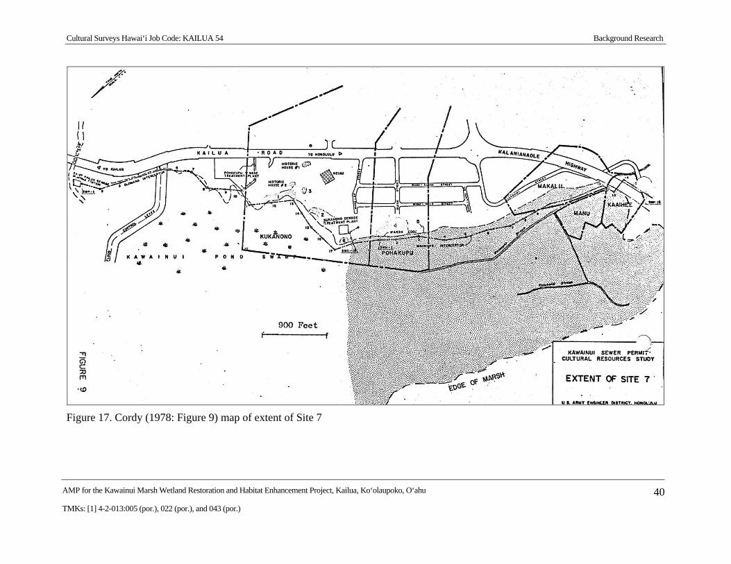
Cultural Surveys Hawai‘i Job Code: KAILUA 54 Background Research
AMP for the Kawainui Marsh Wetland Restoration and Habitat Enhancement Project, Kailua, Ko‘olaupoko, O‘ahu 40
TMKs: [1] 4-2-013:005 (por.), 022 (por.), and 043 (por.)
Figure 17. Cordy (1978: Figure 9) map of extent of Site 7
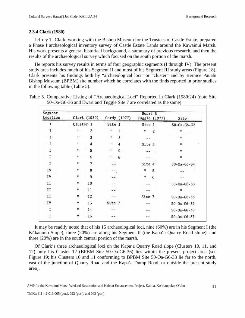
Cultural Surveys Hawai‘i Job Code: KAILUA 54 Background Research
AMP for the Kawainui Marsh Wetland Restoration and Habitat Enhancement Project, Kailua, Ko‘olaupoko, O‘ahu 41
TMKs: [1] 4-2-013:005 (por.), 022 (por.), and 043 (por.)
2.3.4 Clark (1980)
Jeffrey T. Clark, working with the Bishop Museum for the Trustees of Castle Estate, prepared a Phase I archaeological inventory survey of Castle Estate Lands around the Kawainui Marsh. His work presents a general historical background, a summary of previous research, and then the results of the archaeological survey which focused on the south portion of the marsh.
He reports his survey results in terms of four geographic segments (I through IV). The present study area includes much of his Segment II and most of his Segment III study areas (Figure 18). Clark presents his findings both by “archaeological loci” or “cluster” and by Bernice Pauahi Bishop Museum (BPBM) site number which he correlates with the finds reported in prior studies in the following table (Table 5).
Table 5. Comparative Listing of “Archaeological Loci” Reported in Clark (1980:24) (note Site 50-Oa-G6-36 and Ewart and Tuggle Site 7 are correlated as the same)
It may be readily noted that of his 15 archaeological loci, nine (60%) are in his Segment I (the Kūkanono Slope), three (20%) are along his Segment II (the Kapa‘a Quarry Road slope), and three (20%) are in the south central portion of the marsh.
Of Clark’s three archaeological loci on the Kapa‘a Quarry Road slope (Clusters 10, 11, and 12) only his Cluster 12 (BPBM Site 50-Oa-G6-36) lies within the present project area (see Figure 19; his Clusters 10 and 11 conforming to BPBM Site 50-Oa-G6-33 lie far to the north, east of the junction of Quarry Road and the Kapa‘a Dump Road, or outside the present study area).
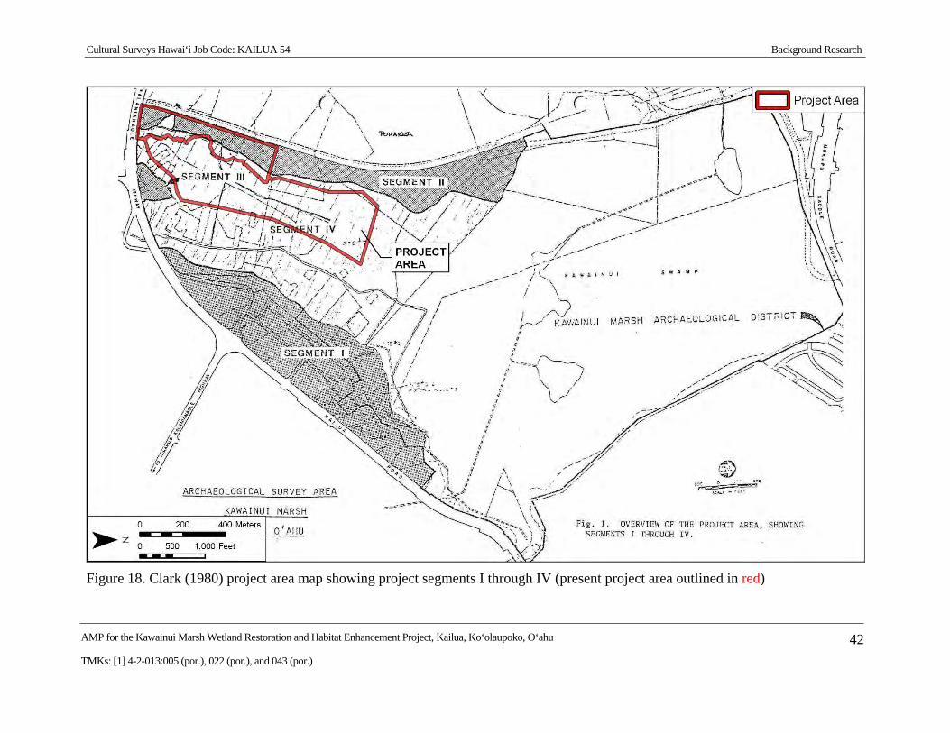
Cultural Surveys Hawai‘i Job Code: KAILUA 54 Background Research
AMP for the Kawainui Marsh Wetland Restoration and Habitat Enhancement Project, Kailua, Ko‘olaupoko, O‘ahu 42
TMKs: [1] 4-2-013:005 (por.), 022 (por.), and 043 (por.)
Figure 18. Clark (1980) project area map showing project segments I through IV (present project area outlined in red)
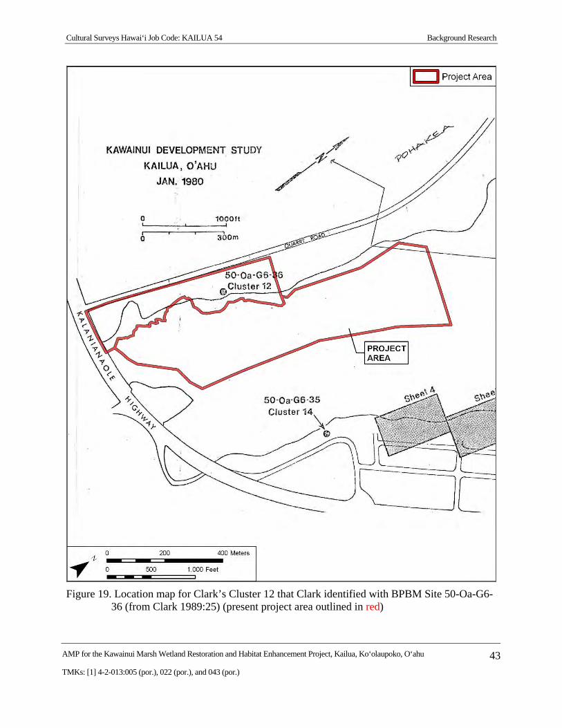
Cultural Surveys Hawai‘i Job Code: KAILUA 54 Background Research
AMP for the Kawainui Marsh Wetland Restoration and Habitat Enhancement Project, Kailua, Ko‘olaupoko, O‘ahu 43
TMKs: [1] 4-2-013:005 (por.), 022 (por.), and 043 (por.)
Figure 19. Location map for Clark’s Cluster 12 that Clark identified with BPBM Site 50-Oa-G6-36 (from Clark 1989:25) (present project area outlined in red)
Cultural Surveys Hawai‘i Job Code: KAILUA 54 Background Research
AMP for the Kawainui Marsh Wetland Restoration and Habitat Enhancement Project, Kailua, Ko‘olaupoko, O‘ahu 44
TMKs: [1] 4-2-013:005 (por.), 022 (por.), and 043 (por.)
Clark’s description of BPBM Site 50-Oa-G6-36, also known to him as Cluster 12, follows:
Site 50-Oa-G6-36
This site is located in Segment II along the marsh edge at a point some 500 meters north of the intersection of Kalanianaole Highway and Quarry Road. It consists of a single cluster, [Clark Cluster designation #] 12, which has a single feature, a large terrace. The terrace walls extend for 65 meters along the marsh edge in a northeast-southwest direction and for 14 meters southeast-northwest. The walls appear to be a single course high and are marked by a somewhat sporadic occurrence of rocks. The terrace itself constitutes a relatively flat region ranging from .5 to 1.5 meters above the surrounding marsh. An old, rusting, dilapidated crane, some 80 m north of the southerly wall, is the most prominent feature of the area. [Clark includes a photo of the vicinity; see present Figure 20].
No test excavation was conducted at this site and the only artifact recovered from the surface was the base from a ceramic bowl [Clark includes a photo of the artifact, see present Figure 21]. The site appears to be an agricultural terrace. [Clark 180:49-51]
Clark’s designation of BPBM Site 50-Oa-G6-36, also known to him as Cluster 12, is particularly germane as it lies within the present study area (see Figure 19). The present study notes the presence in the early twentieth century of a number of roads and houses in this immediate area. It may be that BPBM Site 50-Oa-G6-36 relates largely, or entirely, to these early twentieth century constructions.
Clark’s three site identifications out in the south central marsh include designated Clusters 8 and 9 (no BPBM site # given) and Cluster 13 (identified with BPBM Site # 50-Oa-G6-39). Clark (1980:27) asserts that, “Clusters 8, 9, and 13 are located in Segment IV and are therefore outside the specific project area” and presents no data at all for these sites. Clark equates his Clusters 8 and 9 with Ewart and Tuggle’s Sites 5 and 6—see Table 5 above (from Clark 1980:24).
Clark (1980:72) presented three 14C dates from his work: A. 529-965 and AD 353-655 from his BPBM Site 50-Oa-G6-32 (on the southeast side of Kawainui near the sewage treatment plant, outside of the present study area), and AD 706-898 from his BPBM Site 50-Oa-G6-33 (on the northwest margin of Kawainui, north of the present study area). These were perceived as very early dates for Polynesian settlement and were viewed skeptically by some (Athens 1983:70; Neller 1982:30-33) but found support from others (Erkelens 1993:56).
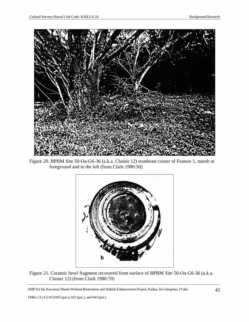
Cultural Surveys Hawai‘i Job Code: KAILUA 54 Background Research
AMP for the Kawainui Marsh Wetland Restoration and Habitat Enhancement Project, Kailua, Ko‘olaupoko, O‘ahu 45
TMKs: [1] 4-2-013:005 (por.), 022 (por.), and 043 (por.)
Figure 20. BPBM Site 50-Oa-G6-36 (a.k.a. Cluster 12) southeast corner of Feature 1, marsh in foreground and to the left (from Clark 1980:50)
Figure 21. Ceramic bowl fragment recovered from surface of BPBM Site 50-Oa-G6-36 (a.k.a. Cluster 12) (from Clark 1980:70)
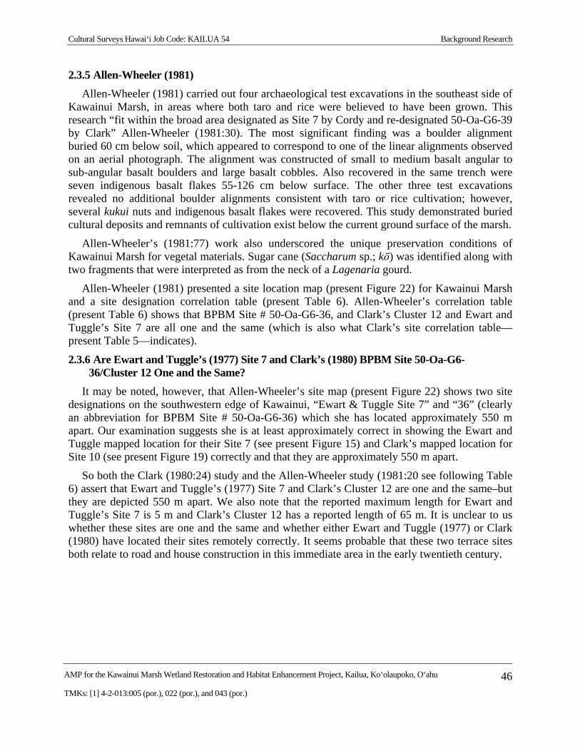
Cultural Surveys Hawai‘i Job Code: KAILUA 54 Background Research
AMP for the Kawainui Marsh Wetland Restoration and Habitat Enhancement Project, Kailua, Ko‘olaupoko, O‘ahu 46
TMKs: [1] 4-2-013:005 (por.), 022 (por.), and 043 (por.)
2.3.5 Allen-Wheeler (1981)
Allen-Wheeler (1981) carried out four archaeological test excavations in the southeast side of Kawainui Marsh, in areas where both taro and rice were believed to have been grown. This research “fit within the broad area designated as Site 7 by Cordy and re-designated 50-Oa-G6-39 by Clark” Allen-Wheeler (1981:30). The most significant finding was a boulder alignment buried 60 cm below soil, which appeared to correspond to one of the linear alignments observed on an aerial photograph. The alignment was constructed of small to medium basalt angular to sub-angular basalt boulders and large basalt cobbles. Also recovered in the same trench were seven indigenous basalt flakes 55-126 cm below surface. The other three test excavations revealed no additional boulder alignments consistent with taro or rice cultivation; however, several kukui nuts and indigenous basalt flakes were recovered. This study demonstrated buried cultural deposits and remnants of cultivation exist below the current ground surface of the marsh.
Allen-Wheeler’s (1981:77) work also underscored the unique preservation conditions of Kawainui Marsh for vegetal materials. Sugar cane (Saccharum sp.; kō) was identified along with two fragments that were interpreted as from the neck of a Lagenaria gourd.
Allen-Wheeler (1981) presented a site location map (present Figure 22) for Kawainui Marsh and a site designation correlation table (present Table 6). Allen-Wheeler’s correlation table (present Table 6) shows that BPBM Site # 50-Oa-G6-36, and Clark’s Cluster 12 and Ewart and Tuggle’s Site 7 are all one and the same (which is also what Clark’s site correlation table—present Table 5—indicates).
2.3.6 Are Ewart and Tuggle’s (1977) Site 7 and Clark’s (1980) BPBM Site 50-Oa-G6-36/Cluster 12 One and the Same?
It may be noted, however, that Allen-Wheeler’s site map (present Figure 22) shows two site designations on the southwestern edge of Kawainui, “Ewart & Tuggle Site 7” and “36” (clearly an abbreviation for BPBM Site # 50-Oa-G6-36) which she has located approximately 550 m apart. Our examination suggests she is at least approximately correct in showing the Ewart and Tuggle mapped location for their Site 7 (see present Figure 15) and Clark’s mapped location for Site 10 (see present Figure 19) correctly and that they are approximately 550 m apart.
So both the Clark (1980:24) study and the Allen-Wheeler study (1981:20 see following Table 6) assert that Ewart and Tuggle’s (1977) Site 7 and Clark’s Cluster 12 are one and the same–but they are depicted 550 m apart. We also note that the reported maximum length for Ewart and Tuggle’s Site 7 is 5 m and Clark’s Cluster 12 has a reported length of 65 m. It is unclear to us whether these sites are one and the same and whether either Ewart and Tuggle (1977) or Clark (1980) have located their sites remotely correctly. It seems probable that these two terrace sites both relate to road and house construction in this immediate area in the early twentieth century.
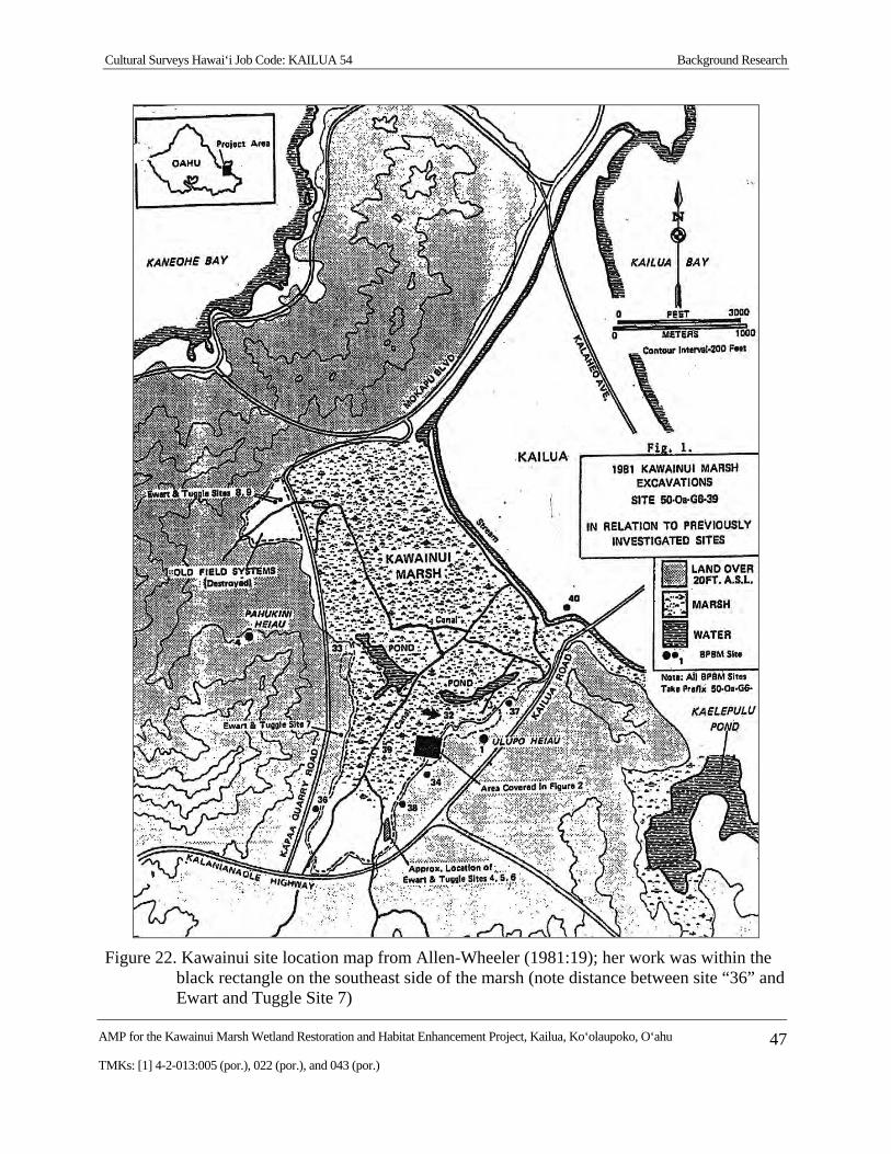
Cultural Surveys Hawai‘i Job Code: KAILUA 54 Background Research
AMP for the Kawainui Marsh Wetland Restoration and Habitat Enhancement Project, Kailua, Ko‘olaupoko, O‘ahu 47
TMKs: [1] 4-2-013:005 (por.), 022 (por.), and 043 (por.)
Figure 22. Kawainui site location map from Allen-Wheeler (1981:19); her work was within the black rectangle on the southeast side of the marsh (note distance between site “36” and Ewart and Tuggle Site 7)
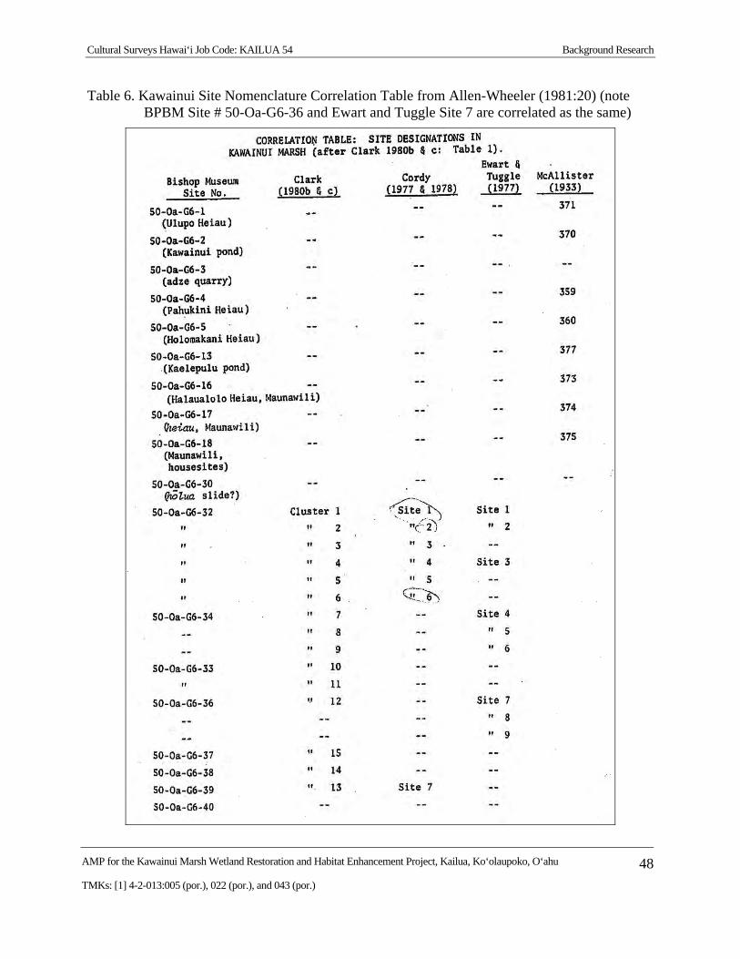
Cultural Surveys Hawai‘i Job Code: KAILUA 54 Background Research
AMP for the Kawainui Marsh Wetland Restoration and Habitat Enhancement Project, Kailua, Ko‘olaupoko, O‘ahu 48
TMKs: [1] 4-2-013:005 (por.), 022 (por.), and 043 (por.)
Table 6. Kawainui Site Nomenclature Correlation Table from Allen-Wheeler (1981:20) (note BPBM Site # 50-Oa-G6-36 and Ewart and Tuggle Site 7 are correlated as the same)
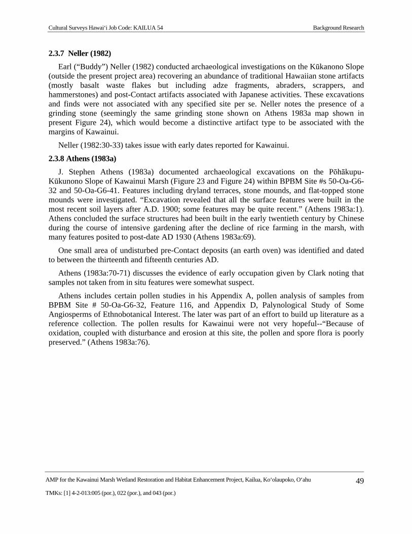
Cultural Surveys Hawai‘i Job Code: KAILUA 54 Background Research
AMP for the Kawainui Marsh Wetland Restoration and Habitat Enhancement Project, Kailua, Ko‘olaupoko, O‘ahu 49
TMKs: [1] 4-2-013:005 (por.), 022 (por.), and 043 (por.)
2.3.7 Neller (1982)
Earl (“Buddy”) Neller (1982) conducted archaeological investigations on the Kūkanono Slope (outside the present project area) recovering an abundance of traditional Hawaiian stone artifacts (mostly basalt waste flakes but including adze fragments, abraders, scrappers, and hammerstones) and post-Contact artifacts associated with Japanese activities. These excavations and finds were not associated with any specified site per se. Neller notes the presence of a grinding stone (seemingly the same grinding stone shown on Athens 1983a map shown in present Figure 24), which would become a distinctive artifact type to be associated with the margins of Kawainui.
Neller (1982:30-33) takes issue with early dates reported for Kawainui.
2.3.8 Athens (1983a)
J. Stephen Athens (1983a) documented archaeological excavations on the Pōhākupu-Kūkunono Slope of Kawainui Marsh (Figure 23 and Figure 24) within BPBM Site #s 50-Oa-G6-32 and 50-Oa-G6-41. Features including dryland terraces, stone mounds, and flat-topped stone mounds were investigated. “Excavation revealed that all the surface features were built in the most recent soil layers after A.D. 1900; some features may be quite recent.” (Athens 1983a:1). Athens concluded the surface structures had been built in the early twentieth century by Chinese during the course of intensive gardening after the decline of rice farming in the marsh, with many features posited to post-date AD 1930 (Athens 1983a:69).
One small area of undisturbed pre-Contact deposits (an earth oven) was identified and dated to between the thirteenth and fifteenth centuries AD.
Athens (1983a:70-71) discusses the evidence of early occupation given by Clark noting that samples not taken from in situ features were somewhat suspect.
Athens includes certain pollen studies in his Appendix A, pollen analysis of samples from BPBM Site # 50-Oa-G6-32, Feature 116, and Appendix D, Palynological Study of Some Angiosperms of Ethnobotanical Interest. The later was part of an effort to build up literature as a reference collection. The pollen results for Kawainui were not very hopeful--“Because of oxidation, coupled with disturbance and erosion at this site, the pollen and spore flora is poorly preserved.” (Athens 1983a:76).
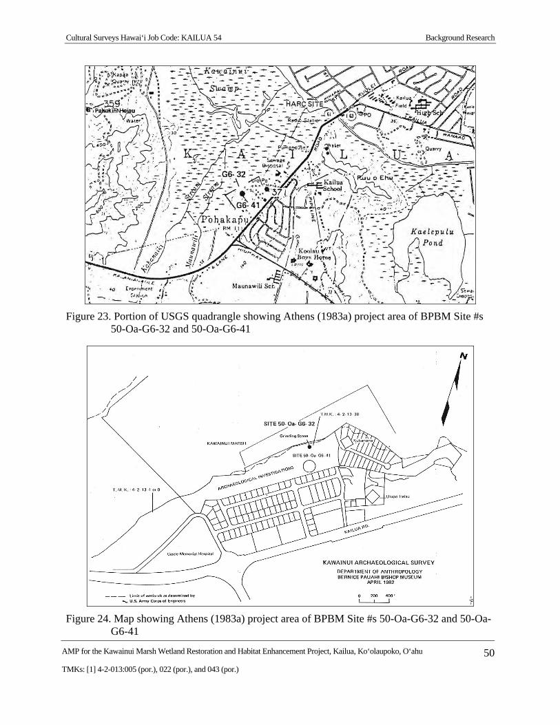
Cultural Surveys Hawai‘i Job Code: KAILUA 54 Background Research
AMP for the Kawainui Marsh Wetland Restoration and Habitat Enhancement Project, Kailua, Ko‘olaupoko, O‘ahu 50
TMKs: [1] 4-2-013:005 (por.), 022 (por.), and 043 (por.)
Figure 23. Portion of USGS quadrangle showing Athens (1983a) project area of BPBM Site #s 50-Oa-G6-32 and 50-Oa-G6-41
Figure 24. Map showing Athens (1983a) project area of BPBM Site #s 50-Oa-G6-32 and 50-Oa-G6-41
Cultural Surveys Hawai‘i Job Code: KAILUA 54 Background Research
AMP for the Kawainui Marsh Wetland Restoration and Habitat Enhancement Project, Kailua, Ko‘olaupoko, O‘ahu 51
TMKs: [1] 4-2-013:005 (por.), 022 (por.), and 043 (por.)
2.3.9 Athens (1983b)
J. Stephen Athens (1983b) documented 11 excavation units in BPBM Site 50-Oa-G6-40, the H.A.R.C. site, located at the northeast end of Kawainui Marsh (see Figure 23 for location) in 1983. The site consisted of marine midden, artifacts, and subsurface features including hearths and pits. Radiocarbon dates indicated occupation of the site sometime in the mid- thirteenth to early fifteenth century. Midden remains were analyzed and conclusions suggest a change through time in the exploitation pattern. Athens suggested use of the Kailua accretion barrier for habitation may have started about the same time as occupation of the site. This site was originally located and excavated by Wheeler (1981). This study demonstrated the potential for significant archaeological deposits within the sandy deposits of the previously disturbed residential neighborhoods along the seaward margin of Kawainui Marsh.
2.3.10 Hammatt et al. (1990)
Hammatt et al. (1990), like Athens and Ward (1991), conducted sediment coring in Kawainui Marsh with the goal of palaeoenvironmental reconstruction. This Hammatt et al. (1990) sediment coring was conducted over a wide area at the north end of the marsh (outside the present study area) and was not associated with any particular site nomenclature. The U.S. Army Corps of Engineers proposed construction of open water channels in the marsh for flood control. There was concern for impacts to archaeological resources within and surrounding the marsh. The objective of the study was to 1) characterize depth, age, and nature of sediments to be impacted in relation to present marsh sediments and 2) reconstruct the environmental history of the marsh to determine the nature and location of Native Hawaiian use including shoreline habitation, fishponds, and agricultural sites. Ten sediment cores were taken from Kawainui Marsh and analyzed for pollen, organic clay mineralogy, stratigraphy, and heavy metals.
The pollen results from this study were particularly notable, especially the finding that Loulu (Pritchardia sp.) palm pollen was by far the most abundant pollen until ca. AD 1410-1650 when the Pritchardia presence collapses and the abundance of grasses (Poaceae) and sedges (Cyperaceae) explodes. Hammat et al. explored the implications for our understanding of Polynesian settlement and the mechanisms of environmental change (Hammatt et al. 1990:54-56).
A preliminary identification of certain macro-botanical finds as possibly Lagenaria sp. gourd (as was reported by Allen-Wheeler 1981:77) lead to a recommendation of further consideration of fruits from marsh muck (Hammatt et al. 1990:56-57).
2.3.11 Athens and Ward (1991)
In 1991, Athens and Ward (1991) carried out an archaeological investigation for a flood control project at the north end of Kawainui Marsh. Thirty-seven core/auger units were excavated along the eastern margin of marsh, in the vicinity of the drainage control levee. The purpose of the investigation was to evaluate the presence or absence of significant archaeological remains in the vicinity. The investigation revealed no archaeological deposits or architectural features. Some possible archaeological sites proved to consist only of levee fill and previously dredged sediment. The palaeoenvironmental investigations of Athens and Ward (1991) were highly successful. These results, coupled with those of Hammatt et al. (1990), did much to broaden our understanding of prehistoric human-induced environmental change in the Hawaiian lowlands.
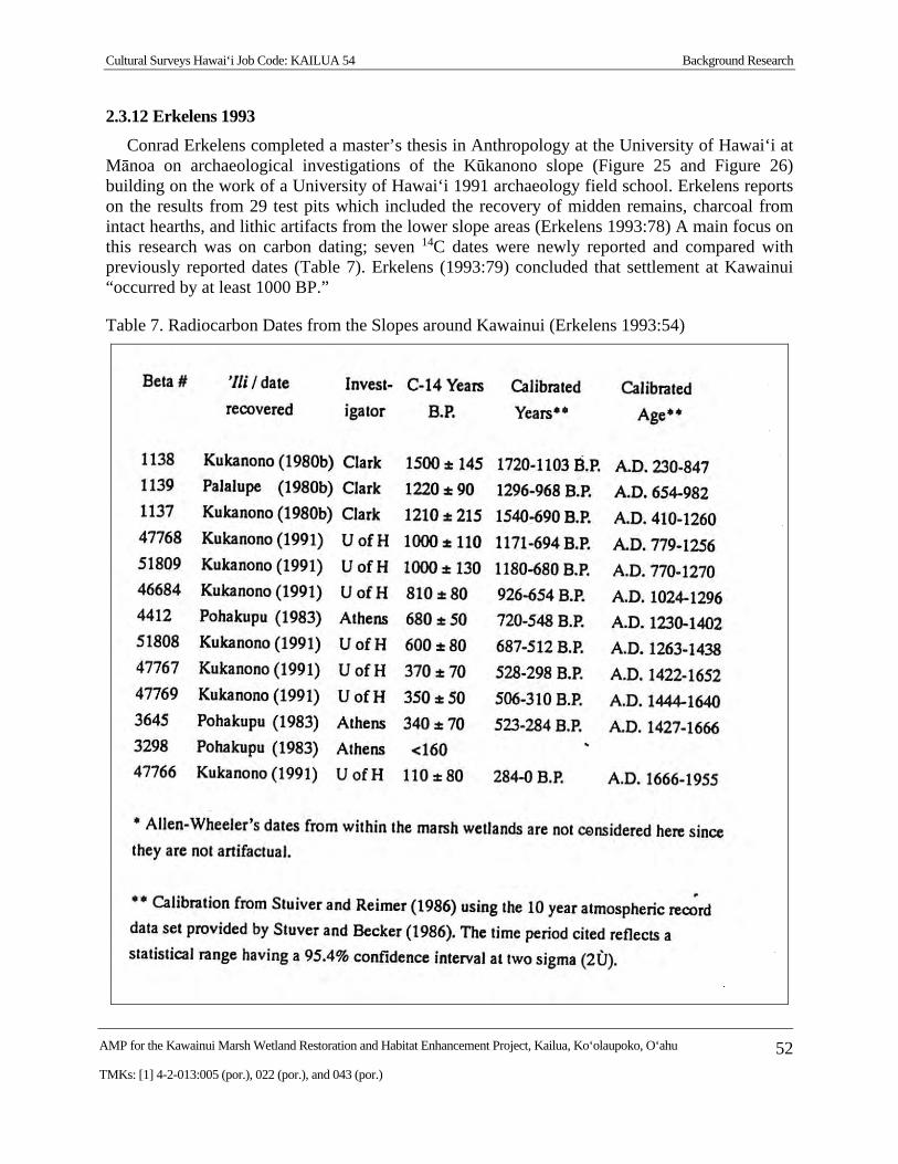
Cultural Surveys Hawai‘i Job Code: KAILUA 54 Background Research
AMP for the Kawainui Marsh Wetland Restoration and Habitat Enhancement Project, Kailua, Ko‘olaupoko, O‘ahu 52
TMKs: [1] 4-2-013:005 (por.), 022 (por.), and 043 (por.)
2.3.12 Erkelens 1993
Conrad Erkelens completed a master’s thesis in Anthropology at the University of Hawai‘i at Mānoa on archaeological investigations of the Kūkanono slope (Figure 25 and Figure 26) building on the work of a University of Hawai‘i 1991 archaeology field school. Erkelens reports on the results from 29 test pits which included the recovery of midden remains, charcoal from intact hearths, and lithic artifacts from the lower slope areas (Erkelens 1993:78) A main focus on this research was on carbon dating; seven 14C dates were newly reported and compared with previously reported dates (Table 7). Erkelens (1993:79) concluded that settlement at Kawainui “occurred by at least 1000 BP.”
Table 7. Radiocarbon Dates from the Slopes around Kawainui (Erkelens 1993:54)
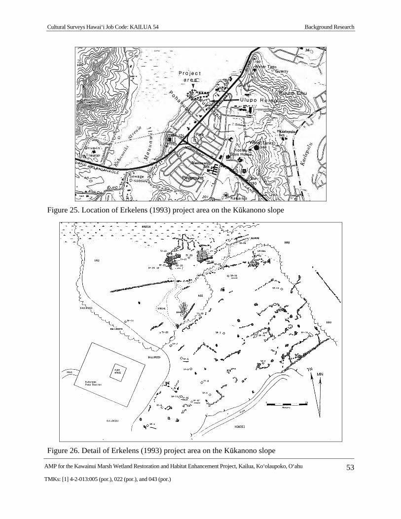
Cultural Surveys Hawai‘i Job Code: KAILUA 54 Background Research
AMP for the Kawainui Marsh Wetland Restoration and Habitat Enhancement Project, Kailua, Ko‘olaupoko, O‘ahu 53
TMKs: [1] 4-2-013:005 (por.), 022 (por.), and 043 (por.)
Figure 25. Location of Erkelens (1993) project area on the Kūkanono slope
Figure 26. Detail of Erkelens (1993) project area on the Kūkanono slope
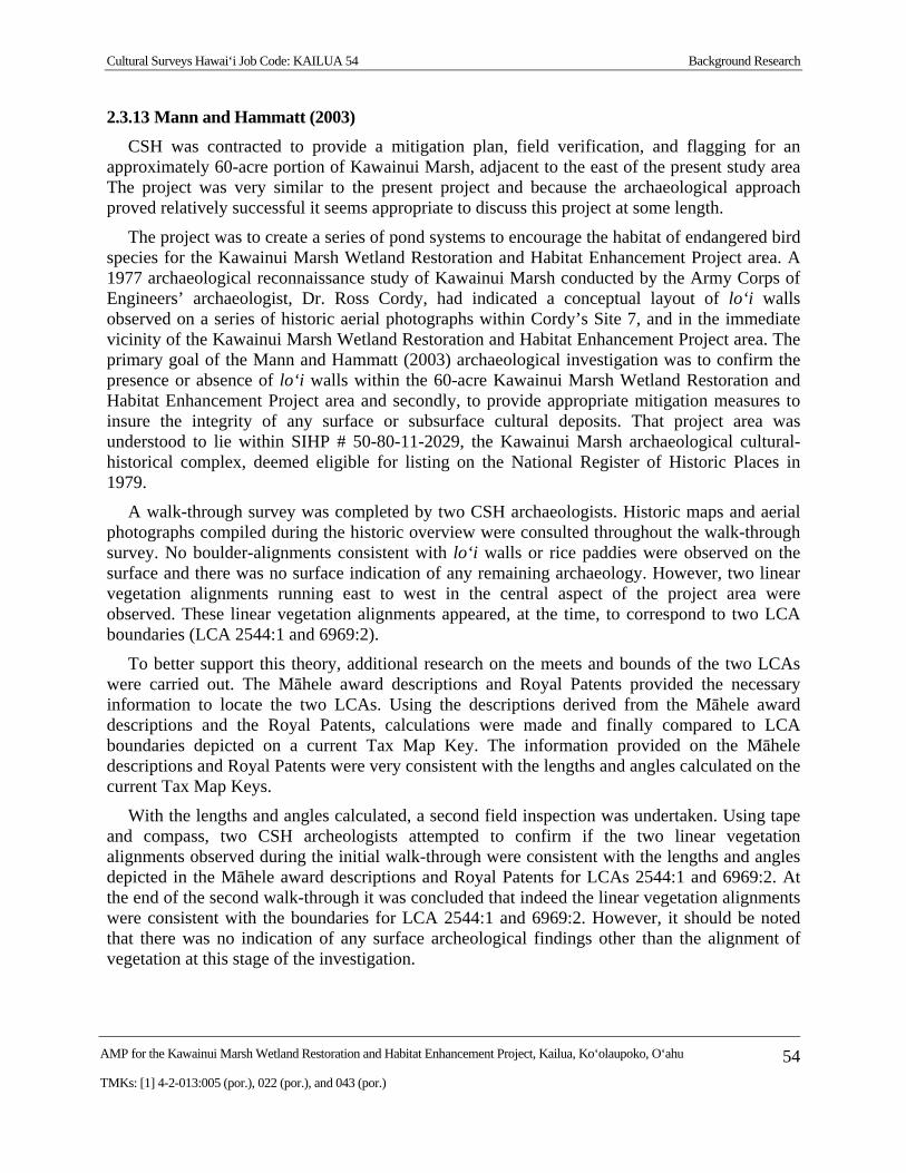
Cultural Surveys Hawai‘i Job Code: KAILUA 54 Background Research
AMP for the Kawainui Marsh Wetland Restoration and Habitat Enhancement Project, Kailua, Ko‘olaupoko, O‘ahu 54
TMKs: [1] 4-2-013:005 (por.), 022 (por.), and 043 (por.)
2.3.13 Mann and Hammatt (2003)
CSH was contracted to provide a mitigation plan, field verification, and flagging for an approximately 60-acre portion of Kawainui Marsh, adjacent to the east of the present study area The project was very similar to the present project and because the archaeological approach proved relatively successful it seems appropriate to discuss this project at some length.
The project was to create a series of pond systems to encourage the habitat of endangered bird species for the Kawainui Marsh Wetland Restoration and Habitat Enhancement Project area. A 1977 archaeological reconnaissance study of Kawainui Marsh conducted by the Army Corps of Engineers’ archaeologist, Dr. Ross Cordy, had indicated a conceptual layout of lo‘i walls observed on a series of historic aerial photographs within Cordy’s Site 7, and in the immediate vicinity of the Kawainui Marsh Wetland Restoration and Habitat Enhancement Project area. The primary goal of the Mann and Hammatt (2003) archaeological investigation was to confirm the presence or absence of lo‘i walls within the 60-acre Kawainui Marsh Wetland Restoration and Habitat Enhancement Project area and secondly, to provide appropriate mitigation measures to insure the integrity of any surface or subsurface cultural deposits. That project area was understood to lie within SIHP # 50-80-11-2029, the Kawainui Marsh archaeological cultural-historical complex, deemed eligible for listing on the National Register of Historic Places in 1979.
A walk-through survey was completed by two CSH archaeologists. Historic maps and aerial photographs compiled during the historic overview were consulted throughout the walk-through survey. No boulder-alignments consistent with lo‘i walls or rice paddies were observed on the surface and there was no surface indication of any remaining archaeology. However, two linear vegetation alignments running east to west in the central aspect of the project area were observed. These linear vegetation alignments appeared, at the time, to correspond to two LCA boundaries (LCA 2544:1 and 6969:2).
To better support this theory, additional research on the meets and bounds of the two LCAs were carried out. The Māhele award descriptions and Royal Patents provided the necessary information to locate the two LCAs. Using the descriptions derived from the Māhele award descriptions and the Royal Patents, calculations were made and finally compared to LCA boundaries depicted on a current Tax Map Key. The information provided on the Māhele descriptions and Royal Patents were very consistent with the lengths and angles calculated on the current Tax Map Keys.
With the lengths and angles calculated, a second field inspection was undertaken. Using tape and compass, two CSH archeologists attempted to confirm if the two linear vegetation alignments observed during the initial walk-through were consistent with the lengths and angles depicted in the Māhele award descriptions and Royal Patents for LCAs 2544:1 and 6969:2. At the end of the second walk-through it was concluded that indeed the linear vegetation alignments were consistent with the boundaries for LCA 2544:1 and 6969:2. However, it should be noted that there was no indication of any surface archeological findings other than the alignment of vegetation at this stage of the investigation.
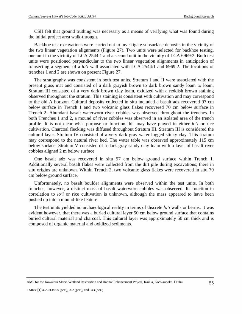
Cultural Surveys Hawai‘i Job Code: KAILUA 54 Background Research
AMP for the Kawainui Marsh Wetland Restoration and Habitat Enhancement Project, Kailua, Ko‘olaupoko, O‘ahu 55
TMKs: [1] 4-2-013:005 (por.), 022 (por.), and 043 (por.)
CSH felt that ground truthing was necessary as a means of verifying what was found during the initial project area walk-through.
Backhoe test excavations were carried out to investigate subsurface deposits in the vicinity of the two linear vegetation alignments (Figure 27). Two units were selected for backhoe testing, one unit in the vicinity of LCA 2544:1 and a second unit in the vicinity of LCA 6969:2. Both test units were positioned perpendicular to the two linear vegetation alignments in anticipation of transecting a segment of a lo‘i wall associated with LCA 2544:1 and 6969:2. The locations of trenches 1 and 2 are shown on present Figure 27.
The stratigraphy was consistent in both test units. Stratum I and II were associated with the present grass mat and consisted of a dark grayish brown to dark brown sandy loam to loam. Stratum III consisted of a very dark brown clay loam, oxidized with a reddish brown staining observed throughout the stratum. This staining is consistent with cultivation and may correspond to the old A horizon. Cultural deposits collected in situ included a basalt adz recovered 97 cm below surface in Trench 1 and two volcanic glass flakes recovered 70 cm below surface in Trench 2. Abundant basalt waterworn river cobbles was observed throughout the trenches. In both Trenches 1 and 2, a mound of river cobbles was observed in an isolated area of the trench profile. It is not clear what purpose or function this may have played in either lo‘i or rice cultivation. Charcoal flecking was diffused throughout Stratum III. Stratum III is considered the cultural layer. Stratum IV consisted of a very dark gray water logged sticky clay. This stratum may correspond to the natural river bed. The water table was observed approximately 115 cm below surface. Stratum V consisted of a dark gray sandy clay loam with a layer of basalt river cobbles aligned 2 m below surface.
One basalt adz was recovered in situ 97 cm below ground surface within Trench 1. Additionally several basalt flakes were collected from the dirt pile during excavations; there in situ origins are unknown. Within Trench 2, two volcanic glass flakes were recovered in situ 70 cm below ground surface.
Unfortunately, no basalt boulder alignments were observed within the test units. In both trenches, however, a distinct mass of basalt waterworn cobbles was observed. Its function in correlation to lo‘i or rice cultivation is unknown, although the mass appeared to have been pushed up into a mound-like feature.
The test units yielded no archaeological reality in terms of discrete lo‘i walls or berms. It was evident however, that there was a buried cultural layer 50 cm below ground surface that contains buried cultural material and charcoal. This cultural layer was approximately 50 cm thick and is composed of organic material and oxidized sediments.
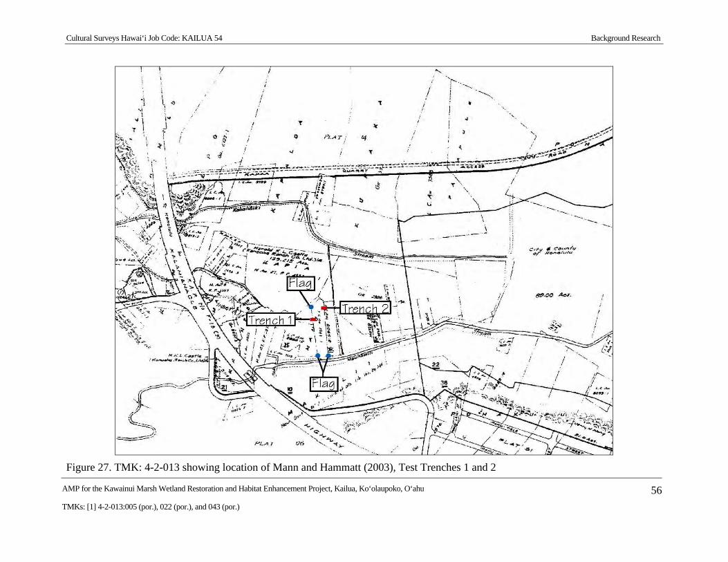
Cultural Surveys Hawai‘i Job Code: KAILUA 54 Background Research
AMP for the Kawainui Marsh Wetland Restoration and Habitat Enhancement Project, Kailua, Ko‘olaupoko, O‘ahu 56
TMKs: [1] 4-2-013:005 (por.), 022 (por.), and 043 (por.)
Figure 27. TMK: 4-2-013 showing location of Mann and Hammatt (2003), Test Trenches 1 and 2
Cultural Surveys Hawai‘i Job Code: KAILUA 54 Background Research
AMP for the Kawainui Marsh Wetland Restoration and Habitat Enhancement Project, Kailua, Ko‘olaupoko, O‘ahu 57
TMKs: [1] 4-2-013:005 (por.), 022 (por.), and 043 (por.)
2.3.14 Hammatt (2013)
Between 2010 and 2011, CSH completed an archaeological reconnaissance survey within the project area (Hammatt 2013). The reconnaissance surface included limited subsurface testing and sediment coring. Limited subsurface testing within the project area identified a sparse amount of historic and traditional Hawaiian artifacts, some of which appear to be linked with habitation within the possible footprint of a house lot that appears on an 1899 map, and considered here to be components of SIHP # 50-80-11-2029. Sediment coring at two locations within Kawainui Marsh provided additional palynological and radiocarbon data. Pollen analysis indicated Kawainui sediments still hold pollen data that can refine and expand our knowledge of Polynesian settlement and pre-Contact change. The reconnaissance survey identified two historic properties within the project area including SIHP # 50-80-11-2029, a Kawainui Marsh archaeological cultural-historical complex, and SIHP # 50-80-11-7199, a road remnant. In consultation with SHPD, an archaeological monitoring program was recommended to mitigate any potential impacts on SIHP # -2029. No further archaeological work was recommended for SIHP # -7199.
Cultural Surveys Hawai‘i Job Code: KAILUA 54 Archaeological Monitoring Provisions
AMP for the Kawainui Marsh Wetland Restoration and Habitat Enhancement Project, Kailua, Ko‘olaupoko, O‘ahu 58
TMKs: [1] 4-2-013:005 (por.), 022 (por.), and 043 (por.)
Section 3 Archaeological Monitoring Provisions
Between 2010 and 2011, CSH completed an archaeological reconnaissance survey within the project area (Hammatt 2013). The reconnaissance survey identified two historic properties within the project area, SIHP # 50-80-11-2029, Kawainui Marsh archaeological cultural-historical complex, and SIHP # 50-80-11-7199, a road remnant. The reconnaissance survey report was accepted by SHPD on 11 April 2013 (LOG NO: 2012.0376/DOC NO: 1303NN01) under the condition that the proposed project proceed under an archaeological monitoring program that will include the condition that data recovery work will occur should any historic properties be encountered (see Appendix A). No further archaeological work was recommended for SIHP # -7199, the road remnant.
Under Hawai‘i State historic preservation legislation, “Archaeological monitoring may be an identification, mitigation, or post-mitigation contingency measure. Monitoring shall entail the archaeological observation of, and possible intervention with, on-going activities, which may adversely affect historic properties” (HAR §13-13-279-3).
Hawai‘i State historic preservation legislation governing archaeological monitoring programs requires that each monitoring plan discuss eight specific items (HAR §13-13-279-4). The monitoring provisions below address these eight requirements in terms of archaeological monitoring for the excavations within the current project area.
1) Anticipated Historic Properties:
The results of the project’s archaeological reconnaissance report indicate there is a potential for additional components of SIHP # 50-80-11-2029, the Kawainui Marsh archaeological cultural-historical complex, to be encountered during clearing and grubbing activities.
2) Locations of Historic Properties:
Historic properties may be encountered anywhere within the project area and may include surface components obscured by dense vegetation or subsurface deposits containing cultural material and/or paleoenvironmental data.
3) Fieldwork:
In consultation with SHPD, the following monitoring methods will be implemented to ensure no adverse impact to any newly-identified historic properties or to SIHP 2029. Upslope of the marsh floor:
(1) The archaeologist will do a surface sweep of each vegetation management area or "pod" with the vegetation contractor prior to initiation of vegetation cutting/removal within the pod;
(2) The archaeologist will identify any areas of potent concern and establish a "caution tape" buffer of at least 10 feet around each area of concern;
(3) The vegetation contractor will ensure that no work or impacts occur within each buffer;
(4) The archaeologist will complete a 100% surface survey of each pod following vegetation cutting/removal; and
Cultural Surveys Hawai‘i Job Code: KAILUA 54 Archaeological Monitoring Provisions
AMP for the Kawainui Marsh Wetland Restoration and Habitat Enhancement Project, Kailua, Ko‘olaupoko, O‘ahu 59
TMKs: [1] 4-2-013:005 (por.), 022 (por.), and 043 (por.)
(5) The archaeologist will document and obtain State Inventory of Historic Places (SIHP) numbers for any historic properties newly identified within each pod.
Ground disturbing work on the marsh floor will be under full-time on-site archaeological monitoring.
Should SHPD request data recovery excavations for any newly-identified historic properties. The field work and results shall meet the requirements of HAR§ 13-278. Data recovery excavations shall be guided by the following research objectives:
Research Objective 1: Refine the timeframe for major vegetation changes(s) within Kawainui Marsh, and
Research Objective 2: Synthesize any newly-identified historic property into a broader spatial, temporal, and functional understanding of the Kawainui Marsh archaeological cultural-historical complex (SIHP # 2029).
Any departure from this will occur only following consultation with and written concurrence from the SHPD.
The monitoring fieldwork may encompass the documentation of surface features and/or subsurface archaeological deposits and will employ current standard archaeological recording techniques. This will include written documentation, plan and profile mapping, stratigraphic documentation, and photography. As appropriate, sampling will include the collection of representative artifacts, bulk sediment samples, and/or sediment cores.
In the event of significant finds, the SHPD will be notified. If human remains are identified, grubbing/clearing activity in the vicinity will be stopped and no exploratory work of any kind will be conducted unless specifically requested by the SHPD. All human skeletal remains encountered during excavation will be handled in compliance with HAR §13-13-300 and HRS §6E-43.
4) Archaeologist’s Role:
The on-site archaeologist will have the authority to stop work immediately in the area of any findings so that documentation can proceed and appropriate treatment can be determined. In addition, the archaeologist will have the authority to slow and/or suspend construction activities in order to ensure the necessary archaeological sampling and recording can take place.
5) Coordination Meeting:
Before work commences on the project, the on-site archaeologist shall hold a coordination meeting to orient the project field crew to the requirements of the archaeological monitoring program. At this meeting the monitor will emphasize his or her authority to temporarily halt construction and state that all finds (including objects such as bottles) are the property of the landowner and may not be removed from the project area.
6) Laboratory Work:
Laboratory work will be conducted in accordance with HAR §13-13-279-5(6). Laboratory analysis of non-burial related finds will be tabulated and standard artifact and midden
Cultural Surveys Hawai‘i Job Code: KAILUA 54 Archaeological Monitoring Provisions
AMP for the Kawainui Marsh Wetland Restoration and Habitat Enhancement Project, Kailua, Ko‘olaupoko, O‘ahu 60
TMKs: [1] 4-2-013:005 (por.), 022 (por.), and 043 (por.)
recording will be conducted. Artifacts will be documented as to provenience, measurements, mass, type of material, and presumed function. Photographs of representative artifacts will be taken for inclusion in the archaeological monitoring report. Bone and shell midden materials will be sorted down to species, when possible, and then tabulated by provenience.
As appropriate, collected charcoal and/or organic sediment potentially containing paleoenviromental data obtained within intact cultural deposits will be sent to Beta Analytic, Inc. for radiocarbon dating and/or PaleoResearch, Inc. for pollen, starch, and/or phytolith analyses. All analyzed samples, provenience information, and results will be presented in table form within the archaeological monitoring report.
7) Report Preparation:
The report will contain sections on monitoring methods, archaeological results, stratigraphy, and results of laboratory analyses, and it will present a synthesis of these results. The report will address the requirements of a monitoring report (pursuant to HAR §13-13-279-5). Photographs of excavations will be included in the monitoring report even if no historically significant sites are documented. Should burial treatment be completed as part of the monitoring effort, a summary of this treatment will be included in the monitoring report. Should burials and/or human remains be identified, then CSH will provide all appropriate additional written documentation (e.g., letters, memos, reports) that may be requested by the SHPD.
8) Archiving Materials:
All burial materials will be addressed in accordance with SHPD directives. Materials not associated with burials will be temporarily stored at CSH’s Waimānalo office until an appropriate curation facility is selected, in consultation with the landowner and the SHPD.
Cultural Surveys Hawai‘i Job Code: KAILUA 54 References Cited
AMP for the Kawainui Marsh Wetland Restoration and Habitat Enhancement Project, Kailua, Ko‘olaupoko, O‘ahu 61
TMKs: [1] 4-2-013:005 (por.), 022 (por.), and 043 (por.)
Section 4 References Cited
Allen-Wheeler, Jane 1981 Archaeological Excavations in Kawai Nui Marsh, Island of O‘ahu. Department of
Anthropology, Bishop Museum, Honolulu.
Alona, Mrs. Charles 1939 Waimanalo-Kailua. Hawaiian Ethnological Notes, 1:1314-1315. Bishop Museum,
Honolulu.
Athens, J. Stephen 1983a Archaeological Excavations on the Pōhākupu-Kūkunono Slope, Kawainui Marsh
O‘ahu. MS 033183. Department of Anthropology, Bishop Museum, Honolulu.
1983b Archaeological Excavations at a Beach Midden Deposit, Kailua, O‘ahu: The H.A.R.C. Site (50-Oa-G6-40). Department of Anthropology, Bishop Museum, Honolulu.
Athens, J. Stephen and Jerome V. Ward 1991 Paleoenvironmental and Archaeological Investigations, Kawai Nui Marsh Flood
Control Project, O‘ahu Island, Hawai‘i. IARI Inc., Honolulu.
Barrera, William M., Jr. 1984 Archaeological Survey for the Kailua Road Interceptor Sewer, Maunawili
Wastewater Pumping Station & Force Main, and Kukanono Wastewater Pump Station & Force Main, Kailua, Oahu. Chiniago, Inc., Kamuela, Hawai‘i.
Beckwith, Martha W. 1970 Hawaiian Mythology. University of Hawaii Press, Honolulu.
Bingham, Hiram 1847 A Residence of Twenty-One Years in the Sandwich Islands; or the Civil,
Religious, and Political History of Those Islands. Hezekiah Huntington, Hartford, Connecticut.
Bordner, Richard M. 1982 Archaeological Reconnaissance of Proposed Kalaheo Sanitary Landfill Site:
Kailua, Oahu, Hawaii (TMK: 4-2-15:1, 6), Appendix C in Revised Environmental Impact Statement for the Proposed Kalaheo Sanitary Landfill). Department of Land and Natural Resources, State Historic Preservation Division, Honolulu.
Brennan, Paul W. 2007a History of Kailua. Presented at the 30 June 2007 signing ceremony of the Kawai
Nui Marsh Bill (HB1899), Honolulu.
Bruner, Phil 2000 Report of an Avifaunal Field Reconnaissance Survey for the Proposed Kawai Nui
Marsh Pathway, Ko‘olaupoko, O‘ahu, Hawai‘i. In Kawai Nui Marsh Pathway Plan by Helber, Hastert and Fee, 2001.
Cultural Surveys Hawai‘i Job Code: KAILUA 54 References Cited
AMP for the Kawainui Marsh Wetland Restoration and Habitat Enhancement Project, Kailua, Ko‘olaupoko, O‘ahu 62
TMKs: [1] 4-2-013:005 (por.), 022 (por.), and 043 (por.)
Bushnell, O.A. 1993 The Gifts of Civilization: Germs and Genocide in Hawaii. University of Hawai‘i
Press, Honolulu.
Chamberlain, Levy 1828 Manuscript Journal of Levy Chamberlain. Typescript in Bernice Pauahi Bishop
Museum Library, Honolulu.
Chun, Malcolm Naea 1987 Ka Moolelo Hawaii Hawaiian Traditions. Davida Malo A New Translation. First
People’s Productions, Honolulu.
Clark, Jeffrey T. 1980 Phase I Archaeological Survey of Castle Estate Lands Around the Kawai Nui
Marsh, Kailua, O‘ahu. Department of Anthropology, Bishop Museum, Honolulu.
Conant, Sheila 1981 A Survey of the Waterbirds of Kawai Nui Marsh. Hawai‘i Department of Planning
and Economic Development, Honolulu.
Cordy, Ross 1977a Cultural Resources Study for the City and County of Honolulu's Permit Request:
Kawainui Marsh Sewerline (Oahu), Archaeological Reconnaissance and Pre-1850 Literature Search. U.S. Army Corps of Engineers, Pacific Ocean Division, Honolulu.
1977b Kāne‘ohe Bay Urban Water Resources Study. Cultural Resources Planning, U.S. Corps of Engineers, Pacific Division, Honolulu.
1978 Test Excavations: Site 7, Kawai Nui Marsh, Kailua Ahupua‘a, O‘ahu and Determination of Effect. U.S. Army Corps of Engineers, Honolulu.
Coulter, John Wesley and Chee Kwon Chun 1937 Chinese Rice Farmers in Hawaii. UH Research Publications, Number 16.
University of Hawai‘i at Mānoa, Honolulu.
Covington, Richard 1881 Hawaiian Government Survey Map. Registered Map 1381. Available at the
Department of Accounting and General Services, Land Survey Division, 1151 Punchbowl Street, Room 210, Honolulu.
Creed, Victoria S. and Rodney Chiogioji 1991 Facets of Maunawili Valley and Kailua Ahupua‘a History in Conjunction with
Named Places in the Ahupua‘a of Kailua with Special Emphasis on Maunawili Valley: An Index with Anecdotes, sources and further Information and Photos and Documents. Cultural Surveys Hawai‘i, Inc., Kailua, Hawai‘i.
DHM Planners, Inc. 1990 Women's Community Correctional Center, Draft Environmental Impact
Statement, D.A.G.S. Job No.12-27-2357, Olomana, Kailua, Oahu, Hawaii. DHM Planners, Honolulu.
Cultural Surveys Hawai‘i Job Code: KAILUA 54 References Cited
AMP for the Kawainui Marsh Wetland Restoration and Habitat Enhancement Project, Kailua, Ko‘olaupoko, O‘ahu 63
TMKs: [1] 4-2-013:005 (por.), 022 (por.), and 043 (por.)
Drigot, Diane C. 1982 Ho‘ona‘auao No Kawai Nui (Educating About Kawai Nui). University of Hawai‘i
at Mānoa, Honolulu.
Dye, Thomas S. 1979a Archaeological Phase I Survey and Test Excavations, Site 50-Oa-G6-31, Ko‘olau
Poko, O‘ahu. Anthropology Department, Bishop Museum, Honolulu.
1979b Archaeological Reconnaissance Survey of Site of Proposed Phase II Kapa‘a Quarry, Ulumawao Ridge, Kapa‘a, Ko‘olaupoko, O‘ahu, Appendix 4 in Environmental Impact Statement for the Proposed Kapaa Quarry Phase II Project. Anthropology Department, Bishop Museum, Honolulu.
Engilis, A. 1988 Waterbird Status in Kawai Nui Marsh, State of Hawaii Department of Land and
Natural Resources. Department of Land and Natural Resources, Division of Forestry and Wildlife, Honolulu.
Erkelens, Conrad 1993 The Archaeological Investigation of the Kukanono Slope, Kawai Nui Marsh,
Kailua, Ko‘olaupoko, O‘ahu. Master’s thesis, Department of Anthropology, University of Hawai‘i at Mānoa, Honolulu.
Ewart, Ned D. and Myra T. Tuggle 1977 Archaeological Investigation Kawainui Swamp Ko‘olaupoko, Kailua, O‘ahu
Island. Ms. 14-94. Archaeological Research Center of Hawaii, Inc., Lawa‘i, Kaua‘i, Hawai‘i.
Foote, Donald E., Elmer L. Hill, Sakuichi Nakamura, and Floyd Stephens 1972 Soil Survey of the Islands of Kauai, Oahu, Maui, Molokai, and Lanai, State of
Hawaii. U.S. Department of Agriculture, Soil Conservation Service, in cooperation with the University of Hawai‘i Agricultural Experiment Station. U.S. Government Printing Office, Washington, D.C.
Fornander, Abraham 1917-1918 Collection of Hawaiian Antiquities and Folklore. T.G. Thrum, editor.
Memoirs of the Bernice Pauahi Bishop Museum (Vol. V). Bishop Museum Press, Honolulu.
Hall, W. Thos 1997 The History of Kailua. Thos. Hall, Kailua, Hawai‘i.
Hammatt, Hallett H. 2013 Archaeological Reconnaissance Survey with Limited Subsurface Testing in
Support of the Kawainui Marsh Wetland Restoration and Habitat Enhancement Project, Kailua Ahupua‘a, Ko‘olaupoko District, O‘ahu TMK: [1] 4-2-013: 005 por., 022 por. and 043 por. Cultural Surveys Hawai‘i, Inc., Kailua, Hawai‘i.
Hammatt, Hallett H. and David W. Shideler 1990 Archaeological Reconnaissance for the Castle Junction Interchange Project,
Kailua and Kāne‘ohe, Ko‘olaupoko, O‘ahu. Cultural Surveys Hawai‘i, Inc., Kailua, Hawai‘i.
Cultural Surveys Hawai‘i Job Code: KAILUA 54 References Cited
AMP for the Kawainui Marsh Wetland Restoration and Habitat Enhancement Project, Kailua, Ko‘olaupoko, O‘ahu 64
TMKs: [1] 4-2-013:005 (por.), 022 (por.), and 043 (por.)
Hammatt, Hallett H., Victoria S. Creed, and Matthew McDermott 1999 Archaeological Inventory Survey of Kailua 272 Reservoir and Access Road
Kailua, Ahupua‘a of Kailua, Island of O‘ahu (TMK: 4-2-03:04, 08 & 4-2-04:37). Cultural Surveys Hawai‘i, Inc., Kailua, Hawai‘i.
Hammatt, Hallett H., David W. Shideler, Rodney Chiogioji, and Randy Scoville 1990 Sediment Coring in Kawai Nui Marsh, Kailua, O‘ahu, Ko‘olaupoko. Cultural
Surveys Hawai‘i, Inc., Kailua, Hawai‘i.
Handy, E.S. Craighill 1940 The Hawaiian Planter. Bishop Museum Bulletin Volume 1, No. 161. Bernice
Pauahi Bishop Museum, Honolulu.
Handy, E.S. Craighill and Elizabeth G. Handy 1972 Native Planters in Old Hawaii: Their Life, Lore, and Environment. Bishop
Museum Bulletin 233. Bishop Museum Press, Honolulu.
Harland, Bartholomew and Associates 1959 A General Plan for Waimanalo Valley, Island of O‘ahu, Territory of Hawaii.
Harland, Batholomew and Associates, Honolulu.
Hawai‘i TMK Service 2014 Tax Map Key [1] 4-2-013. Available at Hawai‘i TMK Service, 222 Vineyard
Street, Suite 401, Honolulu.
Kailua Historical Society 2009 Kailua: In the Wisps of the Malanai Breeze. Kailua Historical Society, Kailua,
Hawai‘i.
Kamakau, Samuel Manaiakalani 1875 Article in Hawaiian language newspaper, Ku‘oko‘a, published 27 November.
Ke Au Hou 1911 Huakai Makaikai I na Wahi Pana o Kini Kailua, Ke Au Hou, 9 August.
Kelly, Marion and Jeffrey T. Clark 1980 Kawainui Marsh, O‘ahu: Historical and Archaeological Studies, Bishop Museum
Departmental Report Series 80-3. Bishop Museum Anthropology Department. Bishop Museum Press, Honolulu.
Kelly, Marion and Barry Nakamura 1981 Historical Study of Kawai Nui Marsh Area, Island of O‘ahu. Bernice Pauahi
Bishop Museum, Honolulu.
Kuykendall, Ralph S. 1980 The Hawaiian Kingdom, Vol.1. University of Hawai‘i Press, Honolulu.
M&E Pacific, Inc. 1990 Kawai Nui Marsh Flood Damage Mitigation Project, Final Environmental Impact
Statement. M&E Pacific, Inc., Honolulu.
Macdonald, G.A. and A.T. Abbott 1974 Volcanoes in the Sea. University of Hawai‘i Press, Honolulu.
Cultural Surveys Hawai‘i Job Code: KAILUA 54 References Cited
AMP for the Kawainui Marsh Wetland Restoration and Habitat Enhancement Project, Kailua, Ko‘olaupoko, O‘ahu 65
TMKs: [1] 4-2-013:005 (por.), 022 (por.), and 043 (por.)
Malo, David 2006 Ka Mo‘olelo Hawai‘i. Hawaiian Traditions. Malcom Nāea Chun, translator. First
People’s Productions, Honolulu.
Mann, Melanie M. and Hallett H. Hammatt 2003 Kawai Nui Marsh Environmental Restoration Project, Mitigation Plan & Field
Verification & Flagging, Kailua Ahupua‘a, Ko‘olaupoko District, Island of O‘ahu TMK: 4-2-13. Cultural Surveys Hawai‘i, Inc., Kailua, Hawai‘i.
Mann, Melanie M., Matthew McDermott, and Hallett H. Hammatt 2001 Archaeological Assessment of the Proposed Kawai Nui Gateway Park, Ahupua‘a
of Kailua, District of Ko‘olaupoko, Island of O‘ahu (TMK: 4-2-16: por. 1; 4-2-17: por. 20; 4-4-34:25, 37). Cultural Surveys Hawai‘i, Inc., Kailua, Hawai‘i.
McAllister, J.G. 1933 Archaeology of O‘ahu. Bishop Museum Bulletin 104. Bernice Pauahi Bishop
Museum, Honolulu.
McDermott, Matthew, Kristina W. Bushnell, Victoria S. Creed, Scott T. Kikiloi, and Hallett H. Hammatt
2000 Archaeological Assessment and Background Literature Search for the Proposed Circle-Kawai Nui Marsh Trail Project, Kailua Ahupua‘a, District of Ko‘olaupoko, Island of O‘ahu. Cultural Surveys Hawai‘i, Inc., Kailua, Hawai‘i.
Medeiros, Colleen P., Anthony R. Bush, and Hallett H. Hammatt 2000 Archaeological Monitoring Report for the Former Andy's Drive-Inn, Kailua,
Ko‘olaupoko, O‘ahu, Hawai‘i (TMK: 4-3-53:29). Cultural Surveys Hawai‘i, Inc., Kailua, Hawai‘i.
Neller, Earl 1982 Archaeological Investigations at Kawai Nui Marsh, in the Kukanono Area,
Kailua, O‘ahu, TMK 4-2-13:38. Department of Land and Natural Resources, State Historic Preservation Division, Honolulu.
Paki, Pihilani 1976 Oral history communication to Muriel Seto. Kailua, Hawai‘i.
Pantaleo, Jeffrey and Paul L. Cleghorn 1989 Reconnaissance Survey of the Proposed Windward Park, Kailua, O‘ahu Island
(TMK 4-2-14:2 and 4). Applied Research Group, Bishop Museum, Honolulu.
Pukui, Mary Kawena 1983 ‘Ōlelo No‘eau: Hawaiian Proverbs and Poetical Sayings. Bishop Museum
Special Publication No.71. Bishop Museum Press, Honolulu.
Pukui, Mary K. and Samuel H. Elbert 1986 Hawaiian Dictionary. Second edition. University of Hawai‘i Press, Honolulu.
Pukui, Mary K., Samuel H. Elbert, and Esther Mookini 1974 Place Names of Hawaii. University of Hawai‘i Press, Honolulu.
Quebral, Rey F., Carolyn J. Orndoff, and J. Stephen Athens 1991 Archaeological Inventory Survey, Phase I, Kailua Gateway Development, Kailua,
O‘ahu, Hawai‘i. International Archaeological Research Institute, Inc., Honolulu.
Cultural Surveys Hawai‘i Job Code: KAILUA 54 References Cited
AMP for the Kawainui Marsh Wetland Restoration and Habitat Enhancement Project, Kailua, Ko‘olaupoko, O‘ahu 66
TMKs: [1] 4-2-013:005 (por.), 022 (por.), and 043 (por.)
Saturday Press 1883 Dictionary of Hawaiian Localities. Saturday Press, 25 August.
Schmitt, Robert C. 1968 Demographic Statistics of Hawaii: 1778-1965. University of Hawai‘i Press,
Honolulu.
Shallengerger, R.J. 1977 An Ornithological Survey of Hawaiian Wetlands, Volume II. Ahuimanu
Productions, Honolulu.
Snow, Charles E. 1974 Early Hawaiians: An Initial Study of Skeletal Remains from Mokapu, Oahu.
University Press of Kentucky, Lexington, Kentucky.
Stannard, David E. 1989 Before the Horror. University of Hawai‘i Press, Honolulu.
State of Hawai‘i 1997 Ulupo State Monument., Kailua, O‘ahu. State of Hawai‘i, Department of Land
and Natural Resources. Electronic document, http://www.hawaiistateparks.org/parks/ brochure_pdfs/hsp_ulupo_heiau_state_monument24.pdf (accessed 27 May 2008).
Sterling, Elspeth P. and Catherine C. Summers 1978 Sites of O‘ahu. Department of Anthropology, Bernice Pauahi Bishop Museum,
Honolulu.
Summers, Catherine C. 1964 Hawaiian Fishponds. Bishop Museum Special Publication No. 52. Bishop
Museum Press, Honolulu.
Thrum, Thomas G. 1907 Hawaiian Almanac and Annual for 1908. Thomas G. Thrum, Honolulu.
1909 Hawaiian Almanac and Annual for 1910. Thomas G. Thrum, Honolulu.
1916 Hawaiian Almanac and Annual for 1917. Thomas G. Thrum, Honolulu.
Toulouse, Julian Harrison 1971 Bottle Makers and Their Marks. Blackburn Press, Caldwell, New Jersey.
Tulchin, Jon and Hallett H. Hammatt 2010 Archaeological Literature Review and Sensitivity Zone Map for the Hawaiian
Electric Big Wind Interconnection O‘ahu East Shore Project, Kāne‘ohe and Kailua Ahupua‘a, Ko‘olaupoko District, O‘ahu Island. Cultural Surveys Hawai‘i, Inc., Kailua, Hawai‘i.
U.S. Army Map Service 1952 U.S. Army Map Service Map, Mokapu Quadrangle. Available at USGS
Information Services, Box 25286, Denver, Colorado.
U.S. Army War Department 1919 U.S. Army War Department Fire Control Map, Waimanalo Quadrangle. Available
at USGS Information Services, Box 25286, Denver, Colorado.
Cultural Surveys Hawai‘i Job Code: KAILUA 54 References Cited
AMP for the Kawainui Marsh Wetland Restoration and Habitat Enhancement Project, Kailua, Ko‘olaupoko, O‘ahu 67
TMKs: [1] 4-2-013:005 (por.), 022 (por.), and 043 (por.)
1943 U.S. Army War Department Map, Kaneohe Quadrangle. Available at USGS Information Services, Box 25286, Denver, Colorado.
U.S. Department of Agriculture 2001 Soil Survey Geographic (SSURGO) database. U.S. Department of Agriculture.
Natural Resources Conservation Service. Fort Worth, Texas. http://www.ncgc.nrcs.usda.gov/products/datasets/ssurgo/.
U.S. Fish and Wildlife Service 1991 Fish and Wildlife Coordination Act Report Kawai Nui Marsh Flood Control
Project. U.S. Fish and Wildlife Service Pacific Islands Office, Honolulu.
U.S. Geological Survey 1928 Mokapu USGS 7.5-minute series topographic quadrangle. Available at USGS
Information Services, Box 25286, Denver, Colorado.
1998 Mokapu Point USGS 7.5-minute series topographic quadrangle. Available at USGS Information Services, Box 25286, Denver, Colorado.
2005 Orthoimagery aerial photograph. Available at USGS Information Services, Box 25286, Denver, Colorado.
Valeri, Valerio 1985 Kinship and Sacrifice: Ritual and Society in Ancient Hawaii. University of
Chicago Press, Chicago and London.
Wall, W.E. 1899 Hawaii Territory Survey map. Available at Hawai‘i Land Survey Division,
Department of Accounting and General Services, 1151 Punchbowl Street, Room 210, Honolulu.
1902 Hawaii Territory Survey map. Registered map 2374. Available at Hawai‘i Land Survey Division, Department of Accounting and General Services, 1151 Punchbowl Street, Room 210, Honolulu.
Waihona ‘Aina 2000 The Māhele Database. Electronic document, http://waihona.com.
Watanabe, Farley K. 1988 Memorandum for the Record: Archaeological Monitoring of Kawainui Marsh
Levee and Appurtenant Dredging and Vegetation Removal Operations, Kailua, Ko‘olaupoko District, O‘ahu Island. U.S. Army Corps of Engineers, Honolulu.
Whitman, Katherine and Hallett H. Hammatt 2008 An Archaeological Monitoring Report for the Kailuana Place and Kailuana Loop
Sewer Replacement/Rehabilitation Project (W4-06), Kailua Ahupua‘a, Ko‘olaupoko District, O‘ahu Island TMK [1] 4-03-022 & 083. Cultural Surveys Hawai‘i, Inc., Kailua, Hawai‘i.
Wilcox, Carol 1996 Sugar Water: Hawaii’s Plantation Ditches. University of Hawai‘i Press,
Honolulu.
Cultural Surveys Hawai‘i Job Code: KAILUA 54 References Cited
AMP for the Kawainui Marsh Wetland Restoration and Habitat Enhancement Project, Kailua, Ko‘olaupoko, O‘ahu 68
TMKs: [1] 4-2-013:005 (por.), 022 (por.), and 043 (por.)
Wyllie, R.C. 1848 Answers to Questions Proposed by His Excellency, R.C. Wyllie, His Hawaiian
Majesty’s Minister of Foreign Relations, and Addressed to all the Missionaries in the Hawaiian Islands, May 1846. Hawaii Government, Honolulu.
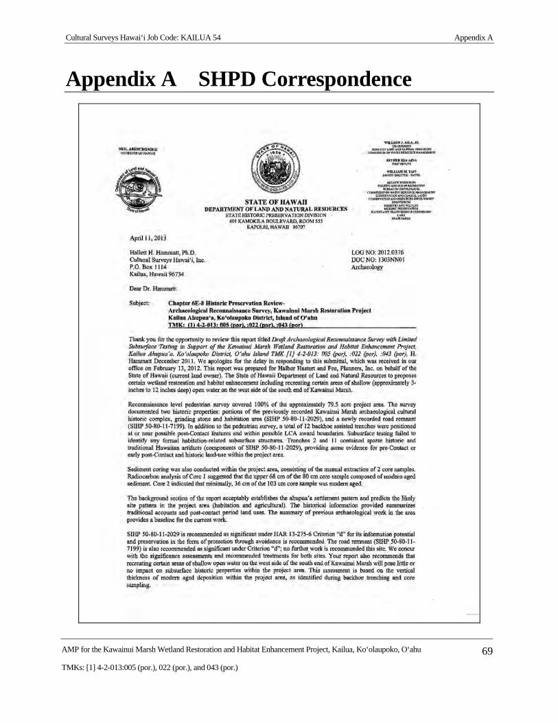
Cultural Surveys Hawai‘i Job Code: KAILUA 54 Appendix A
AMP for the Kawainui Marsh Wetland Restoration and Habitat Enhancement Project, Kailua, Ko‘olaupoko, O‘ahu 69
TMKs: [1] 4-2-013:005 (por.), 022 (por.), and 043 (por.)
Appendix A SHPD Correspondence
Cultural Surveys Hawai‘i Job Code: KAILUA 54 Appendix A
AMP for the Kawainui Marsh Wetland Restoration and Habitat Enhancement Project, Kailua, Ko‘olaupoko, O‘ahu 70
TMKs: [1] 4-2-013:005 (por.), 022 (por.), and 043 (por.)