Embed Size (px)
Citation preview
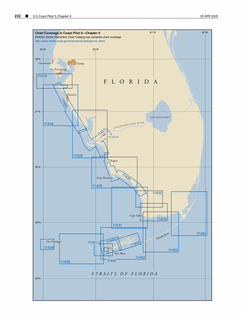
232 ¢ U.S. Coast Pilot 5, Chapter 4 05 APR 2020
11438
11447
1144611445
1143911442
11452
11431
11430
11427
11425
11433
11426
11424
Fort Myers
Sarasota
Tampa
Cape Sable
Cape Romano
Dry Tortugas
28°N
27°N
26°N
25°N
24°N
83°W 82°W
81°W 80°W
Naples
Florida Keys
C A L O O S A H A T C H E E R I V E R
St. Petersburg
11415
Chart Coverage in Coast Pilot 5—Chapter 4NOAA’s Online Interactive Chart Catalog has complete chart coveragehttp://www.charts.noaa.gov/InteractiveCatalog/nrnc.shtml
S T R A I T S O F F L O R I D A
F L O R I D A
LAKE OKEECHOBEE
Clearwater
Key West
11429
11432
11441
11462
05 APR 2020 U.S. Coast Pilot 5, Chapter 4 ¢ 233
Key West to Tampa Bay
(1) This chapter describes the west coast of Florida from Key West to Tampa Bay; the ports of Key West, Naples, Fort Myers, Port Boca Grande, Venice and Sarasota; and many of the smaller ports and landings. Also described are the Ten Thousand Islands, Big Marco Pass, Gordon Pass, Estero Island, Matanzas Pass, San Carlos Bay, Caloosahatchee River, Sanibel Island, Charlotte Harbor, Peace River, Myakka River, Gasparilla Sound, Gasparilla Island, New Pass, Venice Inlet, Big Sarasota Pass, Lido Key, Longboat Key, Longboat Pass and Anna Maria Key.
(2) The section of the Intracoastal Waterway from Caloosahatchee River, FL, to Tampa Bay passing through the waters described in this chapter and places along its route is discussed in Chapter 12.
(3) COLREGS Demarcation Lines
(4) The lines established for this part of the coast are described in 33 CFR 80.740 through 80.750, Chapter 2.
(5) ENC - US3GC07M Chart - 11420
(6) The coast, for nearly 115 miles, from Key West to San Carlos Bay, is low, sandy and generally wooded. Innumerable small islands and keys, interlaced by many small rivers and bayous, make up Everglades National Park and the Ten Thousand Islands. From San Carlos Bay north to Tampa Bay the coast is made up of nearly straight sandy beaches of the barrier islands.
Florida Keys Particularly Sensitive Sea Area (PSSA)The Florida Keys Particularly Sensitive Sea Area (PSSA) is a zone designated by the International Maritime
Organization that encircles the sea area around all of the Florida Keys. The PSSA includes the entire Florida Keys National Marine Sanctuary as well as Biscayne National Park at the northeastern end of the keys. The PSSA has been established to protect the exceptional values of the sea area around the Florida Keys from possible damage by international shipping activities. The PSSA includes the Tortugas Ecological Reserve, which was established in 2001 to protect nearly pristine coral formations and habitat in the Sanctuary. The coral resources within the Reserve are especially vulnerable to possible damage from shipping activities.
Domestic law and regulations adopted by the United States for the Sanctuary apply within the PSSA. Several of these concern shipping activities.
Areas to be Avoided (ATBAs)–There are four ATBAs in the Sanctuary: in the vicinity of the Florida Keys, in the vicinity of Key West Harbor, in an area surrounding the Marquesas Islands, and in an area surrounding the Dry Tortugas Islands. All tank vessels and vessels greater than 50 meters in registered length are prohibited from operating within the ATBAs. The ATBAs are described and the coordinates are provided in Chapter 3.
Areas Closed to Anchoring–All vessels are prohibited from anchoring in the Tortugas Ecological Reserve. Vessels that are 100 feet or less in length (30.48 meters) may request permission from the Sanctuary to use mooring buoys in the northern portion of the Reserve (Tortugas North). Vessels 50 meters or greater in registered length are prohibited from anchoring on the portion of Tortugas Bank west of Dry Tortugas National Park. (This area was modifi ed in January 2001 by the establishment of the Tortugas Ecological Reserve.)
Anchoring Restriction–In areas of the Sanctuary identifi ed as Ecological Reserves and Sanctuary Preservation Areas all anchor apparatus (including the anchor, chain or rope) must not touch any coral, living or dead, or any attached organism. In all other areas of the Sanctuary, vessels are prohibited from anchoring on living coral in water depths of less than 40 feet when visibility is such that the seabed can be seen.
Restricted Access–Vessels are not allowed to stop in the southern portion of the Tortugas Ecological Reserve (Tortugas South) and must receive permission in advance in order to stop in the northern portion of the Reserve (Tortugas North).
Discharge Restriction–In Ecological Reserves and Sanctuary Preservation Areas, all discharges and deposits are prohibited except cooling water or engine exhaust.
Additional restrictions on vessel activities, such as vessel discharges, apply within the Sanctuary. (See 15 CFR 922, chapter 2, for limits and regulations) for the Sanctuary, including the coordinates of ATBAs, Ecological Reserves and Sanctuary Preservation Areas.
(11)
234 ¢ U.S. Coast Pilot 5, Chapter 4 05 APR 2020
(7) The Florida Keys comprise a chain of low islands along the southwest coast of the Florida Peninsula extending west in a wide arc to the Dry Tortugas. The keys are mostly of coral formation and are generally covered with dense mangrove, though some have stands of pine and a few have coconut groves. Florida Keys National Marine Sanctuary, a Marine Protected Area (MPA), surrounds the keys from Biscayne Bay to Dry Tortugas.
(8) On the straits side of the keys, and at an average distance of 5 miles, are the Florida Reefs, a dangerous line of shoals extending along the entire length of the chain. The reefs are particularly hazardous because they do not break in smooth weather and few of them are exposed. The water shoals abruptly between the reefs and along their outer edges.
(9) When approaching the reefs from seaward, their proximity usually is indicated by a change in color of the water from deep blue to light green or by the bank blink, described in chapter 3. However, too much reliance should not be placed on such indications. Lights and daybeacons facilitate navigation along the reefs in clear weather, but soundings should be resorted to in thick weather. Depths of 50 fathoms indicate a distance of 2 to 3 miles from the reefs, and great caution should be used in approaching closer. Fogs are infrequent in this area.
(10) The water always becomes milky following windy weather. The usual color is bluish green on the reefs, while the rock patches are dark, shading through brown to yellow as they approach the surface. Sand patches are bright green. Grass patches at depths of 10 to 15 feet have the appearance of rocks. With the sun astern, the line marking deep water and the edges of reefs is surprisingly clear from a position aloft.
(12) Weather
(13) Along the coast from Key West to Tampa Bay, the major weather hazards include tropical cyclones, thunderstorms and cold fronts. Tropical cyclones, which can occur in any month, are mainly a threat in June, August, September and October. Seventeen tropical cyclones have approached the coastline between Key West and Tampa Bay since 1950. The chance of a tropical cyclone encounter decreases along the west coast, north to Fort Myers and Tampa Bay. Thunderstorms develop on about 60 to 80 days annually along this section of the coast. They are least likely near Key West and most likely in the Tampa Bay area. While they can occur at any time, they are most likely from June through September, during the late afternoon and evening hours; at sea they frequently occur at night. During the summer months, thunderstorms are observed on about 10 to 20 days per month. From fall through spring, cold fronts occasionally reach these waters, generating strong, gusty winds that kick up rough seas. While gales are infrequent, winds of 28 knots or more occur about 1 to 2 percent of the time off Key West and 2 to 3 percent of the time off Fort Myers. Wave heights of 10 feet or more are encountered 1 to 3 percent of the time in the south compared to 3 to 5 percent off Fort Myers. Visibilities are usually good, particularly off Key West. Farther north, they drop below 2 miles about 1 percent of the time from December through April. Along the coast, a shallow ground fog may form, but this usually dissipates with the rising sun.
(15) ENCs - US5FL94M, US5FL93M, US5FL99M Charts - 11447, 11441, 11446
(16) Key West Harbor is 134 miles and 151 miles southwest of Miami Harbor via the inside and coastwise
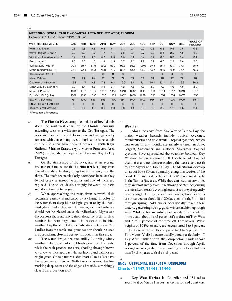
(14)
METEOROLOGICAL TABLE – COASTAL AREA OFF KEY WEST, FLORIDABetween 23°N to 25°N and 79°W to 83°W
WEATHER ELEMENTS JAN FEB MAR APR MAY JUN JUL AUG SEP OCT NOV DECYEARS OF RECORD
Wind > 33 knots ¹ 0.5 0.5 0.3 0.2 0.1 0.3 0.1 0.2 0.5 0.6 0.5 0.5 0.3 Wave Height > 9 feet ¹ 2.0 2.0 1.9 1.7 1.1 0.8 0.4 0.7 0.7 2.4 2.5 1.9 1.5 Visibility < 2 nautical miles ¹ 0.4 0.4 0.3 0.2 0.3 0.5 0.2 0.4 0.4 0.7 0.3 0.4 0.4 Precipitation ¹ 2.8 2.6 1.8 1.4 2.5 3.7 2.3 2.9 3.9 4.6 2.9 2.6 2.8 Temperature > 69° F 70.1 69.7 81.9 95.2 99.7 99.9 99.9 100.0 99.9 99.3 93.3 77.1 90.9 Mean Temperature (°F) 72.2 72.4 74.3 76.8 79.7 82.8 83.7 84.0 83.2 80.5 76.9 73.5 78.5 Temperature < 33° F ¹ 0 0 0 0 0 0 0 0 0 0 0 0 0 Mean RH (%) 78 78 78 77 78 79 77 77 79 78 77 77 78 Overcast or Obscured ¹ 12.8 11.7 9.8 7.2 9.4 12.9 6.8 7.1 10.1 12.4 10.4 12.3 10.2 Mean Cloud Cover (8ths) 3.8 3.7 3.5 3.4 3.7 4.2 4.0 4.0 4.3 4.3 4.0 4.0 3.9 Mean SLP (mbs) 1019 1018 1017 1017 1015 1016 1017 1016 1014 1014 1017 1019 1017 Ext. Max. SLP (mbs) 1038 1036 1035 1035 1031 1032 1030 1029 1030 1031 1034 1037 1038 Ext. Min. SLP (mbs) 997 1000 997 998 1000 997 1004 1002 996 991 1000 1000 991 Prevailing Wind Direction E E E E E E E E E E E E E Thunder and Lightning ¹ 0.5 0.7 0.5 0.6 2.0 3.0 4.8 5.0 5.9 3.2 1.2 0.6 2.4
¹ Percentage Frequency
05 APR 2020 U.S. Coast Pilot 5, Chapter 4 ¢ 235
routes, respectively. The harbor proper is in front of the city of Key West, protected on the east side by the island and on the opposite side by Tank Island and Wisteria Island, reefs and sand flats. The harbor is entered through breaks in the reef by several principal channels with depths of about 13 to 33 feet and several minor channels.
(17) Key West, on the island of the same name near the west end of the Florida Keys, is a winter resort. Tourism is one of the leading industries. Cruise ships frequently call here, and the harbor is a safe haven for any vessel.
(18) Prominent features
(19) Easy to identify when standing along the keys are three 300-foot-high radio towers and a watertank about 0.3 mile east-southeast of Fort Taylor, the hotel 0.3 mile south of Key West Bight, the cupola close south of the hotel, a white spherical radar dome, and a 110-foot-high abandoned lighthouse 0.5 mile east-northeast of Fort Taylor. Numerous tanks, lookout towers, and masts are prominent but difficult to identify. Also conspicuous are a white radar dome and an aerobeacon on Boca Chica Key, and the aerobeacon at Key West International Airport. From south, several apartment complexes, condominiums and hotels on the south shore just west of the airport are prominent.
(20) Sand Key Light (24°27'21"N., 81°52'38"W.), 40
feet above the water, is shown from a white, square pyramidal skeleton tower (abandoned) enclosing a stair cylinder and square dwelling.
(21) Channels
(22) Main Ship Channel is the only deep-draft approach to Key West. Federal project depth is 34 feet from the Straits of Florida to a turning basin off the Naval Air Station Truman Annex Mole and inside the annex basin, thence 30 feet to an upper turning basin off Key West Bight, and then 12 feet to and including a turning basin in the bight. (See Notice to Mariners and latest editions of the charts for controlling depths.) The channel from the entrance to the upper turning basin is marked by lighted ranges and other aids to navigation. Spoil areas are west of the channel.
(23) Northwest Channel is a medium-draft passage between Key West Harbor and the Gulf of Mexico. Vessels can pass directly across the reefs from the Gulf to the Straits of Florida by way of Northwest Channel and Main Ship Channel. The Gulf end of the channel is shifting west. For detailed channel information and minimum depths as reported by the U.S. Army Corps of Engineers (USACE), use NOAA Electronic Navigational Charts. Surveys and channel condition reports are available through the USACE hydrographic survey website listed in Appendix A.
(24) The jetties on either side of the Gulf entrance to Northwest Channel are 0.3 to 0.5 mile from the centerline of the channel, and only the outer part of the east jetty
shows above low water; caution is advised. The northwest end of the east jetty is marked by a light. The channel is marked by lights, daybeacons, and lighted and unlighted buoys. The steel pilings and skeletal tower of a former Coast Guard lighthouse are about 0.3 mile southwest of the south end of the west jetty.
(25) Smith Shoal (chart 11439), about 4.5 miles north of the north entrance to Northwest Channel, is covered 10 feet and marked by Smith Shoal Light (24°43'06"N., 81°55'18"W.). The light also marks the north approach to the channel and is shown 54 feet above the water from a hexagonal, pyramidal skeleton tower on piles. A relatively flat-topped coral head, covered by a least depth of 12 feet, is about 3 miles west-southwest of the light.
(26) Southwest Channel is a deep unmarked approach to Key West from the southwest. Local knowledge is advised.
(27) West Channel, a passage leading west from Key West between the keys and outer reefs, is deep but unmarked. It is used by shrimp boats and small craft bound toward the Dry Tortugas. Local knowledge is advised for safe passage.
(28) Calda Channel leads north from Man of War Harbor to the open waters of the Gulf. The channel is narrow and crooked but is well marked by daybeacons and a light at the north end. Shoaling exists close to the aids marking the channel. The channel should be used only with local knowledge and during good visibility.
(29) Garrison Bight Channel, well marked, leads from Man of War Harbor around the north end of Fleming Key, thence south for about 1.8 miles, thence east to Trumbo Point, thence into a turning basin just inside the entrance of Garrison Bight. In 2012, the controlling depth in the channel was 6 feet, thence 7.5 feet in the turning basin. An overhead power cable crosses the entrance and the north part of the bight; clearances are 50 feet at the entrance and 34 feet elsewhere. A privately dredged channel with a reported depth of 5 feet leads from the turning basin to a basin in the southwest part of the bight; local knowledge is advised. A causeway bridge, with a 44-foot span and a clearance of 19 feet, crosses the southwest part of the bight.
(30) In 1984, an obstruction covered 4 feet was reported close south of Garrison Bight Channel Light 3 in about 24°35'19.7"N., 81°48'17.2"W.
(31) Garrison Bight can also be reached via an unmarked channel, locally known as Fleming Key Cut, that leads from Man of War Harbor east between Fleming Key and the north shore of Key West to a junction with Garrison Bight Channel at Trumbo Point. A depth of about 6 feet can be carried to the junction. Fleming Key Cut is reported to have very strong tidal currents and is not recommended for low-powered vessels. The channel is crossed by a 42-foot fixed span highway bridge with a clearance of 18 feet that connects Fleming Key with Key West. Garrison Bight has excellent small-craft facilities; these are described later in the chapter.
236 ¢ U.S. Coast Pilot 5, Chapter 4 05 APR 2020
(32) Anchorages
(33) The best anchorage for vessels up to 150 feet long is north of the city in Man of War Harbor where depths range from 14 to 24 feet. Mariners should exercise caution to avoid the visible and submerged wrecks in the harbor. It is protected against heavy seas by Frankfort Bank and Pearl Bank, on the west and Fleming Key on the east. Small craft usually anchor east of Wisteria Island, to the west of the main ship channel. Anchoring in the vicinity of Key West Bight Channel Light 2, between Key West Bight Channel and the shoreline, is not recommended because of poor holding ground, strong currents and obstruction of the dock approaches.
(34) Vessels can anchor west of the city, outside of the federal channel and upper turning basin, in depths of 20 to 26 feet, taking care, however, to avoid the reefs that rise abruptly in some places along the edges of the channels. The outer anchorages, southwest of Fort Taylor and about 1 mile south-southeast of Eastern Triangle Light, are favored by deep-draft vessels. They are somewhat exposed but have depths of 22 to 36 feet and are safe for vessels with good ground tackle. The anchorage area at Key West is one of the best for large vessels south of Chesapeake Bay.
(35) A naval explosives anchorage is about 2.5 miles southwest of Key West. (See 33 CFR 110.1 and 110.189a, Chapter 2, for limits and regulations.)
(36) Dangers
(37) Naval restricted areas are off the south, west and north sides of Key West. A restricted area extends about 150 yards from the shoreline around Fleming Key. (See 33 CFR 334.610, Chapter 2, for limits and regulations.)
(38) A naval operational training area, aerial gunnery range and bombing and strafing target danger zones are in the Straits of Florida and the Gulf of Mexico in the vicinity of Key West. (See 33 CFR 334.620, Chapter 2, for limits and regulations.)
(39) Caution
(40) Craft approaching Key West, Boca Chica and Safe Harbor from the east through Hawk Channel should be mindful that submerged rocks and reefs extend up to 0.6 mile off the keys and give little or no indication of their presence under certain conditions.
(41) It is reported that rain squalls that move through the area during the rainy season can quickly obscure visual ranges and landmarks and make navigation of the narrow channels hazardous.
(42) Fishermen operating out of the Florida Keys, particularly Key West, routinely use stakes to mark otherwise unmarked channels that they use as short cuts or for safe passage in rough weather. When the channels change or fall into disuse, these stakes are not removed. Visitors to the keys should not rely on them as channel markers without local knowledge.
(43) Currents
(44) A westerly current, counter to the prevailing easterly set of the Gulf Stream, at times exceeding 3 knots, has been reported in the vicinity of Key West Entrance Lighted Whistle Buoy KW. In the southerly approaches to Key West within the 10-fathom curve just inside the entrance to the main channel, the tidal currents are weak and variable. In the main channels west of Fort Taylor, the flood (northerly) and the ebb (southerly) currents are 2 and 3 knots, respectively. North of Key West, In the upper turning basin and Northwest Channel, the currents are somewhat less. (See the Tidal Current Tables for daily predictions.) However, both the time and velocity of the tidal current are influenced by the winds. Very strong currents have been reported in the channel between Fleming Key and Key West.
(45) Weather
(46) Key West has a notably mild, tropical maritime climate where winters are mild and summers pleasant thanks to the Gulf Stream and the prevailing easterly trade winds. The differences in maximum and minimum temperatures are about 10°F on the average. There is no record of frost, ice, sleet, or snow at Key West and on 44 days annually, on the average, the temperature reaches 90°F or more. It has never reached 100°F. The extreme maximum temperature for Key West is 95°F, recorded most recently on August 31, 1957. The average high temperature for Key West is 83°F while the average low is 73°F. The extreme minimum temperature for Key West is 41°F, recorded on January 13, 1981. From December through April, sunshine is abundant and less than 25 percent of the average annual rainfall is recorded, usually as brief showers in advance of cold fronts. From June through October numerous showers and thunderstorms provide more than 50 percent of the precipitation recorded each year. Heaviest amounts are often associated with easterly waves or the more organized tropical cyclones. The average annual precipitation for Key West is 40 inches. September is the wettest month averaging nearly 6.5 inches and February is the driest averaging just 1.5 inches.
(47) If a tropical cyclone is considered a threat when it moves within 50 miles (93 km) of Key West, then an average of 1 tropical cyclone threat every three years is the normal. While tropical cyclones can develop in any month they are most likely in this region from June through November. Even within that period there are fluctuations. Since 1886, only one tropical cyclone has produced significant effects during July. The threat resumes in August, as storms originating east of the Antilles tend to enter the Gulf of Mexico via Cuba or the Straits of Florida, instead of recurving northward near the Bahamas. This threat continues into the peak of the season; by October the principal threat is as it was in June, from storms originating in the western Caribbean that
05 APR 2020 U.S. Coast Pilot 5, Chapter 4 ¢ 237
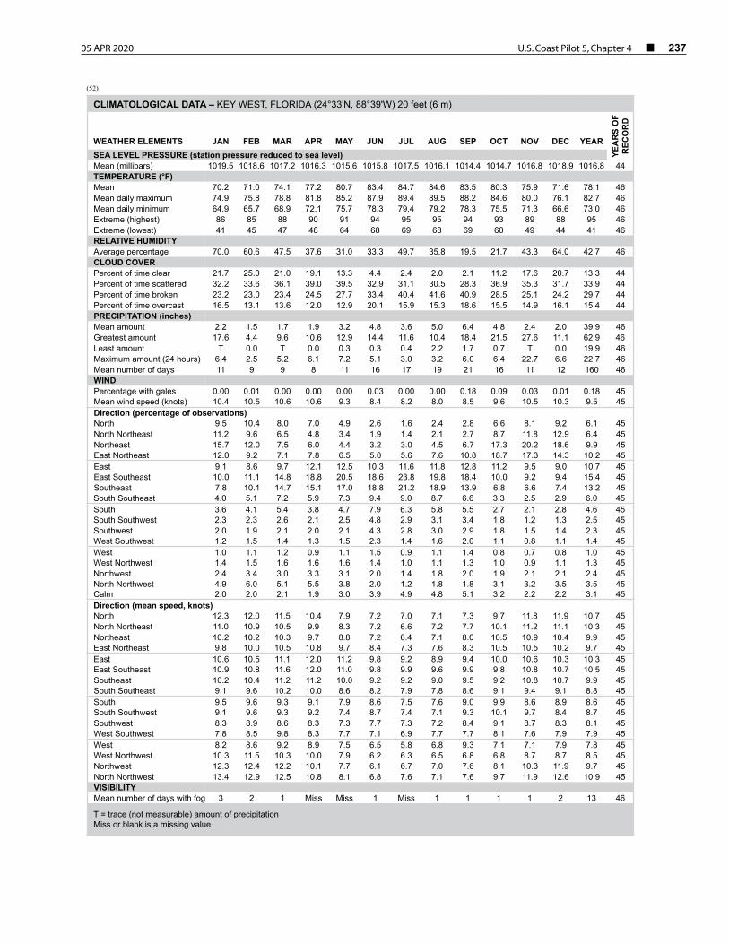
(52)
CLIMATOLOGICAL DATA – KEY WEST, FLORIDA (24°33'N, 88°39'W) 20 feet (6 m)
WEATHER ELEMENTS JAN FEB MAR APR MAY JUN JUL AUG SEP OCT NOV DEC YEAR
YEA
RS
OF
REC
OR
D
SEA LEVEL PRESSURE (station pressure reduced to sea level)Mean (millibars) 1019.5 1018.6 1017.2 1016.3 1015.6 1015.8 1017.5 1016.1 1014.4 1014.7 1016.8 1018.9 1016.8 44TEMPERATURE (°F)Mean 70.2 71.0 74.1 77.2 80.7 83.4 84.7 84.6 83.5 80.3 75.9 71.6 78.1 46 Mean daily maximum 74.9 75.8 78.8 81.8 85.2 87.9 89.4 89.5 88.2 84.6 80.0 76.1 82.7 46 Mean daily minimum 64.9 65.7 68.9 72.1 75.7 78.3 79.4 79.2 78.3 75.5 71.3 66.6 73.0 46 Extreme (highest) 86 85 88 90 91 94 95 95 94 93 89 88 95 46 Extreme (lowest) 41 45 47 48 64 68 69 68 69 60 49 44 41 46 RELATIVE HUMIDITYAverage percentage 70.0 60.6 47.5 37.6 31.0 33.3 49.7 35.8 19.5 21.7 43.3 64.0 42.7 46CLOUD COVERPercent of time clear 21.7 25.0 21.0 19.1 13.3 4.4 2.4 2.0 2.1 11.2 17.6 20.7 13.3 44 Percent of time scattered 32.2 33.6 36.1 39.0 39.5 32.9 31.1 30.5 28.3 36.9 35.3 31.7 33.9 44 Percent of time broken 23.2 23.0 23.4 24.5 27.7 33.4 40.4 41.6 40.9 28.5 25.1 24.2 29.7 44 Percent of time overcast 16.5 13.1 13.6 12.0 12.9 20.1 15.9 15.3 18.6 15.5 14.9 16.1 15.4 44 PRECIPITATION (inches)Mean amount 2.2 1.5 1.7 1.9 3.2 4.8 3.6 5.0 6.4 4.8 2.4 2.0 39.9 46 Greatest amount 17.6 4.4 9.6 10.6 12.9 14.4 11.6 10.4 18.4 21.5 27.6 11.1 62.9 46 Least amount T 0.0 T 0.0 0.3 0.3 0.4 2.2 1.7 0.7 T 0.0 19.9 46 Maximum amount (24 hours) 6.4 2.5 5.2 6.1 7.2 5.1 3.0 3.2 6.0 6.4 22.7 6.6 22.7 46 Mean number of days 11 9 9 8 11 16 17 19 21 16 11 12 160 46 WINDPercentage with gales 0.00 0.01 0.00 0.00 0.00 0.03 0.00 0.00 0.18 0.09 0.03 0.01 0.18 45Mean wind speed (knots) 10.4 10.5 10.6 10.6 9.3 8.4 8.2 8.0 8.5 9.6 10.5 10.3 9.5 45Direction (percentage of observations)North 9.5 10.4 8.0 7.0 4.9 2.6 1.6 2.4 2.8 6.6 8.1 9.2 6.1 45 North Northeast 11.2 9.6 6.5 4.8 3.4 1.9 1.4 2.1 2.7 8.7 11.8 12.9 6.4 45 Northeast 15.7 12.0 7.5 6.0 4.4 3.2 3.0 4.5 6.7 17.3 20.2 18.6 9.9 45 East Northeast 12.0 9.2 7.1 7.8 6.5 5.0 5.6 7.6 10.8 18.7 17.3 14.3 10.2 45 East 9.1 8.6 9.7 12.1 12.5 10.3 11.6 11.8 12.8 11.2 9.5 9.0 10.7 45 East Southeast 10.0 11.1 14.8 18.8 20.5 18.6 23.8 19.8 18.4 10.0 9.2 9.4 15.4 45 Southeast 7.8 10.1 14.7 15.1 17.0 18.8 21.2 18.9 13.9 6.8 6.6 7.4 13.2 45 South Southeast 4.0 5.1 7.2 5.9 7.3 9.4 9.0 8.7 6.6 3.3 2.5 2.9 6.0 45 South 3.6 4.1 5.4 3.8 4.7 7.9 6.3 5.8 5.5 2.7 2.1 2.8 4.6 45 South Southwest 2.3 2.3 2.6 2.1 2.5 4.8 2.9 3.1 3.4 1.8 1.2 1.3 2.5 45 Southwest 2.0 1.9 2.1 2.0 2.1 4.3 2.8 3.0 2.9 1.8 1.5 1.4 2.3 45 West Southwest 1.2 1.5 1.4 1.3 1.5 2.3 1.4 1.6 2.0 1.1 0.8 1.1 1.4 45 West 1.0 1.1 1.2 0.9 1.1 1.5 0.9 1.1 1.4 0.8 0.7 0.8 1.0 45 West Northwest 1.4 1.5 1.6 1.6 1.6 1.4 1.0 1.1 1.3 1.0 0.9 1.1 1.3 45 Northwest 2.4 3.4 3.0 3.3 3.1 2.0 1.4 1.8 2.0 1.9 2.1 2.1 2.4 45 North Northwest 4.9 6.0 5.1 5.5 3.8 2.0 1.2 1.8 1.8 3.1 3.2 3.5 3.5 45 Calm 2.0 2.0 2.1 1.9 3.0 3.9 4.9 4.8 5.1 3.2 2.2 2.2 3.1 45 Direction (mean speed, knots)North 12.3 12.0 11.5 10.4 7.9 7.2 7.0 7.1 7.3 9.7 11.8 11.9 10.7 45 North Northeast 11.0 10.9 10.5 9.9 8.3 7.2 6.6 7.2 7.7 10.1 11.2 11.1 10.3 45 Northeast 10.2 10.2 10.3 9.7 8.8 7.2 6.4 7.1 8.0 10.5 10.9 10.4 9.9 45 East Northeast 9.8 10.0 10.5 10.8 9.7 8.4 7.3 7.6 8.3 10.5 10.5 10.2 9.7 45 East 10.6 10.5 11.1 12.0 11.2 9.8 9.2 8.9 9.4 10.0 10.6 10.3 10.3 45 East Southeast 10.9 10.8 11.6 12.0 11.0 9.8 9.9 9.6 9.9 9.8 10.8 10.7 10.5 45 Southeast 10.2 10.4 11.2 11.2 10.0 9.2 9.2 9.0 9.5 9.2 10.8 10.7 9.9 45 South Southeast 9.1 9.6 10.2 10.0 8.6 8.2 7.9 7.8 8.6 9.1 9.4 9.1 8.8 45 South 9.5 9.6 9.3 9.1 7.9 8.6 7.5 7.6 9.0 9.9 8.6 8.9 8.6 45 South Southwest 9.1 9.6 9.3 9.2 7.4 8.7 7.4 7.1 9.3 10.1 9.7 8.4 8.7 45 Southwest 8.3 8.9 8.6 8.3 7.3 7.7 7.3 7.2 8.4 9.1 8.7 8.3 8.1 45 West Southwest 7.8 8.5 9.8 8.3 7.7 7.1 6.9 7.7 7.7 8.1 7.6 7.9 7.9 45 West 8.2 8.6 9.2 8.9 7.5 6.5 5.8 6.8 9.3 7.1 7.1 7.9 7.8 45 West Northwest 10.3 11.5 10.3 10.0 7.9 6.2 6.3 6.5 6.8 6.8 8.7 8.7 8.5 45 Northwest 12.3 12.4 12.2 10.1 7.7 6.1 6.7 7.0 7.6 8.1 10.3 11.9 9.7 45 North Northwest 13.4 12.9 12.5 10.8 8.1 6.8 7.6 7.1 7.6 9.7 11.9 12.6 10.9 45 VISIBILITYMean number of days with fog 3 2 1 Miss Miss 1 Miss 1 1 1 1 2 13 46
T = trace (not measurable) amount of precipitationMiss or blank is a missing value
238 ¢ U.S. Coast Pilot 5, Chapter 4 05 APR 2020
move northward across Cuba. Statistically, hurricane-force winds can be expected at Key West about once every 15 years and a frequency of 50-knot winds once every 5 years on the average.
(48) Tropical cyclone waves affecting these waters are produced by swell, which advances ahead of the storm, and sea, which is determined by wind direction, which in turn is dependent upon the path of the storm. The deep-water berths outside of North Mole, piers A and B, and Municipal Wharf (Mallory Wharf) are all badly exposed to swells from the southwest. The berths at Naval Air Station Truman Annex are well protected from wave action. The piers off the turning basin north of Key West Bight are affected by waves generated in Man of War Harbor by northerly winds. These conditions can occur in cold winter outbreaks as well as hurricanes. The anchorages in this harbor are protected from sea and swell by the shallow reef north of the turning basin. Key West Bight is sheltered by Stone Mole, and Garrison Bight is also protected from wave action from all quarters. At Safe Harbor, Stock Island, sea and swell from the southern quadrant will cause heavy surf at the harbor entrance; during southerly winds a seiche of 2 to 3 feet inside the harbor is possible.
(49) Storm tides are worst, usually, when an intense hurricane approaches Key West from the Caribbean, passing close to the west. On three occasions since 1900 the streets of the Old Town (greater than 10 feet MSL) have been flooded by such storms. The height of the expected surge will appear in the hurricane warnings. However, there is a large variability in surge heights along the Florida Keys due to their physical characteristics. Tidal currents are considerably magnified by the wind and surge generated by a tropical cyclone. This is particularly evident along the deep western shores where effective storm surge drainage has the advantage of reducing tide heights at main berthing facilities.
(50) For masters of deep-draft vessels, shortages of tug power and lack of protected anchorages and piers at Key West makes an early assessment of a tropical cyclone threat essential. This is best accomplished by using the forecasts in conjunction with climatology. This detailed climatology, as well as the foregoing text and a study of evasion tactics, can be found in the Hurricane Havens Handbook for the North Atlantic Ocean (further details in Chapter 3.) Under the present port circumstances, evasion at sea is the recommended course of action for all seaworthy, deep-draft vessels capable of making 15 knots or more when the port is under threat from a hurricane or an intense tropical storm (50–63 knots).
(51) The National Weather Service maintains an office at the Key West International Airport. Barometers can be compared and weather information obtained by telephone. (See Appendix A for address.)
(53) Pilotage, Key West
(54) Pilotage is compulsory for all foreign and U.S. vessels under register in the foreign trade drawing more than 7 feet (including tugs, barges and tows) bound for or from Key West Harbor, Key West anchorages and Key West channels. Pilotage is optional for U.S. mechanically propelled vessels in the coastwise trade that have on board a pilot properly licensed by the federal government.
(55) Pilotage is available from Key West Bar Pilots Association, P.O. Box 848, Key West, FL 33041, Telephone 305–296–5512.
(56) The Pilot Station is at the northeast end of Front Street, Key West. Pilot Station monitors VHF-FM channels 16 and 14 (when expecting traffic). The 39-foot pilot boat has a gray hull with black trim and gray superstructure with the word PILOT on the side. The 40-foot pilot boat has a green hull and white superstructure with the word PILOT on the side. Occasionally other boats may be used. Pilots board day or night 2 miles south of Key West Harbor Main Channel Entrance Lighted Whistle Buoy KW (24°27'26"N., 81°48'00"W.).
(57) Vessels being boarded should maintain 8 knots and provide a good lee with the ladder 3.34 feet (1 meter) (not dragging) above the water. Seas should be slightly aft of the weather beam. Arrangements for pilots are made through the above telephone number or through ships’ agents. A minimum 24-hour notice of time of arrival is requested; however, pilots will still attempt to service vessels with less time of notice.
(58) The operational guidelines in the Port of Key West are flexible due to changing conditions, different stages of current, tide, bottom shoaling, weather and the change in acceptable risk in emergency situations, Key West being a port of emergency entry as well as a cruise ship port of call and a naval station. The main guideline is a knowledge of seamanship and the port on the part of the pilot and communication of this to the vessel’s master for guidance.
(59) Certain rules of thumb are sometimes used. These are:
(60) 1. Not over 10-foot draft or 250-foot length for transiting Northwest channel, daylight only.
(61) 2. Not over 10-foot draft or 250-foot length for entering Safe Harbor, Stock Island, under normal conditions.
(62) 3. Tankers docking at Pier D-2 North should do so on or near at slack water, daytime only, with at least two tugs, one for port bow, one for aft, docking starboard side to. Deep draft limited to 25.7 feet. Sailing should be daytime only, on or near slack water, with two tugs.
(63) 4. Naval men of war with their sonar dome in the bow may dock at Pier D-2 North, starboard side to, with deep draft limited to 26 feet. If possible, the same current restrictions as for tankers should be used.
(64) 5. All vessels should be limited to not over 29 foot-deep draft, dependant on tide. Some piers require shallower drafts and length limitations. Poorly handling
05 APR 2020 U.S. Coast Pilot 5, Chapter 4 ¢ 239
ships may be restricted even further in draft, and very large poorly handling ships may be restricted to daylight only and in not over 25 knots wind.
(65) 6. Tug assistance may be needed at berths in Key West, even with twin screw bow thrustered ships, due to wind and current. Tugs, however, are not provided; plan ahead if needed.
(66) 7. Key West Harbor is under the International Rules of the Road.
(67) Security calls
(68) All vessels 65 feet or greater and all tugs with tows on entering or leaving Key West Harbor or the Key West Main Ship Channel shall give Security Calls on VHF-FM channels 16 and 13.
(69) Towage
(70) There are no tug boats available in Key West.(71)
Quarantine, customs, immigration and agricultural quarantine
(72) (See Chapter 3, Vessel Arrival Inspections, and Appendix A for addresses.)
(73) Key West is a customs port of entry.(74) Quarantine is enforced in accordance with
regulations of the U.S. Public Health Service. (See U.S. Public Health Service, Chapter 1.) The quarantine anchorage is in Man of War Harbor if size and draft of vessel permit. Larger vessels anchor in the outer harbor.
(75) County and private hospitals are available.(76)
Coast Guard(77) Key West Coast Guard Station is at Pier D-2 on
the northwest side of Key West.(78)
Harbor regulations(79) The City of Key West Port Operations Office has
direct supervision of city docks, properties, moorings and anchorages. This office collects city property port dues. The office telephone number is 305–809–3790. A 5-mph speed limit is enforced in Garrison Bight and in all constricted channel areas.
(80) In the Main Ship Channel, not more than one vessel shall be in the reach of the channel between Lighted Buoys 23 and 25. Vessels in this reach shall have the right-of-way over vessels departing the Truman Annex Basin.
(81) The reach of the channel from Lighted Buoys 14 and 15 to the north end of the Truman Annex Mole shall be kept clear except for vessels able to proceed to their berths without delay. Vessels shall not lie-to in this reach of the channel. If a vessel is unable to proceed because of harbor congestion, she shall pull aside to the westward and lie-to in safe water. No passing is permitted in this reach of the channel.
(82) Vessels shall not overtake or pass in the following areas: between Buoys 2 and 3, in the passage from Western Triangle and Eastern Triangle to Buoys 7 and 8, and in the passage from Buoy 9 to Buoys 14 and 15.
(83) It is permissible to pass in Cut A Range reach between Buoys 7 and 12 after making proper signals, but extreme caution is mandatory when passing in the narrow reaches of the channel.
(84) Vessels that will be delayed in berthing shall notify vessels astern of that fact in order that they may proceed.
(85) Nothing in the above shall relieve masters or commanding officers of their responsibilities for observing the Navigation Rules and the practice of good seamanship.
(86) Wharves
(87) Municipal Wharf, also known as Mallory Wharf (24°33'35"N., 81°48'28"W.), is 870 feet long and has a deck height of about 7 feet. The northerly half is privately owned by a condominium development. The southerly half is operated by the City of Key West Port Operations Office as a cruise ship terminal. Two mooring dolphins off the wharf face provide a total of 464 feet of berthing space with reported depths of 26 feet alongside. For detailed channel information and minimum depths as reported by the U.S. Army Corps of Engineers (USACE), use NOAA Electronic Navigational Charts. Surveys and channel condition reports are available through the USACE hydrographic survey website listed in Appendix A. Potable water is available with advance arrangements. Large vessels must depart the berth 45 minutes before sunset except in emergency or by special arrangement with the City of Key West Operations Office.
(88) Pier B (24°33'22"N., 81°48'33"W.) is another deepwater berthing facility operated by the Pier B Developement Corporation. It has 483-foot face with a mooring dolphin at the north end; deck height about 9 feet. Maneuverable ships up to 1,040 feet have docked here.
(89) Outer Navy Mole (24°33'17"N., 81°48'29"W.), another deepwater berth has a 580-foot face; deck height about 7 feet. Sometimes the mole is used to dock vessels up to 1,040 feet in length, by directions of the City of Key West Port Operations Office.
(90) Municipal Wharf, Pier B, and the Outer Navy Mole are available for emergency dockage. Contact the Key West Pilots Association, ships’ agents or the City of Key West Port Operations Office for further information.
(91) Commercial fish wharves are in Safe Harbor. Charter boats and yachts use Key West Bight, Garrison Bight and Stock Island.
(92) Supplies
(93) Gasoline, diesel fuel, water, ice, provisions and marine supplies can be obtained in Key West.
240 ¢ U.S. Coast Pilot 5, Chapter 4 05 APR 2020
(94) Repairs
(95) There is a small repair yard at Key West on the west side of Garrison Bight. Lifts to 30 tons and engine, hull, electrical, radio and electronic repair facilities are available. Above-the-waterline repairs can also be made to larger vessels. In 1991, shoaling to 3½ feet was reported at the entrance to the yard.
(96) Small-craft facilities
(97) Berths, electricity, water, ice and some marine supplies are available at Key West. Gasoline and diesel fuel are available at Key West Bight and Garrison Bight. A pumpout facility is at a marina in the southwestern part of Key West Bight. Hull, engine, electrical and electronic repairs can be made. Small craft moor in Key West Bight and in Garrison Bight at the Municipal Marina or at the Key West Yacht Club, which are at the southwest and east ends of the bight, respectively. A causeway across the southwest part of Garrison Bight has a small-craft opening. The highway bridge over the opening has a 44-foot fixed span with a clearance of 19 feet at the center. An overhead power cable crossing the north part of Garrison Bight and the entrance has a clearance of 50 feet over the entrance channel and 34 feet elsewhere. Anchoring or mooring elsewhere in Garrison Bight, except in an emergency or as a shelter during bad weather, is not permitted. Public launching ramps are in Garrison Bight and at the foot of Simonton Street.
(98) Communications
(99) There are no rail connections at Key West. Movement of freight in and out of the port is by vessel or truck. The Overseas Highway (U.S. Route 1) connects the city with Miami and points north, and there is air service to Miami. Bus service is available to mainland points.
(100) Boca Chica Key, 5 miles eastward of Key West, is the site of the Key West U.S. Naval Air Station. A naval restricted area extends about 150 yards from the shoreline along a portion of the northeast side of the Naval Air Station. (See 33 CFR 334.610, Chapter 2, for limits and regulations.) BocaChica Channel, with a reported controlling depth of 9 feet in 2000, from Hawk Channel to the naval air station basin on the west side of the key, is marked by a light at the entrance, thence by lights and daybeacons. An overhead power cable has a clearance of 60 feet across the channel. The basin provides a good hurricane anchorage for small vessels in emergencies only.
(101) A restricted area is off the southwest end of Boca Chica Key. (See 33 CFR 334.610, Chapter 2, for limits and regulations.)
(102) Two auxiliary channels marked by private daybeacons lead off Boca Chica Channel. Channel A leads northwest just north of Boca Chica Channel Daybeacon 5. A large boatyard has an entrance on the west side of the channel between Daybeacon 5A and an overhead cable. Transient
berths, hull and engine repairs, water, ice, diesel fuel and an open end travel lift that can haul sail and motor vessels to 75 feet and 75-tons are available.
(103) A marina is north of the overhead cable, which has an authorized clearance of 25 feet at this point. Water, ice, gasoline and hull and engine repairs are available.
(104) In 1986, the reported controlling depth was 6 feet to Daybeacon 5A and then 5 feet to the marina.
(105) Channel B leads northwest from opposite Boca Chica Channel Light 8 toward the Route U.S. 1 bridge. In 1986, the reported controlling depth was 4 feet.
(106) A marina in the northwest corner by highway U.S. 1 has transient berths, hull and engine repairs and gasoline. The following conditions were reported in 1986. Boats proceeding to the marina will find deeper water and avoid obstructions, after passing Daybeacons 6B and 7B, nearer the highway to a point near a boat ramp at the highway, then angling southwest to a spit and following the spit to the marina entrance. Small boats heading north of the highway via the Boca Chica Channel usually pass through at the western end of the bridge where the clearance is less and the water is deeper. Boats passing under the high rise center of the bridge will find shallower water immediately north of the bridge.
(107) Safe Harbor, 4 miles east of Key West, is a medium-draft harbor on the south side of Stock Island. Conspicuous objects include the stack and tanks at a power plant and desalination plant on the east side of the harbor and a large red dry storage building at a marina on the southeast end of Stock Island. A privately dredged channel leads from Hawk Channel into the harbor. A light marks the approach; lights and a daybeacon mark the channel. In 1998, the controlling depth in the entrance channel was 12 feet, with greater depths inside the harbor.
(108) Piers with dolphins on the east side of the harbor near the entrance are used by barges to unload petroleum products for the power and desalination plants. Depths of 18 feet are reported alongside the piers.
(109) The piers on the east and west sides of the harbor are used by cold storage and seafood packing plants; numerous shrimp boats tie up alongside the finger piers.
(110) A boatyard on the west side at the head of the harbor has a mobile hoist that can handle craft to 60 tons. Diesel fuel, water and ice are available. In 1982, a depth of 30 feet was reported alongside the piers at the yard; 300 feet of berthing space was available. A marina on the east side, at the head of the harbor, has transient berths, electricity, water, ice and marine supplies; hull, engine and radio repairs are available. In 1991, the depths alongside the facility was reported to be 18 feet. A facility serving shrimpers and other commercial vessels on the east side of the harbor, just north of the electric plant, has water, ice, diesel fuel and electricity available.
(111) A privately dredged spur channel east of Safe Harbor leads to a large marina on the southeast end of Stock Island.The channel is marked by private daybeacons. Berths, gasoline, diesel fuel, water, ice, electricity, a launching ramp, storage and complete marine supplies
05 APR 2020 U.S. Coast Pilot 5, Chapter 4 ¢ 241
are available. A forklift can haul out craft to 25 feet for hull and engine repairs. The dockmaster can be contacted on VHF-FM channel 16.
(112) Cow Key Channel, between Stock Island and Key West, is narrow and marked by private daybeacons. A shoal that bares is about 0.2 mile south-southwest of the southwest point of Cow Key. The channel is subject to frequent change—mariners are advised to seek local knowledge before entering the channel. Two fixed highway bridges with a horizontal clearance of 36 feet and vertical clearance of 9 feet cross the channel between the keys. An overhead power cable at the bridges has a vertical clearance of 25 feet. The channel north of the highway bridges is difficult to follow.
(113) Three radio antennas on the east side of the channel are prominent. A marina on the east side of the channel at the bridges can provide transient berths, a launching ramp, water, ice, storage and some marine supplies. Another marina on Stock Island has berths, gasoline, storage and marine supplies. A forklift can haul out boats to 25 feet for engine repairs. To avoid the restricted passage of Cow Key Channel, vessels may use Garrison Bight Channel to the north end of Fleming Key. From the channel, head easterly, north of Sigsbee Park to a dredged channel on the east side and follow the dredged channel to the marina. In 1986, the reported controlling depth was 4 feet for approximately 150 yards just east of Sigsbee Park and west of the beginning of the dredged channel. Elsewhere, the controlling depth was 8 feet or greater.
(114) ENCs - US4FL92M, US3FL90M Charts - 11439, 11434
(115) The area from Key West for 63 miles west to Dry Tortugas is a continuation of the keys with their intervening reefs and shoals. The keys are low, small in extent and, except for the Dry Tortugas, generally covered with dense growths of mangrove.
(116) About 5 miles south of the main chain of keys and reefs is a line of reefs, shoals and generally broken ground that rises abruptly from the deep water of the Straits of Florida. Buoys, lights and daybeacons mark the outer reefs. Deep-draft vessels standing along the keys should avoid this broken ground and also the areas with depths less than 10 fathoms, south and west of Rebecca Shoal and the Dry Tortugas.
(117) Currents are variable along the edge of the reefs, being influenced by winds, by differences of barometric pressure in the Gulf and the Straits of Florida and by the tides. At times there are strong tidal currents through the passages between the keys.
(118) Between Key West Harbor and Boca Grande Channel there is an extensive shoal area in which are several small scattered keys. The white sand beaches of the southernmost keys are easily discernible from seaward. A large house on Ballast Key (24°31.3'N., 81°57.8'W.) is reported to be prominent.
(119) A small-craft channel, marked by private daybeacons, extends through the shoal area from Key West to the north side of Boca Grande Key. The channel has a reported controlling depth of 5 feet except south of Mule Key, near Key West, where the controlling depth is 2 feet. Local knowledge is advised. In 2009, unexploded ordinance was reported about ½ mile north of Boca Grande Key within a 200-yard radius of a visible wreck at 24°32'37"N., 81°59'56"W. Mariners are advised not to anchor in this area; caution is advised.
(120) Key West National Wildlife Refuge extends west from Key West to Marquesas Keys.
(121) Boca Grande Channel, between Boca Grande Key and the Marquesas Keys, is about 15 miles west from Key West. The channel has a controlling depth of about 11 feet from the Straits of Florida to the Gulf of Mexico and is marked by daybeacons but is seldom used except by local boats of 6 feet or less draft. The channels through Key West Harbor are deeper and better marked and offer a shorter passage from the Gulf to the Straits of Florida.
(122) Currents
(123) In Boca Grande Channel the average velocity of the current is 1.2 knots; the flood current sets north and the ebb south-southwest. The velocity of the current is considerably influenced by the winds.
(124) The Marquesas Keys, on the west side of Boca
Grande Channel, are 4 miles in extent and surrounded by a large shoal area. The northernmost key is the largest and has a strip of sandy beach free of mangrove.
(125) Mooney Harbor is a central lagoon within Marquesas Keys. The main entrance, close west of Gull Keys, was reported closed by shoaling in 1987. It is reported, however, that good, protected anchorage can be found in 1 to 4 feet with good holding ground in a small lagoon close southwest of Mooney Harbor Key. Another good anchorage was reported southeast of Mooney Harbor with a 4-foot entrance marked by pipes and deeper water within. Entrance into the central lagoon is restricted by a shoal. The lagoon should be entered only during daylight hours and caution should be exercised.
(126) Ellis Rock, 4 miles northwest of the Marquesas Keys, is covered 7 feet and surrounded by depths of 21 to 39 feet; the rock is marked by a light.
(127) Danger zones of bombing and strafing target areas, centered on targets, are in the vicinity of Marquesas Keys. (See 33 CFR 334.620, Chapter 2, for limits and regulations.)
(128) A large shoal, the west part of which is known as The Quicksands, extends 18 miles west from the Marquesas Keys. The shoal is about 4.5 miles wide between the 18-foot curves and has a least depth of 2 feet over its east part. A strong east to west current was observed in the area of The Quicksands in 1975.
242 ¢ U.S. Coast Pilot 5, Chapter 4 05 APR 2020
(129) Halfmoon Shoal, covered 8 feet, is off the west end of The Quicksands. A wreck covered 6 feet and marked by a light is on the west edge of the shoal.
(130) New Ground, a shoal with a least depth of 4 feet at its west end, is about 6 miles long. It extends in an east-west direction about 3.5 miles north of The Quicksands. A light is on the west side of the 4-foot spot. The water shoals abruptly on the north side of New Ground, and vessels should stay in depths greater than 13 fathoms to ensure clearing the shoal.
(131) Between New Ground and The Quicksands is a natural channel about 2 miles wide with depths greater than 30 feet. The route should be used with caution because of the general irregularity of the bottom inside the 10-fathom curve.
(132) A channel, sometimes used, lies west of Halfmoon Shoal but is not recommended. Southwest of Halfmoon Shoal depths of 20 to 22 feet rise abruptly from depths of about 40 feet.
(133) Isaac Shoal, 5 miles west of Halfmoon Shoal and 2 miles southeast of Rebecca Shoal, is covered 14 feet. The shoal rises from depths of 30 to 60 feet.
(134) Rebecca Shoal, 43 miles west of Key West, is a small coral bank covered 11 feet. An abandoned square skeleton tower that once supported a light is on the south edge of the shoal. Depths of 18 feet are reported within 1 mile southeast and west of the shoal. A lighted buoy marks the southwest edge of the shoal.
(135) Currents
(136) At Isaac Shoal, the current floods north with an average velocity of about 1 knot and ebbs south with an average velocity of about 0.8 knot. The velocity of the current is considerably influenced by the wind.
(137) The current south of New Ground Shoal has an average velocity of 0.7 knot with the flood setting northeast and the ebb southwest. The velocity and direction of the current are influenced considerably by the wind.
(138) ENC - US3FL90M Chart - 11434
(139) A channel between Rebecca Shoal and the Dry Tortugas frequently is used by vessels bound from the Straits of Florida to points on the west coast of Florida. Vessels bound for Mobile and points west pass to the west of the Dry Tortugas. So far as known, the channel is clear, but there may be undiscovered spots with lesser depths than those now charted. Deep-draft vessels should use the passage with great caution and should continue about 15 miles past the lighted buoy, 8 miles south-southeast of Halfmoon Shoal, before turning north.
(140) ENC - US5FL91M Chart - 11438
(141) The Dry Tortugas are a group of small keys and reefs 63 miles west from Key West. The group is about 11 miles long, in a northeast-southwest direction, and 6 miles wide. Pulaski Shoal, at the northeast end of the group, is 12 miles northwest of Rebecca Shoal. Pulaski Shoal Light (24°41'36.0"N., 82°46'22.7"W.), 56 feet above the water, is shown from a small black house on a hexagonal pyramidal skeleton tower on piles on the east side of the shoal.
(142) The keys are low and irregular and have a thin growth of mangrove. In general, they rise abruptly from deep water and have fairly good channels between them. They are continually changing in size and shape.
(143) Garden Key is the site of historic Fort Jefferson National Monument, a hexagonal structure with walls 425 feet long rising from a surrounding moat. The fortress, once a military prison, is now a government reservation administered by the National Park Service. An abandoned lighthouse, 67 feet high, is behind the southeast bastion. A fixed white light, visible at least 8 miles, is displayed at night from the tower by the National Park Service. Garden Key and the surrounding waters of the Dry Tortugas are subject to rules and regulations prescribed by the Secretary of the Interior. Commercial fishing is prohibited within these waters.
(144) The south and north of the three wharves on the east side of the key are in ruins. The center wharf, off the southeast front of the fort, is in good condition, with 16 to 22 feet alongside. No fuel, provisions or water are available. The National Park Service permits berthing for a maximum of 2 hours.
(145) Small craft should not try to make Dry Tortugas from Key West because of the rough nature of the sea around Rebecca Shoal.
(146) Loggerhead Key, the other of the two principal keys in the Dry Tortugas, is 2.5 miles west of Garden Key. Dry Tortugas Light (24°38'00"N., 82°55'14"W.), 151 feet above the water, is abandoned and shown from a 151-foot conical tower, lower half white and upper half black, near the center of Loggerhead Key.
(147) Fort Jefferson and Dry Tortugas Light are good landmarks and can be seen at a distance of 10 to 12 miles on a clear day. Fort Jefferson has the appearance of a bare rocky island and is an excellent radar target at distances greater than 12 miles.
(148) Bush Key, just east of Garden Key, is a refuge for noddy and sooty terns. These birds come in early April and leave in September.
(149) When approaching the Dry Tortugas from east or southeast, soundings give little warning of danger, as depths of 10 to 15 fathoms are found close to the reefs in many places. The water shoals more gradually in the approaches from northwest or southwest, but an
05 APR 2020 U.S. Coast Pilot 5, Chapter 4 ¢ 243
approaching vessel should stay in depths greater than 15 fathoms if uncertain of her position.
(150) Southeast and Southwest Channels are the principal approaches; both are marked, and the shoals can be identified on a clear day by the difference in color of the water. Northwest Channel is unmarked.
(151) Southeast Channel skirts the reefs south of East Key and Middle Key and passes between the 25-foot shoal south of Hospital Key and Iowa Rock off Bush Key Shoal. Iowa Rock is marked by a light. The reefs south of Middle Key can be cleared by keeping south of a line through the abandoned lighthouse on Fort Jefferson and Dry Tortugas Light. The channel has depths of 20 feet or more, but it should be used with caution by vessels drawing more than 18 feet.
(152) In Southeast Channel, 1 mile east of Garden Key, the current floods north and ebbs south with an average velocity of 0.6 knot.
(153) Southwest Channel leads between the reefs west and southwest of Garden Key and those off Loggerhead Key. The least depth found along the marked channel is 31 feet, but the same caution is advised as with Southeast Channel.
(154) Among the reefs and keys are numerous places where vessels can anchor and find shelter from seas from various quarters. A good anchorage, although somewhat open to the north, is north and northwest of Garden Key. The holding ground is good, and the depths range from 8 to 10 fathoms.
(155) Excellent anchorage for small craft is found in the deep water of Bird Key Harbor, reached through the narrow channel encircling Garden Key, which is well marked. The entrance to Bird Key Harbor is narrow, and care is required to avoid the shoals on either side. The main entrance channel is marked by daybeacons.
(156) In emergencies, the best shelter is southwest of Garden Key and the channel encircling it, where protection is afforded from northwest winds. However, the holding ground is poor, as boats drag anchor along the silty bottom.
(157) A general anchorage is in Bird Key Harbor. (See 33 CFR 110.1 and 110.190, Chapter 2, for limits and regulations.)
(158) Currents
(159) In Southwest Channel, 1 mile south of Loggerhead Key, the current floods north and ebbs southwest at an average velocity at strength of 0.5 knot. In Southeast Channel the current floods north and the ebb south at an average velocity at strength of 0.6 knot.
(160) ENC - US3FL90M Chart - 11434
(161) For 10 miles west from the Dry Tortugas the bottom is broken and irregular and consists of coral rock with patches of sand and broken shell. Tortugas Bank, the
shoalest part of this area, is 7 miles west of Loggerhead Key and has a least known depth of 37 feet. Depths less than 10 fathoms are found for a distance of 2.5 miles in all directions. Between Tortugas Bank and the Dry Tortugas the depths range from 7¼ to 19 fathoms. Deep-draft vessels should avoid Tortugas Bank, especially in heavy weather.
(162) ENC - US3GC07M Chart - 11420
(163) From Cape Sable to San Carlos Bay the west coast of Florida is low, sandy and generally wooded and has few distinguishing features. Back of the coast is an extensive swampy region, thinly settled, known as The Everglades. Off the coast the water is generally shoal, and the 10-fathom curve roughly approaches a line drawn north-northwest from Key West to Tampa Bay. This part of the coast is seldom approached by deep-draft vessels.
(164) Moderate-draft vessels bound up the coast from Key West can lay a straight course from Northwest Channel to Sanibel Island Light at the entrance to San Carlos Bay, a distance of 118 miles from Key West. This course is well clear of all dangers, and the light on Sanibel Island is a good landmark day or night. Because of frequent northers during the winter, this track is not recommended for small craft, and the route across Florida Bay is to be preferred.
(165) ENC - US4FL97M Chart - 11442
(166) Moser Channel, 36 miles east of Key West, affords passage between the keys from the Gulf of Mexico to Hawk Channel for vessels of 7 to 8 feet in draft. The swing span of Seven Mile Bridge across Moser Channel has been removed; however, the bridge piers remain. The fixed highway bridge close south of the former swing span has a clearance of 65 feet.
(167) The tidal current at the bridge floods north-northwest with an average velocity of 1.4 knots and ebbs south-southeast with an average velocity of 1.8 knots. Wind effects modify considerably the current velocities and directions.
(168) ENCs - US4FL20M, US4FL26M Charts - 11462, 11452
(169) Florida Bay, a triangular-shaped body of water between the Florida Keys and the south coast of the mainland, extends in a general east-west direction from Shell and Bogie Keys to Cape Sable. Depths are shallow and irregular; the bottom is mostly mud. From April to October the waters of the bay are clear and the shoals plainly discernible, but during the winter the water frequently turns milky and renders the shoals indistinguishable.
244 ¢ U.S. Coast Pilot 5, Chapter 4 05 APR 2020
(170) In the east part of the bay are small keys and numerous mudflats that bare, or nearly bare, at low water. The west part of the bay has depths ranging from 7 to 13 feet, and the bottom is covered with loggerhead sponges and turtle grass.
(171) A protected area of the Everglades National Park is in the northern part of Florida Bay.
(172) For the protection of wildlife, all keys in the Florida Bay portion of Everglades National Park are closed to landing except those marked as designated camping areas. The killing, collecting or molesting of animals, the collecting of plants and waterskiing are prohibited by federal regulation.
(173) Manatees
(174) Regulated speed zones for the protection of manatees are posted throughout the Everglades National Park.
(175) COLREGS Demarcation Lines
(176) The lines established for Florida Bay are described in 33 CFR 80.740, Chapter 2.
(177) ENC - US5FL48M Chart - 11433
(178) Flamingo, on the mainland about 9 miles east of East Cape (25°07'N., 81°05'W.), is a tourist center in Everglades National Park at the entrance of Buttonwood (Flamingo) Canal. A 300-foot tower east of the canal about 0.3 mile northeast of the visitors center is prominent. A privately dredged channel leads from the 7-foot contour of Florida Bay to the canal entrance. The channel is marked by lights, buoys and daybeacons. A dam blocks the canal about 200 yards above the entrance. Boat ramps at the dam allow the passage of craft to 26 feet long from Florida Bay to Coot Bay and Whitewater Bay. A highway bridge, about 0.5 mile above the mouth of the canal, has a reported 45-foot fixed span and a clearance of 10 feet. A marina on the west side of the canal just below the dam at Flamingo has berths with electricity, water, ice, and limited marine supplies. Gasoline, diesel fuel and launching ramps are available on either side of the dam. A 5-mph no-wake speed limit is enforced in the canal.
(179) ENCs - US4FL26M, US4FL46M, US4FL44M, US-5FL44M Charts - 11452, 11431, 11429
(180) Cape Sable, the low and wooded southwest tip of the Florida Mainland, has three points known as East Cape, Middle Capeand Northwest Cape. These are relatively steep-to and are partially cleared.
(181) Small vessels can find anchorage 1.5 miles southeast of East Cape in 7 to 8 feet of water. The even marl bottom is good holding ground, but the anchorage is reported to be unsheltered from winds, particularly from west.
Vessels should anchor bow and stern to avoid being set onto the beach. East Cape Canal, a drainage canal opening into Florida Bay 1 mile east of East Cape, offers good protection for any boat that can enter. A depth of 2 to 3 feet can be carried into the canal at low water by approaching from due south. Fishing and pleasure craft frequent this area, but local knowledge is necessary to avoid the numerous snags inside the canal.
(182) From Northwest Cape the coast trends north for 20 miles, then northwest for about 30 miles to Cape Romano. Along this stretch of coast are the Ten Thousand Islands, innumerable small islands and keys interlaced by a network of small rivers and bayous leading to the interior. The islands and keys are generally lumps of mud, low and densely wooded and almost impossible for a stranger to identify. Small in size, they are mostly awash at high water and fringed with oyster reefs. Except for the lights marking the offshore boundary of the Everglades National Park, the only other useful marks along this stretch of the coast are the light at the entrance to Little Shark River and the slightly higher growths of timber on Shark River Island, Shark Point and Highland Point. The water is shallow for a distance of 10 miles from the coast, depths of 7 feet being found as much as 3 miles offshore. With local knowledge, drafts of 3 to 6 feet can be carried into many of the rivers.
(183) The rivers and inland lakes to the north of Northwest Cape are frequented mostly by fishing parties, particularly during the winter season. Strangers are advised to hire guides at Flamingo, Marco or Everglades City. The rivers afford good anchorage for craft able to cross the bars off the entrances.
(184) ENCs - US5FL48M, US5FL47M Charts - 11433, 11432
(185) Small craft can traverse the system of tidal bays, creeks and canals from Flamingo Visitors Center to the Gulf of Mexico, 6 miles north of Northwest Cape. The route through Buttonwood Canal, Coot Bay, Tarpon Creek, Whitewater Bay, Cormorant Pass, Oyster Bay and Little Shark River is marked by daybeacons. The controlling depth is about 3½ feet.
(186) The route from Flamingo to Daybeacon 48, near the west end of Cormorant Pass, is part of the Wilderness Waterway.
(187) Wilderness Waterway (see also chart 11430) is a 100-mile inside passage winding through the mangrove wilderness of Everglades National Park from Flamingo on Florida Bay to Everglades City on the Gulf of Mexico. From Daybeacon 48, near the west end of Cormorant Pass, the waterway leads north through Shark Cutoff and then through various creeks, rivers and open bays to Everglades City. The passage above Cormorant Pass is marked by the National Park Service. The National Park Service advises that boats with cabins or high windshields or boats over 18 feet in length should not
05 APR 2020 U.S. Coast Pilot 5, Chapter 4 ¢ 245
attempt the entire passage, because of the narrow creeks and overhanging branches along some portions of the waterway. The section of the waterway that transits Broad Creek and The Nightmare, an area between Harney River and Broad River, should only be attempted by canoes or kayaks.
(188) Manatees
(189) Regulated speed zones for the protection of manatees are posted in the Wilderness Waterway.
(190) Maps of the waterway and other information are contained in a booklet entitled, “A Guide to the Wilderness Waterway of the Everglades National Park,” published by the University of Miami Press, Drawer 9088, Coral Gables, FL 33124.
(191) Ponce de Leon Bay is a nearly rectangular bight 7 miles north of Northwest Cape. Shark Point, on the north side of the bight, and Shark River Island, on the south side, are heavily wooded to the water’s edge and stand out in bold relief against the tree line at the head of the bight. The north part of the bight is shallow, but fair anchorage is available for vessels drawing up to 6 feet off Shark River Island. The anchorage is sheltered from winds east of north or south, and the shoal on the northwest affords considerable protection from that direction. Several narrow streams empty into the head of the bight. Boats drawing up to 5 feet can continue into the southernmost of these streams.
(192) The area for some 10 miles east and southeast of Ponce de Leon Bay is a complicated network of tidal channels around thousands of mangrove islands. These channels lead or enlarge into Oyster, Whitewater and Tarpon Bays, from which, in turn, shallow rivers lead back into The Everglades. Generally, a depth of 5 feet can be carried through the various passes into Oyster and Tarpon Bays by giving a good berth to the points, which often have tidal bars projecting out from them.
(193) Oyster Bay is about 2 miles inland from the southeast corner of Ponce de Leon Bay. At the south end of Oyster Bay is the entrance to Joe River, a tidal channel extending some 10 miles in a southeast direction to the south end of Whitewater Bay. A depth of 4 feet can be carried through Oyster Bay and Joe River by avoiding occasional bars.
(194) Numerous channels lead east from Oyster Bay through a belt of mangrove about 2 miles wide into Whitewater Bay. The latter has numerous low mangrove islands, and its brackish water is from 2 to 6 feet deep. Northeast winds often cause drops in the water level of a half foot. At the south end of Whitewater Bay, Tarpon Creek leads into Coot Bay, which is about 1 mile in diameter and 3 feet deep. A 5-mph no-wake speed limit is enforced in Tarpon Creek. Boats going to and from Whitewater and Coot Bays can use Joe River, which is the southernmost passage, is easy to follow and is deep enough for all boats that can navigate the bays.
(195) Little Shark River, which empties into the Gulf on the south side of Shark River Island about 6 miles north of Northwest Cape, is a good channel to Oyster Bay for vessels drawing 4 feet or less. The river also provides anchorage of limited extent but is well protected. An entrance light and daybeacons as far as Oyster Bay mark the channel. Little Shark River trends east-northeast from Oyster Bay to a junction with Shark River about 7 miles above the entrance light.
(196) Shark River is the channel emptying into the middle of the east side of Ponce de Leon Bay. Some 8 miles northeast, the channel joins Harney River and enlarges into Tarpon Bay. A depth of about 5 feet can be carried through Shark River and Tarpon Bay. Shallow rivers lead north and east from Tarpon Bay into the Everglades.
(197) Harney River, emptying into the Gulf about 11 miles north of Northwest Cape, is a good passage to Tarpon Bay. Numerous bars at the entrance limit the depth to 2½ feet.
(198) Broad River and Rodgers River enter the Gulf about 16 miles north of Northwest Cape. In 1982, it was reported that about 2½ feet could be taken over the bar 1.5 miles southwest of the entrance to Broad River. Vessels of that draft can anchor just outside the mouths of the rivers and be protected from the sea by the bars outside. These rivers extend back into The Everglades for about 15 miles. About 6 miles from the coast they connect with a chain of shallow bays and creeks that extend north along the coast for some 60 miles. Small craft drawing up to 1½ feet can traverse these inside passages from Broad River to Naples. However, the charts do not cover this area completely; local knowledge is required to navigate north of Everglades City to Marco.
(199) ENCs - US5FL45M, US5FL4AM Chart - 11430
(200) Lostmans River is entered through First Bay, which is about 19 miles north of Northwest Cape. Local boatmen use the north entrance to the river. A depth of about 3 feet can be carried some 10 miles back into this river, which drains a large area of shallow bays. The crooked winding channel is marked by private daybeacons.
(201) ENCs - US4FL46M, US5FL45M, US5FL4AM Charts - 11431, 11430
(202) Seminole Point (25°36.9'N., 81°16.3'W.), 24 miles north from Northwest Cape, is fairly prominent when standing up the coast at a distance of 2 to 3 miles off. The point is the southwest end of Plover Key and is the most west land seen until Pavilion Key is picked up to the northwest.
(203) ENCs - US4FL44M, US5FL44M, US5FL45M, US-
246 ¢ U.S. Coast Pilot 5, Chapter 4 05 APR 2020
5FL4AM Charts - 11429, 11430
(204) Pavilion Key (25°41.4'N., 81°21.2'W.), 30 miles north of Northwest Cape, is the first prominent land seen after leaving Seminole Point. Anchorage is available for drafts of 4 to 5 feet off the east point of the south end of Pavilion Key. The anchorage is exposed to southwest winds. The approach to the anchorage passes close west of Dog Key, 0.3 mile southeast of Pavilion Key.
(205) Chatham River and Huston River empty into the Gulf 3 miles east of Pavilion Key. These rivers offer a connection to the system of shallow bays which parallel the coast. In 1982, it was reported that a draft of about 1½ to 2 feet could be taken up these rivers, but local knowledge is necessary to avoid the numerous bars.
(206) Jewel Key (25°47.1'N., 81°25.1'W.), 6 miles north-northwest from Pavilion Key, marks the entrance to Chokoloskee Pass, the approach to the town of Chokoloskee. Jewel Key is a small flat island.
(207) Chokoloskee is a year-round community on an island, about 0.5 mile in diameter, near the southeast end of Chokoloskee Bay about 3 miles east-northeast of Jewel Key. The island is joined to the mainland near Everglades City by a long causeway, which has a bridge opening off the mouth of Halfway Creek. The 23-foot fixed span has a clearance of 5 feet. Two channels, privately marked by stakes, lead from the Gulf through Rabbit Key Pass and Chokoloskee Pass to the facilities at Chokoloskee. In 1982, it was reported that the channel through Rabbit Key Pass was closed and that with local knowledge 2 feet could be carried in the channel through Chokoloskee Pass. At low water, during periods of north winds, it was reported that very little water remains in these channels and the bay dries out for the most part. At these times local knowledge is essential. There is no marked channel across the bay from the island to the entrance to Barron River, but with local knowledge craft drawing up to 1 foot can make it ordinarily. A channel leads from the vicinity of Jewel Key through Sandfly Pass and thence into a privately dredged channel, marked by privately maintained daybeacons, across the bay to the National Park Service basin at the northwest end of the causeway. In 2000, the channel had a reported controlling depth of 2 feet with lesser depths reported in the basin.
(208) The island has three marinas. One is at the north end on the east side of the causeway, and two are on the west side of the island. Two marinas have protected basins. All have gasoline, water, and ice available. A boatyard on the east side of the island has a marine railway that can handle craft to 53 feet for hull and engine repairs.
(209) Indian Key, on the west side of the entrance to the pass, is wooded and, except for its shape, resembles the neighboring keys. Good anchorage is available in Indian Key Pass about 700 yards northeast of Indian Key in depths of 8 to 13 feet and about 1 mile northeast of the key in 12 to 15 feet, gravel bottom. The anchorage is well
protected from all winds, is suitable for drafts up to 7 feet, and is easily entered day or night.
(210) Indian Key Pass (25°48.0'N., 81°28.0'W.), 38 miles north of Northwest Cape, is the approach to Everglades City. A dredged channel leads from the Gulf of Mexico through Indian Key Pass, across Chokoloskee Bay, and up the Barron River to a turning basin about 1.3 miles above the mouth of the river.The channel is well marked by lights and daybeacons. Overhead power cables with clearances of 65 feet and 49 feet cross the river about 0.5 and 0.7 mile above the mouth, respectively. A 5-mph no-wake speed limit is enforced on the river.
(211) In 1983, the microwave tower at Everglades City was reported to be a good landmark from offshore although it is obscured closer in. When making the approach to Indian Key Pass, it is reported that mariners should steer about 053° for the microwave tower while it is visible, then hold that course until Indian Key Pass Light 1 can be identified. The light is reported to be difficult to distinguish from its background.
(212) A privately dredged channel, marked by daybeacons, leads southeast from the channel at the mouth of the Barron River to a turning basin and the protected basin of the National Park Service. In 2000, depths of less than 4 feet were reported in the channel with shoaling in the basin. A visitors center of The Everglades National Park is at the basin.
(213) Indian Key Pass Light (25°47'59"N., 81°28'04"W.), 16 feet above the water and shown from a pile on the south end of the bank extending off the south end of the key, marks the entrance to the pass. The mean range of tide is 3.4 feet at Indian Key.
(214) Everglades City, about 0.5 mile above the mouth of the Barron River, is the tourist center for Everglades National Park. Itis also a center for sport fishing in The Evergladesand the offshore waters of the Gulf. It is 3 miles by road, on State Route 29, from the Tamiami Trail (U.S. Route 41), the main highway across The Everglades from Miami to Tampa. The town has several marinas.
(215) Local fishing guides will act as pilots for The Everglades and adjacent waters of the Gulf.
(216) The mean range of tide is 2.0 feet at Everglades City.(217) West Pass, 2.8 miles northwest from Indian Key,
extends generally northeast for 3 miles from the north side of Tiger Key to West Pass Bay. A draft of 2 feet can be taken to West Pass Bay, thence east into Chokoloskee Bay and southeast to Barron River and Everglades City. West Pass is unmarked.
(218) Fakahatchee Pass, 4 miles northwest from Indian Key, extends northeast for 3 miles from the west side of Round Key to Fakahatchee Bay.
(219) Faka Union Canal, 6.5 miles northwest of Indian Key, is entered through a channel east of Panther Key that extends north for 4 miles through Faka Union Bay and Faka Union River. Private daybeacons mark the channel as far as Faka Union Bay. At the head of the canal is a marina that provides berths with electricity, gasoline, water, ice, marine supplies, wet and dry storage,
05 APR 2020 U.S. Coast Pilot 5, Chapter 4 ¢ 247
a pump-out facility, and a launching ramp. In 2006, a reported approach depth of 4 feet could be carried to the marina.
(220) Manatees
(221) Regulated speed zones and a caution zone for the protection of manatees are in Faka Union Bay, River and Canal. (See Manatees, Chapter 3.)
(222) Cape Romano is the south end of a large island 78 miles north from Key West. Here the coast changes its trend from northwest by west to north-northwest.
(223) North of Cape Romano deep water approaches the coast much more closely than it does south of the cape, and the coast is quite regular in outline although broken by many small inlets. The 12-foot curve is less than 0.5 mile offshore except at the entrances to some of the passes. The mouths of the passes are usually small and difficult to recognize unless close to shore. These passes are subject to change, developing and filling in rapidly, making local knowledge mandatory. There are several prominent apartments and hotels along the beach on the west side of Marco Island. Readily identifiable are the light at Capri Pass, and the pier, buildings, microwave tower and water tanks at Naples.
(224) Cape Romano Shoals, extending 10 miles south from the cape, are a series of irregular patches that bare in places near the shore and have depths of 1 to 20 feet over them farther off. A light marks the south end of the shoals. There is a strong current around the shoals, particularly on the seaward side and during spring tides. The mean range of tide at Cape Romano is 2.6 feet. The flood current sets south and the ebb north. In 1982, it was reported that the character of Cape Romano Shoals appeared to be changing and that in some areas lesser depths than those charted may exist. It was further reported that breakers were observed and that shoaling to 6 feet was reported in about 25°46'21"N., 81°42'55"W. In 1980, shoaling to 4 feet was within a 0.5-mile radius of 25°49'27"N., 81°41'33"W. Mariners are advised to exercise caution in this area.
(225) A fish haven, with a minimum depth of 15 feet, is 6.1 miles west-northwest from Cape Romano.
(226) Gullivan Bay is between Cape Romano and the islands to the east. At the head of the bay is Coon Key Pass. The pass is marked by daybeacons and is the south approach to Goodland and Big Marco River. A marked channel leads northwestward from Gullivan Bay to Caxambas Bay and Caxambas Pass. The approach from southeast is marked by Coon Key Light (25°52'54"N., 81°37'56"W.), 22 feet above the water and shown from a pile with a red and white diamond-shaped daymark. In 1992, a submerged wreck was on the west side of the pass above Daybeacon 2 in about 25°54'21.6"N., 81°38'22.8"W. As Coon Key is neared, the land behind becomes visible, but the key stands well above everything in the vicinity. When nearly up to the key, the entrance to Big Marco River is seen to east as a narrow gap between
the more distant keys. The mean range of tide is 2.6 feet at Coon Key.
(227) Caxambas Pass, The channel through Caxambas Pass is about 4 miles northwest of Cape Romano and runs directly adjacent to the south shoreline of Big Marco Island. The area included in and surrounding the channel is subject to continual change; mariners should seek local knowledge before transiting the channel. Private daybeacons marking the pass are not charted. The area immediately south of the pass is extremely shoal and marked with danger beacons. Just south of the shoal area, is an unmarked row of piles that are the remains of an old jetty extending north and west fromDickmans Point, the north end ofKice Island.
(228) Big Marco Pass, 8 miles north from Cape Romano, is completely closed off by a barrier island. Shoals extend 1 mile seaward from the former pass and the area is subject to continual change. A fish haven with a minimum depth of 10 feet is about 2 miles southwest of this shoal area.
(229) Capri Pass, about 0.5 mile north of Big Marco Pass, is used by boatmen to gain entrance to inland waters that were formerly entered through Big Marco Pass. Local knowledge is advised. The entrance is marked by lights and daybeacons.
(230) Big Marco River trends east and then south for about 11 miles from Big Marco Pass to Gullivan Bay and affords a through passage behind Cape Romano. The midchannel controlling depth is about 4 feet; however, there have been numerous reports of shoaling between Capri Pass Light 2 and Big Marco River Daybeacon 18. Vessels drawing 2 feet or more should exercise caution and obtain local knowledge before attempting passage. The channel, though narrow and crooked, is well marked by daybeacons. The approach from Gullivan Bay is over shallow water with a depth of 4 feet and is marked by Coon Key Light. This approach is protected from all directions except southeast to southwest, and any sea from those directions is reduced by the wide expanse of gradually shoaling water. Local knowledge of conditions is necessary to carry the best water through the channel.
(231) A fixed highway bridge with a clearance of 55 feet crosses Big Marco River about 3 miles north of Coon Key. The approach piers of the former swing bridge immediately south of the fixed bridge remain and are used as fishing piers. An overhead power cable just south of the highway bridge has a clearance of 81 feet. A fixed highway bridge, connecting Bear Point and Marco Island, about 2.3 miles east of Capri Pass, has a clearance of 55 feet. An overhead power cable with a clearance of 77 feet at the center span and 55 feet reported elsewhere is close west of the bridge. A new bridge is under construction adjacent to the existing bridge.
(232) Marco Island, a large island situated between Caxambas Bay, Big Marco Pass, and Big Marco River, has for the most part been developed as a residential year-round community. Canals have been dredged and the marshland backfilled to provide for waterfront homesites.
248 ¢ U.S. Coast Pilot 5, Chapter 4 05 APR 2020
(233) Goodland is a small fishing village and winter resort on Big Marco River at the east end of Marco Island. Several fish wharves and small-craft facilities are at the village. Local fishing guides are available and will act as pilots for the waters.
(234) Marco is a settlement at the north end of Marco Island on the south side of Big Marco River about 1 mile from Capri Pass entrance. The town is known locally as Old Marco Village. It has several marinas. Local fishing guides act as pilots for the adjacent waters.
(235) A special anchorage is on the south side of the river at Marco. (See 33 CFR 110.1 and 110.74, Chapter 2, for limits and regulations.) In 1993, shoaling to 2 feet was reported in the anchorage area.
(236) State Routes 92 and 951 connect all parts of Marco Island with the Tamiami Trail about 11 miles inland.
(237) Collier Bay enters Big Marco River from the south of Old Marco Village. In 1982, it was reported that 4 feet could be carried in the privately marked channel through the bay.
(238) Isles of Capri is a year-round community on three interconnected islands at the head of Big Marco Pass opposite Old Marco Village and is connected by State Routes 951 and 92 with the Tamiami Trail. Marinas are on the south side of Johnson Bay. Berths with electricity, gasoline, diesel fuel by truck, water, ice, a launching ramp, and marine supplies are available. A forklift that can handle craft to 28 feet for hull, engine, and electronic repairs is available. Local fishing guides act as pilots for the adjacent waters of the Gulf, the bay and channels. In 1982, it was reported that 4 feet could be carried in the privately marked channel through Johnson Bay from the marinas at Isles of Capri to the inside passage to Naples with local knowledge. A 5-mph no-wake speed limit is enforced in Johnson Bay in the channel adjacent to the marinas on Isles of Capri.
(239) Routes
(240) The approach to Big Marco River from Gullivan Bay leads between the north end of Coon Key and Big Marco River Daybeacon 2, on a course of 325° and from a position 0.3 mile northeast of Coon Key Light . Follow the daybeacons, keeping in mind that the markings reverse toward seaward at State Route 951 highway bridge. After passing the highway bridge, head north-northeast for 100 yards before heading north along the main channel. From Big Marco River, follow the daybeacons and lights through Capri Pass.
(241) An 11-mile inland waterway between Marco and Naples traverses through creeks, bays, and dredged landcuts; the waterway is well-marked by lights and daybeacons. In 2000, the centerline controlling depth was 3.6 feet to the junction with Gordon Pass entrance channel; thence in 2006, 7.6 feet to Naples.
(242) Hurricane Pass, 1.5 miles north from Big Marco Pass, was reported in 2002 to have a swift current and not recommended for small craft passage due to shoaling.
(243) Little Marco Pass, 3 miles north of Big Marco Pass, had a reported depth of 2 feet over the bar in 1982. The pass is unmarked.
(244) Gordon Pass, 16.5 miles north of Cape Romano, is the entrance to Naples Bay and also the north entrance to the inland waterway and numerous passages that traverse the area known as the Ten Thousand Islands, which extends along the lower Gulf Coast from Naples to Cape Sable, including Everglades National Park. A dredged channel leads from the Gulf of Mexico through Gordon Pass, thence north to the U.S. Route 41 highway bridge at Naples about 2.5 miles above Gordon Pass. The channel is marked by a buoy, lights and daybeacons.
(245) Naples, 2.5 miles north of Gordon Pass, is a large year-round tourist center on Naples Bay and the outer Gulf Coast. It has a sizable fishing industry, an airport, and a modern hospital, and is located on the Tamiami Trail. Canals have been dredged and the former marshland backfilled to form waterfront homesites in the areas of Port Royal at the south end of the city, Royal Harbor on the east side of Naples Bay, and The Moorings at the north end of the city.
(246) A microwave tower, several water tanks, and numerous hotels and apartment houses are prominent in Naples from offshore. The kiosk of the 1,000-foot municipal fishing pier is prominent inshore. It is reported that the television tower in 26°03'09"N., 81°42'09"W. is a good landmark when approaching at night from west or southwest.
(247) There are several boatyards and marinas on Naples Bay. A large municipal yacht basin is in Crayton Cove. There is a dockmaster at the municipal yacht basin who assigns berths and enforces the regulations. A no-wake speed limit is enforced in Gordon Pass between Daybeacons 7 and 10 and in Naples Bay between Daybeacon 29 and the bridge at Naples. The dockmaster can be contacted on VHF-FM channel 16.
(248) Few craft go above U.S. Route 41 (Tamiami Trail) highway bridge at the head of the harbor, which has a 32-foot fixed span with a clearance of 10 feet. Taxi and interstate bus lines serve the city.
(249) Doctors Pass, about 5 miles north of Gordon Pass, has been privately dredged. The pass is the entrance to Hurricane Harbor, Venetian Bay and Moorings Bay. The entrance is protected by two stone jetties. In 2013, shoaling to less than 2 feet was reported in the channel to Daybeacon 14; caution is advised. Large apartment buildings on either side of the entrance are prominent.
(250) Clam Pass, about 5 miles north of Naples, is a shoal drainage canal to Outer Clam Bay. The pass is used only by outboards in good weather. A fixed pedestrian bridge with a vertical clearance of 7 feet and a horizontal clearance of 12 feet crosses Outer Clam Bay. (See 33 CFR 117.1 through 117.59 and 117.323, Chapter 2, for drawbridge regulations.)
05 APR 2020 U.S. Coast Pilot 5, Chapter 4 ¢ 249
(251) ENCs - US4FL40M, US5FL49M, US5FL42M Charts - 11426, 11427
(252) Wiggins Pass, 4 miles north of Clam Pass, is subject to frequent changes. The pass is used by small craft entering Cocohatchee River and the chain of lagoons and inland waterways that lead north to the passes in Estero Bay. A private light marks the approach to the pass. Inside the pass, a channel, marked by private daybeacons, leads south to Water Turkey Bay. There are several marinas on the north side of the Cocohatchee River near the mouth that provide gasoline, diesel fuel, water, ice, dry storage and marine supplies. Hull, engine and electronic repairs can be made; lift to 5 tons.
(253) A fixed highway bridge connecting Big Hickory Island and Little Hickory Island has a horizontal clearance of 40 feet and a vertical clearance of 10 feet.
(254) A microwave tower, about 7 miles inshore between Wiggins Pass and Big Hickory Pass, is reported to be prominent. The tower, 715 feet high, is marked at the top by a red aircraft light. A lighted green water tower on Big Hickory Island and a hotel between Wiggins Pass and Clam Pass are also reported to be prominent.
(255) In 1992, Big Hickory Pass was reported open for small craft with local knowledge. Private daybeacons reportedly mark the channel from the pass south through Hogue Channel, Big Hickory Bay and Fish Trap Bay to Imperial River and also north through Broadway Channel to New Pass and Big Carlos Pass. Local knowledge is advised. A marina on the east side of the bridge over Big Hickory Pass has berths with electricity, gasoline, water and ice.
(256) The highway continues north from Big Hickory Pass over causeways on the islets in the south end of Estero Bay with bridges over New Pass, the pass just north of Big Hickory Island, and Big Carlos Pass. The bridge over New Pass has a clearance of 30 feet, and the one over the entrance to the lagoon on the east side of Black Island has a 30-foot fixed span with a clearance of 10 feet. An overhead power cable with a clearance of 36 feet crosses the entrance to the lagoon just west of the bridge.
(257) In 2016, severe shoaling was reported in New Pass from New Pass Lighted Buoy 1 to Buoy 4; local knowledge and extreme caution are advised. A row of pilings, centered in 26°22'42"N., 81°51'53"W., were reported in 1978 to obstruct the channel through New Pass.
(258) Big Carlos Pass, marked by lighted and unlighted buoys, is about 1.5 miles northwest of New Pass. A bridge with a 50-foot bascule span crossing Big Carlos Pass from Carlos Point to Black Island has a clearance of 23 feet at the center. (See 33 CFR 117.1 through 117.59 and 117.267, Chapter 2, for drawbridge regulations.) Shoaling to bare was reported in 2016 in the Pass to the bridge; local knowledge and extreme caution are advised.
(259) High-rise buildings on the south end of Estero Island are prominent when approaching Big Carlos Pass from the Gulf. Other high-rise and/or lower condominiums dot the Gulf side of Estero Island at its north end.
(260) About 1 mile northwest of the bridge, a 2,100-foot privately dredged cut, 150 feet wide with several canals branching off from it, leads to a basin 500 feet long and 200 feet wide. A marina in the basin has gasoline, diesel fuel, electricity, pump-out, water, ice, marine supplies and boat storage and hull, engine and electronic repairs available. In 2011, a depth of 6 feet was reported in the approach channel and alongside.
(261) San Carlos Bay, 41 miles north-northwest from Cape Romano, is largely filled with shoals on which the depths vary between 1 and 6 feet and is of importance chiefly as the approach to Caloosahatchee River, the Okeechobee Waterway and the Intracoastal Waterway, Gulf Section. The bay and adjacent waters are frequented mostly by small vessels and yachts and are popular with tourists and fishermen during the winter.
(262) Sanibel Island Light (26°27'11"N., 82°00'51"W.), 98 feet above the water, is shown from a brown square pyramidal skeleton tower, enclosing a stair cylinder on Point Ybel, the east end of Sanibel Island.
(263) San Carlos Bay Light SC (26°25'08"N., 81°57'33"W.), 16 feet above the water, shown from a dolphin, is 3.6 miles southeast of Sanibel Island Light and marks the entrance to San Carlos Bay.
(264) COLREGS Demarcation Lines
(265) The lines established for San Carlos Bay are described in 33 CFR 80.748, Chapter 2.
(266) Channels
(267) Matanzas (Estero) Pass opens into the southeast end of San Carlos Bay, 2.5 miles from Sanibel Island Light. Small vessels can find secure anchorage just inside the pass. A dredged channel, marked by lights and daybeacons, leads from San Carlos Bay through Matanzas Pass to a turning basin off the shrimp terminals on San Carlos Island. The entrance channel navigational aids were relocated to mark the best water due to severe shoaling; local knowledge is advised.
(268) An idle speed zone is around Sanibel Island extending about 500 feet from any beach, the city boat ramp, any public launching area and fishing pier.
(269) The highway bridge that connects Fort Myers Beach, on Estero Island, with San Carlos Island has a fixed span with a clearance of 65 feet. The highway bridge that connects San Carlos Island with the mainland has a 31-foot fixed span with a clearance of 6 feet.
(270) Fort Myers Beach Coast Guard Station is on San Carlos Island near the north end of the bridge from Estero Island.
(271) There are extensive small-craft facilities in the vicinity of the bridges that connect the north end of Estero
250 ¢ U.S. Coast Pilot 5, Chapter 4 05 APR 2020
Island with San Carlos Island and San Carlos Island with the mainland.
(272) Punta Rassa, on the east side of San Carlos Bay and 2 miles north of Sanibel Island Light, has several condominiums on the point and a hotel. A privately marked channel leads east to a marina at Port Sanibel. Berths with electricity, gasoline, diesel fuel, water, ice, marine supplies and wet and dry storage are available. In 2012, a depth of 5 feet was reported in the approach channel and 6 feet alongside. Launching ramps are available close west of the marina. VHF-FM channel 16 is monitored.
(273) Sanibel Island Causeway and toll bridge crossing San Carlos Bay from Punta Rassa to Sanibel Island has three bridges over the channels. Bridge A, the easternmost, over the main channel has a fixed span with a clearance of 70 feet. Bridge B about the middle of the causeway has a 48-foot fixed span with a clearance of 9 feet. Bridge C over Sanibel Island Channel at the west end has a fixed span with a clearance of 26 feet.
(274) A natural channel along the northeast side of Sanibel Island from Point Ybel to Pine Island Sound had a reported controlling depth of 9 feet in 1982. The channel is marked by lights and daybeacons.
(275) A marina in the basin about a mile west of Point Ybel has berths with electricity, gasoline, diesel fuel, water, ice, marine supplies, pump-out and dry and wet storage. Hull, engine and electronic repairs can be made. In 2015, a depth of 6 feet was reported in the approach channel. There is a public boat ramp about 500 yards west of the marina entrance.
(276) A Manatee Protection Zone is along the northeasterly side of Sanibel Island. A slow speed zone is in effect all year.
(277) Anchorages
(278) Vessels with drafts too deep to enter San Carlos Bay can obtain good anchorage in calm weather in depths of 15 to 25 feet, sticky bottom, 3 to 4 miles southeast of Sanibel Island Light. With north winds there is good anchorage in depths of 16 to 24 feet under the lee of the south side of Sanibel Island, with the light bearing anywhere between northeast and north by west. The anchorage off Punta Rassa is good, but the tidal currents have considerable velocity at times, and there is considerable boat traffic. There is good anchorage along the northeast shore of Sanibel Island west of the light; the currents have considerable velocity, but spots of good holding ground can be found. Small skiffs find storm anchorage in Tarpon Bay.
(279) Currents
(280) The average velocity of the current is 1.0 knot in San Carlos Bay off Point Ybel.
(281) ENC - US5FL42M Chart - 11427
(282) The Caloosahatchee River flows generally southwest from its source in Lake Okeechobee and empties into San Carlos Bay at Punta Rassa. The river has an average width of about 1 mile to a point 3 miles above Fort Myers, and then narrows to little more than the width of the channel which has been dredged to Lake Okeechobee.
(283) A dredged channel, part of the Okeechobee Waterway, leads from Punta Rassa to Fort Myers. The channel is well marked by lights, daybeacons and ranges. In 1995, the midchannel controlling depth was 8 feet.
(284) The diurnal range of tide in Caloosahatchee River is 2.4 feet at Punta Rassa and 1.2 feet at Fort Myers.
(285) The dredged channel leading from the entrance of the Caloosahatchee River southwest to Pine Island Sound is part of the Intracoastal Waterway to Brownsville, TX, which is discussed in Chapter 12.
(286) Shell Point Village, about 500 yards south-southeast of Shell Point, is a large retirement development. A private marina is at the development. A privately marked channel, with a reported controlling depth of 2 feet in 1982, leads from the Okeechobee Waterway to the marina.
(287) Glover Bight, 0.8 mile north of Shell Point, has a marina with gasoline, diesel fuel, berthing with electricity, ice, water and a pump-out station. In 2002, the reported approach and alongside depths were 8 feet.
(288) Iona Cove is on the south side of the river about 1 mile above Shell Point. A privately marked channel leads through the cove. In 2006, the reported approach depth was 6.0 feet. Several oyster bars are close to the entrance channel; caution is advised.
(289) Cape Coral, the extensive canalized area northwest of Redfish Point on the north side of the river 7 miles above the mouth, is the site of a large year-round community.
(290) A privately marked channel leads to a marina in Cape Coral Yacht Basin just west of Redfish Point. In 2002, the reported approach and alongside depths to the marina were 5 feet. Berths with electricity, gasoline, diesel fuel, water, ice, launching ramps and a pump-out station are available; hull and engine repairs can be made. VHF-FM channel 16 is monitored; telephone, 239–574–0809.
(291) In 1982, there was reported to be 5 feet in the privately marked channel leading to the west entrance to the lagoons at the west half of the Cape Coral developments.
(292) A hospital is at Cape Coral.(293) Deep Lagoon, across the river from Cape Coral,
provides good anchorage and moorings for drafts up to 7 feet. In 2004, the reported controlling depth in the privately marked channel leading to the lagoon was 5 feet.
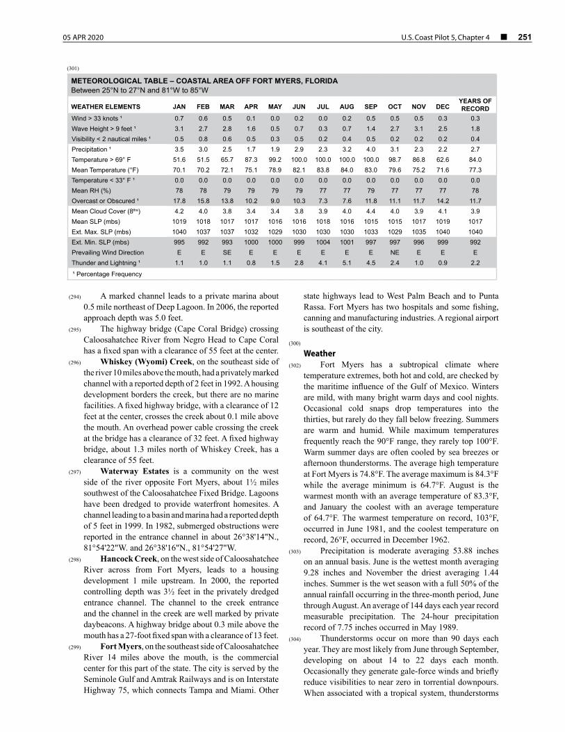
05 APR 2020 U.S. Coast Pilot 5, Chapter 4 ¢ 251
(294) A marked channel leads to a private marina about 0.5 mile northeast of Deep Lagoon. In 2006, the reported approach depth was 5.0 feet.
(295) The highway bridge (Cape Coral Bridge) crossing Caloosahatchee River from Negro Head to Cape Coral has a fixed span with a clearance of 55 feet at the center.
(296) Whiskey (Wyomi) Creek, on the southeast side of the river 10 miles above the mouth, had a privately marked channel with a reported depth of 2 feet in 1992. A housing development borders the creek, but there are no marine facilities. A fixed highway bridge, with a clearance of 12 feet at the center, crosses the creek about 0.1 mile above the mouth. An overhead power cable crossing the creek at the bridge has a clearance of 32 feet. A fixed highway bridge, about 1.3 miles north of Whiskey Creek, has a clearance of 55 feet.
(297) Waterway Estates is a community on the west side of the river opposite Fort Myers, about 1½ miles southwest of the Caloosahatchee Fixed Bridge. Lagoons have been dredged to provide waterfront homesites. A channel leading to a basin and marina had a reported depth of 5 feet in 1999. In 1982, submerged obstructions were reported in the entrance channel in about 26°38'14"N., 81°54'22"W. and 26°38'16"N., 81°54'27"W.
(298) Hancock Creek, on the west side of Caloosahatchee River across from Fort Myers, leads to a housing development 1 mile upstream. In 2000, the reported controlling depth was 3½ feet in the privately dredged entrance channel. The channel to the creek entrance and the channel in the creek are well marked by private daybeacons. A highway bridge about 0.3 mile above the mouth has a 27-foot fixed span with a clearance of 13 feet.
(299) Fort Myers, on the southeast side of Caloosahatchee River 14 miles above the mouth, is the commercial center for this part of the state. The city is served by the Seminole Gulf and Amtrak Railways and is on Interstate Highway 75, which connects Tampa and Miami. Other
state highways lead to West Palm Beach and to Punta Rassa. Fort Myers has two hospitals and some fishing, canning and manufacturing industries. A regional airport is southeast of the city.
(300) Weather
(302) Fort Myers has a subtropical climate where temperature extremes, both hot and cold, are checked by the maritime influence of the Gulf of Mexico. Winters are mild, with many bright warm days and cool nights. Occasional cold snaps drop temperatures into the thirties, but rarely do they fall below freezing. Summers are warm and humid. While maximum temperatures frequently reach the 90°F range, they rarely top 100°F. Warm summer days are often cooled by sea breezes or afternoon thunderstorms. The average high temperature at Fort Myers is 74.8°F. The average maximum is 84.3°F while the average minimum is 64.7°F. August is the warmest month with an average temperature of 83.3°F, and January the coolest with an average temperature of 64.7°F. The warmest temperature on record, 103°F, occurred in June 1981, and the coolest temperature on record, 26°F, occurred in December 1962.
(303) Precipitation is moderate averaging 53.88 inches on an annual basis. June is the wettest month averaging 9.28 inches and November the driest averaging 1.44 inches. Summer is the wet season with a full 50% of the annual rainfall occurring in the three-month period, June through August. An average of 144 days each year record measurable precipitation. The 24-hour precipitation record of 7.75 inches occurred in May 1989.
(304) Thunderstorms occur on more than 90 days each year. They are most likely from June through September, developing on about 14 to 22 days each month. Occasionally they generate gale-force winds and briefly reduce visibilities to near zero in torrential downpours. When associated with a tropical system, thunderstorms
(301)
METEOROLOGICAL TABLE – COASTAL AREA OFF FORT MYERS, FLORIDABetween 25°N to 27°N and 81°W to 85°W
WEATHER ELEMENTS JAN FEB MAR APR MAY JUN JUL AUG SEP OCT NOV DECYEARS OF RECORD
Wind > 33 knots ¹ 0.7 0.6 0.5 0.1 0.0 0.2 0.0 0.2 0.5 0.5 0.5 0.3 0.3 Wave Height > 9 feet ¹ 3.1 2.7 2.8 1.6 0.5 0.7 0.3 0.7 1.4 2.7 3.1 2.5 1.8 Visibility < 2 nautical miles ¹ 0.5 0.8 0.6 0.5 0.3 0.5 0.2 0.4 0.5 0.2 0.2 0.2 0.4 Precipitation ¹ 3.5 3.0 2.5 1.7 1.9 2.9 2.3 3.2 4.0 3.1 2.3 2.2 2.7 Temperature > 69° F 51.6 51.5 65.7 87.3 99.2 100.0 100.0 100.0 100.0 98.7 86.8 62.6 84.0 Mean Temperature (°F) 70.1 70.2 72.1 75.1 78.9 82.1 83.8 84.0 83.0 79.6 75.2 71.6 77.3 Temperature < 33° F ¹ 0.0 0.0 0.0 0.0 0.0 0.0 0.0 0.0 0.0 0.0 0.0 0.0 0.0 Mean RH (%) 78 78 79 79 79 79 77 77 79 77 77 77 78 Overcast or Obscured ¹ 17.8 15.8 13.8 10.2 9.0 10.3 7.3 7.6 11.8 11.1 11.7 14.2 11.7 Mean Cloud Cover (8ths) 4.2 4.0 3.8 3.4 3.4 3.8 3.9 4.0 4.4 4.0 3.9 4.1 3.9 Mean SLP (mbs) 1019 1018 1017 1017 1016 1016 1018 1016 1015 1015 1017 1019 1017 Ext. Max. SLP (mbs) 1040 1037 1037 1032 1029 1030 1030 1030 1033 1029 1035 1040 1040 Ext. Min. SLP (mbs) 995 992 993 1000 1000 999 1004 1001 997 997 996 999 992 Prevailing Wind Direction E E SE E E E E E E NE E E E Thunder and Lightning ¹ 1.1 1.0 1.1 0.8 1.5 2.8 4.1 5.1 4.5 2.4 1.0 0.9 2.2
¹ Percentage Frequency
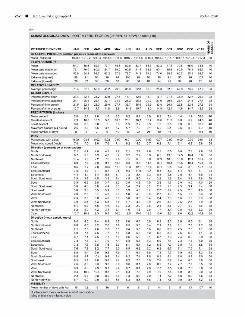
252 ¢ U.S. Coast Pilot 5, Chapter 4 05 APR 2020
(306)
CLIMATOLOGICAL DATA – FORT MYERS, FLORIDA (26°35'N, 81°52'W) 13 feet (4 m)
WEATHER ELEMENTS JAN FEB MAR APR MAY JUN JUL AUG SEP OCT NOV DEC YEAR
YEA
RS
OF
REC
OR
D
SEA LEVEL PRESSURE (station pressure reduced to sea level)Mean (millibars) 1020.3 1019.2 1017.5 1016.6 1015.5 1016.0 1017.8 1016.3 1015.0 1015.7 1017.7 1019.8 1017.3 38 TEMPERATURE (°F)Mean 64.7 65.5 69.7 73.7 78.6 82.0 83.1 83.3 82.3 77.4 70.8 66.0 74.8 40 Mean daily maximum 75.1 76.0 80.3 84.7 89.0 90.9 91.4 91.6 90.1 85.8 80.5 76.3 84.3 40 Mean daily minimum 53.8 54.4 58.7 62.2 67.6 72.7 74.2 74.6 74.0 68.5 60.7 55.1 64.7 40 Extreme (highest) 88 91 93 96 99 103 98 98 96 95 95 90 103 40 Extreme (lowest) 28 32 33 39 52 60 66 67 64 48 34 26 26 40 RELATIVE HUMIDITYAverage percentage 78.4 67.2 50.0 41.2 29.6 35.3 52.8 38.0 25.3 32.0 52.0 73.5 47.9 38 CLOUD COVERPercent of time clear 33.4 32.8 31.2 32.0 27.5 16.1 12.5 14.1 16.7 27.8 31.9 32.7 25.6 38 Percent of time scattered 24.1 25.6 26.4 27.1 31.3 28.3 28.2 30.0 27.9 29.4 26.4 24.3 27.4 38 Percent of time broken 21.5 22.4 23.0 25.0 27.7 33.7 35.5 35.9 33.8 26.1 22.8 22.8 27.6 38 Percent of time overcast 15.7 14.3 14.7 11.8 8.9 14.5 15.7 13.0 14.8 12.4 14.6 14.7 13.7 38 PRECIPITATION (inches)Mean amount 2.0 2.1 2.6 1.6 3.5 9.2 8.9 8.9 8.2 3.4 1.4 1.4 53.8 40 Greatest amount 7.9 10.8 18.5 5.6 10.3 20.1 16.7 16.7 16.6 11.9 8.0 5.2 74.8 40 Least amount 0.0 0.0 0.0 T 0.3 1.9 2.2 3.9 1.9 0.0 0.0 0.0 32.8 40 Maximum amount (24 hours) 2.6 2.6 5.6 3.7 7.7 5.7 7.3 5.1 5.5 6.1 3.6 3.0 7.7 40 Mean number of days 8 8 7 6 10 18 22 21 19 11 7 7 144 40 WINDPercentage with gales 0.00 0.01 0.02 0.02 0.00 0.01 0.00 0.00 0.07 0.00 0.00 0.00 0.01 38Mean wind speed (knots) 7.0 7.5 8.0 7.6 7.1 6.2 5.5 5.7 6.2 7.1 7.1 6.8 6.8 38Direction (percentage of observations)North 7.1 6.7 4.8 4.1 2.8 2.1 2.2 2.6 2.8 6.5 8.0 7.8 4.8 38 North Northeast 8.7 8.0 5.9 4.3 3.7 3.2 2.9 3.9 6.5 13.0 12.5 10.4 6.9 38 Northeast 10.4 9.6 7.2 7.6 7.6 7.5 6.3 8.0 12.9 18.8 16.8 12.1 10.4 38 East Northeast 8.8 7.5 7.9 9.3 10.6 9.8 9.8 11.1 15.1 16.4 13.5 10.4 10.8 38 East 8.5 6.7 7.6 10.5 11.2 10.3 12.2 13.4 14.1 9.5 8.4 8.8 10.1 38 East Southeast 7.0 5.7 7.7 8.7 9.8 9.3 11.5 10.4 9.5 5.3 5.4 6.3 8.1 38 Southeast 4.4 5.1 6.4 5.6 6.1 7.2 8.4 7.3 5.8 2.6 3.5 4.4 5.6 38 South Southeast 3.5 3.9 4.5 3.5 3.4 4.5 5.0 4.4 3.2 1.9 2.4 3.3 3.6 38 South 5.5 6.2 6.5 3.7 3.0 3.8 4.3 4.0 2.8 1.7 3.0 4.0 4.0 38 South Southwest 3.8 4.8 5.8 4.4 3.3 3.4 2.9 3.2 2.3 1.3 2.3 3.1 3.4 38 Southwest 3.0 3.8 5.5 5.9 5.5 5.3 4.8 3.7 2.7 1.9 2.5 2.8 4.0 38 West Southwest 2.0 2.5 3.7 4.6 6.0 5.8 4.0 3.6 2.7 1.9 1.5 1.7 3.3 38 West 2.3 2.9 3.8 4.6 5.5 5.6 3.8 3.4 2.4 2.3 1.6 1.5 3.3 38 West Northwest 3.9 5.1 5.3 5.8 5.8 4.7 3.3 2.9 2.6 3.0 2.5 2.5 3.9 38 Northwest 5.1 6.3 4.8 4.5 3.7 3.2 2.0 2.6 2.1 2.5 2.7 4.0 3.6 38 North Northwest 5.2 5.0 4.2 3.4 2.1 1.9 1.6 2.0 1.7 3.1 3.8 4.6 3.2 38 Calm 10.7 10.3 8.3 9.5 10.0 12.5 15.0 13.5 10.6 8.3 9.6 12.2 10.9 38 Direction (mean speed, knots)North 8.4 8.6 8.4 8.2 6.8 6.6 6.1 6.6 6.9 8.0 8.9 8.5 8.1 38 North Northeast 8.0 8.3 8.2 7.6 7.2 6.5 5.6 6.4 7.1 7.9 8.1 7.8 7.7 38 Northeast 7.1 7.5 7.6 7.3 7.1 6.4 5.8 5.8 6.6 8.0 7.5 7.0 7.1 38 East Northeast 6.9 7.4 7.6 7.7 7.6 6.8 5.8 6.0 6.5 8.0 7.5 6.8 7.1 38 East 6.7 7.1 7.5 7.7 7.5 6.6 5.9 6.1 6.7 7.6 7.4 6.9 6.9 38 East Southeast 7.3 7.6 7.7 7.9 7.1 6.3 6.3 6.3 6.9 7.1 7.3 7.3 7.0 38 Southeast 7.3 7.6 7.8 7.6 6.7 6.1 6.1 6.2 6.5 7.0 7.0 7.4 6.8 38 South Southeast 7.6 7.8 8.2 7.7 6.5 6.5 6.3 6.2 6.8 6.7 7.1 7.5 7.1 38 South 8.9 9.4 9.9 9.2 7.9 7.1 6.4 6.5 7.1 7.7 7.9 8.2 8.2 38 South Southwest 8.8 9.7 10.4 9.8 9.4 8.2 7.4 7.8 8.2 8.1 8.8 9.2 9.0 38 Southwest 8.5 9.1 9.8 9.8 9.4 8.3 7.8 8.0 7.8 8.2 8.4 8.5 8.8 38 West Southwest 7.6 8.3 9.3 9.2 9.6 8.6 8.1 7.8 8.2 7.7 7.7 7.7 8.5 38 West 8.3 8.8 9.3 9.7 9.4 8.7 8.1 7.9 7.7 7.5 7.6 7.6 8.6 38 West Northwest 9.4 10.2 10.4 9.8 9.1 8.4 7.8 7.9 7.9 7.8 8.0 8.8 9.0 38 Northwest 9.3 9.7 9.8 8.9 8.0 7.3 6.9 7.0 7.1 7.2 8.8 9.2 8.6 38 North Northwest 8.7 9.0 9.0 8.1 6.8 6.3 6.5 6.5 7.1 7.6 9.0 8.7 8.2 38 VISIBILITYMean number of days with fog 15 12 13 10 9 6 3 3 4 8 11 13 107 40
T = trace (not measurable) amount of precipitationMiss or blank is a missing value
05 APR 2020 U.S. Coast Pilot 5, Chapter 4 ¢ 253
or showers may produce 6 to 10 inches of rain within 24 hours. While the tropical cyclone season generally lasts from June through November, this area is particularly vulnerable to October hurricanes. However, it was hurricane Donna in September 1960 that brought 80-knot winds to Fort Myers. On the average, Fort Myers can expect hurricane-force winds about once every 12 years.
(305) Winter weather problems are usually the result of cold fronts that work their way down from the north. In addition to dropping temperatures, these fronts can also produce strong, gusty winds and showers. Only rarely do winds reach gale force. Visibilities, which are generally good, are sometimes restricted by a shallow early morning ground fog, which occurs on 3 to 5 winter days per month; this usually dissipates quickly with the rising sun.
(307) Small-craft facilities
(308) There are numerous small-craft facilities on both sides of the Caloosahatchee River in the vicinity of Fort Myers.
(309) Local fishing guides can be obtained as pilots for the adjacent waterways and the Gulf.
(310) Edison Memorial Bridge (U.S. Business Route 41), has two fixed spans that cross the Caloosahatchee River at Fort Myers, Mile 134.5, with a vertical clearance of 56 feet.
(311) Caloosahatchee Bridge (U.S. Route 41), which crosses the Caloosahatchee River about 0.5 mile southwest of the Edison Memorial Bridge has a fixed span with a clearance of 55 feet at the main channel.
(312) Regulated speed zones for the protection of manatees are in the Caloosahatchee River from San Carlos Bay to the Edison Memorial Bridge (U.S. 41) and in Orange River and at its confluence with Caloosahatchee River about 5 miles above Edison Memorial Bridge. (See Manatees, Chapter 3.)
(313) The Okeechobee Waterway is a shallow-draft passage across Florida by way of Caloosahatchee River, Lake Okeechobee, St. Lucie River and the connecting canals. The federal project for the waterway provides for a channel 8 feet deep from Fort Myers to the Intracoastal Waterway near Stuart. Controlling depths are given in Local Notice to Mariners. (See United States Coast Pilot 4, Atlantic Coast, Cape Henry to Key West, for detailed description of the waterway.)
(314) The section of the Intracoastal Waterway from Caloosahatchee River, FL, to Tampa Bay passing through the waters described in this chapter and places along its route is discussed in Chapter 12.
(315) ENCs - US5FL42M, US4FL40M, US5FL49M Charts - 11427, 11426
(316) Matlacha Pass is a shallow body of water extending north from San Carlos Bay to Charlotte Harbor between Pine Island and the mainland. The pass is navigable for drafts of 2 to 3 feet, but the channel, marked by private
daybeacons, is narrow and crooked and has numerous oyster bars. This channel is not recommended without local knowledge as the hydrography in Matlacha Pass is from surveys made before 1900.
(317) About 4 miles above the entrance, the pass is crossed by an overhead power cable with a clearance of 47 feet over the channel and 32 feet over the rest of the pass. State Route 78 highway bridge connects Pine Island, Little Pine Island and West Island with the mainland. The section of the bridge between Little Pine Island and West Island is a 27-foot fixed span with a clearance of 4 feet, and the section of the bridge between West Island and the mainland is a bascule span with a clearance of 9 feet. (See 33 CFR 117.1 through 117.59 and 117.303, Chapter 2, for drawbridge regulations.) An overhead power cable on the south side of the bascule bridge has a clearance of 56 feet. Gasoline, water, ice, marine supplies, launching ramps and some engine repairs can be obtained at the small piers near the bridge.
(318) Bird Island and Givney Key, near the south end of the pass, are part of the Matlacha Pass National Wildlife Refuge.
(319) The coast from San Carlos Bay trends north-northwest to Boca Grande, the entrance to Charlotte Harbor. The barrier islands of Sanibel, Captiva, North Captiva and Cayo Costa are separated from the large Pine Island to the east by Pine Island Sound.
(320) Sanibel Island is a 10-mile hook-shaped island almost tropical in climate and vegetation and with considerable resort development. A large portion of the island is part of the U.S. Department of Interior J.N. “Ding” Darling National Wildlife Refuge. (See Chapter 12.)
(321) Fish havens are 3 to 8 miles southwest of Sanibel Island Light. The outermost fish haven, 8 miles out, is marked by a private buoy.
(322) Blind Pass separates Sanibel Island from Captiva Island. The pass is marked by private daybeacons and is subject to frequent changes. A highway bridge over the pass has a 38-foot fixed span with a clearance of 7 feet.
(323) Captiva Island, about 4 miles long and up to 0.3 mile wide, has considerable resort development.
(324) Redfish Pass, frequently used by fishing vessels, leads into Pine Island Sound from the Gulf between Captiva Island and North Captiva Island. The channel, marked by private buoys and daybeacons, is winding and difficult, with strong currents and frequent changes in depth and position. The pass should not be attempted without local knowledge. A partially submerged groin is on the south side of the pass.
(325) Captiva Pass, leading from the Gulf into Pine Island Sound between North Captiva Island and Cayo Costa, is used to some extent by small fishing vessels. The channel is unmarked and subject to change—local knowledge is required to carry the best water. In 1988, a visible wreck was reported in the entrance channel in about 26°35'00"N., 82°13'30"W. Fair anchorage is available for small boats in Safety Harbor, which is 0.5 mile south of
254 ¢ U.S. Coast Pilot 5, Chapter 4 05 APR 2020
Captiva Pass on the inner side of North Captiva Island. The depth inside the harbor is about 5 feet, but only small craft drawing about 2 feet can enter. The channel into the harbor is marked by private lights and daybeacons, but local knowledge is advised. The holding ground is good, and the anchorage is well protected from all directions.
(326) ENCs - US5FL19M, US4FL40M, US5FL49M Charts - 11425, 11426
(327) Charlotte Harbor, about 60 miles south-southeast from Tampa Bay, is the approach to Port Boca Grande, Boca Grande, Punta Gorda and several smaller settlements. On the south side Charlotte Harbor opens into Pine Island Sound and on the north side into Gasparilla Sound, which are described in chapter 12 in connection with the Intracoastal Waterway. Matlacha Pass, on the south side, has been described earlier in this Chapter.
(328) Prominent features
(329) Port Boca Grande Light (26°43'02"N., 82°15'39"W.), 41 feet above the water, is shown from a white frame dwelling on the south end of the island.
(330) COLREGS Demarcation Lines
(331) The line established for Charlotte Harbor is described in 33 CFR 80.750, Chapter 2.
(332) Vessels should approach the harbor through the
Charlotte Harbor Safety Fairway. (See 33 CFR 166.100 through 166.200, Chapter 2.)
(333) Channels
(334) The federal project for Charlotte Harbor provides for a channel 32 feet deep from deep water in the Gulf to Port Boca Grande. The channel is marked by lighted and unlighted buoys.
(335) A natural channel, marked by lights and daybeacons, leads from deep water at Port Boca Grande through Charlotte Harbor to the mouth of Peace River. In 1982, the reported controlling depth in the channel was 9 feet.
(336) A break in the shoal on the north side of the channel near the south end of Gasparilla Island forms a swash channel which was reported to have a controlling depth of 8 feet in 1982. The best water in this swash channel is about 150 yards off the point, using the end of the fishing pier as a guide.
(337) Anchorages
(338) Vessels should anchor in the Charlotte Harbor Anchorage, on the southwest side of the Safety Fairway. (See 33 CFR 166.100 through 166.200, Chapter 2.) In addition, good anchorage in Charlotte Harbor for large vessels is in depths of 20 to 40 feet at the inner end of the entrance channel; the holding bottom is good. The
anchorage affords excellent shelter from all winds and is used as a harbor of refuge by coasting vessels and others. Small vessels can anchor almost anywhere in Charlotte Harbor. Good depths for small craft can be found close inshore between Port Boca Grande and Boca Grande. Small craft also can use the lagoon at Boca Grande. Another good anchorage for small craft has been reported between Johnson Shoals and the northwest side of Cayo Costa. Depths in the anchorage are 7 to 11 feet, but only craft drawing less than 5 feet can enter through the unmarked swash channel along the northwest side of Cayo Costa.
(339) Dangers
(340) Numerous floating piles have been reported in Charlotte Harbor and adjacent waterways and in Boca Grande Channel and its approaches.
(341) Currents
(342) The tidal currents in the entrance channel average 2.2 knots at strength. The ebb current, that is said to attain occasionally an extreme velocity of 3 to 4 knots, depending also upon the force and direction of the wind. In the harbor channel between Cape Haze and the north end of Pine Island, the average velocity of the current is 0.5 knot. In Matlacha Pass at Little Pine Island bridge the current floods to the southeast with an average velocity of 0.6 knot; the ebb current is weak and variable. To the north at the Myakka River bridges the current floods to the northwest with an average velocity of 0.5 knot; the ebb current is weak and variable. In Peace River the current floods to the northeast and ebbs to the southwest with an average velocity of about 0.4 knot at strength. Predictions of the current at several places in Charlotte Harbor may be obtained in the Tidal Current Tables.
(343) Pilotage, Charlotte Harbor
(344) Pilotage is compulsory for all foreign vessels and U.S. vessels under register in the foreign trade and any oil-carrying vessel. Pilotage is optional for U.S. coastwise vessels that have on board a pilot licensed by the federal government for these waters; however, most commercial vessels take a local pilot. Pilotage is available from Boca Grande Pilots, Inc., Post Office Box 266, Boca Grande, FL 33921, telephone 941–964–2245, FAX (same number). The pilot office monitors VHF-FM channels 16 and 12 about 12 hours before a vessel’s ETA. Pilots board vessels approximately 1 mile seaward of Charlotte Harbor Lighted Buoy 2 (26°40'17"N., 82°18'50"W.). In 1996, due to shoaling channel conditions all vessel movements are in daylight and at slack water. The pilot boat has a blue hull and white and gray superstructure with the name PILOT on transom and bow. The pilot boat monitors VHF-FM channel 12 and works on channel 12. Vessels being boarded should maintain a dead-slow speed and provide a ladder 1 meter (about 3 feet) above the water on the lee side. Pilotage is arranged by telephone
05 APR 2020 U.S. Coast Pilot 5, Chapter 4 ¢ 255
or FAX (both given above), or through ships’ agents. An advance lead-time of 24 hours is requested.
(345) Towage
(346) A small tug is available for light towing jobs.(347)
Quarantine, customs, immigration and agricultural quarantine
(348) (See Chapter 3, Vessel Arrival Inspections, and Appendix A for addresses.)
(349) Quarantine is enforced in accordance with regulations of the U.S. Public Health Service. (See Public Health Service, Chapter 1.)
(350) Boca Grande is a customs port of entry.(351)
Supplies(352) Bunker fuels are not available locally. Limited
amounts of gasoline, provisions and marine supplies are available locally; large amounts require advance notice. Unlimited amounts of ice are available on short notice. Fresh water is available.
(353) Repairs
(354) There are no drydocking or major repair facilities for deep-draft vessels at Port Boca Grande; the nearest such facilities are at Tampa, FL. Small machine-shop repairs are available locally; larger above-the-waterline repairs using portable equipment are available from the mainland on about 4 hours notice. Divers are available on a few hours notice.
(355) A privately marked channel with a reported depth of 5.5 feet leads to a marina on the east side of Charlotte Harbor about 2.6 miles, 088° from Cape Haze Shoal Light 6 (26°45'36"N., 82°06'38"W.). Large and small craft are handled at the marina. Berths with electricity, gasoline, diesel fuel, water, ice, some marine supplies, provisions, wet and dry storage, a surfaced launching ramp and a restaurant are available at the marina. A forklift with a 4.7 ton capacity is available.
(356) ENCs - US4FL40M, US5FL49M Chart - 11426
(357) Riviera Lagoons is a development on Alligator Creek, on the east side of Charlotte Harbor about 14 miles northeast of Boca Grande. Lagoons have been dredged to provide waterfront homesites. A marina has berthage in 6 to 7 feet, and in 1991, there was reported to be 6 feet in the channel leading to the creek. A private light and daybeacons mark the channel. Gasoline, diesel fuel, water, ice and marine supplies are available. There is a launching ramp and a travel lift that can handle craft to 60 feet and 35 tons for hull and engine repairs, or storage. Towing service is available 24 hours a day.
(358) An artificial reef, marked by private daybeacons, is about 2 miles southwest of the entrance to Alligator Creek.
(359) Peace River empties into the head of Charlotte Harbor from northeast. Above Punta Gorda the river is navigable by small outboards with local knowledge as far as Hull, 15 miles above the entrance, but caution is necessary to avoid the snags in the upper reaches. Heavy growths of hyacinth also are found in the upper reaches, which completely block many of the small inlets, bayous and lakes.
(360) The entrance to the river is marked by a light about 1.7 miles west of Mangrove Point. The river channel is marked by a light and daybeacons as far as Long Island just above Cleveland, about 9 miles above the entrance; above that stakes mark the channel.
(361) Port Charlotte is a year-round community on Alligator Bay, on the north side of Peace River 3 miles above the entrance. The town has two hospitals and bus connections.
(362) Punta Gorda, a town on the south side of Peace River, 4 miles above the entrance, has rail connections with points to the north and south. Punta Gorda is a commercial fishing port. The town has a hospital.
(363) A dredged channel leads from the river to a marina at the northwest end of town. The channel is marked by a light and daybeacons. A riprap breakwater protects the northeast and northwest sides of the marina basin. The marina has berths with electricity, gasoline, diesel fuel, water, ice and sewage pump-out.
(364) U.S. Route 41 (Tamiami Trail) highway bridge crossing the river at Punta Gorda has two fixed spans, each with a clearance of 45 feet. The channel span of the former highway bridge close northeast of these bridges has been removed, but the ruins of the north and south approach piers remain and are awash; extreme caution should be exercised in the area. An overhead power cable close northeast of the ruins has a clearance of 75 feet.
(365) A marina, on the south side of the river about 1 mile east of the bridge, has two travel lifts that can handle craft to 60 feet and 35 tons for hull and engine repair or storage. A privately marked channel, with a reported controlling depth of about 3 feet in 2013, leads to the marina.
(366) A municipal marina, about 0.5 mile southeast of the bridge, has berths with electricity, water, ice, pump-out, some marine supplies and a launching ramp. In 2011, the reported controlling depth was 7 feet with 4 to 8 feet in the basin.
(367) Charlotte Harbor is a community at the northwest end of the bridge. A marina on the west side of the bridge can provide gasoline, water, marine supplies and dry storage. Berths are not available. A mobile hoist can haul out craft to 20 tons for hull and engine repairs. In 2002, there was reported to be 3.8 feet of water in the approaches. Intercity bus service is available at Punta Gorda. A Class I railroad provides freight service; air service is available at the county airport.
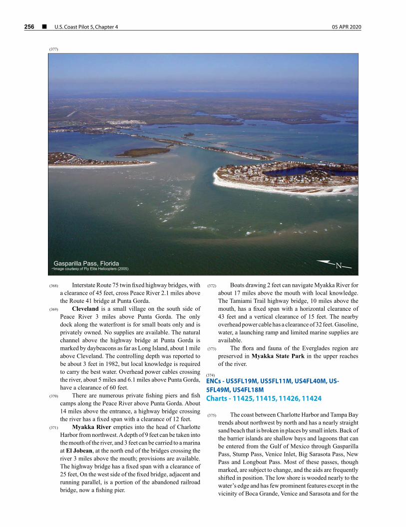
256 ¢ U.S. Coast Pilot 5, Chapter 4 05 APR 2020
(368) Interstate Route 75 twin fixed highway bridges, with a clearance of 45 feet, cross Peace River 2.1 miles above the Route 41 bridge at Punta Gorda.
(369) Cleveland is a small village on the south side of Peace River 3 miles above Punta Gorda. The only dock along the waterfront is for small boats only and is privately owned. No supplies are available. The natural channel above the highway bridge at Punta Gorda is marked by daybeacons as far as Long Island, about 1 mile above Cleveland. The controlling depth was reported to be about 3 feet in 1982, but local knowledge is required to carry the best water. Overhead power cables crossing the river, about 5 miles and 6.1 miles above Punta Gorda, have a clearance of 60 feet.
(370) There are numerous private fishing piers and fish camps along the Peace River above Punta Gorda. About 14 miles above the entrance, a highway bridge crossing the river has a fixed span with a clearance of 12 feet.
(371) Myakka River empties into the head of Charlotte Harbor from northwest. A depth of 9 feet can be taken into the mouth of the river, and 3 feet can be carried to a marina at El Jobean, at the north end of the bridges crossing the river 3 miles above the mouth; provisions are available. The highway bridge has a fixed span with a clearance of 25 feet, On the west side of the fixed bridge, adjacent and running parallel, is a portion of the abandoned railroad bridge, now a fishing pier.
(372) Boats drawing 2 feet can navigate Myakka River for about 17 miles above the mouth with local knowledge. The Tamiami Trail highway bridge, 10 miles above the mouth, has a fixed span with a horizontal clearance of 43 feet and a vertical clearance of 15 feet. The nearby overhead power cable has a clearance of 32 feet. Gasoline, water, a launching ramp and limited marine supplies are available.
(373) The flora and fauna of the Everglades region are preserved in Myakka State Park in the upper reaches of the river.
(374) ENCs - US5FL19M, US5FL11M, US4FL40M, US-5FL49M, US4FL18M Charts - 11425, 11415, 11426, 11424
(375) The coast between Charlotte Harbor and Tampa Bay trends about northwest by north and has a nearly straight sand beach that is broken in places by small inlets. Back of the barrier islands are shallow bays and lagoons that can be entered from the Gulf of Mexico through Gasparilla Pass, Stump Pass, Venice Inlet, Big Sarasota Pass, New Pass and Longboat Pass. Most of these passes, though marked, are subject to change, and the aids are frequently shifted in position. The low shore is wooded nearly to the water’s edge and has few prominent features except in the vicinity of Boca Grande, Venice and Sarasota and for the
Gasparilla Pass, FloridaImage courtesy of Fly Elite Helicopters (2005) N
(377)
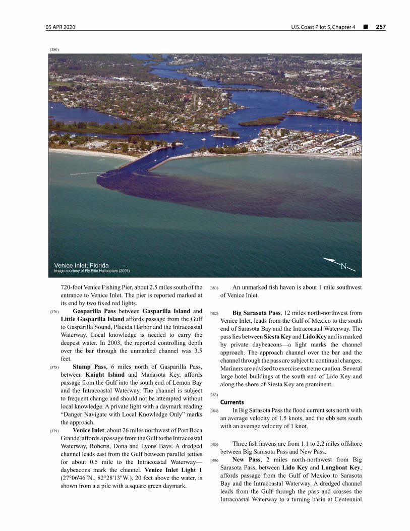
05 APR 2020 U.S. Coast Pilot 5, Chapter 4 ¢ 257
720-foot Venice Fishing Pier, about 2.5 miles south of the entrance to Venice Inlet. The pier is reported marked at its end by two fixed red lights.
(376) Gasparilla Pass between Gasparilla Island and Little Gasparilla Island affords passage from the Gulf to Gasparilla Sound, Placida Harbor and the Intracoastal Waterway. Local knowledge is needed to carry the deepest water. In 2003, the reported controlling depth over the bar through the unmarked channel was 3.5 feet.
(378) Stump Pass, 6 miles north of Gasparilla Pass, between Knight Island and Manasota Key, affords passage from the Gulf into the south end of Lemon Bay and the Intracoastal Waterway. The channel is subject to frequent change and should not be attempted without local knowledge. A private light with a daymark reading “Danger Navigate with Local Knowledge Only” marks the approach.
(379) Venice Inlet, about 26 miles northwest of Port Boca Grande, affords a passage from the Gulf to the Intracoastal Waterway, Roberts, Dona and Lyons Bays. A dredged channel leads east from the Gulf between parallel jetties for about 0.5 mile to the Intracoastal Waterway—daybeacons mark the channel. Venice Inlet Light 1 (27°06'46"N., 82°28'13"W.), 20 feet above the water, is shown from a a pile with a square green daymark.
(381) An unmarked fish haven is about 1 mile southwest of Venice Inlet.
(382) Big Sarasota Pass, 12 miles north-northwest from
Venice Inlet, leads from the Gulf of Mexico to the south end of Sarasota Bay and the Intracoastal Waterway. The pass lies between Siesta Key and Lido Key and is marked by private daybeacons—a light marks the channel approach. The approach channel over the bar and the channel through the pass are subject to continual changes. Mariners are advised to exercise extreme caution. Several large hotel buildings at the south end of Lido Key and along the shore of Siesta Key are prominent.
(383) Currents
(384) In Big Sarasota Pass the flood current sets north with an average velocity of 1.5 knots, and the ebb sets south with an average velocity of 1 knot.
(385) Three fish havens are from 1.1 to 2.2 miles offshore
between Big Sarasota Pass and New Pass.(386) New Pass, 2 miles north-northwest from Big
Sarasota Pass, between Lido Key and Longboat Key, affords passage from the Gulf of Mexico to Sarasota Bay and the Intracoastal Waterway. A dredged channel leads from the Gulf through the pass and crosses the Intracoastal Waterway to a turning basin at Centennial
Venice Inlet, FloridaImage courtesy of Fly Elite Helicopters (2005)
N
(380)
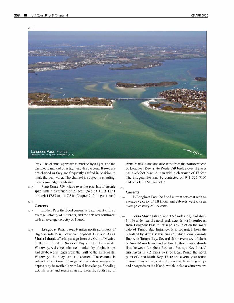
258 ¢ U.S. Coast Pilot 5, Chapter 4 05 APR 2020
Park. The channel approach is marked by a light, and the channel is marked by a light and daybeacons. Buoys are not charted as they are frequently shifted in position to mark the best water. The channel is subject to shoaling; local knowledge is advised.
(387) State Route 789 bridge over the pass has a bascule span with a clearance of 23 feet. (See 33 CFR 117.1 through 117.59 and 117.311, Chapter 2, for regulations.)
(388) Currents
(389) In New Pass the flood current sets northeast with an average velocity of 1.6 knots, and the ebb sets southwest with an average velocity of 1 knot.
(390) Longboat Pass, about 9 miles north-northwest of
Big Sarasota Pass, between Longboat Key and Anna Maria Island, affords passage from the Gulf of Mexico to the north end of Sarasota Bay and the Intracoastal Waterway. A dredged channel, marked by a light, buoys and daybeacons, leads from the Gulf to the Intracoastal Waterway; the buoys are not charted. The channel is subject to continual changes at the entrance—greater depths may be available with local knowledge. Shoaling extends west and south in an arc from the south end of
Anna Maria Island and also west from the northwest end of Longboat Key. State Route 789 bridge over the pass has a 45-foot bascule span with a clearance of 17 feet. The bridgetender may be contacted on 941–355–7107 and on VHF-FM channel 9.
(392) Currents
(393) In Longboat Pass the flood current sets east with an average velocity of 1.8 knots, and ebb sets west with an average velocity of 1.6 knots.
(394) Anna Maria Island, about 6.5 miles long and about
1 mile wide near the north end, extends north-northwest from Longboat Pass to Passage Key Inlet on the south side of Tampa Bay Entrance. It is separated from the mainland by Anna Maria Sound, which joins Sarasota Bay with Tampa Bay. Several fish havens are offshore of Anna Maria Island and within the three-nautical-mile line, between Longboat Pass and Passage Key Inlet. A fish haven is 7.2 miles west of Bean Point, the north point of Anna Maria Key. There are several year-round communities and a yacht club, marinas, launching ramps and boatyards on the island, which is also a winter resort.
Longboat Pass, FloridaImage courtesy of Fly Elite Helicopters (2005) N
(391)

05 APR 2020 U.S. Coast Pilot 5, Chapter 4 ¢ 259