Embed Size (px)
Citation preview
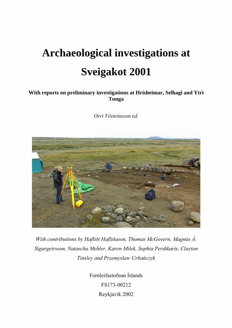
Archaeological investigations at
Sveigakot 2001 With reports on preliminary investigations at Hrísheimar, Selhagi and Ytri
Tunga
Orri Vésteinsson ed.
With contributions by Hafliði Hafliðason, Thomas McGovern, Magnús Á.
Sigurgeirsson, Natascha Mehler, Karen Milek, Sophia Perdikaris, Clayton
Tinsley and Przemysław Urbańczyk
Fornleifastofnun Íslands
FS173-00212
Reykjavík 2002

2
© Fornleifastofnun Íslands 2002.
3
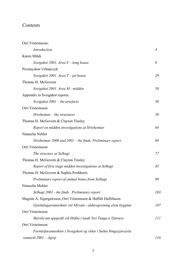
Contents
Orri Vésteinsson:
Introduction 4
Karen Milek
Sveigakot 2001. Area S - long house 8
Przemysław Urbańczyk
Sveigakot 2001. Area T – pit house 29
Thomas H. McGovern
Sveigakot 2001. Area M - midden 50
Appendix to Sveigakot reports:
Sveigakot 2001 – the artefacts 56
Orri Vésteinsson
Hrísheimar – the structures 59
Thomas H. McGovern & Clayton Tinsley
Report on midden investigations at Hrísheimar 64
Natascha Nehler
Hrísheimar 2000 and 2001 – the finds. Preliminary report 69
Orri Vésteinsson
The structure at Selhagi 77
Thomas H. McGovern & Clayton Tinsley Report of first stage midden investigations at Selhagi 83
Thomas H. McGovern & Sophia Perdikaris
Preliminary report of animal bones from Selhagi 90
Natascha Mehler
Selhagi 2001 - the finds. Preliminary report 103
Magnús Á. Sigurgeirsson, Orri Vésteinsson & Hafliði Hafliðason
Gjóskulagarannsóknir við Mývatn - aldursgreining elstu byggðar 107
Orri Vésteinsson
Skýrsla um uppgröft við Höfða í landi Ytri Tungu á Tjörnesi 111
Orri Vésteinsson
Fornleifarannsóknir í Sveigakoti og víðar í Suður Þingeyjarsýslu
sumarið 2001 – Ágrip 116
4
Orri Vésteinsson:
Introduction Thanks to continued support from the Icelandic Research Council (Rannís), NSF and The
National Geographic society excavations continued apace at Sveigakot in 2001. As before the
project was directed by Orri Vésteinsson with Karen Milek supervising the excavation of the
structures in Area S and Tom McGovern supervising the excavation of the sheet midden M.
The Sveigakot team was joined by a contingent from the Polish Academy of Sciences under
the leadership of professor Przemysław Urbańczyk who has undertaken to supervise
excavations of sunken features revealed by midden excavations in 2000 in Area T at the
southwest margins of the site.
While considerable headway was made in 2001 it is becoming more and more clear
that Sveigakot is a site full of surprises, containing much more extensive archaeological
deposits than originally believed. Area S can realistically be expected to be fully excavated in
2002 – the earlier phase of the skáli revealed in 2001 clearly is not predated by any more
structures. Area T has on the other hand been revealed to contain a complex sequence of
sunken featured buildings which clearly will take longer to investigate fully. In 2000
structural evidence was found a short distance south of Area S and in 2001 further evidence of
buried structures was revealed between areas S and T (P). These await investigations which
hopefully will reveal the stratigraphic relationship between the features and deposits in areas
S, M and T. At present it seems clear that the structure in area S is the most recent building at
the site – occupied well into the 12th century. It has an earlier phase which post-dates ~950
and may be contemporary with or later than the midden deposits in area T, which have
radiocarbon dates suggesting they may have been deposited in the early 11th century. They in
turn cap a series of pit houses, the latest of which excavated in 2001 clearly has a long history
of use and repairs. These pit houses are the earliest structural remains so far examined at
Sveigakot and they may be contemporary with the upper midden in area M. Below the tephra
layer, tentatively dated to ~950 AD, there is the lower midden, as yet not associated with any
structural remains, representing the earliest animal bone collection so far excavated in
Iceland.
Based on the incomplete stratigraphic sequence and a number of radiocarbon dates
obtained from areas M, S and T a tentative sequence can be suggested for the site.
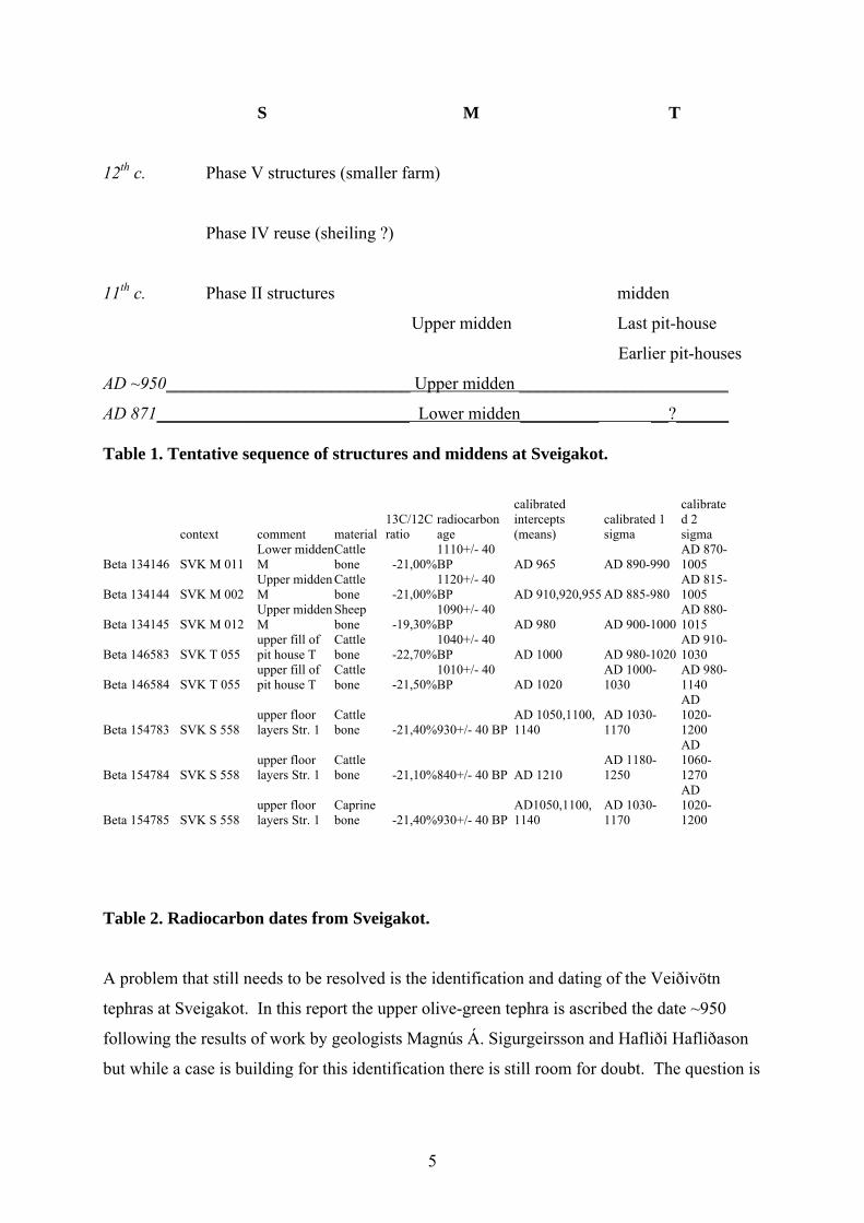
5
S M T
12th c. Phase V structures (smaller farm)
Phase IV reuse (sheiling ?)
11th c. Phase II structures midden
Upper midden Last pit-house
Earlier pit-houses
AD ~950____________________________ Upper midden ________________________
AD 871_____________________________ Lower midden_________ __?______ Table 1. Tentative sequence of structures and middens at Sveigakot.
Table 2. Radiocarbon dates from Sveigakot.
A problem that still needs to be resolved is the identification and dating of the Veiðivötn
tephras at Sveigakot. In this report the upper olive-green tephra is ascribed the date ~950
following the results of work by geologists Magnús Á. Sigurgeirsson and Hafliði Hafliðason
but while a case is building for this identification there is still room for doubt. The question is
context comment material 13C/12C ratio
radiocarbon age
calibrated intercepts (means)
calibrated 1 sigma
calibrated 2 sigma
Beta 134146 SVK M 011 Lower midden M
Cattle bone -21,00%
1110+/- 40 BP AD 965 AD 890-990
AD 870-1005
Beta 134144 SVK M 002 Upper midden M
Cattle bone -21,00%
1120+/- 40 BP AD 910,920,955 AD 885-980
AD 815-1005
Beta 134145 SVK M 012 Upper midden M
Sheep bone -19,30%
1090+/- 40 BP AD 980 AD 900-1000
AD 880-1015
Beta 146583 SVK T 055 upper fill of pit house T
Cattle bone -22,70%
1040+/- 40 BP AD 1000 AD 980-1020
AD 910-1030
Beta 146584 SVK T 055 upper fill of pit house T
Cattle bone -21,50%
1010+/- 40 BP AD 1020
AD 1000-1030
AD 980-1140
Beta 154783 SVK S 558 upper floor layers Str. 1
Cattle bone -21,40%930+/- 40 BP
AD 1050,1100, 1140
AD 1030-1170
AD 1020-1200
Beta 154784 SVK S 558 upper floor layers Str. 1
Cattle bone -21,10%840+/- 40 BP AD 1210
AD 1180-1250
AD 1060-1270
Beta 154785 SVK S 558 upper floor layers Str. 1
Caprine bone -21,40%930+/- 40 BP
AD1050,1100, 1140
AD 1030-1170
AD 1020-1200
6
also being examined by a team from the University of Edinburgh lead by Andrew Dugmore
and their research may yet shed new light on the matter.
By 2001 it had become abundantly clear what enormous difference the additional material
from Sveigakot had made to the understanding of the archaeology of Hofstaðir and to the
objectives of the Landscapes of settlements project. The clear temporal relationship provided
by the two olive green tephras (irrespective of their absolute age) has for the first time in
Icelandic archaeology allowed comparison of two neighbouring sites occupied in the same
period. The results have not only been surprising but also surprisingly important. The
apparently smaller and more marginally located Sveigakot is an older settlement than
Hofstaðir, a fact that has far ranging implications for our understanding of the settlement of
Mývatnssveit and the sequence of events in the process of the landnám. It suggests that
Hofstaðir was not a pioneering settlement which grew to importance as a result of its
seniority, but on the contrary a fundamentally political foundation, an attempt to create a
power base after most of Mývatnssveit had been settled. The signals for social status coming
from Sveigakot are also in some ways unexpected. While the small size of the phase V skáli
seems to be consistent with the marginal location of the site, the artifact and animal bone
assemblages suggest little or no difference in status from Hofstaðir. This is no doubt partly
explained by the fact that the animal bones and large parts of the artifact assemblage come
from the middens in areas M and T which are – at least in part – significantly earlier than the
structures in Area S. The earliest midden deposits suggest that Sveigakot started out as a very
“healthy” farm, with many pigs and a high cattle to sheep ratio. Unlike Hofstaðir Sveigakot
seems then to have set out on a course of gradual decline until its eventual abandonment in
the 12th century.
These results raise a number of new questions, some of which may be best answered
by looking at more sites from the same period. In 2001 it was decided to put test trenches in
three potential sites in order to see if they are from the Settlement period/Viking age and if
they merit further investigations. Two sites in Mývatnssveit had been identified as possible
early settlements during the regional survey that was carried out in 1996-1999 and one coastal
site in Tjörnes had been identified during a regional survey there in 1999. The site in Tjörnes
turned out not to be a settlement site at all but the other two, Selhagi and Hrísheimar, are
clearly medieval with occupation levels dating to the Viking age as well as the high middle
ages. Both sites have large and well preserved bone assemblages which were partially
excavated in 2001. The results of the analysis of the bone assemblage from Selhagi are
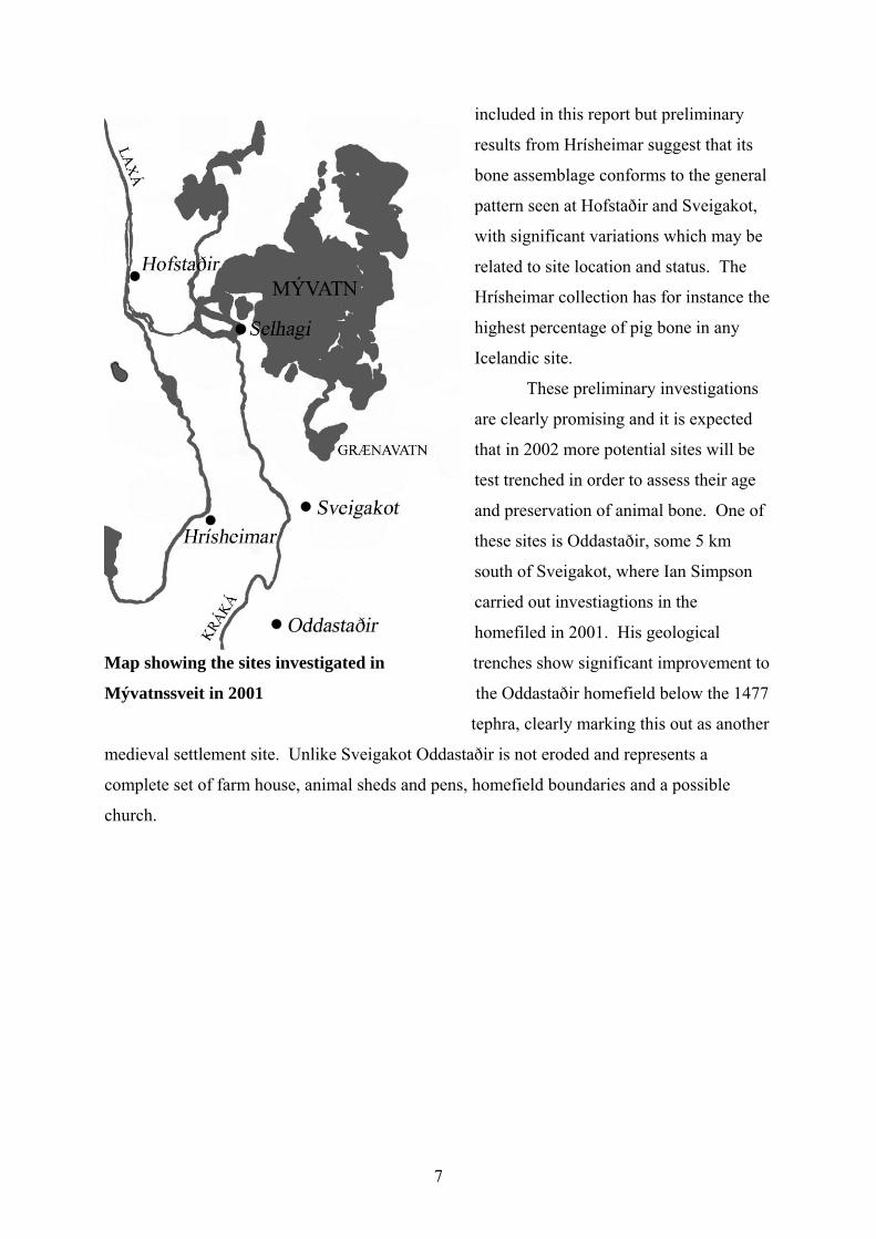
7
included in this report but preliminary
results from Hrísheimar suggest that its
bone assemblage conforms to the general
pattern seen at Hofstaðir and Sveigakot,
with significant variations which may be
related to site location and status. The
Hrísheimar collection has for instance the
highest percentage of pig bone in any
Icelandic site.
These preliminary investigations
are clearly promising and it is expected
that in 2002 more potential sites will be
test trenched in order to assess their age
and preservation of animal bone. One of
these sites is Oddastaðir, some 5 km
south of Sveigakot, where Ian Simpson
carried out investiagtions in the
homefiled in 2001. His geological
Map showing the sites investigated in trenches show significant improvement to
Mývatnssveit in 2001 the Oddastaðir homefield below the 1477
tephra, clearly marking this out as another
medieval settlement site. Unlike Sveigakot Oddastaðir is not eroded and represents a
complete set of farm house, animal sheds and pens, homefield boundaries and a possible
church.
8
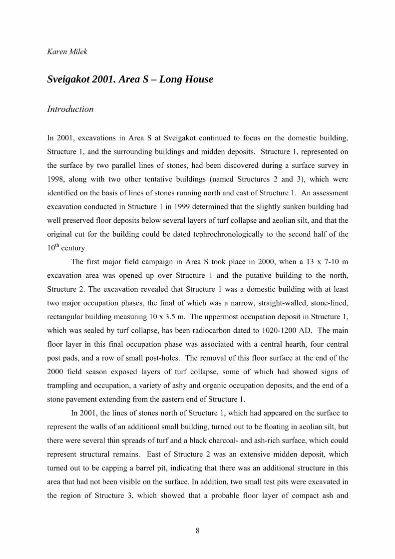
Karen Milek Sveigakot 2001. Area S – Long House Introduction
In 2001, excavations in Area S at Sveigakot continued to focus on the domestic building,
Structure 1, and the surrounding buildings and midden deposits. Structure 1, represented on
the surface by two parallel lines of stones, had been discovered during a surface survey in
1998, along with two other tentative buildings (named Structures 2 and 3), which were
identified on the basis of lines of stones running north and east of Structure 1. An assessment
excavation conducted in Structure 1 in 1999 determined that the slightly sunken building had
well preserved floor deposits below several layers of turf collapse and aeolian silt, and that the
original cut for the building could be dated tephrochronologically to the second half of the
10th century.
The first major field campaign in Area S took place in 2000, when a 13 x 7-10 m
excavation area was opened up over Structure 1 and the putative building to the north,
Structure 2. The excavation revealed that Structure 1 was a domestic building with at least
two major occupation phases, the final of which was a narrow, straight-walled, stone-lined,
rectangular building measuring 10 x 3.5 m. The uppermost occupation deposit in Structure 1,
which was sealed by turf collapse, has been radiocarbon dated to 1020-1200 AD. The main
floor layer in this final occupation phase was associated with a central hearth, four central
post pads, and a row of small post-holes. The removal of this floor surface at the end of the
2000 field season exposed layers of turf collapse, some of which had showed signs of
trampling and occupation, a variety of ashy and organic occupation deposits, and the end of a
stone pavement extending from the eastern end of Structure 1.
In 2001, the lines of stones north of Structure 1, which had appeared on the surface to
represent the walls of an additional small building, turned out to be floating in aeolian silt, but
there were several thin spreads of turf and a black charcoal- and ash-rich surface, which could
represent structural remains. East of Structure 2 was an extensive midden deposit, which
turned out to be capping a barrel pit, indicating that there was an additional structure in this
area that had not been visible on the surface. In addition, two small test pits were excavated in
the region of Structure 3, which showed that a probable floor layer of compact ash and
9
charcoal was located to the south of, but not to the north of, the row of stones. The
excavation in 2000 therefore revealed that Area S was the site of a complex of buildings
belonging to three or more phases, the sizes, relationships and in some cases the functions of
which, remained to be determined.
The excavation of Area S continued in 2001, with the goal of clarifying these
problems. In addition, there remained a number of broader questions about the site that could
only be answered with further investigation of the structural remains. The first of these issues
was the status of the site. It is clear from both the faunal assemblage and the structural
remains that Sveigakot was a permanently occupied farm, and a comparison of the faunal and
artefactual assemblages with those from Hofstaðir and other settlement sites suggests that the
farm was not particularly impoverished. Nevertheless, Structure 1 is a very small domestic
building by Icelandic standards, and it is possible that earlier phases of the building were
significantly larger, in addition to being a part of complex of contemporaneous structures.
The changing size and numbers of buildings could give an indication of the changing status of
the farm. Also, it was clear that Structure 1 had gone through a number of phases of
rebuilding, and further excavations would clarify whether these phases were part of a
continual process of occupation, or whether they represented periods of site abandonment. If
there were periods when the main dwelling structure went out of use, it is also possible that
the site was used as a shieling between major occupation phases, and further excavation was
required to clarify this. More information about the functions, phases and dates of the
buildings, and the relationships between them, would therefore provide important insights
into the changing function and economic status of the site, as well as an understanding of the
environmental changes that took place in this region between the 9th and 12th centuries, and
the affect of these changes on human activity in the area.
Methodology
In order to fully expose the earlier phases of Structure 1 (Structure 4), as well as Structures 2
and 3, and the building associated with the barrel pit (Structure 5), Area S was extended in all
directions to encompass a total of 21 x 12 m, or 252 m2. As before, the excavation strategy
involved the removal of all soil and sediment by hand and the use of single context recording.
Occupation deposits and midden deposits were sampled and the remainder dry sieved on site
with 4 mm mesh. All of the contexts excavated in 2001 are summarised in Table 1, while
10
some of the contexts referred to in this report were excavated in 2000, and are summarised in
an earlier report.1 This interim report presents the results of the excavation in a sequence of
phases from the most recent to the earliest, and it should be noted that, in the light of the new
excavation results, the numbers of these phases differ slightly from the sequence outlined in
the interim report for 2000. The phases outlined in this report should still be considered
preliminary, and can be applied only to Area S.
Excavation Results
Phase VII: Natural aeolian accumulation from the 12th century to the present. After its
abandonment, Area S was covered with a series of windblown sand and silt deposits
(contexts 549-551, 571-573, 677, 683, 685, 708, 746). These consisted of medium to dark
brown very fine sandy silt, and were often very homogenous and easily distinguished from
the occupation deposits below. The occasional charcoal fragment or artefact – such as the
gaming piece found in context 685, or the spindle whorl fragment found in context 708 – in
these otherwise homogenous layers, indicates a degree of working of the sediments by
cryoturbation and/or bioturbation. These aeolian deposits were thickest in the slight
depression within the sunken-featured building, Structure 1, and south of its southern long
1 Milek, K. (2001) Area S Interim Report. In O. Vésteinsson (ed.), Archaeological Investigations at Sveigakot 1998-2000. Unpublished excavation report No. FS134-00211. Reykjavík: Fornleifastofnun Íslands.
11
wall. Elsewhere, they had been seriously eroded by the wind, which has unfortunately meant
that no tephra layers survive above the archaeological deposits in Area S. Deflation has been
especially drastic in the region of Structure 3, at the top of the low rise on which the ruins are
situated, where loose, sandy aeolian deposits and sparse vegetation sit directly on top of the
yellow, silty subsoil and the dark grey and black tephras of the Landnám tephra sequence.
Down-slope erosion in addition to the wind has also truncated the aeolian silts and
archaeological deposits on the western edge of the low rise.
Phase VI: Site abandonment and structural collapse in the 12th century. During the late
12th century, Structures 1 and 2 were abandoned, and their roofs and walls collapsed. The
area within and around Structure 1 was covered by various layers of turf collapse, most of
which were excavated in 2000 (contexts 554-557, 575, 585, 590; see Milek 2001). Two of
these layers had extended past the edge of the excavation in 2000, and were completed in
2001. The southern edge of turf collapse 554 was excavated as context 724 – a dark brown
fine sandy silt containing lenses of reddish oxidised iron and dark grey tephra. The western
extent of context 590, which probably represents the collapse of the eastern wall of Structure
1, was excavated in 2001 as context 728, which also contained dark grey tephra in reddish to
dark brown very fine sandy silt. Abutting the northern side of the collapsed north long wall of
Structure 1 (context 607) were several small dumps of turf that were distinguished on the
basis of colour and organic content (contexts 603, 605, 739, 741).
North of Structure 1, in the region of the putative Structure 2, were three layers of turf
collapse overlying a black, laminated layer that may represent a floor deposit (context 646;
see Phase V, below). Over the eastern edge of the black deposit was a layer of very dark
greyish brown and reddish turf collapse, which was excavated in 2000 (context 576). Over
the western edge of the black deposit, aligned north-south on the edge of the low mound, was
a layer of dark brown turf containing grey tephra (possibly the ~950 AD tephra) and the black
tephras of the LNL sequence (context 710). Overlying the central part of the black deposit
was very distinctive layer composed of firm, reddish, orange and cream-coloured peaty or
very organic turf (context 577). The excavation of this context began in 2000, but it extended
to the western edge of the excavation, and was completed in 2001. The colour and
composition of this deposit is very like context 556, a peaty turf layer above the floor within
Structure 1 (excavated in 2000), context 682, which capped the paved floor within Structure 3
(see Phase III, below), and context 721 in Area T, which was above the floor within the pit
house, all of which are thought to represent roof collapse. This interpretation, which should
12
also be applied to context 577, is based on the recurring position of these peaty turf layers
immediately above the floor layers, and the fact that they are within the centre of the
buildings only. This is a pattern that has been observed in 19th century turf houses, where the
roof tends to be the first structural component to collapse; it falls into the building and is
confined by the still standing walls. If the interpretation of these distinctively organic turf
layers is correct, it must be significant that they were recurrently chosen as roofing material.
Perhaps the wettest turf available was chosen for the roof due to the fact that the dense root
mat, and the higher proportion of organic matter relative to silt or sand, would make the turf
more impermeable to rain water.
Phase V: Occupation of Structures 1 and 2 in the 11th and 12th centuries. Radiocarbon
assays on sheep and cattle bone found in the uppermost occupation deposit in Structure 1
(context 558) have confirmed that the building was in use until the mid- to late-12th century.2
The central floor layer, a finely laminated black deposit containing abundant soot, charcoal,
and humified organic staining, was excavated at the end of the field season in 2000 (context
559; for a detailed description of this context and the occupation deposits that overlay it, see
Milek 2001). In 2001, the excavation of this phase of the building continued, with the
removal of coterminous occupation deposits immediately north of the central floor layer, and
therefore just outside of the main area of traffic in the centre of the building. Between and
north of the central post pads on the northern edge of context 559 (context 656 b and c), was a
thin lens of firm, compacted light brown silt, and yellowish brown and pinkish brown organic
matter, which may represent a deposit of hay or straw (context 653). Slightly overlapped by
this layer was a small occupation deposit that had accumulated on the north side of post pad
565 b, a dark brown silty sand containing bone charcoal and an iron nail (context 810). On
the northern edge of the building, abutting the northern long wall, was a firm layer of
yellowish brown sandy silt that contained some pieces of charcoal (context 805).
2 Cal AD 1020-1200 at 2 Sigma range, on a Bos t. neonatal phalanx 2 (Beta 254783); Cal AD 1060-1080 and 1150-1270 at 2 sigma range, on a Bos t. neonatal phalanx 2 (Beta-154784); Cal AD 1020-1200 at 2 sigma range, on Ovis/capra rib (Beta-154785).
13
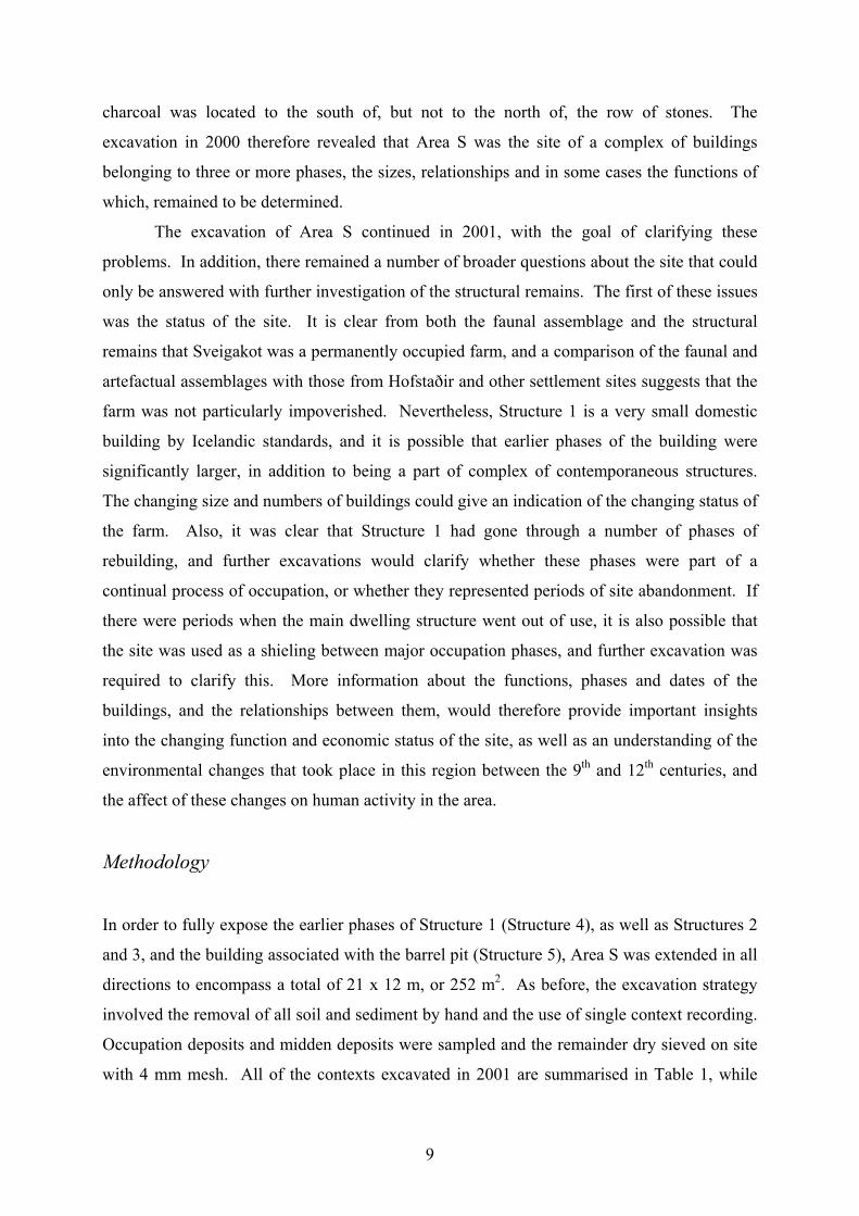
The earliest occupation of
Structure 1 took place on top of
context 611. This layer extends over
most of the eastern and southern parts
of the building, and is primarily
composed of mixed brown turf and
windblown silt, with patches of
lighter pinkish brown organic matter,
occasional charcoal flecks, and small
lenses of black soot or humified
organic staining. The original
deposition of this layer can be
attributed to the collapse of the
earlier phase of this building,
Structure 4, and will be discussed
again under Phase III, below.
However, the layer had clearly been
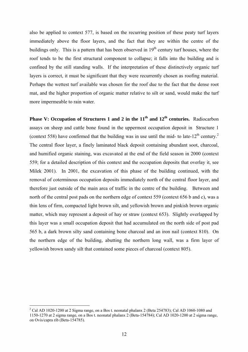
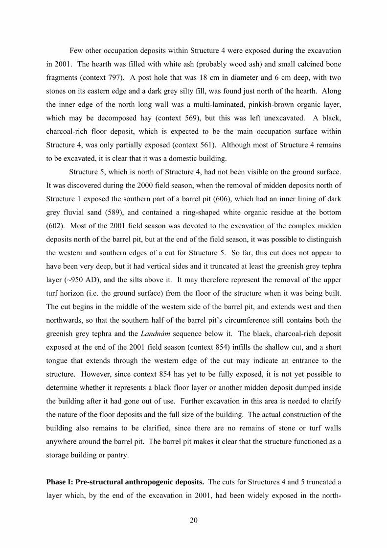
Figure 2. Earlier Hearth, context 642. trampled during the later re-
occupation of the building, prior to the accumulation of the black floor deposit, context 559.
It contained more than the usual number of artefacts, including a whetstone, a bone pin, small,
engraved copper alloy fitting, and iron objects, all of which can be attributed to this phase.
The excavation of this phase was completed in 2001, with the removal of the structural
elements that had been installed prior to the re-occupation of the structure as a domestic
building. Hearth 669, a rectangular hearth with a V-shaped section, had been constructed of
flat basalt stones leaning back against the upright stones of an earlier hearth (context 796; see
Phase II, below). A shallow rectangular cut measuring 130 x 50 cm had been placed around
the south and east sides of the earlier hearth (context 803), and the tilted stones had been
supported with rounded cobbles packed around the outside. All of these stones had then been
packed in, and the cut infilled, with a mixture of yellowish brown silt and ash that may have
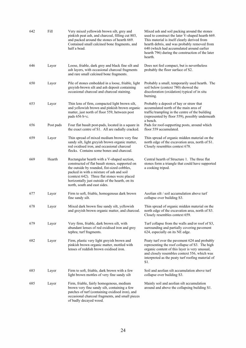
originally been the debris accumulated around the earlier hearth (context 642; see Fig. 2).
This mixed packing material contained small calcined bone fragments and a broken bead.
Three flat stones had then been placed on the north, south and east sides of the hearth,
forming a triangle that could have been used to support a cooking tripod.
14
Other internal structural elements removed during the excavation in 2001 were the
four central post pads that were radially cracked and had clearly borne roof-supporting posts
(context 656 a-d). In addition, there were a series of small post impressions, which appeared
to have been formed by the accumulation of the black floor deposit 559 around timber posts
resting directly on top of, or penetrating very shallowly into, the ground surface (contexts
597, 593, 621, 626, 638, 667). A row of stones placed between post pads 656 b and c, and
which had been slightly overlapped by floor deposit 559 on its northern edge, may delineate
the location of a bench or some other type of furniture. Two of these stones were embedded
in a small deposit of dark brown fine sandy silt (context 807). Finally, the remains of the
southern long wall of Structure 1 were removed (context 609). This consisted of a single
course of stones, 10 m long, that was slightly disturbed and discontinuous, and had clearly
been damaged by erosion or some other disturbance. These stones probably represent the
inner lining of a turf wall that has since eroded away. The stones rested directly on top of an
accumulation of aeolian sand and turf collapse, and their weight had created depressions in
the soft sediments (contexts 610, 778 and 817; see Phase III, below).
Abutting the north long wall of Structure 1, and therefore later than the construction of
that wall, was a deposit that may represent the floor layer of Structure 2 (context 646). This
deposit, which extended approximately 3.7 x 1.7 m, was composed of alternating layers of
fine charcoal/soot and dark brown silt mixed with ash, charcoal and small fragments of burnt
and unburnt bone. Although the composition of context 646 would suggest that it was a floor
surface, the deposit was fairly loose rather than compact, and an alternative interpretation is
that it was a midden deposit associated with the occupation of S1. In order to obtain as much
information as possible about the composition and structure of context 646, and to help clarify
its interpretation, the deposit was excavated in opposing quarters, and was extensively
sampled for micromorphological and bulk sedimentary analyses. Whether this layer is to be
understood as a midden or a floor deposit, it had accumulated on a fairly uneven surface
(context 658), and over a small pit of unknown function (context 745), which contained slag
and charcoal at the bottom and was otherwise filled with homogenous yellowish brown silt.
A series of midden deposits east of Structure 2 and north of Structure 1 are also
thought to be contemporary with the occupation of these buildings. The midden deposits
infilled and capped Structure 5 and its associated barrel pit, which will be discussed further
under Phase II, below. The largest and most heterogeneous midden layer excavated in 2000,
context 579, was split in 2001 into its component layers of charcoal, ash, turf, decomposed
organic matter, sand, stones and fire-cracked rock, many of which were themselves fairly
15
heterogeneous (contexts 690, 692, 695, 760, 767, 806, 812, 814, 819, 820, 825, 827, 828).
These midden layers were 100% dry sieved, and produced the largest assemblages of
charcoal, bone, burnt bone and artefacts in Area S, including loom weights, a whetstone, an
iron nail, and a copper alloy fitting. This material is interpreted as domestic waste, and is
most likely to have accumulated during the occupation of Structure 1 and putative Structure 2.
Phase IV: Use of the domestic structure between major occupation phases. Between the
major occupation phases represented by Structures 1 and 4 respectively, a number of deposits
accumulated, which indicate that the building, or the ruins of the building, were occasionally
used for some type of domestic activity. All of the deposits associated with this phase are
restricted to a small space north and east of the earlier hearth, 796, while the entire southern
half of the building contained only turf collapse and aeolian deposits associated with the
earlier abandonment and collapse of Structure 4 (see Phase III, below). There is no evidence
of turf collapse or aeolian accumulation along the inner edge of the north long wall, and it
may be assumed that this wall remained basically intact throughout the use of both Structures
1 and 4, and provided shelter, or the means of constructing a temporary shelter, for the
intervening period. It is therefore possible that during this intervening phase, the ruins were
used as a temporary shelter or shieling.
Two contexts exhibited evidence of in situ burning in the form of reddened soils,
which had been altered by exposure to heat and oxidising conditions. Context 780, on the
north side of the earlier hearth 796, was a small, rounded patch of burnt soil below a pile of
stones embedded in light greyish brown silt, ash and charcoal (context 650). This feature is
believed to have been a small hearth. It had been abandoned and collapsed before the re-
occupation of the structure, and although it had later been covered by the floor deposit 559,
some of the stones of context 650 had protruded through the floor. Approximately 2 m east of
the earlier hearth, was a deposit of soft greyish brown and yellowish brown ash and charcoal
(826), which infilled a shallow cut (813) that had been made through the mixed turf collapse
and aeolian silt of context 611. This ashy deposit is also thought to represent an ad hoc hearth
rather than a dump, since the sediment below it and surrounding its edges showed the
reddening typical of in situ burning in oxidising conditions.
Above context 826 were a series of small, thin occupation deposits consisting of
brown and yellow silt containing charcoal and a few bone fragments (823), reddish brown
organic matter (822) and mixed ash and charcoal (821). Just east of the hearth was another
series of small, thin occupation deposits that had ultimately been sealed by floor 559 during
16
the later occupation of the building. These deposits consisted of dark reddish brown organic
matter (809), charcoal-stained silt and a white organic residue (816), fine dark brown sand
(815) and ash and charcoal (811). This phase also contained a couple of discrete turf dumps
closer to the eastern end of the building (contexts 616 and 617), one of which had been
capped by a small dump of mixed turf, ash and charcoal (763). There is some evidence for
the accumulation of homogenous aeolian silt and sand prior the restructuring of the building
and the re-occupation of Structure 1 (context 818).
Phase III: Abandonment and collapse of Structures 3, 4 and 5. Following the earlier
occupation phase in Area S (Phase II), there was a period of structural collapse marked by the
accumulation of turf debris and aeolian silts and sands. The most extensive layer made up of
mixed turf collapse and wind blown silt, context 611, was located within Structure 1. As
discussed above, it was subsequently cut for the construction of a temporary hearth during
Phase IV, and later used as the primary occupation surface for Structure 1. Below and west of
context 611, within Structure 1, were other layers of turf collapse belonging to this phase,
which have yet to be excavated (contexts 643 and 867). On the southern edge of Structure 1,
and below its southern long wall (609), was a layer of medium brown aeolian silt and very
fine sand with occasional patches of pinkish brown organic matter and the rare charcoal
fragment (context 610). This layer was generally more sterile than context 611, but
frequently had an indistinct boundary with it, and the two layers may have had similar origins.
Below context 610, but continuing to follow the line of the later wall, were two
coterminous layers of turf collapse. To the west was context 778 – reddish turf containing
greenish grey tephra, which grew increasingly sandy towards its eastern end. To the east was
context 817, which consisted of very sandy brown turf containing greenish grey tephra, lenses
of yellowish brown and pinkish brown organic matter, and some charcoal flecks. These two
layers of turf debris are thought to represent the collapse of an earlier building in the same
general location as Structure 1 (Structure 4), and may themselves represent two different
phases of building construction. Why the extent of these layers remained so confined to the
extent of the later stone wall 607 is not certain. For some time it was believed that they might
have represented packing or levelling material intentionally deposited prior to the
construction of the later wall. However, the soft, sandy nature of these layers makes this
hypothesis unlikely, and it is more plausible that their southern extent has been somewhat
truncated by erosion or human activity. One small dump of mixed turf debris with occasional
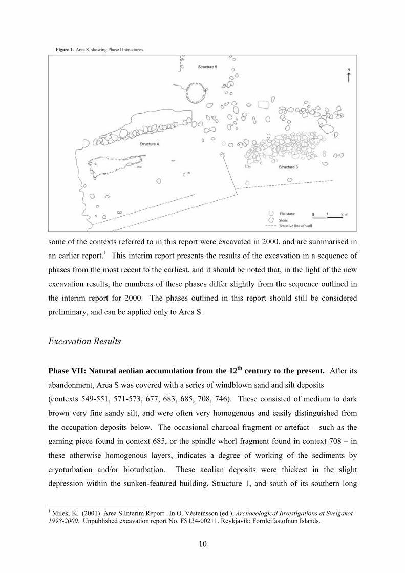
charcoal flecks lapped up against the south side of the turf layer 778. There
17
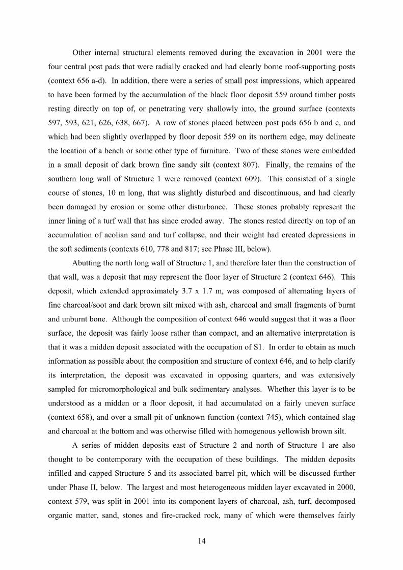
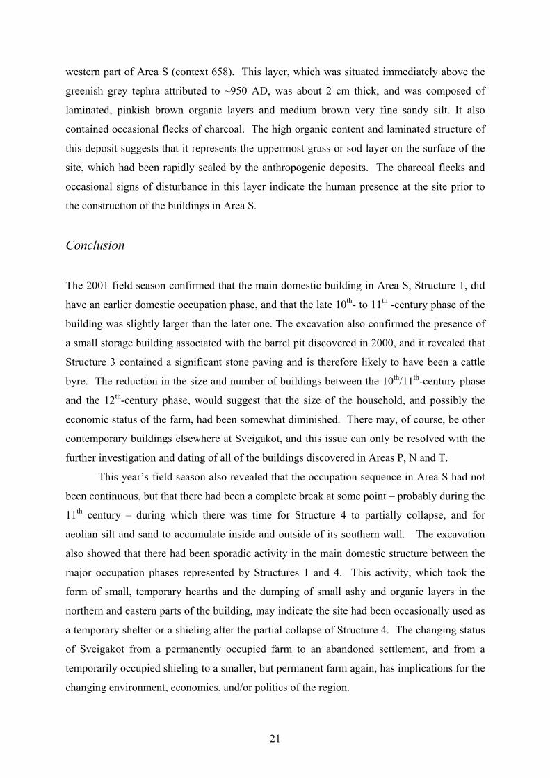
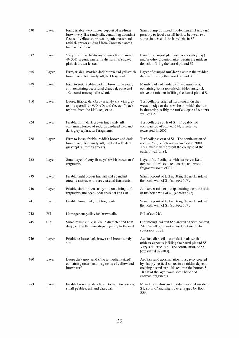
Figure 3. Pavement, context 624.
are a number of turf collapse and silt deposits south of these layers that have yet to be fully
excavated and understood.
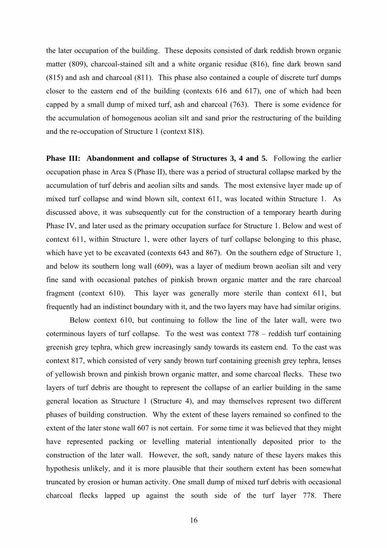
To the east of Structure 4, the collapse of Structure 3 left several layers of turf debris
scattered over and around the stone paving and floor deposits. Most of the stone paving was
capped by contexts 625 (excavated in 2000) and the continuation of this context, 682
(excavated in 2001). This was a very distinctive layer, consisting of firm, plastic, red and
cream-coloured peaty or very organic turf. Like the other peaty turf deposits found capping
interior floor deposits in Structures 1, 2, and the pit house in Area T, this layer is interpreted
as the collapsed roofing material. Context 679, a layer of dark brown turf collapse with lenses
of oxidised iron and grey tephra, surrounded and partially overlapped the edges of the stone
pavement (context 624; see Phase II, below), and is thought to represent the remains of the
turf walls of Structure 3. The removal of context 679 revealed a number of other turf debris
layers belonging to this phase, the excavation of which will continue in 2002.
18
Phase II: Occupation of Structures 3, 4 and 5 in the late 10th and 11th centuries. At the
end of the excavation in 2001, the structures belonging to this phase had only been partially
exposed, and the relationships between them are not yet fully understood. Nevertheless, it is
possible to make a few preliminary comments about the size of the buildings, their function,
and some of the key features within them.
Structures 3 and 4 meet at the very top of the low rise on which the ruins are situated,
and from there the floor of Structure 3 slopes downwards very gently towards the east. The
central feature of this floor is the impressive stone pavement (context 624), which is 5 m long
and just a little over 1 m wide, and is oriented east-west. The pavement was constructed
mainly of flat basalt and lava stones, but also some smaller, subrounded stones, all of different
sizes, which were fitted together to create a fairly even surface. There is a black, charcoal-
rich and ashy floor deposit associated with this pavement, which has so far only been exposed
on the north and east sides of it (context 676). On the south side of the pavement there are
still several layers of turf collapse to be removed, but since there is a stone-free space 1.5 m
wide on the south side of the pavement, as there is on the north side, it is highly likely that the
floor deposit extends to the south side of the pavement as well (see Fig. 1). These stone-free
spaces must have been intentionally cleared, since the natural yellowish brown subsoil that
has been exposed in the north-eastern and south-eastern corners of Area S contains an
abundance of subrounded stones (context 675). The row of stones that had been visible on the
surface of the ground since 1998 are, in fact, all that remains of the north wall of Structure 3.
This wall is on a slightly different angle from the north wall of Structures 4 and 1, tilting
slightly south of grid east, but is nevertheless an extension of the same linear feature. No line
of stones remains on the south side of Structure 3, but the stone-free clearing around the
pavement gives an indication of where the southern wall might have been, and therefore the
dimensions of the building. It appears to have been approximately 7 m long by 5 m wide.
This building may have been a cattle byre, but this will have to be verified in 2002, when the
floor is completely exposed, and its composition can be studied in further detail.
Structure 4 is an earlier building phase of Structure 1, and appears to have been
slightly larger. The same cut (context 645) and north long wall (context 607) were used for
both buildings, but the south long wall of the earlier structure, as shown by the southern limit
of a blackened occupation surface (context 648; only partially exposed) appears to have been
one metre further south. This south wall has yet to be clearly defined, but a series of turf
collapse layers situated 4-5 m from, and parallel to, the north wall, are likely to have been
derived from the collapse of this wall. Likewise, Structure 4 seems to have extended further
19
to the west than Structure 1.
Erosion has truncated the western
edge of the mound, and a charcoal-
rich layer that may be a floor has
been exposed on the erosion face
(context 716).
Only a few of the
occupation deposits within
Structure 4 were exposed during the
2001 field season. So far, the most
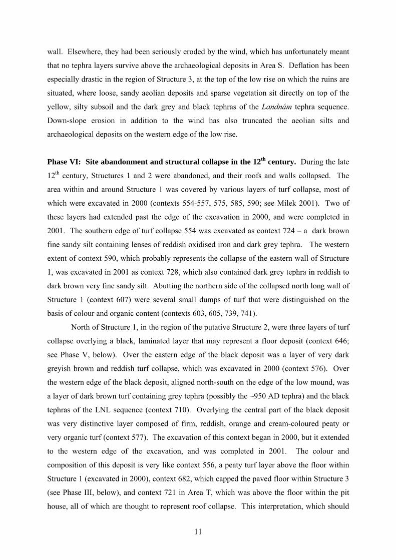
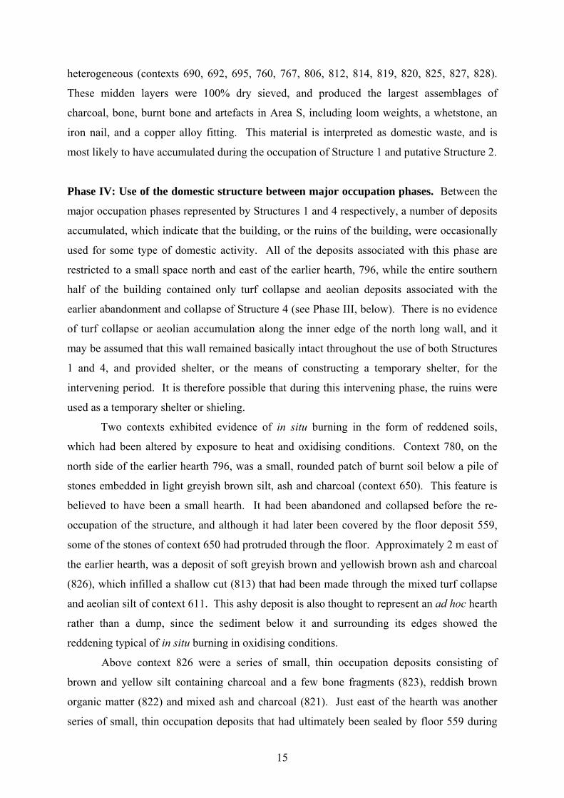
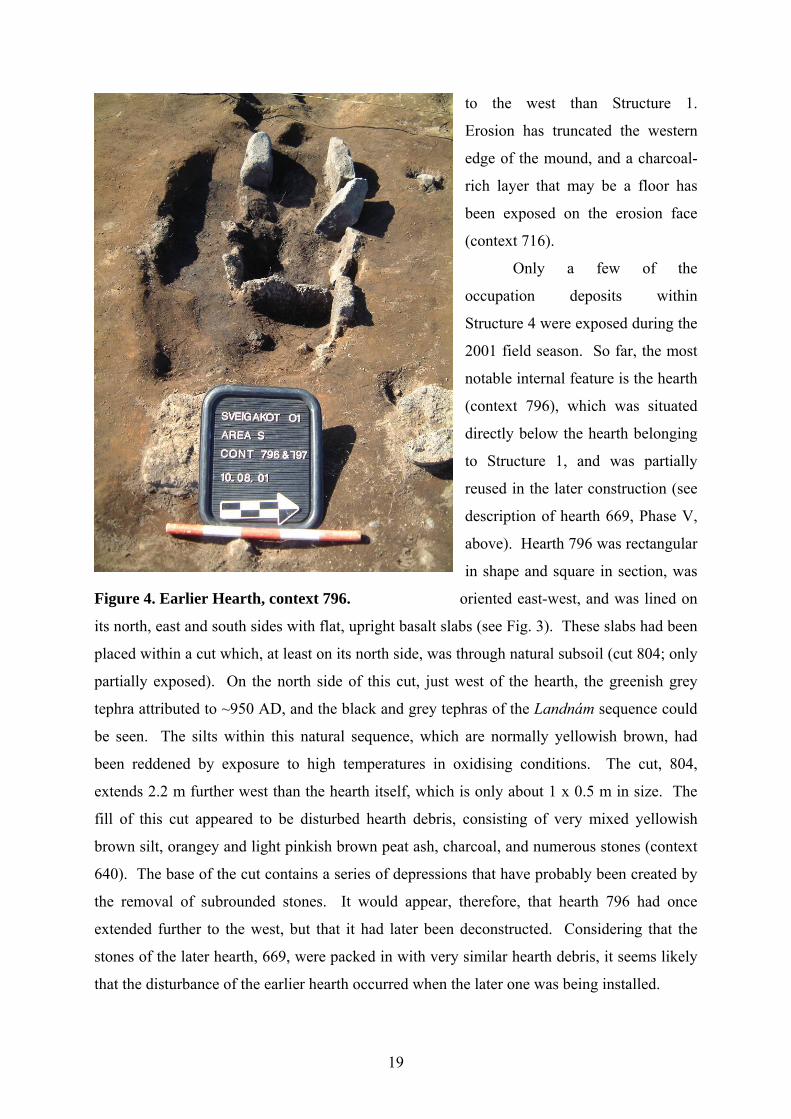
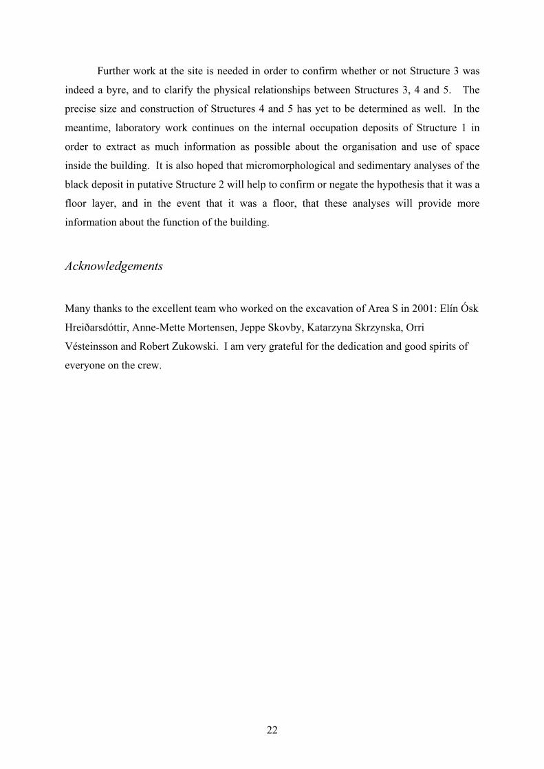
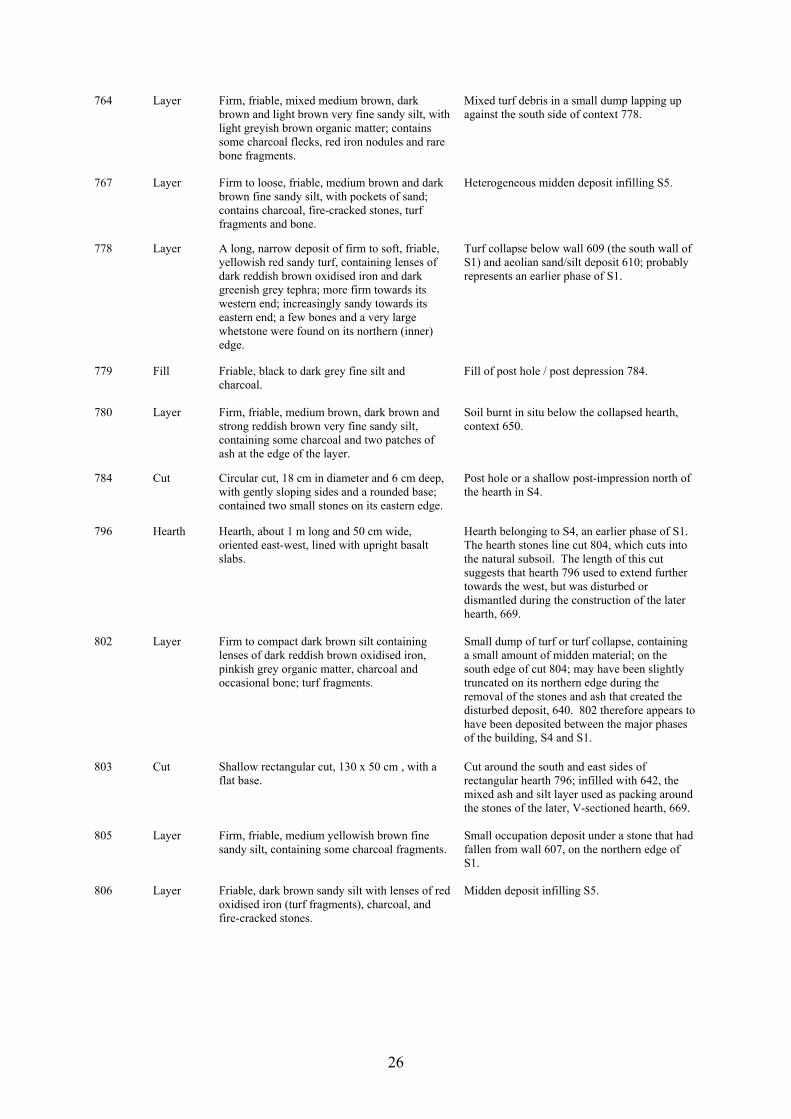
notable internal feature is the hearth
(context 796), which was situated
directly below the hearth belonging
to Structure 1, and was partially
reused in the later construction (see
description of hearth 669, Phase V,
above). Hearth 796 was rectangular
in shape and square in section, was
Figure 4. Earlier Hearth, context 796. oriented east-west, and was lined on
its north, east and south sides with flat, upright basalt slabs (see Fig. 3). These slabs had been
placed within a cut which, at least on its north side, was through natural subsoil (cut 804; only
partially exposed). On the north side of this cut, just west of the hearth, the greenish grey
tephra attributed to ~950 AD, and the black and grey tephras of the Landnám sequence could
be seen. The silts within this natural sequence, which are normally yellowish brown, had
been reddened by exposure to high temperatures in oxidising conditions. The cut, 804,
extends 2.2 m further west than the hearth itself, which is only about 1 x 0.5 m in size. The
fill of this cut appeared to be disturbed hearth debris, consisting of very mixed yellowish
brown silt, orangey and light pinkish brown peat ash, charcoal, and numerous stones (context
640). The base of the cut contains a series of depressions that have probably been created by
the removal of subrounded stones. It would appear, therefore, that hearth 796 had once
extended further to the west, but that it had later been deconstructed. Considering that the
stones of the later hearth, 669, were packed in with very similar hearth debris, it seems likely
that the disturbance of the earlier hearth occurred when the later one was being installed.
20
Few other occupation deposits within Structure 4 were exposed during the excavation
in 2001. The hearth was filled with white ash (probably wood ash) and small calcined bone
fragments (context 797). A post hole that was 18 cm in diameter and 6 cm deep, with two
stones on its eastern edge and a dark grey silty fill, was found just north of the hearth. Along
the inner edge of the north long wall was a multi-laminated, pinkish-brown organic layer,
which may be decomposed hay (context 569), but this was left unexcavated. A black,
charcoal-rich floor deposit, which is expected to be the main occupation surface within
Structure 4, was only partially exposed (context 561). Although most of Structure 4 remains
to be excavated, it is clear that it was a domestic building.
Structure 5, which is north of Structure 4, had not been visible on the ground surface.
It was discovered during the 2000 field season, when the removal of midden deposits north of
Structure 1 exposed the southern part of a barrel pit (606), which had an inner lining of dark
grey fluvial sand (589), and contained a ring-shaped white organic residue at the bottom
(602). Most of the 2001 field season was devoted to the excavation of the complex midden
deposits north of the barrel pit, but at the end of the field season, it was possible to distinguish
the western and southern edges of a cut for Structure 5. So far, this cut does not appear to
have been very deep, but it had vertical sides and it truncated at least the greenish grey tephra
layer (~950 AD), and the silts above it. It may therefore represent the removal of the upper
turf horizon (i.e. the ground surface) from the floor of the structure when it was being built.
The cut begins in the middle of the western side of the barrel pit, and extends west and then
northwards, so that the southern half of the barrel pit’s circumference still contains both the
greenish grey tephra and the Landnám sequence below it. The black, charcoal-rich deposit
exposed at the end of the 2001 field season (context 854) infills the shallow cut, and a short
tongue that extends through the western edge of the cut may indicate an entrance to the
structure. However, since context 854 has yet to be fully exposed, it is not yet possible to
determine whether it represents a black floor layer or another midden deposit dumped inside
the building after it had gone out of use. Further excavation in this area is needed to clarify
the nature of the floor deposits and the full size of the building. The actual construction of the
building also remains to be clarified, since there are no remains of stone or turf walls
anywhere around the barrel pit. The barrel pit makes it clear that the structure functioned as a
storage building or pantry.
Phase I: Pre-structural anthropogenic deposits. The cuts for Structures 4 and 5 truncated a
layer which, by the end of the excavation in 2001, had been widely exposed in the north-
21
western part of Area S (context 658). This layer, which was situated immediately above the
greenish grey tephra attributed to ~950 AD, was about 2 cm thick, and was composed of
laminated, pinkish brown organic layers and medium brown very fine sandy silt. It also
contained occasional flecks of charcoal. The high organic content and laminated structure of
this deposit suggests that it represents the uppermost grass or sod layer on the surface of the
site, which had been rapidly sealed by the anthropogenic deposits. The charcoal flecks and
occasional signs of disturbance in this layer indicate the human presence at the site prior to
the construction of the buildings in Area S.
Conclusion
The 2001 field season confirmed that the main domestic building in Area S, Structure 1, did
have an earlier domestic occupation phase, and that the late 10th- to 11th -century phase of the
building was slightly larger than the later one. The excavation also confirmed the presence of
a small storage building associated with the barrel pit discovered in 2000, and it revealed that
Structure 3 contained a significant stone paving and is therefore likely to have been a cattle
byre. The reduction in the size and number of buildings between the 10th/11th-century phase
and the 12th-century phase, would suggest that the size of the household, and possibly the
economic status of the farm, had been somewhat diminished. There may, of course, be other
contemporary buildings elsewhere at Sveigakot, and this issue can only be resolved with the
further investigation and dating of all of the buildings discovered in Areas P, N and T.
This year’s field season also revealed that the occupation sequence in Area S had not
been continuous, but that there had been a complete break at some point – probably during the
11th century – during which there was time for Structure 4 to partially collapse, and for
aeolian silt and sand to accumulate inside and outside of its southern wall. The excavation
also showed that there had been sporadic activity in the main domestic structure between the
major occupation phases represented by Structures 1 and 4. This activity, which took the
form of small, temporary hearths and the dumping of small ashy and organic layers in the
northern and eastern parts of the building, may indicate the site had been occasionally used as
a temporary shelter or a shieling after the partial collapse of Structure 4. The changing status
of Sveigakot from a permanently occupied farm to an abandoned settlement, and from a
temporarily occupied shieling to a smaller, but permanent farm again, has implications for the
changing environment, economics, and/or politics of the region.
22
Further work at the site is needed in order to confirm whether or not Structure 3 was
indeed a byre, and to clarify the physical relationships between Structures 3, 4 and 5. The
precise size and construction of Structures 4 and 5 has yet to be determined as well. In the
meantime, laboratory work continues on the internal occupation deposits of Structure 1 in
order to extract as much information as possible about the organisation and use of space
inside the building. It is also hoped that micromorphological and sedimentary analyses of the
black deposit in putative Structure 2 will help to confirm or negate the hypothesis that it was a
floor layer, and in the event that it was a floor, that these analyses will provide more
information about the function of the building.
Acknowledgements
Many thanks to the excellent team who worked on the excavation of Area S in 2001: Elín Ósk
Hreiðarsdóttir, Anne-Mette Mortensen, Jeppe Skovby, Katarzyna Skrzynska, Orri
Vésteinsson and Robert Zukowski. I am very grateful for the dedication and good spirits of
everyone on the crew.
23
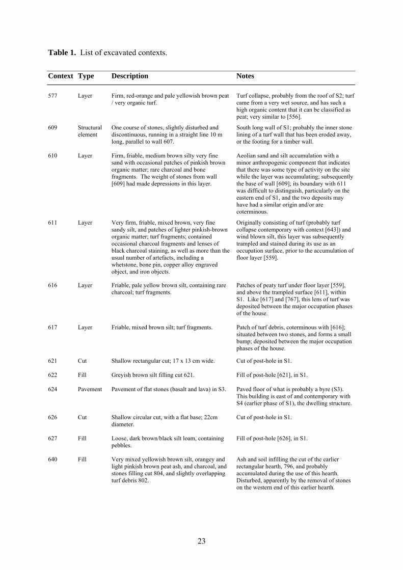
Table 1. List of excavated contexts.
Context Type Description Notes
577 Layer Firm, red-orange and pale yellowish brown peat
/ very organic turf. Turf collapse, probably from the roof of S2; turf
came from a very wet source, and has such a high organic content that it can be classified as peat; very similar to [556].
609 Structural element
One course of stones, slightly disturbed and discontinuous, running in a straight line 10 m long, parallel to wall 607.
South long wall of S1; probably the inner stone lining of a turf wall that has been eroded away, or the footing for a timber wall.
610 Layer Firm, friable, medium brown silty very fine sand with occasional patches of pinkish brown organic matter; rare charcoal and bone fragments. The weight of stones from wall [609] had made depressions in this layer.
Aeolian sand and silt accumulation with a minor anthropogenic component that indicates that there was some type of activity on the site while the layer was accumulating; subsequently the base of wall [609]; its boundary with 611 was difficult to distinguish, particularly on the eastern end of S1, and the two deposits may have had a similar origin and/or are coterminous.
611 Layer Very firm, friable, mixed brown, very fine sandy silt, and patches of lighter pinkish-brown organic matter; turf fragments; contained occasional charcoal fragments and lenses of black charcoal staining, as well as more than the usual number of artefacts, including a whetstone, bone pin, copper alloy engraved object, and iron objects.
Originally consisting of turf (probably turf collapse contemporary with context [643]) and wind blown silt, this layer was subsequently trampled and stained during its use as an occupation surface, prior to the accumulation of floor layer [559].
616 Layer Friable, pale yellow brown silt, containing rare charcoal; turf fragments.
Patches of peaty turf under floor layer [559], and above the trampled surface [611], within S1. Like [617] and [767], this lens of turf was deposited between the major occupation phases of the house.
617 Layer Friable, mixed brown silt; turf fragments. Patch of turf debris, coterminous with [616]; situated between two stones, and forms a small bump; deposited between the major occupation phases of the house.
621 Cut Shallow rectangular cut; 17 x 13 cm wide. Cut of post-hole in S1.
622 Fill Greyish brown silt filling cut 621. Fill of post-hole [621], in S1.
624 Pavement Pavement of flat stones (basalt and lava) in S3. Paved floor of what is probably a byre (S3). This building is east of and contemporary with S4 (earlier phase of S1), the dwelling structure.
626 Cut Shallow circular cut, with a flat base; 22cm diameter.
Cut of post-hole in S1.
627 Fill Loose, dark brown/black silt loam, containing pebbles.
Fill of post-hole [626], in S1.
640 Fill Very mixed yellowish brown silt, orangey and light pinkish brown peat ash, and charcoal, and stones filling cut 804, and slightly overlapping turf debris 802.
Ash and soil infilling the cut of the earlier rectangular hearth, 796, and probably accumulated during the use of this hearth. Disturbed, apparently by the removal of stones on the western end of this earlier hearth.
24
642 Fill Very mixed yellowish brown silt, grey and pinkish peat ash, and charcoal, filling cut 803, and packed around the stones of hearth 669. Contained small calcined bone fragments, and half a bead.
Mixed ash and soil packing around the stones used to construct the later V-shaped hearth 669. This material is itself clearly derived from hearth debris, and was probably removed from 640 (which had accumulated around earlier hearth 796) during the construction of the later hearth.
646 Layer Loose, friable, dark grey and black fine silt and ash layers, with occasional charcoal fragments and rare small calcined bone fragments.
Does not feel compact, but is nevertheless probably the floor surface of S2.
650 Layer Pile of stones embedded in a loose, friable, light greyish-brown silt and ash deposit containing occasional charcoal and charcoal staining.
Probably a small, temporarily used hearth. The soil below (context 780) showed the discoloration (oxidation) typical of in situ burning.
653 Layer Thin lens of firm, compacted light brown silt, and yellowish brown and pinkish brown organic matter, just north of floor 559, between post pads 656 b+c.
Probably a deposit of hay or straw that accumulated north of the main area of traffic/trampling in the centre of the building (represented by floor 559), possibly underneath a bench.
656 Post pads Four flat basalt post-pads, located in a square in the exact centre of S1. All are radially cracked.
Pads for roof-supporting posts, around which floor 559 accumulated.
659 Layer Thin spread of mixed medium brown very fine sandy silt, light greyish brown organic matter, red oxidised iron, and occasional charcoal flecks. Contains some bones and charcoal.
Thin spread of organic midden material on the north edge of the excavation area, north of S1. Closely resembles context 678.
669 Hearth Rectangular hearth with a V-shaped section, constructed of flat basalt stones, supported on the outside by rounded, fist-sized cobbles, packed in with a mixture of ash and soil (context 642). Three flat stones were placed horizontally just outside of the hearth, on its north, south and east sides.
Central hearth of Structure 1. The three flat stones form a triangle that could have supported a cooking tripod.
677 Layer Firm to soft, friable, homogenous dark brown fine sandy silt.
Aeolian silt / soil accumulation above turf collapse over building S3.
678 Layer Mixed dark brown fine sandy silt, yellowish and greyish brown organic matter, and charcoal.
Thin spread of organic midden material on the north edge of the excavation area, north of S3. Closely resembles context 659.
679 Layer Very firm, friable, dark brown silt, with abundant lenses of red oxidised iron and grey tephra; turf fragments.
Turf collapse from the walls and/or roof of S3, surrounding and partially covering pavement 624, especially on its NE edge.
682 Layer Firm, plastic very light greyish brown and pinkish brown organic matter, mottled with lenses of reddish brown oxidised iron.
Peaty turf over the pavement 624 and probably representing the roof collapse of S3. The high organic content of this layer is very unusual, and closely resembles context 556, which was interpreted as the peaty turf roofing material of S1.
683 Layer Firm to soft, friable, dark brown with a few light brown mottles of very fine sandy silt
Soil and aeolian silt accumulation above turf collapse over building S3.
685 Layer Firm, friable, fairly homogenous, medium brown very fine sandy silt, containing a few patches of turf (containing oxidised iron), and occasional charcoal fragments, and small pieces of badly decayed wood.
Mainly soil and aeolian silt accumulation around and above the collapsing building S1.
25
690 Layer Firm, friable, very mixed deposit of medium brown very fine sandy silt, containing abundant flecks of yellowish brown organic matter and reddish brown oxidised iron. Contained some bone and charcoal.
Small dump of mixed midden material and turf, possibly to level a small hollow between two stones just east of the barrel pit, in S5.
692 Layer Very firm, friable strong brown silt containing 40-50% organic matter in the form of sticky, pinkish brown lenses.
Layer of dumped plant matter (possibly hay) and/or other organic matter within the midden deposit infilling the barrel pit and S5.
695 Layer Firm, friable, mottled dark brown and yellowish brown very fine sandy silt; turf fragments.
Layer of dumped turf debris within the midden deposit infilling the barrel pit and S5.
708 Layer Firm to soft, friable medium brown fine sandy silt, containing occasional charcoal, bone and 1/2 a sandstone spindle whorl.
Mainly soil and aeolian silt accumulation, containing some reworked midden material, above the midden infilling the barrel pit and S5.
710 Layer Loose, friable, dark brown sandy silt with grey tephra (possibly ~950 AD) and flecks of black tephras from the LNL sequence.
Turf collapse, aligned north-south on the western edge of the low rise on which the ruin is situated; possibly the turf collapse of western wall of S2.
724 Layer Friable, firm, dark brown fine sandy silt containing lenses of reddish oxidised iron and dark grey tephra; turf fragments.
Turf collapse south of S1. Probably the continuation of context 554, which was excavated in 2000.
728 Layer Firm to loose, friable, reddish brown and dark brown very fine sandy silt, mottled with dark grey tephra; turf fragments.
Turf collapse east of S1. The continuation of context 590, which was excavated in 2000. This layer may represent the collapse of the eastern wall of S1.
733 Layer Small layer of very firm, yellowish brown turf fragments.
Layer of turf collapse within a very mixed deposit of turf, soil, aeolian silt, and wood fragments south of S1.
739 Layer Friable, light brown fine silt and abundant organic matter, with rare charcoal fragments.
Small deposit of turf abutting the north side of the north wall of S1 (context 607).
740 Layer Friable, dark brown sandy silt containing turf fragments and occasional charcoal and ash.
A discreet midden dump abutting the north side of the north wall of S1 (context 607).
741 Layer Friable, brown silt; turf fragments. Small deposit of turf abutting the north side of the north wall of S1 (context 607).
742 Fill Homogenous yellowish brown silt. Fill of cut 745.
745 Cut Sub-circular cut, c.40 cm in diameter and 8cm deep, with a flat base sloping gently to the east.
Cut through context 658 and filled with context 742. Small pit of unknown function on the south side of S2.
746 Layer Friable to loose dark brown and brown sandy silt.
Aeolian silt / soil accumulation above the midden deposits infilling the barrel pit and S5. Very similar to 708. The continuation of 551 (excavated in 2000).
760 Layer Loose dark grey sand (fine to medium-sized) containing occasional fragments of yellow and brown turf.
Aeolian sand accumulation in a cavity created by sharply vertical stones in a midden deposit creating a sand trap. Mixed into the bottom 5-10 cm of the layer were some bone and charcoal fragments.
763 Layer Friable brown sandy silt, containing turf debris, small pebbles, ash and charcoal.
Mixed turf debris and midden material inside of S1, north of and slightly overlapped by floor 559.
26
764 Layer Firm, friable, mixed medium brown, dark brown and light brown very fine sandy silt, with light greyish brown organic matter; contains some charcoal flecks, red iron nodules and rare bone fragments.
Mixed turf debris in a small dump lapping up against the south side of context 778.
767 Layer Firm to loose, friable, medium brown and dark brown fine sandy silt, with pockets of sand; contains charcoal, fire-cracked stones, turf fragments and bone.
Heterogeneous midden deposit infilling S5.
778 Layer A long, narrow deposit of firm to soft, friable, yellowish red sandy turf, containing lenses of dark reddish brown oxidised iron and dark greenish grey tephra; more firm towards its western end; increasingly sandy towards its eastern end; a few bones and a very large whetstone were found on its northern (inner) edge.
Turf collapse below wall 609 (the south wall of S1) and aeolian sand/silt deposit 610; probably represents an earlier phase of S1.
779 Fill Friable, black to dark grey fine silt and charcoal.
Fill of post hole / post depression 784.
780 Layer Firm, friable, medium brown, dark brown and strong reddish brown very fine sandy silt, containing some charcoal and two patches of ash at the edge of the layer.
Soil burnt in situ below the collapsed hearth, context 650.
784 Cut Circular cut, 18 cm in diameter and 6 cm deep, with gently sloping sides and a rounded base; contained two small stones on its eastern edge.
Post hole or a shallow post-impression north of the hearth in S4.
796 Hearth Hearth, about 1 m long and 50 cm wide, oriented east-west, lined with upright basalt slabs.
Hearth belonging to S4, an earlier phase of S1. The hearth stones line cut 804, which cuts into the natural subsoil. The length of this cut suggests that hearth 796 used to extend further towards the west, but was disturbed or dismantled during the construction of the later hearth, 669.
802 Layer Firm to compact dark brown silt containing lenses of dark reddish brown oxidised iron, pinkish grey organic matter, charcoal and occasional bone; turf fragments.
Small dump of turf or turf collapse, containing a small amount of midden material; on the south edge of cut 804; may have been slightly truncated on its northern edge during the removal of the stones and ash that created the disturbed deposit, 640. 802 therefore appears to have been deposited between the major phases of the building, S4 and S1.
803 Cut Shallow rectangular cut, 130 x 50 cm , with a flat base.
Cut around the south and east sides of rectangular hearth 796; infilled with 642, the mixed ash and silt layer used as packing around the stones of the later, V-sectioned hearth, 669.
805 Layer Firm, friable, medium yellowish brown fine sandy silt, containing some charcoal fragments.
Small occupation deposit under a stone that had fallen from wall 607, on the northern edge of S1.
806 Layer Friable, dark brown sandy silt with lenses of red oxidised iron (turf fragments), charcoal, and fire-cracked stones.
Midden deposit infilling S5.
27
807 Layer Two stones embedded in a small deposit of firm, friable, dark brown fine sandy silt.
Stones are in line with three others placed between post pads 656 b and c, on the north edge of floor 559 (S1), and are slightly overlapped by that layer. These stones may delineate a bench or some other type of substantial piece of furniture, since there were no trampled deposits north of this line of stones.
808 Layer Friable, mixed very dark greyish black silt, containing lumps of dark brown and reddish brown silt and small flecks of charcoal.
Small, thin charcoal-rich lens below floor 559, in S1.
809 Layer Soft, plastic, dark reddish brown organic silt, with charcoal flecks.
Thin lens of organic matter (possibly decomposed hay) between major occupation phases S1 and S4.
810 Layer Firm, friable, dark brown very fine silty sand containing bone, charcoal, and an iron nail.
Small occupation deposit that accumulated north of post pad 565b, and was slightly overlapped by the organic/hay lens 653. Both 810 and 653 were north of floor 559, and probably contemporary with it, although they formed outside of the main area of occupation/trampling within S1.
811 Layer Friable, light greyish brown sandy silt containing light brown and light grey ash and abundant pieces of charcoal.
Lens of mixed silt, ash and charcoal between major occupation phases S1 and S4.
812 Layer Friable, dark brown sandy silt with reddish brown and yellowish brown lenses; contains some bone and charcoal.
Turf dump / midden deposit infilling S5.
814 Layer Firm, reddish brown organic-rich silt; 'bog turf' rich in oxidised iron; contains some bone and a few artefacts (whetstone and an iron nail).
Either a turf dump infilling S5, or turf collapse from the north/east wall of S5.
815 Layer Firm to loose, friable, dark brown, homogenous fine sand.
Small, thin lens of sand below major occupation phase S1.
816 Layer Firm, friable, mottled very dark greyish black sandy silt, and very light grey/white organic silt; contains small charcoal flecks.
Small, thin lens of charcoal-stained silt and white (possibly organic) residues; deposited between major occupation phases S1 and S4.
817 Layer Firm, friable, mixed medium brown and strong brown very fine sandy silt, lenses of yellowish brown and pinkish brown organic matter, and lenses of greenish-grey tephra; turf fragments; slightly sandier on its eastern end; contains some small flecks of charcoal.
Sandy, mixed turf collapse on the eastern end of context 778, and apparently coterminous with that layer; below wall 609 and the aeolian silt/sand deposit 610, contexts 778 and 817 may represent the collapsed walls of an earlier phase of S1.
818 Layer Soft, dark brown silty sand; homogenous and without inclusions.
Small, thin lens of aeolian silt accumulated below floor 559; deposited between major occupation phases S1 and S4.
819 Layer Firm, dark grey and greyish brown sandy silt, containing charcoal and a whetstone.
Silt layer below 814; could either represent a silt lens within a midden deposit, or a floor within S5. Will be investigated further in 2002.
820 Layer Firm, friable, brown sandy silt containing fire cracked stones, bones, and charcoal.
Midden deposit infilling S5.
821 Layer Soft, mixed very dark brown and black sandy silt, ash, and pieces of charcoal.
Ash and charcoal layer between major occupation phases S1 and S4.
28
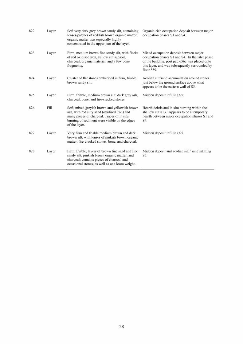
822 Layer Soft very dark grey brown sandy silt, containing lenses/patches of reddish brown organic matter; organic matter was especially highly concentrated in the upper part of the layer.
Organic-rich occupation deposit between major occupation phases S1 and S4.
823 Layer Firm, medium brown fine sandy silt, with flecks of red oxidised iron, yellow silt subsoil, charcoal, organic material, and a few bone fragments.
Mixed occupation deposit between major occupation phases S1 and S4. In the later phase of the building, post pad 656c was placed onto this layer, and was subsequently surrounded by floor 559.
824 Layer Cluster of flat stones embedded in firm, friable, brown sandy silt.
Aeolian silt/sand accumulation around stones, just below the ground surface above what appears to be the eastern wall of S5.
825 Layer Firm, friable, medium brown silt, dark grey ash, charcoal, bone, and fire-cracked stones.
Midden deposit infilling S5.
826 Fill Soft, mixed greyish brown and yellowish brown ash, with red silty sand (oxidised iron) and many pieces of charcoal. Traces of in situ burning of sediment were visible on the edges of the layer.
Hearth debris and in situ burning within the shallow cut 813. Appears to be a temporary hearth between major occupation phases S1 and S4.
827 Layer Very firm and friable medium brown and dark brown silt, with lenses of pinkish brown organic matter, fire-cracked stones, bone, and charcoal.
Midden deposit infilling S5.
828 Layer Firm, friable, layers of brown fine sand and fine sandy silt, pinkish brown organic matter, and charcoal; contains pieces of charcoal and occasional stones, as well as one loom weight.
Midden deposit and aeolian silt / sand infilling S5.
29
Przemysław Urbańczyk:
Sveigakot 2001. Area T – pit house
Introduction
In 2001 area T was given to the Polish team invited to take part in the Landscapes of
Settlement project. The members were: Katarzyna Skrzyńska and Robert Żukowski (both
MA) under the lead of Przemysław Urbańczyk – all representing the Institute of Archaeology
and Ethnology of the Polish Academy of Sciences in Warsaw.
It was the second excavation season of area T as an extensive midden deposit had been
discovered there and largely excavated in 2000 by a team of zooarchaeologists under the
leadership of Tom McGovern. In an effort to define the southern and western limits of the
sheet midden (M) – which covers much of the southern part of the site – a square test-pit had
been placed at 893/303 meters of the coordination grid. Excavation quickly indicated that the
undersurface layering was different from what should be expected at a midden site. In order to
get a wider perspective for stratigraphic observations a regular 5x5 m trench was laid out.
Deturfing and subsequent clearing of the subsoil layers showed a distinct depression in the
centre of the trench. Further shallow test pitting of the adjacent area indicated the presence of
a sunken structure that had been levelled with a series of filling layers. This structure clearly
stretched behind the northern and southern edges of that trench. At this stage exploration of
the trench was halted and the area was given a separate code “T”. In 2000 a very rich midden
layer was excavated in area T and cleared off the earlier deposits which now awaited the
attention of the Polish team.
Recording, sampling and excavation routines
The aim of this excavation was to achieve a clear stratigraphic sequence with all identified
contexts/units recorded so that post-excavation reconstruction of the stratification process
would be possible. Special emphasis was laid on regular sampling of layers that might yield
environmental data.
Thus, a typical set of routines, commonly used at multi-strata sites, was applied.
According to the standard procedures each layer/context was treated separately. Every time
30
attention of the excavators concentrated on the youngest of all the visible contexts. The first
step was to draw a plan of the freshly exposed surface of a unit in its full extent. In result, a
series of single-layer plans was produced. Every one records the visible extent and
characteristic elements of the upper face of a context that was also levelled and photographed.
All contexts were sampled following the advice by T. McGovern and K. Milek.
Recording and sampling was followed by excavation. Each layer was removed by
trowelling out square (1x1 m) after square. All the removed soil was sieved and number of
buckets counted.3 Finds retrieved from the sieve (mostly mammal and fish bones) were
localised by coordinates of a particular grid square, while artefacts found in situ were given
precise three-dimensional coordinates.
After the surface was scraped clean again, a new context was identified and the same
sequence of routines followed: photo, drawing and description, levelling, sampling,
excavating. The pace of daily work depended on the extent and volume of identified layers,
complexity of its outlook, texture of soil and weather conditions. Results of every day
activities were described in a diary illustrated by colour photographs taken with a digital
camera “SONY Cybershot”.
Strategy
In a non-rescue situation there is no need to attempt pre-designing a “complete” and rigid
strategy of excavation because it is usually difficult (if not impossible) to accommodate all
unforeseen circumstances. The strategy has to be adjusted in face of the surprises that often
await the archaeologist trying to have a look under the turf.
The most common problem is a feeling that the trench so cleverly designed at the
beginning always appears too small. Apart from very small sites that may be excavated as a
discreete whole, there are always some layers or features that extend outside the limits of the
excavation. However, the temptation to enlarge our trench every time something happened at
its edge would have resulted in the excavated area growing infinitely. Therefore, one has to
compromise between the will to answer “all” questions and the necessity to end excavation in
a reasonable time. It is up to the intuition of the supervisor to decide which questions are “the
most important” ones. And such a decision may always be the subject of post-excavational
questioning.
3 Unfortunately the counting routine sometimes failed due to the human factor.
31
Another strategic decision that has to be made is: How detailed should the excavation,
recording and sampling be? There is hardly any limit to the precision of archaeological
observation which can possibly be attained while in the field. However, the obvious price to
be paid for increasing the accuracy is a deceleration of the progress of our work. A balance
between the two should be decided upon in advance of excavation but, again, it is the
structure of subsurface stratification that may be decisive in finding the final solution.
Usually, there is no time in the field to apply complex analysis of all circumstances and the
supervisor has to rely on his/her own experience and intuition. And there is no objective way
to evaluate such a decision making process.
The third important level of strategic decisions to be taken refers to the
professionalism of work while in the field. Usually it is difficult to engage highly experienced
staff only. Leaving aside the problem of how to measure field experience, it is advisable to
have a team consisting of archaeologists of different backgrounds. This is because of the
necessity to make the decision-making process more objective. However, the duty to train
new cadres should not be forgotten. Anyway, the ideal situation is when people of different
experience and abilities work together. Once more, it is up to the supervisor to decide the
price to be paid for the training of adepts of field archaeology. And his/her subjective
judgement will have a substantial impact on the quality of the work carried out.
The final of these considerations of the excavation strategy takes into account the
problem of the decision making itself. Excavation is a process of permanent deciding. It
consists of an infinite chain of taking decisions of varying importance. Some of them may
have a strategic value while others are hardly noticeable. Some are easy while others need
serious consideration of a number of pros and contras. Some decisions are reversible while
others may have serious consequences. There are no universal rules of decision making for an
excavation supervisor and they often have to face post excavation criticism. However, in the
field decisions must be taken even if they may appear risky because avoiding decisions
introduces chaos and may obscure stratigraphic information.
The above-mentioned observations imply that archaeological excavation is a very
complex process that involves serious procedures of a strategic importance. The most
important aspect of this process is that its consequences may cause irreversible loss of
valuable data because archaeological evidence is always unique and it undergoes total
destruction in result of our research activity. This basic fact puts a heavy burden upon our
shoulders because there is no way to avoid some mistakes. This should make us alert in order
32
to minimise eventual loss. Unfortunately there is no universal instruction how to do it
effectively in real time and every supervisor has to bear this responsibility in their mind.
Stratigraphic data
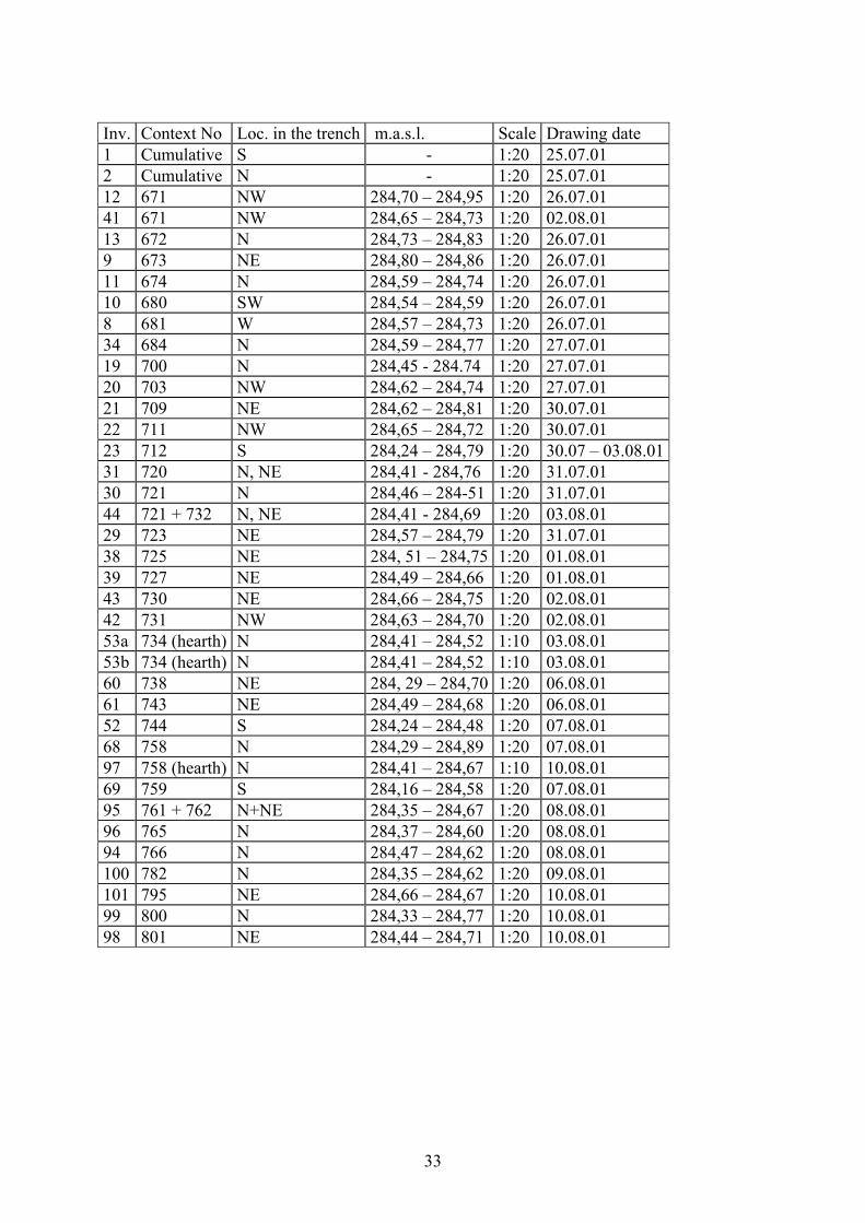
During the three weeks of the 2001 excavation 35 horizontal contexts and a number of post-
holes were identified and recorded on plans listed below4.
Excavation started within the limits of the trench begun in the previous summer. It was
a 5 x 5 m. square (SE coordinates 892/302) designed after the above-mentioned first test-pit
revealed a structural stratigraphy underlying the midden.
After all the plastic sheets and soil covering the trench had been removed the surface
exposed in 2000 was uncovered. Along the eastern edge of the trench there was flattish
surface of natural gravel. In the centre, where the upper sandy layers had been removed, there
was a depression with several filling layers visible.
The depression visible in the centre apparently continued beyond the N and S profiles.
Therefore, before stratigraphic excavation started, the trench was enlarged in both directions
(3 metres towards N and two metres towards S) and these extensions were deturfed and
scraped clean. The exposed situation is recorded on the general multi-context plan (Fig. 1).5
4 Katarzyna Skrzyńska prepared the register. 5 Digitised plans that illustrate this text were prepared by Robert Żukowski who used field documentation drawn by himself and Katarzyna Skrzyńska.
33
Inv. Context No Loc. in the trench m.a.s.l. Scale Drawing date 1 Cumulative S - 1:20 25.07.01 2 Cumulative N - 1:20 25.07.01 12 671 NW 284,70 – 284,95 1:20 26.07.01 41 671 NW 284,65 – 284,73 1:20 02.08.01 13 672 N 284,73 – 284,83 1:20 26.07.01 9 673 NE 284,80 – 284,86 1:20 26.07.01 11 674 N 284,59 – 284,74 1:20 26.07.01 10 680 SW 284,54 – 284,59 1:20 26.07.01 8 681 W 284,57 – 284,73 1:20 26.07.01 34 684 N 284,59 – 284,77 1:20 27.07.01 19 700 N 284,45 - 284.74 1:20 27.07.01 20 703 NW 284,62 – 284,74 1:20 27.07.01 21 709 NE 284,62 – 284,81 1:20 30.07.01 22 711 NW 284,65 – 284,72 1:20 30.07.01 23 712 S 284,24 – 284,79 1:20 30.07 – 03.08.01 31 720 N, NE 284,41 - 284,76 1:20 31.07.01 30 721 N 284,46 – 284-51 1:20 31.07.01 44 721 + 732 N, NE 284,41 - 284,69 1:20 03.08.01 29 723 NE 284,57 – 284,79 1:20 31.07.01 38 725 NE 284, 51 – 284,75 1:20 01.08.01 39 727 NE 284,49 – 284,66 1:20 01.08.01 43 730 NE 284,66 – 284,75 1:20 02.08.01 42 731 NW 284,63 – 284,70 1:20 02.08.01 53a 734 (hearth) N 284,41 – 284,52 1:10 03.08.01 53b 734 (hearth) N 284,41 – 284,52 1:10 03.08.01 60 738 NE 284, 29 – 284,70 1:20 06.08.01 61 743 NE 284,49 – 284,68 1:20 06.08.01 52 744 S 284,24 – 284,48 1:20 07.08.01 68 758 N 284,29 – 284,89 1:20 07.08.01 97 758 (hearth) N 284,41 – 284,67 1:10 10.08.01 69 759 S 284,16 – 284,58 1:20 07.08.01 95 761 + 762 N+NE 284,35 – 284,67 1:20 08.08.01 96 765 N 284,37 – 284,60 1:20 08.08.01 94 766 N 284,47 – 284,62 1:20 08.08.01 100 782 N 284,35 – 284,62 1:20 09.08.01 101 795 NE 284,66 – 284,67 1:20 10.08.01 99 800 N 284,33 – 284,77 1:20 10.08.01 98 801 NE 284,44 – 284,71 1:20 10.08.01
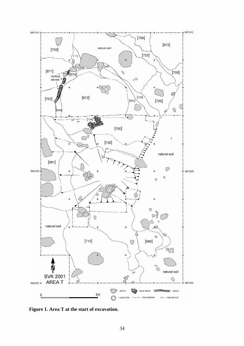
34
Figure 1. Area T at the start of excavation.
35
It was obvious that the northern extension had to be excavated first in order to achieve
stratigraphic synchrony all over the trench. This was accomplished when the context 700 was
exposed (see Fig. 7). However, further excavation still concentrated in the northern half of the
trench where a sequence of layers filling a large sub-rectangular depression had to be
removed. After three weeks we still did not manage to empty this basin of stratification where
an “independent” stratigraphic sequence had accumulated. Two other relatively separate
basins of accumulation were recorded in the NW and NE corners of the trench.
The stratigraphic matrix (Fig. 2) cumulates basic information on the relative
chronology. The main axis of this scheme refers to the sequence of contexts identified within
the sunken hut depression where interchangeable floor accumulations and levelling layers
were recorded.
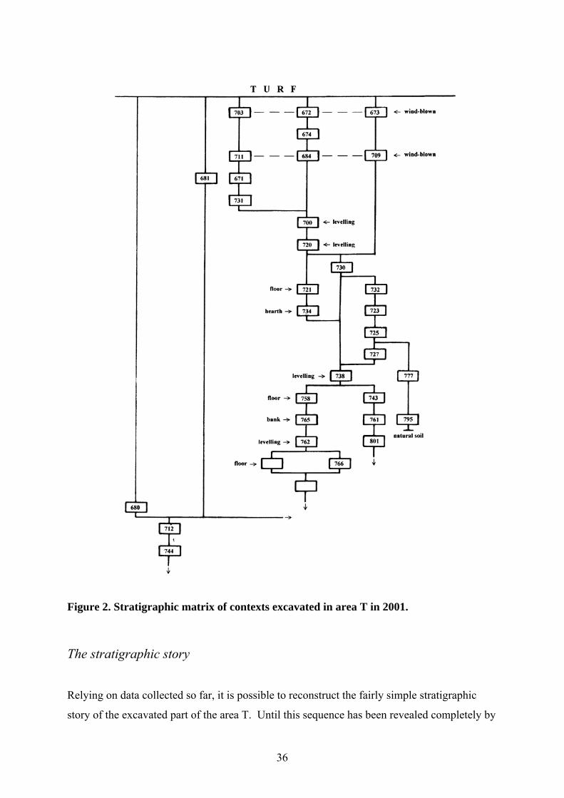
36
782
Figure 2. Stratigraphic matrix of contexts excavated in area T in 2001.
The stratigraphic story
Relying on data collected so far, it is possible to reconstruct the fairly simple stratigraphic
story of the excavated part of the area T. Until this sequence has been revealed completely by
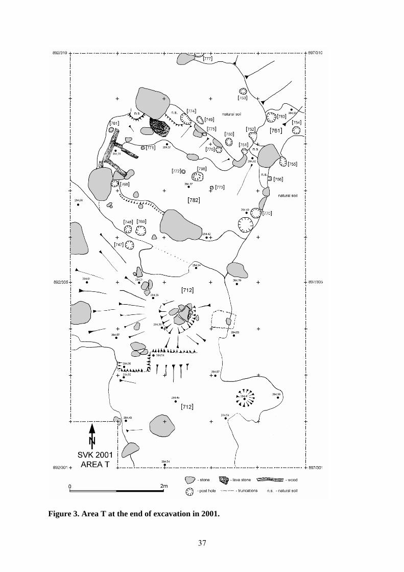
37
Figure 3. Area T at the end of excavation in 2001.
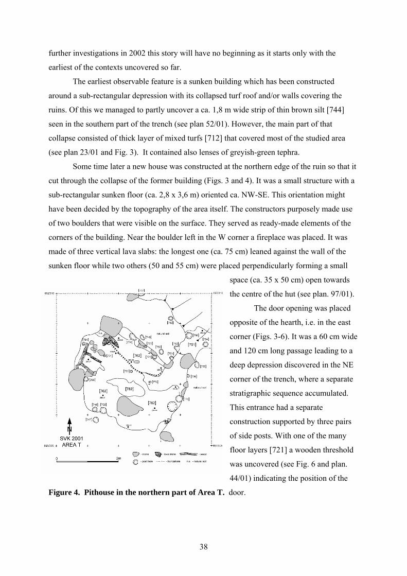
38
further investigations in 2002 this story will have no beginning as it starts only with the
earliest of the contexts uncovered so far.
The earliest observable feature is a sunken building which has been constructed
around a sub-rectangular depression with its collapsed turf roof and/or walls covering the
ruins. Of this we managed to partly uncover a ca. 1,8 m wide strip of thin brown silt [744]
seen in the southern part of the trench (see plan 52/01). However, the main part of that
collapse consisted of thick layer of mixed turfs [712] that covered most of the studied area
(see plan 23/01 and Fig. 3). It contained also lenses of greyish-green tephra.
Some time later a new house was constructed at the northern edge of the ruin so that it
cut through the collapse of the former building (Figs. 3 and 4). It was a small structure with a
sub-rectangular sunken floor (ca. 2,8 x 3,6 m) oriented ca. NW-SE. This orientation might
have been decided by the topography of the area itself. The constructors purposely made use
of two boulders that were visible on the surface. They served as ready-made elements of the
corners of the building. Near the boulder left in the W corner a fireplace was placed. It was
made of three vertical lava slabs: the longest one (ca. 75 cm) leaned against the wall of the
sunken floor while two others (50 and 55 cm) were placed perpendicularly forming a small
space (ca. 35 x 50 cm) open towards
the centre of the hut (see plan. 97/01).
The door opening was placed
opposite of the hearth, i.e. in the east
corner (Figs. 3-6). It was a 60 cm wide
and 120 cm long passage leading to a
deep depression discovered in the NE
corner of the trench, where a separate
stratigraphic sequence accumulated.
This entrance had a separate
construction supported by three pairs
of side posts. With one of the many
floor layers [721] a wooden threshold
was uncovered (see Fig. 6 and plan.
44/01) indicating the position of the
Figure 4. Pithouse in the northern part of Area T. door.
39
There is not much evidence to discuss the superstructure of the house as it had
undergone an almost total postdepositonal destruction. The roof was supported by posts
placed at the edges of the sunken floor (see Figs. 3 and 4). The only well preserved part of the
house, i.e. the NE half shows a row of regularly spaced posts [774, 775, 776] that stood 50 cm
one from another. The fourth corner post must have stood on the boulder at the N corner of
the house. Two post-moulds [749, 750] visible on the upper edge of the floor depression may
be evidence of additional reinforcement of the turf wall there. By the opposite heavily
destroyed SW wall only a cluster of three post-holes [747, 748,769] survived. Such a
concentration may indicate some repairing of the ageing house. There must have been a
corner post resting on the natural pedestal of the large boulder visible in the W corner. So far,
only one post-hole [770] was identified by the SE wall. All these posts belonged to different
phases, which will be explained below.
We do not know what the original design of this house was because excavation of the
floor layers is not finished yet. Therefore, the following description of the stratigraphic events
starts sometime after the building was constructed.
The earliest deposit inside the hut excavated so far is a living-floor layer [782] which
covered the centre of the house (see Fig. 3). It consisted of dark silt containing pieces of
charcoal and burnt bones. The surface was black and trampled. Being greyish-brown near the
SE wall it turned black near the fireplace and reaching inside it as an ash-and-charcoal
deposit. There was a 3-5 cm high elevation stretching along the SW wall, which may indicate
the position of a bench for sitting or sleeping, which included the flat surface of a large
boulder protruding through the floor. Full-bag samples were collected from every quarter
square metre.
Next there was a thin gravelly layer [800] which had accumulated along the NE wall
(see plan 99/01). It is visible as an irregular strip spread from the outer wall of the stone
fireplace, stretching along the edge of the floor and reaching the door opening. It may
represent a levelling made to even an earlier floor level.
To the same stratigraphic phase belong three post-holes [774, 775 and 776] forming a
row along the NE wall. Yellow sandy soil [766] removed from these holes was spread along
the edge of the floor (see plan 94/01).
After this repair(?) the interior of the house was rearranged (Fig. 4). The floor was
covered with brownish silt [762] so that the low bank that was earlier visible along the SW
wall was levelled (see plan 95/01). A new “bench” was constructed along the NE wall where
7-10 cm of brownish sand [765] made a low “platform” ca. 80 x 180 cm. It stretched from the
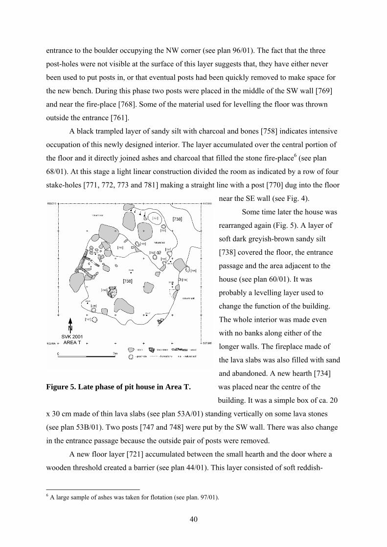
40
entrance to the boulder occupying the NW corner (see plan 96/01). The fact that the three
post-holes were not visible at the surface of this layer suggests that, they have either never
been used to put posts in, or that eventual posts had been quickly removed to make space for
the new bench. During this phase two posts were placed in the middle of the SW wall [769]
and near the fire-place [768]. Some of the material used for levelling the floor was thrown
outside the entrance [761].
A black trampled layer of sandy silt with charcoal and bones [758] indicates intensive
occupation of this newly designed interior. The layer accumulated over the central portion of
the floor and it directly joined ashes and charcoal that filled the stone fire-place6 (see plan
68/01). At this stage a light linear construction divided the room as indicated by a row of four
stake-holes [771, 772, 773 and 781] making a straight line with a post [770] dug into the floor
near the SE wall (see Fig. 4).
Some time later the house was
rearranged again (Fig. 5). A layer of
soft dark greyish-brown sandy silt
[738] covered the floor, the entrance
passage and the area adjacent to the
house (see plan 60/01). It was
probably a levelling layer used to
change the function of the building.
The whole interior was made even
with no banks along either of the
longer walls. The fireplace made of
the lava slabs was also filled with sand
and abandoned. A new hearth [734]
Figure 5. Late phase of pit house in Area T. was placed near the centre of the
building. It was a simple box of ca. 20
x 30 cm made of thin lava slabs (see plan 53A/01) standing vertically on some lava stones
(see plan 53B/01). Two posts [747 and 748] were put by the SW wall. There was also change
in the entrance passage because the outside pair of posts were removed.
A new floor layer [721] accumulated between the small hearth and the door where a
wooden threshold created a barrier (see plan 44/01). This layer consisted of soft reddish-
6 A large sample of ashes was taken for flotation (see plan. 97/01).
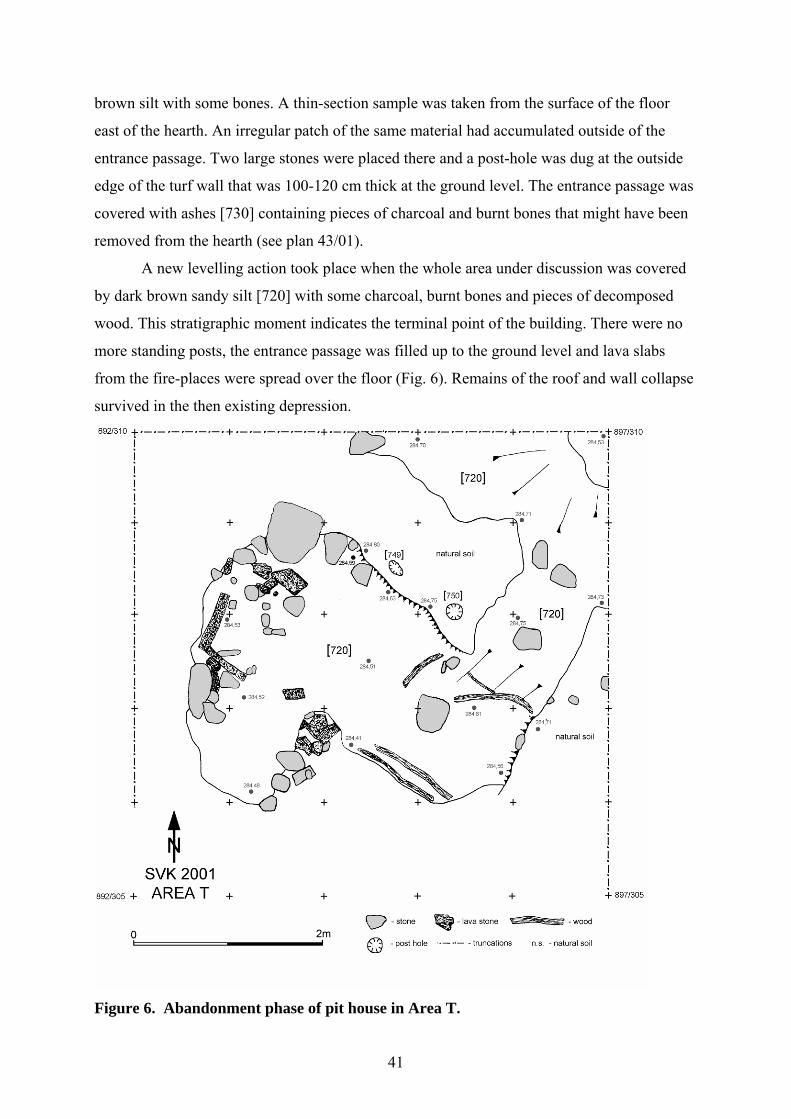
41
brown silt with some bones. A thin-section sample was taken from the surface of the floor
east of the hearth. An irregular patch of the same material had accumulated outside of the
entrance passage. Two large stones were placed there and a post-hole was dug at the outside
edge of the turf wall that was 100-120 cm thick at the ground level. The entrance passage was
covered with ashes [730] containing pieces of charcoal and burnt bones that might have been
removed from the hearth (see plan 43/01).
A new levelling action took place when the whole area under discussion was covered
by dark brown sandy silt [720] with some charcoal, burnt bones and pieces of decomposed
wood. This stratigraphic moment indicates the terminal point of the building. There were no
more standing posts, the entrance passage was filled up to the ground level and lava slabs
from the fire-places were spread over the floor (Fig. 6). Remains of the roof and wall collapse
survived in the then existing depression.
Figure 6. Abandonment phase of pit house in Area T.
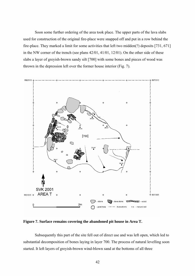
42
Soon some further ordering of the area took place. The upper parts of the lava slabs
used for construction of the original fire-place were snapped off and put in a row behind the
fire-place. They marked a limit for some activities that left two midden(?) deposits [731, 671]
in the NW corner of the trench (see plans 42/01, 41/01, 12/01). On the other side of these
slabs a layer of greyish-brown sandy silt [700] with some bones and pieces of wood was
thrown in the depression left over the former house interior (Fig. 7).
Figure 7. Surface remains covering the abandoned pit house in Area T.
Subsequently this part of the site fell out of direct use and was left open, which led to
substantial decomposition of bones laying in layer 700. The process of natural levelling soon
started. It left layers of greyish-brown wind-blown sand at the bottoms of all three
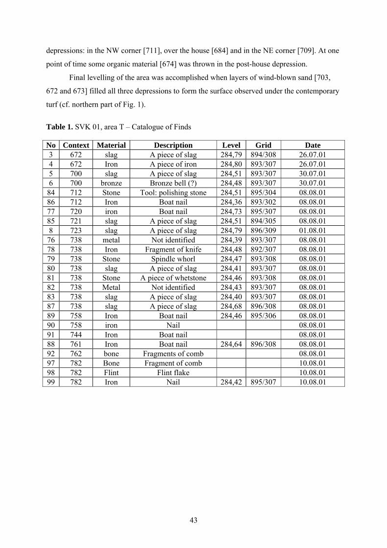
43
depressions: in the NW corner [711], over the house [684] and in the NE corner [709]. At one
point of time some organic material [674] was thrown in the post-house depression.
Final levelling of the area was accomplished when layers of wind-blown sand [703,
672 and 673] filled all three depressions to form the surface observed under the contemporary
turf (cf. northern part of Fig. 1).
Table 1. SVK 01, area T – Catalogue of Finds No Context Material Description Level Grid Date 3 672 slag A piece of slag 284,79 894/308 26.07.01 4 672 Iron A piece of iron 284,80 893/307 26.07.01 5 700 slag A piece of slag 284,51 893/307 30.07.01 6 700 bronze Bronze bell (?) 284,48 893/307 30.07.01 84 712 Stone Tool: polishing stone 284,51 895/304 08.08.01 86 712 Iron Boat nail 284,36 893/302 08.08.01 77 720 iron Boat nail 284,73 895/307 08.08.01 85 721 slag A piece of slag 284,51 894/305 08.08.01 8 723 slag A piece of slag 284,79 896/309 01.08.01 76 738 metal Not identified 284,39 893/307 08.08.01 78 738 Iron Fragment of knife 284,48 892/307 08.08.01 79 738 Stone Spindle whorl 284,47 893/308 08.08.01 80 738 slag A piece of slag 284,41 893/307 08.08.01 81 738 Stone A piece of whetstone 284,46 893/308 08.08.01 82 738 Metal Not identified 284,43 893/307 08.08.01 83 738 slag A piece of slag 284,40 893/307 08.08.01 87 738 slag A piece of slag 284,68 896/308 08.08.01 89 758 Iron Boat nail 284,46 895/306 08.08.01 90 758 iron Nail 08.08.01 91 744 Iron Boat nail 08.08.01 88 761 Iron Boat nail 284,64 896/308 08.08.01 92 762 bone Fragments of comb 08.08.01 97 782 Bone Fragment of comb 10.08.01 98 782 Flint Flint flake 10.08.01 99 782 Iron Nail 284,42 895/307 10.08.01
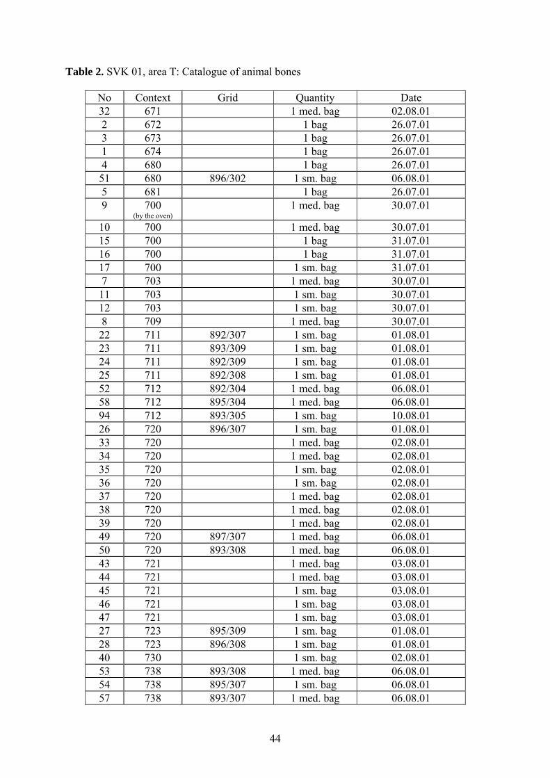
44
Table 2. SVK 01, area T: Catalogue of animal bones
No Context Grid Quantity Date 32 671 1 med. bag 02.08.01 2 672 1 bag 26.07.01 3 673 1 bag 26.07.01 1 674 1 bag 26.07.01 4 680 1 bag 26.07.01 51 680 896/302 1 sm. bag 06.08.01 5 681 1 bag 26.07.01 9 700
(by the oven) 1 med. bag 30.07.01
10 700 1 med. bag 30.07.01 15 700 1 bag 31.07.01 16 700 1 bag 31.07.01 17 700 1 sm. bag 31.07.01 7 703 1 med. bag 30.07.01 11 703 1 sm. bag 30.07.01 12 703 1 sm. bag 30.07.01 8 709 1 med. bag 30.07.01 22 711 892/307 1 sm. bag 01.08.01 23 711 893/309 1 sm. bag 01.08.01 24 711 892/309 1 sm. bag 01.08.01 25 711 892/308 1 sm. bag 01.08.01 52 712 892/304 1 med. bag 06.08.01 58 712 895/304 1 med. bag 06.08.01 94 712 893/305 1 sm. bag 10.08.01 26 720 896/307 1 sm. bag 01.08.01 33 720 1 med. bag 02.08.01 34 720 1 med. bag 02.08.01 35 720 1 sm. bag 02.08.01 36 720 1 sm. bag 02.08.01 37 720 1 med. bag 02.08.01 38 720 1 med. bag 02.08.01 39 720 1 med. bag 02.08.01 49 720 897/307 1 med. bag 06.08.01 50 720 893/308 1 med. bag 06.08.01 43 721 1 med. bag 03.08.01 44 721 1 med. bag 03.08.01 45 721 1 sm. bag 03.08.01 46 721 1 sm. bag 03.08.01 47 721 1 sm. bag 03.08.01 27 723 895/309 1 sm. bag 01.08.01 28 723 896/308 1 sm. bag 01.08.01 40 730 1 sm. bag 02.08.01 53 738 893/308 1 med. bag 06.08.01 54 738 895/307 1 sm. bag 06.08.01 57 738 893/307 1 med. bag 06.08.01
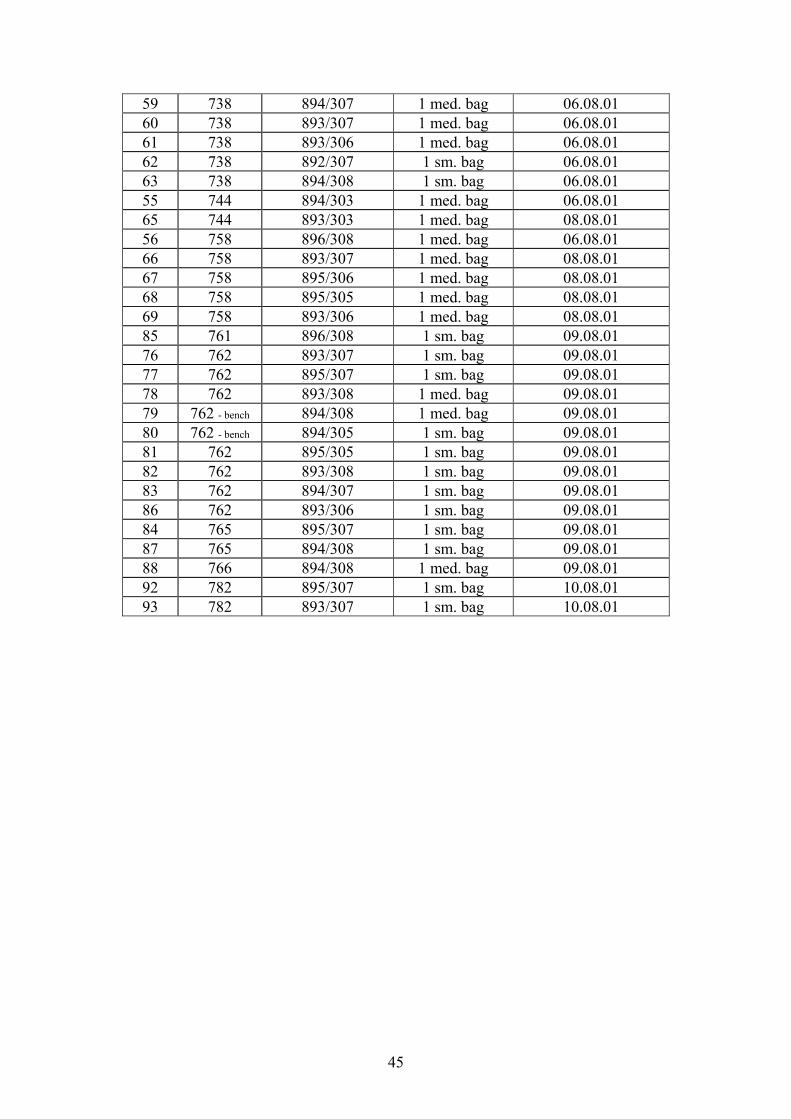
45
59 738 894/307 1 med. bag 06.08.01 60 738 893/307 1 med. bag 06.08.01 61 738 893/306 1 med. bag 06.08.01 62 738 892/307 1 sm. bag 06.08.01 63 738 894/308 1 sm. bag 06.08.01 55 744 894/303 1 med. bag 06.08.01 65 744 893/303 1 med. bag 08.08.01 56 758 896/308 1 med. bag 06.08.01 66 758 893/307 1 med. bag 08.08.01 67 758 895/306 1 med. bag 08.08.01 68 758 895/305 1 med. bag 08.08.01 69 758 893/306 1 med. bag 08.08.01 85 761 896/308 1 sm. bag 09.08.01 76 762 893/307 1 sm. bag 09.08.01 77 762 895/307 1 sm. bag 09.08.01 78 762 893/308 1 med. bag 09.08.01 79 762 - bench 894/308 1 med. bag 09.08.01 80 762 - bench 894/305 1 sm. bag 09.08.01 81 762 895/305 1 sm. bag 09.08.01 82 762 893/308 1 sm. bag 09.08.01 83 762 894/307 1 sm. bag 09.08.01 86 762 893/306 1 sm. bag 09.08.01 84 765 895/307 1 sm. bag 09.08.01 87 765 894/308 1 sm. bag 09.08.01 88 766 894/308 1 med. bag 09.08.01 92 782 895/307 1 sm. bag 10.08.01 93 782 893/307 1 sm. bag 10.08.01
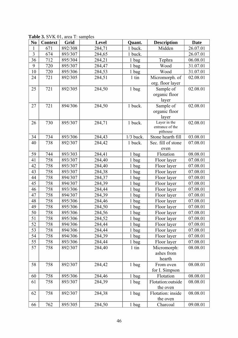
46
Table 3. SVK 01, area T: samples
No Context Grid Level Quant. Description Date 1 671 892/308 284,71 1 buck. Midden 26.07.01 3 674 893/307 284,65 1 buck. 26.07.01 36 712 895/304 284,21 1 bag Tephra 06.08.01 9 720 895/307 284,47 1 bag Wood 31.07.01 10 720 895/306 284,53 1 bag Wood 31.07.01 24 721 892/305 284,51 1 tin Micromorph. of
org. floor layer 02.08.01
25 721 892/305 284,50 1 bag Sample of organic floor
layer
02.08.01
27 721 894/306 284,50 1 buck. Sample of organic floor
layer
02.08.01
26 730 895/307 284,71 1 buck. Layer in the entrance of the
pithouse
02.08.01
34 734 893/306 284,43 1/3 buck. Stone hearth fill 03.08.01 40 738 892/307 284,42 1 buck. Sec. fill of stone
oven 07.08.01
59 744 893/303 284,41 1 bag Flotation 08.08.01 41 758 893/307 284,40 1 bag Floor layer 07.08.01 42 758 893/307 284,40 1 bag Floor layer 07.08.01 43 758 893/307 284,38 1 bag Floor layer 07.08.01 44 758 894/307 284,37 1 bag Floor layer 07.08.01 45 758 894/307 284,39 1 bag Floor layer 07.08.01 46 758 893/306 284,44 1 bag Floor layer 07.08.01 47 758 894/307 284,39 1 bag Floor layer 07.08.01 48 758 895/306 284,46 1 bag Floor layer 07.08.01 49 758 895/306 284,50 1 bag Floor layer 07.08.01 50 758 895/306 284,56 1 bag Floor layer 07.08.01 51 758 895/306 284,52 1 bag Floor layer 07.08.01 52 758 894/306 284,44 1 bag Floor layer 07.08.01 53 758 894/306 284,44 1 bag Floor layer 07.08.01 54 758 894/306 284,39 1 bag Floor layer 07.08.01 55 758 893/306 284,44 1 bag Floor layer 07.08.01 57 758 892/307 284,40 1 tin Micromorph:
ashes from hearth
08.08.01
58 758 892/307 284,42 1 bag From oven for I. Simpson
08.08.01
60 758 895/306 284,46 1 bag Flotation 08.08.01 61 758 893/307 284,39 1 bag Flotation:outside
the oven 08.08.01
62 758 892/307 284,38 1 bag Flotation: inside the oven
08.08.01
66 762 895/305 284,50 1 bag Charcoal 09.08.01
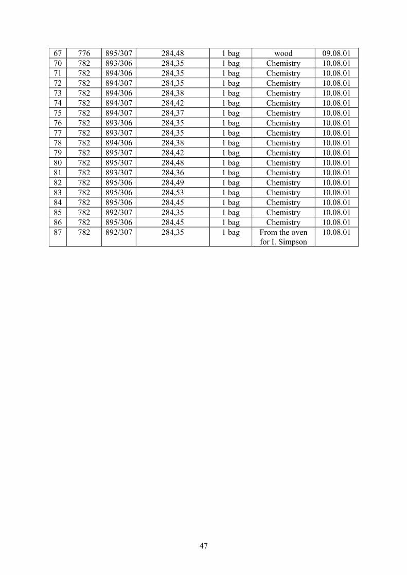
47
67 776 895/307 284,48 1 bag wood 09.08.01 70 782 893/306 284,35 1 bag Chemistry 10.08.01 71 782 894/306 284,35 1 bag Chemistry 10.08.01 72 782 894/307 284,35 1 bag Chemistry 10.08.01 73 782 894/306 284,38 1 bag Chemistry 10.08.01 74 782 894/307 284,42 1 bag Chemistry 10.08.01 75 782 894/307 284,37 1 bag Chemistry 10.08.01 76 782 893/306 284,35 1 bag Chemistry 10.08.01 77 782 893/307 284,35 1 bag Chemistry 10.08.01 78 782 894/306 284,38 1 bag Chemistry 10.08.01 79 782 895/307 284,42 1 bag Chemistry 10.08.01 80 782 895/307 284,48 1 bag Chemistry 10.08.01 81 782 893/307 284,36 1 bag Chemistry 10.08.01 82 782 895/306 284,49 1 bag Chemistry 10.08.01 83 782 895/306 284,53 1 bag Chemistry 10.08.01 84 782 895/306 284,45 1 bag Chemistry 10.08.01 85 782 892/307 284,35 1 bag Chemistry 10.08.01 86 782 895/306 284,45 1 bag Chemistry 10.08.01 87 782 892/307 284,35 1 bag From the oven
for I. Simpson 10.08.01
48
Table 4. SVK, Area T: catalogue of contexts Number Type Description Date
671 L Dark, gray-brown silt 25. 07. 01 672 L Dark, gray-brown silt with sand 25. 07. 01 673 L Dark, gray-black sand 25. 07. 01 674 L Mixed, orange-gray-black, silty sand 26. 07. 01 680 L Soft, dark, grayish-black silt 26. 07. 01 681 L Soft, dark, grayish-black silt 26. 07. 01 684 L Very dark, grayish-brown sand 26. 07. 01 693 L Fairy, dark reddish-brown and strong brown, silty sand 27. 07. 01 700 L Interior of the pithouse 27. 07. 01 703 L The fill layer of the pithouse 27. 07. 01 709 L Dark brown mixed with brown silty sand 30. 07. 01 711 L Soft, dark, mixed silty sand and tephra 30. 07. 01 712 L Soft, silky silt in three mixed colours with inclusions of
gray tephra 30. 07. 01
720 L Soft, very dark, reddish-brown sandy silt 31. 07. 01 721 L Clayish, dark, reddish-brown silt 31. 07. 01 723 L Soft, med. grayish-brown sandy silt 31. 07. 01 725 L Slightly soft, very dark, reddish-brown sandy silt 01. 08. 01 727 L Friable, pale, reddish-brown silky silt 01. 08. 01 730 L Friable, very dark, grayish-blackish-brown sandy silt 02.08. 01 731 L Light firm, dark, yellowish-brown sandy silt 02.08. 01 732 L External part of [721], separated by [738] – entrance of
the pithouse 02.08. 01
734 Hearth Fireplace built with lava-stones 03. 08. 01 738 L Floor-layer of the pithouse 03. 08. 01 743 L Soft, very dark, grayish-black silky sand 06. 08. 01 744 L Layer outside the pithouse – older than it 06. 08. 01 747 P. hole Soft, dark, gray silt 06. 08. 01 748 P. hole Very soft, dark, grayish-brown sandy silt 06. 08. 01 749 P. hole Soft, very dark, gray sandy silt 06. 08. 01 750 P. hole Soft, very dark, gray sandy silt 06. 08. 01 751 P. hole Soft, very dark, grayish-brown sandy silt 06. 08. 01 752 P. hole Soft, very dark, grayish-brown sandy silt 06. 08. 01 753 P. hole Soft, very dark, grayish-brown sandy silt 06. 08. 01 754 P. hole Friable, very dark, brown and brownish-black sand 06. 08. 01 755 P. hole Soft, very dark, grayish-brown sandy silt 06. 08. 01 756 P. hole Soft, very dark, grayish-brown sandy silt 06. 08. 01 757 Pit Soft, med. brown mixed with fair reddish-brown silt 06. 08. 01 758 L Floor-layer inside the pithouse 07. 08. 01 759 L Light firm, dark, yellowish-brown silty sand 07. 08. 01 761 L Silt and gravel with charcoal-ashes 08.08. 01 762 L Med. brownish-gray silt-layer inside the pithouse 08.08. 01 765 L First layer building “the bench” in the pithouse 08.08. 01 766 L Layer partly building “the bench” in the pithouse 08.08. 01 768 P. hole P. hole near the lava-stone oven in NW part of the 09. 08. 01
49
pithouse 769 P. hole Soft, very dark, grayish-brown silty sand 09. 08. 01 770 P. hole Soft, very dark, grayish-brown silty sand 09. 08. 01 771 P. hole Soft, very dark, brown silty sand 09. 08. 01 772 P. hole Soft, very dark, brown silty sand 09. 08. 01 773 P. hole Soft, very dark, brown silty sand 09. 08. 01 774 P. hole Soft, grayish-brown sandy silt 09. 08. 01 775 P. hole Soft, grayish-brown sandy silt 09. 08. 01 776 P. hole Soft, grayish-brown sandy silt 09. 08. 01 777 P. hole Friable, very dark, grayish-black sand with gravel 09. 08. 01 781 P. hole Soft, very dark, grayish-brown sand 09. 08. 01 782 L Second floor-layer inside the pithouse 09. 08. 01 783 P. hole Soft, very dark, gray sandy silt 09. 08. 01 795 L Soft, brown sandy silt 10. 08. 01 798 P. hole Soft, very dark, gray sandy silt 10. 08. 01 799 P. hole Appeared in the layer next to [801] (?) 10. 08. 01 800 L Third floor-layer in the pithouse 10. 08. 01 801 L Friable, mixed yellowish-brown sandy silt 10. 08. 01
50
Thomas H. McGovern
Sveigakot 2001. Area M - Midden
Summary: The 2001 summer season saw the conclusion of intensive excavation of the
midden unit M opened in 1999. The unit has produced a very substantial collection of well
preserved animal bone, charcoal, and over 75 registered artifacts of the Viking period. The
final season involved the excavation of a major western extension of the original unit in order
to trace more early “lower midden” material below the 007 tephra, and some renewed work
along the edges of the eastern squares first opened in 1999. This work recovered useful
quantities of bone from both areas and a range of additional artifacts, as well as an enigmatic
pit structure in the W extension. A pattern of six test pits spaced approx 5 m apart in the area
between M and the structure unit S found very little midden material in this area, but a
seventh pit (Unit P) revealed a sequence of low density midden, turf collapse, and an apparent
floor layer. While a great deal more remains to be done with the archaeology of Sveigakot, it
appears that the great bulk of the stratified midden has been cleared and priority can be given
to open area work aimed primarily at structural investigations.
Area M Extensions:
The back fill from profile edges is cleared and
additional 2 x 2 m units laid out at the W and N sides
of the 2000 western extension. At close of excavations
in 2000 this area continued to produce animal bone
from contexts directly upon the 009 tephra and below
the 007 tephra (lower midden). A major objective is to
recover more of this early material.
51
As the M unit is extended further W, the lower midden
layer (context 0049) thins progressively and the
midden breaks up into small pockets.
In the eastern end of the M unit, we extend the unit to
the S and E to recover more stratified material from
the upper midden layers above the
surface formed by the 007 tephra.
There is little or no midden material
from the lower midden between the
007 and 009 (Landnám?) tephra
sequence in this part of the M unit.
Some of the accumulation that
separates these midden deposits is
nearly sterile. Is it a natural wind
deposit? Where did it originate?
The E extension rapidly runs into
thinning upper midden covering an
irregular 007 surface, but bone and
artifacts are recovered in some
numbers from these squares.
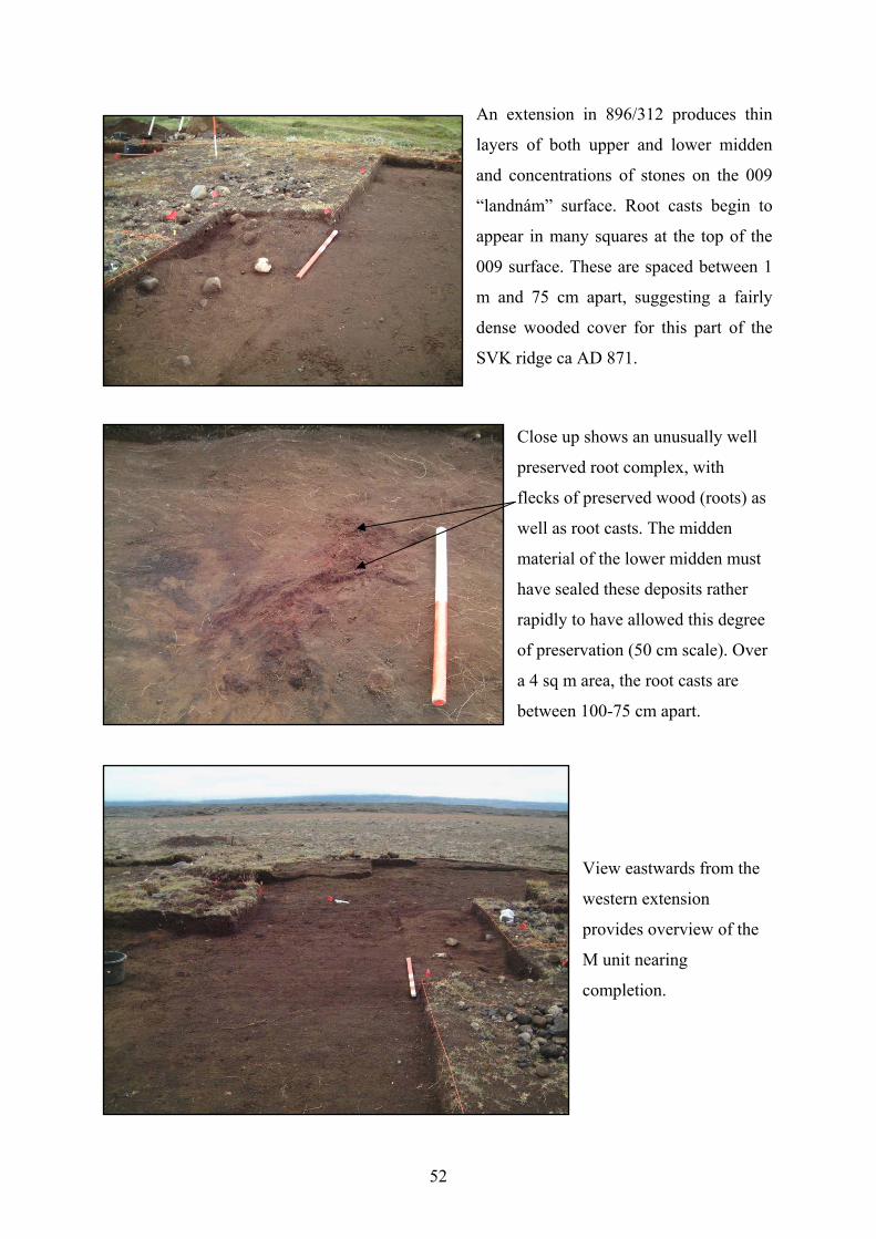
52
An extension in 896/312 produces thin
layers of both upper and lower midden
and concentrations of stones on the 009
“landnám” surface. Root casts begin to
appear in many squares at the top of the
009 surface. These are spaced between 1
m and 75 cm apart, suggesting a fairly
dense wooded cover for this part of the
SVK ridge ca AD 871.
Close up shows an unusually well
preserved root complex, with
flecks of preserved wood (roots) as
well as root casts. The midden
material of the lower midden must
have sealed these deposits rather
rapidly to have allowed this degree
of preservation (50 cm scale). Over
a 4 sq m area, the root casts are
between 100-75 cm apart.
View eastwards from the
western extension
provides overview of the
M unit nearing
completion.
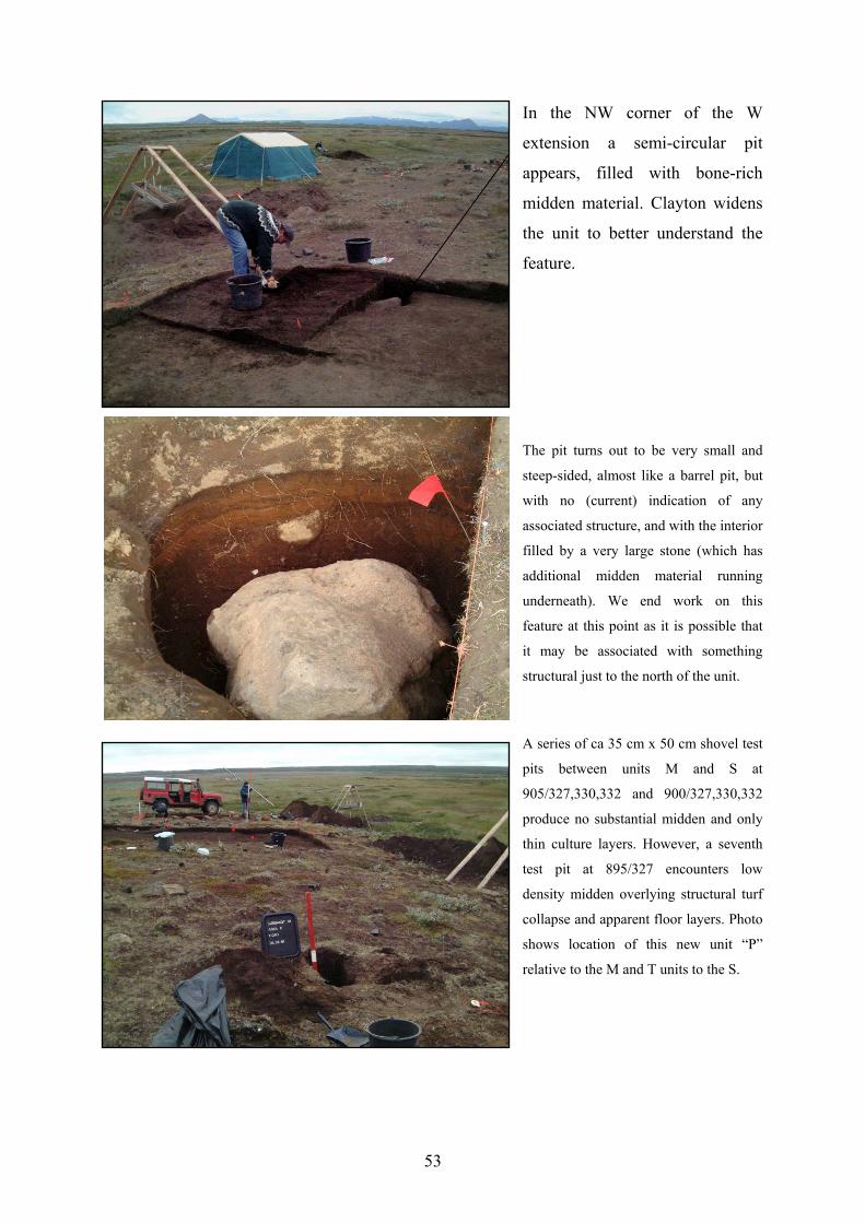
53
In the NW corner of the W
extension a semi-circular pit
appears, filled with bone-rich
midden material. Clayton widens
the unit to better understand the
feature.
The pit turns out to be very small and
steep-sided, almost like a barrel pit, but
with no (current) indication of any
associated structure, and with the interior
filled by a very large stone (which has
additional midden material running
underneath). We end work on this
feature at this point as it is possible that
it may be associated with something
structural just to the north of the unit.
A series of ca 35 cm x 50 cm shovel test
pits between units M and S at
905/327,330,332 and 900/327,330,332
produce no substantial midden and only
thin culture layers. However, a seventh
test pit at 895/327 encounters low
density midden overlying structural turf
collapse and apparent floor layers. Photo
shows location of this new unit “P”
relative to the M and T units to the S.
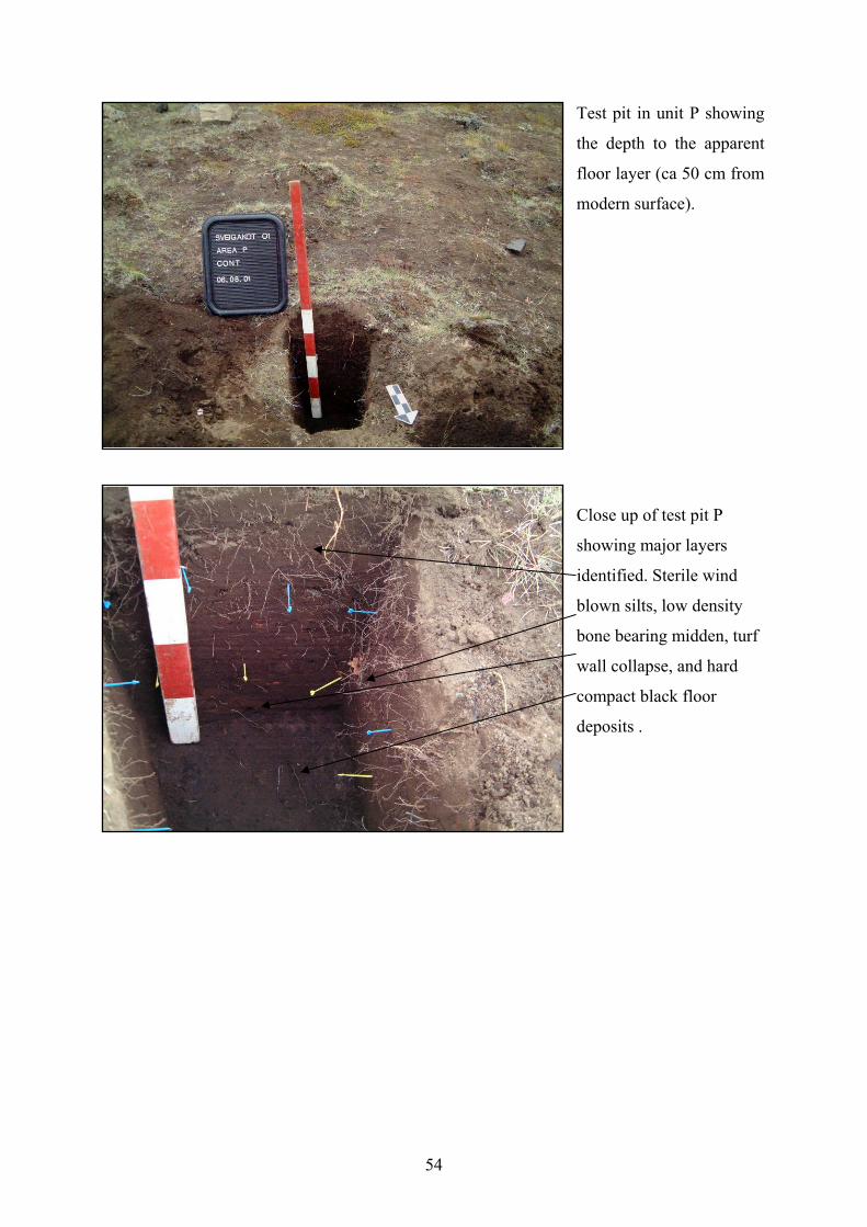
54
Test pit in unit P showing
the depth to the apparent
floor layer (ca 50 cm from
modern surface).
Close up of test pit P
showing major layers
identified. Sterile wind
blown silts, low density
bone bearing midden, turf
wall collapse, and hard
compact black floor
deposits .
55
Base of test pit P
showing possible floor
layers, turf collapse, and
midden material.
Summary and Recommendations
Additional midden material will probably be encountered in and around structure units T and
S, and it seems likely that additional low-density midden (mainly lower midden) extends
along much of the edge of the ridge between T and S (and taking in the structure or structures
around unit P). It is also possible that bone middens may lie under the 1.5-2 m of later water
borne sediments along the base of the medieval ridge. However, it appears that the major
midden concentrations of upper and lower midden that we have excavated under unit M are
now fairly completely removed and that there is no longer need for a permanent on site
middens team. These midden layers in area M have been extremely productive, and their near
contemporary dating to the midden deposits at HST present us with an excellent opportunity
to compare farms in the same district.
We recommend that the teams continuing the excavations at SVK simply continue their
current practice of documenting and excavating small midden deposits and bone
concentrations as they are recognized (as per standard FSÍ recovery standards), while
maintaining a sort of “watching brief” for any larger midden concentrations along the W edge
of the SVK ridge.
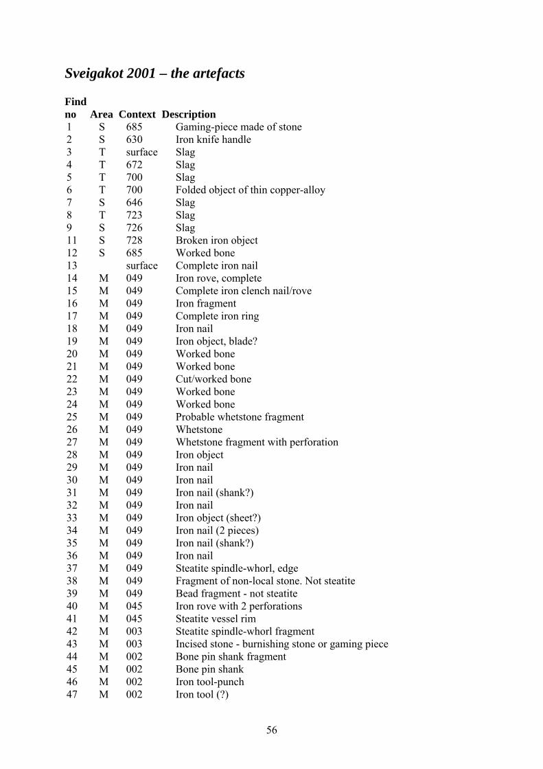
56
Sveigakot 2001 – the artefacts
Find no Area Context Description 1 S 685 Gaming-piece made of stone 2 S 630 Iron knife handle 3 T surface Slag 4 T 672 Slag 5 T 700 Slag 6 T 700 Folded object of thin copper-alloy 7 S 646 Slag 8 T 723 Slag 9 S 726 Slag 11 S 728 Broken iron object 12 S 685 Worked bone 13 surface Complete iron nail 14 M 049 Iron rove, complete 15 M 049 Complete iron clench nail/rove 16 M 049 Iron fragment 17 M 049 Complete iron ring 18 M 049 Iron nail 19 M 049 Iron object, blade? 20 M 049 Worked bone 21 M 049 Worked bone 22 M 049 Cut/worked bone 23 M 049 Worked bone 24 M 049 Worked bone 25 M 049 Probable whetstone fragment 26 M 049 Whetstone 27 M 049 Whetstone fragment with perforation 28 M 049 Iron object 29 M 049 Iron nail 30 M 049 Iron nail 31 M 049 Iron nail (shank?) 32 M 049 Iron nail 33 M 049 Iron object (sheet?) 34 M 049 Iron nail (2 pieces) 35 M 049 Iron nail (shank?) 36 M 049 Iron nail 37 M 049 Steatite spindle-whorl, edge 38 M 049 Fragment of non-local stone. Not steatite 39 M 049 Bead fragment - not steatite 40 M 045 Iron rove with 2 perforations 41 M 045 Steatite vessel rim 42 M 003 Steatite spindle-whorl fragment 43 M 003 Incised stone - burnishing stone or gaming piece 44 M 002 Bone pin shank fragment 45 M 002 Bone pin shank 46 M 002 Iron tool-punch 47 M 002 Iron tool (?)
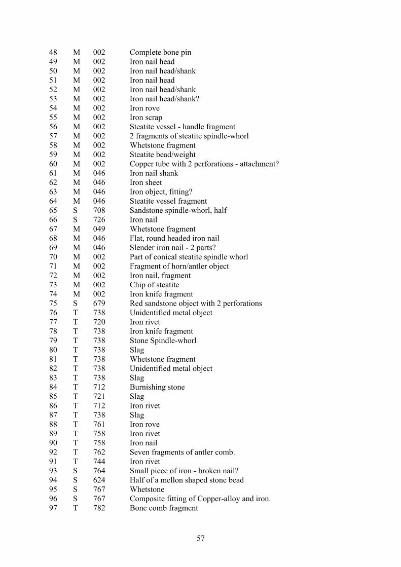
57
48 M 002 Complete bone pin 49 M 002 Iron nail head 50 M 002 Iron nail head/shank 51 M 002 Iron nail head 52 M 002 Iron nail head/shank 53 M 002 Iron nail head/shank? 54 M 002 Iron rove 55 M 002 Iron scrap 56 M 002 Steatite vessel - handle fragment 57 M 002 2 fragments of steatite spindle-whorl 58 M 002 Whetstone fragment 59 M 002 Steatite bead/weight 60 M 002 Copper tube with 2 perforations - attachment? 61 M 046 Iron nail shank 62 M 046 Iron sheet 63 M 046 Iron object, fitting? 64 M 046 Steatite vessel fragment 65 S 708 Sandstone spindle-whorl, half 66 S 726 Iron nail 67 M 049 Whetstone fragment 68 M 046 Flat, round headed iron nail 69 M 046 Slender iron nail - 2 parts? 70 M 002 Part of conical steatite spindle whorl 71 M 002 Fragment of horn/antler object 72 M 002 Iron nail, fragment 73 M 002 Chip of steatite 74 M 002 Iron knife fragment 75 S 679 Red sandstone object with 2 perforations 76 T 738 Unidentified metal object 77 T 720 Iron rivet 78 T 738 Iron knife fragment 79 T 738 Stone Spindle-whorl 80 T 738 Slag 81 T 738 Whetstone fragment 82 T 738 Unidentified metal object 83 T 738 Slag 84 T 712 Burnishing stone 85 T 721 Slag 86 T 712 Iron rivet 87 T 738 Slag 88 T 761 Iron rove 89 T 758 Iron rivet 90 T 758 Iron nail 92 T 762 Seven fragments of antler comb. 91 T 744 Iron rivet 93 S 764 Small piece of iron - broken nail? 94 S 624 Half of a mellon shaped stone bead 95 S 767 Whetstone 96 S 767 Composite fitting of Copper-alloy and iron. 97 T 782 Bone comb fragment
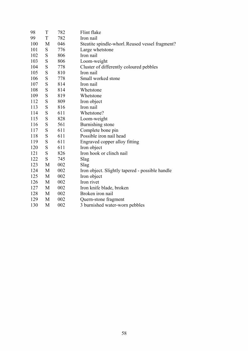
58
98 T 782 Flint flake 99 T 782 Iron nail 100 M 046 Steatite spindle-whorl. Reused vessel fragment? 101 S 776 Large whetstone 102 S 806 Iron nail 103 S 806 Loom-weight 104 S 778 Cluster of differently coloured pebbles 105 S 810 Iron nail 106 S 778 Small worked stone 107 S 814 Iron nail 108 S 814 Whetstone 109 S 819 Whetstone 112 S 809 Iron object 113 S 816 Iron nail 114 S 611 Whetstone? 115 S 828 Loom-weight 116 S 561 Burnishing stone 117 S 611 Complete bone pin 118 S 611 Possible iron nail head 119 S 611 Engraved copper alloy fitting 120 S 611 Iron object 121 S 826 Iron hook or clinch nail 122 S 745 Slag 123 M 002 Slag 124 M 002 Iron object. Slightly tapered - possible handle 125 M 002 Iron object 126 M 002 Iron rivet 127 M 002 Iron knife blade, broken 128 M 002 Broken iron nail 129 M 002 Quern-stone fragment 130 M 002 3 burnished water-worn pebbles
59
Orri Vésteinsson
Hrísheimar – the structures
The site Hrísheimar is on the property of the farm Baldursheimur, the southernmost of the
farms presently occupied in Mývatnssveit on the western side of river Kráká. The site is
some 2,5 west of Baldursheimur and 6,5 km south of lake Mývatn, at 65°30.817 N 17°06.452
W. It is 10 km from Hofstaðir and some 4,5 km from Sveigakot but while it is about the same
distance from Lake Mývatn as Sveigakot it is at a somewhat higher elevation, at 313 m a.s.l.
compared to 286 m a.s.l. at Sveigakot.
Hrísheimar is only some 100 m south of the river Gautlandalækur which separates the
properties of Baldursheimur and Gautlönd. On the northern side of that small river is the
present farm Heiði, founded in 1958 a short distance form the earlier farm site Bjarnastaðir.
Bjarnastaðir is mentioned in the land register of 1712 as a long abandoned farm on the
property of Gautlönd (JÁM XI, 224). Bjarnastaðir was occupied again shortly before 1850 in
a wave of new farm foundations on the moorlands inland from Mývatnssveit and Bárðardalur
but was abandoned in 1945. The site of the 19th century farm is still recognisable in a
levelled hay field belonging to Heiði (65°32.045 N 17°07.775 W). It presumably covers the
remains of the pre-1712 dwellings. Bjarnastaðir is another potential early site and may have
been occupied at the same time as Hrísheimar. With Baldursheimur and Þorleifsstaðir to the
south these two sites represent a potential settlement cluster of medieval date. The proximity
of Bjarnastaðir and Hrísheimar is potentially significant although the two settlements are
clearly separated by Gautlandalækur and a low ridge which obscures view between the farm
sites.
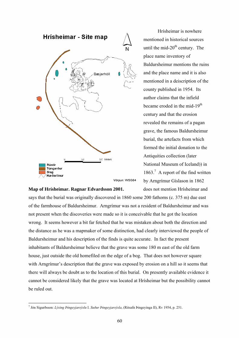
60
Hrísheimar is nowhere
mentioned in historical sources
until the mid-20th century. The
place name inventory of
Baldursheimur mentions the ruins
and the place name and it is also
mentioned in a deiscription of the
county published in 1954. Its
author claims that the infield
became eroded in the mid-19th
century and that the erosion
revealed the remains of a pagan
grave, the famous Baldursheimur
burial, the artefacts from which
formed the initial donation to the
Antiquities collection (later
National Museum of Iceland)) in
1863.7 A report of the find written
by Arngrímur Gíslason in 1862
Map of Hrísheimar. Ragnar Edvardsson 2001. does not mention Hrísheimar and
says that the burial was originally discovered in 1860 some 200 fathoms (c. 375 m) due east
of the farmhouse of Baldursheimur. Arngrímur was not a resident of Baldursheimur and was
not present when the discoveries were made so it is conceivable that he got the location
wrong. It seems however a bit far fetched that he was mistaken about both the direction and
the distance as he was a mapmaker of some distinction, had clearly interviewed the people of
Baldursheimur and his description of the finds is quite accurate. In fact the present
inhabitants of Baldursheimur believe that the grave was some 180 m east of the old farm
house, just outside the old homefiled on the edge of a bog. That does not however square
with Arngrímur’s description that the grave was exposed by erosion on a hill so it seems that
there will always be doubt as to the location of this burial. On presently available evidence it
cannot be considered likely that the grave was located at Hrísheimar but the possibility cannot
be ruled out.
7 Jón Sigurðsson: Lýsing Þingeyjarsýslu I. Suður Þingeyjarsýsla, (Ritsafn Þingeyinga II), Rv 1954, p. 251.
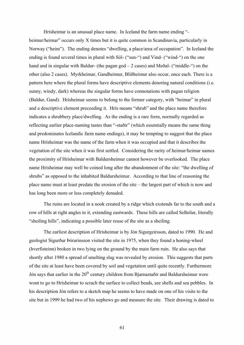
61
Hrísheimar is an unusual place name. In Iceland the farm name ending “-
heimur/heimar” occurs only X times but it is quite common in Scandinavia, particularly in
Norway (“heim”). The ending denotes “dwelling, a place/area of occupation”. In Iceland the
ending is found several times in plural with Sól- (“sun-“) and Vind- (“wind-“) on the one
hand and in singular with Baldur- (the pagan god – 2 cases) and Meðal- (“middle-“) on the
other (also 2 cases). Myrkheimar, Gandheimur, Blíðheimur also occur, once each. There is a
pattern here where the plural forms have descriptive elements denoting natural conditions (i.e.
sunny, windy, dark) whereas the singular forms have connotations with pagan religion
(Baldur, Gand). Hrísheimar seems to belong to the former category, with “heimar” in plural
and a descriptive element preceeding it. Hrís means “shrub” and the place name therefore
indicates a shrubbery place/dwelling. As the ending is a rare form, normally regarded as
reflecting earlier place-naming tastes than “-staðir” (which essentially means the same thing
and predominates Icelandic farm name endings), it may be tempting to suggest that the place
name Hrísheimar was the name of the farm when it was occupied and that it describes the
vegetation of the site when it was first settled. Considering the rarity of heimur/heimar names
the proximity of Hrísheimar with Baldursheimur cannot however be overlooked. The place
name Hrísheimar may well be coined long after the abandonment of the site: “the dwelling of
shrubs” as opposed to the inhabited Baldursheimur. According to that line of reasoning the
place name must at least predate the erosion of the site – the largest part of which is now and
has long been more or less completely denuded.
The ruins are located in a nook created by a ridge which exstends far to the south and a
row of hills at right angles to it, extending eastwards. These hills are called Selhólar, literally
“sheiling hills”, indicating a possible later reuse of the site as a sheiling.
The earliest description of Hrísheimar is by Jón Sigurgeirsson, dated to 1990. He and
geologist Sigurður Þórarinsson visited the site in 1975, when they found a honing-wheel
(hverfisteinn) broken in two lying on the ground by the main farm ruin. He also says that
shortly after 1980 a spread of smelting slag was revealed by erosion. This suggests that parts
of the site at least have been covered by soil and vegetation until quite recently. Furthermore
Jón says that earlier in the 20th century children from Bjarnastaðir and Baldursheimur were
wont to go to Hrísheimar to scrach the surface to collect beads, see shells and sea pebbles. In
his description Jón refers to a sketch map he seems to have made on one of his visits to the
site but in 1999 he had two of his nephews go and measure the site. Their drawing is dated to
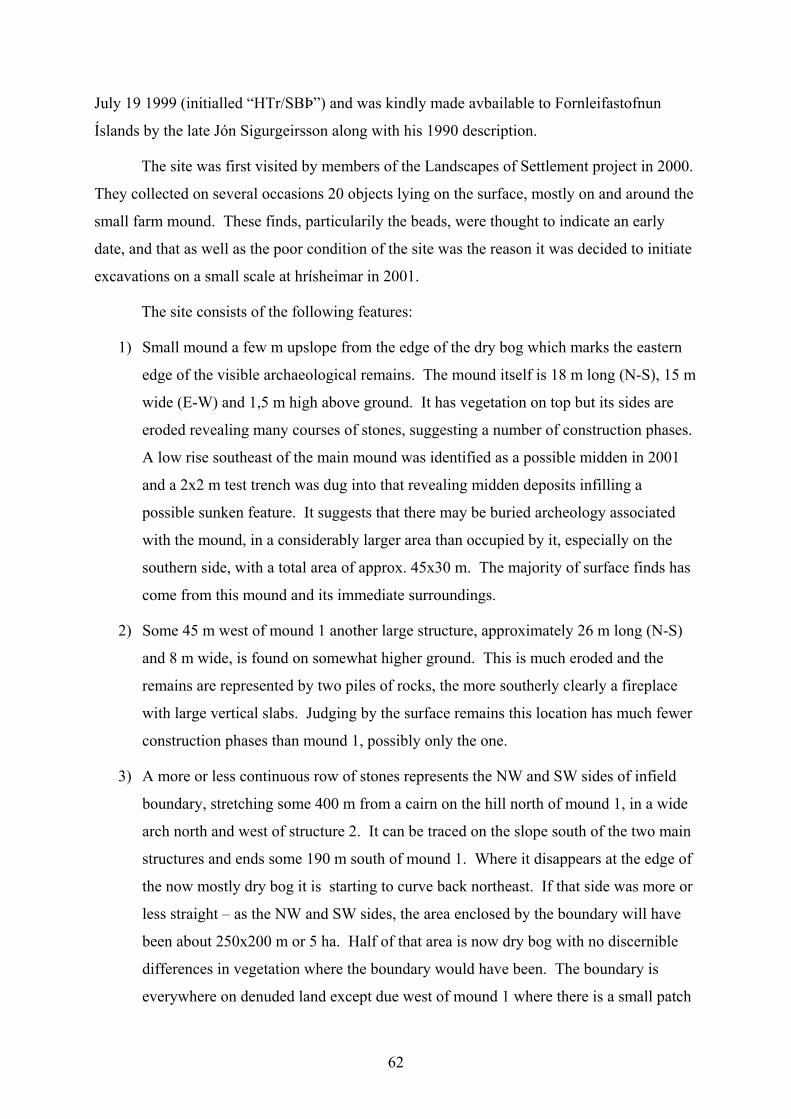
62
July 19 1999 (initialled “HTr/SBÞ”) and was kindly made avbailable to Fornleifastofnun
Íslands by the late Jón Sigurgeirsson along with his 1990 description.
The site was first visited by members of the Landscapes of Settlement project in 2000.
They collected on several occasions 20 objects lying on the surface, mostly on and around the
small farm mound. These finds, particularily the beads, were thought to indicate an early
date, and that as well as the poor condition of the site was the reason it was decided to initiate
excavations on a small scale at hrísheimar in 2001.
The site consists of the following features:
1) Small mound a few m upslope from the edge of the dry bog which marks the eastern
edge of the visible archaeological remains. The mound itself is 18 m long (N-S), 15 m
wide (E-W) and 1,5 m high above ground. It has vegetation on top but its sides are
eroded revealing many courses of stones, suggesting a number of construction phases.
A low rise southeast of the main mound was identified as a possible midden in 2001
and a 2x2 m test trench was dug into that revealing midden deposits infilling a
possible sunken feature. It suggests that there may be buried archeology associated
with the mound, in a considerably larger area than occupied by it, especially on the
southern side, with a total area of approx. 45x30 m. The majority of surface finds has
come from this mound and its immediate surroundings.
2) Some 45 m west of mound 1 another large structure, approximately 26 m long (N-S)
and 8 m wide, is found on somewhat higher ground. This is much eroded and the
remains are represented by two piles of rocks, the more southerly clearly a fireplace
with large vertical slabs. Judging by the surface remains this location has much fewer
construction phases than mound 1, possibly only the one.
3) A more or less continuous row of stones represents the NW and SW sides of infield
boundary, stretching some 400 m from a cairn on the hill north of mound 1, in a wide
arch north and west of structure 2. It can be traced on the slope south of the two main
structures and ends some 190 m south of mound 1. Where it disappears at the edge of
the now mostly dry bog it is starting to curve back northeast. If that side was more or
less straight – as the NW and SW sides, the area enclosed by the boundary will have
been about 250x200 m or 5 ha. Half of that area is now dry bog with no discernible
differences in vegetation where the boundary would have been. The boundary is
everywhere on denuded land except due west of mound 1 where there is a small patch
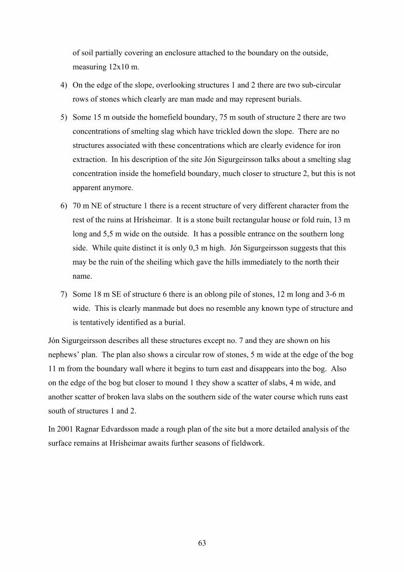
63
of soil partially covering an enclosure attached to the boundary on the outside,
measuring 12x10 m.
4) On the edge of the slope, overlooking structures 1 and 2 there are two sub-circular
rows of stones which clearly are man made and may represent burials.
5) Some 15 m outside the homefield boundary, 75 m south of structure 2 there are two
concentrations of smelting slag which have trickled down the slope. There are no
structures associated with these concentrations which are clearly evidence for iron
extraction. In his description of the site Jón Sigurgeirsson talks about a smelting slag
concentration inside the homefield boundary, much closer to structure 2, but this is not
apparent anymore.
6) 70 m NE of structure 1 there is a recent structure of very different character from the
rest of the ruins at Hrísheimar. It is a stone built rectangular house or fold ruin, 13 m
long and 5,5 m wide on the outside. It has a possible entrance on the southern long
side. While quite distinct it is only 0,3 m high. Jón Sigurgeirsson suggests that this
may be the ruin of the sheiling which gave the hills immediately to the north their
name.
7) Some 18 m SE of structure 6 there is an oblong pile of stones, 12 m long and 3-6 m
wide. This is clearly manmade but does no resemble any known type of structure and
is tentatively identified as a burial.
Jón Sigurgeirsson describes all these structures except no. 7 and they are shown on his
nephews’ plan. The plan also shows a circular row of stones, 5 m wide at the edge of the bog
11 m from the boundary wall where it begins to turn east and disappears into the bog. Also
on the edge of the bog but closer to mound 1 they show a scatter of slabs, 4 m wide, and
another scatter of broken lava slabs on the southern side of the water course which runs east
south of structures 1 and 2.
In 2001 Ragnar Edvardsson made a rough plan of the site but a more detailed analysis of the
surface remains at Hrísheimar awaits further seasons of fieldwork.
64
Thomas H. McGovern & Clayton Tinsley
Report on Midden Investigations at Hrísheimar
Summary: Investigations at the abandoned farm site of Hrísheimur revealed well stratified
midden deposits up to 60 cm thick. These deposits apparently fill a semi-subterranean
structure with partially intact floor layers and some surviving structural elements. Conditions
of bone preservation are good to excellent, and potential for coordinated investigation with
geological and structures teams seems considerable.
Objectives
The objectives of the 2001 archaeological and environmental investigations at Hrísheimar
(HRH) were:
• Determine conditions of organic preservation
• Determine if stratified midden deposits remained intact anywhere on site
• Collect small samples of bone for zooarchaeological analysis
• Collect any datable artifacts
• Cooperate with geo teams in assessing tephra and geo-archaeology potential
• Set up grid, begin mapping structures and land contours.
Investigations 2001
Beginning work July 25th with a preliminary inspection and finishing concentrated work
August 6-10, a small team consisting of Clayton Tinsley, Tom McGovern, Anthony Newton,
Eric Seadale, and Eliza McGovern carried out a first stage investigation of the midden area of
the site. Surface collection on July 25th revealed a concentration of bone and ash in and
around a series of semi-stabilized erosion dunes to the SE (generally lee-ward) side of the
mounded farm ruin. This area seemed to offer the best potential for surviving stratigraphy on
65
this very heavily eroded site (see attached illustrations). We laid out a N-S major grid axis
with a center point at 1000/1100. We used this point as the SW corner for a 2 x 2 m test unit
(Unit H) approximately centered on the exposed bone and charcoal. Beneath a layer of wind
deposited sterile silt (001) we rapidly encountered bone bearing midden deposits. We cleared
off the sterile, then (when full scale work resumed Aug 6th ) began excavation of the Eastward
two meter squares (1001 line). All excavated material was put through 4 mm mesh dry sieve
and major whole-soil samples were saved for flotation as per NABO/FSÍ recommended
practice. These two squares turned up an impressive amount of well preserved animal bone,
fire cracked stones, wood charcoal, and ash. Species immediately identifiable included
haddock, cod, salmonid fish, bird (probably ptarmigan), cattle, sheep, and pig (including
several maxillae). No biperforated metapodials were noted (a butchery practice common only
after ca AD 1100). Below these upper midden layers (002-004), we encountered a widespread
layer of displaced structural turf fragments in random orientation. These contained large
amounts of a gray tephra superficially resembling the 007 deposit at Sveigakot across the
Kraká. Below these deposits we encountered more midden layers with quantities of slightly
less well preserved animal bone and much wood charcoal and fire cracked rock. Below these
lower midden deposits we again encountered a layer of displaced turf debris (with extensive
inclusion of gray tephra). C14 samples (cattle bone) were collected from midden layers
above and below the turf collapse layers. As we began to cut into this lower turf collapse
surface, we rapidly discovered patches of what appeared to be highly compacted, hard dark
surfaced material similar to floor layers seen on other sites nearby. After cutting into these
layers in a small area along the 1102 E-W profile (HRH drawing 2) we stopped excavation in
the eastern side of the H unit. We then expanded the excavation area, taking in the remaining
(Western) 2 meters. These excavations revealed the same sequence of layers, while
demonstrating that they sloped sharply from a high point near the 1000/1102 grid point. This
point rapidly revealed what appears to be upcast tan sterile soil flecked with patches of white
tephra, very much like the upcast bank around feature G at Hofstađir. This upcast was
covered by the lower turf collapse and the midden layers above. We did not excavate into this
layer, but instead followed the contours of the top of the lower turf collapse layer. Near the W
wall of the unit H, we encountered what appears to be a small post mould filled with loose
brown soil. This was not emptied but marked with red pins and left intact for investigations
by the structures team. Finds include slag, some small fragments of gray schist whetstone
(and a large complete whetstone surface collected by Arní Einarsson and donated by him),
and a complete steatite spindle whorl (low bun-shaped). In combination with the glass beads
66
surface collected last year, these finds suggest a date broadly comparable to the occupation of
Sveigakot nearby. Major N-S and E-W profiles were drawn and extensive digital and film
photography took place throughout (see illustrations). Corings (Oakfield tube type soil corer)
indicated variable depths of organic material around the H unit area, with deepest
concentrations apparently to the N (upslope, see coring report). We aided the geo team in
excavating profiles off site, and they were successful in identifying a full range of tephras
close to the site area. We did not map the site, as it seemed more time-efficient and more
likely to produce consistently high quality data to have the FSÍ GPS survey team carry out
this task separately.
Conclusions
There is certainly excellent organic preservation at Hrísheimur, and while it is hard to
estimate the extent of the surviving midden deposits it seems that there is a substantial amount
preserved within and around a sunken feature structure. The parallels with associated midden
and sunken structures at Hofstađir and Sveigakot seem clear, and it would seem that a full
scale open area investigation will be needed to effectively remove the midden infilling and
multiple turf collapses from the apparent floor layers below. Despite its heavily eroded
condition, this early site has considerable potential for multi-disciplinary investigation.
Recommendations
• Expansion of midden excavations in the unit H area, open area with temporary baulks
or alternate square approaches to combine vertical and horizontal exposures. Continue
systematic sieving and whole soil sampling programs.
• Attempt to identify tephra held in displaced turf fragments.
• Attempt to connect tephra in geo trenches to the site excavation units.
• Full scale mapping and documentation of the many wall lines, cairns, and other
features visible in the eroded areas.
• Investigation of two large concentrations of smithing debris eroded out to the NW of
the main ruin.
• Eventual excavation of the exposed sunken feature in H.
67
Coring Report HRH Aug 7th 2001
A series of cores were taken with an Oakfield tube-type soil corer (with peat head) in the
immediate vicinity of the Midden unit H. As usual, a number of cores were stopped by stones
before showing much stratigraphy, and as ever one should be careful of over-interpretation of
such small exposures. However, it would appear from these results that while there is
substantial midden material present around H (esp to the N and E) there is not a continuous
band of midden in this area. I suspect multiple erosion events and some complexity. NB Grid
locations approximate.
Core 1 (within the H unit) 1001/1101
Surface – 10 cm windblown sterile silt
20 – 30 cm stratified midden deposit
30-35 cm (approx) gray tephra and turf mix
35-58 cm gray ash and midden material
Core 2 1003/1102 (E of H)
Surface- 25 cm organic deposit, possibly midden
25-45 cm sterile natural layers and tephra
Core 3 1001/1101
Surface- 15 cm organic deposit possibly midden
15-35 cm natural layers.
Core 4 998/1100
Surface-20 cm organic deposit possibly midden
20 cm- rock natural layers
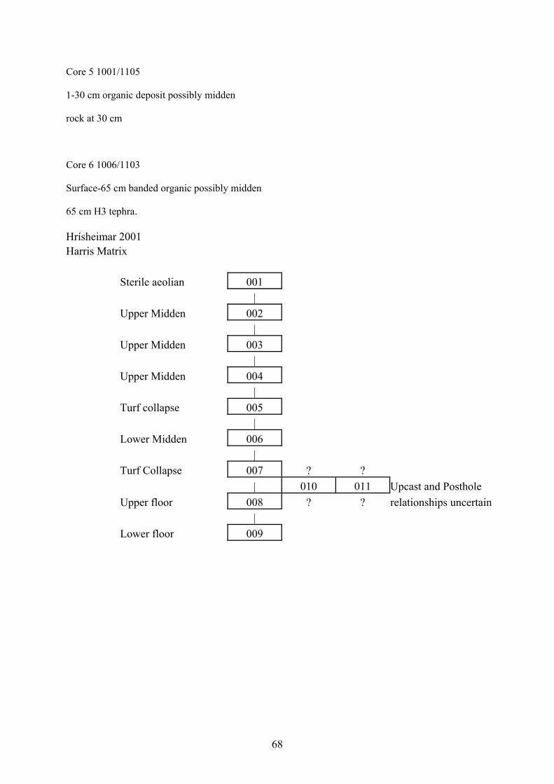
68
Core 5 1001/1105
1-30 cm organic deposit possibly midden
rock at 30 cm
Core 6 1006/1103
Surface-65 cm banded organic possibly midden
65 cm H3 tephra.
Hrísheimar 2001 Harris Matrix Sterile aeolian 001 | Upper Midden 002 | Upper Midden 003 | Upper Midden 004 | Turf collapse 005 | Lower Midden 006 | Turf Collapse 007 ? ? | 010 011 Upcast and Posthole Upper floor 008 ? ? relationships uncertain | Lower floor 009
69
Natascha Mehler Hrísheimar 2000 and 2001 – the finds. Preliminary Report The archaeological investigations at Hrísheimar (HRH) undertaken in the summers of 2000
and 2001 revealed a total amount of 68 artefacts, recorded with 34 find numbers: most of
them were collected by surveying the site surface in 2000, and some others were found during
the test-trench excavation of a midden deposit in august 2001. All finds were numbered in a
field finds list, and after cleaning registered in an excavation master-database including both
field seasons. The finds are made of various materials: glass, metal, stone and bone.
Preservation was good to excellent. Conservation was only needed for the whetstone
fragments HLH 029. All determinable objects such as hone fragments and beads are of
Viking age. Iron artefacts of more general Viking age and medieval character. The
composition of the material culture and the absence of certain artefacts such as ceramic can be
considered typically for Viking age sites in Iceland.
Metal objects
33 Metal objects were found and recorded with 14 numbers. Some indicate that iron
production has taken place at Hrisheimar. Several slag fragments were found, both smelting
and smithing slag. Five dark grey and rather heavy smelting slag pieces are recorded under
HLH 00-001, three little dark grey smelting slag pebbles under HLH 00-016. HRH 01-013
lists three small fragments of smithing slag and two fragments of iron. HRH 01-026 is another
lump of smithing slag. 8 Two other dark grey smelting slag fragments (HRH 00-015) are
shaped in a special way: the form looks like a rim fragment of a vessel. In- and outside bear
seams crossing in a 90° angel. Nine small iron fragments of unknown purpose were found
(HRH 00-012 and HRH 01-032), two of them could be part of a little knife blade (HRH 00-
012). HRH 00-011 seems to be the bent stem of a nail. HRH 01-030 is the fragment of a flat
iron sheet with a central hole. The object could be part of a clench bolt or a fitting. HRH 00-
010 are two fragments of a small knife or a shear. Blade and tang are partly preserved, both
ends are broken. HRH 01-033 is a little iron hook in rather good condition. HRH 01-028 is a
well preserved iron handle of 15.2 cm surviving length, possibly belonging to a wooden
8 The piece is listed in the field find list with number HRH 01-026 and has been photographed, but is missing; see picture.
70
vessel. The long and thin handle is made of twisted metal, one end is hook-like bent, the other
end is missing. HRH 00-014 is a long and pointy object of iron with a surviving length of 12.4
cm. One end is slightly bent and the other end is rectangular shaped. The artefact could be
part of a tool, maybe an awl. HRH 00-002 is the only non-ferrous metal find, a rectangular
fitting made of lead, now whitish corroded. The metal is folded on two sides and has been
pierced afterwards. Also this object could be part of a vessel.
Stone objects
32 objects of stone were recovered and recorded with 17 numbers. Stone types include quartz,
slate, schist, jaspis and sandstone which are often found also in other Icelandic Viking age
sites such as Aðalstræti.9 The stone objects represent domestic utensils as well as personal
belongings. Six stones are unworked. HRH 01-022 is a broken piece of most likely basalt type
that appeared to be man-worked when collected, as it is the case with HRH 00-006, a
fragment of red unworked sandstone. HRH 01-027 is a small round orange to beige pebble of
yet unknown stone type. HRH 01-024 and HRH 01-034 are two small and round yellowish to
opaque quartz pebbles. HRH 00-005 is another unworked piece of yellowish quartz. All
quartz examples seem to be man transported to Hrisheimar. Their purpose is unknown, they
could have been used as gaming pieces or toys.10 HRH 01-025 is a well preserved complete
spindle whorl made of grey sandstone. With its diameter of 3.8 cm and a weight of 36 g it is
similar to other Viking age sandstone spindle whorls known for example from Hofstaðir.11 Its
shape is hemispherical with a flat base and a maximum diameter at the base, the central hole
has a diameter of 1.0 cm. Two sides bear scratch marks. Due to the slightly inwards bent base,
the whorl appears to be a re-used fragment of a sandstone vessel. This is also supported by the
fact that most of sandstone spindle whorls found in Iceland so far are made of greenish-
greyish rhyolithe.12 Two flaked fragments of dark jaspis were found as well. HRH 00-003 is
of dark grey colour, HRH 00-004 is slightly lighter and greenish-greyish in colour. Jaspis is
often found in Viking age contexts and has been used as a fire starter.13 The remains of at
least six different hones were found, made of slate, fine and medium coarse schist. HRH 00-
009 is the only slate whetstone fragment. Two surfaces have survived, the colour is dark grey, 9 Mehler 2001, 69 f. 10 Most of the unworked stone objects found in Viking age contexts at Aðalstræti are of quartz as well. Mehler 2001, 70. 11 Bredenberg 1999, 98 f. 12 For example HST 98-115 and AST 01-739, AST 01-740, AST 01-743; see also Mehler 2001, 69. 13 Smith 2000, 217.
71
its shape flat rectangular. Whetstones made of slate appear more seldom compared to those
made of schist. A similar whetstone fragment of slate was found at Hofstaðir.14 Four of the
schist whetstone fragments are rather well preserved. They appear in various sizes and shapes.
The largest one, HRH 00-008 is a long rectangular barr-shaped whetstone fragment made of
medium-coarse and grey schist. Its surviving length is 10.1 cm, all surfaces are intact, one end
is broken off. Somewhat more fine and elaborate is HRH 01-021, a rectangular spindle shaped
whetstone made of light grey and fine schist. The object is thickest in the middle and tapering
towards both broken ends. All surfaces are intact, the length is 11.7 cm. Two other whetstone
fragments represent personal belongings rather than domestic utensils and are part of hone-
pendants. HRH 01-031 is the end of a rectangular shaped small whetstone made of light grey
and fine schist, all surfaces intact. HRH 00-007 is the end of a flat whetstone with a triangular
cross section, made of fine and light grey schist, as well all surfaces comlete. As comparative
material from the Viking age town Haithabu has shown, schist whetstones with a triangular
cross section are rather seldom.15 HRH 00-020 and HRH 01-029 are several fragments of
hones made of fine and light grey schist. The material is very fragmented, thus their original
form remains unknown. Another personal belonging is HRH 00-019, a small fragment of a
bead of red sandstone. Its shape seems to have been cylindrical. Beads made of sandstone are
rarely found since they were difficult to produce.
Glass objects
Two artefacts of glass were found, both of them very well preserved monochrome glass
beads. HRH 00-017 is a triple-segmented bead of dark blue colour with a half segment
missing. HRH 00-018 is a barrel shaped bead of dark blue colour, with a rather large hole
diameter of 0.5 cm. Both beads are macroscopically very similar in material and colour and it
is likely, that they were made together. The form types are rather common in the Viking
world and can be found at many sites in Northern Europe.16 Icelandic comparative material is
known for example from the viking burials in Vatnsdal, Mjóadal, Sílastaðir and Hrífunes,
whereas barrel shaped blue glass beads seem to be much more common than segmented blue
glass beads.17
14 Find number HST 98-118. 15 Resi 1990, 27. 16 The glass beads found in York were grouped according to their forms. HRH 00-017 corresponds with Type 7, HRH 00-018 with Type 5. See Mainman & Rogers 2000, 2591 f. 17 Kristján Eldjárn 2000, 103, 116, 180 and 247.
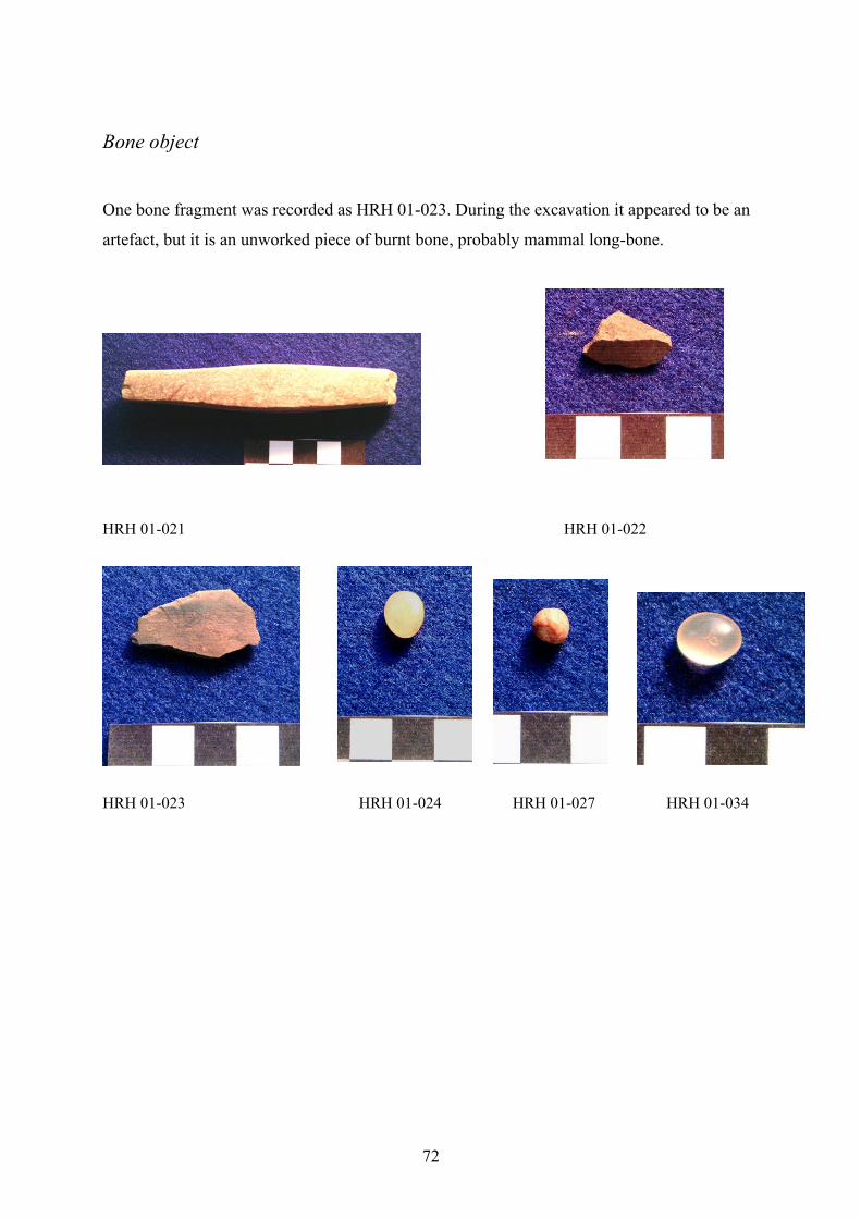
72
Bone object
One bone fragment was recorded as HRH 01-023. During the excavation it appeared to be an
artefact, but it is an unworked piece of burnt bone, probably mammal long-bone.
HRH 01-021 HRH 01-022
HRH 01-023 HRH 01-024 HRH 01-027 HRH 01-034
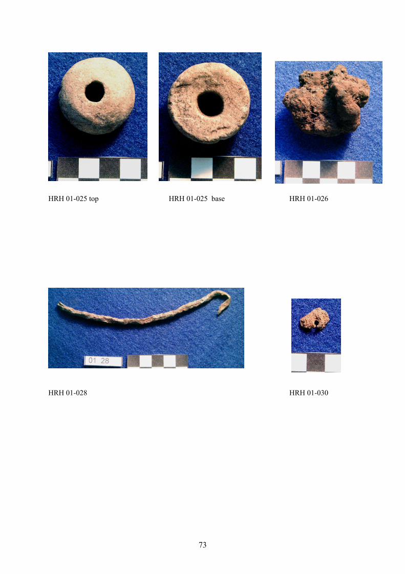
73
HRH 01-025 top HRH 01-025 base HRH 01-026
HRH 01-028 HRH 01-030
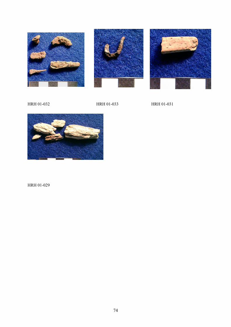
74
HRH 01-032 HRH 01-033 HRH 01-031
HRH 01-029
75
References
Bredenberg, J.
1999 Finds. In: Lucas, Gavin (ed.). Hofstaðir 1999. Framvinduskýrslur/Interim Report.
Fornleifastofnun Íslands FS102-91017, p. 94-111. Reykjavík.
Kristján Eldjárn (ed. Adolf Friðriksson)
2000 Kuml og haugfé úr heiðnum sið á Íslandi. 2. útgáfa. Reykjavík.
Mainman, A. J.; Rogers, N. S. H.
2000 Craft, Industry and Everyday Life: Finds from Anglo-Scandinavian York. The
Archaeology of York Volume 17/14: The Small Finds. York.
Mehler, Natascha
2001 The Finds. In: Roberts, Howell (ed.). Fornleifarannsókn á lóðunum/Archaeological
Excavations at Aðalstræti 14-18, 2001. A Preliminary Report/Framvinduskýrslur.
Fornleifastofnun Íslands FS156-00161, p. 68-83 and 126-157. Reykjavík.
Resi, Heid Gjöstein
1990 Die Wetz- und Schleifsteine aus Haithabu. Berichte über die Ausgrabungen in
Haithabu 28. Neumünster.
Smith, Kevin P.
2000 Jasper Cores from L´Anse aux Meadows. In: Fitzhugh, William W.; Ward, Elisabeth
I. Vikings. The North Atlantic Saga, p. 217. Washington.
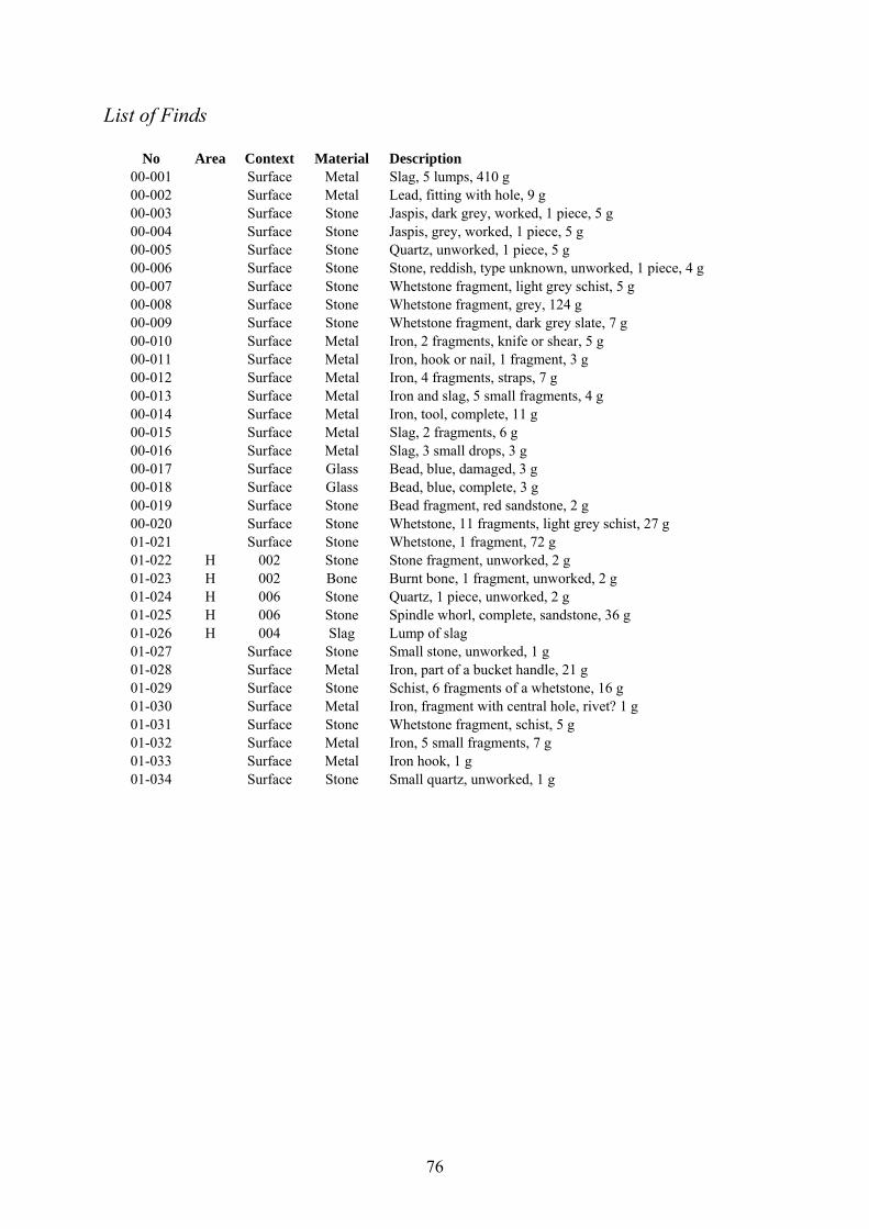
76
List of Finds
No Area Context Material Description 00-001 Surface Metal Slag, 5 lumps, 410 g 00-002 Surface Metal Lead, fitting with hole, 9 g 00-003 Surface Stone Jaspis, dark grey, worked, 1 piece, 5 g 00-004 Surface Stone Jaspis, grey, worked, 1 piece, 5 g 00-005 Surface Stone Quartz, unworked, 1 piece, 5 g 00-006 Surface Stone Stone, reddish, type unknown, unworked, 1 piece, 4 g 00-007 Surface Stone Whetstone fragment, light grey schist, 5 g 00-008 Surface Stone Whetstone fragment, grey, 124 g 00-009 Surface Stone Whetstone fragment, dark grey slate, 7 g 00-010 Surface Metal Iron, 2 fragments, knife or shear, 5 g 00-011 Surface Metal Iron, hook or nail, 1 fragment, 3 g 00-012 Surface Metal Iron, 4 fragments, straps, 7 g 00-013 Surface Metal Iron and slag, 5 small fragments, 4 g 00-014 Surface Metal Iron, tool, complete, 11 g 00-015 Surface Metal Slag, 2 fragments, 6 g 00-016 Surface Metal Slag, 3 small drops, 3 g 00-017 Surface Glass Bead, blue, damaged, 3 g 00-018 Surface Glass Bead, blue, complete, 3 g 00-019 Surface Stone Bead fragment, red sandstone, 2 g 00-020 Surface Stone Whetstone, 11 fragments, light grey schist, 27 g 01-021 Surface Stone Whetstone, 1 fragment, 72 g 01-022 H 002 Stone Stone fragment, unworked, 2 g 01-023 H 002 Bone Burnt bone, 1 fragment, unworked, 2 g 01-024 H 006 Stone Quartz, 1 piece, unworked, 2 g 01-025 H 006 Stone Spindle whorl, complete, sandstone, 36 g 01-026 H 004 Slag Lump of slag 01-027 Surface Stone Small stone, unworked, 1 g 01-028 Surface Metal Iron, part of a bucket handle, 21 g 01-029 Surface Stone Schist, 6 fragments of a whetstone, 16 g 01-030 Surface Metal Iron, fragment with central hole, rivet? 1 g 01-031 Surface Stone Whetstone fragment, schist, 5 g 01-032 Surface Metal Iron, 5 small fragments, 7 g 01-033 Surface Metal Iron hook, 1 g 01-034 Surface Stone Small quartz, unworked, 1 g
77
Orri Vésteinsson
The structure at Selhagi
The farm Haganes occupies a peninsula sticking out into Lake Mývatn from its southern
shore. On this peninsula’s western side the River Laxá has its outlet from the lake, flowing
inbetween a number of islands before its channel narrows and turns to the north past
Hofstaðir. While Haganes is one of the smaller farms in Mývatnssveit in terms of area, it had
a relatively high taxation value, at 20 hundreds, higher for instance than Arnarvatn to the
southwest and Geirastaðir across the lake to the west, both valued at 16 hundreds. The land
of Haganes is almost entirely lava, the younger Laxárhraun, from around the birth of Christ,
the lava that created Mývatn in its present form (Kristján Sæmundsson 1991, 78-81). At the
tip of the peninsula there are some large pseudo-craters, the sides of which provide the only
arable land within the property.
While Haganes was obviously a rich farm on the Mývatnssveit scale – in 1712 it was
one of 5 richest farms in the region in terms of livestock - it was not so for conventional
reasons. The homefield was small (slightly below Mývatnssveit average in 1919) and
entirely artificial, created by dumping soil on the sparsely vegetated lava. Some meadow hay
was to be had in between and on the sides of the pseudo-craters, in the island Sviðinsey which
belongs to Haganes and by the outlet of river Kráká on the southern border of the property,
but these are tiny areas compared to the extensive medowlands belonging to Haganes’s
neighbours to the south, Skútustaðir and Arnarvatn. Haganes’s principal benefit seems to
have been plentiful and secure winter grazing – as suggested by the place name which means
“pasture-peninsula”. While the grazing area is not large it is rarely or ever so completely
submerged in snow that sheep cannot graze and this meant that the farm did not have the
same need for winter fodder as others with much better summer pastures. Another important
asset of Haganes was its position on the lake, with dense concentrations of trout to be had at
the oulet of Laxá on Haganes’s western side. Egg collecting is also mentioned as an
important resource. While slightly out of the way in terms of the modern road system
Haganes was before the advent of the automobile very centrally placed in Mývatnssveit. The
principal track from Skútustaðir to the regions north of Mývatnssveit passed by the farmhouse
and crossed shallows in the lake in front of the Laxá outlet. Haganes is also easily reached by
boat from any part of the lake. Haganes was the site of the Mývatnssveit local assembly
78
where the householders of the commune would meet thrice every year to declare their assets
for taxation assessments, to make decisions on poor relief and other communal matters.18
Haganes is therefore a substantially different farm from both Hofstaðir on the one
hand and Sveigakot or Hrísheimar on the other. It occupies a location which would have been
ideal for the earliest settlers on the lake – one of several sites where people could have
survived a first winter without much preparation in terms of stored food or animal fodder.
Judging from its location it should be expected to have been settled before either Sveigakot or
Hrísheimar, let alone Hofstaðir. It was a medium-sized farmstead in a very stable
environment, probably representing middle-class comfort rather than the more marginal
conditions at Hrísheimar and Sveigakot or the ambitious pretentions of Hofstaðir.
The present farm site at Haganes is on the eastern side of the peninsula, on a narrow
strip of land between the lake and a large pond (Blátjörn). About 700 m to the southwest of
the present farmhouses is the site Selhagi. This is 15 m from the shore of Mjósund, one of
three major channels of the outlet of River Laxá. Selhagi is the name for a small grassy area
demarcated by Laxá on the western and northern sides and the brook Selhagalækur on the
eastern and southern sides. The brook is apparently partly manmade as a mill race although
the mill is not supposed to be associated with the medieval ruins. The place name means
literally “sheiling-pasture”, no doubt given because of the small but rich piece of grassland
which is in clear contrast to the more poorly vegetated lava fields surrounding it. The grassy
vegetation is mostly limited to the ruins and their immediate surroundings, suggesting that the
grass is growing there as a result of human effort, either directly as an improved field or
indirectly from the fertilising effect of the anthropogenic deposits. This suggests that the
place name may be secondary and that it combines an attempt to explain the ruins (sheiling)
and to describe the quality and usefulness of the land (pasture).
Thre are no pre-20th century references to the site or place-name Selhagi. The place-
name is mentioned in the place-name inventory of Haganes, compiled in the mid 20th century
but reference is not made to the ruins as such. In his overview of archaeological sites in
Skútustaðahreppur from 1975 Helgi Hallgrímsson mentions the place-name but says that he is
not aware of ruins there. He mentions that there are speculations that Selhagi could have been
the original site of the farm Haganes.
Just before 1990 Jón Sigurgeirsson, a local amateur archaeologist, excavated a 1-2 m
deep rench through a midden at Selhagi. The exact location of this trench is not known. He
18 Ívar Stefánsson pers. comm.; Jarðabók Árna Magnússonar og Páls Vídalín XI, 228; Lýsing Þingeyjarsýslu I, 253-54.
79
found great quantities of animal bone, both trout and bird bones as well as some egg shell. He
describes the soil as dry and says the bones were well preserved. Jón Sigurgeirsson was of
the opinion that Selhagi was the original site of the farm Haganes, which he thought would
have been an apt name for the location of Selhagi.
The site was surveyed on August 12th 1998 as a part of the general survey of
archaeological sites in Skútustaðahreppur. A sketch drawing was made and the site’s position
measured as 65°35.292 N 17°04.281 W.19
Following the 2000 season of excavations at Hofstaðir and Sveigakot it was decided to
attempt to identify more early sites with good preservation of animal bone in the Mývatn
region which could provide comparative material for the Hofstaðir and Sveigakot collections.
The comparison of the two sites had proved enormously fruitful but it was felt that a higher
number and greater range of sites was needed to provide control and context for the Hofstaðir
and Sveigakot collections. A large number of sites was identified and from thwm two were
selected as first targets, Hrísheimar and Selhagi. Selhagi was selected because of its location,
a contrast to both Sveigakot and Hofstaðir and in many ways more typical of settlement
around the lake, and also on account of the late 1980s excavation there by Jón Sigurgeirsson
which gave reason to believe that the preservation of animal bone was good at Selhagi.
Investigations at Selhagi commenced on August 13th. With the heelp of Ívar
Stefánsson, the farmer of Haganes, the midden was located on the northwestern edge of the
multi-room structure which is the principal archaeological feature at Selhagi. During the next
4 days a 2x2 m trench was dug into the midden, described by Thomas H. McGovern and
Clayton Tinsley in the following chapter. On the first day of investigations a new sketch
drawing was made of the structure (Fig. 1) and a number of cores were examined for tephras
and depth of deposits.
The structure measures 22 m in length (N-S) and 19 m in width (E-W) and comprises
of 6 rooms and a seventh unclear one. The walls stand to a height of 0,7 m. The rooms are
arranged in a “L” shaped double row and do not seem to be interconnected except for a
dorrway between nos. 4 and 6. Only no. 10 has what appears to be a door to the outside but
otherwise the walls are everywhere of equal height. The rooms are all 3-3,5 m wide on the
inside but range in length from 3 to 9 m. While the ruin looks of an age it cannot be
precluded that it is the result of building activity in different periods as well as re-use of older
structures. The arrangement of the ruins appears unlike any farmhouse structure known from
19 Elín Ósk Hreiðarsdóttir & Orri Vésteinsson: Fornleifaskráning í Skútustaðahreppi III: Fornleifar við sunnanvert Mývatn, milli Haganess og Garðs, Reykjavík 1999, pp. 19-20.
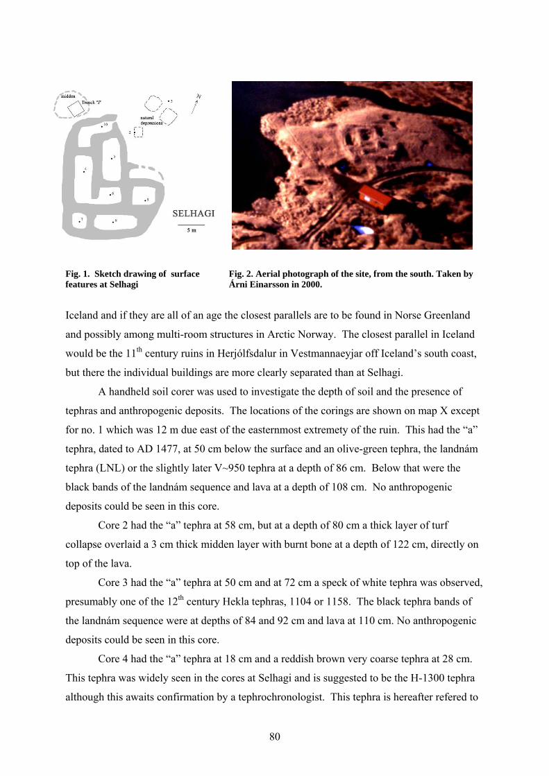
80
Fig. 1. Sketch drawing of surface Fig. 2. Aerial photograph of the site, from the south. Taken by features at Selhagi Árni Einarsson in 2000.
Iceland and if they are all of an age the closest parallels are to be found in Norse Greenland
and possibly among multi-room structures in Arctic Norway. The closest parallel in Iceland
would be the 11th century ruins in Herjólfsdalur in Vestmannaeyjar off Iceland’s south coast,
but there the individual buildings are more clearly separated than at Selhagi.
A handheld soil corer was used to investigate the depth of soil and the presence of
tephras and anthropogenic deposits. The locations of the corings are shown on map X except
for no. 1 which was 12 m due east of the easternmost extremety of the ruin. This had the “a”
tephra, dated to AD 1477, at 50 cm below the surface and an olive-green tephra, the landnám
tephra (LNL) or the slightly later V~950 tephra at a depth of 86 cm. Below that were the
black bands of the landnám sequence and lava at a depth of 108 cm. No anthropogenic
deposits could be seen in this core.
Core 2 had the “a” tephra at 58 cm, but at a depth of 80 cm a thick layer of turf
collapse overlaid a 3 cm thick midden layer with burnt bone at a depth of 122 cm, directly on
top of the lava.
Core 3 had the “a” tephra at 50 cm and at 72 cm a speck of white tephra was observed,
presumably one of the 12th century Hekla tephras, 1104 or 1158. The black tephra bands of
the landnám sequence were at depths of 84 and 92 cm and lava at 110 cm. No anthropogenic
deposits could be seen in this core.
Core 4 had the “a” tephra at 18 cm and a reddish brown very coarse tephra at 28 cm.
This tephra was widely seen in the cores at Selhagi and is suggested to be the H-1300 tephra
although this awaits confirmation by a tephrochronologist. This tephra is hereafter refered to
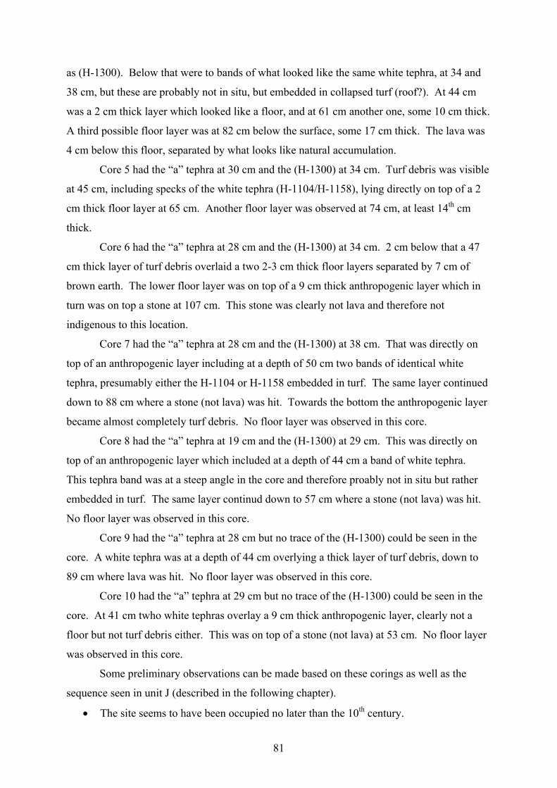
81
as (H-1300). Below that were to bands of what looked like the same white tephra, at 34 and
38 cm, but these are probably not in situ, but embedded in collapsed turf (roof?). At 44 cm
was a 2 cm thick layer which looked like a floor, and at 61 cm another one, some 10 cm thick.
A third possible floor layer was at 82 cm below the surface, some 17 cm thick. The lava was
4 cm below this floor, separated by what looks like natural accumulation.
Core 5 had the “a” tephra at 30 cm and the (H-1300) at 34 cm. Turf debris was visible
at 45 cm, including specks of the white tephra (H-1104/H-1158), lying directly on top of a 2
cm thick floor layer at 65 cm. Another floor layer was observed at 74 cm, at least 14th cm
thick.
Core 6 had the “a” tephra at 28 cm and the (H-1300) at 34 cm. 2 cm below that a 47
cm thick layer of turf debris overlaid a two 2-3 cm thick floor layers separated by 7 cm of
brown earth. The lower floor layer was on top of a 9 cm thick anthropogenic layer which in
turn was on top a stone at 107 cm. This stone was clearly not lava and therefore not
indigenous to this location.
Core 7 had the “a” tephra at 28 cm and the (H-1300) at 38 cm. That was directly on
top of an anthropogenic layer including at a depth of 50 cm two bands of identical white
tephra, presumably either the H-1104 or H-1158 embedded in turf. The same layer continued
down to 88 cm where a stone (not lava) was hit. Towards the bottom the anthropogenic layer
became almost completely turf debris. No floor layer was observed in this core.
Core 8 had the “a” tephra at 19 cm and the (H-1300) at 29 cm. This was directly on
top of an anthropogenic layer which included at a depth of 44 cm a band of white tephra.
This tephra band was at a steep angle in the core and therefore proably not in situ but rather
embedded in turf. The same layer continud down to 57 cm where a stone (not lava) was hit.
No floor layer was observed in this core.
Core 9 had the “a” tephra at 28 cm but no trace of the (H-1300) could be seen in the
core. A white tephra was at a depth of 44 cm overlying a thick layer of turf debris, down to
89 cm where lava was hit. No floor layer was observed in this core.
Core 10 had the “a” tephra at 29 cm but no trace of the (H-1300) could be seen in the
core. At 41 cm twho white tephras overlay a 9 cm thick anthropogenic layer, clearly not a
floor but not turf debris either. This was on top of a stone (not lava) at 53 cm. No floor layer
was observed in this core.
Some preliminary observations can be made based on these corings as well as the
sequence seen in unit J (described in the following chapter).
• The site seems to have been occupied no later than the 10th century.
82
• There is clearly building activity there after H-1104/H-1158 and this had only just
ceased by the time of the deposition of (H-1300) and certainly long before the
deposition of the “a” tephra dated to AD 1477.
• Rooms 4-6 seem to have the longest/most complex history of use and probably
represent the actual dwelling.
• Rooms 7, 8 and 10 are probably paved and may represent animal shelters or storage
rooms.
• Room 9 did not have any surface layer and may therefore be interpreted as a barn or
storage area for hay, peat or other expendibles.
• Some midden formation has taken place immediately east of the structure – in front of
the entrance still visible on the gable of room 10 – but the principal midden is by the
northwestern corner of the structure.
Results
The site of Selhagi appears to have been occupied from the 10th century to the end of the 13th.
It seems to have been – at least initially – used as a year-round dwelling and should be
considered as a farmstead. It is nvertheless possible that the function was changed to a
sheiling sometime in the aforementioned period.
Many questions remain unanswered about this site – questions that can only be
answered by a large scale excavation.
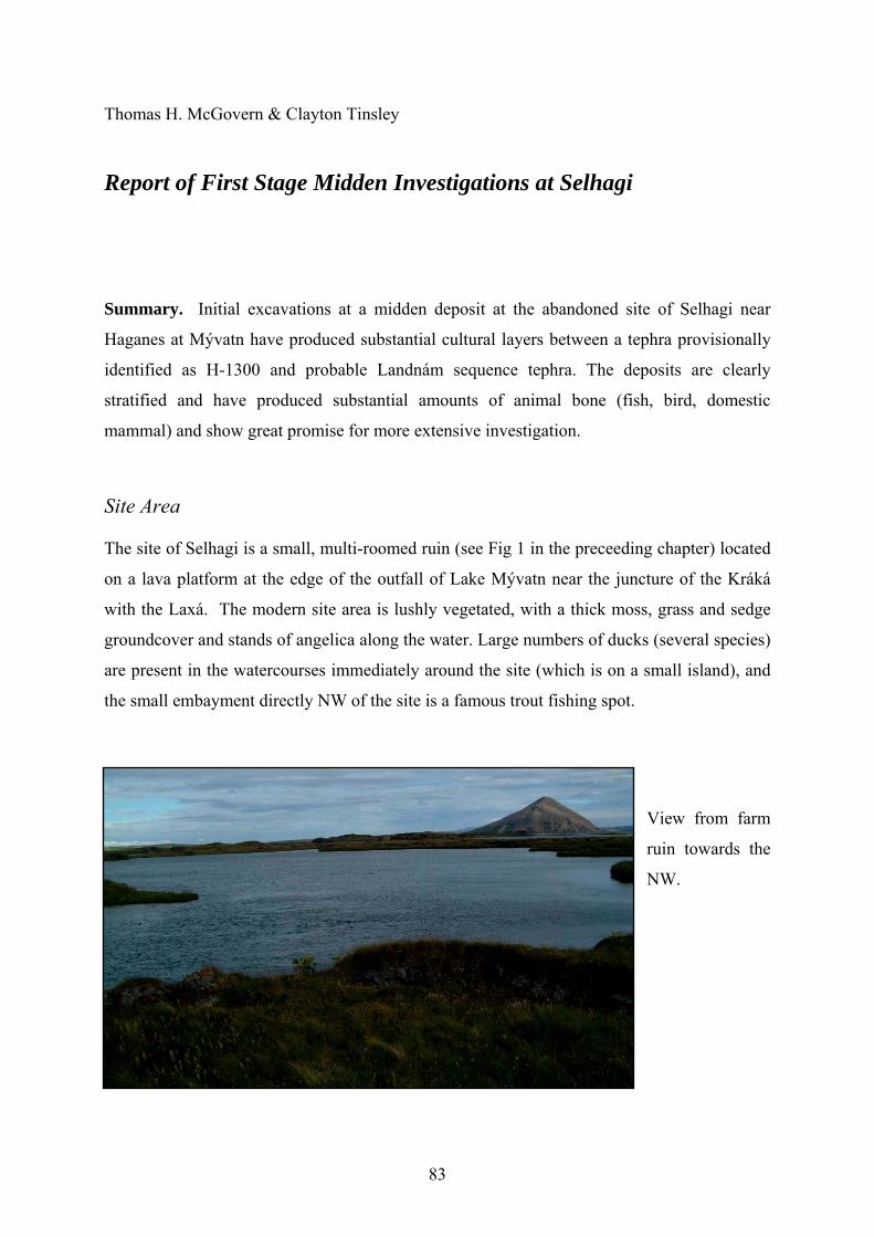
83
Thomas H. McGovern & Clayton Tinsley
Report of First Stage Midden Investigations at Selhagi
Summary. Initial excavations at a midden deposit at the abandoned site of Selhagi near
Haganes at Mývatn have produced substantial cultural layers between a tephra provisionally
identified as H-1300 and probable Landnám sequence tephra. The deposits are clearly
stratified and have produced substantial amounts of animal bone (fish, bird, domestic
mammal) and show great promise for more extensive investigation.
Site Area
The site of Selhagi is a small, multi-roomed ruin (see Fig 1 in the preceeding chapter) located
on a lava platform at the edge of the outfall of Lake Mývatn near the juncture of the Kráká
with the Laxá. The modern site area is lushly vegetated, with a thick moss, grass and sedge
groundcover and stands of angelica along the water. Large numbers of ducks (several species)
are present in the watercourses immediately around the site (which is on a small island), and
the small embayment directly NW of the site is a famous trout fishing spot.
View from farm
ruin towards the
NW.
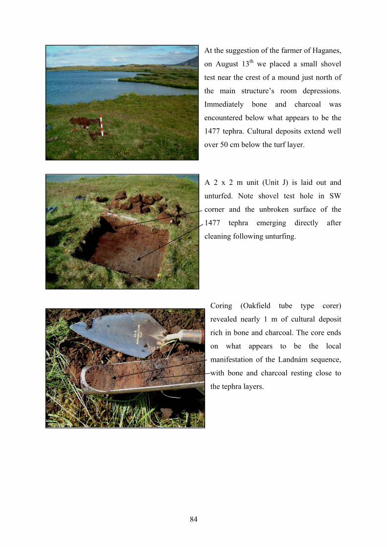
84
At the suggestion of the farmer of Haganes,
on August 13th we placed a small shovel
test near the crest of a mound just north of
the main structure’s room depressions.
Immediately bone and charcoal was
encountered below what appears to be the
1477 tephra. Cultural deposits extend well
over 50 cm below the turf layer.
A 2 x 2 m unit (Unit J) is laid out and
unturfed. Note shovel test hole in SW
corner and the unbroken surface of the
1477 tephra emerging directly after
cleaning following unturfing.
Coring (Oakfield tube type corer)
revealed nearly 1 m of cultural deposit
rich in bone and charcoal. The core ends
on what appears to be the local
manifestation of the Landnám sequence,
with bone and charcoal resting close to
the tephra layers.
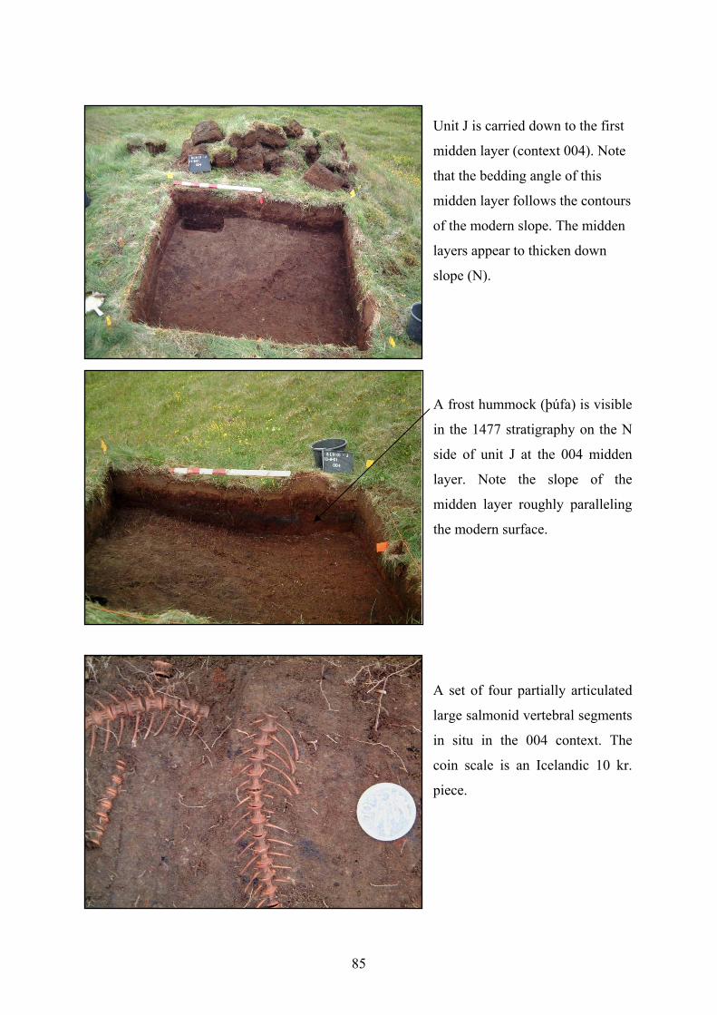
85
Unit J is carried down to the first
midden layer (context 004). Note
that the bedding angle of this
midden layer follows the contours
of the modern slope. The midden
layers appear to thicken down
slope (N).
A frost hummock (þúfa) is visible
in the 1477 stratigraphy on the N
side of unit J at the 004 midden
layer. Note the slope of the
midden layer roughly paralleling
the modern surface.
A set of four partially articulated
large salmonid vertebral segments
in situ in the 004 context. The
coin scale is an Icelandic 10 kr.
piece.
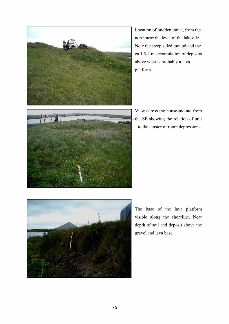
86
Location of midden unit J, from the
north near the level of the lakeside.
Note the steep sided mound and the
ca 1.5-2 m accumulation of deposits
above what is probably a lava
platform.
View across the house-mound from
the SE showing the relation of unit
J to the cluster of room depressions.
The base of the lava platform
visible along the shoreline. Note
depth of soil and deposit above the
gravel and lava base.
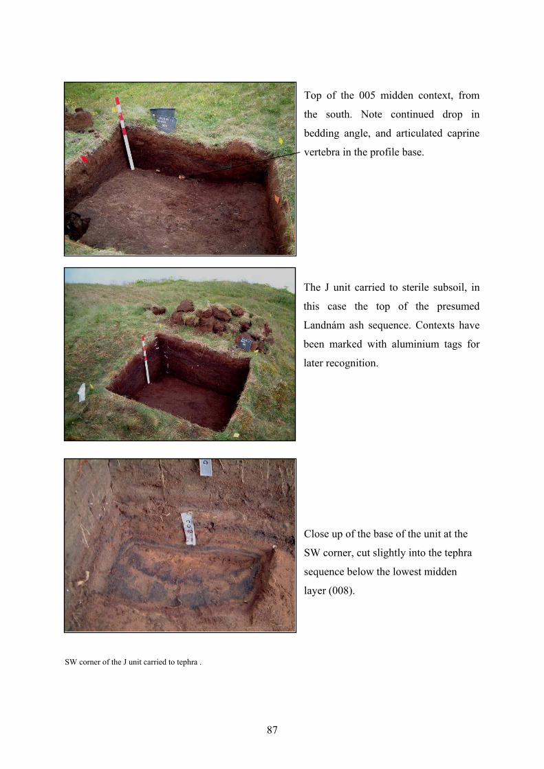
87
Top of the 005 midden context, from
the south. Note continued drop in
bedding angle, and articulated caprine
vertebra in the profile base.
The J unit carried to sterile subsoil, in
this case the top of the presumed
Landnám ash sequence. Contexts have
been marked with aluminium tags for
later recognition.
Close up of the base of the unit at the
SW corner, cut slightly into the tephra
sequence below the lowest midden
layer (008).
SW corner of the J unit carried to tephra .
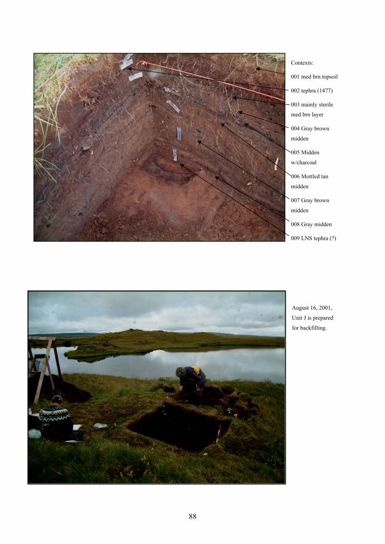
88
Contexts:
001 med brn topsoil
002 tephra (1477)
003 mainly sterile
med brn layer
004 Gray brown
midden
005 Midden
w/charcoal
006 Mottled tan
midden
007 Gray brown
midden
008 Gray midden
009 LNS tephra (?)
August 16, 2001,
Unit J is prepared
for backfilling.
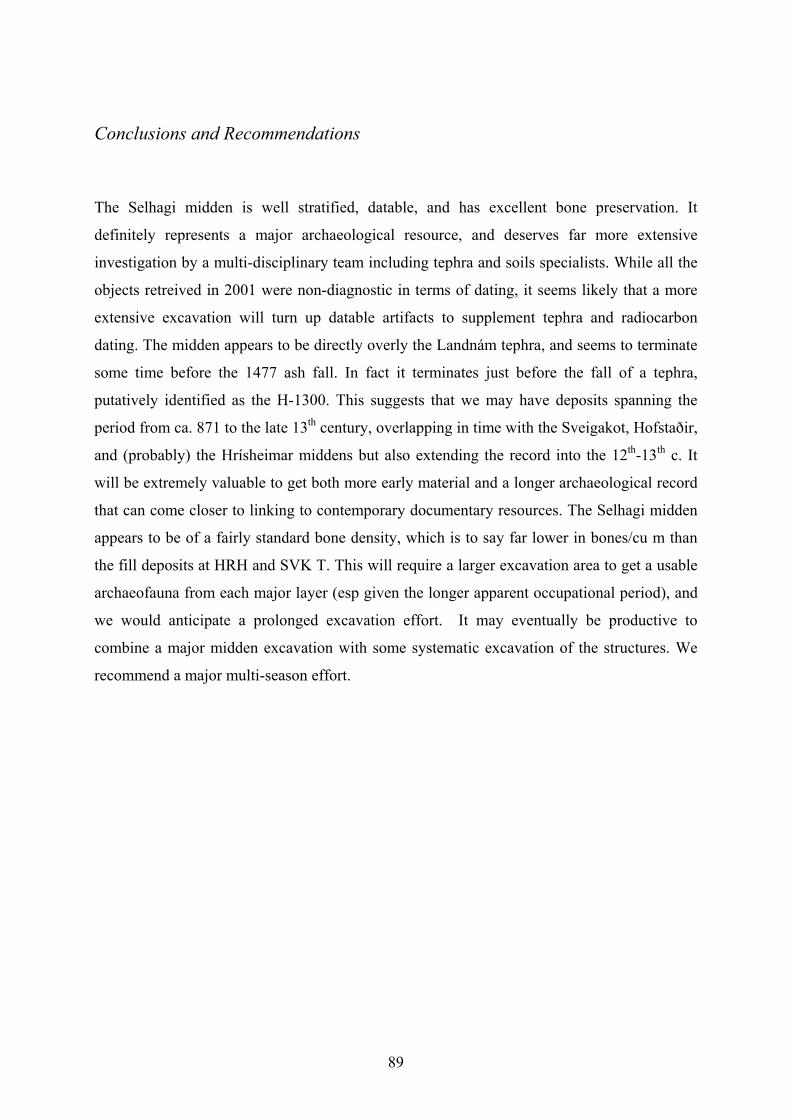
89
Conclusions and Recommendations
The Selhagi midden is well stratified, datable, and has excellent bone preservation. It
definitely represents a major archaeological resource, and deserves far more extensive
investigation by a multi-disciplinary team including tephra and soils specialists. While all the
objects retreived in 2001 were non-diagnostic in terms of dating, it seems likely that a more
extensive excavation will turn up datable artifacts to supplement tephra and radiocarbon
dating. The midden appears to be directly overly the Landnám tephra, and seems to terminate
some time before the 1477 ash fall. In fact it terminates just before the fall of a tephra,
putatively identified as the H-1300. This suggests that we may have deposits spanning the
period from ca. 871 to the late 13th century, overlapping in time with the Sveigakot, Hofstaðir,
and (probably) the Hrísheimar middens but also extending the record into the 12th-13th c. It
will be extremely valuable to get both more early material and a longer archaeological record
that can come closer to linking to contemporary documentary resources. The Selhagi midden
appears to be of a fairly standard bone density, which is to say far lower in bones/cu m than
the fill deposits at HRH and SVK T. This will require a larger excavation area to get a usable
archaeofauna from each major layer (esp given the longer apparent occupational period), and
we would anticipate a prolonged excavation effort. It may eventually be productive to
combine a major midden excavation with some systematic excavation of the structures. We
recommend a major multi-season effort.
90
Thomas H. McGovern & Sophia Perdikaris
Preliminary Report of Animal Bones from Selhagi
Abstract In 2001 the FSĺ / NABO project Landscapes of Settlement in Northern Iceland collected animal bones from a stratified midden deposit associated with the abandoned site Selhagi on the property of the modern farm Haganes. Selhagi is located in the lushly vegetated lakeshore zone and its environmental setting presents a strong contrast with the eroded uplands to the S of the lake where the early sites at Sveigakot and Hrísheimur are under excavation. Close to both major migratory waterfowl nesting areas and some of the best trout fishing in Iceland, the site would appear to be optimally located for exploitation of wild species. The Selhagi site had produced well preserved animal bone during small scale avocational excavations in the 1970’s and the major objective of the 2001 FSĺ /NABO investigations was to map the site and locate possible midden deposits for further work. The fully turf covered site appears to be a small multi-roomed structure with clearly defined room depressions and an apparent mound of midden material to the NW of the structure complex. Coring within the structure indicated that it was abandoned some time before the widespread AD 1477 ash fall and show the presence of the 1104 and 1158 tephras as well. The midden team carried out a small-scale (2 x 2 m) stratigraphic test excavation which found well preserved animal bone in clearly stratified midden deposits that were definitely capped by the AD 1477 ash fall and probably also by a thinner 1300 tephra. At base, the midden deposits directly overly the local variant of the “Landnám” tephra of c. AD 871. While radiocarbon dates are pending, it would appear that Selhagi has a long occupational history extending from settlement times perhaps until the later 13th century. A preliminary analysis of the animal bones recovered indicate the normal range of domesticates (cattle, sheep, goat, pig), substantial amounts of freshwater fish (trout and charr), and a few migratory birds (duck and swan) as well as bird egg shell. More surprising is the presence of marine fish (cod family) and sea birds (Guillemot/Murre and Razorbill). Despite the lakeshore setting, the Selhagi archaeofauna thus far does not indicate any intensive exploitation of adult migratory waterfowl. This small initial sample does indicate that the site participated in a social and economic network that provided regular access to distant marine resources. While larger samples are needed to better understand possible trends through time, the present sample shows an apparent reduction in cattle relative to caprines (sheep & goat) from lower layers to upper that parallels a general reduction in domesticates relative to wild species. Further investigations at this promising site are needed to better document these apparent trends and better understand the economic changes at Selhagi during its period of occupation. Selhagi Excavations 2001
The site of Selhagi is a small, multi-roomed ruin located on a lava platform at the edge of the
outfall of Lake Mývatn near the juncture of the Kraká with the Laxá drainage. The modern
site area is lushly vegetated, with a thick moss, grass, and sedge groundcover and stands of
angelica along the water. Large numbers of ducks (several species) are present in the
watercourses immediately around the site (which is on a small island), and the small
embayment directly NW of the site is a famous trout fishing spot. On the advice of the farmer
of Haganes we shovel tested a small mound to the NW of the cluster of room depressions
visible on the surface. Immediately we encountered the 1477 tephra below the modern turf
(context 001), and below that a concentration of well preserved bones. We set up a 2x2 m unit
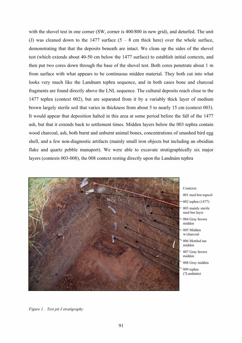
91
with the shovel test in one corner (SW, corner is 400/800 in new grid), and deturfed. The unit
(J) was cleaned down to the 1477 surface (5 – 8 cm thick here) over the whole surface,
demonstrating that that the deposits beneath are intact. We clean up the sides of the shovel
test (which extends about 40-50 cm below the 1477 surface) to establish initial contexts, and
then put two cores down through the base of the shovel test. Both cores penetrate about 1 m
from surface with what appears to be continuous midden material. They both cut into what
looks very much like the Landnam tephra sequence, and in both cases bone and charcoal
fragments are found directly above the LNL sequence. The cultural deposits reach close to the
1477 tephra (context 002), but are separated from it by a variably thick layer of medium
brown largely sterile soil that varies in thickness from about 5 to nearly 15 cm (context 003).
It would appear that deposition halted in this area at some period before the fall of the 1477
ash, but that it extends back to settlement times. Midden layers below the 003 tephra contain
wood charcoal, ash, both burnt and unburnt animal bones, concentrations of smashed bird egg
shell, and a few non-diagnostic artifacts (mainly small iron objects but including an obsidian
flake and quartz pebble manuport). We were able to excavate stratigraphically six major
layers (contexts 003-008), the 008 context resting directly upon the Landnám tephra
Contexts:
001 med brn topsoil
002 tephra (1477)
003 mainly sterile med brn layer
004 Gray brown midden
005 Midden w/charcoal
006 Mottled tan midden
007 Gray brown midden
008 Gray midden
009 tephra (?Landnám)
Figure 1 . Test pit J stratigraphy
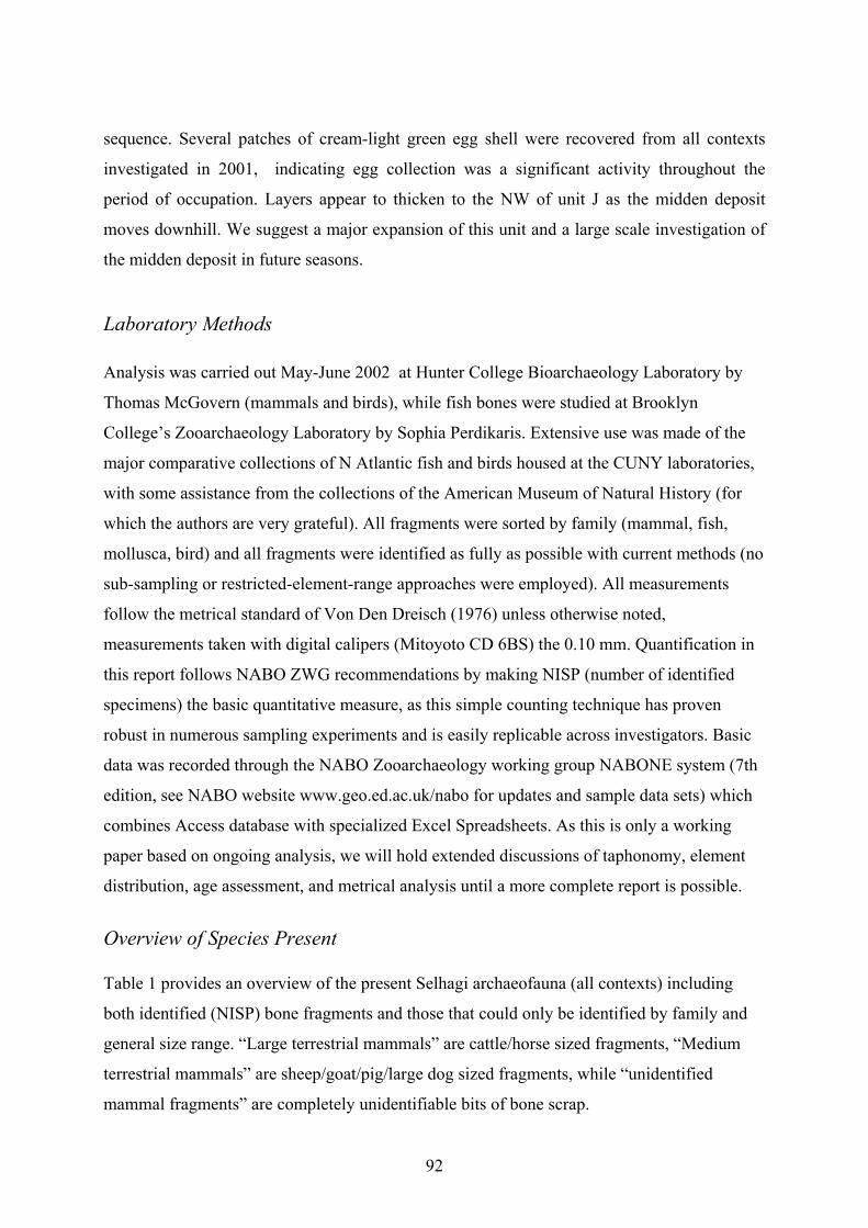
92
sequence. Several patches of cream-light green egg shell were recovered from all contexts
investigated in 2001, indicating egg collection was a significant activity throughout the
period of occupation. Layers appear to thicken to the NW of unit J as the midden deposit
moves downhill. We suggest a major expansion of this unit and a large scale investigation of
the midden deposit in future seasons.
Laboratory Methods Analysis was carried out May-June 2002 at Hunter College Bioarchaeology Laboratory by
Thomas McGovern (mammals and birds), while fish bones were studied at Brooklyn
College’s Zooarchaeology Laboratory by Sophia Perdikaris. Extensive use was made of the
major comparative collections of N Atlantic fish and birds housed at the CUNY laboratories,
with some assistance from the collections of the American Museum of Natural History (for
which the authors are very grateful). All fragments were sorted by family (mammal, fish,
mollusca, bird) and all fragments were identified as fully as possible with current methods (no
sub-sampling or restricted-element-range approaches were employed). All measurements
follow the metrical standard of Von Den Dreisch (1976) unless otherwise noted,
measurements taken with digital calipers (Mitoyoto CD 6BS) the 0.10 mm. Quantification in
this report follows NABO ZWG recommendations by making NISP (number of identified
specimens) the basic quantitative measure, as this simple counting technique has proven
robust in numerous sampling experiments and is easily replicable across investigators. Basic
data was recorded through the NABO Zooarchaeology working group NABONE system (7th
edition, see NABO website www.geo.ed.ac.uk/nabo for updates and sample data sets) which
combines Access database with specialized Excel Spreadsheets. As this is only a working
paper based on ongoing analysis, we will hold extended discussions of taphonomy, element
distribution, age assessment, and metrical analysis until a more complete report is possible.
Overview of Species Present Table 1 provides an overview of the present Selhagi archaeofauna (all contexts) including
both identified (NISP) bone fragments and those that could only be identified by family and
general size range. “Large terrestrial mammals” are cattle/horse sized fragments, “Medium
terrestrial mammals” are sheep/goat/pig/large dog sized fragments, while “unidentified
mammal fragments” are completely unidentifiable bits of bone scrap.
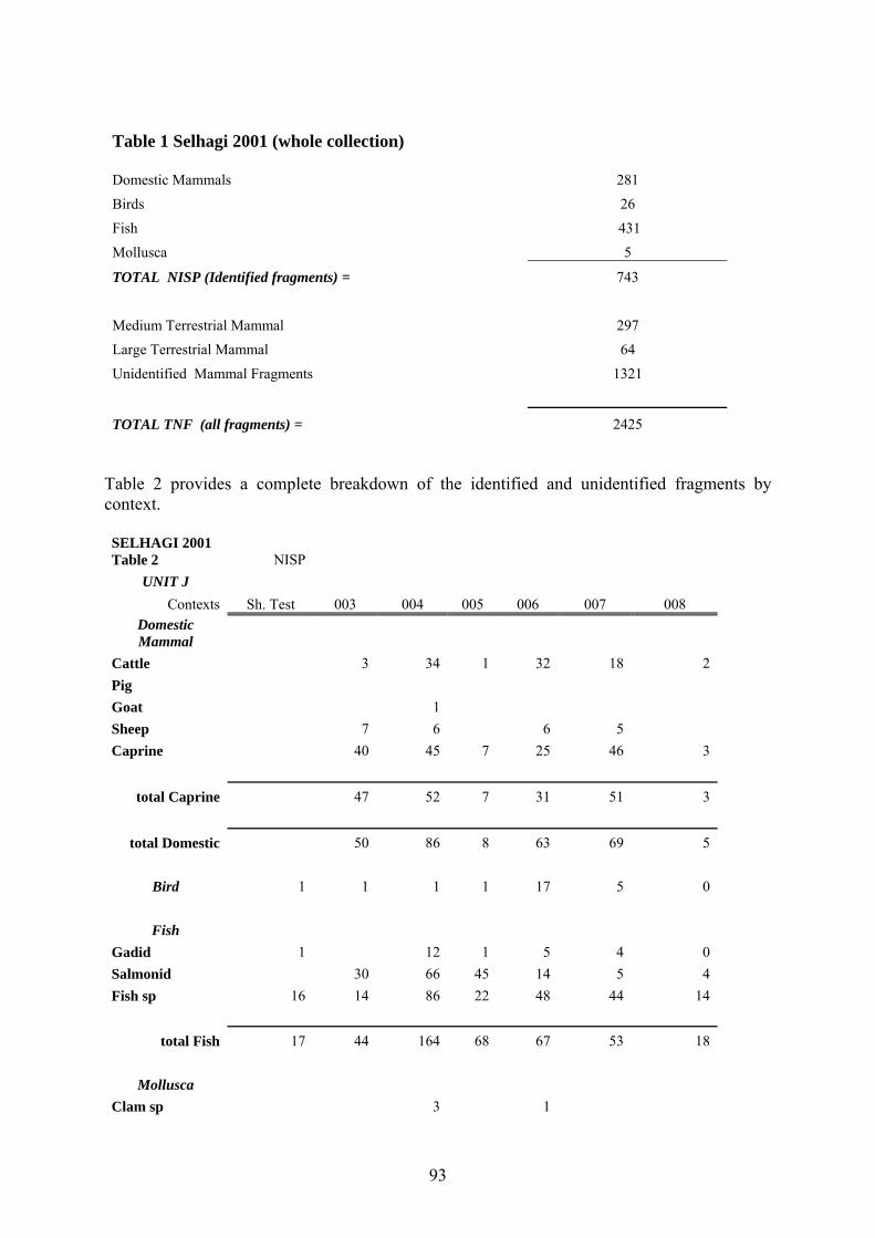
93
Table 1 Selhagi 2001 (whole collection) Domestic Mammals 281
Birds 26 Fish 431
Mollusca 5
TOTAL NISP (Identified fragments) = 743
Medium Terrestrial Mammal 297 Large Terrestrial Mammal 64
Unidentified Mammal Fragments 1321
TOTAL TNF (all fragments) = 2425 Table 2 provides a complete breakdown of the identified and unidentified fragments by context. SELHAGI 2001 Table 2 NISP
UNIT J Contexts Sh. Test 003 004 005 006 007 008
Domestic Mammal
Cattle 3 34 1 32 18 2 Pig Goat 1 Sheep 7 6 6 5 Caprine 40 45 7 25 46 3
total Caprine 47 52 7 31 51 3
total Domestic 50 86 8 63 69 5
Bird 1 1 1 1 17 5 0
Fish Gadid 1 12 1 5 4 0 Salmonid 30 66 45 14 5 4 Fish sp 16 14 86 22 48 44 14
total Fish 17 44 164 68 67 53 18
Mollusca Clam sp 3 1
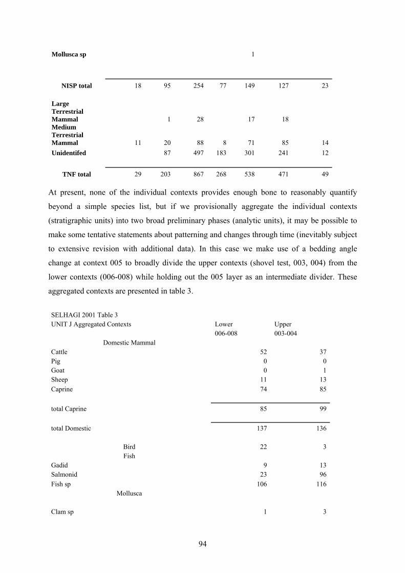
94
Mollusca sp 1
NISP total 18 95 254 77 149 127 23
Large Terrestrial Mammal 1 28 17 18 Medium Terrestrial Mammal 11 20 88 8 71 85 14 Unidentifed 87 497 183 301 241 12
TNF total 29 203 867 268 538 471 49 At present, none of the individual contexts provides enough bone to reasonably quantify
beyond a simple species list, but if we provisionally aggregate the individual contexts
(stratigraphic units) into two broad preliminary phases (analytic units), it may be possible to
make some tentative statements about patterning and changes through time (inevitably subject
to extensive revision with additional data). In this case we make use of a bedding angle
change at context 005 to broadly divide the upper contexts (shovel test, 003, 004) from the
lower contexts (006-008) while holding out the 005 layer as an intermediate divider. These
aggregated contexts are presented in table 3.
SELHAGI 2001 Table 3 UNIT J Aggregated Contexts Lower Upper 006-008 003-004
Domestic Mammal Cattle 52 37 Pig 0 0 Goat 0 1 Sheep 11 13 Caprine 74 85 total Caprine 85 99 total Domestic 137 136
Bird 22 3 Fish
Gadid 9 13 Salmonid 23 96 Fish sp 106 116
Mollusca
Clam sp 1 3
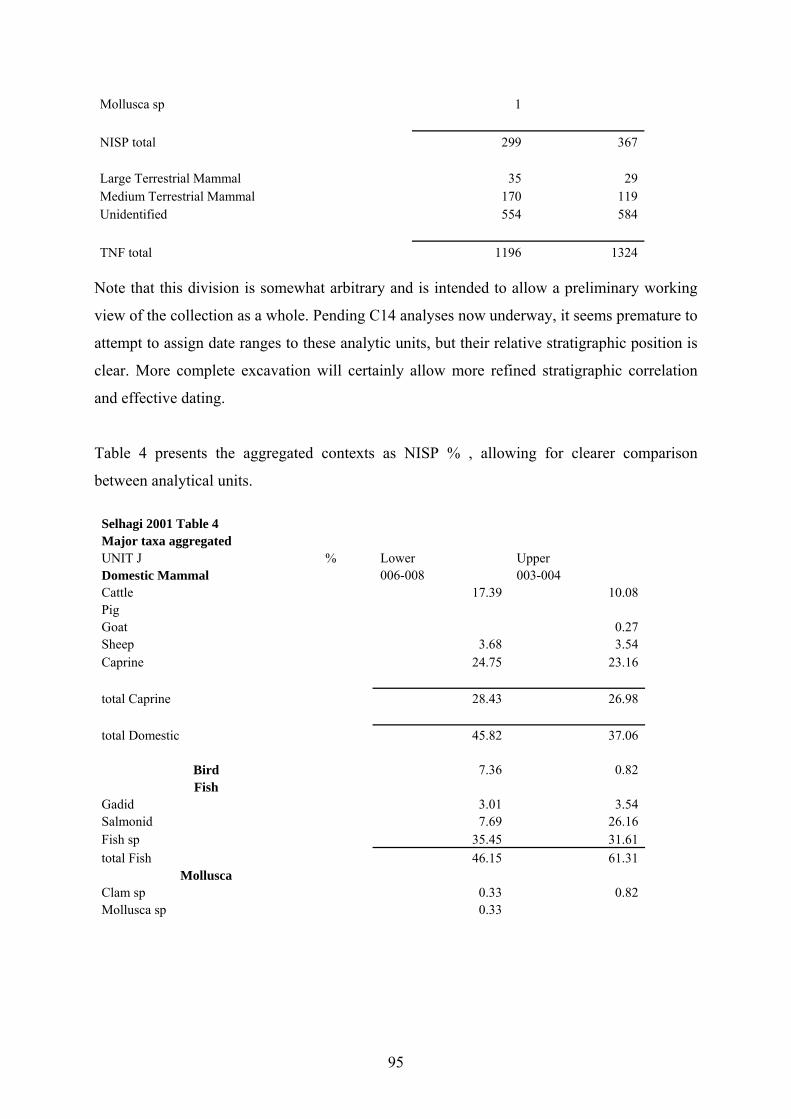
95
Mollusca sp 1 NISP total 299 367 Large Terrestrial Mammal 35 29 Medium Terrestrial Mammal 170 119 Unidentified 554 584 TNF total 1196 1324
Note that this division is somewhat arbitrary and is intended to allow a preliminary working
view of the collection as a whole. Pending C14 analyses now underway, it seems premature to
attempt to assign date ranges to these analytic units, but their relative stratigraphic position is
clear. More complete excavation will certainly allow more refined stratigraphic correlation
and effective dating.
Table 4 presents the aggregated contexts as NISP % , allowing for clearer comparison
between analytical units.
Selhagi 2001 Table 4 Major taxa aggregated UNIT J % Lower Upper Domestic Mammal 006-008 003-004 Cattle 17.39 10.08 Pig Goat 0.27 Sheep 3.68 3.54 Caprine 24.75 23.16 total Caprine 28.43 26.98 total Domestic 45.82 37.06
Bird 7.36 0.82 Fish
Gadid 3.01 3.54 Salmonid 7.69 26.16 Fish sp 35.45 31.61 total Fish 46.15 61.31
Mollusca Clam sp 0.33 0.82 Mollusca sp 0.33
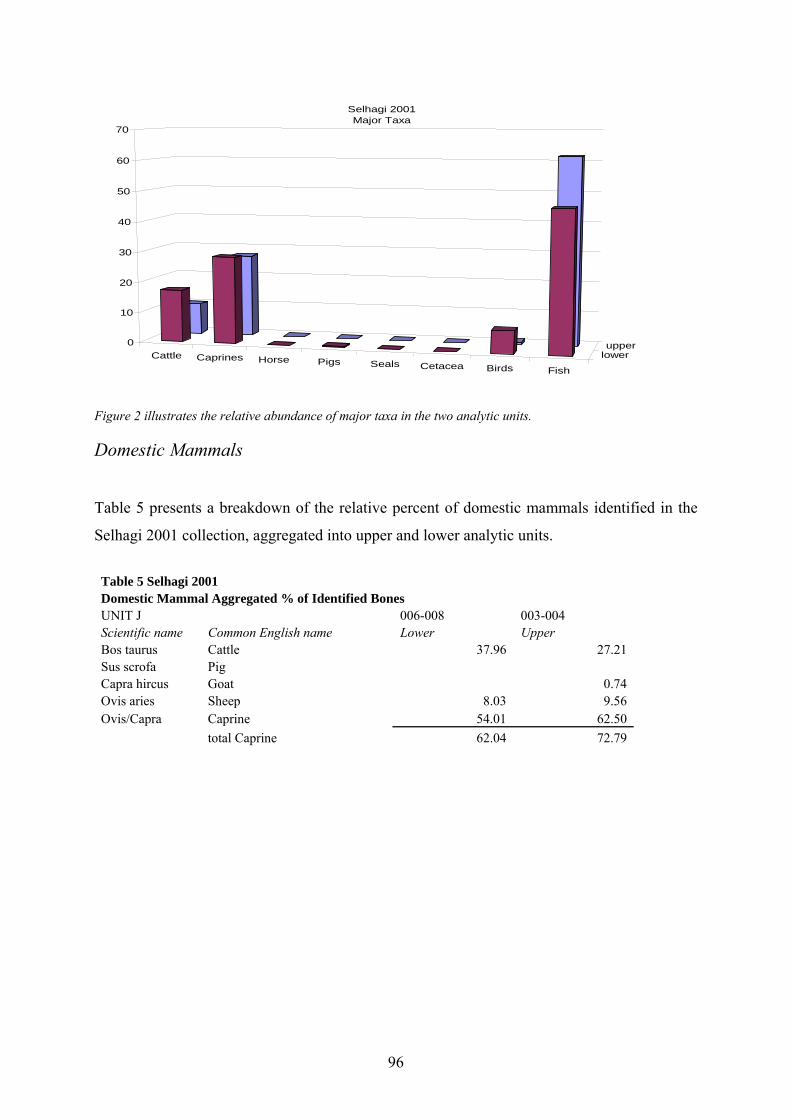
96
Cattle Caprines Horse Pigs Seals Cetacea Birds Fish
lowerupper0
10
20
30
40
50
60
70
Selhagi 2001 Major Taxa
Figure 2 illustrates the relative abundance of major taxa in the two analytic units. Domestic Mammals
Table 5 presents a breakdown of the relative percent of domestic mammals identified in the
Selhagi 2001 collection, aggregated into upper and lower analytic units.
Table 5 Selhagi 2001 Domestic Mammal Aggregated % of Identified Bones UNIT J 006-008 003-004 Scientific name Common English name Lower Upper Bos taurus Cattle 37.96 27.21 Sus scrofa Pig Capra hircus Goat 0.74 Ovis aries Sheep 8.03 9.56 Ovis/Capra Caprine 54.01 62.50 total Caprine 62.04 72.79
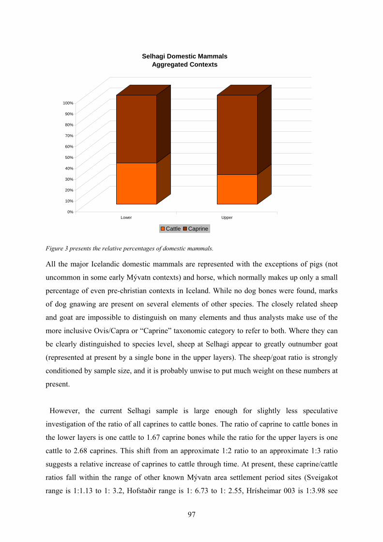
97
0%
10%
20%
30%
40%
50%
60%
70%
80%
90%
100%
Lower Upper
Selhagi Domestic Mammals Aggregated Contexts
Cattle Caprine Figure 3 presents the relative percentages of domestic mammals. All the major Icelandic domestic mammals are represented with the exceptions of pigs (not
uncommon in some early Mývatn contexts) and horse, which normally makes up only a small
percentage of even pre-christian contexts in Iceland. While no dog bones were found, marks
of dog gnawing are present on several elements of other species. The closely related sheep
and goat are impossible to distinguish on many elements and thus analysts make use of the
more inclusive Ovis/Capra or “Caprine” taxonomic category to refer to both. Where they can
be clearly distinguished to species level, sheep at Selhagi appear to greatly outnumber goat
(represented at present by a single bone in the upper layers). The sheep/goat ratio is strongly
conditioned by sample size, and it is probably unwise to put much weight on these numbers at
present.
However, the current Selhagi sample is large enough for slightly less speculative
investigation of the ratio of all caprines to cattle bones. The ratio of caprine to cattle bones in
the lower layers is one cattle to 1.67 caprine bones while the ratio for the upper layers is one
cattle to 2.68 caprines. This shift from an approximate 1:2 ratio to an approximate 1:3 ratio
suggests a relative increase of caprines to cattle through time. At present, these caprine/cattle
ratios fall within the range of other known Mývatn area settlement period sites (Sveigakot
range is 1:1.13 to 1: 3.2, Hofstaðir range is 1: 6.73 to 1: 2.55, Hrísheimar 003 is 1:3.98 see
98
Tinsley 2000,2001, McGovern & Perdikaris 2002). Our usual assumption is that a high ratio
of cattle to caprines tends to be associated with a combination of higher status and access to
higher quality pasture, and it is possible that these ratios (based on modest sample sizes)
reflect better access to wet meadow grazing, but again larger samples will be needed to go
further.
Butchery Marks Table 6 presents the distribution of butchery marks on the domestic mammal bones. As at
Hofstaðir, Hrísheimur, and Sveigakot, many heavy chopping marks left by axes or heavy
cleavers were evident, probably mainly reflecting primary dismemberment of the animal
carcasses. Splitting longitudinally was the dominant method of bone marrow extraction, and
the later (post ca 1100) Icelandic practice of biperforation of the caprine metapodial was not
seen in the collection. Chopping marks in the Selhagi collection are mainly on horn cores,
while splitting was applied widely to long bones. At present there is no clear indication of
change through time in patterns of butchery at Selhagi.
Table 6 Butchery Marks
Species Chopping split
Cattle 3 5
Goat 1
Sheep 3 3
Caprine 2 22 Age at Death Standard measures of the age of death of domestic mammals (used to reconstruct herding
strategy) include the fusion of long bones (epiphyseal fusion), eruption and wear of teeth, and
the presence of newborn (late fetal or neonatal) animal bones. All of these approaches are
strongly subject to sample size and a full analysis is thus best left until a more complete
excavation has been carried out, but a few observations may be noted here. Table 7 presents
the fetal (newborn) and neonatal (less than 3 months) bones recovered from the, both as
counts and as percentages of their respective species.
99
Table 7 Mammal Age Selhagi 2001
NISP Fetal neonatal adult and older juven. total
Cattle 51 38 89
Caprine 8 158 166 As in most Icelandic collections, cattle show the highest percentage of neonates, almost
certainly reflecting a dairy economy (see Halstead 1999 for discussion).
Birds
Table 8 presents the breakdown of bird remains from the 2001 Selhagi contexts. In addition to
the bones listed, concentrations of pale blue-pale green egg shells were present in all contexts.
Table 8 SELHAGI 2001 Birds UNIT J NISP upper Intermed. lower
Scientific names Engl.
Common Sh. Test 003 004 005 006 007 008Sea Birds
Uria sp. Murre or Guillemot 1 2
Alca torda Razorbill 1 Non-Migratory Terrestr.
Lagopus mutus Ptarmigan 3 Ducks
Anatidae Duck Sp. ? 1 Swan
Cygnus sp. Swan Sp. ? 4 Aves sp. Bird sp. ? 1 1 12 total 1 1 1 1 17 5 0
Despite their limited numbers the Selhagi bird remains present several surprises, particularly
given the lakeshore location of the site:
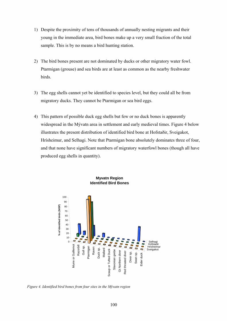
100
1) Despite the proximity of tens of thousands of annually nesting migrants and their
young in the immediate area, bird bones make up a very small fraction of the total
sample. This is by no means a bird hunting station.
2) The bird bones present are not dominated by ducks or other migratory water fowl.
Ptarmigan (grouse) and sea birds are at least as common as the nearby freshwater
birds.
3) The egg shells cannot yet be identified to species level, but they could all be from
migratory ducks. They cannot be Ptarmigan or sea bird eggs.
4) This pattern of possible duck egg shells but few or no duck bones is apparently
widespread in the Mývatn area in settlement and early medieval times. Figure 4 below
illustrates the present distribution of identified bird bone at Hofstaðir, Sveigakot,
Hrísheimur, and Selhagi. Note that Ptarmigan bone absolutely dominates three of four,
and that none have significant numbers of migratory waterfowl bones (though all have
produced egg shells in quantity).
Mur
re o
r Gui
llem
ot
Raz
orbi
ll
Gul
l sp.
Ptar
mig
an
Rav
en
Duc
k sp
.
Mal
lard
Sca
up o
r Tuf
ted
Duc
k
Sla
voni
an g
rebe
Gt N
orth
ern
dive
r
Red
thro
ated
div
er
Div
er s
p.
Sw
an s
p.
Eide
r duc
k
SveigakotHrísheimarHofstadirSelhagi0
10
20
30
40
50
60
70
80
90
100
% o
f ide
ntifi
ed b
irds
(NIS
P)
Myvatn Region Identified Bird Bones
Figure 4. Identified bird bones from four sites in the Mývatn region
101
We suggest that this pattern is strongly suggestive of a sustained yield exploitation of eggs
combined with some sort of social prohibition on taking nesting adults. The current pattern of
local level bird conservation in the Mývatn region thus appears to have deep historical roots.
This pattern raises interesting questions about the social organization of landscape and
allocation of rights to “natural capital” in the Settlement Period and early Middle Ages,
especially in light of the very different long term outcome of pasture management strategies.
Fish
At present, we can make some observations on fishing at Selhagi:
1) As at the other early Mývatn area sites, Salmonid family (trout and charr) are the most
common fish.
2) Some trout from Selhagi are very large, and several articulated trout vertebral
segments (remains of filleting?) were identified in situ.
3) However, marine fish are also present at Selhagi in some numbers. These include
haddock and cod, and the elements present strongly suggest the import of cured fish
rather than whole animals (as at other Mývatn sites).
4) Selhagi’s optimum location for fresh water fishing was certainly not ignored by the
Viking age settlers, but the farm nevertheless consumed imported preserved marine
fish in much the same way as the other early sites documented (Hofstaðir, Sveigakot,
Hrísheimur). Despite locally available freshwater fish, the people of Selhagi continued
to obtain significant amounts of cured marine fish products through some sort of
social or commercial network.
Directions for Further Research
While the Selhagi archaeofauna is currently too small to support a full analysis and to fully
realize its potential for documenting economic change through time, it has already provided
102
some thought-provoking interpretive challenges. The patterning in fish and bird remains is
particularly intriguing and deserves further investigation. Additional excavations to recover
larger stratified bone collections are certainly warranted.
Acknowledgements:
The authors would like to gratefully acknowledge the sustained support of the NABO
research cooperative and the generosity of its members in promoting international,
interdisciplinary research projects and for providing stimulating discussion and interaction
over the past decade. Results reported here are the product of sustained support from the US
National Science Foundation (Office of Polar Programs Arctic Social Science Program,
Research Experience for Undergraduates Program, and Anthropology Program), the Icelandic
Science Council, National Geographic Society, PSC-CUNY Grants Program, and the
Archaeological Institute Iceland.
103
Natascha Mehler
Selhagi 2001 - the finds. Preliminary Report
Introduction
Eight artefaacts were retreived during the archaeological excavation at Selhagi in August
2001. All the finds were numbered in a field finds list, and after cleaning registered in the
excavation database. Where appropriate, conservation was undertaken by Jannie Ebsen. Six
objects are of metal, now corroded but in average to good condition, two are of indigenous
stone types. As the site was covered by the (H-1300) tephra all thee artefacts date before that
time. None of them shows any typological criteria. Similar stone and metal artefacts are
known from other Icelandic sites and appear in times of the settlement and middle ages. The
most interesting find is SLH 01-002, a small nail made of composite metal.
Stone objects
Two stone artefacts were found. SLH 01-003 is a piece of black worked obsidian. Black
obsidian (hrafntinna) is indigenous to Iceland and occurs for example south of mount Krafla
close to lake Mývatn20, from where it could have been transported. SLH 01-005 is a small
round unworked quartz pebble of whitish to yellowish colour, also indigenous to Iceland.
Neither stone type occurs naturally at the site. Unworked quartz and worked pieces of black
obsidian have also been found at the Viking age sites in Hofstaðir and Reykjavík, Aðalstræti,
where quartz pieces form the largest group of transported stones.21 The purpose of quartz
pebbles found in Viking age and medieval contexts is unknown. They could have been used
as gaming pieces.
20 Kristján Sæmundsson & Einar Gunnlaugsson 1999, 67. 21 Mehler 2001a, 70; Mehler 2001b, 79 and 82.
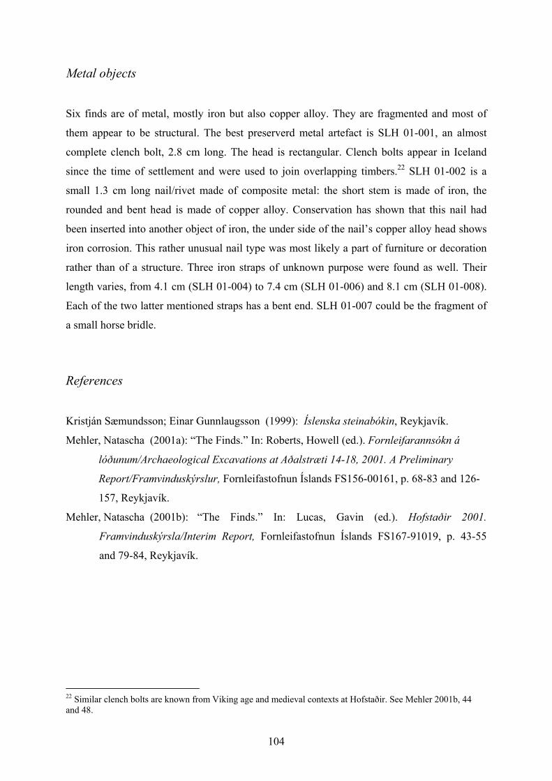
104
Metal objects
Six finds are of metal, mostly iron but also copper alloy. They are fragmented and most of
them appear to be structural. The best preserverd metal artefact is SLH 01-001, an almost
complete clench bolt, 2.8 cm long. The head is rectangular. Clench bolts appear in Iceland
since the time of settlement and were used to join overlapping timbers.22 SLH 01-002 is a
small 1.3 cm long nail/rivet made of composite metal: the short stem is made of iron, the
rounded and bent head is made of copper alloy. Conservation has shown that this nail had
been inserted into another object of iron, the under side of the nail’s copper alloy head shows
iron corrosion. This rather unusual nail type was most likely a part of furniture or decoration
rather than of a structure. Three iron straps of unknown purpose were found as well. Their
length varies, from 4.1 cm (SLH 01-004) to 7.4 cm (SLH 01-006) and 8.1 cm (SLH 01-008).
Each of the two latter mentioned straps has a bent end. SLH 01-007 could be the fragment of
a small horse bridle.
References
Kristján Sæmundsson; Einar Gunnlaugsson (1999): Íslenska steinabókin, Reykjavík.
Mehler, Natascha (2001a): “The Finds.” In: Roberts, Howell (ed.). Fornleifarannsókn á
lóðunum/Archaeological Excavations at Aðalstræti 14-18, 2001. A Preliminary
Report/Framvinduskýrslur, Fornleifastofnun Íslands FS156-00161, p. 68-83 and 126-
157, Reykjavík.
Mehler, Natascha (2001b): “The Finds.” In: Lucas, Gavin (ed.). Hofstaðir 2001.
Framvinduskýrsla/Interim Report, Fornleifastofnun Íslands FS167-91019, p. 43-55
and 79-84, Reykjavík.
22 Similar clench bolts are known from Viking age and medieval contexts at Hofstaðir. See Mehler 2001b, 44 and 48.
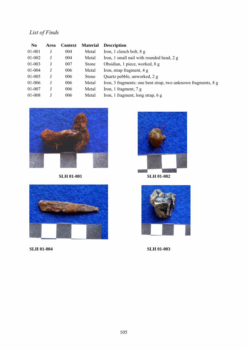
105
List of Finds No Area Context Material Description
01-001 J 004 Metal Iron, 1 clench bolt, 8 g 01-002 J 004 Metal Iron, 1 small nail with rounded head, 2 g 01-003 J 007 Stone Obsidian, 1 piece, worked, 8 g 01-004 J 006 Metal Iron, strap fragment, 4 g 01-005 J 006 Stone Quartz pebble, unworked, 2 g 01-006 J 006 Metal Iron, 3 fragments: one bent strap, two unknown fragments, 8 g 01-007 J 006 Metal Iron, 1 fragment, 7 g 01-008 J 006 Metal Iron, 1 fragment, long strap, 6 g
SLH 01-001 SLH 01-002
SLH 01-004 SLH 01-003
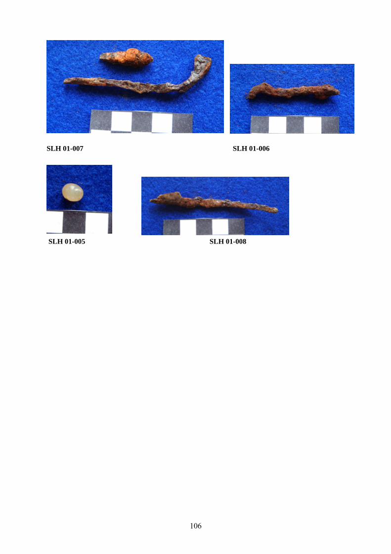
106
SLH 01-007 SLH 01-006
SLH 01-005 SLH 01-008
107
Magnús Á. Sigurgeirsson, Orri Vésteinsson & Hafliði Hafliðason
Gjóskulagarannsóknir við Mývatn - aldursgreining elstu byggðar23
Á undanförnum áratug hafa staðið yfir umfangsmiklar fornleifarannsóknir á Hofstöðum og
Sveigakoti í Mývatnssveit (Adolf Friðriksson og Orri Vésteinsson 1998, Orri Vésteinsson
2001). Við aldursákvörðun rústanna hefur einkum verið stuðst við gjóskulagatímatal og
aldursgreiningar með geislakoli (14C). Gjóskulagatímatalið hefur reynst mjög notadrjúgt þar
sem í jarðvegi á Mývatnssvæðinu er fjöldi gjóskulaga sem fallið hafa eftir að land byggðist
fyrir 1100-1200 árum (Magnús Á. Sigurgeirsson 1998). Næst undir torflögum skálans á
Hofstöðum er gjóskulag sem í gegnum tíðina hefur verið greint sem Landnámslagið. Það er
talið vera frá því um 870 e. Kr (Grönvold o.fl.1995). Nýverið hafa komið fram vísbendingar
um að þetta gjóskulag sé ekki Landnámslagið heldur nokkru yngra lag.
Við rannsóknir á fornbýli í Sveigakoti sumarið 1999 fundust tvö sorplög, mestmegnis
bein og sót, aðskilin af þunnu jarðvegslagi sem inniheldur grágrænt gjóskulag. Ennfremur
kom í ljós að undir neðra sorplaginu var annað gjóskulag með svipað útlit. Sökum
langvarandi jarðvegseyðingar á bæjarstæðinu voru engin yngri gjóskulög varðveitt. Vegna
mikilvægis gjóskulaganna við aldursgreiningu mannvistarlaganna var farið í sérstaka
rannsókn á þessum tveimur lögum. Kom fljótlega í ljós að gjóskulögin voru frá því um
landnám og að annað þessara laga væri að öllum líkindum Landnámslagið. Hins vegar var
ekki ljóst hvort þeirra væri Landnámslagið og því mikilvægt að fá úr því skorið. Greint verður
stuttlega frá niðurstöðum þessara athugana hér.
Byrjað var á að kanna gjóskulög í rofabörðum í nágrenni Sveigakots en á bæjarstæðinu
sjálfu er jarðvegur nánast með öllu eyddur. Gott viðmiðunarsnið fannst undir NV-hlíð
Sellandafjalls, um 10 km sunnan Sveigakots. Gjóskusýni voru tekin til efnagareiningar úr
þessu sniði og auk þess frá Hofstöðum og Sveigakoti. Efnagreiningar á aðalefnum benda til
að upptök gjóskulaganna beggja séu í sama megineldstöðvakerfi, þ.e. Veiðivatna-
Dyngjuhálskerfinu. Lausleg könnun á útbreiðslu efra gjóskulagsins leiðir í ljós að það er
heldur þykkara á Mývatnssvæðinu en neðra lagið. Bráðabirgðakort af útbreiðslu þess hefur
verið gert (mynd 1). Þykkt neðra gjóskulagsins er í betra samræmi við útbreiðslu
Landnámslagsins (Larsen 1984). Litur þess er heldur ljósari en á því efra og líkari lit dökka 23 Þessi grein hefur áður verið birt sem veggspjald á vorráðstefnu Jarðfræðafélags Íslands í Reykjavík 15. apríl 2002.
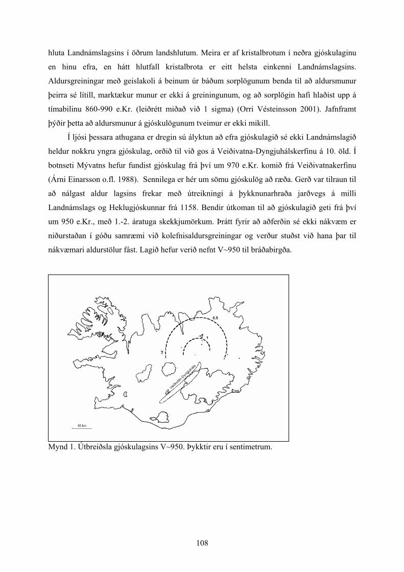
108
hluta Landnámslagsins í öðrum landshlutum. Meira er af kristalbrotum í neðra gjóskulaginu
en hinu efra, en hátt hlutfall kristalbrota er eitt helsta einkenni Landnámslagsins.
Aldursgreiningar með geislakoli á beinum úr báðum sorplögunum benda til að aldursmunur
þeirra sé lítill, marktækur munur er ekki á greiningunum, og að sorplögin hafi hlaðist upp á
tímabilinu 860-990 e.Kr. (leiðrétt miðað við 1 sigma) (Orri Vésteinsson 2001). Jafnframt
þýðir þetta að aldursmunur á gjóskulögunum tveimur er ekki mikill.
Í ljósi þessara athugana er dregin sú ályktun að efra gjóskulagið sé ekki Landnámslagið
heldur nokkru yngra gjóskulag, orðið til við gos á Veiðivatna-Dyngjuhálskerfinu á 10. öld. Í
botnseti Mývatns hefur fundist gjóskulag frá því um 970 e.Kr. komið frá Veiðivatnakerfinu
(Árni Einarsson o.fl. 1988). Sennilega er hér um sömu gjóskulög að ræða. Gerð var tilraun til
að nálgast aldur lagsins frekar með útreikningi á þykknunarhraða jarðvegs á milli
Landnámslags og Heklugjóskunnar frá 1158. Bendir útkoman til að gjóskulagið geti frá því
um 950 e.Kr., með 1.-2. áratuga skekkjumörkum. Þrátt fyrir að aðferðin sé ekki nákvæm er
niðurstaðan í góðu samræmi við kolefnisaldursgreiningar og verður stuðst við hana þar til
nákvæmari aldurstölur fást. Lagið hefur verið nefnt V~950 til bráðabirgða.
Mynd 1. Útbreiðsla gjóskulagsins V~950. Þykktir eru í sentimetrum.
109
Heimildir
Adolf Friðriksson og Orri Vésteinsson 1998: Hofstaðir í Mývatnssveit – yfirlit 1991-1997.
Archaeologia Islandica 1, s. 58-73.
Árni Einarsson, Hafliði Hafliðason og Hlynur Óskarsson 1988: Mývatn: Saga lífríkis og
gjóskutímatal í Syðriflóa, Náttúruverndarráð, fjölrit 17.
Grönvold, K., Óskarsson, N., Johnsen, S. J., Clausen, H. B., Hammer, C. U., Bond, G., Bard,
E. 1995: Express Letters. Ash layers from Iceland in the Greenland GRIP ice core
correlated with oceanic and land sediments. Earth and Planetary Science Letters 135, s.
149-155.
Guðrún Larsen 1982: Gjóskutímatal Jökuldals og nágrennis. Í: Eldur er í norðri, Reykjavík,
bls. 51-65.
Larsen, G. 1984: Recent volcanic history of the Veidivötn fissure swarm, Southern Iceland –
an approach to volcanic risk assessment. J Volcanol. Geotherm. Res. 22, s. 33-58.
Magnús Á. Sigurgeirsson 1998: Gjóskulagarannsóknir á Hofstöðum 1992-1997. Archaeologia
Islandica 1, s. 110-118.
Orri Vésteinsson 2001: Archaelogical investigations at Sveigakot 1998-2000.
Fornleifastofnun Íslands, FS134-00211,72 s.
English summary
In the summer 1999 a basaltic tephra layer was identified sandwiched between two Viking
age midden deposits at Sveigakot in Mývatnssveit, NE-Iceland. Based on geochemical
analysis this layer has a composition with a character of the Veidivotn-Dyngjuhals volcanic
system. According to a preliminary isopach map which has been compiled its main axis of
distribution is to NE-Iceland (Figurre 1). The eruption is assumed to have taken place in ca.
950 AD, based on 14C dating and stratigraphy. The Settlement Layer, dated to 870-880 AD
and of similar geochemical composition, was found next below the midden. These two tephra
layers are the most important in dating early settlement remains in the Myvatn area.
110
Orri Vésteinsson:
Skýrsla um uppgröft við Höfða í landi Ytri Tungu á Tjörnesi
24. ágúst 1999 skráði Oddgeir Hansson, sem þá vann að aðalskráningu fornleifa í
Tjörneshreppi, sérkennilegar rústir við Hallbjarnarstaðagil nyrst í landi Ytri Tungu. Rústanna
er getið í örnefnalýsingu Ytri Tungu og Tunguvalla (bls. 9): "Örskammt austan Höfðans sér
fyrir mörgum fornum rústum, lengsta tóftin um 40 m á lengd." Ábúendur á Ytri Tungu
þekkja rústirnar vel og hafa lengi velt fyrir sér hlutverki þeirra.
Í skýrslu um fornleifaskráningu á Tjörnesi er rústunum lýst svo:
Lengsta rústin (SÞ-304:042 á 66°08.506 N 17°14.851 V) er um 150 m austur af nyrsta
rafmagnsstaurnum út við Hallbjarnarstaðagil. Tóftin er mjög óskýr en virðist þó vera um
38x8 m að stærð og er hleðsluhæðin mest um 0,2 m. Hún er í lægð milli tveggja hóla en í
hólnum 40 m austan við hana eru 3 litlar dokkir sem gætu verið tóftir (SÞ-304:041 á
66°08.474 N 17°14.843 V). Þær eru sunnan til í hólnum. Vestasta tóftin er um 5x4 m að
stærð. Miðtóftin er um 3x3 m að stærð. Austasta tóftin er um 6x4 m. Um 5 m eru frá
miðtóftinni að þeirri vestustu og um 2 m að þeirri austustu. Hleðsluhæðin eða dýpt dokkanna
er víðast um 0.3 m. Um 24 m vestur af löngu tóftinni er annar hóll og í honum regluleg dokk
um 12x4 m að stærð og um 0,3 m á dýpt (SÞ-304:040).
Í ágúst árið eftir sýndi Oddgeir Mjöll Snæsdóttur og Orra Vésteinssyni staðinn og í kjölfarið
var ákveðið að gera forkönnun á þessum stað til að varpa ljósi á aldur og eðli rústanna. Sú
athugun er liður í yfirstandandi fornleifarannsóknum í Mývatnssveit en um nokkurt skeið
hefur staðið yfir leit að heppilegum víkingaaldarbústað við sjávarsíðuna sem gefið gæti
samanburð við Hofstaði og Sveigakot í Mývatnssveit.
Að fengnu leyfi landeigenda, Jóns Heiðars Steinþórssonar og Guðrúnar Jóhannesdóttur, og
fornleifanefndar, var ráðist í uppgröft á þessum stað þann 5. ágúst 2001. Að rannsókninni
unnu Orri Vésteinsson og Howell M. Roberts fornleifafræðingar og lauk henni samdægurs.
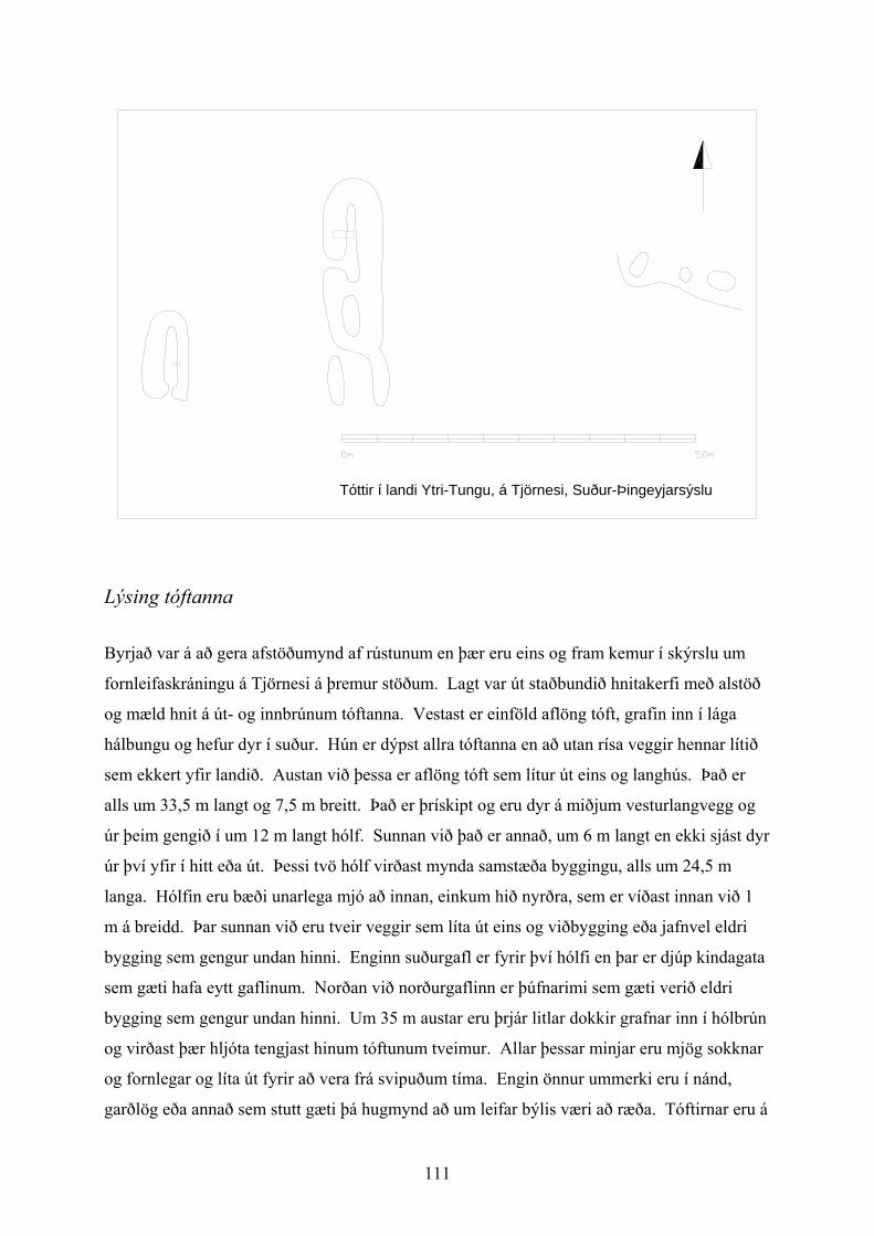
111
Tóttir í landi Ytri-Tungu, á Tjörnesi, Suður-Þingeyjarsýslu
Lýsing tóftanna
Byrjað var á að gera afstöðumynd af rústunum en þær eru eins og fram kemur í skýrslu um
fornleifaskráningu á Tjörnesi á þremur stöðum. Lagt var út staðbundið hnitakerfi með alstöð
og mæld hnit á út- og innbrúnum tóftanna. Vestast er einföld aflöng tóft, grafin inn í lága
hálbungu og hefur dyr í suður. Hún er dýpst allra tóftanna en að utan rísa veggir hennar lítið
sem ekkert yfir landið. Austan við þessa er aflöng tóft sem lítur út eins og langhús. Það er
alls um 33,5 m langt og 7,5 m breitt. Það er þrískipt og eru dyr á miðjum vesturlangvegg og
úr þeim gengið í um 12 m langt hólf. Sunnan við það er annað, um 6 m langt en ekki sjást dyr
úr því yfir í hitt eða út. Þessi tvö hólf virðast mynda samstæða byggingu, alls um 24,5 m
langa. Hólfin eru bæði unarlega mjó að innan, einkum hið nyrðra, sem er víðast innan við 1
m á breidd. Þar sunnan við eru tveir veggir sem líta út eins og viðbygging eða jafnvel eldri
bygging sem gengur undan hinni. Enginn suðurgafl er fyrir því hólfi en þar er djúp kindagata
sem gæti hafa eytt gaflinum. Norðan við norðurgaflinn er þúfnarimi sem gæti verið eldri
bygging sem gengur undan hinni. Um 35 m austar eru þrjár litlar dokkir grafnar inn í hólbrún
og virðast þær hljóta tengjast hinum tóftunum tveimur. Allar þessar minjar eru mjög sokknar
og fornlegar og líta út fyrir að vera frá svipuðum tíma. Engin önnur ummerki eru í nánd,
garðlög eða annað sem stutt gæti þá hugmynd að um leifar býlis væri að ræða. Tóftirnar eru á
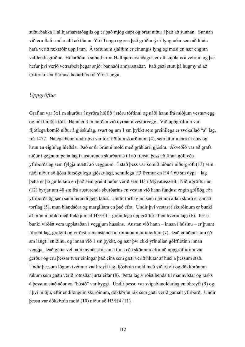
112
suðurbakka Hallbjarnarstaðagils og er það mjög dúpt og bratt niður í það að sunnan. Sunnan
við eru flatir móar allt að túnum Ytri Tungu og eru það gróðurrýrir lyngmóar sem að hluta
hafa verið ræktaðir upp í tún. Á tóftunum sjálfum er einungis lyng og mosi en nær enginn
valllendisgróður. Hólaröðin á suðurbarmi Hallbjarnarstaðagils er oft snjólaus á vetrum og þar
hefur því verið vetrarbeit þegar snjór bannaði annarsstaðar. Það gæti stutt þá hugmynd að
tóftirnar séu fjárhús, beitarhús frá Ytri-Tungu.
Uppgröftur
Grafinn var 3x1 m skurður í nyrðra hólfið í stóru tóftinni og náði hann frá miðjum vesturvegg
og inn í miðja tóft. Hann er 3 m norðan við dyrnar á vesturvegg. Við uppgröftinn var
fljótlega komið niður á gjóskulag, svart og um 1 sm þykkt sem greinilega er svokallað “a” lag,
frá 1477. Nálega beint undir því var torf í öllum skurðinum (4), sem lítur meira út eins og
hrun en eiginleg hleðsla. Það er úr brúnni mold með gráblárri gjósku. Ákveðið var að grafa
niður í gegnum þetta lag í austurenda skurðarins til að freista þess að finna gólf eða
yfirborðslag sem fylgja mætti að veggnum. Í stað þess var komið niður í niðurgröft (13) sem
náði niður að ljósu forsögulegu gjóskulagi, sennilega H3 fremur en H4 á 60 sm dýpi – lag
þetta er þó gulleitara en það sem greint hefur verið sem H3 í Mývatnssveit. Niðurgröfturinn
(12) byrjar um 40 sm frá austurenda skurðarins en vestan við hann fundust engin gólflög eða
yfirborðslög sem sannfærandi geta talist. Undir torflaginu sem nær um allan skurð er annað
torflag (5), mun blandaðra og marglitara en það efra. Undir því vestast í skurðinum er bunki
af brúnni mold með flekkjum af H3/H4 – greinilega uppgröftur af einhverju tagi (6). Þessi
bunki virðist vera uppistaðan í veggjum hússins. Austan við hann – innan í húsinu – er þunnt
lífrænt lag, gráleitt og virðist samanstanda af rotnuðum jurtaleifum (7). Það er aðeins um 65
sm langt í sniðinu, og innan við 1 sm þykkt, og nær því ekki yfir allan gólfflötinn innan
veggja. Það getur vel hafa myndast á sama tíma eða skömmu eftir að uppgröfturinn var
gerður og eru þessar tvær einingar það eina sem gæti verið hlutar af húsi á þessum stað.
Undir þessum lögum tveimur var hreyft lag, ljósbrún mold með viðarkoli og dökkbrúnum
rákum sem gætu verið rotnaðar jurtaleifar (8). Þetta lag virðist benda til mannvistar og rasks
á þessum stað áður en “húsið” var byggt. Undir þessu var svipað moldarlag en óhreyft (9) og
í því miðju, eftir endilöngum skurðinum, dökkbrún rák sem gæti verið gamalt yfirborð. Undir
þessu var dökkbrún mold (10) niður að H3/H4 (11).
113
Norðursnið skurðar í tóft við Höfða í landi Ytri-Tungu á Tjörnesi. / Section in structure at Höfði in Tjörnes. Skýringar / Legend:
1. Grasrót / Topsoil 2. Dökkbrún fokmold með slitróttu svörtu gjóskulagi – V-1717? / Dark brown sandy silt. Aeolian with
traces of dark tephra – V-1717? 3. “a” lagið frá 1477 / “a” tephra from 1477 4. Torfhrun, með linsum af blágrárri gjósku (H-1300?) / Turf debris with blueish-grey stripes of tephra (H-
1300?) 5. Torfhrun, ljósleitara og meira hrært en 4./ Turf debris. Lighter brown and more mixed than 4. 6. Uppmokstur. Gulbrún mold með dílum af H3 (eða H4). / Upcast. Yellowbrown silt with flecks of H3
(or H4) 7. Gráleitt lífrænt lag – yfirborð. / Grey organic layer – surface. 8. Lítillega hreyft lag með dökkbrúnum lífrænum linsum. / Sligtly mixed anthropogenic soil with dark
brown organic lenses. 9. Óhreyft – grábrún mold m. dökkbrúnni lífrænni rák, e.t.v. gamalt yfirborð. / Natural – brownish grey
silt with dark brown organic stripe – old land surface? 10. Óhreyft – gulbrún mold. / Natural – yellow brown silt. 11. H3 (eða H4). / H3 (or H4). 12. Skurður. / Cut. 13. Fylling í skurði, grábrún mold, sennilega fokmold. / Fill of 12 – homogenous greybrown silt, probably
aeolian.
Þegar ljóst var að í þessum skurði væri ekki að finna ótvíræðar vísbendingar um mannabústað
var ákveðið að grafa minni holu í vestustu bygginguna, enda gæti þar verið um að ræða
skepnuhús eða a.m.k. skýrari leifar sem gefið gætu vísbendingar um hlutverk þessara tófta. Sú
hola gaf þó ennþá minni upplýsingar. Undir “a” laginu var þar annað gjóskulag, blágrátt lag
sem sést í torfi í hinum skurðinum. Undir því er lítillega hreyfð mold en þar undir óhreyft um
90 sm undir yfirborði.
Niðurstöður
Tóftirnar við Hallbjarnarstaðagil eru eldri en 1477 og sennilega mun eldri. Í þeim eru engin
gólflög eða yfirborðslög sem gefið gætu til kynna hvert hlutverk þeirra var. Ekki eru
114
eiginlegir hlaðnir veggir í stóru tóftinni, heldur aðeins moldarhrúga og ofan á henni torf sem
hugsanlega hefur verið jafnað út. Vestari tóftin er sennilega að mestu niðurgrafin en
könnunarholan í henni náði ekki út á veggi. Ekki er heldur útilokað að stóra tóftin sé
niðurgrafin en skurðurinn í henni náði ekki útfyrir “vegginn” svo að ganga mætti úr skugga
um það. Ljóst er að mannvist hefur hafist á þessum stað áður en byggingaframkvæmdir
hófust, hugsanlega ræktun af einhverju tagi. Síðan hefur verið mokað upp í lágan og mjóan
vegg og mjúkt yfirborðslag myndast innan hans. Annaðhvort hefur verið torfhleðsla ofan á
þessu sem síðar var rutt niður og jafnað yfir tóftina eða að einhverskonar framkvæmdir með
torf hafa átt sér stað eftir að notkun “hússins” lauk. Skömmu fyrir 1477 hefur svo verið
gerður skurður í miðri tóftinni – hugsanlega eftir henni endilangri og má vera að það séu
merki hans sem nú sjást á yfirborði sem innanmál tóftarinnar.
Óhugsandi er að þessar byggingaleifar séu eftir mannabústað og ólíklegt að um
skepnuhús sé að ræða. Eina skýringin sem gengur upp er að stóra tóftin a.m.k sé upphaflega
heystæði. Lágum veggjum hefur verið hróflað upp og heyið skilið eftir lífrænu rákina innan
við þá. Torfið þar ofan á er þá heytorf sem skilið hefur verið eftir ofan í tóftinni eftir að hætt
var að nota hana – og ósennilegt er að það hafi verið mjög lengi. Það skýrir þessa tilgátu að
staðurinn er á berangri, stendur hátt og er opinn fyrir vindum. Eftir að hætt var að nota
staðinn sem heystæði hefur síðan verið grafinn skurður eftir því endilöngu og er það hann sem
gefur tóftinni útlit fyrir að vera hús.
Sama skýring getur tæplega átt við vestustu tóftina, enda eru á henni að því er virðist
mjög skýrar dyr, og enn síður hvompurnar þrjár austan við. Þessar leifar eru því ekki
fullskýrðar og verða að teljast með þeim sérkennilegri sem rannskaðar hafa verið á Íslandi.
Summary
By the ravine Hallbjarnarstaðagil, in the property of Ytri-Tunga in Tjörnes, north of the
modern town Húsavík, a set of ancient ruins was surveyed in 1999. The site consists of three
structures, one of which looks like a long-house partitioned into three units, in all 33,5 m long
and 7,5 m wide. It was the unusual size and shape of this structure which prompted a
preliminary investigation carried out in August 2001 with the aim to establish wether this was
in fact a Viking age/medieval dwelling.
115
A trench placed on the inside of what looked like the structure’s western wall revealed
that it was overlaid by the “a” tephra, dated to AD 1477. Underneath this was a layer of turf
debris and underneath that a thin organic layer, interpreted as decomposed hay. Sometime
after 1477 a trench, presumably running along the centre of the ruin had been dug into these
layers. This was all that was found inthis trench. A smaller trench dug into the side of a
neighbouring structure was even less revealing with only a trace of anthropogenic deposits
underneath a tephra (not seen in the larger trench) which was under the “a” layer.
The large hall shaped structure is clearly not a building and it is suggested that it is the
remains of a place where hay was stored. The location is on a high ridge, which is windy and
often free of snow during the winter. It makes sense that hay was stored there as it would dry
in the wind and could be used to supplement the fodder of the animals grazing the bare parts
during winter. The layer of turf is then the remains of the turves laid on the hay stack to
protect it and left after the last stack had been removed. This leaves the later trench and the
other structures unexplained, but it is clear that this is not an early settlement site.
116
Orri Vésteinsson Fornleifarannsóknir í Sveigakoti og víðar í Suður Þingeyjarsýslu sumarið 2001 – Ágrip
Uppgröftur á Sveigakoti í Mývatnssveit stóð yfir dagana 23. júlí til 17. ágúst 2001. Grafið var
á þremur svæðum:
Uppgrefti á svæði M, öskuhaug, var lokið. Þar hafði verið grafið frá 1999 og stærsti
hluti haugsins fjarlægður árið 2000. Nú var grafið mest til vesturs og var þar allþykkt lag
undir ólívugrænu gjóskulagi sem talið er vera frá um 950. Náðust um 50 l af beinum úr því
lagi en í allt var dýrabeinafengur þessa árs mun minni en fyrri ár. Beinin hafa ekki verið talin
en af rúmmáli að dæma er þó marktækt magn bæði úr lögum yfir og undir ólívugrænu
gjóskunni og frá svæði T, sem grafið var upp sumarið 2000 og er yngra en hin tvö.
Uppgröftur á svæði S hélt áfram og kom í ljós að skálabygging sú sem grafin var upp
sumarið 2000 var umbygging á stærra húsi sem náð hefur lengra til austurs og suðurs. Sá
eldri skáli hefur verið um 20 m að lengd og um 4,5 m að breidd, en suðurmörk hans eru mjög
óljós. Í austurenda er flórlögn í miðju húsi og kolagólf sitthvorumegin við hana. Hugsanlegt
er að um leifar fjóss sé að ræða. Einnig komu í ljós merki um eldra eldstæði sem hefur verið
skemmt af því yngra. Þessu eldra stigi skálans tilheyrir einnig sáfarið sem að hluta kom í ljós
sumarið 2000. Í ljós kom að milli þessara tveggja aðalbyggingarskeiða eru ýmis
mannvistarlög sem hafa orðið til eftir að eldri skálinn var yfirgefinn en áður en sá yngri var
byggður. Svo virðist sem eldra húsið hafi verið yfirgefið, en síðan notað um stutt skeið á
meðan þakið hékk ennþá uppi og eins hefur verið þar einhver mannaferð og eldar tendraðir
eftir að þakið hrundi. Þetta bendir til að Sveigakot hafi verið yfirgefið um hríð, e.t.v. á 11.
öld, og verið notað um skeið sem sel eða beitarhús en síðan hafi byggð hafist á ný á 12. öld en
aðeins varað um skamma hríð. Grafið var niður að gólflögum eldra skálans en þau ekki
fjarlægð og bíður það sumarsins 2002.
Hafinn var uppgröftur á svæði T, þar sem lítill öskuhaugur frá 11. öld var grafinn upp
sumarið 2000. Undir öskuhaugnum kom í ljós mjög lítið (2,5x2,5 m) jarðhús, með eldstæði
og torfbekkjum. Hús þetta hefur verið notað um alllanga hríð en það er sjálft byggt ogan í
eldri jarðhús, tvö eða þrjú, sem liggja hlið við hlið á suðurenda bæjarstæðisins. Þessar
byggingar eru mun eldri heldur en skálinn á svæði S og tilheyra tímabilinu 950-1050.
117
Gerð var könnun á útbreiðslu mannvistarleifa milli S og T og kom í ljós að undir
svæði M eru ekki neinar byggingar, en nær S var komið niður á gólflög á tveimur stöðum og
er ljóst að þar eru samfelldar byggingaleifar á svæði sem er um 15x40 m frá norðri til suðurs.
Auk uppgraftar á Sveigakoti sjálfu voru gerðar jarðvegsathuganir í nágrenni
bæjarstæðisins. Skoðuð voru 8 jaðrvegssnið í Sellöndum sunnan við Sveigakot, flest í túni
Oddastaða, en þar eru talsverð ummerki um ræktun upp að “a” gjóskunni frá 1477. Einnig
var ólívugræna gjóskan kortlögð á Mývatnsheiði og suður um Bárðardal. Í kringum
Svartárkot sást gjóskan í sniðum ofan við hina eiginlegu landnámsgjósku og styður það þá
túlkun að um sé að ræða áður óþekkt lag frá 10. öld, þó nákvæmari tímasetningu vanti enn.
Litur gjóskunnar er heldur dekkri en landnámslagsins og hún hefur minna af kristalbrotum en
það og má nú telja öruggt að um tvö ólík lög er að ræða, það neðra sé landnámsgjóskan en hið
efra frá miðri 10. öld og hefur það verið nefnt V~950 .
Ennþá hafa ekki komið í ljós byggingaleifar sem með vissu er hægt að tengja elsta
ábúðarskeiði Sveigakots, þ.e. á 9. og 10. öld, en þá var blómatími bæjarins ef marka má
dýrabeinagreiningar. Byggingaleifar þær sem grafnar hafa verið fram eru frá 11. og 12. öld
og undir það síðasta viðrist byggðin hafa verið orðin stopul. Hugsanlegt er að Sveigakot hafi
um 1100 orðið að seli og síðan byggst á ný um stutt skeið um miðja 12. öld en eftir það hefur
staðurinn verið yfirgefinn endanlega.
Hinn skýri tímarammi sem fengist hefur af gjóskulögum og C14 greiningum varpar nýju
ljósi á þróun húsagerðar. Ný tegund jarðhúss frá 11. öld hefur komið í ljós, og yngsti skálinn
er af gerð sem komið hefur í ljós annarsstaðar, m.a. í Herjólfsdal og á Snjáleifartóttum í
Þjórsárdal. Þessi gerð, sem einkennist af beinum grjóthlöðnum veggjum og mun mjórri
rýmum (<3 m) en tíðkuðust í víkingaaldrarhúsum, hefur þróast um allt land á 11. og 12. öld
og er greinilega “týndi hlekkurinn” milli eldaskála víkingaaldar og íslenska torfbæjarins.
Allt bendir til að búskapur hafi staðið með blóma á Sveigakoti á 9. og 10. öld en um 1000
fer að halla undir fæti þó enn hafi þar verið búið – e.t.v. með hléum – í um 200 ár. Ekki er
hægt að rekja hnignun Sveigakots beint til umhverfisþátta, a.m.k. ekki stórfellds uppblásturs
því hann hófst ekki á þessu svæði fyrr en eftir 1500. Settar hafa verið fram tilgátur um að
hnignun Sveigakots eigi sér félagslegar og pólitískar orsakir og tengist valdasamþjöppun í
Mývatnssveit á 11. öld.
Með rannsóknum á Sveigakoti hefur fengist mun skýrari mynd af upphafi íslensks
samfélags. Verkefnið er að upplagi hugsað til að afla samanburðarefnis fyrir Hofstaði og
hefur það eitt skilað raunhæfara mati á gögnum frá Höfstöðum og að mörgu leyti sýnt þau í
118
alveg nýju ljósi. Svo vel vill til að byggð í Sveigakoti stóð mun lengur en notkun
Hofstaðaskálans, Sveigakot var stofnað fyrr og þar var enn búið eftir að Hofstaðaskálinn var
yfirgefinn. Þar með fæst lengri tímalína, en líka innsýn í önnur viðfangsefni en Hofstaðir
varpa ljósi á, einkum hvað varðar húsagerð og þróun hennar, búskap á meðalbýli og um
hnignun og byggðaröskun sem víða um land fylgdi í kjölfar landnámsaldar. Rannsóknir á
samspili manns og náttúru á Sveigakoti benda til að þar sé um að ræða mun flóknari ferli en
hingað til hefur verið talið. Þegar er ljóst að uppblæstri verður ekki kennt um eyðingu
byggðarinnar en vera má að rýrnun jarðvegs og gróðurs sem leiddi til byggðaeyðingarinnar
hafi einnig verið undanfari uppblástursins þó að allt að 300 ár skilji að í tíma. Ef það reynist
réttur skilningur þá hefur það í för með sér alveg nýja sýn á orsakir jarðvegseyðingar á
Íslandi.
Sumarið 2001 voru gerðir könnunarskurðir á þremur stöðum til viðbótar: Hjá Höfða í
landi Ytri Tungu á Tjörnesi, í Selhaga í landi Haganess við Mývatn og í Hrísheimum á
Mývatnsheiði. Í ljós kom að rústin á Höfða var ekki mannabústaður en í Selhaga og
Hrísheimum fundust ótvíræð merki um heilsársbúskap á miðöldum. Í Selhaga hefur verið
buggð frá 10. öld og fram á þá 13. en ekki verður fullyrt að þar hafi verið heilsársbyggð allan
þann tíma. Tímasetning Hrísheima er ekki jafnvel afmörkuð en gripir þeir sem þar hafa
fundist benda eindregið til Víkingaaldar en mannvirkjaleifarnar sýna að þar hlýtur að hafa
verið búið sýnu lengur en í Sveigakoti – ef til vill fram á seinni hluta miðalda. Á báðum
stöðum var grafið í öskuhauga og fannst mikið magn af vel varðveittum dýrabeinum. Fyrstu
niðurstöður greininga á þeim benda til að þessi staðir fylgi sama munstri og komið hefur í ljós
á Hofstöðum og Sveigakoti og vekur einkum athygli að á öllum þessum stöðum er talsvert
magn af sjófiski og sjófugli saman við viðiskap í heimahögum, silung og rjúpu. Í
Hrísheimum er mikið magn svínabeina, hið hæsta hlutfall sem enn hefur fundist á Íslandi, en
á óvart kom að í Selhaga var sáralítið um endur og raunar meira af sjófulgi en öndum, þó
aðstæður til andaveiða séu óvíða betri á landinu en einmitt þar. Það bendir ótvírætt til að
öndum hafi meðvitað verið hlíft við veiðum til að varðveita eggverin, en eggjaskurn finnst í
miklum mæli á öllum stöðunum fjórum sem nú hafa verið rannsakaðir í Mývatnssveit.