Embed Size (px)
Citation preview
GEOLOGIC MAP OF THE MANTI 7.5-MINUTEQUADRANGLE, SANPETE COUNTY, UTAH
by
Malcolm P. Weiss (deceased)Preston Cloud Research Laboratory
University of CaliforniaSanta Barbara, California 93106
and
Douglas A. SprinkelUtah Geological Survey
1594 West North Temple Street,Salt Lake City, Utah 84114-6100
MAP 188UTAH GEOLOGICAL SURVEYa division ofUtah Department of Natural Resources2002
�������������������������
������������ �
WASHINGTON
IRON
BEAVER
KANE
GARFIELD
SAN JUAN
GRAND
UINTAHCARBON
DUCHESNE
WASATCH
DAGGETTSUMMIT
UTAH
SALT LAKE
SANPETE
CACHERICH
WEBERMORGAN
DAVIS
BOX ELDER
TOOELE
JUAB
MILLARDSEVIER
WAYNE
EMERY
PIUTE
GREAT SALT LAKE
UTAH LAKE
Gre
en R
iver
Col
orad
o R
iver
GEOLOGIC MAP OF THE MANTI 7.5-MINUTEQUADRANGLE, SANPETE COUNTY, UTAH
by
Malcolm P. Weiss (deceased)Preston Cloud Research Laboratory
University of CaliforniaSanta Barbara, California 93106
and
Douglas A. SprinkelUtah Geological Survey
1594 West North Temple Street,Salt Lake City, Utah 84114-6100
MAP 188Utah Geological Surveya division of
Utah Department of Natural Resources2002
ISBN 1-55791-588-1
Although this product represents the work of professional scientists, the Utah Department of Natural Resources, Utah Geo-logical Survey, makes no warranty, stated or implied, regarding its suitability for a particular use. The Utah Department ofNatural Resources, Utah Geological Survey, shall not be liable under any circumstances for any direct, indirect, special,incidental, or consequential damages with respect to claims by users of this product.
STATE OF UTAHMichael O. Leavitt, Governor
DEPARTMENT OF NATURAL RESOURCESRobert Morgan, Executive Director
UTAH GEOLOGICAL SURVEYRichard G. Allis, Director
UGS BoardMember Representing Robert Robison (Chairman) ...................................................................................................... Minerals (Industrial)Geoffrey Bedell.............................................................................................................................. Minerals (Metals) Stephen Church .................................................................................................................... Minerals (Oil and Gas)E.H. Deedee O’Brien ........................................................................................................................ Public-at-LargeCraig Nelson ............................................................................................................................ Engineering Geology Charles Semborski ............................................................................................................................ Minerals (Coal)Ronald Bruhn .............................................................................................................................................. ScientificStephen Boyden, Trust Lands Administration ............................................................................. Ex officio member
UTAH GEOLOGICAL SURVEY
The UTAH GEOLOGICAL SURVEY is organized into five geologic programs with Administration and Editorial providing neces-sary support to the programs. The ENERGY & MINERAL RESOURCES PROGRAM undertakes studies to identify coal, geothermal,uranium, hydrocarbon, and industrial and metallic resources; initiates detailed studies of these resources including mining district and fieldstudies; develops computerized resource data bases, to answer state, federal, and industry requests for information; and encourages the pru-dent development of Utah’s geologic resources. The GEOLOGIC HAZARDS PROGRAM responds to requests from local and state gov-ernmental entities for engineering-geologic investigations; and identifies, documents, and interprets Utah’s geologic hazards. The GEO-LOGIC MAPPING PROGRAM maps the bedrock and surficial geology of the state at a regional scale and at a more detailed scale byquadrangle. The GEOLOGIC INFORMATION & OUTREACH PROGRAM answers inquiries from the public and provides informa-tion about Utah’s geology in a non-technical format. The ENVIRONMENTAL SCIENCES PROGRAM maintains and publishes recordsof Utah’s fossil resources, provides paleontological and archeological recovery services to state and local governments, conducts studies ofenvironmental change to aid resource management, and evaluates the quantity and quality of Utah’s ground-water resources.
The UGS Library is open to the public and contains many reference works on Utah geology and many unpublished documents onaspects of Utah geology by UGS staff and others. The UGS has several computer databases with information on mineral and energyresources, geologic hazards, stratigraphic sections, and bibliographic references. Most files may be viewed by using the UGS Library. TheUGS also manages the Utah Core Research Center which contains core, cuttings, and soil samples from mineral and petroleum drill holesand engineering geology investigations. Samples may be viewed at the Utah Core Research Center or requested as a loan for outside study.
The UGS publishes the results of its investigations in the form of maps, reports, and compilations of data that are accessible to the pub-lic. For information on UGS publications, contact the Natural Resources Map/Bookstore, 1594 W. North Temple, Salt Lake City, Utah84116, (801) 537-3320 or 1-888-UTAH MAP. E-mail: [email protected] and visit our web site at mapstore.utah.gov.
UGS Editorial StaffJim Stringfellow.................................................................................................................................................EditorVicky Clarke, Sharon Hamre...............................................................................................................Graphic ArtistsPatricia H. Speranza, James W. Parker, Lori Douglas ..........................................................................Cartographers
The Utah Department of Natural Resources receives federal aid and prohibits discrimination on the basis of race, color, sex, age, national origin, or disability. Forinformation or complaints regarding discrimination, contact Executive Director, Utah Department of Natural Resources, 1594 West North Temple #3710, Box 145610,Salt Lake City, UT 84116-5610 or Equal Employment Opportunity Commission, 1801 L Street, NW, Washington DC 20507.
Printed on recycled paper 8/02
ABSTRACT
The Manti quadrangle lies in a region of structural tran-sition between the extended lithosphere of the Basin andRange Province and the moderately deformed ColoradoPlateau. In Late Cretaceous time this region was the leadingedge of the Sevier orogenic belt. Bedrock strata exposedwithin the quadrangle range in age from Middle Jurassic(Callovian) through late Eocene. Jurassic strata antedateSevier deformation and are exposed only within a zone ofimbricate reverse faults along the eastern foot of the SanPitch Mountains (Gunnison Plateau), where two formationshave a maximum exposed thickness of about 1,600 feet (488m). Cretaceous strata (Aptian to Turonian) deposited in aforeland basin associated with the Sevier orogenic belt arelocally present in outcrop and reached by wells in the San-pete Valley. This part of the section is thinner in this quad-rangle than farther north and the maximum exposed thick-ness of Lower Cretaceous beds is only about 512 feet (156m). Only about 400 feet (122 m) of Upper Cretaceous stratacrop out in the Manti quadrangle. These Mesozoic beds weredeformed by Sevier shortening and reverse faults have cutthem into steeply dipping slabs along the front of the plateau.
The synorogenic North Horn Formation was depositedunconformably on older rocks between late Campanian andearly Eocene time, during intermittent Sevier deformation. Itrepresents the fill of a piggyback basin developed on thehanging wall of the Gunnison thrust system, which underliesthe San Pitch Mountains. The North Horn thickens westwardfrom a pinch-out in the subsurface beneath Sanpete Valley toa maximum of 945 feet (288 m) on the east flank of the SanPitch Mountains, but it is even thicker west of the Mantiquadrangle in the central part of the mountains. Intraforma-tional unconformities and paleocurrent indicators in theNorth Horn beds record syndepositional shortening anduplift. The formation is divided into four informal membersin the quadrangle; the upper three are Tertiary in age.
Eocene strata include the Flagstaff, Colton, Green River,and Crazy Hollow Formations, with a total maximum thick-ness of 2,282 feet (696 m). These units postdate most Sevi-er shortening; however, minor, west-vergent back-thrustingduring the later stages of the Sevier orogeny deformed NorthHorn, Flagstaff, and Colton strata. Although late-stage short-ening of the Sevier orogeny in central Utah was coincidentwith deformation of the Laramide orogeny, we saw little evi-dence for Laramide deformation in the quadrangle. The mu-tual development of Sanpete Valley and the Wasatch mono-cline is generally attributed to basin-and-range extension, butthe early development of the monocline may have begun dur-ing Laramide time.
Surficial deposits are mostly restricted to Sanpete Valleyand to unstable slopes and stream channels on the plateau.Mass-wasting deposits are conspicuous on the slopes of themountains, particularly on the fine-grained units of the NorthHorn, Colton, and Green River Formations. Geologic re-sources are few in the quadrangle; sand and gravel from theQuaternary deposits and water in Sanpete Valley are the mostimportant. Geologic hazards in the area include earthquakes,landslides, and floods and their resultant deposits; flood dan-gers are the most important because of their greater fre-quency.
INTRODUCTION
The Manti quadrangle encompasses the southeast-cen-tral part of the San Pitch Mountains (Gunnison Plateau) andmost of the width of Sanpete Valley, which lies between theGunnison and the Wasatch Plateaus. Throughout this text“the plateau” refers to the Gunnison Plateau. The city ofManti, the county seat of Sanpete County, lies in the south-east corner of the quadrangle, and houses the majority of per-manent inhabitants of the quadrangle. The lowest elevationin the quadrangle is the transient level - about 5,390 feet
GEOLOGIC MAP OF THE MANTI 7.5-MINUTEQUADRANGLE, SANPETE COUNTY, UTAH
by
Malcolm P. Weiss (deceased)Preston Cloud Research Laboratory
University of CaliforniaSanta Barbara, California 93106
and
Douglas A. SprinkelUtah Geological Survey
1594 West North Temple Street,Salt Lake City, Utah 84116
(1,643 m) - of the impounded San Pitch River (GunnisonReservoir) in the south-central part of the quadrangle. Thehighest elevation, approximately 8,570 feet (2,612 m) at thenorthwest corner of the quadrangle, is part of the crest of theplateau along the western edge of the quadrangle. The totalrelief within the Manti quadrangle is thus about 3,180 feet(970 m) and it is concentrated along the mountain frontwhere cliffs and steep slopes face east into Sanpete Valley.Three large drainage systems - Dry, Maple, and DodgeCreeks - cut the eastern flank of the plateau; the largest isMaple Creek, but only Dry Creek is a permanent stream. Allsurface water, even in Antelope Valley, drains to the SanPitch River and thence out of Sanpete Valley. Each canyonexposes sections of the mostly Tertiary beds of the body ofthe plateau. Steep gulches draining the edge of the plateauexpose the mostly Mesozoic beds contained in the complex-ly deformed belt at the toe of the plateau.
Agriculture - grazing or the growing of feed for livestock -is the principal use of the land in the quadrangle; forestry isquite subordinate to agriculture. The highlands of the quad-rangle, unlike the northern parts of the Gunnison Plateau, arealmost entirely privately owned. The plateau is an importantsource of both surface and subsurface water for the lowlands,although the east side of the valley and the city of Manti arerecharged from the Wasatch Plateau on the east.
Parts of the Manti quadrangle have been mapped previ-ously. The geologic map of the Wasatch Plateau and SanpeteValley area (Spieker, 1949a) included the eastern margin ofthe Gunnison Plateau. Babisak (1949) mapped the south-eastern part of the Gunnison Plateau. Katherman (1949)mapped the Flagstaff Limestone and Birsa (1973) mappedthe North Horn Formation along the east front of the plateau.Geologic maps of adjacent quadrangles include those ofWales on the north (Lawton and Weiss, 1999), Sterling on thesouth (Weiss, 1994), Gunnison on the southwest (Mattox,1992), Hells Kitchen Canyon Southeast on the west (Mat-tox, 1987) and Chriss Canyon on the northwest (Weiss andothers, in press). Witkind and others (1987) published a1:100,000-scale map that included the entire Manti quadran-gle. A geologic map of the Manti quadrangle was compiledat a scale of 1:24,000 in 1978 and 1979 by Weiss (westernthird) and Witkind (eastern two-thirds) for publication at1:100,000 (Witkind and others, 1987). Weiss and Sprinkelrevised that work and completed new mapping in 1991,1992, and 1993.
Numerous topical studies have been carried out within ornear the Manti quadrangle. Spieker (1946, 1949b), Weiss(1982a), Lawton (1982, 1985), and Weiss and Roche (1988)presented structural cross sections. Gilliland (1963) firstdescribed the anticlinal structure of Sanpete Valley and itsflanking plateau; he called that structure the "Sanpete-SevierValley anticline.” Gundersen and Gilliland (1967) preparedisopach maps of the major rock units involved in the anti-cline, called an antiform in this report because the core of theantiform consists of the complexly faulted and folded Arapi-en Shale, whose beds are not simply folded upward. How-ever, the strata above the Arapien Shale are folded upward,which defines the anticlinal form. Numerous stratigraphicstudies making reference to Mesozoic and Cenozoic strataexposed in the quadrangle are cited in the stratigraphic sec-tion of this report.
Late Mesozoic and Paleogene strata exposed in the
Manti quadrangle provide critical tests of the tectonic devel-opment of the region, which lies athwart the boundarybetween the Basin and Range Province and ColoradoPlateau. During late Mesozoic time the easternmost edge ofthe Sevier fold-and-thrust belt lay along the trend of what isnow Sanpete Valley. Overturned and reverse-faulted Meso-zoic beds in the face of the plateau demonstrate back-thrust-ing of strata within the upper plate of the Gunnison thrust.Sedimentary features and structure of the North Horn For-mation, particularly as revealed in the Wales quadrangle,adjacent on the north, demonstrate coeval deformation anddeposition that constrain our interpretation of the style andages of deformation at the thrust front more precisely thanformerly possible (Lawton and Weiss, 1999).
STRATIGRAPHY
Bedrock strata exposed in the Manti quadrangle are fromMiddle Jurassic to Eocene in age and fall into three structur-al and stratigraphic categories: (1) Middle Jurassic marineand marginal marine strata and Lower Cretaceous mainlycontinental strata that predate local contractional deforma-tion are present along the foot of the east front of the Gunni-son Plateau in a zone of west-vergent, reverse-faulted blocksthat we call the zone of imbricate reverse faults. (2) UpperCretaceous to Eocene synorogenic continental strata (NorthHorn Formation) accumulated in a piggyback basin whoseeastern margin coincided roughly with the zone of imbricatereverse faults. North Horn rocks make up the body of theplateau and are deformed by the reverse faults in the plateaufront. Marine lithofacies of the Cretaceous beds lie to theeast and are found in this quadrangle only in the subsurfaceof Sanpete Valley. (3) Younger Eocene strata capping theplateau above the North Horn are largely late-orogenic lacus-trine and fluviatile beds deposited during waning stages ofthe Sevier orogeny in this region.
Surficial deposits within the quadrangle are largelyrestricted to Sanpete Valley and the major drainages of theplateau, but mass-wasting deposits are widespread on slopeswithin the plateau.
Jurassic System
Arapien Shale (Ja)
Only member E of the Arapien Shale, the fifth andyoungest of five members defined and described by Hardy(1952), is exposed in the quadrangle. In the Manti quadran-gle, the rock is a brick-red gypsiferous mudstone with minorthin layers of siltstone. Although bedding is generallyobscure, it can be observed with confidence in an anticline inSE1/4 section 4, T. 17 S., R. 2 E. The Arapien is well exposedin the adjacent Sterling quadrangle, where it contains salt(Weiss, 1994). Member E is marine in origin, and wasdeposited in a restricted basin in which a high rate of evapo-ration led to the formation of gypsum and halite crystals inthe bottom muds. The maximum exposed thickness of themember in the quadrangle is about 200 feet (61 m), whereasits exposed thickness in the vicinity is slightly more than 400feet (122 m) (Willis, 1986; Weiss, 1994). The Arapien Shaleprobably had a depositional thickness between 2,000 and
2 Utah Geological Survey

3,000 feet (610-914 m) (Sprinkel, 1994); however, it is 2,700feet (820 m) to more than 7,000 feet (2,100 m) in wellsdrilled in and surrounding the Manti quadrangle (Sprinkel,1994). Even the great thickness of Arapien drilled by wellsin the area may not reflect the maximum thickness in the coreof the antiform. The enormous thickness variation of theArapien is caused by structural complications, such as fold-ing, fault-repeated sections, and diapirism.
The contact with the underlying Member D is not ex-posed in the quadrangle. The upper contact has usually beenreported (for example, see Weiss, 1994) to be regionally con-formable with the Twist Gulch Formation. At several placesin the Manti quadrangle, however, a basal conglomerate - athin muddy conglomerate composed of angular granules - ofthe Twist Gulch lies atop member E of the Arapien Shale.The authors have found the same relationship on the westside of the plateau in the Chriss Canyon quadrangle, whichadjoins the northwest corner of the Manti quadrangle. Mem-ber E is Callovian in age, and the entire Arapien Shale isMiddle Jurassic (Bathonian to Callovian) (Imlay, 1980).
Twist Gulch Formation (Jt)
The Twist Gulch Formation crops out widely but dis-continuously in the zone of imbricate reverse faults; the mostrepresentative exposure is that at the mouth of Dry Canyon.It consists mostly of pale-red and reddish-brown calcareousmudstone and siltstone and has many beds of pinkish-gray towhite sandstone 2 to 4 feet (about 1 m) in thickness. Thesandstone beds form ribs and the mudstone and siltstone bedsmake reentrants in the profile of the outcrop. The sandstoneis mostly fine or medium grained, with some coarse grains,highly quartzose, and sometimes speckled or variegated withinclusions of red mudstone; some beds have hummockycross-bedding. Near the middle of the exposure, an intervalabout 68 feet (21 m) thick of mostly light-gray-weatheringsandstone with some mudstone interbeds is present in thewall of Dry Canyon (Roche, 1985) and lies in the TwistGulch throughout the plateau. The sandstone in this intervalis thinly laminated and exhibits trough cross-bedding local-ly; it is interpreted as a shoreface sand (Lawton and Weiss,1999), and is considered a western feather edge of the marineCurtis Sandstone.
The rest of the Twist Gulch beds are marginal marine inorigin and, although most are highly oxidized, they lackhalite and gypsum of the Arapien Shale. The highly coloredmudstone and siltstone beds are interpreted as tidal-flatdeposits, whereas the thick sandstone unit and the thin pale-pink or white sandstone beds represent either shore-face orsurf-zone deposits (Lawton and Weiss, 1999).
The basal contact with the Arapien Shale is exposed atseveral places in the quadrangle and is remarkable for thebasal conglomerate of dark-red grit and coarse sandstone,never more than a few feet thick. These are the first exam-ples of the clearly disconformable contact that we had everseen, but we have since found the same relation on the westside of the plateau. Although the basal contact with the Ara-pien Shale is well exposed locally, no depositional uppercontact with the Cedar Mountain Formation, which is uncon-formable regionally, is exposed in this quadrangle. TheTwist Gulch is overlain by various younger beds, all inunconformable or fault contact.
The maximum exposed thickness of the Twist Gulch in
the quadrangle is 1,150 feet (350 m). A moderately dippingcomplete section is 1,667 feet (508 m) thick on the northwestflank of the plateau (Auby, 1991). A less disturbed section ispresent in the Phillips Petroleum Price N well (SE1/4SE1/4section 29, T. 15 S., R. 3 E.) a few miles northeast of thequadrangle, where the formation has been interpreted as 956feet (292 m) thick by Sprinkel (1994) and 1,837 feet (566 m)thick by Lawton and Weiss (1999).
The Twist Gulch is Middle Jurassic (Callovian) in ageand a correlative of the Preuss Sandstone of northern Utah(Imlay, 1980). The Twist Gulch Formation is also correlativewith the San Rafael Group and contains strata recognizableas the Entrada, Curtis, and Summerville Formations (Imlay,1980; Willis, 1986; Lawton and Willis, 1987). As mentionedearlier, we consider the 68-foot-thick interval of shorefacesandstone within the Twist Gulch Formation in the GunnisonPlateau to be the equivalent of the Curtis Formation, but thishas not been demonstrated biostratigraphically. In addition,the beds above and below the shoreface sandstone in theManti quadrangle are lithologically similar and are not rec-ognizable as typical Entrada or Summerville rocks.
Cretaceous System
In the San Pitch Mountains and beneath Sanpete Valley,Lower Cretaceous continental strata lie unconformably onthe Twist Gulch Formation and beneath Upper Cretaceous(Cenomanian) marine and terrestrial strata of the upper partof the Indianola Group. In the Manti quadrangle these fluvi-atile rocks (Cedar Mountain and San Pitch Formations) areexposed only in the zone of imbricate reverse faults and arethus incomplete in thickness. The two formations are betterand more completely exposed in the Sterling quadrangle justto the south (Witkind and others, 1986; Weiss, 1994;Sprinkel and others, 1999). Sprinkel (1994) interpreted thethickness of this nonmarine Lower Cretaceous sectionbetween the Twist Gulch Formation and Cenomanian marinestrata (Sanpete Formation of the Indianola Group) as 1,372feet (418 m) in the Phillips Petroleum Price N well in theChester quadrangle (SE1/4SE1/4 section 29, T. 15 S., R. 3 E.)and 1,328 feet (405 m) in the Hanson Oil Moroni #1AX well(NW1/4SE1/4NW1/4 section 14, T. 15 S., R. 3 E.) 16 miles (26km) north-northeast of the Manti quadrangle. Lawtonreported thicknesses of 1,287 feet (392 m) and 2,190 feet(668 m), respectively, from these two wells (Lawton and oth-ers, 1993). The different interpreted thicknesses point up thedifficulty of selecting consistent contacts from logs in thisinterval of mudstone, sandstone, and conglomerate.
The Indianola Group in the San Pitch Mountains isentirely nonmarine in origin, but marine beds of the AllenValley Shale are present in the subsurface of Sanpete Valley.The group is Early to Late Cretaceous in age (Sprinkel andothers, 1999).
Cedar Mountain Formation (Kc, Ku)
The Lower Cretaceous Cedar Mountain Formation wasnamed by Stokes (1944, 1952) for beds of variegated mud-stone with intercalated sandstone, lacustrine limestone, and adiscontinuous basal conglomerate (Buckhorn Conglomerate)exposed at Cedar Mountain in the northwestern part of theSan Rafael Swell (section 9, T. 18 S., R. 10 E., Salt LakeBase Line and Meridian, Emery County, Utah). The Cedar
3Geologic map of the Manti 7.5-minute quadrangle, Sanpete County
Mountain Formation has since been formally subdivided intofour members by Kirkland and others (1997). West of theSan Rafael Swell, the Cedar Mountain Formation crops outin a belt of isolated (and undivided) exposures along the mar-gins of the Gunnison Plateau. In the Manti quadrangle theCedar Mountain exposures are near the base of the east frontof the Gunnison Plateau, in the structurally complex zonebetween Dry and Maple Canyons. It consists of variegatedmudstone and intercalated beds of pebbly sandstone and sub-ordinate lacustrine limestone. In addition, the Cedar Moun-tain contains thick zones of pedogenic carbonate that weath-er to calcareous nodules. The nodules and the “polishedstones” (thought to be gastroliths by Stokes, 1972) in the var-iegated mudstone are distinctive characteristics of the unit.The Cedar Mountain Formation was deposited in a fluvial-lacustrine environment (Yingling, 1987; Kirkland and others,1997; Schwans, 1988a, 1988b).
The Cedar Mountain Formation unconformably overliesthe marginal marine beds of the Middle Jurassic Twist GulchFormation west of the San Rafael Swell (Willis, 1986; Willisand Kowallis, 1988; Auby, 1991; Banks, 1991; Biek, 1991;Sprinkel, 1994; Weiss, 1994; Lawton and Weiss, 1999). Thiscontact is not exposed in the Manti quadrangle because offaulting, but the contact with the Twist Gulch was recognizedin the exploratory wells drilled within the quadrangle(Sprinkel, 1994; and table 1). Thus, in this region, UpperJurassic strata were either not deposited or were eroded priorto deposition of Lower Cretaceous beds (Sprinkel, 1994).This implies that a regional topographic high existed oremerged during Late Jurassic time. Near Little Salt Creek, inthe adjacent quadrangle northwest of the Manti quadrangle,the unconformable contact between the Cedar Mountain andthe Twist Gulch is angular, although this may be a local fea-ture (Weiss and others, in press). A basal Cedar Mountainconglomerate with interbedded sandstone dips about 20° lessthan the underlying fine-grained, reddish-orange sandstonebeds of the Twist Gulch. The upper contact is concordant,sharp, and well exposed, and is placed at the surface wherethe lowest thick, reddish-brown conglomerate of the SanPitch Formation lies on the massive red and gray mudstoneof the Cedar Mountain.
The Cedar Mountain Formation generally thickensnorthwestward across the San Rafael Swell from 164 to 513feet (50-160 m) (Craig, 1981; Yingling, 1987). It continuesto thicken slightly north and northwestward from about 617feet (188 m) in Salina Canyon to a maximum thickness of alittle more than 650 feet (200 m) under the Sanpete Valley(Sprinkel, 1994), although this represents apparent thick-nesses from drill holes in Sanpete Valley. Witkind and oth-ers (1986) measured 433 feet (132 m) of Cedar MountainFormation near Christianburg in the adjacent quadrangle tothe south, but that may not be the full thickness, for a faultmay cut the formation at that location (Weiss, 1994). Ananomalously thick section (1,686 feet [514 m]) of CedarMountain beds was drilled in the Mobil Larson #1 (table 1)in the quadrangle (Sprinkel, 1994); that great thickness wasprobably the result of structural thickening. From SanpeteValley the Cedar Mountain thins westward rapidly to about75 feet (23 m) along the western flank of the GunnisonPlateau (Sprinkel and others, 1999), although it is up to 680feet (207 m) in the northwest face of the plateau (Auby,1991; Biek, 1991). It pinches out near the West Hills, about
20 miles (32 km) west of the quadrangle (Sprinkel, 1994).The maximum thickness of the incomplete section exposedin the Manti quadrangle is 62 feet (19 m).
The age of the Cedar Mountain Formation in the SanRafael Swell is Barremian to late Albian-early Cenomanian(Katich, 1951, 1956; Craig, 1981; Tschudy and others, 1984;Kirkland and others, 1997, 1999). In Salina Canyon, theCedar Mountain Formation is likely Aptain to early Albian inage, based on fission-track dates obtained from zircon- andapatite-bearing bentonitic mudstones in the upper half of theformation (Willis and Kowallis, 1988) and the tentative cor-relation of these beds with beds of the Ruby Ranch Memberof the Cedar Mountain Formation to the east (Kirkland andothers, 1997, 1999). Samples collected near Christianburghave yielded palynomorphs of non-definitive Early Creta-ceous age (Witkind and others, 1986). The Cedar MountainFormation in the Gunnison Plateau is interpreted as Aptian tomiddle Albian in age. The Aptian age is based on the EarlyCretaceous palynomorphs from Cedar Mountain beds thatcrop out near Christianburg (south of the Manti quadrangle)and in east-central Utah, and the tentative correlation of thesebeds with beds of the Ruby Ranch Member of the CedarMountain in east-central Utah (Tschudy and others, 1984;Witkind and others, 1986; Kirkland and others 1997, 1999).The middle Albian upper age limit is based on the age of theoverlying San Pitch Formation.
Indianola Group (Ki)
Continental and marine strata that concordantly overliethe Cedar Mountain Formation and unconformably underliethe North Horn Formation in the Manti and adjacent quad-rangles are included in the Indianola Group. The groupincludes, in ascending order, the San Pitch and Sanpete For-mations, the Allen Valley Shale, and the Funk Valley andSixmile Canyon Formations (Spieker, 1946, 1949a; Weiss,1994; Sprinkel and others, 1999). Of these, only the SanPitch and Funk Valley Formations are exposed in the Mantiquadrangle, although all underlie Sanpete Valley. The SanPitch beds are in isolated outcrops in the structurally com-plex zone along the east front of the Gunnison Plateaubetween Dry and Maple Canyons; steeply dipping Funk Val-ley sandstone forms a tiny outcrop in the southeast corner ofthe quadrangle. The upper four formations, lying uncon-formably between the San Pitch and North Horn Formations,are the classic parts of Spieker’s Indianola Group (Spieker,1946, 1949a) and are described in adjacent and nearby quad-rangles (Banks, 1991; Weiss, 1994; Lawton and Weiss,1999). Not far to the east, beneath Sanpete Valley, the marinefacies of the Allen Valley Shale is present. East of SanpeteValley, in the Wasatch Plateau, the group has been dividedtraditionally into only the four upper formations (Spieker,1949a).
San Pitch Formation (Kspa, Kspb, Kspc, Ku)
The name San Pitch Formation is applied to reddish-brown conglomerate and interbedded mudstone and sand-stone that overlie the Cedar Mountain Formation concor-dantly and underlie the Sanpete Formation unconformably.It was defined by Sprinkel and others (1999), and replacesthe red conglomerate section of the Morrison(?) Formation(Spieker, 1949a), the upper unit of the “Cedar Mountain” of
4 Utah Geological Survey
5Geologic map of the Manti 7.5-minute quadrangle, Sanpete County
Ope
rato
rW
ell N
ame
AP
I N
umbe
rL
ocat
ion
Gro
und
For
mat
ion
Nam
eD
rille
d E
leva
tion
Thi
ckne
ssE
leva
tion
(ft
)D
epth
(ft
)(f
t)(f
t)
Mob
il O
ilL
arso
n #1
43-0
39-3
0008
SW1 /
4SE
1 /4
sect
ion
1,5,
434
Allu
vium
05,
434
680
Cor
pora
tion
T. 1
7 S.
, R. 2
E.
Flag
staf
f L
imes
tone
680
4,75
427
0N
orth
Hor
n Fo
rmat
ion
950
4,48
481
0Fu
nk V
alle
y Fo
rmat
ion
1,76
03,
674
912
Alle
n V
alle
y Sh
ale
2,67
22,
762
202
Sanp
ete
Form
atio
n2,
874
2,56
046
6Sa
n Pi
tch
Form
atio
n3,
340
2,09
498
5C
edar
Mou
ntai
n Fo
rmat
ion
4,32
51,
109
1,68
6Tw
ist G
ulch
For
mat
ion
6,01
1-5
771,
595
Ara
pien
Sha
le7,
606
-2,1
726,
437
TD
14,0
43-8
,609
Mob
il O
ilL
arso
n #2
43-0
39-3
0009
SW1 /
4SE
1 /4
sect
ion
1,5,
424
Allu
vium
05,
424
680
Cor
pora
tion
T. 1
7 S.
, R. 2
E.
Flag
staf
f L
imes
tone
680
4,74
471
5N
orth
Hor
n Fo
rmat
ion
1,39
54,
029
345
Funk
Val
ley
Form
atio
n1,
740
3,68
477
4T
D2,
514
2,91
0
Cha
ndle
r &
Mad
sen
7-25
43-0
39-3
0015
SW1 /
4N
E1 /
4se
ctio
n 25
,5,
427
Allu
vium
05,
427
670
Ass
ocia
tes
T. 1
7 S.
, R. 2
E.
Gre
en R
iver
For
mat
ion
(slid
e)67
04,
757
460
Gre
en R
iver
For
mat
ion
(in
plac
e)1,
130
4,29
747
4Fu
nk V
alle
y Fo
rmat
ion
1,60
43,
823
1,95
8A
llen
Val
ley
Shal
e3,
562
1,86
51,
256
Sanp
ete
Form
atio
n4,
818
609
349
San
Pitc
h Fo
rmat
ion
5,16
726
034
3T
D5,
510
-83
Cha
ndle
r &
Bar
ton
4-2
43-0
39-3
0012
NW
1 /4N
W1 /
4se
ctio
n 2,
5,
447
Allu
vium
05,
447
935
Ass
ocia
tes
T. 1
8 S.
, R. 2
E.
Gre
en R
iver
For
mat
ion
935
4,51
247
5A
rapi
en S
hale
1,41
04,
037
1,25
0T
D2,
660
2,78
7
Tabl
e 1.
Sim
plif
ied
logs
of
expl
orat
ory
wel
ls i
n th
e M
anti
qua
dran
gle.
6 Utah Geological Survey
Witkind and others (1986), the upper member of the PigeonCreek Formation (Schwans, 1988a, 1988b), and the unnamedbasal unit of the Indianola Group (Weiss and Roche, 1988;Weiss, 1994). It is divisible into three informal members (A,B, and C) that are distinctive in structure, composition, andtopography, and that can be recognized and traced regional-ly. Only members A and B of the San Pitch Formation areexposed in the Manti quadrangle because member C and thehigher units of the Indianola Group have been removed byerosion.
Where more fully exposed, the San Pitch is observed torest concordantly on the Cedar Mountain Formation.Although there is some interfingering of the two units, thecontact is placed at the base of the first reddish-brown cob-ble- and pebble-conglomerate bed (Sprinkel and others,1999). The lower contact of the San Pitch is generally dis-tinctive because the San Pitch commonly forms the firstprominent cliff above the smooth slopes of the Cedar Moun-tain Formation. It is one of the most obvious and best-described contacts used for mapping in the region (Hunt,1950; Hardy and Zeller, 1953; Witkind and Page, 1983;Witkind and others, 1986; Weiss and Roche, 1988; Auby,1991; Biek, 1991; Weiss, 1994; Fong, 1995). The lower con-tact is also easily recognized in the subsurface on lithologicand petrophysical logs (Sprinkel, 1994).
The San Pitch Formation is a fluvial unit that wasdeposited in a developing foredeep of the central Utah fore-land basin (Sprinkel and others, 1999). It is thickest alongthe west flank of the Gunnison Plateau and thins to the southand east. On the west flank of the plateau the formation is3,663 feet (1,116 m) thick. Near Christianburg, in the Ster-ling quadrangle to the south, the type section of the San Pitchis 646 feet (197 m) thick. It continues to thin southward to280 feet (85 m) at Salina Canyon, and grades eastward intothe Cedar Mountain Formation (Sprinkel and others, 1999).Thicknesses of the members generally vary concordantlywith that of the full formation (Sprinkel and others, 1999).
In normal stratigraphic succession the San Pitch Forma-tion underlies the Sanpete Formation unconformably. Theupper contact is placed, regionally, at the base of a distinc-tive, light-gray quartzite-boulder conglomerate (90 to 100percent quartzite clasts) of the Sanpete Formation (Sprinkeland others, 1999). The San Pitch ranges in age from middleto late Albian (Sprinkel and others, 1999).
The contacts between members A, B, and C of the SanPitch Formation are based on notable grain-size changes,changes in clast composition and matrix color, and changesin general bed geometry (Sprinkel and others, 1999). Thecontact between members A and B is placed below the firstcarbonate-pebble conglomerate, which separates the darkerreddish-brown channel-form conglomerate beds of memberA from the lighter brownish-gray tabular conglomerate,sandstone, and mudstone beds of member B (Sprinkel andothers, 1999). Member C is mostly mudstone with cobblesand boulders; it overlies member B in the subsurface of thequadrangle, but has been removed by erosion from the struc-turally complex area of the eastern front of the plateaubetween Dry and Maple Canyons. In outcrop, therefore, theupper contact of member B is an unconformity beneath theBig Mountain Member of the North Horn Formation.Member A (Kspa, Ku): Member A consists of cobble andpebble conglomerate interbedded with calcareous to noncal-
careous mudstone. The conglomerate beds are thick- tomedium-bedded, with channel-form geometry and subtle,large-scale trough cross-stratification. The conglomerate isclast supported and cemented with a reddish-brown calcare-ous matrix. Clasts in the conglomerate beds are rounded tosubrounded quartzite (about 50 percent) and carbonates(about 45 percent). Member A also contains white and gray-ish-red sandstone and siltstone clasts (about 5 percent). Thequartzite clasts are Late Proterozoic to Cambrian in age andinclude white to light-gray varieties from the Caddy CanyonQuartzite (Late Proterozoic), purple to banded-purple vari-eties from the Mutual Formation (Late Proterozoic), verypale orange to pinkish varieties from the Tintic Quartzite(Cambrian), and pale-green quartzite from the Dutch PeakFormation (Late Proterozoic). Grayish-green quartzosesandstone clasts were derived from the Ophir Formation(Cambrian). Siltstone and other sandstone clasts were prob-ably derived from Triassic and Jurassic formations.
The maximum exposed thickness of member A in theManti quadrangle is 205 feet (62 m), but that may not be atrue maximum thickness because of structural attenuation.The member is 495 feet (151 m) thick on Chicken Creek,northwest of the quadrangle, and 186 feet (57 m) at its typesection at Christianburg, south of the Manti quadrangle(Sprinkel and others, 1999).Member B (Kspb, Ku): Member B consists of tabular cob-ble and boulder conglomerate and sandstone beds interbed-ded with mudstone. Many of the conglomerate beds in themember contain carbonate cobbles - to nearly 100 percent -which are not common in members A and C. The carbonateclasts are mostly dolomite cemented in a dolomite todolomitic carbonate matrix, which causes member B to begrayer and lighter in color than the underlying conglomeratebeds of member A. Member B also includes conglomeratebeds that contain subrounded to subangular clasts of bothquartzite and carbonates in about equal amounts. The dis-tinctive pale-green quartzite and grayish-green quartzosesandstone clasts of member A are also present in member B.Sandstone beds are light pinkish orange to light gray, fine tomedium grained, and display trough cross-bedding, asym-metrical ripples, flute casts, and tool and groove marks.Sandstone beds also contain burrows and root casts, rare leafimpressions, and a few gastropods. The mudstone beds arereddish orange, silty in part, and calcareous.
The maximum thickness of member B exposed in thequadrangle is 245 feet (75 m). At Chicken Creek the mem-ber is 2,200 feet (671 m) thick, and it is 316 feet (96 m) thickat its type section near Christianburg, at the south end of theplateau (Sprinkel and others, 1999).
Funk Valley Formation (Kfv)
Interbedded fine-grained, yellowish-gray sandstone andgray siltstone and shale of the lower third of the Funk ValleyFormation form a small outcrop near the southeast corner ofthe Manti quadrangle. The strata are dipping steeply, andonly about 200 feet (61 m) of the formation is exposed. Thewhole formation is about 3,000 to 3,100 feet (914-945 m)thick in the adjacent Sterling quadrangle (Weiss, 1994). Thelower part of the formation is a deposit of marine shorefacesands (Schwans, 1995; Lawton and Weiss, 1999), althoughdistinctive criteria of its origin are not well displayed in this
small outcrop. The Funk Valley Formation is Coniacian toCampanian in age (Fouch and others, 1983; Schwans, 1995).
Tertiary and Cretaceous Systems
North Horn Formation (Knl, TKnb, TKn)
The North Horn Formation, a thick sequence of terres-trial clastic rocks and some limestone, lies unconformably onolder Cretaceous and Jurassic formations. It contains manyunconformities; many in the mountain front are angularunconformities, but all such unconformities grade westwardto disconformities. In the Wales quadrangle, adjacent on thenorth, the North Horn reaches its maximum thickness of3,600 feet (1,100 m) in the Gunnison Plateau (Lawton andWeiss, 1999). There, also, is the fullest development of theformation in the region and where it has been divided intoeight informal units (Lawton and others, 1993; Lawton andWeiss, 1999). The formation thins markedly southward fromthe Wales area, however; only the four upper units (BigMountain, Coal Canyon, calcareous siltstone, and upper red)are exposed in the Manti quadrangle. Their maximumexposed thickness is about 945 feet (288 m), but unit thick-ness increases westward into the body of the plateau. Thefour older (lower) units of the North Horn are present in thesubsurface in the quadrangle (labeled Knl on cross sectionsA-A' and B-B'. Within the Dry Canyon graben at the northedge of the quadrangle, only two units having a maximumthickness of 118 feet (36 m) are present because of the com-plex structural history of the graben area (Lawton and Weiss,1999). No North Horn beds were identified in wells thatwere drilled in the southeastern part of the quadrangle (crosssection B-B'). The fullest North Horn exposures in the quad-rangle are along the mountain front, but the westward-thick-ening tendency seen in the Wales quadrangle (Lawton andWeiss, 1999) is evident in the Manti quadrangle as well.
The North Horn Formation also thins eastward into thesubsurface of Sanpete Valley, where it lies unconformably onprogressively older beds in the Sanpete-Sevier Valleyantiform (SSVA). Drill holes in Sanpete Valley (table 1) pen-etrate thin sections of the North Horn above deformed Indi-anola strata and the North Horn is locally absent in the sub-surface. The apparent thickest development of the formationin the subsurface of the Manti quadrangle is 810 feet (247 m)(Sprinkel, 1994).
The North Horn Formation ranges in age from Late Cre-taceous (late Campanian) to early Eocene in the Wales quad-rangle, where coal-bed palynomorphs and paleomagneticstudies have contributed to dating (Hobbs, 1989; Lawton andothers, 1993; Talling and others, 1994, 1995). The formationcontains dinosaur bones about 980 feet (300 m) above thebase of the section just south of Wales Canyon (SE1/4 section26, T. 15 S., R. 2 E.) (Lawton and Weiss, 1999). The units ofthe North Horn Formation exposed in the Manti quadranglerepresent beds of Maastrichtian to early Eocene age.Big Mountain unit (TKnb): In its type area, 5 miles (8 km)north of the Manti quadrangle, the Big Mountain unit isdivisible into four subunits, two of conglomerate and two ofsandstone. It is not so divisible in the Manti quadrangle, butrather consists of a massive, poorly bedded ledge or “reef” oflight-gray sandstone with local lenses of pebble- and cobble-conglomerate that weathers to yellowish gray. The Big
Mountain unit is well cemented by calcite, contains minormud, and forms a conspicuous light-brown wall in the face ofthe mountain, from the Dry Canyon graben south nearly toMaple Canyon. Small, pebbly outcrops of the unit are pres-ent on both sides of the mouth of Maple Canyon, but not far-ther south; apparently the member pinches out or plungesdeeper just south of Maple Canyon.
Fossil logs are abundant at the base of the Big Mountainunit at several sites in section 9, T. 17 S., R. 2 E. The logsare in tangled arrays over tens of square feet at some sites; atothers just a few logs are seen. These fossils represent logjams in braided streams which, from evidence in the Walesquadrangle, flowed eastward (Lawton and Weiss, 1999).Here the discharge was less and the substrate was cut lessdeeply than farther north in the Wales quadrangle. Oncolitesto the size of small boulders are abundant in the lower part ofthe Big Mountain unit locally, particularly in the NW1/4 sec-tion 16, T. 17 S., R. 2 E.; many of the specimens were formedon cores of quartzite pebbles and cobbles.
The Big Mountain unit ranges in thickness from 262 feet(80 m) (Birsa, 1973, Section E) to 395 feet (120 m) in thebold reef between Dry and Maple Canyons. It pinches outsouthward just south of Maple Canyon, and was neverdeposited in the Dry Canyon graben in the north half of sec-tion 4, T. 16 S., R. 2 E.; that area stood above the depositionalsurface at the time, as will be explained in the chapter onstructure. The lower part of the Big Mountain unit is Maas-trichtian in age, based on the combination of Late Cretaceouspalynomorphs from a claystone lens at its base in NE1/4SW1/4section 9, T. 17 S., R. 2 E. and Maastrichtian palynomorphsfrom a claystone in the underlying sheet sandstone unit inSW1/4NW1/4 section 1, T. 16 S., R. 2 E. (Lawton and Weiss,1999, appendix 1).
Where the Big Mountain unit is fully developed in theWales quadrangle, it truncates the underlying coal-bearingunit, intertongues to the north with the lower part of the cal-careous siltstone unit, and is overlain by the Coal Canyonunit (Lawton and Weiss, 1999). It is absent from the DryCanyon graben; south of there the Big Mountain unit liesunconformably on or in fault contact with older Cretaceousand Jurassic beds. It underlies the Coal Canyon and calcare-ous siltstone units.
Tertiary System
North Horn Formation (Tncc, Tns, Tnu)
Coal Canyon and calcareous siltstone units (Tncc, Tns):The Coal Canyon unit is poorly exposed in patches in theManti quadrangle and is too thin to depict on the map; there-fore it is mapped together with the calcareous siltstone unitas Tncc. In the Wales quadrangle to the north, the CoalCanyon member consists of light-gray conglomerate andsandstone arranged in foresets, and is as much as 200 feet (60m) thick Lawton and Weiss (1999). The foresets indicatetransport toward the west and northwest, in marked contrastto the eastward dispersal of the underlying Big Mountainsediments. Foresets preserved in the clastic beds representsmall lacustrine deltas built westward into a structural basindeveloped west of and flanking the SSVA; their occurrenceimplies a pulse in the uplift of the antiform. The unit is Pale-ocene in age, based on its gradational overlying and lateral
7Geologic map of the Manti 7.5-minute quadrangle, Sanpete County
contacts with the upper part of the calcareous siltstone unit(Lawton and Weiss, 1999).
Small outcrops of the Coal Canyon unit are preservedabove the great wall of Big Mountain sandstone between theSW1/4 section 4 and the NW1/4 section 16, T. 17 S., R. 2 E.by exposures of the same type of pebbly sandstone beds, withsimilar west-dipping foresets, as are found farther north inthe Wales quadrangle. Thus paleocurrent flow was uniform-ly to the west of the Sanpete-Sevier Valley antiform duringdeposition of the Coal Canyon unit. The patches of thesewest-directed deltaic deposits are 40 to 60 feet (12-18 m)thick and largely covered by debris on the face of the moun-tain in the Manti quadrangle.
The calcareous siltstone unit (Tns) is made up of cal-careous siltstone and sandstone with blocky and massivestructure, colored red, purple, olive gray, and gray; it weath-ers to a reddish- or yellowish-gray soil. The unit is conspic-uously red in its upper part on the mountain front and justnorth of Maple Canyon. The siltstone beds are somewhatsandy, and some sandstone beds are present in the unit. Thewhole unit is weak and weathers to steep vegetated slopes.Over the wall of Big Mountain sandstone, where patches ofthe Coal Canyon unit can be seen, it and the calcareous silt-stone member are mapped together and labeled Tncc. Thecombined unit thins southward. At Dry Canyon and withinthe plateau, the calcareous siltstone member is distinct and islabeled Tns.
The blocky structure of the siltstone is believed to bepedogenic in origin (Lawton and Weiss, 1999). The massivesiltstone beds are variegated and more colorful than blockyones, and contain discrete layers of warty micrite nodulesand tubules. Sandstone beds associated with the blocky silt-stones are tabular, upward-coarsening beds, bioturbated andsparsely fossiliferous. Those associated with the massivesiltstone beds are lenticular to tabular and record upward-fin-ing (Lawton and Weiss, 1999).
The environments of deposition of the calcareous silt-stone unit included both shallow- and marginal-lacustrineconditions and alluvial areas of low slope over which streamsmeandered. The streams formed lenses of sandstone, andoverbank deposits developed paleosols (Lawton and Weiss,1999).
The Coal Canyon and calcareous siltstone units aggre-gate from 0 to 400 feet (0-122 m) of thickness in the Mantiquadrangle. Within the Dry Canyon graben the Coal Canyonunit is absent and the calcareous siltstone unit (Tns) is only 0to 16 feet (0-5 m) thick where it pinches out over the Juras-sic Twist Gulch Formation. Atop the wall of Big Mountainsandstone the mapped interval - Coal Canyon plus the cal-careous siltstone units (Tncc) - is 186 feet (57 m) (Birsa,1973, Section E) to 400 feet (122 m) thick.
Where fully developed, 5 to 6 miles (8-9.7 km) north ofthe Manti quadrangle, the calcareous siltstone unit is verythick. There it locally lies on the Coal Canyon unit, but else-where it intertongues with both the Big Mountain and CoalCanyon units. Thus its age in that area is both Cretaceous andTertiary (Lawton and Weiss, 1999). In the Manti quadrangleonly the upper part of the calcareous siltstone unit is pre-served, lying on the patches of the Coal Canyon unit and themuch diminished Big Mountain unit. Similar relations per-sist from this quadrangle to Axhandle Canyon, 2 to 3 miles(3-5 km) north, where the fossils in the calcareous siltstone
are Paleocene to Eocene in age (Lawton and Weiss, 1999).However, the calcareous siltstone unit exposed in the Mantiquadrangle is believed to be only Paleocene in age.
The patchy Coal Canyon and the calcareous siltstoneunits (Tncc) lie on the massive ledge of the Big Mountainunit and under the Wales Tongue of the Flagstaff Limestone.Where the calcareous siltstone (Tns) is separately mapped, itis also overlain by the Wales Tongue.Wales Tongue of the Flagstaff Limestone (Tfw): In theManti quadrangle the Wales Tongue of the Flagstaff Lime-stone is a thin sheet of carbonate rock that lies generallybetween the calcareous siltstone unit (Tns, Tncc) and theupper redbed unit (Tnu) of the North Horn Formation. Nearthe north edge of the Wales quadrangle the Wales Tonguejoins the main body of the Flagstaff Limestone, where theupper redbed unit pinches out (Lawton and Weiss, 1999).Northward thickening of the Wales Tongue is complementa-ry to the northward thinning of the upper redbed unit.
The Wales Tongue is formed of medium and thick bedsof light-gray and yellowish-gray dolomite and dolomiticlimestone parted by thin and medium beds of somewhatsandy mudstone and shale. The whole weathers whitish toorange gray. The beds in the Manti quadrangle are only theupper part of the unit known farther north in the Wales quad-rangle. The belt of square-jointed carbonate ledges is con-spicuous between the shaly slopes of the calcareous siltstoneand the upper redbed members. Gastropods and oncolitesare present locally in the Wales Tongue.
The tongue represents an early development of lacus-trine or marshy conditions; it was a harbinger of LakeFlagstaff. Where the upper redbed unit of the North HornFormation is absent, in the northern part of the Wales quad-rangle and in the Dry Canyon graben, lacustrine conditionspersisted without interruption to form the main body of theFlagstaff Limestone. In most of both the Manti and Walesquadrangles, however, terrestrial conditions swamped theaqueous environment and formed the upper redbed unit ofthe North Horn Formation before Lake Flagstaff developedfully and formed the main body of the Flagstaff Limestone.
The Wales Tongue ranges from about 33 feet (10 m)(Birsa, 1973, Section E) to 60 feet (18 m) thick over most ofthe Manti quadrangle, although it is 102 feet (31 m) thick atthe mouth of Dry Canyon (Lawton and Weiss, 1999). Hereagain the special structural history of the Dry Canyon grabenyielded a rock succession that is anomalous compared to theregional succession in the Manti and Wales quadrangles. Thetongue is late Paleocene to early Eocene in age, as shown byits fossil content (La Rocque, 1960) and by magnetostratig-raphy (Lawton and others, 1993). The tongue is gradationalwith the calcareous siltstone unit, but is overlain sharply andunconformably by the upper redbed unit outside of the DryCanyon graben. In the graben, it is overlain conformably bythe main body of the Flagstaff Limestone.Upper redbed unit (Tnu): The upper redbed unit is theuppermost of the mappable lithostratigraphic units of theNorth Horn Formation. The name is used here to be consis-tent with the map of the Wales quadrangle, where a lowerredbed unit is also present low in the formation (Lawton andWeiss, 1999). The upper redbed unit consists of gray shalymudstone, reddish-brown and reddish-purple mottled silt-stone, yellowish-gray sandy siltstone, and a few thin andmedium beds of orange-weathering sandstone. Thin beds of
8 Utah Geological Survey

fossiliferous gray micrite are uncommon. The unit weathersto a reddish soil and forms steep slopes between the two cliff-forming elements - the main body and the Wales Tongue - ofthe Flagstaff Limestone. Its slopes are liberally covered withtalus and colluvium from the overlying main body of theFlagstaff Limestone. The red coloration lessens westward inlower Maple Canyon, where the mudstone beds are grayer.Between the northwest and north forks of Maple Creek theunit is grayish below and above and reddish in the middle.
Oncolites are locally abundant, in medium and thickgrain-supported beds, as in the NE1/4 section 20, T. 17 S., R.2 E. The cores of the oncolites there are mostly intraclastsand clam shells; none of the cores are quartzite clasts.
The redbeds represent an intermittent fluvial environ-ment, perhaps a distal fan setting, where alternate wettingand drying oxidized the muds. The sandstone beds are chan-nel and point-bar deposits, and the micrite ledges and oncol-ite beds indicate marshy or pond conditions. The sedimentsof the unit are greatly oxidized to red, but may well havebeen partly red to begin with, as red mud and silt reworkedfrom the Arapien Shale and the Twist Gulch Formation. Ifso, the presence of such sediment would imply uplift of theSSVA and renewed reverse faulting on its west flank duringmid-Flagstaff time.
The upper redbed unit ranges irregularly in thicknessfrom about 160 feet (49 m) to 266 feet (81 m) (Birsa, 1973,Section E) along the mountain front, but it is absent withinthe Dry Canyon graben. The unit also thins slightly towardthe west, for it is only 180 to 200 feet (55-61 m) thick in theinterior of Maple Canyon.
The upper redbed unit is Eocene in age (Hobbs, 1989;Lawton and others, 1993; Talling and others, 1994). It pinch-es out eastward against the SSVA (Lawton and Weiss, 1999);there and in the Dry Canyon graben the main body of theFlagstaff Limestone lies directly on the Wales Tongue.
Flagstaff Limestone (main body) (Tf)
The main body of the Flagstaff Limestone forms a majorfraction of the surface of the Gunnison Plateau in the quad-rangle and its edges are great cliffs of white- and light-gray-weathering carbonate beds separated by shaly partings andbeds of limy mudstone. Both dolomitic limestone and limydolomite are present, in thin and medium beds. Medium andthick intervals of irregularly bedded limy mudstone weatherto slopes covered with angular chips, and separate the cliffycarbonate beds. The limestone, mostly with subordinatedolomite, is light-gray or yellowish-gray micrite and finesparite, with locally abundant gastropods. Most dolomitebeds are limy dolomicrite, with spar-filled cavities and localpseudomorphs of bladed gypsum, as well as fragments ofgastropods. Much dolomicrite is mottled, contains micriticintraclasts, and weathers somewhat orange, in contrast to thelighter gray of the weathered limestone. Beds of fine- tomedium-grained sandstone are rare in the formation, andgrade into calcareous siltstone. Limy mudstone beds arelocally somewhat sandy.
Within the quadrangle limy mudstone is about half of thethickness of the formation in the north, but subordinate in theMaple and Dodge Canyon sections. The resistant beds differin composition from north to south: calcite is equal to ormore abundant than dolomite in Dry Canyon, but dolomite
exceeds calcite in most of the cliff-forming ledges in theMaple and Dodge Canyon sections.
The Flagstaff Limestone was deposited in a large lakeand marsh that extended over most of central Utah (Stanleyand Collinson, 1979). Usually called Lake Flagstaff (LaRocque, 1960; Weiss, 1969), the basin fluctuated between ashallow lake and a broad calcareous marsh. Sedimentaryfeatures, fossils, and the abundance of dolomite attest to theshallowness of the lake and to the intermittent exposure oflarge areas of lacustrine or marsh (paludal) muds (Lawtonand Weiss, 1999). Platt and Wright (1992) suggested theterm palustrine for freshwater carbonate deposits formedunder alternating subaqueous and subaerial conditions. Theyalso suggested that shallow carbonate marshes producedmost such sediment, rather than lake-margin facies that werelater modified by pedogenic processes.
The Flagstaff Limestone ranges from 155 to 640 feet(47-197 m) in thickness where exposed in the Manti quad-rangle, but it thickens westward under the plateau and isthinnest in the area of the S-fold in the Dry Canyon graben,at the mouth of Dry Canyon (SE1/4 section 33, T. 16 S., R. 2E.). No Flagstaff beds were identified in wells that weredrilled in the southeastern part of the quadrangle (cross sec-tion B-B'). The main body of the Flagstaff is early Eocene inage (Rich and Collinson, 1973; Jacobson and Nichols, 1982;Fouch and others, 1983).
The main body of the Flagstaff Limestone in the Gunni-son Plateau has previously been correlated with the upperpart of the Flagstaff of the Wasatch Plateau (La Rocque,1960; the Musinia Member of Stanley and Collinson, 1979),but the biostratigraphy is ambiguous and a magnetostrati-graphic comparison has not yet been attempted. Lawton andWeiss (1999) suggested that the Flagstaff main body in theGunnison Plateau correlates with the middle part of theFlagstaff of the Wasatch Plateau, the Cove Mountain Mem-ber of Stanley and Collinson (1979). Their reasons are thepresence of similar evidences of desiccation and emergencein these two units, in contrast to the more lacustrine nature ofthe lower and upper members of the Flagstaff Limestone inthe Wasatch Plateau (Stanley and Collinson, 1979).
Colton Formation (Tc)
The Colton Formation is widespread on the plateau top,but is well vegetated in most places and also obscured by itsreadiness to slump and to form a deep soil. It consists most-ly of mudstone and claystone of many colors, including red-dish brown, red, purple or violet, light gray, greenish gray,and very light gray. Many thin beds of vitreous micriticlimestone and fine sparite are interspersed among the fineclastics, and these also exhibit a similar variety of colors.However, most limestone beds are shades of gray, which sug-gests a lower state of oxidation than that in the colorful mud-stones. Mollusks and ostracodes are present in some beds.Intraclasts are conspicuous in 76 percent of the limestonebeds (Volkert, 1980); about half the beds are micritic and therest are about equally intrasparites and intrarudites (Marcan-tel and Weiss, 1968). The carbonate sheets and lenses are theproducts of ponds and carbonate marshes.
Yellowish-gray to yellow-brown siltstone and silty sand-stone beds are also present, and are typically weakly cement-ed. Sandstone beds are either sheet-like or channel-form inshape. Weathered feldspar (subequal plagioclase and K-
9Geologic map of the Manti 7.5-minute quadrangle, Sanpete County
feldspar) is the most abundant mineral grain after quartz inColton sandstone beds; in most samples feldspar comprises 7to 12 percent of the grains, but may reach 27 percent in some(Volkert, 1980). The feldspathic sandstone contrasts sharplywith the highly quartzose and lithic sandstone of the Creta-ceous units and those younger than the Colton. The Coltonsandstone supports the hypothesis that the fluviatile clasticsthat overlie the lacustrine and palustrine Flagstaff carbonatescame from the southeast (Stanley and Collinson, 1979; Dick-inson and others, 1986).
The formation is less colorful and has less limestoneclose to the east margin of the plateau, particularly in the DryCanyon graben. This is believed to have resulted from thecoarser and more abundant clastics close to the SSVA.
The Colton formed under a variety of fluviatile environ-ments: wide areas of floodplain, local overbank splays ofsand or silt, and ponds and marshes in which the limestoneformed (Marcantel and Weiss, 1968; Volkert, 1980). Localchannel-sand deposits formed lenses of weakly cross-beddedsandstone. The Colton Formation ranges from 550 to 860feet (167-262 m) in thickness within the quadrangle; it isthinnest in the west-central district and of intermediate thick-ness in the Dry Canyon graben. In addition, no Colton bedswere identified in wells that were drilled in the southeasternpart of the quadrangle (cross section B-B').
The Colton Formation contains a fauna similar to that ofthe Flagstaff Limestone and is thereby also Eocene in age(Weiss, 2001). As a great thickness of mostly fluviatile clas-tics, it blotted out Lake Flagstaff and its marshes, but thetransition was gradual (Weiss, 2001).
Green River Formation (Tg, Tgl, Tgu)
The Green River Formation occupies the crest of theGunnison Plateau regionally; in the Manti quadrangle it ispresent only in the western part of the Dry Canyon grabenand in the southwestern quadrant of the quadrangle. It ismade up of two major unnamed rock units, a lower shalemember and an upper limestone member, that reach a maxi-mum combined thickness of 1,311 feet (400 m) in the quad-rangle. The lower shale member of the Green River Forma-tion and the Colton Formation together form a very thickinterval of soft, weak rock that is poorly protected by the rel-atively thin, resistant upper part of the Green River. TheGreen River beds that form the narrow crest of the plateau atthis latitude are thus anomalous in that setting. They are pre-served atop the plateau only because they lie within a graben(the "divide graben” of Mattox, 1987) that greatly reducesthe exposed thickness of mudrocks between the main body ofthe Flagstaff Limestone and the upper limestone member ofthe Green River. The divide graben trends north-northwestand lies mostly to the west of the Manti quadrangle, but itdoes enter the southwest quadrant of this quadrangle andcontinues into Antelope Valley. Both members of the GreenRiver Formation are also present along the foot of theWasatch Plateau along the east side of Sanpete Valley, butonly a small outcrop is preserved in this quadrangle in Tem-ple Hill at the north edge of the city of Manti.Lower shale member (Tgl): This member consists of light-gray and greenish-gray mudstone and shale with many thinand medium beds of very light gray, white-weathering lime-stone. It forms steep slopes of greenish-gray mud and soil.
The limestone beds are micritic, brittle, poorly fossiliferouswith few mollusks, and some have a vitreous appearance.Some beds are dolomitic limestone or dolomite, and thosealso have a higher content of siliciclastics than the limestone(Millen, 1982). The lower shale member is generallyascribed to sedimentation in Lake Uinta (see Stanley andCollinson, 1979). The transition from the terrestrial depositsof the Colton to the lacustrine regime of Lake Uinta in whichthe lower shale member of the Green River Formation wasdeposited was also a gradual change of conditions, and theabundance of siliceous mud suggests that the prevailing envi-ronment may have been palustrine (Platt and Wright, 1992).Thus, the lower Green River beds, like those of the FlagstaffLimestone, include both lacustrine and palustrine sediments.
The lower shale member ranges from about 500 to 911feet (152-278 m) thick in the quadrangle; it is thickest in thenorthwest corner and thinnest in the southwest. It also thinsto between 220 and 270 feet (67-82 m) not far west of thisquadrangle (Mattox, 1987). A very small thickness of thismember crops out in Temple Hill.
The transition from the lower shale member to the over-lying upper limestone member occupies only a short intervalof thickness. The lower shale member is persistent in centralUtah and present also on the flank of the Wasatch Plateau;from there it is exposed around the northern end of thatplateau and into the Uinta Basin. The age of the whole for-mation is middle Eocene (Bryant and others, 1989). Upper limestone member (Tgu): The upper limestonemember consists of finely crystalline, yellowish- or gray-weathering sparite in thin to thick beds, very light graymicritic limestone, pale-yellowish-gray micritic dolomite,and tuff. The member forms a resistant cap and cliffs that areespecially conspicuous above the soft lower shale member atthe head of Antelope Valley. Some sparite beds containabundant, well-rounded, fine and medium quartz sand grains,and are weakly cross-bedded. Thin shale and shaly lime-stone interbeds and biotitic tuff beds separate the limestonebeds. In Temple Hill some limestone beds are oolitic andothers are made of innumerable ostracode valves and appearsuperficially oolitic. These rocks have been used abundant-ly for dimension stone in the city of Manti, most notably inthe Manti Temple. Tuff beds in the upper limestone memberat the northern end of the Wasatch Plateau have been datedby zircon fission-track ages ranging from 44.9 ± 2.1 to 42.3± 2.0 Ma (Bryant and others, 1989). Tuffs in the uppermostpart of the limestone member near Ephraim, just east of thisquadrangle, have ages of 43.1 to 46.4 Ma by 40Ar/39Ar (She-liga, 1980).
A lacustrine interpretation for the upper limestone mem-ber is traditional, and probably correct, because features thatpoint to a palustrine origin are not prevalent (Platt andWright, 1992).
The upper limestone member is reduced in thicknessover much of the quadrangle where there is no covering for-mation because of erosion. However, where the member iscapped by the Crazy Hollow Formation in the southwesternquadrant of the quadrangle and at nearby sites just to thewest, it ranges from about 220 to 400 feet (67-122 m) inthickness. However, like the lower shale member below it,the upper limestone member is persistent widely over theregion; it rims the west flank of the Wasatch Plateau and con-tinues across its northern end into the Uinta Basin, where the
10 Utah Geological Survey
Green River Formation is divided differently and its mem-bers have different names.
Crazy Hollow Formation (Tch)
The Crazy Hollow Formation is the youngest bedrockunit in the quadrangle. In the Sanpete Valley area, the CrazyHollow Formation contains red mudstone; thin, gray lacus-trine limestone; light-gray sandstone; and the lithologic “sig-nature” of the formation, “salt-and-pepper sandstone,” whichcontains abundant grains (including pebbles) of black chertand light-gray chert (Norton, 1986).
The Crazy Hollow Formation overlies the upper lime-stone member of the Green River along the crest of theplateau for nearly the whole length of the Manti quadrangle,but enters the quadrangle only in the southwest quadrantwhere the divide graben and the plateau crest turn southeasttoward Antelope Valley. In addition, numerous pebbles ofblack chert lie on the slumped mudstones of the lower GreenRiver and Colton Formations near the headwaters of thenorthwest fork of Maple Canyon; they come from pebblysalt-and-pepper sandstone lenses on the plateau crest to thewest. The exposures of Crazy Hollow lying in the southwestquadrant are of weakly cemented light-gray quartzose sand-stone with local cross-bedding; these beds contain only a lit-tle of the signature black chert of the Crazy Hollow, but such“clean” sandstone is also present elsewhere in the region.
The Crazy Hollow Formation also lies on the backs ofthe Green River cuestas that rim the toe of the WasatchPlateau; Temple Hill is an example. The Crazy Hollow litho-facies on Temple Hill are dominantly sandstone and pebblysandstone beds. The Crazy Hollow there also includes salt-and-pepper sandstone beds, both with and without pebbles ofblack chert.
The Crazy Hollow Formation was deposited in a highlyvaried fluviatile environment with local pond or paludal car-bonate lenses (Weiss, 1982b, 2001). Because of discontinu-ous outcrops and no superjacent deposits to protect the CrazyHollow, all thicknesses are variable and incomplete. Thethickest remnant in the quadrangle, in the southwest quad-rant, is 70 feet (21 m) thick.
As the Flagstaff lacustrine/palustrine environment wasswamped by the mostly fluviatile lithofacies of the ColtonFormation, the basin of the diminishing Lake Uinta was part-ly covered by the fluviatile deposits of the Crazy HollowFormation. The Colton, in contrast to the Crazy Hollow, isvery widespread in central and northeastern Utah and con-sists of broadly persistent lithofacies. The Crazy Hollow isfound only in central Utah and, although widespread there, itis discontinuously exposed and its lithofacies differ marked-ly over even short distances.
Fossils in the limestone beds of the Crazy Hollow For-mation are not sensitive to details of its age, for they are thesame species seen in the Green River Formation. The CrazyHollow appears to be unconformable on the upper GreenRiver in the Manti quadrangle, but the intimate, gradationalrelations of the two elsewhere show that the Crazy Hollow isalso Eocene in age (Weiss, 1982b, 1994, 2001; Norton, 1986;Mattox and Weiss, 1989). No correlatives of the Crazy Hol-low have been identified in other regions, although the GreenRiver Formation in the Uinta Basin is succeeded by exten-sive thick clastic deposits having different names.
Surficial Deposits
Older Stream Alluvium (QTa)
A well-consolidated but weakly cemented deposit of yel-lowish-gray and grayish-red silt and sand with some pebbles(evenly bedded floodplain and cross-bedded channeldeposits, like modern stream alluvium) is preserved beneathan isolated giant boulder from the Big Mountain unit of theNorth Horn Formation that is 30 feet (10 m) in diameter.This small but significant deposit lies in a steep gulch in theSW1/4NW1/4NE1/4 of section 9, T. 17 S., R. 2 E. The settingsuggests that the boulder has protected the deposit for anexceedingly long time. Erosion subsequent to the placementof the boulder has washed out all of the old alluvial materialexcept that compressed under the boulder. The deposit is 30feet (10 m) wide and 12 feet (4 m) thick.
This is a most unusual occurrence and we believe thatthe alluvial sediment is probably Pliocene in age. Having noproof of such great age, we consider it Pliocene-Pleistocenein age.
Consolidated Alluvial-Fan Deposits (QTaf)
Large areas of well-compacted but weakly cementedalluvial-fan deposits (QTaf) are coalesced along the plateaufront and the foot of the Wasatch monocline. Like youngerfans (Qaf), they are composed of gray and yellowish-graymud, sand, and gravel up to boulder size; they differ in theirlarge size, greater thickness, and much greater age. Theygrade headward into stream alluvium (Qa) and downslopeinto floodplain and channel deposits of the valley fill (QTal,Qal); this is possible because the surfaces of these old coa-lesced fans are modern and still growing locally.
Younger fan deposits (Qaf) locally overlie the upperedges of the older alluvial fans; debris-flow deposits (Qmf1,Qmf2) lie across them at lower elevations. The older fandeposits are comparable in thickness to the older valley-filldeposits (QTal) in Sanpete Valley, with which they inter-tongue at depth. Older alluvial-fan deposits thin upstream tozero thickness, and downstream at the lower edge may be asthick as the valley-fill deposits (QTal plus Qal), which areestimated from well logs to be as much as 935 feet (285 m).A thickness of 250 feet (75 m) was recorded for QTaf nearthe village of Wales, 8 miles (13 km) north of the quadrangle(Robinson, 1971).
The great age of the consolidated fans pertains only tothe depths of such deposits, which grade downslope into thefloodplain and channel deposits (Qal and QTal) in SanpeteValley. They are Holocene at the surface and may be as oldas Miocene at the base.
Alluvial-Fan Deposits (Qaf)
Unconsolidated deposits of light-brown to gray mud,silt, sand, and poorly sorted gravel with clasts to boulder sizelie like hemicones at the mouths of small drainages. A larg-er deposit of the same type is forming at the mouth of DodgeCanyon, where the valley floor was depressed structurally.These younger fan deposits grade laterally into or overliealluvium (Qa), colluvium (Qc1), older fans (QTaf), or valleyfill (QTal or Qal). Alluvial-fan deposits range from 0 to 50feet (0-15 m) thick, but in most areas are 30 to 50 feet (9-15m) thick. They are Pleistocene and Holocene in age.
11Geologic map of the Manti 7.5-minute quadrangle, Sanpete County
Floodplain and Channel Deposits (QTal, Qal)
Floodplain and channel deposits consist of poorly con-solidated to unconsolidated brown and brownish-gray mud,silt, sand, and gravel of pebbles and cobbles. The valley-fill-ing sediment is of alluvial, mudflow, and debris-flow origin.Cumulatively, these deposits may be thickest along the westside of Sanpete Valley. The deposits were derived from boththe Gunnison and Wasatch Plateaus and the older deposits(QTal) likely grade laterally at depth into the older fandeposits (QTaf).
The distinction between deposits shown as QTal or Qalin the subsurface is an arbitrary one, for the chronologicalboundary cannot be known accurately. Older material likelyfills the major volume of the half-graben system beneathSanpete Valley, and has been subsequently elevated and tilt-ed locally (most likely, in our opinion, by diapirism of thesubjacent Arapien evaporitic mudstone) to form low hillsgrouped in the southern part of the valley. These hills,including Twin Knolls and River Knoll, are known locally asthe "river knolls." We believe that the older part of the flood-plain and channel deposits filling the valley (QTal) may be asold as Miocene at their base.
The younger part of the floodplain and channel deposits(Qal) is of the same sort of material that comprises QTal, ismodern at the surface, and is still accumulating over most ofthe valley. It abuts the older valley fill (QTal) where it lapsonto the flanks of the river knolls. It also grades laterally tothe spring deposits (Qsm) that form the valley floor at thesoutheast edge of the quadrangle. The younger part of thefloodplain and channel deposits (Qal) is consideredHolocene in age.
The older valley fill (QTal) is exposed in River Knolland appears in cross sections below about 165 feet (50 m)under the valley floor. Most of the valley floor is mapped asyounger floodplain and channel deposits (Qal), and crosssections display Qal above a maximum depth of about 165feet (50 m) below the valley floor. Robinson (1971) esti-mates the thickness of the entire valley fill ranges from zeroto a maximum of about 500 feet (0-153 m). Locally, howev-er, the valley fill (QTal plus Qal) is estimated to be as muchas 935 feet (285 m) thick, the drilled thickness in the Chan-dler and Associates Barton 4-2 well (NW1/4NW1/4 section 2,T. 18 S., R. 2 E.). The thickness decreases from north tosouth, for it is as much as 820 feet (250 m) thick locally inthe Wales quadrangle (Lawton and Weiss, 1999), and a cul-mination of bedrock rises to the surface at the south edge ofthe Manti quadrangle and continues for some distance to thesouth (Weiss, 1994).
Spring Deposits (Qsm)
Spring deposits consist of very light yellowish-graymarshy soil and mud at the surface of the east branch of San-pete Valley near the south edge of the quadrangle. This ispart of a much larger area in the adjacent Sterling quadran-gle, where it was mapped as “salt-marsh deposits on valleyfill” (Weiss, 1994). The mineralized water that wets thisarea, and brings salts that cement the deposit when it dries,comes from springs in the Sanpete and Funk Valley Forma-tions in the Sterling quadrangle. The surface of the depositis coextensive with younger valley-fill materials (Qal) andthe body is continuous into fan (QTaf) and older valley-fill
material (QTal); the “spring deposits” are mapped separatelybecause the smooth, clayey, salty crust on the soil is quitedifferent from those of the well-drained fan and valley-filldeposits, and also highly reflective on aerial photographs.The spring deposits lap over the older valley fill (QTal) insection 15, T. 18 S., R. 2 E.; the older valley fill there hasbeen tilted eastward by the rise of a local diapir of ArapienShale near the river.
The thickness and age of the spring deposits are likethose of the younger valley fill (Qal), and are assigned anarbitrary thickness of 0 to 165 feet (0-50 m) and an age ofHolocene.
Stream and Fan Alluvium (Qa)
Stream and fan alluvium consists of brown and yellow-ish-gray mud, silt, sand, gravel, and boulders that lie in themajor canyons of the Gunnison Plateau. The deposits areunconsolidated and uncemented, locally cross-bedded, andclosely associated with stream courses that flow into SanpeteValley. They grade laterally into fan deposits (QTaf) andintertongue with colluvial deposits (Qc1) on the lower wallsof canyons. The deposits have surfaces of low relief, rangefrom 0 to 50 feet (0-15 m) thick, and are Holocene in age.
Debris-Flow Deposits (Qmf1, Qmf2)
Debris-flow deposits consist of unconsolidated depositsof mud, silt, sand, and angular blocks (cobble to boulder size)of bedrock units - mostly the Flagstaff Limestone. Thesteeper the drainage profile, the larger and more angular arethe boulders within the deposits. These deposits have roughsurfaces because of the large boulders; they might also becalled mudflows, except for the abundance of very largeclasts in this quadrangle. They lie on the consolidated allu-vial-fan deposits (QTaf), and have thicknesses of 0 to 50 feet(0-15 m). These were likely deposited rapidly - probablytriggered by rapid snowmelt or localized high-intensitythunderstorm events - and are generally confined to steepgulches and the major streams.
The younger debris-flow deposits (Qmf1) continue toform today, contributing to the alluvial fans (QTaf) and ulti-mately to the valley fill (Qal). These deposits are Holocenein age. The older ones (Qmf2) have a more subdued reliefand some soil development, are being dissected, and areprobably late Pleistocene in age.
Colluvial Deposits (Qc1, Qc2, QTc)
Colluvial deposits consist of unconsolidated mud, sand,and angular pieces of granule- to boulder-size sediment thatmantle steep, unstable slopes. They are deposited by gravityfrom weathered bedrock above and may grade downslopeinto alluvial or fan deposits. Thicknesses of each type aregenerally 0 to 20 feet (0-6 m), but reach 50 feet (15 m) local-ly. Slopes composed of soft bedrock units are typically cov-ered by some debris from higher outcrops, but colluvium ismapped only where the deposit is extensive or obscuresbedrock unit contacts. Colluvial slopes have smooth, almostgeometric, curves in profile.
The youngest deposits (Qc1) are still accumulating todayand are considered Holocene in age. Older colluvial deposits(Qc2) are dissected and detached from any upslope source of
12 Utah Geological Survey
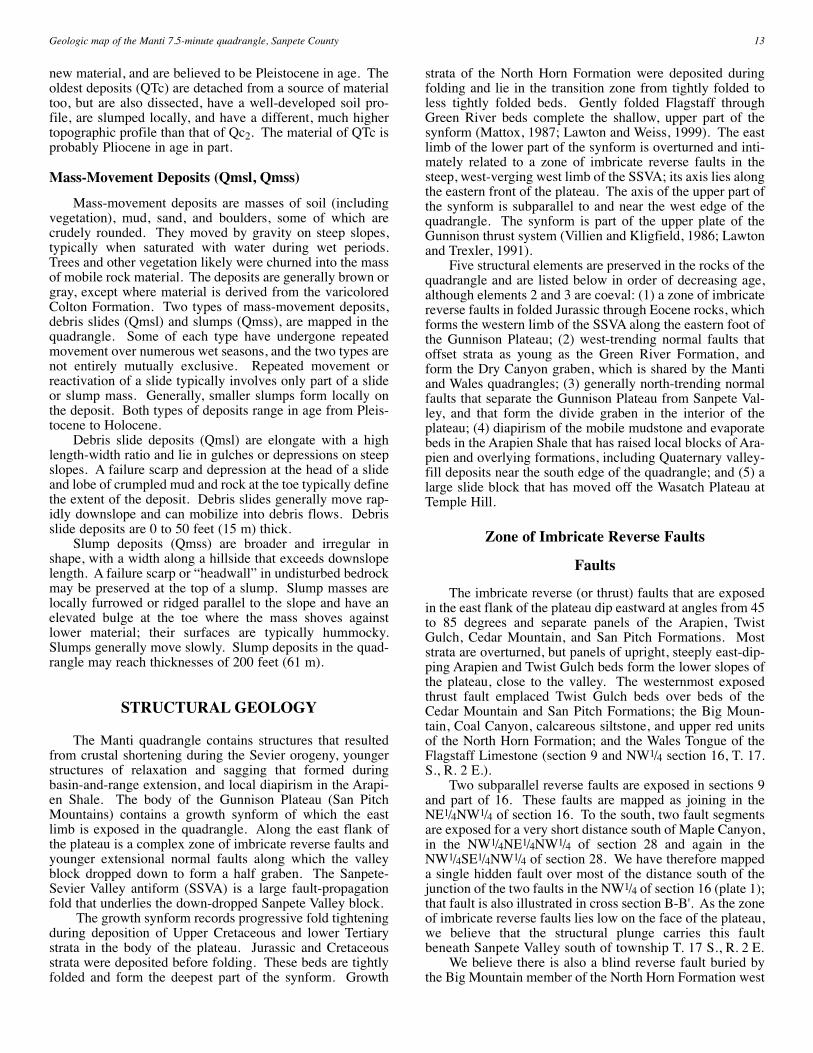
new material, and are believed to be Pleistocene in age. Theoldest deposits (QTc) are detached from a source of materialtoo, but are also dissected, have a well-developed soil pro-file, are slumped locally, and have a different, much highertopographic profile than that of Qc2. The material of QTc isprobably Pliocene in age in part.
Mass-Movement Deposits (Qmsl, Qmss)
Mass-movement deposits are masses of soil (includingvegetation), mud, sand, and boulders, some of which arecrudely rounded. They moved by gravity on steep slopes,typically when saturated with water during wet periods.Trees and other vegetation likely were churned into the massof mobile rock material. The deposits are generally brown orgray, except where material is derived from the varicoloredColton Formation. Two types of mass-movement deposits,debris slides (Qmsl) and slumps (Qmss), are mapped in thequadrangle. Some of each type have undergone repeatedmovement over numerous wet seasons, and the two types arenot entirely mutually exclusive. Repeated movement orreactivation of a slide typically involves only part of a slideor slump mass. Generally, smaller slumps form locally onthe deposit. Both types of deposits range in age from Pleis-tocene to Holocene.
Debris slide deposits (Qmsl) are elongate with a highlength-width ratio and lie in gulches or depressions on steepslopes. A failure scarp and depression at the head of a slideand lobe of crumpled mud and rock at the toe typically definethe extent of the deposit. Debris slides generally move rap-idly downslope and can mobilize into debris flows. Debrisslide deposits are 0 to 50 feet (15 m) thick.
Slump deposits (Qmss) are broader and irregular inshape, with a width along a hillside that exceeds downslopelength. A failure scarp or “headwall” in undisturbed bedrockmay be preserved at the top of a slump. Slump masses arelocally furrowed or ridged parallel to the slope and have anelevated bulge at the toe where the mass shoves againstlower material; their surfaces are typically hummocky.Slumps generally move slowly. Slump deposits in the quad-rangle may reach thicknesses of 200 feet (61 m).
STRUCTURAL GEOLOGY
The Manti quadrangle contains structures that resultedfrom crustal shortening during the Sevier orogeny, youngerstructures of relaxation and sagging that formed duringbasin-and-range extension, and local diapirism in the Arapi-en Shale. The body of the Gunnison Plateau (San PitchMountains) contains a growth synform of which the eastlimb is exposed in the quadrangle. Along the east flank ofthe plateau is a complex zone of imbricate reverse faults andyounger extensional normal faults along which the valleyblock dropped down to form a half graben. The Sanpete-Sevier Valley antiform (SSVA) is a large fault-propagationfold that underlies the down-dropped Sanpete Valley block.
The growth synform records progressive fold tighteningduring deposition of Upper Cretaceous and lower Tertiarystrata in the body of the plateau. Jurassic and Cretaceousstrata were deposited before folding. These beds are tightlyfolded and form the deepest part of the synform. Growth
strata of the North Horn Formation were deposited duringfolding and lie in the transition zone from tightly folded toless tightly folded beds. Gently folded Flagstaff throughGreen River beds complete the shallow, upper part of thesynform (Mattox, 1987; Lawton and Weiss, 1999). The eastlimb of the lower part of the synform is overturned and inti-mately related to a zone of imbricate reverse faults in thesteep, west-verging west limb of the SSVA; its axis lies alongthe eastern front of the plateau. The axis of the upper part ofthe synform is subparallel to and near the west edge of thequadrangle. The synform is part of the upper plate of theGunnison thrust system (Villien and Kligfield, 1986; Lawtonand Trexler, 1991).
Five structural elements are preserved in the rocks of thequadrangle and are listed below in order of decreasing age,although elements 2 and 3 are coeval: (1) a zone of imbricatereverse faults in folded Jurassic through Eocene rocks, whichforms the western limb of the SSVA along the eastern foot ofthe Gunnison Plateau; (2) west-trending normal faults thatoffset strata as young as the Green River Formation, andform the Dry Canyon graben, which is shared by the Mantiand Wales quadrangles; (3) generally north-trending normalfaults that separate the Gunnison Plateau from Sanpete Val-ley, and that form the divide graben in the interior of theplateau; (4) diapirism of the mobile mudstone and evaporatebeds in the Arapien Shale that has raised local blocks of Ara-pien and overlying formations, including Quaternary valley-fill deposits near the south edge of the quadrangle; and (5) alarge slide block that has moved off the Wasatch Plateau atTemple Hill.
Zone of Imbricate Reverse Faults
Faults
The imbricate reverse (or thrust) faults that are exposedin the east flank of the plateau dip eastward at angles from 45to 85 degrees and separate panels of the Arapien, TwistGulch, Cedar Mountain, and San Pitch Formations. Moststrata are overturned, but panels of upright, steeply east-dip-ping Arapien and Twist Gulch beds form the lower slopes ofthe plateau, close to the valley. The westernmost exposedthrust fault emplaced Twist Gulch beds over beds of theCedar Mountain and San Pitch Formations; the Big Moun-tain, Coal Canyon, calcareous siltstone, and upper red unitsof the North Horn Formation; and the Wales Tongue of theFlagstaff Limestone (section 9 and NW1/4 section 16, T. 17.S., R. 2 E.).
Two subparallel reverse faults are exposed in sections 9and part of 16. These faults are mapped as joining in theNE1/4NW1/4 of section 16. To the south, two fault segmentsare exposed for a very short distance south of Maple Canyon,in the NW1/4NE1/4NW1/4 of section 28 and again in theNW1/4SE1/4NW1/4 of section 28. We have therefore mappeda single hidden fault over most of the distance south of thejunction of the two faults in the NW1/4 of section 16 (plate 1);that fault is also illustrated in cross section B-B'. As the zoneof imbricate reverse faults lies low on the face of the plateau,we believe that the structural plunge carries this faultbeneath Sanpete Valley south of township T. 17 S., R. 2 E.
We believe there is also a blind reverse fault buried bythe Big Mountain member of the North Horn Formation west
13Geologic map of the Manti 7.5-minute quadrangle, Sanpete County
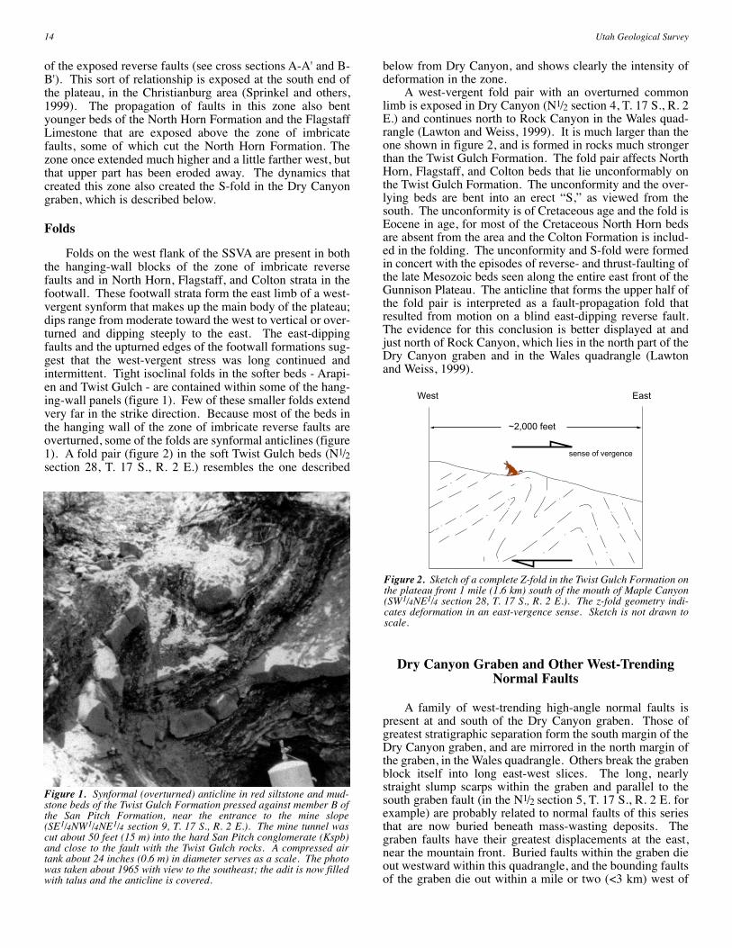
of the exposed reverse faults (see cross sections A-A' and B-B'). This sort of relationship is exposed at the south end ofthe plateau, in the Christianburg area (Sprinkel and others,1999). The propagation of faults in this zone also bentyounger beds of the North Horn Formation and the FlagstaffLimestone that are exposed above the zone of imbricatefaults, some of which cut the North Horn Formation. Thezone once extended much higher and a little farther west, butthat upper part has been eroded away. The dynamics thatcreated this zone also created the S-fold in the Dry Canyongraben, which is described below.
Folds
Folds on the west flank of the SSVA are present in boththe hanging-wall blocks of the zone of imbricate reversefaults and in North Horn, Flagstaff, and Colton strata in thefootwall. These footwall strata form the east limb of a west-vergent synform that makes up the main body of the plateau;dips range from moderate toward the west to vertical or over-turned and dipping steeply to the east. The east-dippingfaults and the upturned edges of the footwall formations sug-gest that the west-vergent stress was long continued andintermittent. Tight isoclinal folds in the softer beds - Arapi-en and Twist Gulch - are contained within some of the hang-ing-wall panels (figure 1). Few of these smaller folds extendvery far in the strike direction. Because most of the beds inthe hanging wall of the zone of imbricate reverse faults areoverturned, some of the folds are synformal anticlines (figure1). A fold pair (figure 2) in the soft Twist Gulch beds (N1/2section 28, T. 17 S., R. 2 E.) resembles the one described
below from Dry Canyon, and shows clearly the intensity ofdeformation in the zone.
A west-vergent fold pair with an overturned commonlimb is exposed in Dry Canyon (N1/2 section 4, T. 17 S., R. 2E.) and continues north to Rock Canyon in the Wales quad-rangle (Lawton and Weiss, 1999). It is much larger than theone shown in figure 2, and is formed in rocks much strongerthan the Twist Gulch Formation. The fold pair affects NorthHorn, Flagstaff, and Colton beds that lie unconformably onthe Twist Gulch Formation. The unconformity and the over-lying beds are bent into an erect “S,” as viewed from thesouth. The unconformity is of Cretaceous age and the fold isEocene in age, for most of the Cretaceous North Horn bedsare absent from the area and the Colton Formation is includ-ed in the folding. The unconformity and S-fold were formedin concert with the episodes of reverse- and thrust-faulting ofthe late Mesozoic beds seen along the entire east front of theGunnison Plateau. The anticline that forms the upper half ofthe fold pair is interpreted as a fault-propagation fold thatresulted from motion on a blind east-dipping reverse fault.The evidence for this conclusion is better displayed at andjust north of Rock Canyon, which lies in the north part of theDry Canyon graben and in the Wales quadrangle (Lawtonand Weiss, 1999).
Dry Canyon Graben and Other West-TrendingNormal Faults
A family of west-trending high-angle normal faults ispresent at and south of the Dry Canyon graben. Those ofgreatest stratigraphic separation form the south margin of theDry Canyon graben, and are mirrored in the north margin ofthe graben, in the Wales quadrangle. Others break the grabenblock itself into long east-west slices. The long, nearlystraight slump scarps within the graben and parallel to thesouth graben fault (in the N1/2 section 5, T. 17 S., R. 2 E. forexample) are probably related to normal faults of this seriesthat are now buried beneath mass-wasting deposits. Thegraben faults have their greatest displacements at the east,near the mountain front. Buried faults within the graben dieout westward within this quadrangle, and the bounding faultsof the graben die out within a mile or two (<3 km) west of
14 Utah Geological Survey
Figure 1. Synformal (overturned) anticline in red siltstone and mud-stone beds of the Twist Gulch Formation pressed against member B ofthe San Pitch Formation, near the entrance to the mine slope(SE1/4NW1/4NE1/4 section 9, T. 17 S., R. 2 E.). The mine tunnel wascut about 50 feet (15 m) into the hard San Pitch conglomerate (Kspb)and close to the fault with the Twist Gulch rocks. A compressed airtank about 24 inches (0.6 m) in diameter serves as a scale. The photowas taken about 1965 with view to the southeast; the adit is now filledwith talus and the anticline is covered.
~2,000 feet
sense of vergence
West East
Figure 2. Sketch of a complete Z-fold in the Twist Gulch Formation onthe plateau front 1 mile (1.6 km) south of the mouth of Maple Canyon(SW1/4NE1/4 section 28, T. 17 S., R. 2 E.). The z-fold geometry indi-cates deformation in an east-vergence sense. Sketch is not drawn toscale.
the Manti and Wales quadrangles. The major scarps of thegraben are in the Flagstaff Limestone, but those faults juxta-pose Green River beds against Colton beds and cut every-thing down through the Twist Gulch Formation. The strati-graphic separation on the south graben fault near the mouthof Dry Canyon is about 530 feet (162 m).
Several faults of the same orientation lie as far as 3 miles(5 km) south of the graben, and are considered to be relatedto the same north-south extension that produced the graben.Several fracture zones in the plateau top lie parallel to thegraben faults within this same distance south of the graben.The fracture zones are marked by lines of more abundantvegetation, faint lineations seen on aerial photographs, andsome springs. No displacement of strata can be observed atthese zones, but the fractures are expressed in the Colton For-mation, which contains few thick, brittle beds that might re-cord displacement.
The Dry Canyon graben is unique on the GunnisonPlateau, for it is a large structure at right angles to the lengthof the plateau and the major bounding fault that separates theplateau from Sanpete Valley. This peculiar condition is noteasily accounted for, and several unpublished hypotheses ofits origin have been proposed and abandoned. Furthermore,the North Horn, Flagstaff, and Colton Formations are anom-alously thin in the part of the Dry Canyon graben close to themountain front, in the area of the S-fold. Stratigraphic thin-ning and structural orientation have been attributed to a lat-eral ramp of the Gunnison thrust plate that extended east-west about here, at right angles to the sedimentary strike ofthe later Cretaceous and Paleocene formations, and that, dur-ing Neogene extension, moved downward to form the DryCanyon graben (Lawton and Weiss, 1999, figure 4). Themarked north-south differences in the thickness and lithofa-cies of the latest Cretaceous deposits (members of the NorthHorn Formation), the Flagstaff Limestone, and the ColtonFormation are concentrated at the latitude of the Dry Canyongraben, a fact that accords with the postulated lateral rampanticline.
North-Trending Normal Faults
Range-Front Faults
The Gunnison Plateau is separated from Sanpete Valley,along its entire eastern front, by a normal fault zone that cre-ates the topographic differential between the plateau and thevalley. The range-front fault zone was called the “valleyfault” by Fong (1995) and the “Gunnison fault” by Weiss(1982a). The height of the fault scarp (and probable amountof displacement) is greatest near the north end of the plateau.The fault scarp height decreases to zero at the south end ofthe plateau, in the Sterling quadrangle, where the rocks of theplateau plunge beneath the Quaternary deposits of SevierValley (Mattox, 1992; Weiss, 1994). The structural relief onthe range-bounding fault(s) is at least 4,400 feet (1,350 m) inthe Price N well (SE1/4SE1/4 section 29, T. 15 S., R. 3 E.),near Wales, about 7 miles (11 km) north of the Manti quad-rangle (Sprinkel, 1994). Five miles (8 km) south of theManti quadrangle the displacement is only about 300 feet (91m) (Weiss, 1994).
The range-front fault zone is not as well exposed in theManti quadrangle as it is north and south of the quadrangle,
but faults do cut Quaternary deposits (QTaf) in sections 2,15, 16, and 21, T. 17 S., R. 2 E. Low scarps of 2 to 6 feet(0.6-2 m) are present locally, are conspicuous on aerial pho-tographs, and tend to have lines of more abundant vegetationalong them. Most of the length of the fault(s) in the Mantiquadrangle is hidden by Holocene deposits and agriculturaldisturbance. Even Holocene surfaces are cut in the Walesquadrangle, where displacement of deposits of Quaternaryage on this fault system is six to eight times greater (Lawtonand Weiss, 1999); this suggests that the plateau block is stilltilting toward the south.
This range-front fault zone is subparallel to and just eastof the zone of imbricate reverse faults, and is believed tohave resulted from Neogene extension affecting that weakzone of older faults. The zone of normal faults may havereactivated on thrust surface(s), and probably merges atdepth into the thrust decollement that underlies the SanpeteValley (Standlee, 1982). The dropping of the Flagstaff,Colton, and Green River beds into the subsurface along thewest side of Sanpete Valley formed the Sanpete Valley half-graben and was an integral part of the formation of theWasatch monocline, across Sanpete Valley to the east. With-jack and others (1995) modeled features very similar to thosebeneath Sanpete Valley and low on the Wasatch monocline,except that there was no antiform in their down-faulted block(see Withjack and others, 1995, figures 2, 8, and the coloredcover of number 1 of that volume).
The Divide Graben
The Green River Formation is preserved along the crestof the plateau partly because it lies within a graben, asdescribed above. Mattox (1987) named this graben thedivide graben, and it is conspicuously developed in the HellsKitchen Canyon Southeast quadrangle, west of the Mantiquadrangle. The divide graben extends south-southeastwardfrom the western end of the Dry Canyon graben and crossesinto the Manti quadrangle just north of Antelope Valley. Thestratigraphic displacement on the main bounding faults isabout 600 feet (183 m) where it enters the Manti quadrangle(Mattox, 1987), but decreases rapidly in Antelope Valley; thegraben dies out southward in the Sterling quadrangle, mid-way down Antelope Valley (Weiss, 1994). The divide grabenis believed to have developed during Neogene extension.
Diapirism
Much has been written about the role of diapirism in theregional structural development of central Utah (Witkind,1982, 1983, 1992, 1994; Witkind and Page, 1984). Thediapiric hypothesis argues that the unconformities, faults,and folds rimming the Sanpete and Sevier Valleys, as well asthe formation of these valleys, were not the result of con-tractional deformation by the Sevier orogeny and basin-and-range extension. Instead, this hypothesis proposes that theywere caused by the vertical action of salt diapirism within theArapien Shale, followed by solution collapse (Witkind, 1982,1983, 1992, 1994; Witkind and Page, 1984). We do not sub-scribe to the hypothesis that regional salt diapirism is the solecause of the tectonic development of the area since the Cre-taceous. We believe that crustal shortening during the Sevi-er orogeny, followed by regional extension, created nearly all
15Geologic map of the Manti 7.5-minute quadrangle, Sanpete County
of the stratigraphic and structural relations in central Utah,particularly in pre-Pliocene strata. Several reasons make itclear to us that tectonic forces rather than only regionaldiapirism and salt dissolution are responsible for the majortectonic and sedimentary history of the Sanpete-Sevier Val-ley region: (1) surface and subsurface examples of majorregional deformational features caused by the Sevier oroge-ny and basin-and-range extension are well documented incentral Utah; (2) sedimentation and deformation of growthstrata are consistent with the style and timing of the Sevierorogeny; (3) overturning of fault-repeated strata and consis-tent west-vergence of faults and folds along the east flank ofthe Gunnison Plateau requires crustal shortening not predict-ed by the diapirism model; and (4) the Arapien Shale doesnot pierce the crest of the antiform in Sanpete Valley asexpected in a salt diapir, but instead crops out along the west-ern margin of the antiform in the zone of imbricate reversefaults.
However, we do believe that diapirism of the Arapienmudstone and evaporate beds as a whole contributed to localdeformation of bedrock units and poorly consolidateddeposits during late Tertiary and Quaternary time. Localdiapirism of the Arapien Shale has modified structures atseveral places in both Sanpete and Sevier Valleys (Willis,1986; Weiss, 1994). In the Manti quadrangle, we believelocal diapirism is expressed by the Arapien Shale exposednear the south edge (NW1/4 section 15, T. 18 S., R. 2 E.) andby the uplifted and tilted (as much as 50° west) old valley-filldeposits (QTal) that form the river knolls. Effects of localdiapirism are also described along this trend of uplifted Ara-pien Shale to the south into the Sterling quadrangle, where itis more conspicuous (Weiss, 1994). Significantly, thesemanifestations of local diapirism are preserved (here and inthe Sterling quadrangle) where Sanpete Valley is narrowest,where the masses of the Gunnison and Wasatch Plateausappear to be jammed together.
Temple Hill Toreva Block
Temple Hill is at the north edge of the city of Manti, inthe southeastern quadrant of the quadrangle; most of TempleHill lies in the adjacent Ephraim quadrangle. On Temple Hillstands the lovely Victorian Manti Temple, built of oolitic andostracodal limestone from the upper member of the GreenRiver Formation, which crops out in, and was quarried from,the hill on which the temple stands. The western part ofTemple Hill is a northwest-dipping cuesta of upper GreenRiver limestone and salt-and-pepper sandstone of the overly-ing Crazy Hollow Formation. The cuesta is one of a seriesthat extends northward, intermittently, for about 40 miles (64km) along the east side of Sanpete Valley, at the toe of theWasatch Plateau.
The structure in the whole hill is more complicated thana simple cuesta. The higher and eastern part of the hill isformed by a synclinal mass of lower Green River, upperGreen River, and Crazy Hollow beds that lie above the north-west-dipping cuestiform Green River and Crazy Hollow bedsin the western part of the hill. The section from the upperpart of the lower Green River mudstones through the CrazyHollow beds is thus repeated in the hill. The synclinal upperblock lies above a slide surface between the repeated sec-tions. That surface is not a tectonic thrust surface, but rather
a surface along which a large block of Green River and CrazyHollow beds slid off the Wasatch monocline (a west-dippingflexure along the west flank of the Wasatch Plateau that iseast of the Manti quadrangle), bent into a synclinal mass, andcame to rest on a cuesta of Green River and Crazy Hollowrocks. The slide block is unusual in that it remained coher-ent during the movement, and its strata are not much dis-turbed - it is a toreva block in the classic sense. We noticedthat a normal fault does cut the synclinal mass on the north-east, outside this quadrangle.
We believe the slide block extends northwestward fromTemple Hill into the subsurface, for it is present in the Mad-sen 7-25 well (table 1; section B-B'). Dip meter and otherpetrophysical log interpretations suggest that a slab of dis-placed Green River beds, 474 feet (145 m) thick, rests onnorthwest-dipping Green River beds in the well. The slidesurface probably has the shape of a shallow spoon plungingnorthwestward from Temple Hill. The aspect shown in sec-tion B-B' is somewhat artificial because the well record hasbeen projected into the line of section from its site northwestof Temple Hill.
Other slides, both smaller and larger, where soft Coltonand Green River beds have slid or slumped off the Wasatchmonocline, lie along the east side of Sanpete Valley. Onlythe synclinal block on Temple Hill is a coherent toreva block;the others are all churned up. Temple Hill and the otherslides outside of the Manti quadrangle are considered to haveformed during wetter intervals in the Pleistocene, when theColton and Green River mudstone beds on the flank of themonocline were so weak and heavy that they could not sup-port themselves on the monoclinal slope (Weiss, 1994).Thus, the Temple Hill toreva block is a rather late feature, ofPleistocene (probably Wisconsinan) age.
Origin and Timing of Structural Deformation
Reverse Faulting and Folding
The folded and faulted strata of the east front of theGunnison Plateau are part of the imbricated forelimb of alarge, west-directed fault-propagation fold that was cut bysubsequent normal faulting. The fold is the Sanpete-SevierValley antiform (SSVA) (Sanpete-Sevier Valley anticline ofGilliland, 1963). The fold arose as a back-thrusted fold onthe upper plate of the Gunnison thrust (Standlee, 1982; Law-ton, 1985; Lawton and Weiss, 1999). The evidence for theinitial growth of the fold in Campanian time is found in theWales quadrangle (Lawton and Weiss, 1999), where theNorth Horn Formation is much thicker and offers numerousmembers from which to diagnose the sedimentary story. Bycontrast, elements of the formation exposed in the Mantiquadrangle are fewer and much reduced in thickness.
The antiform rose and pressed westward episodicallyover a long interval of time - into the Eocene. For example,the great lens of redbeds (Tnu) between the Wales Tongueand the main body of the Flagstaff Limestone suggests arenewal of elevation of the west limb of the SSVA and theconcomitant release of a new flood of red sediment from theJurassic beds in the zone of imbricate reverse faults. Most ofthe structural relief was probably developed during Campan-ian time (Lawton, 1985; Lawton and Weiss, 1999). Duringdeposition of the Coal Canyon member of the North Horn
16 Utah Geological Survey
Formation the prevailing regional eastward transport of sed-iment was reversed; for a time the SSVA was itself a sourcethat yielded earlier-deposited sediment back westward into apiggyback basin (Lawton and Weiss, 1999). The final bend-ing of the S-fold in the Dry Canyon graben records post-earlyEocene deformation in the same belt, for it affects beds asyoung as the lower part of the Colton Formation.
Rocks of Mesozoic age (Arapien through North HornFormations) in and under the Gunnison Plateau and underly-ing the Sanpete Valley are part of the upper plate of the Gun-nison thrust, which moved eastward during the Sevier oroge-ny (Standlee, 1982; Lawton, 1985; Lawton and Weiss, 1999).The leading edge of the upper plate lies under eastern San-pete Valley, and the SSVA resulted from a back thrust thatdeveloped near the edge of the plate and raised the youngerMesozoic rocks into the SSVA (Lawton and Weiss, 1999, fig-ure 3). As the antiform rose and tightened east-west, its westlimb was overturned westward, so that beds of the west limbsheared upward and westward in what is recognized today asthe zone of imbricate reverse faults. Subsidiary folds in thatwest limb tightened and sheared, such that some of the bedsexposed in the zone today are overturned and others areupright. The structural and stratigraphic relationships areshown in cross-sections A-A' and B-B'. The vertical dis-placement of Jurassic beds, which are now at the surface,exceeds 10,000 feet (3,050 m) (Lawton and Weiss, 1999).
East-Trending Normal Faults
East-trending normal faults, including those flanking theDry Canyon graben, resulted from early basin-and-rangeextension, probably in the Miocene epoch. They are post-Eocene, for they cut the Colton and Green River Formationseverywhere. They may have resulted from relaxation of anolder contractional structure; a lateral ramp in the hangingwall of the Gunnison thrust plate (Lawton and Weiss, 1999,figure 4). Evidence for this scheme is the thin North Horn-Colton section in the graben, contrasted with thicker sectionsnorth and south of the graben. Transport of hanging-wallrocks oblique to the trend of the ramp in the footwall of theGunnison thrust created an east-west anticline during deposi-tion of the North Horn. Subsequent extension permitted nor-mal faulting along the trend of that footwall ramp. The gra-ben is cut on the east by the range-bounding fault system, ofcourse. That was subsequent to the development of the gra-ben, but may have been very soon after the formation of thegraben, for the range-bounding fault system is owed to thesame basin-and-range extension episode.
North-Trending Normal Faults
North-trending normal faults define the plateau/valleyboundary and also the divide graben. When they began is notevident from the rocks of the quadrangle, but basin-and-range extension in the Miocene probably initiated thesefaults. They have moved repeatedly since then and continueto do so, as shown by the scarps in the consolidated alluvialfans (QTaf). In the Wales quadrangle the range-boundingfault(s) cut the youngest Holocene fan deposits (Lawton andWeiss, 1999). The possible influence of the range-front faultzone on the formation of the Wasatch monocline is notknown; the two may have been integral parts of the samedynamic couple.
ECONOMIC GEOLOGY
The main earth resources sought or produced within theManti quadrangle are sand and gravel, limestone, and petro-leum. Prospecting for metallic minerals has also beenattempted.
Sand and Gravel
The younger alluvial-fan deposits and, locally, the oldervalley-fill materials have been quarried for road metal andconstruction fill. The principal sources have been the MapleCanyon fan and the River Knoll on the county road west ofManti. The gravels are very poorly sorted and contain muchsand; boulders from the debris-flow deposits on the MapleCanyon fan are also conspicuous. The pebbles and largerclasts are mostly of carbonates from the Flagstaff Limestoneand the finer particles are mostly quartz sand from the NorthHorn and Colton Formations. See also Pratt and Callaghan(1970) and Utah Department of Highways (1966) for infor-mation on the sand and gravel deposits in the Manti quad-rangle.
Limestone
Dimension stone from the smooth, even ledges of theupper member of the Green River Formation was formerlyproduced in large quantities from the part of Temple Hilllying in the Ephraim quadrangle. The rock was used first forthe Manti Temple and later for many residential and otherbuildings in Manti. The quarries have lain unused since thedepression of the 1930s. Temple Hill is a part of the monu-mental architecture that stands on it and cannot again supporta major quarry industry. However, some rock was removedin the late 1990s for repair of the east face of the Manti Tem-ple.
A lime kiln for the production of lime mortar was builtand operated in pioneer days in Dodge Canyon, in theSW1/4NE1/4 section 5, T. 18 S., R. 2 E. Lumps of fused rock,firebrick, and remnants of the kiln walls are still present. Asmall prospect pit, perhaps for the same purpose, was duglow on the plateau face in the SE1/4NW1/4 of section 4.Abundant limestone suitable for aggregate lies in theFlagstaff and Green River Formations on the GunnisonPlateau, but difficult access hinders development of thesedeposits.
Petroleum
Although no petroleum or natural gas has been econom-ically produced in Sanpete County, exploration for theseresources has been intermittently vigorous. Sanpete Valleyhas experienced two intervals of petroleum exploration: inthe late 1950s, and again in the 1970s and early 1980s. Dur-ing the 1950s cycle, companies drilled the SSVA. From thateffort, gas was reportedly recovered on a drill stem test fromthe Cretaceous Funk Valley Formation (Ferron Sandstoneequivalent) in the Tennessee Oil & Gas Transmission Irons#1 (NE1/4SE1/4 section 16, T. 15 S., R. 3 E., Wales quadran-gle), but no commercial production resulted. Explorationintensified in the 1970s when companies, inspired by better
17Geologic map of the Manti 7.5-minute quadrangle, Sanpete County
seismic reflection data and shows of oil in wells, againdrilled the SSVA. During this period the Hanson Oil Com-pany drilled the Moroni 1AX (SE1/4NE1/4 section 14, T. 14S., R. 3 E., Wales quadrangle), and recovered oil from theCretaceous Allen Valley Shale (Tununk Shale equivalent).Hanson attempted for several months to establish commer-cial production, but the well was eventually abandoned.
Four wells, two Mobil wells and two Chandler wells,were drilled in the Manti quadrangle (table 1) during the latercycle. All four wells were drilled near the crest of the SSVAor along its steeply dipping east limb. The Mobil Larson #1well (table 1) was drilled to test the deeper parts of the SSVAstructure. Surprisingly, the well drilled through significantoil shows in the Cretaceous Funk Valley Formation in theshallow part of the hole. To test those shows while continu-ing to drill to the primary objective, Mobil brought in a sec-ond rig and drilled the Larson #2 through the stratigraphicinterval that contained the oil shows. Mobil performed com-pletion tests on the interval for several weeks and eventuallyabandoned the well. The Larson #1 was also abandoned afterdrilling more than 6,000 feet (1,829 m) of Jurassic ArapienShale.
Interest in discovering petroleum in the Cretaceous stra-ta along the east limb of the SSVA continued in the 1990s.This activity is within the Wales quadrangle, and was anattempt to evaluate the oil shows in the Hanson Moroni 1AXwell. To date, the efforts have produced sub-economic quan-tities of oil. The source of the oil that was recovered from theCretaceous reservoirs in Sanpete Valley is probably the AllenValley Shale (Tununk equivalent). Geochemical analysisindicates that the oil and gas produced from Cretaceousreservoirs under the Wasatch Plateau fields, about 15 miles(24 km) northeast of the Sanpete Valley, is from organic-richbeds in the Cretaceous (Sprinkel and others, 1997). In addi-tion, unpublished geochemical analyses indicate that the oilrecovered from the Hanson Moroni 1AX well is geochemi-cally similar to the Cretaceous oil and gas from the WasatchPlateau fields. The study by Sprinkel and others (1997) alsoanalyzed outcrop samples of the Allen Valley Shale, theTununk Shale, the Blue Gate Shale, and the Blackhawk For-mation for organic richness and other source-rock character-istics. They found that the Allen Valley and Tununk Shaleswere lean compared to the Blue Gate Shale and the Black-hawk Formation (Sprinkel and others, 1997). Unfortunately,the Allen Valley Shale is the only organic-rich mudstone ofCretaceous age drilled in the Moroni 1AX well; the FunkValley Formation there contains few mudstone beds and theoverlying Sixmile Canyon Formation (Blue Gate Shaleequivalent) contains none. The organic-rich facies of theFerron, Blue Gate, and Blackhawk are east of the SanpeteValley and under the Wasatch Plateau, which is structurallyhigher than their equivalent beds in Sanpete Valley. The poorproduction performance from the Cretaceous in Sanpete Val-ley may be in part due to the poor source quality of the AllenValley Shale (Tununk Shale equivalent). Both these factorsprobably limit the petroleum potential for Cretaceous targetsin the Manti quadrangle.
Other targets that may have petroleum potential in theManti quadrangle are likely restricted to Permian or Missis-sippian reservoirs associated with the SSVA, at depths gen-erally greater than 18,000 feet (5,486 m) (Sprinkel and oth-ers, 1995). The source of oil and gas for those reservoirs is
thought to be the organic-rich mudstone beds in the PermianToroweap Formation (Sprinkel and others, 1997), but nowells have been drilled through the Toroweap in the SanpeteValley to confirm that potential source beds are present in thearea.
Metals
No metals have been produced from the Manti area, butsome valiant attempts have been made to obtain them. Aditsand short tunnels were dug in several places. Such workingsare found along the thrust-fault surface in the SE1/4NW1/4section 16, T. 17 S., R. 2 E., north of Maple Canyon, but themetal sought is not known. Two tunnels were dug into thelowest Twist Gulch beds in SE1/4NW1/4NE1/4 section 9, T. 17S., R. 2 E., for copper, during World War I. A sloping tunnelabout 50 feet (15 m) long was cut into the cemented con-glomerate of member B of the San Pitch Formation, justbeneath the Twist Gulch beds (figure 1), in the northwest cor-ner of the SW1/4SE1/4 section 4, T. 17 S., R. 2 E. It is notknown when it was started, but the tunnel was lengthenedintermittently during the late 1950s and early 1960s. Theobjective was silver according to local residents of SanpeteValley.
WATER RESOURCES
The most valuable natural resource in the Manti quad-rangle is water, both surface and subsurface. Dry Creek,ironically, is one of only three perennial streams on the entireeast face of the Gunnison Plateau. Manti Creek dischargesabundant surface water from high on the Wasatch Plateauand supplies the city of Manti with irrigation and drinkingwater. The course of the San Pitch River is mostly channel-ized above the choke point at the River Knoll, and the riverforms a vast shallow lake in the valley during wet years. Dry,Maple, and Dodge Canyons discharge large volumes ofwater and sediment during storms and snowmelt. All ofthese sources combine to recharge the valley-marginal fansand the central-valley fill with subsurface water.
The water table in the valley center is generally less than30 feet (9 m) below the surface and the interbedding of per-meable with impermeable layers produces both confined andunconfined aquifers (Robinson, 1971). The water table isgreater than 30 feet (9 m) below the surface along the valleymargins, especially along the base of the Wasatch Plateau(Robinson, 1971). A number of flowing wells provide waterfor stock and irrigation for Sanpete Valley.
GEOLOGIC HAZARDS
Three types of hazards are enduring threats to people,livestock, and cultural installations in the Manti quadrangle.In decreasing order of frequency, they are floods, landslides,and earthquakes. Floods and the accompanying debris flowsfrom the larger canyons are an almost annual threat. Fortu-nately, the area of the quadrangle is given over almost entire-ly to forestry and agricultural uses that are less sensitive toflood damage. A debris flow on the Maple Canyon fan(Qmf1) occurred in August of 1965, during a particularly wetyear, but the road was restored across it within days. The city
18 Utah Geological Survey
of Manti suffered a severe scare and some damage during therecord wet years of 1983-84, but the stream has incisedenough into the fan on which Manti is built to contain mostflood debris. The periodic flooding of the central and north-ern portions of Sanpete Valley is an inconvenience to ownerswho own grazing rights, but is an important replenishment ofthe ground-water supply.
Landsliding and slumping are constant threats on thesteep slopes of the plateau escarpment and on canyon walls.Slope failures are hastened during snowmelt and in wetyears, and affect particularly the soft mudstone units of theNorth Horn and Colton Formations, and the lower shalemember of the Green River Formation. The Arapien andTwist Gulch Formations are also susceptible to slope fail-ures, but the hazard is less significant than in other failure-prone units because these areas are generally small and formmore gentle slopes. Mountain roads are the most commonlyimpacted cultural features by landslides and slumps in theManti quadrangle.
Seismic activity along the range-front fault zone andother active faults in the area is a potential source of earth-quakes in the Manti quadrangle. Subdued scarps in Quater-nary deposits in the quadrangle show that geologically recentmovement has occurred and therefore surface-rupturingearthquakes are likely to recur. The most recent event, withprobable displacement of less than 3 feet (1 m) in the Walesquadrangle, may have taken place in late Holocene time(Hecker, 1993). Paleoseismic data are needed to more accu-rately date the most recent surface-rupturing earthquakeevent and evaluate the recurrence interval for future surface-
rupturing earthquakes. Generally, citizens of central Utahhave only felt a few earthquakes. Of the historic earth-quakes, most are small-to-moderate in strength and general-ly have occurred in Sevier Valley, south than Manti. Impactsfrom earthquakes include ground shaking, and possibly liq-uefaction of saturated alluvial deposits along the San PitchRiver that could disrupt irrigation ditches and weirs. Thefeatures at most risk are masonry buildings in the city ofManti, which is built on an alluvial fan made of uncementedsediments.
ACKNOWLEDGMENTS
We particularly appreciate the continuing counsel ofTimothy F. Lawton (New Mexico State University), both inthe field and in the office. His knowledge of sedimentaryfeatures and structures has been critical to the current under-standing of the North Horn Formation. We also thank Timfor his review of the map and manuscript. His comments sig-nificantly improved the quality of the map and the clarity andreadability of the manuscript. We thank Robert F. Biek, San-dra N. Eldredge, Richard E. Giraud, Michael D. Hylland,David E. Tabet, Janae Wallace, and Grant C. Willis (all of theUtah Geological Survey) for their careful review. Mr.Richard Nielsen, of Ephraim, very kindly permitted us toramble over the mountain front between Dry and MapleCanyons. Weiss owes an enduring debt to students and staffof the Ohio State University Geology Field Station forknowledge gained and companionship in the field.
19Geologic map of the Manti 7.5-minute quadrangle, Sanpete County
Auby, W.L., 1991, Provisional geologic map of the Levan quad-rangle, Juab County, Utah: Utah Geological Survey Map135, 13 p., scale 1:24,000.
Babisak, Julius, 1949, The geology of the southeastern portionof the Gunnison Plateau, Utah: Columbus, The Ohio StateUniversity, M.S. thesis, 97 p.
Banks, R.L., 1991, Provisional geologic map of the FountainGreen North quadrangle, Sanpete and Juab Counties, Utah:Utah Geological Survey Map 134, 21 p., scale 1:24,000.
Biek, R.F., 1991, Provisional geologic map of the Nephi quad-rangle, Juab County, Utah: Utah Geological Survey Map137, 21 p., scale 1:24,000.
Birsa, D.S., 1973, The North Horn Formation, central Utah -Sedimentary facies and petrography: Columbus, The OhioState University, M.S. thesis, 189 p., scale 1:24,000.
Bryant, Bruce, Naeser, C.W., Marvin, R.F., and Mehnert, H.H.,1989, Upper Cretaceous and Paleogene sedimentary rocksand isotopic ages of Paleogene tuffs, Uinta Basin, Utah:U.S. Geological Survey Bulletin 1787-J, 22 p.
Craig, L.C., 1981, Lower Cretaceous rocks, southeastern Utahand southwestern Colorado, in Wiegand, G.L., editor, Geol-ogy of the Paradox Basin: Rocky Mountain Association ofGeologists, p. 195-200.
Dickinson, W.R., Lawton, T.F., and Inman, K.F., 1986, Sand-stone detrital modes, central Utah foreland - stratigraphicrecord of Cretaceous-Paleogene tectonic evolution: Journalof Sedimentary Petrology, v. 56, p. 276-293.
Fong, A.W., 1995, Geologic map of the Fountain Green Southquadrangle, Sanpete and Juab Counties, Utah: Utah Geo-logical Survey Miscellaneous Publication MP-95-1, 18 p.,scale 1:24,000.
Fouch, T.D., Lawton, T.F., Nichols, D.J., Cashion, W.B., andCobban, W.A., 1983, Patterns and timing of synorogenicsedimentation in Upper Cretaceous rocks of central andnortheast Utah, in Reynolds, M.W., and Dolly, E.D., edi-tors, Mesozoic paleogeography of west-central UnitedStates, Symposium 2: Society of Economic Paleontologistsand Mineralogists, Rocky Mountain Section, p. 305-336.
Gilliland, W.N., 1963, Sanpete-Sevier Valley anticline of centralUtah: Geological Society of America Bulletin, v. 74, p. 115-124.
Gundersen, W.C., and Gilliland, W.N., 1967, Stratigraphicreflections of the Sanpete-Sevier Valley anticline of centralUtah: Transactions, New York Academy of Sciences, series2, v. 29, p. 686-699.
Hardy, C.T., 1952, Eastern Sevier Valley, Sevier and SanpeteCounties, Utah, with reference to formations of Jurassicage: Utah Geological and Mineralogical Survey Bulletin43, 98 p.
Hardy, C.T., and Zeller, H.D., 1953, Geology of the west-centralpart of the Gunnison Plateau: Geological Society of Amer-ica Bulletin, v. 64, no. 11, p. 1,261-1,278.
Hecker, Suzanne, 1993, Quaternary tectonics of Utah withemphasis on earthquake-hazard characterization: UtahGeological Survey Bulletin 127, 157 p., scale 1:500,000.
Hobbs, R.S., 1989, The physical and magnetic polarity stratig-raphy of the Upper Cretaceous-lower Tertiary North Hornand Flagstaff Formations, Gunnison Plateau, central Utah:Los Angeles, University of Southern California, M.S. the-sis, 162 p.
Hunt, R.E., 1950, The geology of the northern part of the Gun-
nison Plateau, Utah: Columbus, The Ohio State University,Ph.D. dissertation, 267 p.
Imlay, R.W., 1980, Jurassic paleobiogeography of the contermi-nous United States in its continental setting: U.S. Geologi-cal Survey Professional Paper 1062, 134 p.
Jacobson, S.R., and Nichols, D.J., 1982, Palynological dating ofsyntectonic units in the Utah-Wyoming thrust belt - theEvanston Formation, Echo Canyon Conglomerate and Lit-tle Muddy Creek Conglomerate, in Powers, R.B., editor,Geologic studies of the Cordilleran thrust belt: Denver,Rocky Mountain Association of Geologists, p. 735-750.
Katherman, V.E., 1949, The Flagstaff Limestone on the eastfront of the Gunnison Plateau, central Utah: Columbus, TheOhio State University, M.S. thesis, 81 p.
Katich, P.J., Jr., 1951, Recent evidence for Lower Cretaceousdeposits in the Colorado Plateau: American Association ofPetroleum Geologists Bulletin, v. 35, no. 9, p. 2,093-2,094.
—1956, Some notes on the Cretaceous faunas of eastern Utahand western Colorado, in Peterson, J.A., editor, Geologyand economic deposits of east-central Utah: IntermountainAssociation of Petroleum Geologists, 7th Annual FieldConference Guidebook, p. 106-119.
Kirkland, J.I., Britt, B.B., Burge, D.L., Carpenter, Kenneth,Cifelli, R.L., DeCourten, F.L., Eaton, J.G., Hasiotis,Stephen, and Lawton, T.F., 1997, Lower to Middle Creta-ceous dinosaur faunas of the central Colorado Plateau - akey to understanding 35 million years of tectonics, sedi-mentology, evolution and biogeography: Brigham YoungUniversity Geology Studies, v. 42, part II, p. 69-103.
Kirkland, J.I., Cifelli, R.L., Britt, B.B., Burge, D.L., DeCourten,F.L., Eaton, J.G., and Parrish, J.M., 1999, Distribution ofvertebrate faunas in the Cedar Mountain Formation, east-central Utah, in Gillette, D.D., editor, Vertebrate paleontol-ogy in Utah: Utah Geological Survey Miscellaneous Publi-cation 99-1, p. 201-217.
La Rocque, Aurèle, 1960, Molluscan faunas of the FlagstaffFormation of central Utah: Geological Society of AmericaMemoir 78, 100 p.
Lawton, T.F., 1982, Lithofacies correlations within the UpperCretaceous Indianola Group, central Utah, in Nielson, D.L.,editor, Overthrust belt of Utah: Utah Geological Associa-tion Publication 10, p. 199-213.
—1985, Style and timing of frontal structures, thrust belt, cen-tral Utah: American Association of Petroleum GeologistsBulletin, v. 69, p. 1,145-1,159.
Lawton, T.F., Talling, P.A., Hobbs, R.S., Trexler, J.H., Jr., Weiss,M.P., and Burbank, D.W., 1993, Structure and stratigraphyof Upper Cretaceous and Paleogene strata (North Horn For-mation), eastern San Pitch Mountains, Utah: Sedimentationat the front of the Sevier orogenic belt: U. S. GeologicalSurvey Bulletin 1787-II, 33 p.
Lawton, T.F., and Trexler, J.H., Jr., 1991, Piggyback basin in theSevier orogenic belt, Utah - implications for developmentof the thrust wedge: Geology, v. 19, no. 5, p. 827-830.
Lawton, T.F., and Weiss, M.P., 1999, Geologic map of the Walesquadrangle, Juab and Sanpete Counties, Utah: Utah Geo-logical Survey Miscellaneous Publication 99-2, 29 p., scale1:24,000.
Lawton, T.F., and Willis, G.C., 1987, The geology of SalinaCanyon, Utah: Geological Society of America CentennialField Guide - Rocky Mountain Section, p. 265-268.
Marcantel, E.L., and Weiss, M.P., 1968, Colton Formation (Eo-
20 Utah Geological Survey
REFERENCES
cene: fluviatile) and associated lacustrine beds, GunnisonPlateau, central Utah: Ohio Journal of Science, v. 68, p. 40-49.
Mattox, S.R., 1987, Provisional geologic map of the HellsKitchen Canyon Southeast quadrangle, Sanpete County,Utah: Utah Geological and Mineral Survey Map 98, 17 p.,scale 1:24,000.
—1992, Provisional geologic map of the Gunnison quadrangle,Sanpete County, Utah: Utah Geological Survey Map 139,11 p., scale 1:24,000.
Mattox, S.R., and Weiss, M.P., 1989, Stratigraphic relations ofthe Eocene Green River and Crazy Hollow Formations,central Utah [abs.]: Geological Society of AmericaAbstracts with Programs, v. 21, no. 5, p. 113.
Millen, T.M., 1982, Stratigraphy and petrology of the GreenRiver Formation (Eocene), Gunnison Plateau, central Utah:DeKalb, Northern Illinois University, M.S. thesis, 220 p.
Norton, K.L., 1986, Lithofacies and paleogeography of theCrazy Hollow Formation, central Utah: DeKalb, NorthernIllinois University, M.S. thesis, 183 p.
Platt, N.H., and Wright, V.P., 1992, Palustrine carbonates andthe Florida Everglades - towards an exposure index for thefresh-water environment?: Journal of Sedimentary Petrolo-gy, v. 62, p. 1,058-1,071.
Pratt, A.R., and Callaghan, Eugene, 1970, Land and mineralresources of Sanpete County, Utah: Utah Geological andMineral Survey Bulletin 85, 69 p.
Rich, T. H.V., and Collinson, J. W., 1973, First mammalian fos-sil from the Flagstaff Limestone, central Utah–Vulpavisaustralis (Carnivora: Miacidae): Journal of Paleontology,v. 47, p. 854-860.
Robinson, G.B., Jr., 1971, Ground-water hydrology of the SanPitch River drainage basin, Sanpete County, Utah: U.S.Geological Survey Water-Supply Paper 1896, 80 p.
Roche, M.G., 1985, Morrison(?) Formation of central Utahreassigned: DeKalb, Northern Illinois University, M.S. the-sis, 176 p.
Schwans, Peter, 1988a, Depositional response of Pigeon CreekFormation, Utah, to initial fold-thrust deformation in a dif-ferentially subsiding foreland basin, in Schmidt, C.J., andPerry, W.J., editors, Interaction of the Rocky Mountainforeland and the Cordilleran thrust belt: Geological Societyof America Memoir 171, p. 531-556.
—1988b, Stratal packages at the subsiding margin of the Creta-ceous foreland basin: Columbus, The Ohio State Universi-ty, Ph.D. dissertation, 2 volumes, 447 p.
—1995, Controls on sequence stacking and fluvial shallow-marine architecture in a foreland basin, in Van Wagoner,J.C., and Bertram, G.T., editors, Sequence stratigraphy offoreland basin deposits: American Association of Petrole-um Geologists Memoir 64, p. 55-102.
Sheliga, C.M., 1980, Sedimentology of the Eocene Green RiverFormation in Sevier and Sanpete Counties, central Utah:Columbus, The Ohio State University, M.S. thesis, 166 p.
Spieker, E.M., 1946, Late Mesozoic and early Cenozoic historyof central Utah: U.S. Geological Survey Professional Paper205-D, p. 117-161.
—1949a, The transition between the Colorado Plateaus and theGreat Basin in central Utah: Utah Geological Society,Guidebook to the Geology of Utah, No. 4, 106 p., scaleapproximately 1:125,000.
—1949b, Sedimentary facies and associated diastrophism in theUpper Cretaceous of central and eastern Utah: GeologicalSociety of America Memoir 39, p. 55-81.
Sprinkel, D.A., 1994, Stratigraphic and time-stratigraphic crosssections – a north-south transect from near the UintaMountain axis across the Basin and Range transition zoneto the western margin of the San Rafael Swell, Utah: U.S.Geological Survey Miscellaneous Investigations SeriesMap I-2184-D, 31 p.
Sprinkel, D.A., Castaño, J.R., and Roth, G.W., 1997, Emergingplays in central Utah based on regional geochemical, struc-tural, and stratigraphic evaluation [abs.]: Dallas, AmericanAssociation of Petroleum Geologists Annual Meeting Pro-gram, v. 6, p. A110.
Sprinkel, D.A., Lawton, T.F., and Weiss, M.P., 1995, Structuralgeometry and petroleum potential of the Sanpete-SevierValley antiform, central Utah thrust belt [abs.]: Reno,Nevada, American Association of Petroleum Geologists,Rocky Mountain Section, Official Meeting Program, p. A55.
Sprinkel, D.A., Weiss, M.P., Fleming, R.W., and Waanders,G.L., 1999, Redefining the Lower Cretaceous stratigraphywithin the central Utah foreland basin: Utah GeologicalSurvey Special Study 97, 21 p.
Standlee, L.A., 1982, Structure and stratigraphy of Jurassicrocks in central Utah - their influence on tectonic develop-ment of the Cordilleran foreland thrust belt, in Powers,R.B., editor, Geologic studies of the Cordilleran thrust belt:Rocky Mountain Association of Geologists, p. 357-382.
Stanley, K.O., and Collinson, J.W., 1979, Depositional historyof Paleocene-lower Eocene Flagstaff Limestone and coevalrocks, central Utah: American Association of PetroleumGeologists Bulletin, v. 63, p. 311-323.
Stokes, W.L., 1944, Morrison and related deposits in and adja-cent to the Colorado Plateau: Geological Society of Ameri-ca Bulletin, v. 55, p. 957-992.
—1952, Lower Cretaceous in Colorado Plateau: AmericanAssociation of Petroleum Geologists Bulletin, v. 36, p.1,766-1,776.
—1972, Stratigraphic problems of the Triassic and Jurassic sed-imentary rocks of central Utah, in Baer, J.L., and Callag-han, Eugene, editors, Plateau-Basin and Range transitionzone: Utah Geological Association Publication 2, p. 21-28.
Talling, P.J., Burbank, D.W., Lawton, T.F., Hobbs, R.S., andLund, S.P., 1994, Magnetostratigraphic chronology of Cre-taceous-to-Eocene thrust belt evolution, central Utah, USA:Journal of Geology, v. 102, p. 181-196.
Talling, P.J., Lawton, T.F., Burbank, D.W., and Hobbs, R.S.,1995, Evolution of latest Cretaceous-Eocene nonmarinedeposystems in the Axhandle piggyback basin of centralUtah: Geological Society of America Bulletin, v. 107, p.297-315.
Tschudy, R.H., Tschudy, B.D., and Craig, L.C., 1984, Palyno-logical evaluation of Cedar Mountain and Burro Canyonformations, Colorado Plateau: U.S. Geological Survey Pro-fessional Paper 1281, 24 p.
Utah Department of Highways, 1966, Material inventory, San-pete and Sevier Counties: Utah Department of HighwaysMaterials and Research Division, Materials Inventory Sec-tion, 22 p.
Villien, Alain, and Kligfield, R.M., 1986, Thrusting and synoro-genic sedimentation in central Utah, in Peterson, J.A., edi-tor, Paleotectonics and sedimentation in the Rocky Moun-tain region: American Association of Petroleum GeologistsMemoir 41, p. 281-306.
Volkert, D.G., 1980, Stratigraphy and petrology of the ColtonFormation (Eocene), Gunnison Plateau, central Utah:DeKalb, Northern Illinois University, M.S. thesis, 132 p.
21Geologic map of the Manti 7.5-minute quadrangle, Sanpete County
Weiss, M.P., 1969, Oncolites, paleoecology, and Laramide tec-tonics, central Utah: American Association of PetroleumGeologists Bulletin, v. 52, p. 1,105-1,120.
—1982a, Structural variety on the east front of the GunnisonPlateau, central Utah, in Nielson, D.L., editor, Overthrustbelt of Utah: Utah Geological Association Publication 10,p. 49-63.
—1982b, Relation of the Crazy Hollow Formation to the GreenRiver Formation, central Utah, in Nielson, D.L., editor,Overthrust belt of Utah: Utah Geological Association Pub-lication 10, p. 285-289.
—1994, Geologic map of the Sterling quadrangle, SanpeteCounty, Utah: Utah Geological Survey Map 159, 26 p.,scale 1:24,000.
—2001, The Crazy Hollow Formation (Eocene) of central Utah:Brigham Young University Geology Studies, vol. 46, p.143-161.
Weiss, M.P., and Roche, M.G., 1988, The Cedar Mountain For-mation (Lower Cretaceous) in the Gunnison Plateau, cen-tral Utah, in Schmidt, C.J., and Perry, W.J., editors, Interac-tion of the Rocky Mountain foreland and the Cordilleranthrust belt: Geological Society of America Memoir 171, p.557-569.
Weiss, M.P., McDermott, J.G. Sprinkel, D.A., Banks, R.L., andBiek, R.F., in press, Geologic map of the Chriss Canyonquadrangle: Utah Geological Survey Map 185, 27 p., scale1:24,000.
Willis, G.C., 1986, Geologic map of the Salina quadrangle,Sevier County, Utah: Utah Geological Survey Map 83, 20p., scale 1:24,000.
Willis, G.C., and Kowallis, B.J., 1988, Newly recognized CedarMountain Formation in Salina Canyon, Sevier County,Utah: Brigham Young University Geology Studies, v. 35, p.57-61.
Withjack, M.O., Islam, Q.T., and La Pointe, P.R., 1995, Normalfaults and their hanging-wall deformation - an experimen-tal study: American Association of Petroleum GeologistsBulletin, v. 79, p. 1-18.
Witkind, I.J., 1982, Salt diapirism in central Utah, in Nielson,D.L., editor, Overthrust belt of Utah: Utah GeologicalAssociation Publication 10, p. 13-30.
—1983, Overthrusts and salt diapirs, central Utah, in Miller,D.M., Todd, V.R., and Howard, K.A., editors, Tectonic andstratigraphic studies in the east-central Great Basin region:Geological Society of America Memoir 157, p. 45-59
—1992, Paired, facing monoclines in the Sanpete-Sevier Valleyarea, central Utah: The Mountain Geologist, v. 29, p. 5-17.
—1994, The role of salt in the structural development of centralUtah: U.S. Geological Survey Professional Paper 1528, 145 p.
Witkind, I.J., and Page, W.R., 1983, Geologic map of the This-tle area, Utah County, Utah: Utah Geological and MineralSurvey Map 69, scale 1:24,000.
—1984, Origin and significance of the Wasatch and ValleyMountains monoclines, Sanpete-Sevier Valley area, centralUtah: The Mountain Geologist, v. 21, p. 143-156.
Witkind, I.J., Standlee, L.A., and Maley, K.F., 1986, Age andcorrelation of Cretaceous rocks previously assigned to theMorrison(?) Formation, Sanpete-Sevier Valley area, centralUtah: U.S. Geological Survey Bulletin 1584, 9 p.
Witkind, I.J., Weiss, M.P., and Brown, T.L., 1987, Geologic mapof the Manti 30' x 60' quadrangle, Carbon, Emery, Juab,Sanpete, and Sevier Counties, Utah: U.S. Geological Sur-vey Map I-1631, scale 1:100,000.
Yingling, V.I., 1987, Timing of initiation of the Sevier orogeny– Morrison and Cedar Mountain Formations and DakotaSandstone, east-central Utah: Salt Lake City, University ofUtah, M.S. thesis, 169 p.
22 Utah Geological Survey
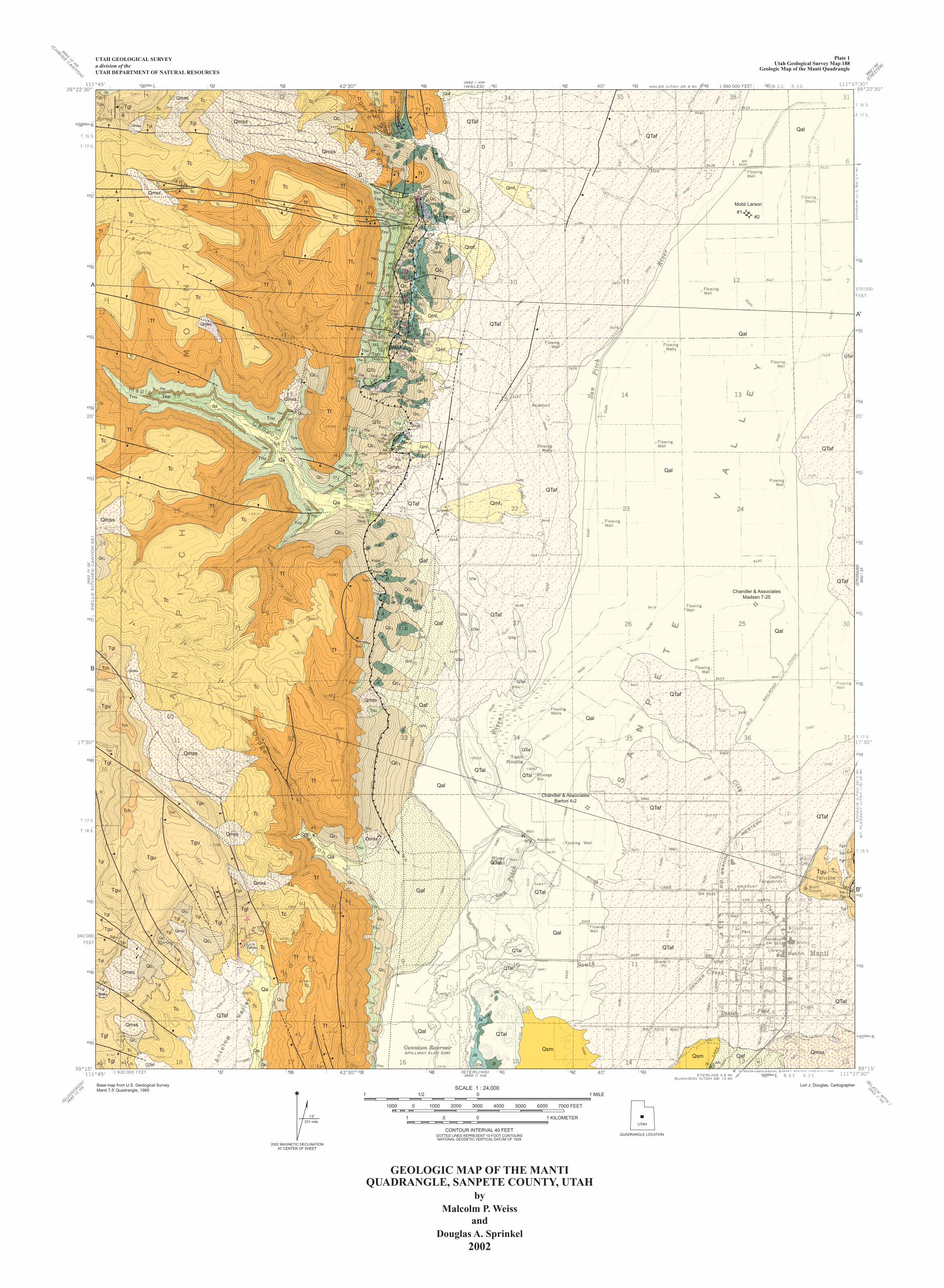
Qmss
D
F
F
D
D
D
D
D
D
Mobil Larson
#2#1
Chandler & AssociatesMadsen 7-25
Chandler & AssociatesBarton 4-2
70
A
A'
B'
B
1
6
925
57
88 3082
8253
4568
6580
40
30
14
202
33
20
2344
5862
82
29
56
55
5348
4664
68
40
30
5054
4755
50
50
50
7011
20
7072
73
87
60
6162
67
7246
43
42
22
63
6460
3256
32
55
39
707062
78
23
8785
2681
54
10
4426
15
27
30
8554
60
83
53
85
81
52
30
28 48
40
47
7070
74
70
17
52
38
57
10
10
6
35
4
3
37?
3
2
3
3
1
77
7
35
28
49
54
58
66 75
7949
44624
10
6
7
50
10
8
4
67
13
18
37 126
10
7
6
248
79
8075
43
569
5
12
5
3
3
8
Tgl
Qa
Qmss
Qmss
Qmss
Tgu Tgl
TglTgl
Tc
Tc
Tf
Tf
TcTc
Tc
Tc
Tf
Tc
TcTc
Tc
Tc
Tf
Tf
Tf
Tf
Tf
Tf
Tf
Tf
Tc Tc
Tc
TcTf
Tf
Tf
Tnu
Tncc
Tf
Tf
Tc
Tf
Tncc
Tncc
Tncc
Tncc
Tncc
TnuTnu
Tnu
Tnu
Tns
Tns
Tns
Tns
Tnu
Tns
Tns
TKnb
Tnu
TKnb
TKnbTns
TKnb
Tfw
Tfw
Tfw
Tfw
Tfw
Tfw
Tnu
Tfw
Tfw
Tfw
Tfw
Tfw
Tfw
Tfw
TKnb
TKnb
TKnb
TKnb
TKnb
Kspa
KspbKspa
Kc
Kc
Tnu
Tnu
Tnu
Tnu
Tnu
Tnu
Tnu
Tfw
Tfw
TnsQaf
Tf
Jt
Jt
Jt
Jt
Jt
Jt
Jt
Jt
Jt
JtJt
Jt
JtJt
Jt
Jt
Jt
Jt
Jt
Jt
Jt
Jt
Jt
Jt
Jt
Jt
Ja
Jt
Jt
Jt
Jt
Jt
Jt
Ja
Ja
Ja
Ja
Ja
Ja
KuQTc
Jt
Qa
Qmf2 Qmf1
Qc1
QafQc
2
Qc2
Qmf1
Qc1
Qc1
QTcQc1
Qmf1
Qmf1
Qmf1
Qmss
Qmf2
Qc2
Qc2
Qc2
Qc1
Qc1
Qc1
Qmf1
QTc
Qc1
Qmsl
Qmsl
QTcQTc
QTc
Qc2
JtJt
Qc1 QTaf
QTaf
QTaf
QTaf
QTaf
QTaf
QTaf
QTaf
QTaf
QTaf
QTafQal
Qal
Qal
Qal
Qal
Qal
QTal
Qal
Qal
Qc1
Qmss
Qmss
Qmsl
QTaf
Qmsl
QTaf
QTaf
QTaf
Tnu Tc
Tc
Tc
Tfw
Tns
Qc1
Qc1Qa
Qa
Qmss
Qmss
Qa
Qc1
Tnu
Tnu
Tnu
Tnu
Tns
Tns
Tfw
TfwQc1
Qc1
Qc1
Qc1
Qc1
Qc1
Qmf1
Qmss
Qmf1
Jt
Jt
Jt
JtJt
JtJt
Jt
Jt
Jt
Jt
Jt
Jt
Jt
Qa
Tc
Tc
Tc
Tc
Tc
Tc
Qmss
Qc1 QafKspa
Tnu
Tnu
Tnu
Tnu
Tnu
Kspa
QTal
QTal
QTal
QTal
QTal
QTal
Qaf
Qmf2
Qmf2
Tgl
Tch
Tch
Qmss
Qmss
Qc1
Qaf
Qaf
Qmss
Qmf2Jt
Tgl
Tgu
Tgu
Tgu
Tgu
Tgl
Tgl
Tgl
Tgl
QTal
QTalTch
Tch Tch
Tgu
Tc
Qmss
Tnu
Tnu
Qc1
Qa
Qc1
Qmf2Qmss
Tgl
Tgl
Tgl
Tch
Tch
Tgu
Tgu
Tgu
QTal
QTal
Tf
Tf
Tf
Qmss
Tgu
Qc1
Tnu
Tnu
Tnu
Tnu
Tnu
Tnu
Qc1
Qc1
Tgl
Tgl
Tgu
Tgl
Tgl
Tgl
Tgl Tgl
Tgl
Tgu
TguQc1
Qmsl
Qc1Qmss
QTal
QTal
QTal
Tc
TcQc1Qmss
Tgu
Tgl
Tgl
TguQmss
TcQc1
Qa
Qa
Ja
Ja
Jt
Jt
Jt
Qsm
Qmss
Qc1
Tc
Tc
Tc
Tc
Qc1
QsmQmss
QafKfvQTalQc1QTaf
QTaf
F
F
F
Tc
Plate 1Utah Geological Survey Map 188
Geologic Map of the Manti Quadrangle
UTAH GEOLOGICAL SURVEYa division of theUTAH DEPARTMENT OF NATURAL RESOURCES
UTAH
QUADRANGLE LOCATION
SCALE 1 : 24,000
1 .5 0 1 KILOMETER
CONTOUR INTERVAL 40 FEETDOTTED LINES REPRESENT 10-FOOT CONTOURSNATIONAL GEODETIC VERTICAL DATUM OF 1929
1 1/2 0 1 MILE
1000 0 1000 2000 3000 4000 5000 6000 7000 FEET
Base map from U.S. Geological SurveyManti 7.5' Quadrangle, 1965
Lori J. Douglas, Cartographer
2002 MAGNETIC DECLINATIONAT CENTER OF SHEET
231 mils
13
GEOLOGIC MAP OF THE MANTIQUADRANGLE, SANPETE COUNTY, UTAH
byMalcolm P. Weiss
andDouglas A. Sprinkel
2002
K
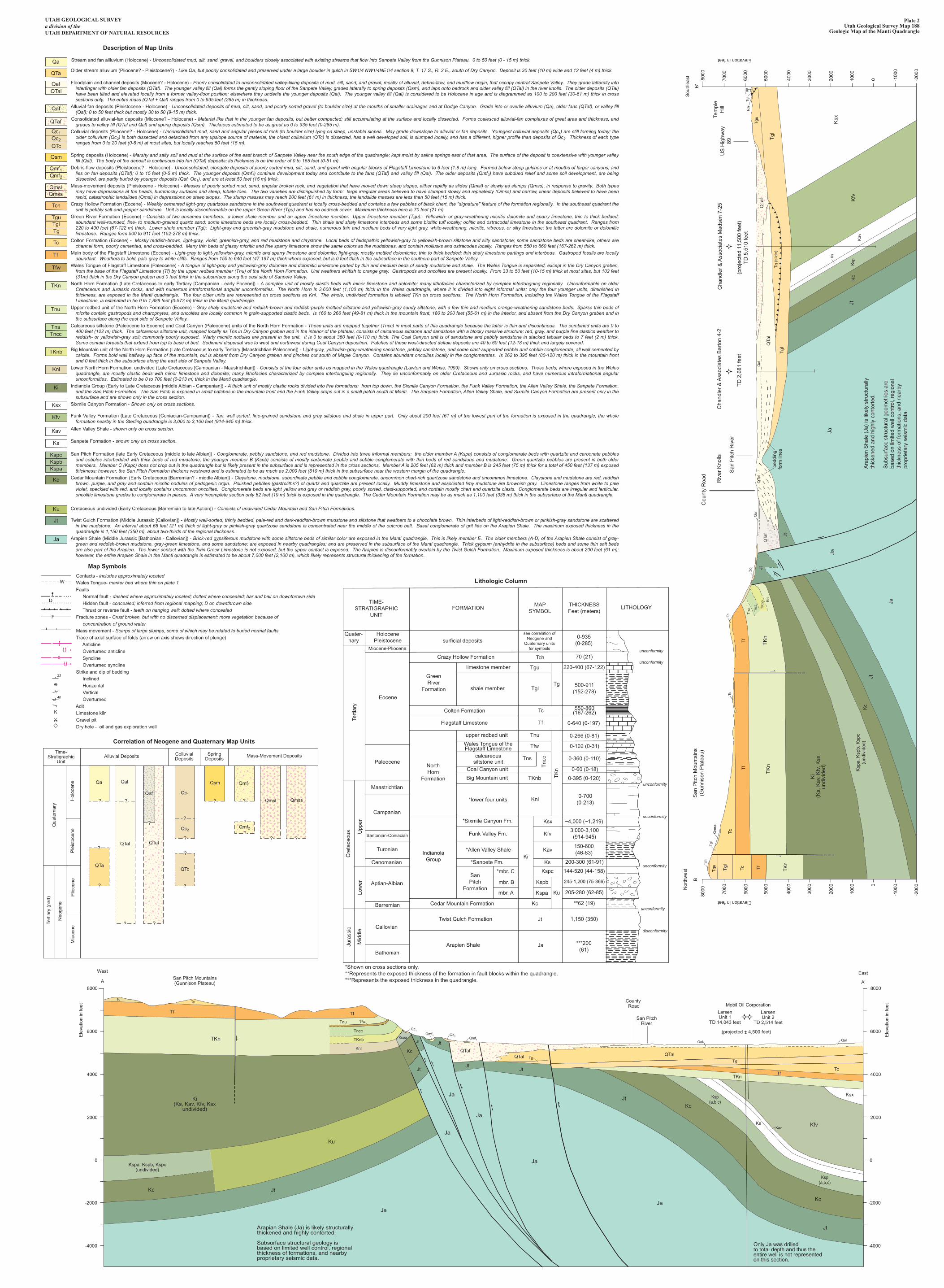
Tert
iary
(pa
rt)
Neo
gene
Mio
cene
Plio
cene
Qua
tern
ary
Ple
isto
cene
Hol
ocen
e
Time-Stratigraphic
UnitAlluvial Deposits Colluvial
DepositsSpring
DepositsMass-Movement Deposits
Qmss
Qmf1
Qmf2
?
?
?
??
?
?
?
?
?
?
? ?
??
?
Qsm
Qc1
Qc2
QalQa
QTal QTaf
QTcQTa
Qaf
TIME-STRATIGRAPHIC
UNITFORMATION
MAPSYMBOL
THICKNESSFeet (meters)
LITHOLOGY
Quater-nary
HolocenePleistocene
Miocene-Pliocene
surficial depositssee correlation of
Neogene andQuaternary units
for symbols
0-935(0-285)
500-911(152-278)
550-860(167-262)
70 (21)Tch
Tgu
Tgl
Tc
Tf
Tnu
Tns
TKnb
Knl
Ksx
Kfv
Kav
Ks
Ku
Kc
Jt
Ja
Kspc
Kspb
Kspa
Ki
Tnc
c
TK
n
Tfw
Tg
Crazy Hollow Formation
GreenRiver
Formation
limestone member
shale member
220-400 (67-122)
0-266 (0-81)
0-640 (0-197)
0-102 (0-31)
0-360 (0-110)
0-395 (0-120)
~4,000 (~1,219)
200-300 (61-91)
144-520 (44-158)
205-280 (62-85)
245-1,200 (75-366)
0-60 (0-18)
Colton Formation
Flagstaff Limestone
Eocene
Tert
iary
Paleocene
upper redbed unit
Wales Tongue of theFlagstaff Limestone
calcareoussiltstone unit
Coal Canyon unit
Big Mountain unit
NorthHorn
Formation
Maastrichtian
Campanian
*lower four units
*Sixmile Canyon Fm.
*Allen Valley Shale
0-700(0-213)
3,000-3,100(914-945)
150-600(46-83)
Funk Valley Fm.
*Sanpete Fm.
IndianolaGroup
Santonian-Coniacian
Turonian
Cenomanian
Upp
erLo
wer
Cre
tace
ous
Aptian-Albian
SanPitch
Formation
*mbr. C
mbr. B
mbr. A
**62 (19)
1,150 (350)
Cedar Mountain Formation
Twist Gulch Formation
Barremian
Callovian
Jura
ssic
Mid
dle
BathonianArapien Shale ***200
(61)
*Shown on cross sections only.**Represents the exposed thickness of the formation in fault blocks within the quadrangle.***Represents the exposed thickness in the quadrangle.
unconformity
unconformity
unconformity
unconformity
unconformity
unconformity
disconformity
A
West
8000
4000
6000
2000
0
-2000
-4000
Ele
vatio
n in
feet
A'
East
8000
4000
6000
2000
0
-2000
-4000
Ele
vatio
n in
feet
San Pitch Mountains(Gunnison Plateau)
County Road
San PitchRiver
Mobil Oil Corporation
LarsenUnit 1
TD 14,043 feet
LarsenUnit 2
TD 2,514 feet
(projected + 4,500 feet)
TcTc
Tf
Kc
Ku
Kc
Jt
Jt
JtJt
TgTg
TfTc
TKn
Qal
JtKc
Kc
KsKav
Kfv
KsxKsp(a,b,c)
Ksp(a,b,c)
Jt
Jt
Jt
JaJa
Ja
Ja
Ja
Ja
Tf
TfwTnu
Tncc
TKnb
Knl
Qc1
Qc2Qmf1
Qmf1TKn
Kspa, Kspb, Kspc(undivided)
Ki(Ks, Kav, Kfv, Ksx
undivided)
Arapian Shale (Ja) is likely structurallythickened and highly contorted.
Subsurface structural geology isbased on limited well control, regionalthickness of formations, and nearbyproprietary seismic data.
QTafQTal QTal
Qal
Only Ja was drilledto total depth and thus theentire well is not representedon this section.
Kspa
Tch
Tgu Tgl
Tgl
Qm
ss
Tc
TcTc
Tf
Tf
Kc
Jt
Ja
Tf
Jt
JtT
Kn
TK
nT
Kn
JaJa
Ki
(Ks,
Kav
, Kfv
, Ksx
undi
vide
d)
Tc
Qc 1
Tnu T
ncc
TK
nb
Knl
Qal
Qal
QTa
f
QTa
l
QTa
lQ
Taf
Tgl
Tgl
Tgu
Tch
Tgl
Tgu
JtK
cK
fv
Ksx
Ksp
Kav
Ks
Tg
(slid
e)
B
Nor
thw
est
8000
7000
4000
3000
6000
5000
2000
1000 0
-200
0
-100
0
Elevation in feet
B'
Sou
thea
st 8000
7000
4000
3000
6000
5000
2000
1000
0 -200
0
-100
0
Elevation in feet
San
Pitc
h M
ount
ains
(Gun
niso
n P
late
au)
San
Pitc
h R
iver
Riv
er K
nolls
Cou
nty
Roa
d
US
Hig
hway
89
Tem
ple
Hill
TD
2,6
81 fe
et
Cha
ndle
r &
Ass
ocia
tes
Bar
ton
4-2
(pro
ject
ed 1
1,50
0 fe
et)
TD
5,5
10 fe
et
Cha
ndle
r &
Ass
ocia
tes
Mad
sen
7-25
Ara
pien
Sha
le (
Ja)
is li
kely
str
uctu
rally
thic
kene
d an
d hi
ghly
con
tort
ed.
Sub
surf
ace
stru
ctur
al g
eom
etrie
s ar
eba
sed
on li
mite
d w
ell c
ontr
ol, r
egio
nal
thic
knes
s of
form
atio
ns, a
nd n
earb
ypr
oprie
tary
sei
smic
dat
a.
Ksp
a, K
spb,
Ksp
c(u
ndiv
ided
)
bedd
ing
form
line
s
Stream and fan allluvium (Holocene) - Unconsolidated mud, silt, sand, gravel, and boulders closely associated with existing streams that flow into Sanpete Valley from the Gunnison Plateau. 0 to 50 feet (0 - 15 m) thick. Older stream alluvium (Pliocene? - Pleistocene?) - Like Qa, but poorly consolidated and preserved under a large boulder in gulch in SW1/4 NW1/4NE1/4 section 9, T. 17 S., R. 2 E., south of Dry Canyon. Deposit is 30 feet (10 m) wide and 12 feet (4 m) thick.
Floodplain and channel deposits (Miocene? - Holocene) - Poorly consolidated to unconsolidated valley-filling deposits of mud, silt, sand, and gravel, mostly of alluvial, debris-flow, and mudflow origin, that occupy central Sanpete Valley. They grade latterally into interfinger with older fan deposits (QTaf). The younger valley fill (Qal) forms the gently sloping floor of the Sanpete Valley, grades laterally to spring deposits (Qsm), and laps onto bedrock and older valley fill (QTal) in the river knolls. The older deposits (QTal) have been tilted and elevated locally from a former valley-floor position; elsewhere they underlie the younger deposits (Qal). The younger valley fill (Qal) is considered to be Holocene in age and is diagrammed as 100 to 200 feet (30-61 m) thick in cross sections only. The entire mass (QTal + Qal) ranges from 0 to 935 feet (285 m) in thickness.
Alluvial-fan deposits (Pleistocene - Holocene) - Unconsolidated deposits of mud, silt, sand, and poorly sorted gravel (to boulder size) at the mouths of smaller drainages and at Dodge Canyon. Grade into or overlie alluvium (Qa), older fans (QTaf), or valley fill (Qal); 0 to 50 feet thick but mostly 30 to 50 (9-15 m) thick.
Consolidated alluvial-fan deposits (Miocene? - Holocene) - Material like that in the younger fan deposits, but better compacted; still accumulating at the surface and locally dissected. Forms coalesced alluvial-fan complexes of great area and thickness, and grades to valley fill (QTal and Qal) and spring deposits (Qsm). Thickness estimated to be as great as 0 to 935 feet (0-285 m).
Colluvial deposits (Pliocene? - Holocene) - Unconsolidated mud, sand and angular pieces of rock (to boulder size) lying on steep, unstable slopes. May grade downslope to alluvial or fan deposits. Youngest colluvial deposits (Qc1) are still forming today; the older colluvium (Qc2) is both dissected and detached from any upslope source of material; the oldest colluvium (QTc) is dissected, has a well developed soil, is slumped locally, and has a different, higher profile than deposits of Qc2. Thickness of each type ranges from 0 to 20 feet (0-6 m) at most sites, but locally reaches 50 feet (15 m).
Spring deposits (Holocene) - Marshy and salty soil and mud at the surface of the east branch of Sanpete Valley near the south edge of the quadrangle; kept moist by saline springs east of that area. The surface of the deposit is coextensive with younger valley fill (Qal). The body of the deposit is continuous into fan (QTal) deposits; its thickness is on the order of 0 to 165 feet (0-51 m).
Debris-flow deposits (Pleistocene? - Holocene) - Unconsolidated, elongate deposits of poorly sorted mud, silt, sand, and gravel with angular blocks of Flagstaff Limestone to 6 feet (1.8 m) long. Formed below steep gulches or at mouths of larger canyons, and lies on fan deposits (QTaf); 0 to 15 feet (0-5 m) thick. The younger deposits (Qmf1) continue development today and contribute to the fans (QTaf) and valley fill (Qal). The older deposits (Qmf2) have subdued relief and some soil development, are being dissected, are partly buried by younger deposits (Qaf, Qc1), and are at least 50 feet (15 m) thick.
Mass-movement deposits (Pleistocene - Holocene) - Masses of poorly sorted mud, sand, angular broken rock, and vegetation that have moved down steep slopes, either rapidly as slides (Qmsl) or slowly as slumps (Qmss), in response to gravity. Both types may have depressions at the heads, hummocky surfaces and steep, lobate toes. The two varieties are distinguished by form: large irregular areas believed to have slumped slowly and repeatedly (Qmss) and narrow, linear deposits believed to have been rapid, catastrophic landslides (Qmsl) in depressions on steep slopes. The slump masses may reach 200 feet (61 m) in thickness; the landslide masses are less than 50 feet (15 m) thick.
Crazy Hollow Formation (Eocene) - Weakly cemented light-gray quartzose sandstone in the southwest quadrant is locally cross-bedded and contains a few pebbles of black chert, the "signature" feature of the formation regionally. In the southeast quadrant the unit is pebbly salt-and-pepper sandstone. Unit is locally disconformable on the upper Green River (Tgu) and has no bedrock cover. Maximum thickness here is 70 feet (21 m).
Green River Formation (Eocene) - Consists of two unnamed members: a lower shale member and an upper limestone member. Upper limestone member (Tgu): Yellowish- or gray-weathering micritic dolomite and sparry limestone, thin to thick bedded; abundant well-rounded, fine- to medium-grained quartz sand; some limestone beds are locally cross-bedded. Thin shale and shaly limestone interbeds and some biotitic tuff locally; oolitic and ostracodal limestone in the southeast quadrant. Ranges from 220 to 400 feet (67-122 m) thick. Lower shale member (Tgl): Light-gray and greenish-gray mudstone and shale, numerous thin and medium beds of very light gray, white-weathering, micritic, vitreous, or silty limestone; the latter are dolomite or dolomitic limestone. Ranges form 500 to 911 feet (152-278 m) thick.
Colton Formation (Eocene) - Mostly reddish-brown, light-gray, violet, greenish-gray, and red mudstone and claystone. Local beds of feldspathic yellowish-gray to yellowish-brown siltstone and silty sandstone; some sandstone beds are sheet-like, others are channel form, poorly cemented, and cross-bedded. Many thin beds of glassy micritic and fine sparry limestone show the same colors as the mudstones, and contain mollusks and ostracodes locally. Ranges from 550 to 860 feet (167-262 m) thick.
Main body of the Flagstaff Limestone (Eocene) - Light-gray to light-yellowish-gray, micritic and sparry limestone and dolomite; light-gray, mostly mottled dolomicrite; thin to thick bedded; thin shaly limestone partings and interbeds. Gastropod fossils are locally abundant. Weathers to bold, pale-gray to white cliffs. Ranges from 155 to 640 feet (47-197 m) thick where exposed, but is 0 feet thick in the subsurface in the southern part of Sanpete Valley.
Wales Tongue of Flagstaff Limestone (Paleocene) - A tongue of light-gray and yellowish-gray dolomite and dolomitic limestone parted by thin and medium beds of sandy mudstone and shale. The Wales Tongue is separated, except in the Dry Canyon graben, from the base of the Flagstaff Limestone (Tf) by the upper redbed member (Tnu) of the North Horn Formation. Unit weathers whitish to orange gray. Gastropods and oncolites are present locally. From 33 to 50 feet (10-15 m) thick at most sites, but 102 feet (31m) thick in the Dry Canyon graben and 0 feet thick in the subsurface along the east side of Sanpete Valley.
North Horn Formation (Late Cretaceous to early Tertiary [Campanian - early Eocene]) - A complex unit of mostly clastic beds with minor limestone and dolomite; many lithofacies characterized by complex intertonguing regionally. Unconformable on older Cretaceous and Jurassic rocks, and with numerous intraformational angular unconformities. The North Horn is 3,600 feet (1,100 m) thick in the Wales quadrangle, where it is divided into eight informal units; only the four younger units, diminished in thickness, are exposed in the Manti quadrangle. The four older units are represented on cross sections as Knl. The whole, undivided formation is labeled TKn on cross sections. The North Horn Formation, including the Wales Tongue of the Flagstaff Limestone, is estimated to be 0 to 1,889 feet (0-573 m) thick in the Manti quadrangle.
Upper redbed unit of the North Horn Formation (Eocene) - Gray shaly mudstone and reddish-brown and reddish-purple mottled siltstone and yellowish-gray sandy siltstone, with a few thin and medium orange-weathering sandstone beds. Sparse thin beds of micrite contain gastropods and charophytes, and oncolites are locally common in grain-supported clastic beds. Is 160 to 266 feet (49-81 m) thick in the mountain front, 180 to 200 feet (55-61 m) in the interior, and absent from the Dry Canyon graben and in the subsurface along the east side of Sanpete Valley.
Calcareous siltstone (Paleocene to Eocene) and Coal Canyon (Paleocene) units of the North Horn Formation - These units are mapped together (Tncc) in most parts of this quadrangle because the latter is thin and discontinous. The combined units are 0 to 400 feet (122 m) thick. The calcareous siltstone unit, mapped locally as Tns in Dry Canyon graben and in the interior of the plateau, consists of calcareous siltstone and sandstone with a blocky massive structure; red, gray, and purple fine clastics weather to reddish- or yellowish-gray soil; commonly poorly exposed. Warty micritic nodules are present in the unit. It is 0 to about 360 feet (0-110 m) thick. The Coal Canyon unit is of sandstone and pebbly sandstone in stacked tabular beds to 7 feet (2 m) thick. Some contain foresets that extend from top to base of bed. Sediment dispersal was to west and northwest during Coal Canyon deposition. Patches of these west-directed deltaic deposits are 40 to 60 feet (12-18 m) thick and largely covered.
Big Mountain unit of the North Horn Formation (Late Cretaceous to early Tertiary [Maastrichtian-Paleocene]) - Light-gray, yellowish-gray-weathering sandstone, pebbly sandstone, and some clast-supported pebble and cobble conglomerate, all well cemented by calcite. Forms bold wall halfway up face of the mountain, but is absent from Dry Canyon graben and pinches out south of Maple Canyon. Contains abundant oncolites locally in the conglomerates. Is 262 to 395 feet (80-120 m) thick in the mountain front and 0 feet thick in the subsurface along the east side of Sanpete Valley.
Lower North Horn Formation, undivided (Late Cretaceous [Campanian - Maastrichtian]) - Consists of the four older units as mapped in the Wales quadrangle (Lawton and Weiss, 1999). Shown only on cross sections. These beds, where exposed in the Wales quadrangle, are mostly clastic beds with minor limestone and dolomite; many lithofacies characterized by complex intertonguing regionally. They lie unconformably on older Cretaceous and Jurassic rocks, and have numerous intraformational angular unconformities. Estimated to be 0 to 700 feet (0-213 m) thick in the Manti quadrangle.
Indianola Group (Early to Late Cretaceous [middle Albian - Campanian]) - A thick unit of mostly clastic rocks divided into five formations: from top down, the Sixmile Canyon Formation, the Funk Valley Formation, the Allen Valley Shale, the Sanpete Formation, and the San Pitch Formation. The San Pitch is exposed in small patches in the mountain front and the Funk Valley crops out in a small patch south of Manti. The Sanpete Formation, Allen Valley Shale, and Sixmile Canyon Formation are present only in the subsurface and are shown only in the cross section.
Sixmile Canyon Formation - Shown only on cross sections.
Funk Valley Formation (Late Cretaceous [Coniacian-Campanian]) - Tan, well sorted, fine-grained sandstone and gray siltstone and shale in upper part. Only about 200 feet (61 m) of the lowest part of the formation is exposed in the quadrangle; the whole formation nearby in the Sterling quadrangle is 3,000 to 3,100 feet (914-945 m) thick.
Allen Valley Shale - shown only on cross section.
Sanpete Formation - shown only on cross seciton.
San Pitch Formation (late Early Cretaceous [middle to late Albian]) - Conglomerate, pebbly sandstone, and red mudstone. Divided into three informal members: the older member A (Kspa) consists of conglomerate beds with quartzite and carbonate pebbles and cobbles interbedded with thick beds of red mudstone; the younger member B (Kspb) consists of mostly carbonate pebble and cobble conglomerate with thin beds of red sandstone and mudstone. Green quartzite pebbles are present in both older members. Member C (Kspc) does not crop out in the quadrangle but is likely present in the subsurface and is represented in the cross sections. Member A is 205 feet (62 m) thick and member B is 245 feet (75 m) thick for a total of 450 feet (137 m) exposed thickness; however, the San Pitch Formation thickens westward and is estimated to be as much as 2,000 feet (610 m) thick in the subsurface near the western margin of the quadrangle.
Cedar Mountain Formation (Early Cretaceous [Barremian? - middle Albian]) - Claystone, mudstone, subordinate pebble and cobble conglomerate, uncommon chert-rich quartzose sandstone and uncommon limestone. Claystone and mudstone are red, reddish brown, purple, and gray and contain micritic nodules of pedogenic orgin. Polished pebbles (gastroliths?) of quartz and quartzite are present locally. Muddy limestone and associated limy mudstone are brownish gray. Limestone ranges from white to pale violet, speckled with red, and locally contains uncommon oncolites. Conglomerate beds are light yellow and gray or reddish gray, poorly sorted, clast-supported, and contain mostly chert and quartzite clasts. Conglomerate beds are irregular and lenticular, oncolitic limestone grades to conglomerate in places. A very incomplete section only 62 feet (19 m) thick is exposed in the quadrangle. The Cedar Mountain Formation may be as much as 1,100 feet (335 m) thick in the subsurface of the Manti quadrangle.
Cretaceous undivided (Early Cretaceous [Barremian to late Aptian]) - Consists of undivided Cedar Mountain and San Pitch Formations.
Twist Gulch Formation (Middle Jurassic [Callovian]) - Mostly well-sorted, thinly bedded, pale-red and dark-reddish-brown mudstone and siltstone that weathers to a chocolate brown. Thin interbeds of light-reddish-brown or pinkish-gray sandstone are scattered in the mudstone. An interval about 68 feet (21 m) thick of light-gray or pinkish-gray quartzose sandstone is concentrated near the middle of the outcrop belt. Basal conglomerate of grit lies on the Arapien Shale. The maximum exposed thickness in the quadrangle is 1,150 feet (350 m), about two-thirds of the regional thickness.
Arapien Shale (Middle Jurassic [Bathonian - Callovian]) - Brick-red gypsiferous mudstone with some siltstone beds of similar color are exposed in the Manti quadrangle. This is likely member E. The older members (A-D) of the Arapien Shale consist of gray-green and reddish-brown mudstone, gray-green limestone, and some sandstone; are exposed in nearby quadrangles; and are preserved in the subsurface of the Manti quadrangle. Thick gypsum (anhydrite in the subsurface) beds and some thin salt beds are also part of the Arapien. The lower contact with the Twin Creek Limestone is not exposed, but the upper contact is exposed. The Arapien is disconformably overlain by the Twist Gulch Formation. Maximum exposed thickness is about 200 feet (61 m); however, the entire Arapien Shale in the Manti quadrangle is estimated to be about 7,000 feet (2,100 m), which likely represents structural thickening of the formation.
Contacts - includes approximately located Wales Tongue- marker bed where thin on plate 1 Faults Normal fault - dashed where approximately located; dotted where concealed; bar and ball on downthrown side Hidden fault - concealed; inferred from regional mapping; D on downthrown side Thrust or reverse fault - teeth on hanging wall; dotted where concealed Fracture zones - Crust broken, but with no discerned displacement; more vegetation because of concentration of ground water Mass movement - Scarps of large slumps, some of which may be related to buried normal faults Trace of axial surface of folds (arrow on axis shows direction of plunge) Anticline Overturned anticline Syncline Overturned syncline Strike and dip of bedding Inclined Horizontal Vertical Overturned Adit Limestone kiln Gravel pit Dry hole - oil and gas exploration well
23
40
K
D
W
F
Plate 2Utah Geological Survey Map 188
Geologic Map of the Manti Quadrangle
UTAH GEOLOGICAL SURVEYa division of theUTAH DEPARTMENT OF NATURAL RESOURCES
Description of Map Units
Map Symbols
Correlation of Neogene and Quaternary Map Units
Lithologic Column
Qa
QTa
QTalQal
Qc1Qc2
QTc
Qsm
Tch
TguTglTg
Tc
Tf
Tfw
TKn
Tnu
Tncc
TKnb
Knl
Ki
Ksx
Kfv
Kav
Ks
KspcKspbKspa
Kc
Ku
Jt
Ja
Tns
Qaf
QTaf
Qmf1Qmf2
QmslQmss
Qmsl
?