Embed Size (px)
Citation preview

i

i
GEOLOGICAL REPORT ON ESTIMATION OF IRON ORE RESERVES IN RESPECT OF
M/s MINERAL MINERS AND TRADERS MINE LEASE AREA (ML. No.2185A) DISTRICT: BALLARI, KARNATAKA
SALIENT FEATURES
1 Name and location of the block
M/s Mineral Miners and Traders, Mine Lease Area (ML. No. 2185A) Taluk and Dist: Ballari, Karnataka, lies between Longitudes 76º46’57.01” and 76º46’53.10” and Latitudes 15º07’06.02” and 15º06’35.70”. The area is covered in Survey of India Toposheet No.57 A/16.
2 Accessibility The mine lease area is 5 m from Haragandoni village and 13 km from Kuditini as well as Ballary.
3 Objective i) Borehole fixation, determination of coordinates and RL of boreholes
ii) Detailed geological mapping iii) Estimation of reserves in respect of ‘C’ category
mine as per UNFC guidelines 4 Quantum of work
a) Geological Mapping b) i) Core drilling ii) RC drilling c) Total Meterage drilled d) Chemical Analysis i) Primary (Fe,SiO2,Al203,) a) Core b) R.C. ii) Specific gravity
0.4610 sq. km (1:1000 RF) 129.50m (2 Bhs) 775.00m (13 Bhs) 904.50m(15 Bhs) 845 nos.
70 nos. 775 nos. 7 nos.
5 Duration of work April-2015 to June-2015 6 Geology and structure The Sandur Schist Belt is known for its economic
deposits of Iron and Manganese and studied in detail by many prominent workers like New Bold (1838), Foote (1895), Roy and Biswas (1983), Martin and Mukhopadhyay (1987 and 1993), Naqvi et.al. (1987) on various aspects like depositional environment, structure etc. Iron ore and banded ferruginous cherty quartzite, are intimately associated with gabbro of pre-tectonic and post tectonic origin. The hill ranges trend in NNW-SSE direction, which are similar to regional tectonic trend of the Sandur Schist Belt. The area has under gone two phases of deformation [F1 and F2] and metamorphism. The axial trace of F1 have NNW-SSE trend which is refolded by open F2 folds trending in ENW-WSE direction. The primary structure of banded iron ore formation is bedding and pene-contemporaneous faults; schistosity and fracture cleavage are also

ii
common. Repetitions of iron ore band, which cause the thickening of ore at places, are due to diastrophic folds.
7 No. of BHs drilled up to basement
Nil ; Grid pattern : 100 x 100 and 100 x 150
8 Highest RL in lease area Lowest RL in lease area Deepest BH (m)
836.417 m 562.537m i) Drilled- wise : 615.722 (MMT-01 ) ii) Intersection-wise : 623.222 (MMTR-03)
9 Thickness at 45% Fe cut-off
Minimum – 0.94 m (MMTR-13) Maximum – 58.75 m (MMT-06) Iron ore continues beyond the explored depth in mine lease area.
10 Overburden Soil / Scree, ferruginous clay and Metabasalt 11 Logging and Sampling 904.50 m and 845 nos. 12 Samples analyzed for Fe (%), SiO2 (%), Al2O3 (%)
13 Average core recovery 85-90% 14 No. of Geological cross-
sections 11 nos. along N45ºE-S45ºW (S1-S1’ – S11-S11’)
15 Specifications (Based on Fe %)
>45% Threshold value
16 Structure Janikunta range NNW-SSE with steep easterly dip of 60°-80°
17 Nature / Type of Ore i) Lateritic ore, Haematitic ore, Soft Laminated ore, Powdery ore, Blue dust and Siliceous ore. ii) Waste type / OB / IB – Laterite, Ferruginous clay,
Metabasalt and BHQ 18 Stratigraphy Lateritic Ore, Ferruginous Clay, Metabasalt,
Massive/ Laminated Ore, Phyllite, Blue Dust, Ferruginous shale, BHQ / BHJ
19 Ore body dimension Iron Ore Bands Trend NW-SE/Steep easterly dip of
65º to 82º Strike length 397.50 m (S4,S7 to S11 and
beyond) Av. Wide area 450 m
20 Intercalation Red Ochre, BHQ, Metabasalt and Ferruginous Clay. 21 Ore Reserves (at 45% Fe) Based on the estimation by geological cross
section method, the net in-situ reserves is 9.224 m.t. with average grade of 53.26 % Fe, 19.80 % SiO2 and 6.12% Al2O3 have been estimated. The overall ratio of SiO2: Al2O3 is 8.72. Rice ratio for is 2.63.
22 Recommendations M/s Mineral Miners and Traders, Mine Lease Area (M.L. No. 2185A) has good potential that would be amenable to systematic scientific mining.

iii
GEOLOGICAL REPORT ON ESTIMATION OF IRON ORE RESERVES IN RESPECT OF
M/s MINERAL MINERS AND TRADERS MINE LEASE AREA (ML NO. 2185A) DISTRICT: BALLARI, KARNATAKA
LIST OF CONTENTS
CHAPTER
NO. CONTENTS
PAGE NO.
SALIENT FEATURES i-ii 1.0.0 INTRODUCTION 1 - 3
1.1.0 General 1 1.2.0 Location 2 1.3.0 Accessibility 2 1.4.0 Physiography 2 1.5.0 Climate 2 1.6.0 Scope of Work 3 1.7.0 Acknowledgements 3
2.0.0 REGIONAL GEOLOGY AND STRUCTURE 4 – 9
2.1.0 Background Information 4 2.2.0 Classification of Iron Ore Deposits 5 2.3.0 Regional Geology 7 2.4.0 Structure 7 2.5.0 Geology of the Area 8 2.6.0 Structural Control 9
3.0.0 EXPLORATION BY MECL 10 – 17
3.1.0 Objective 10 3.2.0 Summary of Exploration work done 10 3.3.0 Surface Survey 10 3.4.0 Geological Mapping 11 3.5.0 Exploratory Drilling 11 3.6.0 Core Logging 11 3.7.0 Primary Sampling 11 3.8.0 Specific Gravity Determination 12
4.0.0 MINERALISATION AND CHARACTERISTICS OF IRON ORE
18 – 22
4.1.0 Mineralisation 18 4.2.0 Types of Ores 18 4.3.0 Grade Classification 19 4.4.0 Depth Persistence 20 4.5.0 Mineralisation Factor 20 4.6.0 Physical Characteristics of Ore 21 4.7.0 Chemical Characteristics of the Iron Ore 21 4.8.0 Ore body dimension 21
5.0.0 METHOD OF RESOURCE ESTIMATION 23 – 27
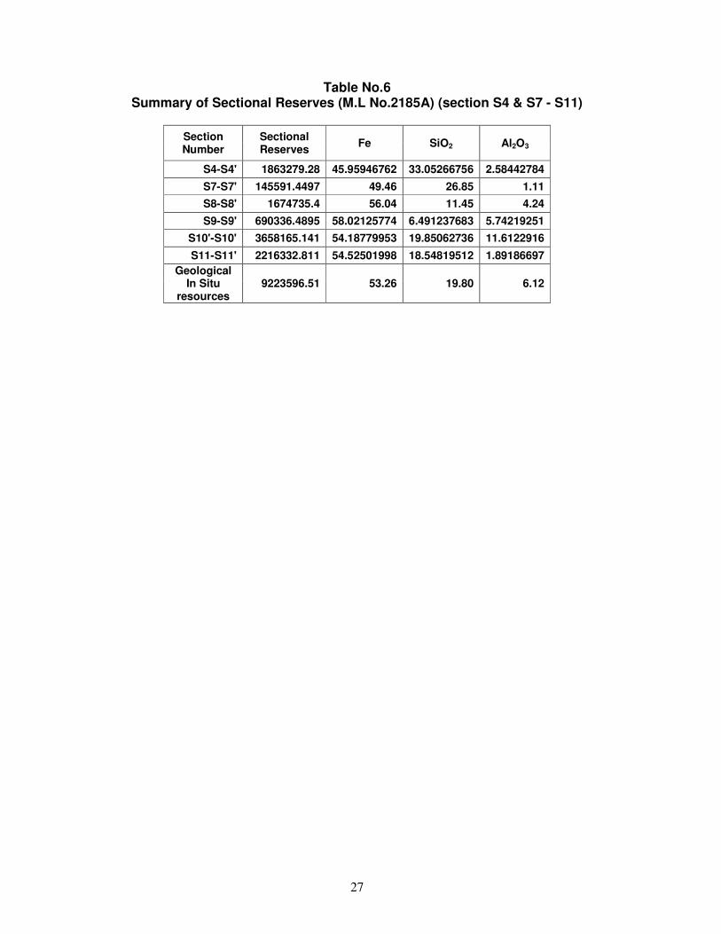
5.1.0 Resource estimation by geological cross-section 23 5.2.0 Shape of Ore body 23 5.3.0 Estimation of Reserves and Grade 24 5.4.0 Sectional Reserves 24

iv
CHAPTER NO.
CONTENTS PAGE NO.
5.5.0 Rice Ratio 24 6.0.0 RELIABILITY OF ESTIMATION 28 – 37
6.1.0 Frequency Distribution 28 6.2.0 Accuracy of Analytical Procedure 28
7.0.0 CONCLUSIONS AND RECOMMENDATIONS 38
7.1.0 Conclusions 38 7.2.0 Recommendations 38

v
GEOLOGICAL REPORT ON ESTIMATION OF IRON ORE RESERVES IN RESPECT OF
M/s MINERAL MINERS AND TRADERS MINE LEASE AREA (ML No. 2185A) DISTRICT: BALLARI, KARNATAKA
LIST OF ANNEXURES
ANNEXURE No.
TITLE PAGE
No.
I Details of Triangulation Stations 1 II Details of Survey particulars of boreholes drilled by MECL 1
IIIA Detailed Litholog of boreholes drilled (core drilling) by MECL 1-7 IIIB Detailed Litholog and analytical details of boreholes (Reverse
Circulation drilling) drilled by MECL. 1-24
IV Analytical Results of Primary Samples (Core Drilling] 1-3 V Details of Concise Litholog of boreholes 1-15 VI Contract Agreement 1-9
LIST OF TABLES
TABLE NO.
TITLE PAGE
No.
1 Quantum of work executed in M/s Mineral Miners and Traders , Mine Lease Area (ML No. 2185A)
3
2 Details of Iron Ore zone Intersected in the Boreholes (at 45% Fe cut-off)
19
3 Details of Iron Ore zone Intersected in the Boreholes (at 55% Fe) 19 4 Details of Iron Ore zone Intersected in the Boreholes (at 35% Fe) 20 5 Estimation of ore reserves by cross section method 26
6 Summary of Sectional Reserves (section S4 & S7-S11) 27
LIST OF PLATES
No. TITLE R.F.
I Location Map 1 : 200000 II Regional Geological Map 1 : 100000 III Topographic and Geological Map of M/s Mineral Miners and
Traders, Mine Lease Area (M.L.No.2185A) 1 : 1000
IV Graphic Llithologs with Histograms of boreholes (MMT- 1, MMTR- 2-5, MMT- 6, MMTR- 7-15)
1 : 500
V A Geological Cross Sections (S1 - S1’ to S3 - S3’) 1 : 1000 V B Geological Cross Sections (S4 - S4’ to S6 - S6’) 1 : 1000 V C Geological Cross Sections (S7 - S7’ to S9 - S9’) 1 : 1000 V D Geological Cross Sections (S10 - S10’ to S11 - S11’) 1 : 1000

vi
GEOLOGICAL REPORT ON
ESTIMATION OF IRON ORE RESERVES IN RESPECT OF M/s MINERAL MINERS AND TRADERS
MINE LEASE AREA (ML No. 2185A) DISTRICT: BALLARI, KARNATAKA
LIST OF TEXT PLATES
TEXT
PLATE NO.
TITLE PAGE NO.
1 Iron Ore Deposits of India 6 2 Typical geological cross section along Section line S7’-S7’ 25 3 Histogram of Primary Sample values 29 4 Histogram of Primary Sample values 29 5 Histogram of Primary Sample values 30 6 Histogram of zone data - Fe 30 7 Histogram of zone data - SiO2 31 8 Histogram of zone data -Al2O3 31 9 Cumulative distribution of the grade of Fe % entire data 32
10 Cumulative distribution of the grade of SiO2% entire data 33 11 Cumulative distribution of the grade of Al2O3% entire data 34 12 Cumulative distribution of the grade of Fe % zone data 35 13 Cumulative distribution of the grade of SiO2% zone data 36 14 Cumulative distribution of the grade of Al2O3% zone data 37

1
GEOLOGICAL REPORT ON ESTIMATION OF IRON ORE RESERVES IN RESPECT OF M/s MINERAL MINERS AND TRADERS MINE LEASE AREA
(ML. No. 2185A), DISTRICT: BALLARI, KARNATAKA
CHAPTER-1 1.0.0 INTRODUCTION 1.1.0 GENERAL 1.1.1 The extensive exploitation of Iron ore by small and large lease area holders
by violating all norms fixed by the government, besides, the illegal mining beyond their lease boundary by few mine owners had forced the government to stop mining activity and cancelled the mining leases since September 2011 by the verdict of Hon’ble Supreme Court of India in its Order dated: 24.02.2014. Accordingly, a committee was formed to assess the extent of encroachment / violation based on the joint survey conducted by authorities under the Chairmanship of the Chief Secretary to Government of Karnataka. Considering the extent of encroachment, 51 mines have been grouped under C-category mines and the mining licenses of these mines were cancelled. As per the guidelines Director, Dement of Mines and Geology vide letter no. GO No.CI79MMM 2013 [Vol-III] Bengaluru dated 14-11-2014 for carrying out exploration on estimation of iron ore reserves/resources for 9 C category mines of which 7 mines are in Sandur of Ballari district and 2 mines in Chitradurga district. The subsequent detailed discussions with official of IBM, DMG and MECL, it was decided to restrict core drilling method to less than 20% and enhance the RC drilling to more than 80%.
1.1.2 MECL officials visited 15 abandoned C-Category iron ore mines in Sandur
area of Ballari district and Hiriyur area of Chitradurga district along with DMG officials between 19-3-2014 to 23-3-2014 in prelude to the exploration in the C-Category mines. It is observed that, no systematic mining being done, no old exploration / Borehole data or chemical data and no updated Surface Plan is available for planning further exploration.
1.1.3 Based on the available Surface Plan and GPS Survey data provided by DMG
Karnataka, the proposal for detailed exploration for iron ore in 7 abandoned C category mines located in Ramgad Range, NEB Range in Ballari district and 2 mines in Chitradurga district, Karnataka were prepared.
1.1.4 Sandur Schist Belt is one of the younger schist belts of Dharwar Super Group
occupied in about 2500 Sq.km area between Ballari, Hospet and Sandur in the Ballari district of Karnataka is known for its rich accumulation of both Iron and Manganese ores. Extensive Iron and Manganese Ore Mining is the main activity in Sandur, Hospet and Ballari areas.
1.1.5 In future, almost entire Europe (excluding former USSR), Japan, Korea, China
and other Asian Countries will nearly depend upon import of iron ore. The main exporters will be Brazil, Oceania [Australia, New Zealand etc.) and former USSR. India has a good export market in the eastern sector as

2
Australia seems to be the sole major competitor; besides, India has a good market even in Europe and Africa. Therefore, it is pertinent to explore large areas to cater to heavy export of iron ore.
1.1.6 The Ramandurg, Kumaraswamy, Deodari, Donimalai, Thimmappanagudi,
NEB range and Copper mountain Ranges are the most important iron ore mining centers of Ballari - Hospet area.
1.2.0 LOCATION 1.2.1 M/s Mineral Miners and Traders Mine Lease Area (ML No. 2185A) falls on
Janikunta range of Sandur Schist Belt, at a distance of about 55 kms from Sandur and 5 kms from Haraganidoni village and 13 km from Kuditini as well as Ballari, lies between Longitudes 76º46’57.01” and 76º46’53.10” and Latitudes 15º07’06.02” and 15º06’35.70”. The area is covered in Survey of India Toposheet No.57 A/16 Plate-I).
1.2.2 The Sandur Schist Belt lies between Longitudes 76º22’ and 76º52’ and
Latitudes 14º50’ and 15º17’. The area is covered in Survey of India Toposheet Nos.57 A/7, 8, 11,12,15,16 and 57 B/9.
1.2.3 Ballari, Sandur and Hospet are the important townships of the area. Sandur is
the tehsil headquarter and located in the south central of Sandur Schist Belt. Ballari is the district headquarter, which is 60km from Sandur. Donimali is the NMDC Township, at a distance of about 15 km from Sandur. Hospet is the important township in the area and it is 30km from Sandur.
1.2.4 Jindal had established Vijayanagar Steels (JSW) near Toranagallu (R.S.),
with Thimmappangudi block ore reserves as captive mine. 1.3.0 ACCESSIBILITY 1.3.1 The mine lease area is accessible from Kuditini and Ballari by 13 km.
Bengaluru is the State capital and it is at about 340 km from Sandur by road and accessible by train from Hospet and Toranagallu,
1.4.0 PHYSIOGRAPHY 1.4.1 Physiography of the area is characterized by two elongated ridges trending
NNW-SSE. The western ridge is named as Ramandurg range and the eastern ridge is named as Donimali range and the E-W trending South East extension of Ramandurg range is called Kumaraswamy range. The height of these hill ranges is between 600 to 1100m from MSL.
1.5.0 CLIMATE 1.5.1 The Sandur Schist Belt area of Ballari district experience dry semi-arid climate
with annual rainfall varying from 40cm to 80cm. The monsoon begins in June first week and continues up to September and winter from the month of

3
October to January is somewhat pleasant However, hot to very hot summer is from the month of February to May.
1.6.0 SCOPE OF WORK
TABLE-1 QUANTUM OF WORK EXECUTED IN
M/s MINERAL MINERS AND TRADERS, MINE LEASE AREA (ML. NO. 2185A)
Sl. No Activity Quantity
1 Topographical Survey - on 1:1000 scale ( Dove tailing of data provided by DMG, Karnataka)
46.10 Ha
2 Geological Mapping 0.4610 sq. km. 3 Survey
i) Triangulation/Traversing 46.10 Ha ii) BH Fixation 15 nos. iii) Determination of RL and Co-ordinates 15 nos.
4 Exploratory Drilling
i) Core Drilling 129.50 ( 2 Bhs) ii) RC Drilling 775.00m ( 13 Bhs)
5 Geological Activities i) Core Logging 904.50 m ii) Sampling 845 nos.
6 Chemical Analysis : i) Primary (Fe,Sio2 andAl2O3) 845 nos. ii) Specific Gravity determination 7 nos.
1.7.0 ACKNOWLEDGEMENTS 1.7.1 MECL is highly thankful to Ore resource estimation committee for its
suggestions and valuable guidance in planning and execution of the proposed exploration in ‘C’ - Category iron ore mines of Ballari – Hospet area, Karnataka.
1.7.2 MECL places on record its profuse thanks to Director, Directorate of Mines
and Geology (DMG), Karnataka for assigning the responsibility of exploration in M/s Mineral Miners and Traders Mine Lease Area (ML No. 2185A) Ballari district, Karnataka.
1.7.3 MECL also gratefully acknowledges the co-operation in execution of
exploration activity at M/s Mineral Miners and Traders Mine Lease Area (M.L.No.2185A) by the officials of Directorate of Mines and Geology, Ballari and Hospet.

4
CHAPTER-2
2.0.0 REGIONAL GEOLOGY AND STRUCTURE 2.1.0 BACKGROUND INFORMATION 2.1.1 H. James defined iron formation as a “Chemical sediment, typically thin
bedded or laminated, containing 15% or more iron of sedimentary origin and commonly but not necessarily containing layers of Chert”. Banded Iron Formation (BIF) has been formed within a single epoch of earth between 1900 and 2500 million years ago. The amount of iron deposited in this epoch of sedimentation is quite enormous.
2.1.2 The pre-Cambrian banded iron formations which are known as IRON
FORMATIONS or IRON ORE SERIES consists of banded haematite quartzite, banded haematite jasper, banded chert, etc. in the un-metamorphosed state; whereas on metamorphism, the bounded ferruginous rocks have given rise to banded magnetite quartzite in which, the magnetite has been derived from the original haematite and in places from grunerite - cummingtonite bearing rocks. The basic eruptive rocks of the Precambrian time are the major source of iron ores. The iron ores have been deposited through sedimentary reserves/resources followed by leaching, oxidation by surface water percolation over a long period and re-cementation with some replacement have also played at places. The haematite generally occupies the top of the ridges and hillocks, which are of great magnitude. Most of the ores have grade of > 60% and are in association with ores of medium and lower grade in larger quantities. The grain size varies from fine to coarse. Few grains of martite and magnetite are present, which are of not much significance. Due to weathering haematite have altered to limonite and goethite and finally to laterite at places.
GEOLOGICAL DISTRIBUTION OF INDIAN IRON ORE DEPOSITS
Formation Type of Deposits Areas of occurrence
Quarternary Laterite Small occurrences widely scattered as derived from many formations including Deccan Traps.
Tertiary Eocene and Miocene
Ironstones
NE Regions [Assam] Kumaon Hills, Travancore, Malabar coast.
Jurassic Rajmahal Trap (inter trappean beds)
Ironstones
Birbhum, West Bengal. Rajmahal Hills, Bihar
Triassic Sirban limestone
Haematite and limonite
Udhampur, Kashmir

5
Formation Type of Deposits Areas of occurrence Gondwana Ironstone
Ironstone and Siderite
Raniganj Coalfield
Barakar Mahadeva Ironstone and Siderite Birbhum, Auranga Coalfield
Cuddapah Bijawar, Gwalior, Cuddapah
Haematite and Ferruginous, Quartzite
Bijawar, Gwalior, Indore, Rewa, Mahendragarh, Jaipur, Jhunjhunu, Sikar, Cuddapah
Banded Iron Formation (Metamophosed)
Magnetite-Quartzite Guntur, Salem, Tiruchira- palle, Shimoga, Chikmaglur Mandi (Himachal)
Banded Iron Formation
Haematite (massive, shaly, powdery etc).
Singhbhum, Bonai, Keonjhar, Mayurbhanj, Poonch (Kashmir), Bastar, Durg, Jabalpur, Chandrapur, Gadchroli, Ratnagiri, Dharwar, Ballari, Shimoga, Chikmaghur, Goa.
Granites Magnetites (Residual) Jaintia Hills (Assam) Granodiorites (Rampahari Granite)
Apatite-Magnetite rock Singhbhum, Mayurbhanj
Basic Ultra basic rocks
Titaniferous-vanadiferous magnetites
Singhbhum, Mayurbhanj
Pre-Cambrians Magnetite SE Karnataka, Mysore 2.1.3 The BIF has great economic potential, as it hosts many useful metalliferrous
ores such as iron, aluminum, copper, chromium, gold, uranium, etc. 2.2.0 CLASSIFICATION OF IRON ORE DEPOSITS: 2.2.1 The iron ore reserves/resources of India are mainly distributed within the five
major zones as detailed below:
GEOGRAPHICAL DISTRIBUTION [GSI’s Bulletin series A, No.51 (1988)] (Text Plate-1)
ZONE A Chiria, Noamundi, Kiriburu, Meghahatuburu, Thakurani, Bolani,
Gua, Malong toil, Gandhamardan, Daitari. B Bailadila, Dalli, Rajhara, Rowghat, Mahamaya, Aridongri,
Surajgarh. C Donimalai, Ramgad, Kumaraswamy, NEB Range, Ettinahatti,
Tumti, Belagal. D N.Goa, S.Goa, Redi. E Kudremukh, Bababudan, Kudachadri.

6
2.2.2 Also less important (deposits) belts are around central Madhya Pradesh,
Rajasthan, Haryana, Tamilnadu, Andhra Pradesh etc.

7
2.3.0 REGIONAL GEOLOGY 2.3.1 The geological formations of the Ballari, Hospet and Sandur region are known
by the name Sandur Schist Belt, belongs to Dharwar Super Group. The generalized succession of these formations was first suggested by Foote (1895) is as follows
2.3.2 STRATIGRAPHIC SUCCESSION OF SANDUR SCHIST BELT
Dharwar Group
Intrusive rocks
-----Un-conformity-----------------
Sedimentaries
-----Un-conformity-----------------
Basic igneous rocks
-----Un-conformity-----------------
Older gneisses granites
2.3.3 Older gneisses and granites: These are the oldest rocks of the area and
occur mainly along the Western and South western boundaries of the schist belt.
2.3.4 Basic igneous rocks: This group comprises mainly of meta basalt and
epidiorites and overlies the gneisses and granites with an unconformity. 2.3.5 Sedimentaries: The sedimentary formations consist largely arenaceous
sediment (sandstones and quartzites) successively followed by argillaceous (shales, phyllites and slates) and ferruginous sediments (ferruginous shales, quartzites, manganese and iron ores).
2.3.6 Intrusive rocks: These include both acid and basic intrusives. The acid
intrusives are in the form of granites while the basic ones are in the form of dioritic or doleritic sills.
2.3.7 The two most significant economic mineral deposits of the area are
manganese and Iron ores. The manganese ore is confined mainly to the southern portion of Kumaraswamy range and the western flanks of the Ramgad range. Iron ore occurrences are spread over almost all the major hill ranges viz., Ramgad, Kumaraswamy, Donimalai, Devadarigudda, Thimmappanagudi, NEB range and Copper Mountain (Belagal) range.
2.4.0 STRUCTURE 2.4.1 The hill ranges of Sandur Schist Belt appear to be isoclinal synclines trending
NNW – SSE with general northeasterly dip. The major valleys are in the anticlinal regions. The Copper Mountain (Belagal), Thimmappanagudi,

8
Ramgad, Kumaraswamy and Donimalai ranges are located in the synclinal regions. The overall structure of the schist belt is synclinal and it is often called “Sandur Synclinorium”
2.4.2 The eastern and western limbs of Sandur Syncline and Copper Mountain
cross folded syncline show only iron ore enrichment. The en-echelon drag fold shows concentration of manganese ore along the troughs and the saddles.
2.5.0 GEOLOGY OF THE AREA 2.5.1 The Sandur Schist Belt is known for its economics deposits of iron and
manganese and studied in details by many prominent workers like New Bold (1838), Foote (1895), Roy and Biswas (1983), Martin and Mukhopadhyay (1987 and 1993), Naqvi et.al. (1987) on various aspects like depositional environment, structure and depositional process etc. Geo-chemical data study by Manikyamba et. al. (1993) inferred that the iron formation were the result of submarine hydrothermal venting at the mid-oceanic ridge, ferruginous volcanic sedimentation and biogenic activity.
2.5.2 The lithostratigraphy of the volcanic and sedimentary rocks under the new
term are defined as “Sandur Group” which are as follows:
Sandur Group
Vibhutigudda Formation
Taluru Formation
Donimalai Formation
Ramanmala Formation
Deogiri Formation
Yeshwanth nagar Formation
---------------------------------------------Tectonic contact ------------------------------
Basement not known (probably gneiss)
2.5.3 Yeshwantnagar Formation: This formation is dominated by metamorphosed
ultramafic rocks, metagabbro and amphibolites on the south western margin of the schist belt.
2.5.4 Deogiri Formation: The sedimentary sequence overlies the amphibolites of
the Yeshwanth nagar formation. The lowest of the formation are mostly greywacke and the top most are manganiferous grey wacks which immediately underlie the lowest banded chert of Ramanmala Formation. The grey wacks are commonly calcareous. Much of the manganiferous grey wacks occur as secondary concentrations of oxides or hydroxides in the form of nodules or encrustations on fractures.

9
2.5.5 Ramanmala Formation: The lower of the Ramanmala formation is dominated by banded ferruginous cherts and interbedded amphibolites. The chert layers increase in number along the strike of the formation from north-west to south-east. Many of these chert layers are banded iron formations which are host to economic deposits of secondary haematite on the top of the Ramanmala and Deogiri hill ranges.
2.5.6 Donimalai Formation: This formation comprises amphibolites and banded
ferruginous cherts with subordinate polymict conglomerate and greywacks. Numerous banded units of chert characterise the Donimalai Formation. They vary in thickness from 10 to 100m. The banded haematite-enriched types of rocks have magnetite, Jasper and pyrite rich cherts to non-ferruginous grey cherts.
2.5.7 Taluru Formation: The formation mostly comprises of schistose amphibolites
and pillow structured metabesalts, which are host to thin, but persistent intercalations of banded cherts and local pods of coarse grained grey carbonates. The lower of the formation comprises inter bedded banded ferruginous cherts, schistose chlorite carbonate rich amphibolites and siliceous schist.
2.5.8 Vibhutigudda Formation: The hill ranges northeast of Donimalai range
includes formations comprising sedimentary and volcanic rocks such as greywacks and banded ferruginous chert that immediately overlies the amphibolites of the Taluru formations.
2.6.0 STRUCTURAL CONTROL 2.6.1 Iron ore, banded ferruginous cherty quartzite, are intimately associated with
gabbro of pre-tectonic and post tectonic origin. 2.6.2 The hill ranges trend in NNW-SSE direction, which are similar to the regional
tectonic trend of the Sandur Schist Belt. The area has under gone two phases of deformation [F1 and F2] and metamorphism. The axial trace of F1 have NNW-SSE trend which is refolded by open F2 folds trending ENW-WSE. The primary structure of banded iron ore formation is bedding and pene-contemporaneous faults. Schistosity and fracture cleavage are common. The repetitions of iron ore bands, which cause the thickening of ore at places, are due to diastrophic folds.
10
CHAPTER-3
3.0.0 EXPLORATION BY MECL 3.1.0 OBJECTIVE 3.1.1 The main objective of exploration by MECL is to estimate the iron ore
reserves/resources in M/s Mineral Miners and Traders Mine Lease Area (ML No. 2185A). The following objectives were set for this purpose:
i Borehole fixation, determination of boreholes co-ordinates and RL
ii To prepare geological map of the mine lease area besides planning and fixation of exploratory boreholes
iii) To assess the strike and depth continuity of iron ore in the mining lease
area iv) Estimation of iron ore reserves as per UNFC classification
3.1.2 Based on the work order of DMG, Karnataka, the exploration was
commenced on 29.04.2015 and completed on 11.06.2015 involving 129.50m core drilling in 2 boreholes and775.00m in13 boreholes by RC drilling thus amounts to a total of 904.50m in 15 boreholes. 845 nos. primary samples have been analyzed besides 7 nos. of samples for specific gravity determinations. The chemical analysis has been completed on 29.06.2015.
3.2.0 SUMMARY OF EXPLORATION WORK DONE 3.2.1 The summary of physical work done by MECL is given in Table 1. The
detailed account of each activity is presented in the following paras. 3.3.0 SURFACE SURVEY 3.3.1 The survey work has been carried by using Differential Global Positioning
System (DGPS) of Tremble make having an accuracy of 0.10 m with WGS 1984 datum. They surveyed map of the mining lease area has been provided by DMG, Karnataka. The boreholes have been fixed and RL determined by triangulation method. The triangulation stations details and co-ordinates and borehole header details have been provided as Annexure-I and II.
3.3.2 The base map has been provided by DMG, Karnataka as surveyed by NIT,
Suratkal, Karnataka. The co-ordinates, both National and UTM, of triangulation stations and boundary pillars of the base map were provided by DMG, Karnataka. The survey work by MECL has been continued to prepare the geological map on 1:1000 (Plate-III). A of the mine lease area) and fixation of boreholes by using the Electronic Total station (Sokkia make).

11
3.4.0 GEOLOGICAL MAPPING 3.4.1 The geological mapping was carried out with the help of tape and compass
over an area of 0.4610 sq.km on 1:1000 scale. The survey stations fixed on the cross sections line were used as reference points.
3.4.2 During the exploration, the benches dug were also studied carefully to
decipher and delineate the nature and behavior of iron ore bands. Other formations as well as surface geological features were also incorporated in the topographical and geological map. Structural features viz. attitude, different formations, joints, foliation etc. were also recorded and provided in Plate-III. A few field photographs have been appended [Field Photo-1 to 7].
3.5.0 EXPLORATORY DRILLING 3.5.1 The boreholes have been released as per the proposal approved by DMG,
Karnataka. The boreholes have been drilled by MECL and closed in consultation with DMG officials at Ballari. In order to assess total potential of iron ore in the mine area, a total of 2 no. of boreholes for core drilling and 13 no. of boreholes for RC drilling have been planned involving of 129.50m and 775.00m respectively. Thus, a total of 904.500m exploratory drilling has been completed in M/s Mineral Miners and Traders Mine Lease Area (ML No. 2185A). During the period of execution, due to the finer nature of ore, utmost care has been taken while drilling, so as to achieve maximum core recovery. In the mineralized zone, the overall recovery has been 85-90% and above.
3.6.0 CORE LOGGING 3.6.1 The core and powdery materials recovered from drilling were logged
systematically to demarcate various litho-units. The logging of run wise cores and the powdery materials as well as the cuttings from boreholes have helped in discerning physical characters like colour, shape, size and nature of pieces [laminated, goethite, clayey, and siliceous etc. Besides these, the qualitative analytical data were helped in delineating the ore types and non-ore. Among the non ore, ferruginous shale, shale banded hematite quartzite has also been demarcated. The upper portion of ore body has been covered invariably by laterite / lateritic ore. However, impersistent remnant banded hematite quartzite have been observed at few places. Based on these observations, ore zones and non-ore horizon were distinguished and delineated after chemical analysis and lithological details were given in Annexure IIIA and IIIB. In order to prepare graphic lithologs, concise lithologs were generated (Annexure-IV) and presented in Plate-IV.
3.7.0 PRIMARY SAMPLING 3.7.1 The core recovered by drilling was divided into two longitudinal halves. One
half was taken for sampling, whereas the second half was kept for future reference [with DMG, Karnataka]. The first half was subjected to uniform size reduction of 1mm size. It is thoroughly mixed pounded and powdered to (-)
12
100 mesh size by pestle and mortar and then coned and quartered. 3 sample packets of 100 gram each have been prepared; out of the three, one packet was handed over to DGM, Karnataka and the other one has been labeled and sent to MECL laboratory for Fe, SiO2 and Al2O3 analyses, whereas the third packet has preserved for future reference. Generally, one meter length of the core has been considered as a sampling unit, provided no change in lithology or else, the length corresponds to particular lithology has been taken into consideration for sampling purposes. The analytical details of the samples have been given in annexure IIIA and IV.
3.7.2 The entire lot of chips and powder material were collected from boreholes
drilled by Reverse Circulation drill. 50% mostly of chip samples have been thoroughly mixed to have the desired quantity of 500-600 gms. and pounded to (-)100 mesh size by progressive reduction, 3 sample packets of 200 gram each has been prepared; out of the three, one has been labeled and sent to MECL lab. for Fe, SiO2 and Al2O3 analyses and the other packet was handed over to DMG, Karnataka, and the 3rd packet of the sample has been preserved for further studies at camp.
3.7.3 Chemical Analysis: All the primary samples were analyzed for Fe, SiO2 and
Al2O3 at MECL laboratory by classical method and at JNRDC laboratory by XRF method. The details of analysis are provided in Annexure-IIIB.
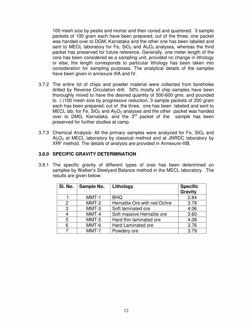
3.8.0 SPECIFIC GRAVITY DETERMINATION 3.8.1 The specific gravity of different types of ores has been determined on
samples by Walker’s Steelyard Balance method in the MECL laboratory. The results are given below:
Sl. No. Sample No. Lithology Specific
Gravity
1 MMT-1 BHQ 2.84 2 MMT-2 Hematite Ore with red Ochre 3.78 3 MMT-3 Soft laminated ore 4.06 4 MMT-4 Soft massive Hematite ore 3.60 5 MMT-5 Hard thin laminated ore 4.08 6 MMT-6 Hard Laminated ore 3.76 7 MMT-7 Powdery ore 3.79

13
3.8.2 However, bulk densities determined by different deposits by various agencies
are also given below:
Determination of Bulk density by GSI in NEB Range
Determination of Specific Gravity by IBM in Ballari – Hospet deposit
Lumpy ore 3.5 Blue Dust 3.8 Mean 3.65
Determination of Specific Gravity by NMDC in Bailadila deposit no.4
Steel grey hematite 4.2 Blue grey hematite 4.0 Laminated hematite 3.5 Lateritic and Limonitic ore 3.5 Flaky ore and Blue dust 3.4 Mean 3.72
Overall Specific Gravity after consideration of all the deposits is 3.50
Ore Zone Hard Ore Soft Ore Powder Ore
I 3.4 3.0 II - - 3.0 III - - 3.0 IV 4.9 3.0 3.0 V 4.7 3.3 3.0
V-A 4.4 3.0 3.0 X 4.35 3.07 3.0
Mean 4.35 3.07 3.0

14

15

16

17

18
CHAPTER-4 4.0.0 MINERALISATION AND CHARACTERISTICS OF IRON ORE 4.1.0 MINERALISATION 4.1.1 All the materials analysing more than 45% and above have been considered as
ore. The ore exhibits vide variations of physical properties ranging from compact, hard and massive ore to soft, flaky, laminated, granular, unconsolidated sandy blue dust or reddish brown powdery ore. Moreover, red ochre occour intermittently in the mine lease area.
4.1.2 However, categorization/classification of ore based on quantitative data helped
in deciphering and delineation of ore such as hard, soft, laminated, powdery etc., have been possible based on mine data (size range or granulometry). It is based on physical properties like colour, presence or absence of weakness, cohesiveness of the grains etc. This lithological classification helped in revealing a stratigraphical picture of the relative preponderance of different ore types.
4.1.3 The iron ore in nature is not homogeneous, but consists of a mixture of many
ore types. Hence, practical approach of demarcating the ore zones based on predominant nature of the lithology/ore substantiated with analytical data have been applied.
4.2.0 TYPE OF ORES 4.2.1 Various types of iron ores are derived from hematite viz. massive ore,
laminated ore and blue dust.
Type of Ore Characteristic Features Lateritic Porous and cavernous in nature
Laminated Closely spaced laminae, which give rise to biscuity ores. Blue dust (-)10 mesh Ore constituting of hematite and martite Massive (Hematitic) No planar structure
4.2.2 The blue dust consists of 10-15% of (-) 100 mesh size fractions and above
80% of (-)100 to (-)325 mesh size. 4.2.3 Besides the float ore gets accumulated along the slope and foot hills which are
of more pure in iron content. In Ballari-Hospet region also the float ore occurs with >64% Fe. The gangue materials are of shale pieces, banded hematite quartzite, dolerite and clay. If lateralization is extensive, the alumina to silica ratio will be high.
Type of Ore Fe% Massive ore(Hematitic) 67.69
Compact laminated ore 67 Powdery ore 65 Laminated ore 65
19
4.3.0 GRADE CLASSIFICATION 4.3.1 The exploration efforts in 70’s were mainly for lumpy ores. Fines were not
given economic importance. Similarly, exploration will also be required to categorize the ore reserves based on end user’s grade classifications. At threshold cutoff of 45% Fe as stipulated by IBM and at 55% Fe cutoff, the mineralized zones within the lease hold area have been delineated and presented in the Table-2 and Table-3 respectively.
Table-2:
DETAILS OF IRON ORE ZONE INTERSECTED IN THE BOREHOLES (AT 45% Fe CUT-OFF)
Bore Hole
Number
From (m)
To (m)
Thickness (m)
True Thickness
(m) Fe% SiO2% Al2O3%
MMT-1 11.50 19.00 7.50 7.05 49.23 25.33 2.04
MMT-1 22.50 30.00 7.50 7.05 45.45 47.01 3.57
MMT-1 30.00 47.50 17.50 16.65 46.40 29.49 3.00
MMT-1 56.50 67.00 10.50 9.87 45.25 31.88 2.18
MMTR-2 0.00 21.00 21.00 19.74 54.12 18.60 1.76
MMTR-2 27.00 39.00 12.00 11.28 54.98 18.49 2.04
MMTR-3 11.00 18.00 7.00 6.58 57.47 14.36 1.78
MMTR-3 18.00 20.00 2.00 1.88 62.68 5.95 2.93
MMTR-3 20.00 36.00 16.00 15.04 59.96 10.48 1.88
MMTR-3 38.00 41.00 3.00 2.82 52.63 18.72 2.97
MMTR-3 41.00 42.00 1.00 0.94 62.54 5.60 3.32
MMTR-3 42.00 51.00 9.00 8.46 48.82 18.50 6.57
MMTR-3 53.00 56.00 3.00 2.82 47.19 16.53 7.91
MMTR-4 0.00 11.00 11.00 10.34 58.45 7.78 4.03
MMTR-4 17.00 20.00 3.00 2.82 47.69 11.31 10.79
MMTR-4 31.00 40.00 9.00 8.46 61.48 3.84 5.10
MMTR-5 49.00 58.00 9.00 8.46 49.46 26.85 1.11
MMT-6 0.00 62.50 62.50 58.75 56.04 11.45 4.24
MMTR-13 4.00 5.00 1.00 0.94 49.70 25.04 3.06
Table-3: DETAILS OF IRON ORE ZONE INTERSECTED IN THE BOREHOLES
(AT 55% Fe CUT-OFF)
Bore Hole Number
From (m)
To (m)
Thickness (m)
True Thickness
(m) Fe%
SiO2%
Al2O3%
MMT-1 22.50 23.00 0.50 0.47 56.82 13.50 3.83
MMT-1 32.00 32.50 0.50 0.47 56.00 16.74 3.06
MMTR-2 0.00 9.00 9.00 8.46 63.32 5.02 2.04
MMTR-2 17.00 18.00 1.00 0.94 55.00 19.01 0.77
MMTR-2 30.00 38.00 8.00 7.52 59.83 12.22 1.53
MMTR-3 13.00 46.00 33.00 31.02 57.33 13.47 2.34
MMTR-4 0.00 9.00 9.00 8.46 62.01 5.43 2.78
MMTR-4 32.00 40.00 8.00 7.52 62.68 3.02 4.66
MMTR-5 54.00 55.00 1.00 0.94 60.84 9.70 2.04
MMT-6 0.00 62.50 62.50 58.75 56.05 11.46 4.29
4.3.2 However, at the planning cutoff of 35% Fe the details of mineralized zone
deduced is given below in Table 4.
20
Table-4: DETAILS OF IRON ORE ZONE INTERSECTED IN THE BOREHOLES
(AT 35% Fe CUT-OFF)
Bore Hole Number
From (m)
To (m)
Thickness (m)
True Thickness
(m) Fe% SiO2% Al2O3%
MMT-1 9.50 67.00 57.50 54.05 40.80 37.66 2.52
MMTR-2 0.00 39.00 39.00 36.66 51.41 23.05 1.77
MMTR-3 2.00 56.00 54.00 50.76 48.56 23.55 3.54
MMTR-4 0.00 40.00 40.00 37.60 36.78 27.89 10.42
MMTR-5 0.00 1.00 1.00 0.94 36.58 40.52 2.55
MMTR-5 9.00 11.00 2.00 1.88 43.20 34.58 1.78
MMTR-5 49.00 58.00 9.00 8.46 49.46 26.85 1.11
MMT-6 0.00 62.50 62.50 58.75 56.05 11.46 4.29
MMTR-10 9.00 10.00 1.00 0.94 35.46 42.12 1.53
MMTR-10 14.00 19.00 5.00 4.70 36.49 42.10 1.84
MMTR-10 42.00 44.00 2.00 1.88 36.02 45.52 2.42
MMTR-10 45.00 46.00 1.00 0.94 36.81 44.32 2.30
MMTR-10 57.00 64.00 7.00 6.58 38.16 44.18 0.77
MMTR-11 52.00 57.00 5.00 4.70 35.51 45.66 2.04
MMTR-11 70.00 71.00 1.00 0.94 35.04 47.36 1.53
MMTR-12 39.00 42.00 3.00 2.82 36.43 46.37 1.28
MMTR-12 44.00 45.00 1.00 0.94 35.25 47.26 1.28
MMTR-12 49.00 50.00 1.00 0.94 35.41 46.94 2.04
MMTR-12 56.00 57.00 1.00 0.94 36.09 45.56 2.55
MMTR-13 0.00 19.00 19.00 17.86 36.23 44.11 2.91
MMTR-14 0.00 70.00 70.00 65.80 38.41 42.19 2.18
MMTR-15 0.00 5.00 5.00 4.70 39.62 35.25 3.62
4.3.3 It reveals from Table 4 that the nature of mineralisation is more consistent at
35% Fe cutoff while the ore nature is siliceous over the entire strike length of 800m in NW-SE direction.
4.4.0 DEPTH PERSISTANCE 4.4.1 The general mode of occurrence of hematite deposits which, form bulk of the
ore reserves/resources in the country, is in the form of surface enrichment. But there are areas like NEB range in Ballari-Hospet, Bailadila Range, Goa, etc., where the ore is in the form of pure sedimentary beds with steep dips ‘reefs’. The average depth of the mineralised zone proved by the present exploration in the present mine lease area of is 58.75 m .The ore body continues even beyond the explored depth.
4.5.0 MINERALISATION FACTOR 4.5.1 Mineralogy of an iron deposit has a great influence in the ore treatment
characteristics and economics. Magnetite is recoverable by relatively simple, economical magnetic separation while, hematite, goethite, siderite require expensive roasting or flotation processes. Although when the grains are
21
coarse, hematite ore may get treated with low cost. Mineralisation factor is the ratio of net ore bearing area to gross area. It is referred as the co-efficient of impurities. The mineralized area for M/s Mineral Miners and Traders Mine Lease Area (M.L.No.2185A) is 0.0456 km2 out of total area of 0.4610 km2. Hence, the mineralisation factor is 0.01.
4.6.0 PHYSICAL CHARACTERISTICS OF ORE 4.6.1 The ore are massive + laminated, soft laminated, blue dust, lateritic and
powdery. 4.6.2 Principal ore minerals are hematite + magnetite, goethite and limonite. The
iron content ranges from 62.7% to 65.5% in blue dust. 4.6.3 Besides lumpy ore and soft laminated ore, rarely blue dust occurs in M/s
Mineral Miners and Traders Mine Lease Area (ML No. 2185A). 4.7.0 CHEMICAL CHARACTERISTICS OF THE IRON ORE 4.7.1 In the entire deposit, the high grade ore is almost free from lateralization and
the laterite area is very less (2-3%), whereas the blue dust area ranges about 10-15%. However, the blue dust mostly contains more hematite; therefore, good quantity of hematitic ore could be easily available from the blue dust. The hematitic ore persists even beyond the level of exploration as could be visualize from the geological cross sections.
4.7.2 Silica to Alumina ratio ranges between 1.13 and 24.18 with the average of 8.72
indicating low level of lateralization; whereas the Iron to Alumina ratio ranges from 4.67 to 44.56 with average of 19.85 for the M/s Mineral Miners and Traders , Mine Lease Area (ML No. 2185A). The ore in general, is rich in iron [>56%Fe], but they also contain 6.12% Al2O3.
4.7.3 Owing to the association of iron bearing minerals more with laterite and clayey
gangue than with siliceous minerals, the alumina to silica ratio is generally greater than one.
4.8.0 ORE BODY DIMENSION 4.8.1 At 45% Fe cut-off, the geometry of the iron ore bands deduced is given below.
Dimension
Trend NW-SE/Steep easterly dip
Strike length (m) 397.50m (S4,S7-S11)
Av. Wide area (m) About 450m (Main Band)
Av. True thick (m) 17.29m

22
The iron ore band persists even beyond the explored depth is evitable as could be visualized from the geological cross sections S-4, S-8 & S10.
4.8.2 The mines lease area extends over the strike length of about 800m in NW-SE
direction amidst wide area of about 450m. A BHQ band of 85m to 105m wide runs northeastern side of the iron ore band over about 800m strike length in NW-SE direction. Besides, a few more BHQ bands occur intermittently in the western side of the lease area. The red ochre occur intermittently with the exception of MMT-1 wherein the ore potential is 0.020 million tonnes with the grade of 45.45% Fe, 47.01 SiO2 and 3.57 Al2O3.
4.8.3 A critical study of the behavior of the ore body along NW-SE reveals that in the
mine lease area, the ore band extends further northwestly beyond the lease area (MMTR-2).

23
CHAPTER-5
5.0.0 METHOD OF RESOURCE ESTIMATION 5.1.0 RESOURCE ESTIMATION BY GEOLOGICAL CROSS-SECTION 5.1.1 Ore reserves /resources have been estimated by geological cross section
method. In order to delineate the ore and non-ore, the grade or threshold value of 45% Fe has been adopted, thus non ore above and below ore zones has been demarcated. The rule of gradual change or law of linear function has been applied [Constantine C. Popoff, 1965] along with the rule of nearest points for application of influence of half way between successive boreholes.
5.1.2 At threshold cutoff of 45% Fe as stipulated by IBM, the mineralized zone within
the lease hold area, the ore reserves are estimated. 5.1.3 A total of 11 cross sections has been prepared along N45°E – S45°W serially
numbered S1 – S1’ to S11 – S11’ of the mine lease (Plate-V A-D) based on the interpretation of sub surface borehole qualitative data along with surface geological data which is perpendicular to general strike of the ore body. A typical geological cross section along S4-S4’ is given as Text Plate-2.
5.1.4 50.0m on either side of the iron ore intersection of the borehole has been
placed under (G1) and the next 50m under (G2) category of UNFC. 5.1.5 Correction factor of 1.064 for Thickness of Iron ore in strike direction has been
applied. Similarly a correction factor of 0.94 has been applied to get true thickness.
5.1.6 A call factor of 10% reduction has been applied to calculate net geological
reserves. 5.2.0 SHAPE OF THE ORE BODY 5.2.1 The shape of the ore body on the cross section line has been obtained by
interpretation and correlation of the borehole data. Each borehole gives a point for the location in space of the ore bottom which, in general is BHQ or siliceous ore.
5.2.2 The possibility of the ore body being in the nature of ore folded sedimentary
bed, behaving as a stratigraphic unit was considered. The alternative hypothesis of the ore body, being a leached and replaced portion of some pre-existing rock, in this case the BHQ, appeared to be more realistic and adopted for determination of the ore bottom configuration. The ore bottom was out-lined by joining intersection on adjacent boreholes through smooth lines, though these lines may cut across the general dip of the formation.
5.2.3 The shape of the non ore consisting essentially of BHQ at times ferruginous
clay has been ascertained by joining the upper limit of the ore zone [>45% Fe]
24
in adjacent boreholes. However, in certain cases the thickness of non ore zone [< 45% Fe] is negligible, while in other sections it is considerable. Or else, the iron band / lens are different one.
5.2.4 The intercalation of ferruginous clay, clayey iron ore and remnant BHQ in the
ore body has been impersistent. 5.2.5 Influence of each cross section has been taken up to half the distance following
“rule of gradual change” and “rule of nearest point”. However at the extreme end of the area of exploration (S1-S1’ and S11-S11’) sectional influence up to buffer zone of mine lease area (7.5m from mine lease boundary) has been considered.
5.3.0 ESTIMATION OF RESERVES AND GRADE 5.31 After delineating the limit of non ore (<45%) and boundaries of different litho-
units, the geometry of the ore body have been demarcated. Thus, the sectional area or volume has been computed by the software using AutoCAD.
5.3.2 Ore resource tonnage has been estimated by multiplying the volume with the
tonnage factor of specific gravity of 3.50. The sum has been considered as geological in-situ reserves.
5.3.3 At the back drop of iron ore extraction from the Sandur schist belt of Ballari –
Hospet area since independence has been quite predominant. Moreover iron ore has been extracted from Kumaraswamy range not only by NMDC but also by SMIORE. However, Dalmia International had extracted the ore from NEB range for export for quite sometime.
5.3.4 The UNFC code pertains to geological axis of (G1) and (G2) have been
assigned. The reserves estimated by cross section method at 45% Fe cut off are given in Table 5 of mine lease area.
5.3.5 It reveals that the ore body has the extension of about 397.50m in strike length
along the NW-SE with an average wide area of 300-450m. A total 9.224 m.t. of net reserves with average grade of 53.26 % Fe, 19.80 % SiO2 and 6.12% Al2O3 have been estimated
5.4.0 SECTIONAL RESERVES 5.4.1 The Succinct details of sectional reserves pertaining to the mine lease area are
given in Table 6. 5.5.0 RICE RATIO 5.5.1 Fe: SiO2 + Al2O3 is 2.63 for lease hold area. The SiO2: Al2O3 ratio is 8.72 and
Fe : Al2O3 19.85.

25

26
Table No. 5 Estimation of ore reserves by cross section method
Minerals Miners and Traders Mine Lease Area ML. No. 2185 A
Serial No.
Section Number
Borehole Number
Intersection (m) Diff (m)
True Width
(m)
Average Sectional Influence
(m)
Area (Sq. m)
(1)
Area (Sq. m)
(2)
Reserves (Tonnes)
(G1)
Reserves (Tonnes)
(G2)
Total Reserves (Tonnes)
Grade %
From To Fe SiO2 Al2O3
1 S4-S4' MMT - 1
11.50 19.00 7.50 7.05 36.00 755.19 734.07 95169.316 92507.430 187676.746 49.23 25.33 2.04
22.50 30.00 7.50 # 7.05
36.00 696.52 1656.26 87776.116 208721.848 296497.964 45.45 47.01 3.57
30.00 47.50 17.50 16.65 36.00 1804.35 1753.97 227384.803 221035.429 448420.232 46.40 29.49 3.00
56.50 67.00 10.50 9.87 36.00 1056.37 1413.20 133124.231 178091.551 311215.783 45.25 31.88 2.18
Influence 36.00 4915.63 0.000 619468.555 619468.555 45.25 31.88 2.18
Sub Total 1863279.280 45.96 33.05 2.58
2 S7-S7' MMTR - 05 49.00 58.00 9.00 8.46 35.00 885.91 302.40 108541.229 37050.221 145591.450 49.46 26.85 1.11
Sub Total 145591.450 49.46 26.85 1.11
3 S8-S8' MMT - 06 0.00 62.50 62.50 58.75 43.50 4679.50 3108.52 712567.639 473347.559 1185915.198 56.04 11.45 4.24
Influence 25.00 43.50 3210.13 0.000 488820.202 488820.202 56.04 11.45 4.24
Sub Total 1674735.400 56.04 11.45 4.24
4 S9-S9' MMTR - 04
0.00 11.00 11.00 10.34 54.00 710.54 524.94 134314.397 99229.931 233544.329 58.45 7.78 4.03
17.00 20.00 3.00 2.82 54.00 320.03 324.48 60495.026 61336.494 121831.521 47.69 11.31 10.79
31.00 40.00 9.00 8.46 54.00 903.58 868.42 170803.623 164157.017 334960.640 61.48 3.84 5.10
Sub Total 690336.489 58.02 6.49 5.74
5 S10-S10' MMTR- 03
11.00 36.00 25.00 23.50 106.50 2477.07 2370.25 923475.799 883650.819 1807126.618 59.48 11.20 1.94
38.00 51.00 13.00 12.22 106.50 1285.46 1264.58 479230.165 471446.683 950676.847 50.75 17.56 5.49
53.00 56.00 3.00 2.82 106.50 299.66 296.18 111714.720 110420.437 222135.157 47.19 16.53 7.91
Influence 10.00 106.50 1819.23 0.000 678226.519 678226.519 47.19 16.53 7.91
Sub Total 3658165.141 54.19 19.85 11.61
6 S11-S11' MMTR - 02
0.00 21.00 21.00 19.74 122.50 1854.20 880.16 795114.205 377428.979 1172543.184 54.12 18.6 1.76
27.00 39.00 12.00 11.28 122.50 1194.31 1239.79 512144.186 531645.441 1043789.627 54.98 18.49 2.04
Sub Total 2216332.811 54.53 18.55 1.89
Total 10248440.569 53.26 19.80 6.12
Geological Insitu Reserves 10248440.569
53.26 19.80 6.12 Net Reserves (tonnes) 9223596.513
Net Reserves ( million tonnes) 9.224
#- Reserves of Red Ochre
27
Table No.6 Summary of Sectional Reserves (M.L No.2185A) (section S4 & S7 - S11)
Section Number
Sectional Reserves
Fe SiO2 Al2O3
S4-S4' 1863279.28 45.95946762 33.05266756 2.58442784
S7-S7' 145591.4497 49.46 26.85 1.11
S8-S8' 1674735.4 56.04 11.45 4.24
S9-S9' 690336.4895 58.02125774 6.491237683 5.74219251
S10'-S10' 3658165.141 54.18779953 19.85062736 11.6122916
S11-S11' 2216332.811 54.52501998 18.54819512 1.89186697
Geological In Situ
resources 9223596.51 53.26 19.80 6.12

28
CHAPTER-6
6.0.0 RELIABILITY OF ESTIMATION 6.1.0 FREQUENCY DISTRIBUTION 6.1.1 The entire primary sample data and sample data within the ore zone (>45% Fe)
have been subjected to statistical evaluation, the frequency distribution is highly skewed as could be seen from the Text Plate-3 to 8.
The statistical parameters estimated for primary sample (845 nos) data is as follows:
Parameter Fe SiO2 Al2O3
Mean 27.00 29.00 7.20
Standard deviation 0.69 0.071 0.254
Variance 0.004 0.005 0.06
Sichel’s “T” estimator 1.000 1.000 1.030
The statistical parameters estimated for Zone data (159 nos) data is as follows:
Parameter Fe SiO2 Al2O3
Mean 51.00 14.00 2.60
Standard deviation 0.030 0.101 0.215
Variance 0.0009 0.010 0.046
Sichel’s “T” estimator 1.000 1.010 1.030
6.2.0 ACCURACY OF ANALYTICAL PROCEDURE 6.2.1 Grade: The grade estimates of the deposit are based on the results of core
samples. Each sample undergoes the process of sample preparation and analysis. Since, sampling and analysis are two complimentary links of quality estimation chain, the possible source of errors, if any, could be from the bias in sample preparation and inaccuracies in assaying or both.
6.2.2 Mean: The mean value obtained by statistical method as well as calculated
values for three variables is given below:
Parameter Fe SiO2 Al2O3
Estimated 53.26 19.80 6.12
Sichel’s “T” estimator 52.00 15.010 3.63

29

30

31

32

33

34

35

36

37

38
CHAPTER-7
7.0.0 CONCLUSIONS AND RECOMMENDATIONS 7.1.0 CONCLUSIONS 7.1.1 M/s Mineral Miners and Traders Mine Lease Area (M.L.No.2185A) is located
on the Janikunta range, Sandur schist belt in NW-SE direction, having Longitudes 76º46’57.01” and 76º46’53.10” and Latitudes 15º07’06.02” and 15º06’35.70”. The mine lease area is located at about 5km from Haraganadoni. The deposit extends over 397.50 m strike length within the extent of about 450m across strike.
7.1.2 Physically, the iron ore ranges from haematitic ore to soft laminated, powdery,
blue dust. Siliceous ores have also been noticed. However, the red ochre occur intermittently with the exception of MMT-1 wherein the ore potential is 0.020 million tonnes with the grade of 45.45% Fe, 47.01 SiO2 and 3.57 Al2O3.
7.1.3 The rocks exposed are typical iron formations namely the haematitic ore, blue
dust, powdery ore, clay minerals and BHQ. Predominant ore mineral is hematite and limonite and goethite to some extent. The important non ore consists of remnants of banded hematite quartzite with meta basalt and occasional ferruginous quartzite.
7.1.4 Ore body looks like an elongated band with the ore body continues beyond the
explored depth for about 30-50m depth. The band also extends well over the lease area with the same quality (MMTR-2)
7.1.5 The iron ore band persists even beyond the explored depth is evitable as could
be visualized from the geological cross sections S-4, S-8 & S10. 7.1.6 Based on the estimation by geological cross section method, the net in-situ
reserves is 9.224 m.t. of net reserves with average grade of 53.26 % Fe, 19.80 % SiO2 and 6.12% Al2O3 have been estimated. The Rice ratio for the mine lease area is 2.63.
7.2.0 RECOMMENDATION 7.2.1 M/s Mineral Miners and Traders Mine Lease Area (M.L.No.2185A) has good
potential that would be amenable to systematic scientific mining.

39
References:
1 Document on strategy for exploration exploitation and development for Iron
Ore in India.
Sub group on Iron Ore, Government of India, MOM,
Jan-2006
2 Preliminary appraisal of the Ballari Hospet Iron Ore Deposits, Ballari Division, Mysore.
K. Ganeshan and R.C. Vidyarthi, IBM, Nagpur,
March-1964
3 Archaean Greenstone belts of South India
B. P. Radhakrishna
M. Ramakrishnan
Geological Society of India, Bengaluru, 1990
4 Geology of Karnataka BP Radhakrishna
R. Vaidyanathan
Geological Society of India
5 Computing reserves of Mineral deposits : Principles and Conventional methods
Constantine
C.Popff
USBM, 1965
6 Economic Mineral Deposits
Revised Edition
Mead L.Jensen and Alan M.Bateman
John liley and Sons New York 1951
7 Economic Evaluation of Mineral Property
Sam
L. Vanlandangham
Huchinson Press Publishing Co. Pennsylvania 1983
8 Geo-statistical Ore Reserve Estimation
M. David Elsevier Scientific Publishing Co. Netherlands, 1977
9 Exploration Report Far Eastern section BRH Iron Ore Mine, Dist. Ballari, Karnataka
MECL,
Sept, 1996
10 Exploration Report Bailadila Iron Ore Deposit No.4
NMDC, Hyderabad, Andhra Pradesh
11 Exploration Report Rowghat Iron Ore Deposit ‘F’, Block-A Phase-I, Dist. Bastar, Madhya Pradesh
MECL, Dec, 1991
12 Exploration Report Chiria Iron Ore Deposit, Phase-I, Dist. Singhbhum, Bihar
MECL, March, 1974
13 Vison 2020 IBM
14 Mineral Year Book 2012 IBM
15 Special Issue on Iron Ore Future- Next Decade
Journal of Mines, Metals and Fuels
Mar/Apr-2010
40
PERSONNEL ASSOCIATED 1. Overall Guidance
Shri S.K. Thakur General Manager (Exploration)
2. Monitoring and Co-ordination
Shri S.K. Thakur
Shri D.Mohan
General Manager (Exploration)
Sr. Manager(Geology)
3. Physical Execution of work
Shri P.Sekar
Shri S. Satpathy
Shri Sandeep Sarangi
Shri Akhil Kumar Dwivedi
Shri A.K. Ghosh
Shri S.N. Dhyani
Shri H. R. Mallick
Shri N. Gasal Khan
Sr. Manager(Geology)
Sr. Geologist
Geologist
OT (Geology)
ASMO
ASMO
Sr. Survey and Map Officer
Sr. Drilling Engineer
4. 5.
Geological Mapping Shri S. Satpathy Sr. Geologist Data Processing and Documentation
Dr. S.Kamalakaram
Shri J.Narayana Moorthy
Shri Akhil Kumar Dwivedi
Sr. Manager (Geology)
Sr. Manager (Geology)
OT (Geology)
6. Chemical Laboratory, MECL, Nagpur
Shri PC Khot Manager (Lab.)
7. Petrological Laboratory, MECL, Nagpur
Shri Sayantan Pal
Dr. Anjani Kumar
Geologist
Sr. Manager (Geology)
8. IT Centre
Shri ADP Rao
Shri B. Umapathy
Shri K.K. Kaushik
Shri Rahul Mathankar
Shri Philip Varghese
Sr. Manager (Systems)
Sr.Manager (Geology)
Sr.Manager (Geology)
Sr. Programmer(Systems)
Sr. Console Operator