Embed Size (px)
Citation preview
MMAAGGAAZZIINNEE OOFF TTHHEE
GGEEOOLLOOGGIISSTTSS’’
AASSSSOOCCIIAATTIIOONN
VVoolluummee 1144 NNoo..11 MMaarrcchh,, 22001155
Once & Future extractive Industries | Did the Earth Move for you? | Gems of the South Downs | Grange Top Quarry; Ketton | Crossword |
Once & Future extractive Industries | Did the Earth Move for you? | Gems of the South Downs | Grange Top Quarry; Ketton | Crossword |
20084 GAMag March 2015 TOP COPY 26022015.qxp_mag41.qxd 05/03/2015 16:16 Page 1

Published by:
The Geologists’ Association. Four issues per year. ISSN 1476-7600
Production team: LIAM GALLAGHER, John Crocker,
John Cosgrove.
Printed by City Print (Milton Keynes) Ltd
The Geologists’ Association
Founded in 1858 The Geologists’ Association serves the
interests of both professional and amateur geologists, as well
as making geology available to a wider public. It is a national
organisation based in London, but is represented by local and
affiliated groups around the country. The GA holds monthly
lecture meetings, publishes a journal and geological guides
and organises field excursions both in the UK and abroad.
Subscriptions are renewed annually on November 1. You can
join the GA on-line on our website:
www.geologistsassociation.org.uk/JoiningtheGA.html
By phone 020 7434 9298 or by post to Sarah Stafford,
Executive Secretary, The Geologists’ Association, Burlington
House, Piccadilly, London W1J 0DU.
© The Geologists’ Association.
All rights reserved. No part of this publication may bereproduced, stored in a retrieval system or transmitted, inany form or by any means, without the prior permission in
writing of the author and the Geologists’ Association.
LAST Copy dates for the Circular & Magazine:
March Issue: January 13
June Issue: April 21
September Issue: July 21
December Issue: October 20
Items should be submitted as soon as possible and not
targeted on these dates.
We welcome contributions from Members and others.
Magazine of the Geologists’ Association Vol. 14, No.1 2015
Magazine of theGeologists’ Association
Volume 14, No 1March, 2015
The GEOLOGISTS’ ASSOCIATION does not accept any
responsibility for views and opinions expressed by
individual authors in this magazine.
CONTENTS
3 From the President
4 Report from Council
6 Evening Lecture December, 2014: A once and
future extractive history of Britain:The rise, fall
and resurgence of UK domestic mineral supply:
Andrew Bloodworth
7 Evening Lecture January, 2015:Did the Earth move
for you? From Great Earthquakes to Silent Slip: Dr
Rebecca Bell
9 Field Meeting: Geological gems of the South
Downs - Leader Rory Mortimore; Report by:
Grahame Mayo
12 Obituary: Hugh Prudden
13 Field Meeting Report:Hanson Heidelberg
Cement’s “Grange Top" Quarry at Ketton - Leader
Peter del Strother; Report by: Richard Trounson
15 Circular
20 Rockwatch News
21 Curry Fund Report
23 Crossword
WEBSITE ONLY EDITION
25 BOOK REVIEW: The Geology of the Isle of Man
By: Stephen F. Crowley
27 Festival of Geology 2014; Field Excursions; Report
by: Diana Clements
28 Obituary: Eileen Bennett
28 Field Meeting Report:Lisbon Museums -
Leader: Prof. Miguel Ramalho & Joanna Reis;
Report by: Richard Trounson
31 Field Meeting Report:Lisbon Peniche Coast -
Leader: Dr. Luis Duarte; Report by: John Lonergan
32 Field Meeting Report:Lisbon The Lines of Torres
Vedras - Leader: Paulo Ferreira; Report by: Barry
Hall
33 Obituary: Christopher King
35 Field Meeting: New Zealand - Auckland to
Christchurch - Leader: Dr. Mike Ridd; Report by:
Daniel Stedman; Photos by Mike Ridd
Curry Fund Dates for 2015
Application deadline Committee date February 20 March 13May 20 June 12August 20 September 11November 20 December [email protected]
Research Awards Deadlines
15 November 2015 [email protected]
2
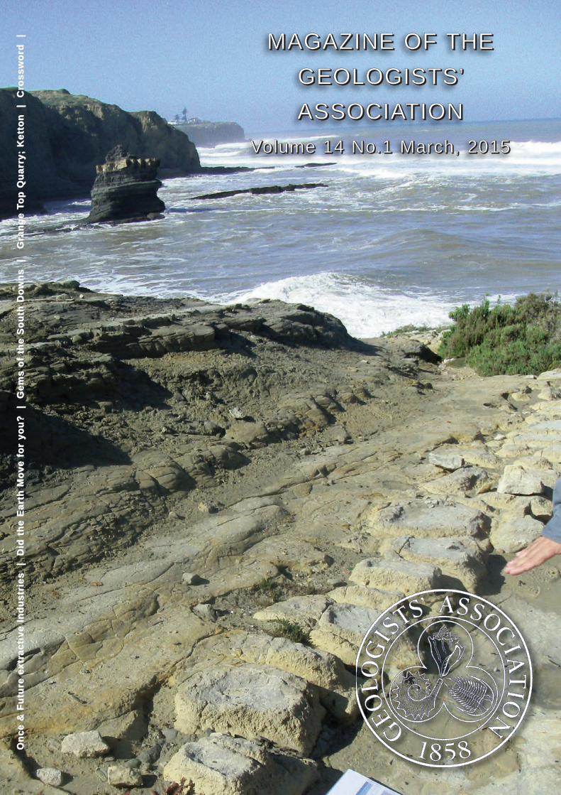
Cover picture
Toarcian GSSP* candidate (to the left of leaflet) near
Peniche, Portugal.
* = Global Boundary Stratotype Section and Point
20084 GAMag March 2015 TOP COPY 26022015.qxp_mag41.qxd 05/03/2015 16:16 Page 2
I’m writing this from Watford General Hospital which is
making my GA life difficult. The Christmas period is always
quiet for the Association, so it’s just as well my absence isn’t
too crucial.
What this situation has proven is that the Association has
such a strong and closely working executive that even when
the President is indisposed for a while, cover is moved into
place and all the functions of the Association continue without
any obvious break in
continuity. So my first
message for 2015 is a
massive thank you to the GA
council for all they do, even if
I get taken out of action for a
short while. The second New
Year message is a clear one
– to an already strong
council we are already
adding to and refreshing
some of the Council at the
May AGM and the members
coming forward are so
enthusiastic and full of ideas
that we can rest assured that
the future of the Association
is as strong as ever as it
moves into its 157th year.
This is also my first opportunity to look at the programme
we have lined up through the year and our thanks go to Mick
Oates for putting much of this together. Even from Norway
Mick manages to collate a really substantial programme
together for us. I unfortunately missed Rebecca Bell’s
January lecture due to my enforced absence but I’ll certainly
try to follow it up on line. Hopefully I might be able to make
the February meeting at which Alexander Liu is taking a
completely new look at the Ediacaran fauna. So much new
information is coming from related sites in China and
Greenland that the relationships of early Cambrian faunas are
under major revision.
March sees Dave Martill and Steve Etches looking at the
Kimmeridge Clay food chain. Both know their material so well
and how to present it that we’re in for a real treat at this
meeting. Marcella Ruta is showing us “How life bounces back
after an extinction” which is always of interest, as so
frequently much attention is put into what leads up to an
extinction, whereas the immediate recovery period
afterwards is so much more important.
This brings me to the May Presidential address and
originally I was tempted to follow on from the Mortimore
theme of chalk and flints and extend these sediments into the
deeper waters of the North Sea Basin. However, an excess of
the white stuff can be a bad thing (for some) so I’ve decided
to introduce you to the wonders of foraminifera and how
these single celled organisms can provide us with so much
useful information.
When I was given the opportunity to teach the Foraminifera
module on the University of Birmingham Applied and
Petroleum Micropalaeontology MSc three years ago, for the
first time in my life I was forced to sit down and re-assess
what we know and what we don’t about these remarkable
organisms. Having worked with them over the last forty
years, I began to realise that some of the driving forces
behind the evolutionary trends we see had not really been
brought together. When you integrate this information some
remarkable patterns begin to
emerge. I’ve started to
become more and more
fascinated with this and I
hope I can prove to you that
single celled microfossils can
tell us so much more than
we ever expected.
Later in the year there is a
swing more toward William
Smith – no surprise there in
this bicentennial year. Mike
Rumsey provides an initial
link by talking to us about
“Unusual minerals in the
Mendip Hills”, an old
stomping ground for Mr.
Smith and then more directly
in July Tom Sharpe addresses
the subject of “Mr. Smith’s remarkable maps.” If you get
opportunity this year to see copies of the Smith maps close
up as they’re brought out of their closets, make sure you do.
The colours are so vivid and the accuracy of the boundaries
so tight that you can only be impressed. Finally in October we
have Dr. Chris Jackson looking at that most mobile of rocks,
Salt and in December we follow this with an in depth look at
the impact of the Icelandic volcano and it’s ash by Helen
Dacre.
You’ll also see a theme of building stones through the year
both in our field trips and in our annual conference which this
year is being held at the BGS in Keyworth. So frequently we
take building stones for granted, when so much time and
effort goes into their choice and so much information can be
gleaned from what they can tell us, so all these will be well
worth attending.
All in all, both the lecture and field trip programmes are
really strong allowing you to make the most of geology across
the country. Speaking of which we’re also kick starting the
Geolab programme this year in Sussex in March. This is
targeting absolute beginners in geology providing
introductory talks and field visits for a day and hopefully this
will enthuse attendees sufficiently so that they decide that
earth sciences is a subject they liked to learn so much more
about. Other Geolab locations across the country will be
targeted later in the year, so if your local society wants to
host one of these don’t hesitate to drop me a note on
Enjoy your geologising in 2015.
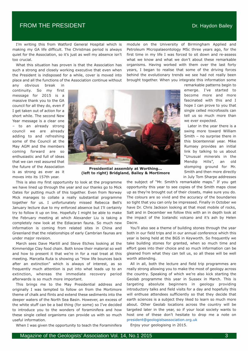
FROM THE PRESIDENT Dr. Haydon Bailey
Magazine of the Geologists’ Association Vol. 14, No.1 2015 3
Presidential assembly at Worthing...
(left to right) Bridgland, Bailey & Mortimore
20084 GAMag March 2015 TOP COPY 26022015.qxp_mag41.qxd 05/03/2015 16:16 Page 3

By the time you read this the Annual General Meeting will
soon be upon us again. Many thanks to all those who have
written with nominations for new council members and for
the Halstead and Stopes Medals. The Awards will be
presented at the AGM on 1st May, 2015. As for all the talks
this year it will begin at 6.30 pm. The cost of the ANNUAL
DINNER will remain at £35. Do come to this most enjoyable
social event held in the Lower Library after the meeting.
Please find booking details on page 22.
The Annual Report will be
sent out in April. The
electronic version with colour
photographs will be sent to all
those members for whom we
have email addresses so
please send updates to Sarah
Stafford if you think she may
not have it. Paper copies will
be sent to those not on email
and to anyone who tells Sarah
they would rather the paper
version (black & white). The
mailing will include the new
2015/16 password for access
to the Members page on the
GA website where GA lectures
can be viewed. We are now
regularly emailing our
members about events and
also links to the electronic
version of the GA Magazine. Everyone is also sent a paper
copy unless you tell Sarah you would prefer not to in which
case you will save money for the GA.
The GA conference in 2015 is on building stones with the
title Building our future. It will take place at the BGS in
Keyworth, Nottingham on Friday 9th October with field trips
on Saturday 10th. Please see the back cover for details and
look for the booking form on the back of your address label.
We hope to see many of you there but do spread the word as
you do not have to be a GA member to attend. Our other big
event is the GA Festival of Geology which this year will be
held on Saturday 7th November with Festival walks on
Sunday 8th. The GA and Rockwatch will again be visiting the
Lyme Regis Fossil Festival, held on 1-3 May. The Friday,
schools’ day, clash with the GA AGM was unavoidable this
year. If you have never been to the Lyme Regis Festival it is
strongly recommended. This year’s theme is Mapping the
Earth in honour of the bicentenary of William Smith’s first
geological map of England and Wales, published in 1815. We
have two William Smith events of our own: the talk by Tom
Sharpe on 3rd July and the trip to Bath with Hugh Torrens.
I am pleased to say that we sold out of the GA calendars
we produced, featuring entries in our photographic
competition. Next year we will organise it differently so that
the deadline is earlier and we can have the calendars ready
for sale at the GA Festival in November. When you are out on
trips through the summer, please remember to select your
best photographs with that in mind. A form will be placed on
the website under the GA
Festival in due course.
The GA was out in force to
support the conference
Geology and History in
Southeast England in
Worthing College on 29th
November organised by Tony
Brook and the West Sussex
Geological Society. Two of our
past presidents, Rory
Mortimore and David
Bridgland were speaking and
our current president, Haydon
Bailey wrote a foreword to the
excellent abstract booklet and
also came to the meeting. The
GA Guides proved popular and
we sold out of GA calendars.
The conference was truly
collaborative. Other supporters were the Brighton and Hove
Geological Society and the History of Geology Group and the
talks ranged through archaeology, building stones, history,
detective stories as well as the underlying geology of the
Weald. Congratulations to the organisers for gathering
together such an excellent and varied team of speakers which
attracted a large number of delegates.
At the December Council Meeting we welcomed Richard
Pollock as a co-opted member of Council. With the expertise
he has gained as chairman of the Bath Geological Society we
hope he will be able to help us with sponsorship and
marketing. We were also pleased to welcome Reading
Geological Society as a Local Group as they now have 12 GA
members. However, we are sad to report that both the
Ravensbourne Geological Society (Local Group) and
Southampton Geology Group, (Affiliated Society) are unable
to continue.
Our GA Facebook now has over 5000 followers. Many
thanks to Leanne Hughes (Vice President), who has been
facilitating this. She is now considering starting a blog.
REPORT FROM COUNCIL Diana Clements, General Secretary
Magazine of the Geologists’ Association Vol. 14, No.1 20154
Tony Brook introducing the speaker to a packed audience in the Exhibition Hall of Worthing College
20084 GAMag March 2015 TOP COPY 26022015.qxp_mag41.qxd 05/03/2015 16:16 Page 4
We welcome the following new members to the Geologists’ Association:
Elected December 2014 - February 2015
Mr Paul Ballantyne Dr Rebecca Bell Mr David John Bowell Mr Christian Chefdeville
Mrs Sandy Coates Mrs Barbara Kleiser Mr Stephen Locke Ms Lisa Millar
Mr Gordon Neighbour Mr Mark Rayner Mr Graham Reeve Mr Cliff Spooner
Mr Sam Walker Miss Emma Willmot
Magazine of the Geologists’ Association Vol. 14, No.1 2015 5
Deaths: During the past three months we have been made aware of the following deaths of members:
Eileen Bennett Frederick Imm Christopher King Norman le Roux
Mrs Mollie M. Owen William Prewett Hugh Prudden
An obituary for Chris King appears on page 33. An obituary for Hugh Prudden appears on page 12.
An obituary for Eileen Bennett appears on page 28.
Please notify us of any members that have died that you are aware of. We are always keen for short obituaries and/or a
photograph so if you feel you would like to write one, please get in touch with the office.
GA COUNCIL
Officers: President: Dr Haydon Bailey; [email protected]
Senior Vice-President: Professor Rory Mortimore (with responsibility for External Affairs)
Vice Presidents: Professor John Cosgrove (with responsibility as GA Magazine representative),
Miss Leanne Hughes (with responsibility for website oversight and social media);
Treasurer: Dr Graham Williams;
General Secretary: Mrs Diana Clements;
Co-opted to Executive: Dr Colin Prosser (Chairman of Publications Committee).
Postholders: Minutes Secretary: Barbara Cumbers;
Meetings Secretary: Dr Michael Oates;
Field Meetings Secretary: Mr Geoff Swann; [email protected]
Overseas Field Meetings Secretary: Dr Ian Sutton;
Guides Editor: Professor Susan Marriott;
GA Magazine Editor: Dr Liam Gallagher, [email protected]
Earth Heritage Representative: Professor David Bridgland;
GA Archivist: Dr Jonathan Larwood;
Librarian: Sara Osman;
Awards Panel Secretary: Mrs Barbara Cumbers; [email protected]
Membership Team Chairman: Dr Paul Olver;
Rockwatch Chairman: Mrs Susan Brown; [email protected]
Non-Council Postholders: Proceedings Editor: Professor Jim Rose.
Executive Secretary: Sarah Stafford; [email protected]
Ordinary Members of Council: Mr Anthony Brook, Ms Sandy Colville-Stewart; Ms Nikki Edwards, Anjana Ford; Roger Le Voir, Gerald Lucy,
Paul Winrow. Co-opted: Professor Richard Howarth & Richard Pollock
ELECTRONIC VERSION OF THE GA MAGAZINE
As well as paper copies, an electronic version of the March GA Magazine has been sent to all those members for whom
we have an email address. If you did not receive it and would like to, please contact the office with your email address:
For future editions only the electronic version will be sent to students and young people under 25 who pay a reduced
subscription. We would be delighted if other members volunteer to receive the magazine in electronic format only. Please
tell the office if that would suit you. Everyone else will continue to receive paper copies as well as the electronic version.
The latest issue will also be on the Members Only page of the website: www.geologistsassociation.org.uk/membersonly.
If you do not know the new user name and password, please enquire from the office.
20084 GAMag March 2015 TOP COPY 26022015.qxp_mag41.qxd 05/03/2015 16:16 Page 5

Magazine of the Geologists’ Association Vol. 14, No.1 20156
Evening Lecture: A once and future extractive history of Britain: December, 2014The rise, fall and resurgence of UK domestic mineral supply
By: Andrew Bloodworth, British Geological Survey
The Director of minerals and waste
research at BGS wanted to tell a story that
has largely been forgotten about - the long
history of mining and minerals extraction in
Britain and what it can tell us about the
future and put this in a global context.
Things changed in the 20th century and
minerals extraction is now a very small part
of our economy after dominating it in the
18th and 19th centuries.
Postcard from the edge
Britain is so well endowed with minerals
because it has been on the edge of the
European continent for many millions of
years, leading to a rich and varied geology. It
was also on the edge of ice sheets, leading to the deposits of
sand and gravel so useful in the construction industry.
Industrial-scale development of mining developed here
before it did in other countries because many of the resources
are co-located. For example, the West Midlands, South Wales
and the Midland Valley of Scotland have all the ingredients for
iron smelting, iron ore, coal and limestone as well as fireclay
to line the furnaces, in some cases from the same shaft. In
addition, the British climate and its island nature catalysed
the transport of minerals by inland and coastal navigation. It
is a relatively populous island, which has always looked
outwards as a trading country. In the late 18th and 19th
centuries it was one of the most important mining countries
in the world but this impact is largely forgotten.
In the Bronze Age, copper was common in Europe but tin
was not so the ancients went to the ‘tin islands’ (Cornwall)
from about 2,000BC. The Greeks, Phoenicians and Romans
all came to trade. Today almost all the big mineral companies
have become foreign-owned and even in the past, the trade
in tin was controlled by a tribe from Brittany.
In the Middle Ages, there was a thriving trade in stone for
the construction of high-status buildings. In the 14th century,
for example, limestone was transported by “barge, ship and
creaking carts” from Ancaster, Lincolnshire, to build Norwich
churches.
In the 17th and 18th centuries, Britain’s rise as a global
power was pioneered by copper. Sheathing protected Royal
Navy ships from fouling, meaning that they were faster, more
manoeuvrable and able to stay at sea longer than other
ships. A 74-gun frigate required 14 tons of copper for
sheathing.
Jurassic sedimentary iron ores were mined extensively in
Northamptonshire, Leicestershire and Lincolnshire from 1880
to 1980. Steel-making technology to deal with high
phosphorus ores such as these dictated both resource
development and its demise. British iron was a vital and
secure resource through two World Wars, enabling ships to
transport other needed goods.
Ascent, decline and fall
During the 19th century, technological development (steam
pumping to dewater mines, canals and
railways for bulk transport) and scientific
understanding drove supply, access, recovery
and demand for minerals. In the 20th
century, economies of scale and global
logistics impacted on supply while technology
and social change impacted on demand. In
the mid-19th century, Britain was the world’s
largest producer of copper but steamships
enabled fast, reliable transport of materials
by sea and allowed the use of lower-grade
deposits that were easier to work. Demand
also changed significantly. Between 1913 and
2012 there was an enormous decline in UK
coal production from a peak of 300M tons per
year, with hundreds of thousands of miners in the industry,
largely due to the shift from coal to petroleum as a primary
fuel. No domestic iron ore has been produced since 1980 due
to the technological change from open-hearth furnaces to the
basic oxygen process, which cannot deal with phosphorus. In
addition, UK iron ores graded 27% iron while imported iron
ores are up to 50% iron. The death knell of the industry was
sounded by the closure of the Corby steelworks in the 1980s.
Not in my backyard
The late 20th-early 21st centuries have seen an attitude
that is overwhelmingly hostile to domestic mineral extraction.
This arose from the woeful past record of the industry,
economic change and the rise in environmental
consciousness. Communities have become motivated by a
paradoxical mix of altruism and venality. This has been
reinforced by the Cold War philosophy of “the market will
provide”. This paradigm conceals the true impact of
conspicuous consumption. The period has seen a significant
decline in manufacturing employment from 1 in 4 jobs in
1980 to 1 in 10 in 2007. Britain still makes a lot but it is
mainly done by robots and is high-value products. The link
has been lost between minerals extraction and
manufacturing. The increase in property ownership, which
rose through the 20th century, e.g. from 57% in 1981 to 83%
in 2007, and house price inflation have increased the
sensitivity to mineral development.
The ‘environmental movement’ began in the late 19th
century, with the RSPB founded in 1889 and the National
Trust in 1895. This continued in the next century with CPRE
in 1926, National Parks from 1949 and AONBs from 1956.
RSPB members now number 1M and National Trust members
3.5M, compared to the combined total of members of all
Great Britain political parties of about 400,000. “Place-
protective action” has a strong relationship with
demographics and economic prosperity and has had a major
influence on policy. As one of the most densely populated
countries in the world, open space in Britain is valued where
it occurs and we have one of the toughest regulation systems
for minerals in the world.
20084 GAMag March 2015 TOP COPY 26022015.qxp_mag41.qxd 05/03/2015 16:16 Page 6

Globalisation and market efficiency or “out of sight
out of mind”?
Britain has a strong negative trade balance in minerals and
primary and manufactured goods flow from producers with
lower marginal costs. Minerals overseas benefit from
economies of scale, bulk logistics and lower environmental
costs. As a result we enjoy the benefits but we have moved
the environmental impacts and obligations offshore.
With BRIC (Brazil, Russia, India & China) countries showing
double-digit growth in the last decade, old concerns re-
emerged about mineral resource security focussed on:
• Supply – production, concentration, geopolitics, skill
shortages and physical and environmental limits; and
• Demand – global population, emerging middle
classes and step-changes in technology.
Despite the current recession, fears remain in the west as
high commodity prices threaten recovery.
Fears of physical scarcity have existed for many years, as
typified by Malthus (1798) and Jevons (1865) who suggested
we were running out of coal. Malthusian principles were
abandoned and these fears went away with the end of the
Cold War but, in 2007 and 2008, articles began to appear
about running out of various minerals. However, these fears
were based on proved reserves only and the geological
resource base is much larger and we are not going to
physically exhaust it. Other impacts are more important,
particularly the environmental capacity to work minerals.
Fears have also been expressed about resource nationalism
and geopolitics as in the policies of Chavez in Venezuela,
Mugabe in Zimbabwe and Putin in Russia. In particular, China
controls about 97% of global supply of rare earths (up from
28% in 1960) and 95% of germanium, 80% of tungsten and
93% of antimony (up from 17% in 1960). Understandably,
this results in tension between the “haves” and the “have-
nots”.
Burgeoning demand from China also has an impact. There
are today 1B cars in the world and 35M cars and lorries were
made in 2010, of which 13.8M were sold in China. Currently
1 in 16 Chinese own a car, compared to 3 in 4 Americans.
Between 2000 and 2010, car ownership in China increased
20-fold and it is estimated that by 2030 there will be more
cars in China than there were in the whole world in 2000.
The speed of technological development, uptake and supply
inertia can lead to short- to medium-term shortages. Global
mineral commodity prices reached a historical high in the last
decade. They are now decoupled from Western economic
prices and reflect increases in demand and supply
restrictions. Policy makers are beginning to recognise the
potential problems of UK and EU mineral security. The
emphasis so far has been on resource efficiency and the
impact and importance of primary supply has been a lesser
consideration.
Shifting the balance
The UK is the 9th largest global manufacturer and the
sector is in a period of growth after decades of decline
relative to other sectors. We are strong in aerospace and
automotives and access to secure and stable supplies of raw
materials is critical. The supply chain threatens to move from
a “just in time” philosophy to one of “just not there”.
The national infrastructure plan 2014 proposes spending
£15B on roads and £38B on railways. Construction minerals
will be required for this infrastructure renewal, including
coast defence, and imports of aggregates look unlikely.
There are some interesting new UK developments and
prospects, such as Cononish gold in Scotland, Bardon
Aggregates in Leicestershire, Hemerdon tungsten in
Cornwall, York Potash at Whitby and Margam coking coal.
There is also shale gas. Novel extraction techniques such as
in situ gas recovery from coal and shale, deep aggregate
mining, multi-metal recovery and critical metals (indium,
tungsten, tellurides) from waste streams. There is also a
growing recognition and valuation of ecosystem service
provision by the domestic extractive sector.
Conclusion
High commodity and energy prices, supply security and
environmental investment concerns are driving renewed
interest in UK minerals. The UK has never had and never will
have self-sufficiency in minerals but new technology and
valuations present new opportunities in sustainable
neighbourly solutions.
Dr David Brook OBE
Evening Lecture: Did the earth move for you? Did the earth move for you? January, 2015
From great earthquakesFrom great earthquakes to Silent Slip
By: Rebecca Bell Imperial College London
The presentation covered subduction-
related research and what she considered
to be the most exciting discovery in the
earth sciences in the last 15 years, in that
we have discovered that the earth moves
in an unexpected way. Technology initially
developed by the military (global
positioning systems - GPS) has helped us
learn about how the earth deforms and
about earthquake risk.
The Richter scale, which has been in use
since the 1930s, measures the amplitude
of seismic waves. The largest are of
magnitude 9, of which we have
experienced 2, in Sumatra and Japan, in
recent years. It can be confusing because
it is not a linear scale but a logarithmic one
so a unit increase in magnitude reflects a
tenfold increase in seismic energy. How we
experience earthquakes is influenced by
the distance from and depth of the
earthquake.
The conventional view of earthquakes is
that of stick-slip behaviour, with fault
planes sticking until the pressure is high
enough to overcome the friction and
rupture. Typical rupture velocity is about
2km/sec. Earthquakes do strike twice in
Magazine of the Geologists’ Association Vol. 14, No.1 2015 7
20084 GAMag March 2015 TOP COPY 26022015.qxp_mag41.qxd 05/03/2015 16:16 Page 7

Magazine of the Geologists’ Association Vol. 14, No.1 20158
the same place so for earthquake hazard we need to locate
fault lines and determine how big they are.
The Christchurch earthquakes in 2010 and 2011 were a bit
of a shock, despite New Zealand being well known as a
seismic area because the particular fault line that slipped was
not known to geologists; it was masked by more recent
gravel deposits.
The faults we see are the result of many earthquakes over
time. Normal or extensional faults are often 20-30km long
and displacement in a single earthquake is typically around
1m. However, faults can be much larger. In the South Island
of New Zealand, the Southern Alps terminate against the
Alpine Fault, which has hundreds of km of lateral
displacement. In 1855, a magnitude 8.2 earthquake in the
North Island of New Zealand moved the land by nearly 20m.
The size of an earthquake depends on the size of the fault.
The greatest movement occurs along tectonic plate
boundaries.
Plate boundaries are rifts, where plates move apart,
transform, where they slide past each other and subduction,
where one plate dives beneath another. Away from plate
boundaries, large earthquakes are rare. Britain, for example
sits within a plate and the largest earthquake in the last 30
years was a magnitude 5.2 in Lincolnshire, which caused
some damage to chimneys and church spires. Subduction
zones are much more prominent, with the subducting plate
melting as it gets deeper resulting in volcanism being
intimately associated, as in the Pacific “ring of fire”. The
divide between the plates is a massive fault zone, a mega-
thrust fault, which can be hundreds or thousands of km long.
In Sumatra, in 2004, the rupture was over 1,000km long and,
while it relieved the stress where it ruptured, it may have
made earthquakes further south more likely. The 2011
Tohoku earthquake in Japan also only ruptured part of the
subduction zone.
In New Zealand, the Pacific plate is moving westward
beneath North Island and the Australian plate eastward
beneath South Island, with the Alpine Fault being the
transform fault between the subduction zones. There have
been no large mega-thrust earthquakes on the North Island
subduction zone since its settlement by Europeans and there
is nothing convincing to indicate such in the legends of the
Maori people, who have been there since about 1250.
Geologists are now looking for evidence of large pre-historic
earthquakes.
At Gisborne, on the east coast of North Island, in 2010, an
earthquake with a moment magnitude of 6.8 caused no
damage and no injuries. (The moment magnitude is based on
the area of the fault that slipped rather than the amount of
shaking, in the Richter scale, though the two are often
broadly similar). It seemed that the plates moved passively
past each other without building up stress in a slow-slip event
or silent earthquake.
GPS monitoring enables the movement of North Island to
be measured to cm accuracy. The Pacific plate is moving
westward at 4-5cm/year and if the fault is locked, North
Island should be moving at the same rate. However, if
aseismic slip is occurring, North Island would stay where it is.
At Gisborne, the fault has been shown to be partially locked
and movement did occur along the fault but it took place over
a period of 4 weeks at a rate of about 1cm/day and not
instantaneously. The Moment magnitude was 6.8 but the
Richter magnitude was zero. Similar events occur in Gisborne
every 2 years, at least since 2002 when the first GPS
measurements were made. Where GPS monitoring is in
place, slow-slip events have been found on most subduction
zone margins.
The question arises as to why movement is by slow-slip
rather than stick-slip. Seismic reflection imaging has been
used to investigate the subsurface for structure and physical
properties. Off Gisborne, this shows the Pacific plate beneath
the Australian plate with the mega-thrust fault between. In
the area of slow-slip, there are large differences between
rock properties, possibly an indication of sediments on the
sea floor being taken down with the plate. These sediments
are fluid-rich and may be lubricating the fault zone. A
proposal has been approved under the International Ocean
Drilling Programme to drill down around 1km beneath the sea
bed and place instruments in these holes to monitor what
happens during a slow-slip cycle. This drilling will hopefully
begin in the next 2 years. A more ambitious project to drill 5
km below the seafloor to directly sample the slow-slip zone
itself is still in the planning stages and will be a long-term
goal for subduction scientists in the next decade.
Slow-slip events clearly relieve stress where they occur but
this may result in loading of another part of the fault zone.
Japanese workers have suggested in a recent article in
Nature Communications that years-long slow-slip events
triggered the 2011 Tohoku earthquake. The study of slow-slip
events may also assist in shedding light on where the next
large earthquake might occur. The science is still developing
as we have only known about slow-slip events for about 12
years.
At Gisborne in March 1947, a magnitude 5.8 earthquake,
which lasted for about 1 minute, generated a 10m-high
tsunami. This is a small earthquake compared to those from
which tsunamis are normally expected - the hazard warning
in New Zealand recommended moving to high ground or
inland when a strong earthquake is felt. Such small-
magnitude tsunami earthquakes are rare, with only 10 or 12
described in the literature. Another one occurred at Gisborne
in May 1947. It is possible that the rough sea-bed topography
caused by volcanic sea mounts being subducted results in
sticking points while a smooth sea bed leads to slow-slip.
Magnetic survey results off Gisborne show that the area
where these tsunami earthquakes occurred has a strong
positive anomaly, similar to that of the Gisborne Knoll, an
offshore sea mount. The seismic reflection data indicates
little differences in the rock properties in this area and
possible indications of the cone of a sea mount. Tsunami
hazard signs in New Zealand now suggest moving to high
ground or inland when a strong earthquake or a lesser
earthquake lasting a minute or more occurs.
Conclusions
35 years ago, the spectrum of earthquakes was seen as
ranging from the typical earthquake rupturing at 2km/sec to
faults moving by aseismic creep. However, we can now add
to this tsunami earthquakes, whose speed of rupture ranges
from 1km/sec to 300m/sec and slow-slip events moving at
0.5 – 1.0cm/day.
Further information can be found in Bell et al., 2014, in
Earth & Planetary Science Letters.
Dr David Brook OBE
20084 GAMag March 2015 TOP COPY 26022015.qxp_mag41.qxd 05/03/2015 16:16 Page 8

We met on Saturday nearly opposite Glyndebourne Place
on what is a discrete island hill of chalk which separates the
town of Lewes and village of Glynde. Perversely this isolated
peak of chalk contains a syncline whose axis almost exactly
coincides with the
highest point on this
outcrop, an Iron Age hill
fort called Mount
Caburn. A classic
example of inverted
topography. It’s also a
gem of that rare habitat,
Chalk Downland, and
home to many rare
species of orchid.
After a brief
introduction from Rory
we set off on what for
me was the slowest ever
and most interesting
climb of the South
Downs. Slow for a good
reason as we were
traversing millions of
years of Cretaceous geology with a commentary from Rory
pointing out all the things I miss as I usually bound up the
path.
One of the seemingly impossible things when you first try
to find out about the
Chalk is how do you
know where in the
stratigraphy you are
when you are in a
landscape carpeted by
vegetation and no JCB
on hand to dig a trial pit?
Behind the old joke of
‘boring Chalk’ lies, I
suspect, an inability to
see the subtle variations
and changes in the rock
and how they impact on
the topography. It’s
possible to stare at field
guides and maps for
hours and still not be
confident in what you are
looking at. Knowing the
stratigraphy from a field
guide and the geography
of the area is important but being able to reliably put the two
together in the field is a wholly different ball game. Chalk
stratigraphy, for me at least, is a challenge and anything but
boring. It is only with a guide, with a lifetime of field work,
local knowledge and research, who can relate the clues from
land forms, brash, rock outcrops and the occasional zonal
fossils to the big picture of what was happening during this
period of Earths history.
Our walk up the scarp face of the Downs started on the Zig
Zag Chalk Formation, the
upper member of the
Grey Chalk Subgroup
laid down about 95 Ma.
This formation underlies
the gentle slopes on the
Downs and is often
cultivated. Rory showed
us how to tentatively
identify it by its
characteristic cream
colour and blocky,
irregular fragments it
weathers to. This was
confirmed by the zonal
fossil bivalve Inoceramus
atlanticus found by a
sharp eyed member of
the group.
Something which is
not obvious is that the times in the stratigraphy when, and
places where, the chalk sediment was deposited are equally
as important in interpreting what has happened as the times
when and place where there was no deposition of chalk. The
‘carbonate factory’, tiny
singled cell algae less
than the width of a
human hair in size which
bloomed in vast numbers
at times near the sea
surface was switched on
and off in a cyclic pattern
during the Upper
Cretaceous. The Earth in
this area, during this
period, was undergoing
incredible change; major
volcanic and seismic
events are all recorded in
the rock sequence.
It’s a surprising fact
but rabbits are expert at
identifying the Plenus
Marls, something I’ve
consistently failed to do.
The marls are softer than
the chalk above and below it. Rabbits have exploited the ease
with which it can be burrowed and moved in. In wetter
conditions the softness of the track in this area would also
have been a clue, farmers probably curse it as the place they
usually get stuck.
Field Meeting: Geological gems of the South DownsField Meeting: Geological gems of the South Downs 14th - 15th June, 201414th - 15th June, 2014
Leader: Rory MortimoreLeader: Rory Mortimore By: Grahame MayoBy: Grahame Mayo
Magazine of the Geologists’ Association Vol. 14, No.1 2015 9
Figure 1: An introduction by Rory (middle centre)
Figure 2: Blocky irregular fragments of weathered Zig ZagChalk
20084 GAMag March 2015 TOP COPY 26022015.qxp_mag41.qxd 05/03/2015 16:16 Page 9

On the scarp slopes of the South Downs we noticed that
arable farming tended to be confined to the Zig Zag and
overlying Holywell Nodular Chalk Formations. Perhaps
because these Formations form the gentler slopes. Almost
as a geological boundary
indicator a fence,
confining the sheep to
the higher ground,
marked a change in
Chalk Formations. This
was the beginning of the
New Pit Chalk Formation.
Whether because of
some change in
chemistry of the rock or
due to a change in
farming practice from
arable to pastoral the
New Pit Chalk supported
a profusion of Pyramid
Orchids. The underlying
Holywell Chalk had none.
We stopped for lunch
in an idyllic spot, a
secluded grassy shelf
near the top of
Glyndebourne Pit. Dense undergrowth had acted as a
deterrent to sheep and their unwelcome cargo of ticks so we
were able to have lunch in peace rather than being lunch for
a host of unwelcome parasites.
Near the top of
Glyndebourne Pit we
examined a distinctive
yellow coloured marl. It
had a definite buttery
texture when rubbed
between the fingers, a
sure sign it was volcanic
in origin. This was the
Southerham Marl which
divides the Glynde and
Caburn Beds, the lowest
two beds of the Lewes
Nodular Chalk
Formation.
Southerham Marl
(volcanic) has an
Europium anomaly. Very
much like any clay you’d
find in the Weald able to
be rolled into worms and leaving a talc feel when it dries on
the fingers.
After emerging from the lost world of the Glyndebourne Pit
and into the high open downland we walked to the highest
point, Mount Caburn, to get a broad overview of the area.
The strategic position of this hill was not lost on Bronze Age
Britains who built an impressive hill fort here. About a mile
slightly south of due east, and a few hundred feet below us,
we could see Balcombe Pit, a disused chalk quarry, where the
axis of the Kingston Anticline passes through. A couple of
miles slightly north of due west the lake at Glynde, a disused
clay pit, exposes the Gault Formation. The axis of the Caburn
Syncline passes through it. Here are two tectonic features
exposing contrasting rocks which have resulted in strikingly
different habitats sitting next to each other.
Each of the formations
in the Chalk produce
different landscapes due
to the differences in their
relative hardness and
therefore resistance to
erosion. It’s these
distinctive features that
makes mapping the
Chalk into the nine
Formations possible.
Each of the Formations
are mappable units.
These are perhaps best
understood from a
distance, as Rory
jokingly said it’s possible
to map the Chalk sitting
with a glass of wine in
hand.
On Sunday we met at
the Seven Sisters
Country Park Centre, a place called Exceat, about half a mile
to the east of Seaford on the road to Eastbourne, and headed
towards the sea along the southern part of the Cuckmere
valley.
After a short walk, and
providing a break from
the monotony of walking
on a concrete road, we
stopped by an exposure
of a weathering profile,
caused by periglacial
effects during the last ice
age. Geographers
would no doubt have
been looking the other
direction, to their right,
as we were also adjacent
to another iconic feature,
pictured in so many
elementary geography
textbooks, the meanders
and oxbow lakes of the,
now cut-off, River
Cuckmere.
At the beach the Chalk cliffs stretch eastwards like a giant
white roller coaster. These are the famous Seven Sisters
possibly the most featured image of England and certainly a
must-see view for many tourists. When we think of Chalk
cliffs we might hear the song ‘White Cliffs of Dover’ playing in
our head but visually it will be this section of Chalk cliff that
will almost certainly be the image that we associated with it.
Haven Brow, the first of the Sisters, rises steeply from the
flint beach to form an impressive peak of almost vertical
white Chalk. At beach level the Belle Tout Beds are exposed,
these are first of the Seaford Chalk Formation. A gift to a
Magazine of the Geologists’ Association Vol. 14, No.1 201510
Figure 4: Southerham Marl, Glynbourne Pit
Figure 3: Rabbit holes in the Plenus Marls
20084 GAMag March 2015 TOP COPY 26022015.qxp_mag41.qxd 05/03/2015 16:16 Page 10

Magazine of the Geologists’ Association Vol. 14, No.1 2015 11
teacher as they are
packed with interesting
features and like a field
white board display
vertical and within
easy reach!
Rory emphasised the
use of simple field
techniques like
stabbing the pick end
of a geological
hammer into the chalk
and assessing the
density of the chalk
from how far the spike
penetrated.
Within the Belle Tout
Beds are levels with
streaks in them, these
have been interpreted
as being the traces of
pore fluid escape paths
which formed as layers settled or slid a relatively short time
after their formation. The initial movement possible being
triggered by tectonic activity. It’s easy to forget that chalk
started as a soft ooze which over time, because of the
increasing pressure of accumulating sediment or slides was
squeezed becoming harder and denser.
The field trip ended
at the far east side of
Seaford looking east
to Splash Point. Here
the Tarrant Member of
the Culver Chalk
(Lower Campanian) is
exposed, the
youngest rocks we’d
seen this weekend.
Rory explained that
the Chalk here has a
very different face, no
clean vertical faces as
we saw in the almost
sheer cliffs of the
Seaford Chalk at
Haven Brow.
Rory as ever gave
us an energetic tour of
just a few of the many
gems of Chalk geology
to be found on the South Downs. Incredibly he was suffering
from jet-lag having just flown just in from America and the
inevitable cold a parting gift from young grandchildren. Many
of us lesser mortals would have rung in sick. Thank you
again Rory for a great weekend.
Figure 5: Weathering profile
Figure 6: Splash Point, Seaford. Base Culver Chalk, Tarrant Member
20084 GAMag March 2015 TOP COPY 26022015.qxp_mag41.qxd 05/03/2015 16:16 Page 11
Hugh Prudden
8th January, 1929 - 8th January, 2015
Ave Atque Vale
It was Thursday, the 8th January, 2015, the Geologists’
Association, the Ussher Society, Somerset Archaeology, and
indeed, old style Geology lost a champion with the death of
Hugh Prudden. When I say old style Geology, Hugh was
never happier than when he was logging faults which he had
determined from outcrops and faults
which he had determined from
outcrop observation coupled with a
reasoned logic – that skill we try to
instil in our students (of any age).
Hugh taught in Yeovil for many
years, asking telling questions of
those who accepted his leadership
on field excursions which continued
for as long as it took. It was a style
which I appreciate he borrowed
from one of his Cambridge mentors,
Norman Pounds, a human
Geographer and Social Historian
who worked his magic on me when
he was President of the Royal
Archaeological Institute in the
1990’s, allowing Geology into the
proceedings and in their long
excursions to the amazement of
members who were often retired
inspectors of ancient monuments
where materials were ‘marble’ or
‘granite’ seldom defined more
closely than that. The book ‘Stone Quarrying and Building in
England, AD 43-1525’ broached Hugh and my interests. I
think Hugh gave me a little credit for that!
Otherwise, our meetings often assumed issues of debate, as
they should have. When I edited the Circular for the GA I
depended upon Hugh to feed facts from the South West
region, which he did as my self-styled ‘Doon Correspondent’
as his facts were mainly about Exmoor and its chequered
history. When I left London and came to live in Watchet, I
accept that I invaded Prudden’s fiefdom and need to be
circumspect and try not to take over work already well done
unless there was new fact to report, as there well might be
on our crumbling coast. We both shared the building stone
records of Somerset, and both found work to do with the
revision of the two volumes which Pevsner devoted to the
County (2009; 2013). As the distinguished professor had
very little time for Victorian and Edwardian buildings, both
Hugh and I had scope for several geological inserts. I know
that Hugh got great satisfaction from the work he could do
with Julian Orbach on the southern and final volume right up
to his final illness.
For the GA? We often “let him down” when he sought
financial help for his ambitious and sometimes quite quirky
“Plain man’s Guide to…..” However fully we set out the
conditions for applications, Hugh always seemed to think
that they didn’t apply to him, and committees can be
unforgiving. What did deserve reward must have been the
work which Hugh did on pipelines and roadworks which
provided the Geological Survey with data for which they did
not have the manpower to acquire themselves. Several
revisions of 1:50,000 maps and memoirs for Somerset,
Devon and Dorset were made more accurate thanks to
Prudden’s dogged persistence. He always maintained that
Beagglers, for that was his sport, were tougher than cross-
country runners (me). While I might dispute that, I doubt
whether I could have put up with the regular dialysis which
Hugh accepted for his health in the last few years. New hips
and knees can be broken in.
Few people would devote time to
organising local geology in the way
that Hugh did for the county. Long
before RIGS and Conservation
groups became the order for the
regions, Hugh was organising a
series of peripatetic meetings
around the county to hear of new
findings from those involved.
Equally, students were pointed in
the direction likely to produce good
dissertations for research or student
first degrees. The Somerset Lyceum
was based upon Montacute.
I am sure that others will offer a
formal obituary for Hugh; there is
certainly sufficient science to
compile one or two if we bridge
Geology and Archaeology.
Personally, I am not that person.
Just as our approached to Geology
was contrasted - Hugh systematic -
me, a lot more casual and
anecdotal. I choose to list just some
of our shared experiences. Indeed, I
end with our brush with the Timeteam ‘experts’ and TV
science in general. Hugh and I got involved when the circus
tackled a Roman villa close to Prudden’s homeground west
of Yeovil. It was a site which had slightly unusual plan for
Roman villas, and there were some ideas as to why this
might be. To Hugh and me, it seemed obvious that the
geology of the site was the main cause of change as the
layout developed. The site was a bench cut into outcrops of
water-bearing Yeovil Sands and underlying clays, generating
springs within the ground plan. Naturally, Hugh wanted to
draw out a conclusion, having played the facts to the team.
To our surprise, they didn’t want this, but proceeded to
advance a theory involving proximity to a major Roman road
to the Midlands. As usual, they went for drama and the
views of their ‘experts’. Hugh was justifiably incensed and
we both lost faith in my ‘namesake’ and the series. Norman
Pounds would have been proud of us.
If the Curry Fund might be judged to have been
unsympathetic to Hugh’s appeals, the Association made
amends by giving him the coveted Halstead Medal in 1994.
No one better filled that tribute to Bev. Years later, the
Geological Society gave him their Worth Prize for similar
reasons. Others will surely follow.
Eric Robinson
Magazine of the Geologists’ Association Vol. 14, No.1 201512
20084 GAMag March 2015 TOP COPY 26022015.qxp_mag41.qxd 05/03/2015 16:16 Page 12

On the Sunday morning following the Leicester Conference,
a party of us travelled by coach to Ketton Quarry, a very large
working quarry and cement works which is situated a few
miles to the South East of Rutland Water.
We were privileged to see what must be the finest exposure
of Middle Jurassic rocks in the country, and to be led around
the quarry by Peter del Strother. Peter is a mechanical
engineer and expert on cement manufacture, turned
geologist. He had produced and very recently updated for
use as our hand-out, a very detailed and well illustrated
description and
interpretation of the geology
of the quarry. This had been
made available to us before
the visit, and can be
downloaded from the
Association's website. Peter
had himself been previously
involved in managing
operations at Ketton, and
had thus acquired a most
extensive knowledge of the
site.
The quarry displays virtually
the whole of the Middle
Jurassic succession, from the
Aalenian (~175Ma) to the
Callovian (~160Ma)
comprising the
Northamptonshire Sand
Ironstone Formation, the
Grantham Formation (Lower
Estuarine Series), the
Lincolnshire Limestone
Formation, the Rutland
Formation (Upper Estuarine
Series), the Blisworth
Limestone Formation, the
Blisworth Clay Formation, the
Abbotsbury Cornbrash
Formation and the Kellaways
Formation. For those who
wish to pursue the subject in
the academic literature, the Middle Jurassic succession at the
quarry is comprehensively described by two University of
Leicester geologists, Professors John Hudson and Roy
Clements, in PGA (2007) 118, pp. 239-264.
These rocks were laid down in marine, terrestrial, and
marginal marine (estuarine or paralic) environments. The
changes in depositional environment imply changing sea
levels, attributable partly to increases in mid-ocean ridges
associated with the break-up of Pangea, and their subsequent
cooling, and partly to more local changes to topography, due
to igneous activity in the North Sea. The quarry also displays
a limited exposure of Oxford Clay, and at the surface at field
level on the edges of the quarry is Boulder Clay containing
exotic reworked Jurassic and Cretaceous material. At low
water levels in sumps at the quarry, some of the underlying
Upper Lias mudstones (Whitby Mudstone Formation) can be
seen.
Many of the horizons are richly fossiliferous, and bivalves,
ostracods, belemnites, gastropods and echinoids are fairly
common, with occasional corals and ammonites. There are
also trace fossils.
Before the present cement quarry was established in the
1920s, the area was worked for Collyweston "Slate", mined
from fissile layers of
limestone in the lower part of
the Lincolnshire Limestone,
which was much used locally
for roofing. The area was
also worked for the famous
Ketton Freestone. In
addition, there were some
clay pits. Ketton Freestone
comes from uncemented, but
"welded", oolitic horizons
higher up in the Lincolnshire
Limestone, and was
extensively used as building
stone in nearby Stamford,
and in Cambridge. Peter
mentioned that during an
economic downturn at the
quarry, one of the workforce
had profited from his
knowledge of the freestone,
and its market value, to
establish what is now a
considerable international
business in building stone.
The quarry principally
exploits the Lincolnshire
Limestone and the
mudstones of the Rutland
Formation (with small
amounts of the upper
limestones and clays) for
cement manufacture, but
Ketton Freestone apparently remains a by-product.
Having put on our hard hats and high visibility waistcoats,
and assembled our lunch at the quarry offices, we viewed
nearby some specimen blocks of very fossiliferous grey
Blisworth Limestone, and also of Northamptonshire Sand
Ironstone. We then walked for a mile or so along a haul road
to a face of the Lincolnshire Limestone at the North end of the
quarry. Those of us with binoculars were able to get a good
view of the face, but this has limitations, and close-up study
of the face can be hazardous, so the management had set
aside blocks for study. In particular we saw blocks of
Freestone. We also saw blocks from an horizon close to the
Freestone showing oxidation boundaries having right-angled
Field Meeting Report: Field Meeting Report: Hanson Heidelberg Cement’s Hanson Heidelberg Cement’s 7th September, 20147th September, 2014
"Grange Top" Quarry at Ketton"Grange Top" Quarry at Ketton
Leader: Peter del StrotherLeader: Peter del Strother Report: Richard TrounsonReport: Richard Trounson
Magazine of the Geologists’ Association Vol. 14, No.1 2015 13
Figure 1: Examinnig the faces within Ketton Quarry
20084 GAMag March 2015 TOP COPY 26022015.qxp_mag41.qxd 05/03/2015 16:16 Page 13
Magazine of the Geologists’ Association Vol. 14, No.1 201514
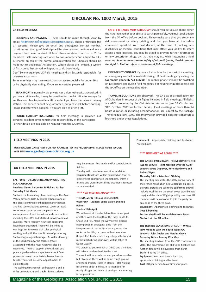
edges due to faulting, and poikilotopic cement (i.e. with
calcite crystals enclosing ooliths),
In addition, we were shown a block from a hardground near
the top of the face, with Trypanites worm boring. Peter
explained that this could be shown to be boring, not
burrowing, as a thin section shown in the hand-out and taken
from a similar piece showed the Trypanites cutting through
the ooliths. This
hardground was also
bored and encrusted by
oysters. Peter also
pointed out darker beds
situated above the
hardground at the top
of the face, where there
was cross-bedding,
gypsum filling of joints,
and iron staining. The
gypsum and iron
staining were
attributable to the
breakdown of pyrite in
the overlying Rutland
Formation.
We walked up a ramp
to our lunch spot, and
after lunch went down
into a hollow in a
heavily faulted area of
the quarry. In general,
workings in the quarry are divided between the lower quarry
(Lincolnshire Limestone) and the upper quarry (Rutland
Formation). However, in the faulted area it is possible to see
the whole succession,
though some layers,
notably the
Cornbrash, are
repeated as a result of
the faulting.
In the hollow,
mudstones from a
downthrown portion
of Rutland Formation
had been removed to
expose a fault plane of
L i n c o l n s h i r e
Limestone. The fault
had a maximum throw
of about 8m, but
tapered away to
nothing. Peter said
that the faulting could
be due to "valley
bulging" in the
underlying Lias. This
had given rise to
engineering problems
in the Welland Valley
in connection with the construction of Rutland Water.
However, a structural geologist he had spoken to had
expressed the view that the plane was too smooth, and the
fault too deep, for valley bulge. This suggested that tectonic
movements were a more likely explanation.
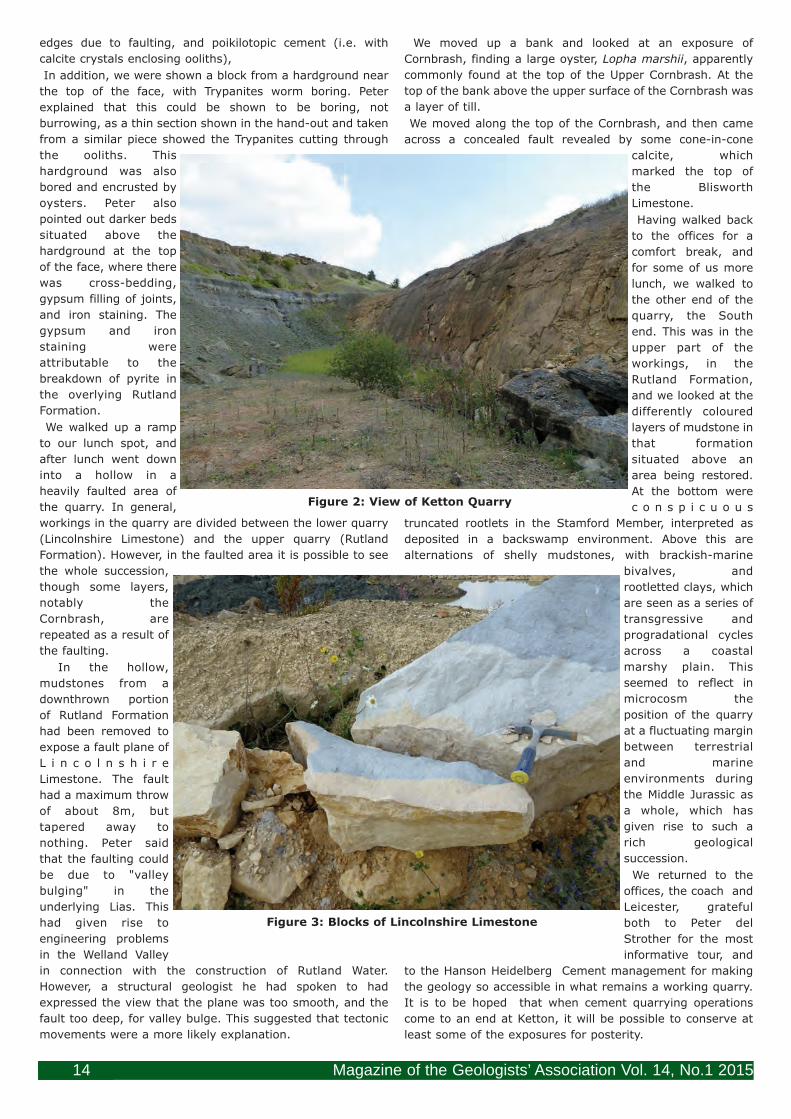
We moved up a bank and looked at an exposure of
Cornbrash, finding a large oyster, Lopha marshii, apparently
commonly found at the top of the Upper Cornbrash. At the
top of the bank above the upper surface of the Cornbrash was
a layer of till.
We moved along the top of the Cornbrash, and then came
across a concealed fault revealed by some cone-in-cone
calcite, which
marked the top of
the Blisworth
Limestone.
Having walked back
to the offices for a
comfort break, and
for some of us more
lunch, we walked to
the other end of the
quarry, the South
end. This was in the
upper part of the
workings, in the
Rutland Formation,
and we looked at the
differently coloured
layers of mudstone in
that formation
situated above an
area being restored.
At the bottom were
c o n s p i c u o u s
truncated rootlets in the Stamford Member, interpreted as
deposited in a backswamp environment. Above this are
alternations of shelly mudstones, with brackish-marine
bivalves, and
rootletted clays, which
are seen as a series of
transgressive and
progradational cycles
across a coastal
marshy plain. This
seemed to reflect in
microcosm the
position of the quarry
at a fluctuating margin
between terrestrial
and marine
environments during
the Middle Jurassic as
a whole, which has
given rise to such a
rich geological
succession.
We returned to the
offices, the coach and
Leicester, grateful
both to Peter del
Strother for the most
informative tour, and
to the Hanson Heidelberg Cement management for making
the geology so accessible in what remains a working quarry.
It is to be hoped that when cement quarrying operations
come to an end at Ketton, it will be possible to conserve at
least some of the exposures for posterity.
Figure 3: Blocks of Lincolnshire Limestone
Figure 2: View of Ketton Quarry
20084 GAMag March 2015 TOP COPY 26022015.qxp_mag41.qxd 05/03/2015 16:16 Page 14
GA FIELD MEETINGS
BOOKINGS AND PAYMENT: These should be made through Sarah byemail: [email protected], phone or through theGA website. Please give an email and emergency contact number.Locations and timings of field trips will be given nearer the time and oncepayment has been received. Unless otherwise stated the cost is £5 formembers. Field meetings are open to non-members but subject to a £5surcharge on top of the normal administration fee. Cheques should bemade out to Geologists’ Association. Where places are limited, a systemof first come, first served will operate so do book early. Geoff Swann organises UK Field meetings and Ian Sutton is responsible foroverseas excursions. Some meetings may have restrictions on age (especially for under 16s) or be physically demanding. If you are uncertain, please ask.
TRANSPORT is normally via private car unless otherwise advertised. Ifyou are a rail traveller, it may be possible for the GA office to arrange foranother member to provide a lift or collect you from the nearest railwaystation. This service cannot be guaranteed, but please ask before booking.Please indicate when booking, if you are able to offer a lift.
PUBLIC LIABILITY INSURANCE for field meetings is provided butpersonal accident cover remains the responsibility of the participant. Further details are available on request from the GA office.
SAFETY IS TAKEN VERY SERIOUSLY should you be unsure about eitherthe risks involved or your ability to participate safely, you must seek advicefrom the GA office before booking. Please make sure that you study anyrisk assessment or safety briefing and that you have all the safetyequipment specified. You must declare, at the time of booking, anydisabilities or medical conditions that may affect your ability to safelyattend a field meeting. You may be asked to provide further informationon any prescription drugs etc that you may use whilst attending a fieldmeeting. In order to ensure the safety of all participants, the GA reservesthe right to limit or refuse attendance at field meetings.
EMERGENCY CONTACT if you are lost or late for the start of a meeting,an emergency contact is available during UK field meetings by calling theGA mobile phone 07724 133290. The mobile phone will only be switchedon just before and during field meetings. For routine enquiries please callthe GA office on the usual number.
TRAVEL REGULATIONS are observed. The GA acts as a retail agent forATOL holders in respect of air flights included in field meetings. All flightsare ATOL protected by the Civil Aviation Authority (see GA Circular No.942, October 2000 for further details). Field meetings of more than 24hours duration or including accommodation are subject to the PackageTravel Regulations 1992. The information provided does not constitute abrochure under these Regulations.
CIRCULAR No. 1002 March, 2015
SALTFORD – DISCOVERING AND PROMOTING LOCAL GEOLOGYLeaders: Simon Carpenter & Richard Ashley Saturday 21st March Saltford is a fascinating place, nestling in the Avon Valley between Bath & Bristol. It boasts one of the oldest continually inhabited manor houses and has some fabulous geology. Lower Jurassic rocks are exposed across the parish as a consequence of past industries and construction including the GWR and Midland railways and old quarries. More recently, new rock exposures have been excavated. These will be linked to existing sites to create a circular geological walking trail with the specific aim of promoting Saltford’s geological heritage. As well as looking at the solid geology, the terrace gravels associated with the River Avon will also be examined. The final stop on the walk will be a private garden where a spectacular rock face preserves many characteristic Lower Jurassic fossils. There will be some opportunities to collect fossils. The walking distance will be between 2 and 3 miles on footpaths and tracks. Some surfaces
may be uneven. Pub lunch and/or sandwiches in Saltford. The day will come to a close at around 4pm.Equipment: Saltford will be explored on foot, so please wear appropriate shoes/boots, warm clothing and waterproofs if the weather is forecast to be unsettled.
**** NEW MEETING ADDED ****
THE MALVERN HILLS, A GEOLOGICAL VIEWPOINT Leaders: Eddie Bailey and Rob Palmer Sunday 26th April We will meet at Herefordshire Beacon car park and then walk the length of the ridge south to Chase End Hill. Along the way we will discuss every period in geological time from the Neoproterozoic to the Quaternary, using the rocks on the hills, or those within clear view (hopefully!) to illustrate the geological history. A picnic lunch (bring your own) will be taken at Gullet Quarry. We expect to get to finish at 16:00 and a minibus will take attendees back to the start. The walk will be as relaxed and paced as possible but obviously there will be some rough ground and steep muddy tracks in places. Total walking distance is about 6 miles. It is intended for nearly all ages and levels of geology. Hammering is not permitted.
Equipment: Appropriate clothing and footwear. Packed lunch.
**** NEW MEETING ADDED ****
THE ANGLO-PARIS BASIN - FROM DOVER TO THE ISLE OF WIGHT – joint meeting with the AGBP Leaders: Anne Duperret, Rory Mortimore and Robert Wyns Thursday 14th - Saturday 16th May This meeting celebrates the 50th anniversary of the French Association des Geologues du Bassin de Paris. Details are still to be confirmed but willinclude localities on the south coast (possibly two days) and the Isle of Wight (possibly one day). GA members will be welcome to join the party on any or all of the three days. Equipment: Appropriate clothing and footwear. Cost & booking:Further details will be available from Sarah Stafford at the GA office.
THE OLD RED SANDSTONE OF SOUTH WALES - joint meeting with the South Wales GALeaders: John Davies and Geraint Owen Saturday 16th – Sunday 17th May This meeting leads on from the ORS conference in 2014. The programme has still to be finalised and further details will be available from Sarah Stafford at the GA office.Equipment: You must have a hard hat, appropriate clothing and footwear. Cost £10 per person to confirm your place.
FIELD MEETINGS IN 2015
FOR FINALISED DATES AND FOR ANY CHANGES TO THE PROGRAMME PLEASE REFER TO OUR WEB SITE www.geologistsassociation.org.uk
UK FIELD MEETINGS IN 2015
Magazine of the Geologists’ Association Vol. 14, No.1 2015 15
20084 GAMag March 2015 TOP COPY 26022015.qxp_mag41.qxd 05/03/2015 16:16 Page 15

WILLIAM SMITH AND BATHLeader: Hugh Torrens Saturday 6th June This meeting is part of countrywide celebrations of the bicentenary of William Smith's map of 1815. This was an achievement of which Henry Peter Brougham (1778–1868), Lord Chancellor and essayist could write, before Smith's death, how this “delineation of the strata of a whole country”, was “certainly the most extraordinarywork that any single, and private, individual [had]ever accomplished”. The trip will focus on the most significant places where Smith was involved. These will include a walking tour, in and around Bath, to show the party at least 29 Pulteney Street, Smith and Cruse's office in Trim Street, The Bath Royal Literary and Scientific Institution in Queen Square. We will also visit several sites outside Bath to include his home at Cottage Crescent, the site of his attempt to find coal at Batheaston and the complex story at Tucking Mill House.
OXFORDSHIRE GEOLOGICAL HIGHLIGHTSLeader: Mike Howgate Saturday 20th June We will meet in the village of Stonesfield where we will see the small Stonesfield slate display inside the church. We will then have the opportunity to descend one of the Stonesfield Slate mines. If you wish to descend remember that it is 50 feet deep and going down is easy compared to climbing back up. After that we will have time to collect from one of the spoil heaps in the village. In the afternoon we will travel to the village of Churchill, birthplace of William Smith the father of stratigraphy, where we can have lunch at the Chequers Inn which was run by Smith’s stepfather and where he probably drank many a pint. We will then see the site of the cottage where he was born, the memorial to him and the small display in the Heritage Centre.Our final stop, time permitting, will be to see the atmospheric Rollright Stones and Whispering Knights. Equipment: You must have a hard hat, appropriate clothing and footwear. Please bring a torch. Cost £10. Due to the visit to a 50 foot deep mine numbers will be limited to 15 FIT individuals.
WEALDEN EXCURSION - joint meeting with the Hastings & District Geological SocietyLeaders: Ken Brooks, Peter Austen and Ed JarzembowskiSunday 26th July Following the last two years’ field visits covering the coastal sections between Cliff End and Fairlight Glen, we will be looking to complete the final section of this classic 5 mile lower Wealden coastline from Fairlight Glen to Rock-a-Nore. Once again the exact details of the field trip will not be known until nearer the time as it will depend on access conditions at either end of the section.Equipment: You must bring a hard hat and suitable footwear. Packed lunch. We will be
walking along the beach over shingle and some rocks which may be slippery. Care should also be taken to keep away from the base of the cliffs in case of rock-falls, particularly after wet weather.
GEOLOGICAL HIGHLIGHTS OF MARTLEY,
WORCESTERSHIRE – joint meeting with the
Teme Valley Geological Society
Leaders: John Nicklin and others
Saturday 8th August
The Martley area is geologically varied and
represents in microcosm a large part of the
geological variety of the British Isles. We will be
following one or more of the TVGS’ geological
trails though details are still to be decided. More
information on the area can be found on the
TVGS website http://www.geo-village.eu/
Equipment: You must bring a hard hat and
suitable clothing and footwear. Bring a packed
lunch.
THE GEOLOGY OF RECULVER COUNTRY PARK
Leader: Geoff Downer
Sunday 23rd August
We will study the early Palaeogene sediments of
this, the type locality for the Thanet Sands
Formation and the overlying beds along the
stretch of coast in North Kent between
Bishopstone and Reculver. We shall also review
the various measures taken to protect sections of
this coastline and the reasons behind these
schemes. In the afternoon we shall examine two
ancient scheduled monuments, the wall of the
Roman shore fort of Regulbium and St Mary’s
Church, Reculver, to see the range of building
stone used and to consider the provenance of the
material. Most of the morning walk is along a
shingle beach. We may go briefly onto the
foreshore which is usually firm sandy silt with
large sandstone blocks. Walking distance is about
5km. The morning will be a slow pace and the
return overland walk is at each individual’s own
pace. Approx finish at 4:30pm.
Equipment: Suitable clothing and footwear -
walking boots/stick recommended. Hand lens,
note book, camera.
There is a pub at Reculver and a cafe that is
usually open during the summer months.
Alternatively bring a packed lunch.
Cost & booking: Instead of a conventional
handout each participant may purchase copies of
the two Reculver Country Park guides for £2.50
(retail price is £9.00 for the two) to cover printing
costs (payable on the day).
DORSET COAST WEEKEND
Leader: Prof John C.W. Cope (National Museum
of Wales)
September 12th - 13th (Date now confirmed)
Following the success of the previous three
meetings to the west Dorset coast we will be
based in Swanage and will be looking mainly at
the Upper Jurassic of the Isle of Purbeck. We will
finish at about 16:00 on Sunday.
Equipment: Participants should be equipped for
very rough beaches and should have stout
footwear with ankle support. Helmets and hi vis
jackets are essential. There may well be some
steep ascents (and descents) dependent on the
weather.
Cost & booking: Numbers will be limited to 25.
Register with Sarah Stafford at the GA office
sending an administration fee of £15 to confirm
your place.
THE LOWER THAMES GRAVELS
Leaders: David Bridgland and Peter Allen
Sunday 6th September (date now
confirmed)
This meeting leads on from the QRA conference
in 2014. We will visit classic sites in the Lower
Thames including Wansunt Pit (Dartford Heath),
Swanscombe Skull Site NNR, Purfleet (Greenlands
Quarry) and Lion Pit Tramway Cutting.
Transport will be by coach from a central London
(Embankment) pick up plus a local station pick up
and drop off. Car users should note that we'll
start and finish on different sides of the river.
Cost will be approximately £25 (transport
included) and attendees will be able to buy this
year's QRA field guide for ~£15.00.
THE BUILDING STONES OF ST ALBANS
Leader: Di Smith
16 August (date now confirmed)
This meeting has been carried over from 2014.
We will be looking at a variety of building stones
of various ages including those of the cathedral.
The walk will last approximately 2 ½ hours and
will not be strenuous. Afterwards it should be
possible to visit the Verulaneum museum with i ts collection of Roman and related artefacts.
**** NEW MEETING ADDED ****
DEVONSHIRE MARBLES WEEKEND
Leader: Prof Gordon Walkden (Univ of
Aberdeen)
Friday 2th – Sunday 27th September
This meeting celebrates the publication of Prof
Walkden’s new GA guide Devonshire marbles:
Their geology, history and uses (2 vols).
On Friday there will be the book launch at
Torquay Museum followed by an afternoon or
evening lecture: The amazing Devonshire
Marbles: eloquence in stony silence- the
surprising geology, history and uses of the
greatest British marbles.
On Saturday we will visit two great Devonshire
marble buildings to discover their architecture,
history and geology. In the morning we visit All
Saints Church (quintessential Devonshire Marble
church by the great William Butterfield) and in
the afternoon St John’s Church (the less well
known Devonshire marble beauty by George
Edmund Street). There will be a lunch stop at
Torquay Museum. On Sunday there is a field trip
Magazine of the Geologists’ Association Vol. 14, No.1 201516
20084 GAMag March 2015 TOP COPY 26022015.qxp_mag41.qxd 05/03/2015 16:16 Page 16
to see local marble-related geology. In the
morning, at Petit Tor, Babbacombe to see the
complex geology at the most famous of the
marble localities. In the afternoon, Hope’s Nose -
some of the showiestDevonian sediments and
fossils, upset by storms, sea level change and
volcanicity – and with a trace of gold. Picnic
lunch.
Neither locality is tide dependent but in the event
of bad weather we will have a reserve locality. All
localities will require car sharing.
Equipment: Participants should have stout
footwear with ankle support. Helmets and hi vis
jackets are essential.
Cost & booking: Numbers for the field meetings
will be limited to 30.
IN THE PIPELINE (Dates and details to be
THE BUILDING STONES WALK IN LONDON Leader: Ruth Siddall
Date to be confirmed
Another of Ruth’s popular walks on a summer
evening
THE GEOLOGY OF THE SEVERN VALLEY RAILWAY Leader: Peter Worsley
Sunday 12th July 2015 (date now confirmed) For
some 27 km, today’s Severn Valley Railway
(SVR), follows a particularly scenic route from
Kidderminster (Worcestershire) to Bridgnorth
(Shropshire). This year it celebrates the Golden
Jubilee of its foundation as a heritage railway. For
most of the route the line runs close to the river
giving splendid landscape views which cannot be
obtained from any road. The three main
elements of the geology to be examined are:-
Carboniferous Coal Measures, Permo-Triassic
sandstones and Quaternary fluvial sediments and
landforms.
The visit will commence with the 10.30 departure
from Kidderminster arriving at Bridgnorth at
11.38. A walking tour of the town centre geology
will follow with time for a quick lunch prior to
taking the 13.40 train to Hampton Loade (20
mins). Hopefully the ferry across the river will be
operative and it will be possible to follow the east
bank footpath southwards to the site of the
former Alveley Colliery. After examining the
Country Park Visitor Centre on the reclaimed
colliery tip, the path then crosses to the west
bank and leads down to Highley station. There
should be time to visit the adjacent ‘Engine
House’ Museum (admission included in the fare)
before catching the 16.42 back to Kidderminster,
arriving at 17.20. Both Bridgnorth and
Kidderminster stations have real ale pubs on the
platform.
Participants will need to walk 6-7 km on paved
and unpaved public footpaths and be able to
board and alight a small ferry. The SVR
Kidderminster station is adjacent to the
eponymous National Rail station. Be warned! –
besides being a geologist, the leader is a railway enthusiast.Equipment: Appropriate clothing and footwear. Cost & booking: Total cost will depend on numbers but should be c £25 to include a pre booked group discount ticket. Register with Sarah to confirm your place.
BUCKS GEOLOGY
Leader: Jill Eyers
Date to be confirmed
We are still hoping that this meeting will take
place subject to access problems being solved.
We will visit several quarries, one of which has
been restored in part by a grant from the Curry
Fund.
Packed or pub lunch, car sharing may be
necessary.
Equipment: Hard hat and hi-vis jacket.
Appropriate clothing and footwear. Attendees
should be capable of dealing with the conditions
in working quarries.
PORTUGAL
Leaders: Diamantino Insua Pereira,
Universidade do Minho; Pedro Cunha,
Universidade do Coimbra;
Antonia Martins, Universidade do Évora;
Prof David Bridgland, University of Durham
Monday 11th – Tuesday 19th May
8 days in Portugal starting in Porto and working
south to Lisbon with overnight stops in Porto,
Macedo de Cavaleiros, Foz Coa, Coimbra, Ródão,
Abrantes, Almeirim and Lisbon. The trips will
include the Knights Land Geopark (Day 1), the
upper valley of the Douro River and the UNESCO
Prehistoric Rock-Art Site in the Côa Valley, a
World Heritage Site (Day 2), Alto Douro wine
region
World Heritage Site (Day 3), cruise on the Tejo
River into the Portas do Ródão gorge and visit to
the “conhal” do Arneiro open-air Roman gold
mine and Palaeolithic sites (Days 5),
archaeological sites in the middle reaches of the
Tejo River including the Archaeological museum
of Vila Nova da Barquinha (Day 6) and Quaternary
sites between Almeirim and Lisbon on Day 7. Level of fitness required: some sites will involve
fairly lengthy walks in quarries and along tracks.
Travel will be by coach within Portugal but
participants will need to make their own travel
arrangements to and from Portugal. There will be
an opportunity to extend your trip at either end
to enjoy the cultural sites of Porto &/or Lisbon. Cost & booking: Register with the GA office know
if you are interested in this trip and full details of
itinerary will be sent to you. Costs will be
circulated as soon as they are confirmed. They
will include hotels B&B, coach travel and entrance fees where applicable.
GREEK ISLAND VOLCANOES
Leader: Paul Olver
Monday 14th – Sunday 27th September
This trip is now FULL, however, if you would like
to be put on the waiting list in case of cancellation
please email [email protected] Tel: 01432
761 693.
Amateur Geological Society
Contact Julia Daniels 020 8346 1056
Email:[email protected]
Field trips: [email protected]
www.amgeolsoc.webspace.virginmedia.com/Liv e_Site/Home.html
Bath Geological Society
March 21 Field meeting: Jurassic rocks of Oxfordshire
– Eliz abeth Devon
www.bathgeolsoc.org.uk
Belfast Geologists’ Society
March 16 Harold Wilson Memorial Lecture. An
overview of the Donegal Granites.
April 20 AGM.
Contact [email protected]
www.belfastgeologists.org.uk
Black Country Geological Society
March 16 AGM followed by Minerals and Gems of the
Cairngorms – Roy Starkey
Contact: Linda Tonkin: [email protected]
www.bcgs.info
Brighton & Hove Geological Society
March 4 Solving Darwin's dilemma: the barnacle fossil
record – Prof Andy Gale
March 18 AGM and Members' Evening
April 1 Foraminiferal facts: from Cretaceous
palaeoclimates to Caribbean tephrochronology - Dr Jodie FisherContact John Cooper 01273 292780 Email: [email protected] www.bhgs.org Bristol Naturalists’ Society Contact 01373 474086 Email: [email protected] Cambridgeshire Geology Club (LG) Contact Ken Rolfe 01480 496973, mob: 07777 678685 www.cambridgeshiregeologyclub.org.uk Carn Brea Mining Society Contact Lincoln James 01326 311420 www.carnbreaminingsociety.co.uk
Magazine of the Geologists’ Association Vol. 14, No.1 2015 17
GEOLOGISTS’ ASSOCIATION LOCAL GROUPS (LG) & AFFILIATED SOCIETIES
OVERSEAS FIELD MEETINGS IN 2015
20084 GAMag March 2015 TOP COPY 26022015.qxp_mag41.qxd 05/03/2015 16:16 Page 17
arranged)...........................
Cheltenham Mineral and Geological Society
Lectures contact Ann Kent 01452 610375
Field trips contact Kath Vickers 01453 827007
http://cmgs.yolasite.com
Cumberland Geological Society
For details on the activities of the Cumberland
Geological Society
www.cumberland-geol-soc.org.uk
Cymdeithas Daeaereg Gogledd Cymru: North
Wales Geology Association (LG)
Contact Jonathan Wilkins 01492 583052 Email:
www.ampyx.org.uk/cdgc
Cymdeithas Y Daearegwyr Grwp De Cymru: South
Wales Group Geologists’ Association (LG)
March 21 (Cardiff) AGM and Bob Owens (NMW) –
The DA Bassett memorial Lecture: From Welsh
Geosyncline to Welsh Basin
Contact Lynda Garfield: [email protected] www.swga.org.uk
The Devonshire Association (Geology Section)
April 11 President’s Symposium Devon’s potential
energy budget 2050.
May 15-17 Field weekend: Bath/Somerset to visit
some of the sites investigated by William Smith –
Prof Hugh Torrens
June 5-7 Associations Annual Meeting
Contact Jenny Bennett 01647 24033 Email:
www.devonassoc.org.uk
The Dinosaur Society
Contact Prof Richard Moody:
www.dinosaursociety.com.
Dorset Group of the Geologists’ Association (LG)
Contact Doreen Smith 01300 320811 Email:
www.dorsetgeologistsassociation.com
Dorset Natural History & Archaeological Society
Contact Jenny Cripps:
Earth Science Teachers Association Membership
Mike Tuke 014804 57068
Details www.esta-uk.net
East Herts Geology Club
Contact Diana Perkins 01920 463755
Visitors most welcome - £2; Email:
[email protected] www.ehgc.org.uk
East Midlands Geological Society
March 21 AGM followed by The North Anatolian
Fault – Ekbal Hussain
April 18 Confessions of a Flint Napper – Phil
Harding www.emgs.org.uk
Edinburgh Geological Society
March 11 New light on the Caledonides of the
Shetland Islands – Rob Strachan
March 25 A geological future in Scotland ? – Stuart
Monro Email: [email protected]
www.edinburghgeolsoc.org
Essex Rock and Mineral Society (LG)
March 10 The Neanderthals – Prof Chris Stringer Contact Ros Smith 01245 441201 Email:
www.erms.org
Farnham Geological Society (LG)
Field Trip Contact Dr Graham Williams 01483
573802; Contact Judith Wilson Email:
www.farnhamgeosoc.org.uk
Friends of the Sedgwick Museum, Cambridge Contact Dr Peter Friend 01223 333400
www.sedgwickmuseum.org/activities/friends.html Geological Society of Glasgow
March 12 Are the Early Palaeogene lava fields of
NW Scotland monotonous piles of old, cod and
very boring basalt? – Ian Williamson.
April 9 Atacama Desert: the chicken or the egg
scenario – Dr Laura Evenstar.
Contact Dr Iain Allison Email:
www.geologyglasgow.org.uk
Geological Society of Norfolk
Contact Martin Warren Email:
www.norfolkgeology.co.uk
Harrow & Hillingdon Geological Society (LG)
March 11 Using past warm climates to inform us
about our future world - Dr Chris Brierley (UCL)
April 8 A journey through the centre of a mountain
- Bernard J Skillerne de Bristowe
May 13 AGM
June 10 That sinking feeling: geology, people and
subsidence - Dr Philip Collins
Contact Jean Sippy 020 8422 1859; Field trip
information Allan Wheeler 01344 455451
www.hhgs.org.uk
Hastings and District Geological Society
March 15 Ice Age Sussex - Colin Whiteman
April 19 Mineralogy at the Natural History
Museum – Prof Andy Fleet
May 17 How Britain Became an Island – Dr
Sanjeev Gupta Contact Ken Brooks Email:
[email protected] http://
hastingsgeology.btck.co.uk
Hertfordshire Geological Society (LG)
Contact Lesley Exton Email:
www.hertsgeolsoc.ology.org.uk
Horsham Geological Field Club March 11 Modelling Ancient tides – Dr Peter
Allison
April 8 Underlands – a journey through Britain’s
lost landscape – Dr Ted Nield, Editor of
GeoScientist
May 13 AGM
Contact Mrs Gill Woodhatch 01403 250371
www.hgfc.uwclub.net/Index.html
Huddersfield Geology Group
Contact Julie Earnshaw Email:
Web: www.huddersfieldgeology.org.uk
Hull Geological Society
Contact Mike Horne 01482 346784 Email:
[email protected] www.hullgeolsoc.org.uk The
Jurassic Coast
May 1-3 Lyme Regis Fossil Festival
Mapping the Earth
details:www.fossilfestival.co.uk
www.jurassiccoast.com
Kent Geologists’ Group of the Geologists’
Association (LG)
Indoor Secretary Mrs Ann Barrett 01233 623126
Email: [email protected]
www.kgg.org.uk
The Kirkaldy Society (Alumni of Queen Mary
College) (LG)
Contact Mike Howgate 020 8882 2606 Email:
[email protected] or [email protected] Lancashire Group of the Geologists’ Association
(LG)
March 27 The Manchester Building Stones – Peter
del Strother & Jennifer Rhodes
Secretary Jennifer Rhodes 01204 811203 Email:
www.lancashire-geologists.co.uk
Leeds Geological Association
March 19 An overview of the York Potash Project - Tristan Pottas, York Potash LtdApril 23 35 Years on the road with Shell in Russia,
the Far East and India – Nick Shaw
April 25 Yorkshire’s Rocks and Minerals Day at the
National Coal Mining Museum, Wakefield. Launch
of Yorkshire Geology Month.
Visitors welcome. Details Judith Dawson 0113
2781060 www.leedsga.org.uk
Leicester Literary & Philosophical Society
(Geology)
March 7 Annual Seminar: Seven Steps to
becoming Human
March 11 Stonehenge: recent unique discoveries
in the Chalk – Rory Mortimore.
Contact Joanne Norris 0116 283 3127 Email:
[email protected] www.charnia.org.uk
Liverpool Geological Society
Contact Joe Crossley 0151 426 1324 Email:
Magazine of the Geologists’ Association Vol. 14, No.1 201518
20084 GAMag March 2015 TOP COPY 26022015.qxp_mag41.qxd 05/03/2015 16:16 Page 18

www.liverpoolgeologicalsociety.org.uk Manchester Geological Association
Contact Sue Plumb 0161 427 5835 Email:
www.mangeolassoc.org.uk
Mid Wales Geology Club
Contact Bill Bagley 01686 412679
www.midwalesgeology.org.uk
Mid Week Geology Club in Yorkshire
Contact [email protected]
http://mwggyorkshire.webspace.virginmedia.com Mole Valley Geological Society (LG)
March 12 Lucky Planet – David Waltham
April 25 Field trip: Eastbourne – Rory Mortimore
May 14 Earth’s Climate evolution: from
Greenhouse to Icehouse – Dr Colin Summerhayes June 11 Summer Soiree: Members evening of
mini-lectures with Pimms and chilled wine
Secretary [email protected]
www.mvgs.org.uk
Newbury Geological Study Group
Field Meetings season runs from October to July.
Normally meets on the third Sunday of the month. Details Mike & Helen Weideli 01635 42190 www.ngsg.org.uk
Norfolk Mineral & Lapidary Society
Meetings at St Georges Church Hall, Churchfield
Green, Norwich. 19.30hrs every first Tuesday of
the Month except August
Contact Colin Lansdell: [email protected]
http://norfolkminandlapsoc.homestead.com/
North Eastern Geological Society
Details Christine Burridge Email:
www.northeast-geolsoc.50megs.com
North Staffordshire Group of the Geologists'
Association (LG)
March 12 AGM & Chair’s Address
Details Eileen Fraser 01260 271505
www.esci.keele.ac.uk/nsgga/
Open University Geological Society
Events listed on http://ougs.org, or contact
The membership secretary is Phyllis Turkington
email: [email protected]; tel: 0289 081 7470 Oxford Geology Group (LG)
Programme Secretary 07901 672713
www.oxgg.org.uk
Ravensbourne Geological Society (LG)
March 10 The Geology Collection at Horniman
Museum – Paolo Viscardi
Secretary Carole McCarthy 020 8127 6104 Email:
[email protected] or Vernon Marks 020
8460 2354. www.ravensbourne-geology.org.uk
Reading Geological Society (LG)
March 2 Presidential Address: Geology of Old
Father Thames – Prof Peter Worsley
March 15 Field meeting: Big Pit, Cardiff – Tom
Sharpe April 13 Geological evolution of the North
American Cordillera – Prof Douglas Robinson
April 19 Field meeting: Martley Valley,
Worcestershire, East Malvern Fault, Silurian to
Triassic – John Nicklin
May 11 The London Underground Extension –
Jonathan Gammon
May 15-18 Field weekend: Derbyshire, Castleton,
Wirksworth, Ashover, Carboniferous & Devonian
– John Hunter
June 1 Evening geological ramble – local leader
General Secretary Hilary Jensen 0118 984 1600
Email: [email protected]; Field trips
David Ward 01344 483563
www.readinggeology.org.uk
Royal Geological Society of Cornwall
Contact 01209 860410 Email:
[email protected] www.rgsc.org.uk The
Russell Society
Contact Frank Ince Email:
[email protected] www.russellsoc.org Shropshire Geological Society
www.shropshiregeology.org.uk
Sidcup Lapidary and Mineral Society
Contact Graham Bell 020 8300 4770
Meets every Monday evening at Sidcup Arts
Centre. Contact Nicola Claxton 01322 227 057
Email: [email protected]
www.sidcuplapminsoc.org.uk
Southampton Mineral and Fossil Society Contact Gary Morse 01489 787300 Email:
www.sotonminfoss.org.uk
Stamford and District Geological Society Contact [email protected] www.stamfordgeolsoc.org.uk
Teme Valley Geological Society
John Nicklin: [email protected]
www.geo-village.eu
Ussher Society
Contact Elaine Burt: [email protected] www.ussher.org.uk
Warwickshire Geological Conservation Group March 18 William Smith – Tom Sharpe
April 15 Minerals, Magmas and Man – Paul Olver Contact Frank Wells 01926 512696 Email:
[email protected] www.wgcg.co.uk West of England Group of the Geologists’
Association (LG)
January 13 Science without borders: Unravelling
the mysteries of Mt. Paektu volcano, North Korea -Dr James Hammond
February 10 Research Students: Various
Topics – Three Research Students Bristol University
March 10 Britain from the air: Aerial mapping in
the south west – Dr Andrew Howard
Secretary Bobby Oliver: [email protected] www.wega.org.uk
West Sussex Geological Society (LG)
March 20 Barremian Wessex Formation of the
Isle
of Wight – Dr J. Matter
April 17 Lusi Mud Volcano Disaster in Indonesia –
David Shilston
Contact Betty Steel 01903 209140 Email:
[email protected]. www.wsgs.org.uk Westmorland Geological Society
Contact Brian Kettle: [email protected]
www.westmorlandgeolsoc.co.uk
Winchester Geology Society
Contact: [email protected]. https://sites.google.com/site/
winchestergeologys ociety/
The Woolhope, Hereford
March 20 EARS: The East African Rift System in
Kenya – Dr Bill Fitches
April 26 Huntsham Hill geology and landscape –
Moira Jenkins. Contact Sue Hay 01432 357138
Email: svh.gabbros@btinternet .com
www.woolhopeclub.org.uk
Yorkshire Geological Society
March 24 Tetrapod world - the multidisciplinary
Tweed project – John Knight, David Milward and
Claire Dashwood.
April 25 Yorkshire Rock and Fossil Day. Afternoon
lecture Geology and your Health.
May- June
Yorkshire Geology Month.
Contact Trevor Morse 01833 638893
www.yorksgeolsoc.org.uk
Oxford Geology Group: Oxford Colloquium March 7 Details: www.oxgg.org.uk
Lyme Regis Fossil Festival: Mapping the Earth
May 1-3 Details: www.fossilfestival.co.uk
Launch of Yorkshire Geology Month: Yorkshire’s Rocks and Minerals Day
National Coal Mining Museum, Wakefield April 25 Details www.leedsga.org.uk
www.yorksgeolsoc.org.uk
The William Smith map bicentenary
Look out for events near you. Details from
the Geological Society.
www.geolsoc.org.uk/Events/William-Smith-
Bicentenary
Magazine of the Geologists’ Association Vol. 14, No.1 2015 19
SPECIAL EVENTS
20084 GAMag March 2015 TOP COPY 26022015.qxp_mag41.qxd 05/03/2015 16:16 Page 19
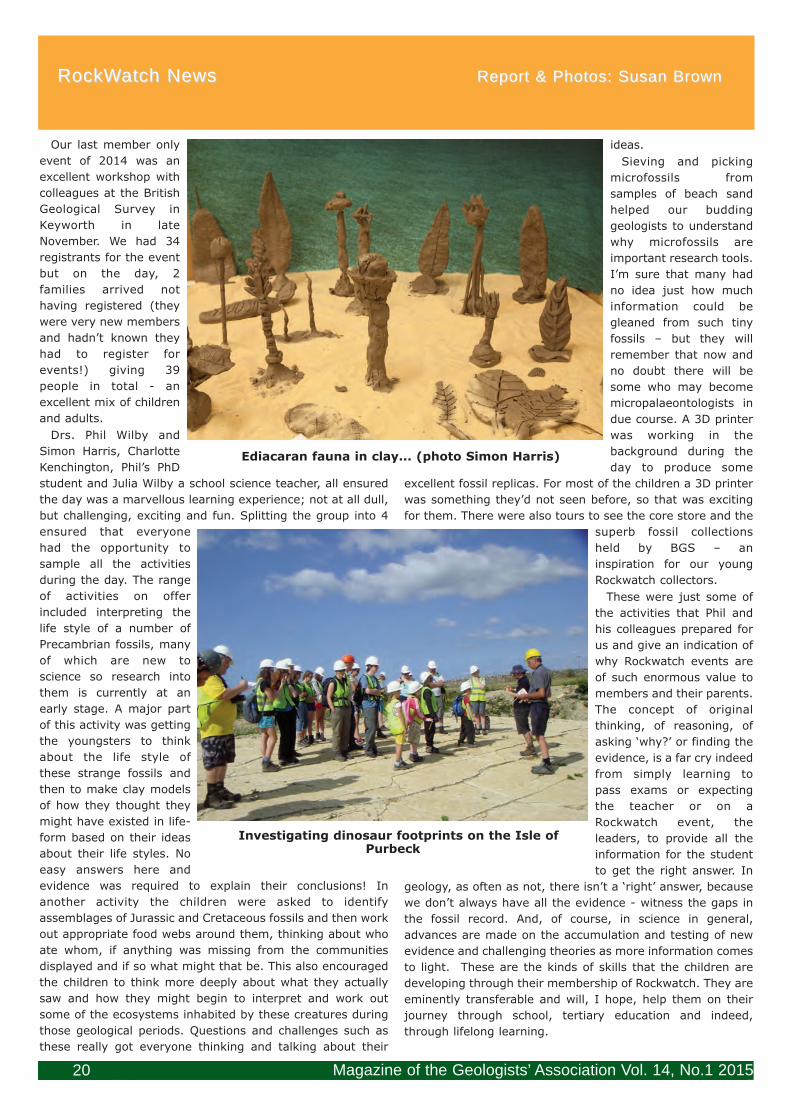
Magazine of the Geologists’ Association Vol. 14, No.1 201520
RockWatch NewsRockWatch News Report & Photos: Susan BrownReport & Photos: Susan Brown
Our last member only
event of 2014 was an
excellent workshop with
colleagues at the British
Geological Survey in
Keyworth in late
November. We had 34
registrants for the event
but on the day, 2
families arrived not
having registered (they
were very new members
and hadn’t known they
had to register for
events!) giving 39
people in total - an
excellent mix of children
and adults.
Drs. Phil Wilby and
Simon Harris, Charlotte
Kenchington, Phil’s PhD
student and Julia Wilby a school science teacher, all ensured
the day was a marvellous learning experience; not at all dull,
but challenging, exciting and fun. Splitting the group into 4
ensured that everyone
had the opportunity to
sample all the activities
during the day. The range
of activities on offer
included interpreting the
life style of a number of
Precambrian fossils, many
of which are new to
science so research into
them is currently at an
early stage. A major part
of this activity was getting
the youngsters to think
about the life style of
these strange fossils and
then to make clay models
of how they thought they
might have existed in life-
form based on their ideas
about their life styles. No
easy answers here and
evidence was required to explain their conclusions! In
another activity the children were asked to identify
assemblages of Jurassic and Cretaceous fossils and then work
out appropriate food webs around them, thinking about who
ate whom, if anything was missing from the communities
displayed and if so what might that be. This also encouraged
the children to think more deeply about what they actually
saw and how they might begin to interpret and work out
some of the ecosystems inhabited by these creatures during
those geological periods. Questions and challenges such as
these really got everyone thinking and talking about their
ideas.
Sieving and picking
microfossils from
samples of beach sand
helped our budding
geologists to understand
why microfossils are
important research tools.
I’m sure that many had
no idea just how much
information could be
gleaned from such tiny
fossils – but they will
remember that now and
no doubt there will be
some who may become
micropalaeontologists in
due course. A 3D printer
was working in the
background during the
day to produce some
excellent fossil replicas. For most of the children a 3D printer
was something they’d not seen before, so that was exciting
for them. There were also tours to see the core store and the
superb fossil collections
held by BGS – an
inspiration for our young
Rockwatch collectors.
These were just some of
the activities that Phil and
his colleagues prepared for
us and give an indication of
why Rockwatch events are
of such enormous value to
members and their parents.
The concept of original
thinking, of reasoning, of
asking ‘why?’ or finding the
evidence, is a far cry indeed
from simply learning to
pass exams or expecting
the teacher or on a
Rockwatch event, the
leaders, to provide all the
information for the student
to get the right answer. In
geology, as often as not, there isn’t a ‘right’ answer, because
we don’t always have all the evidence - witness the gaps in
the fossil record. And, of course, in science in general,
advances are made on the accumulation and testing of new
evidence and challenging theories as more information comes
to light. These are the kinds of skills that the children are
developing through their membership of Rockwatch. They are
eminently transferable and will, I hope, help them on their
journey through school, tertiary education and indeed,
through lifelong learning.
Ediacaran fauna in clay... (photo Simon Harris)
Investigating dinosaur footprints on the Isle ofPurbeck
20084 GAMag March 2015 TOP COPY 26022015.qxp_mag41.qxd 05/03/2015 16:16 Page 20

Curry Fund ReportCurry Fund Report Susan BrownSusan Brown
We received eight new applications at our December
meeting of which five received funding, two were refused
and a decision on one awaited further information.
An application from the Dorset geologists’ Association
Group (DGAG) requested £1,350 towards the cost of its
activities to celebrate the Bicentenary in 2015 of William
Smith’s first Geological Map of England and Wales. This will
cover talks, a booklet and a meeting. £1,000 is requested as
a loan for a book and £350 as a grant. It is hoped that papers
from the meeting will be published in the PGAS in due
course. A loan of £1000 repayable within two years and a
grant of £350 was awarded. Gloucestershire Wildlife Trust
requested £1,540 towards the cost of professional input from
a geologist from the Gloucestershire Geology Trust. This
input will include geological conservation work and delivering
public engagement events as part of your “All Paths lead to
the Hill” project. A grant of £1,540 was offered with one of
the attached conditions being a short illustrated article to be
written for the GA Magazine. £500 was awarded to the Lyme
Regis Development Trust towards the cost of the Fossil
Festival to be held during the first May Bank Holiday this
year. The theme this year will celebrate the Willima Smith
Map Bicentenary. Foyle College in Londonderry requested
£500 for fossil moulds and associated resources to enable it
to offer replica fossil making activities to its students. A grant
of £500 was agreed.
Of the applications refused support, one was from Dave
Wallis for £3,000 towards development of an ‘app’ and
website for ‘London Pavement Geology’. The committee
expressed an interest in the project but felt that further
detailed development was required before it could commit.
In particular sustainability and alterability information about
the proposals were required along with more detailed
geology of the sites. The British Geological Survey requested
£700 towards the reprinting costs of its poster ‘Climate
through Time’ which had proved very successful. This was
refused as the committee felt that the costs could readily be
recovered by the charge of £1 per poster which was due to
be imposed on the reprinted copies. The application from
Alan Harrison for £400 to cover the cost of printing his ‘Field
Guide to the Geology and Quaternary History of Pendle Hill’
was deferred but after information from the author stating
that the guide is to be distributed free of charge through
local libraries, tourist offices and two local ‘geo-societies’ it
was agreed to offer a grant of £400.
Following our usual format, meetings this year will be on
the second Friday of March, June, September and December.
Applications must be in the GA office by the 20th of each
month preceding the meeting. The Guidelines for Applicants
and the application form are on the GA website and we look
forward to hearing from you.
Magazine of the Geologists’ Association Vol. 14, No.1 2015 21
Rockwatch members are extremely fortunate to have such
opportunities as these. It is thanks to people like Phil, Simon
and Charlotte in this instance, but over the years, thanks to
so many geological colleagues, who give up their time so
willingly to help these
young people. It is their
patience and guidance
that give Rockwatchers
the skills and confidence
to go out into the field, to
find their own rocks,
fossils and minerals, to
query their provenance,
life styles and mode of
formation. Increasing
levels of confidence and
the development of
thinking skills enable
these youngsters to
learn to question and to
put forward their own
answers to many of the
questions that will arise
based on the evidence
they accumulate and the
skills they develop over
time.
And so to another year of Rockwatch events and activities
for members and the general public. We already have a
number of public events scheduled including the Family Day
with BGS colleagues at the end of the Science Week. I will be
spending with them in Keyworth working with local schools;
the Lyme Regis Fossil Festival; primary school visits and
museum public family
activity days. Our annual
week’s residential course
on the World Heritage
Coast of Dorset & East
Devon is booked for the
end of July and is a firm
favourite for many
members. We continue
to get news from a
number of our former
members who seem to
go from strength to
strength as I report on
these pages when I have
news from them. I am
currently planning field
trips for the coming
season as well as more
public events and look
forward to seeing some
of you, GA members,
when we have trips to your part of the country, but remember
to register with the Rockwatch office!
Rockwatchers answering the fossil quiz at BGS
20084 GAMag March 2015 TOP COPY 26022015.qxp_mag41.qxd 05/03/2015 16:16 Page 21

Magazine of the Geologists’ Association Vol. 14, No.1 201522
Annual General MeetingFriday 1st May, 2015; 6.30 pm Burlington House
The Annual Report 2014 with colour photographs will be sent on-line in April to those membersfor whom we have email addresses, otherwise it will be posted.
If you prefer a paper copy of the Annual Report (in black & white) contact Sarah
[email protected] or telephone 020 7434 9298
If you think the office may not have your current email address, do please let us have it
GEOLOGISTS’ ASSOCIATION ANNUAL DINNERJoin us for the GA annual dinner which takes place in the historic surroundings of the Library ofthe Geological Society. It is an informal and friendly occasion and is held after the AGM and
Haydon Bailey’s Presidential Address.
The cost is £35 per person, which includes a sherry reception, and a two course hot buffet.
Book now either by phone, or email [email protected]
Please make cheques payable to “Geologists’ Association”.
20084 GAMag March 2015 TOP COPY 26022015.qxp_mag41.qxd 05/03/2015 16:17 Page 22

1 2 3 4 5 6 7 8
9 10
12
11
13
14 15
16 17
18
19 20
21 22 23
24 25
26 27
Magazine of the Geologists’ Association Vol. 14, No.1 2015 23
Across
1. Transubstantiation onshore (8).
5. Relatively recent in London, from a pig (6).
9. Pile one crops out on the east coast (8).
10. Valency of three can be a red-brown colour (6).
12. Watery body (5).
13. I am unchangeable (9).
14. Diversified corporation of cemented bits and pieces
(12).
18. Read all about it in the GA Magazine (5-7).
21. All roads lead to this Italian coming-together in
Birmingham (9).
23. Sheathing one well-turned-out leg (5).
24. Turn hard and bony in part of a soy fish (6).
25. A high carbon content follows the cleaner (8).
26. If music be the food of love, play on; give me lots of it
(6).
27. Classically led out, and usually knowledgeable (8).
Down
1. Used to compute above the thighs (6).
2. Sounds quite loud (6).
3. Vital kit in the Highlands (9).
4. America got it in the war of 1850 (3-5 4).
6. Eastern volcanic opening is happening (5).
7. Betulacean in the woods (8).
8. Need to keep sharp in the jungle (8).
11. Soils, faunas, etc. fallen on hard times (12).
15. Behold, it’s out of the ordinary (9).
16. It’s thought to be pretty precious (8).
17. Three parts in Germany and commonly red in Britain
(8).
19. Nearly mix the malt so it comes out right (6).
20. Fished for sharp corners (6).
22. Part of your geological hammers (5).
Crossword GA5
20084 GAMag March 2015 TOP COPY 26022015.qxp_mag41.qxd 05/03/2015 16:17 Page 23
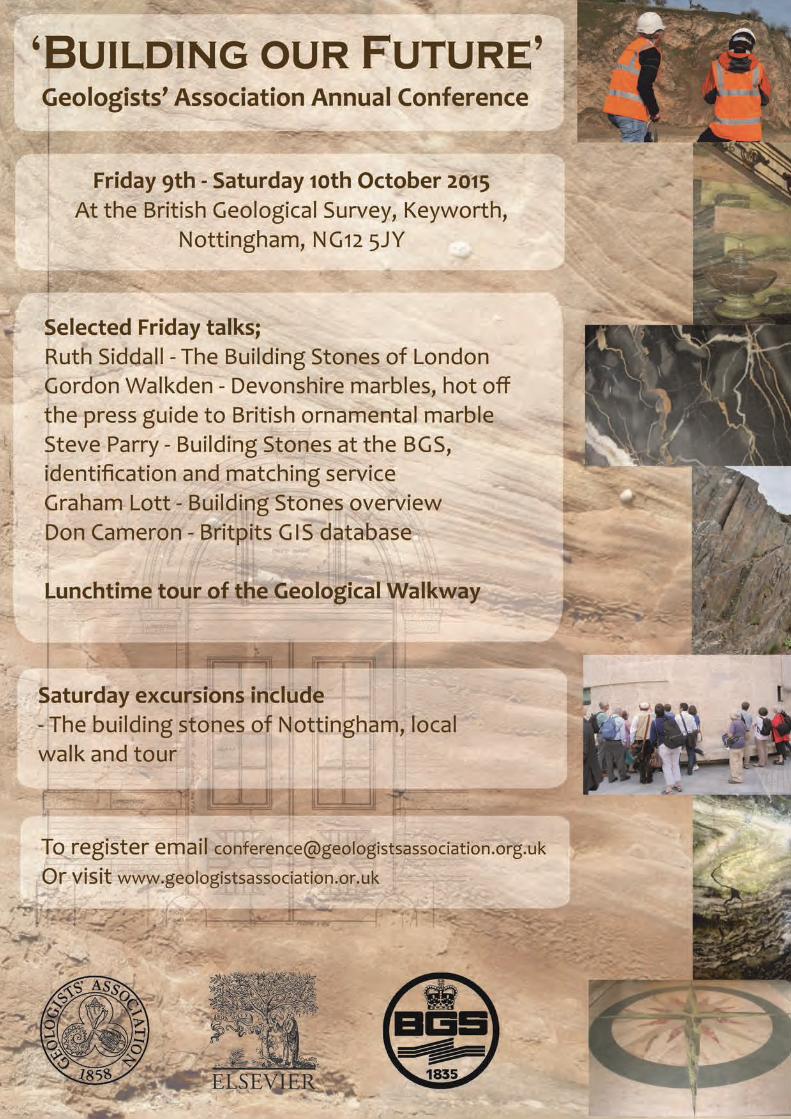
20084 GAMag March 2015 TOP COPY 26022015.qxp_mag41.qxd 05/03/2015 16:17 Page 24
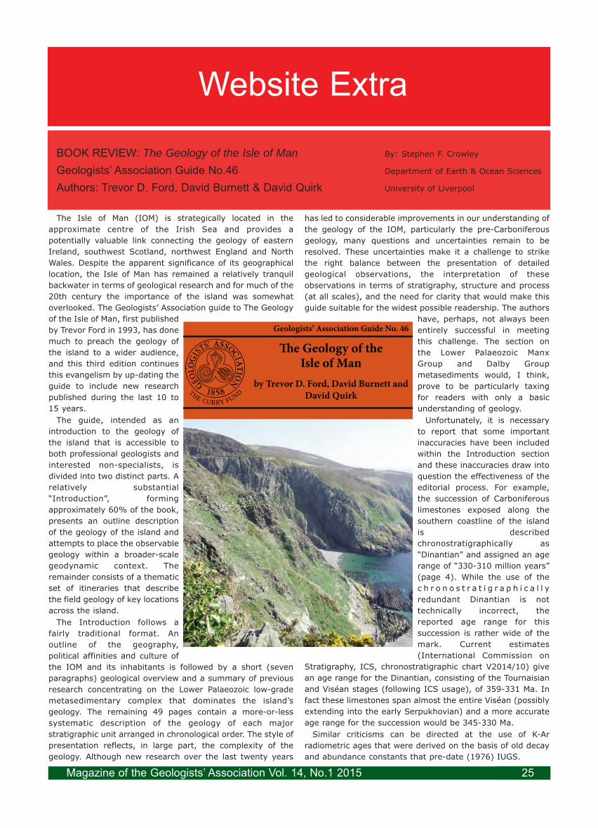
Website Extra
The Isle of Man (IOM) is strategically located in the
approximate centre of the Irish Sea and provides a
potentially valuable link connecting the geology of eastern
Ireland, southwest Scotland, northwest England and North
Wales. Despite the apparent significance of its geographical
location, the Isle of Man has remained a relatively tranquil
backwater in terms of geological research and for much of the
20th century the importance of the island was somewhat
overlooked. The Geologists’ Association guide to The Geology
of the Isle of Man, first published
by Trevor Ford in 1993, has done
much to preach the geology of
the island to a wider audience,
and this third edition continues
this evangelism by up-dating the
guide to include new research
published during the last 10 to
15 years.
The guide, intended as an
introduction to the geology of
the island that is accessible to
both professional geologists and
interested non-specialists, is
divided into two distinct parts. A
relatively substantial
“Introduction”, forming
approximately 60% of the book,
presents an outline description
of the geology of the island and
attempts to place the observable
geology within a broader-scale
geodynamic context. The
remainder consists of a thematic
set of itineraries that describe
the field geology of key locations
across the island.
The Introduction follows a
fairly traditional format. An
outline of the geography,
political affinities and culture of
the IOM and its inhabitants is followed by a short (seven
paragraphs) geological overview and a summary of previous
research concentrating on the Lower Palaeozoic low-grade
metasedimentary complex that dominates the island’s
geology. The remaining 49 pages contain a more-or-less
systematic description of the geology of each major
stratigraphic unit arranged in chronological order. The style of
presentation reflects, in large part, the complexity of the
geology. Although new research over the last twenty years
has led to considerable improvements in our understanding of
the geology of the IOM, particularly the pre-Carboniferous
geology, many questions and uncertainties remain to be
resolved. These uncertainties make it a challenge to strike
the right balance between the presentation of detailed
geological observations, the interpretation of these
observations in terms of stratigraphy, structure and process
(at all scales), and the need for clarity that would make this
guide suitable for the widest possible readership. The authors
have, perhaps, not always been
entirely successful in meeting
this challenge. The section on
the Lower Palaeozoic Manx
Group and Dalby Group
metasediments would, I think,
prove to be particularly taxing
for readers with only a basic
understanding of geology.
Unfortunately, it is necessary
to report that some important
inaccuracies have been included
within the Introduction section
and these inaccuracies draw into
question the effectiveness of the
editorial process. For example,
the succession of Carboniferous
limestones exposed along the
southern coastline of the island
is described
chronostratigraphically as
“Dinantian” and assigned an age
range of “330-310 million years”
(page 4). While the use of the
c h r o n o s t r a t i g r a p h i c a l l y
redundant Dinantian is not
technically incorrect, the
reported age range for this
succession is rather wide of the
mark. Current estimates
(International Commission on
Stratigraphy, ICS, chronostratigraphic chart V2014/10) give
an age range for the Dinantian, consisting of the Tournaisian
and Viséan stages (following ICS usage), of 359-331 Ma. In
fact these limestones span almost the entire Viséan (possibly
extending into the early Serpukhovian) and a more accurate
age range for the succession would be 345-330 Ma.
Similar criticisms can be directed at the use of K-Ar
radiometric ages that were derived on the basis of old decay
and abundance constants that pre-date (1976) IUGS.
BOOK REVIEW: The Geology of the Isle of Man By: Stephen F. Crowley
Geologists’ Association Guide No.46 Department of Earth & Ocean Sciences
Authors: Trevor D. Ford, David Burnett & David Quirk University of Liverpool
Geologists’ Association Guide No. 46
THE CURRY FUND
�e Geology of theIsle of Man
by Trevor D. Ford, David Burnett and David Quirk
Magazine of the Geologists’ Association Vol. 14, No.1 2015 25

recommendations. For example, on page 21, the K-Ar age
of the Foxdale granite is given as 374±7Ma and assigned to
the Early Devonian. This information is incorrect on both
counts. By adjusting the muscovite K-Ar age of Brown et al.
(1968) to modern constants (e.g. Dalrymple, 1979) a revised
date of 381±7 Ma. is obtained. This apparent intrusion age
would then, according to the ICS time-scale
(http://www.stratigraphy.org), straddle the Middle
Devonian/Late Devonian boundary. In fact it is highly
probable that the Foxdale granite is related to other (Early
Devonian) c. 400 Ma granites (e.g. Leinster, Shap, Weardale)
that were intruded along the northern margin of the East
Avalonian microcontinent during the Acadian orogenic event,
but the K-Ar date reported by Brown et al. (1968) does not
provide the required confirmation. Clearly most, if not all, of
the Manx K-Ar ages need to be revised since the
measurement data were produced prior to 1976. Even
corrected these dates are probably of limited
geochronological value, but if attention is drawn to such data
then the accuracy and significance of the dating evidence, in
terms of the timing of important events associated with the
geological evolution of the IOM, should be addressed
appropriately.
The “Itineraries” section consists of eight thematic sets of
field locations each focussing on a specific aspect of Manx
geology. The itineraries, although organised in general
geochronological order, are flexible and individual locations
within each itinerary could be visited separately without
necessarily compromising their overall geological
significance. The notes for each field location begin with clear
directions to the specified site and are followed by valuable
information on accessibility and tide-dependency. A generally
clear and concise description of the locality then draws the
attention of the reader to important geological features.
Itineraries covering the post-Lower Palaeozoic geology are
mostly accompanied by good quality maps and/or cross
sections that make it relatively simple to locate and
contextualise individual points of interest discussed in the
text. However, the same provision has not been made for
itineraries covering the Lower Palaeozoic metasediments and
Granites and Mines, and the written information conveyed in
these descriptions perhaps suffers accordingly. One general
point of criticism is the routine use of six-figure grid
references throughout. While six-figure grid references are
adequate to locate large sedimentary, igneous and tectonic
features, they may be insufficiently precise to enable the
inexperienced reader to find examples of smaller sedimentary
structures, fossils, minor igneous intrusions etc. mentioned
within the text. Easy access to reliable GPS location means
that potentially difficult-to-find features could be given eight
or even ten-figure grid references that should mitigate the
need for long and possibly fruitless searches.
The overall quality of the guide in terms of visual
appearance is generally excellent. The use of thick glossy
paper and the introduction of ring-binding make for a
relatively robust product that should survive the vagaries of
Manx weather, at least for a few years. However, the
production values are not without some criticism. For
example, the quality of some of the photographic images is
rather poor (e.g. Figures 14, 15 and 16), while other
photographs could usefully be annotated in order to make
their significance clear, particularly for the non-specialist
reader. Other photographs fail to illustrate specific features
with sufficient clarity; I would argue that even an
experienced reader might struggle to recognise the
bioturbation fabrics supposedly depicted in Figure 4 or the
deformation fabrics in Figure 51 and 52. In addition, the
value of the geological maps and cross sections illustrated in
the Introduction section would be greatly improved if they
were produced in colour. While colour figures would
undoubtedly add to the publication costs, the selective use of
colour would greatly improve the clarity and impact of the
geological information that they contain.
Finally, I feel that it would have been useful to include an
annotated geological time-scale to provide non-specialists
with a simple temporal frame of reference upon which hang
the geology described within the guide. The connection
between the rocks that we can see in the field and deep
geological time is one of the most immediate and thought
provoking aspects of Earth Science, particularly for students
and amateur geologists, and the addition of a time-scale
would be both useful and convenient. The usual objection to
the inclusion of a time-scale is that time-scales are under
constant revision and are always out-of-date. This was
undoubtedly true for much of the 20th century. While the
perfect time-scale has yet to be produced, most important
Phanerozoic time lines are now defined to a relatively high
degree of accuracy and precision so that future revisions are
unlikely to impact on the general utility of any modern time-
scale that might be included in this guide. If a geological
time-scale had been reproduced then it might have
prevented some of the evident chronostratigraphic and
geochronological errors discussed above.
Overall this guide offers a valuable and generally accessible
introduction to the field geology of the IOM and, with a few
reservations, I would recommend it to anyone interested in
exploring the island. In the hands of an experienced
professional geologist the guide would provide an excellent
basis for student field classes. However, I suspect that
amateur geologists and interested members of the non-
geological community might encounter some difficulties in
the absence of expert guidance. Clearly some improvements
could be made to make the guide more accessible to the
broadest possible readership. The addition of a short glossary
might prove to be particularly helpful in this respect. Perhaps
these improvements can be implemented in time for the 4th
edition which, if the current trend is followed, should be due
in 2023.
References
Brown, P.E., Miller, J.A. & Grasty, R.L. 1968. Isotopic ages
of late Caledonian granitic intrusions in the British Isles.
Proceedings of the Yorkshire Geological Society, 36, 261-276.
Dalrymple, G.B. 1979. Critical tables for the conversion of
K-Ar ages from old to new constants. Geology, 7, 558-560.
ISBN 978 0900717 79 6
Price: £10.00.
Magazine of the Geologists’ Association Vol. 14, No.1 201526

The Sunday trips have now been established as an integral
part of the GA Festival. This year there were 3 trips, 2 in
central London and the third visiting Chislehurst Caves with
an added bonus of Crystal Palace. All 3 trips were fully
booked several days before the Festival.
Diana Smith led a building stones walk around the Royal
Exchange area of the City (Figure 1). There was a downpour
just before the walk began but luckily the canopy of the
building provided some
protection for the start of the
walk. Diana brings an eclectic
mix of building stones and
history to her walks and this
one was no exceptions. Diana
is also an enthusiast about
many of the new buildings
that have appeared in recent
years and the group spent
time inspecting the base of
Tower 42.
We had a group booking for
Chislehurst Caves which
allowed us a maximum of 40
on the visit. Despite
Chislehurst Station being
closed that weekend, 37
people managed to get there.
We had a special trip led by a
local expert (archaeologist,
Rod Legear), assisted by our
President, Haydon Bailey, who
had been involved with
analysing chalk samples for
Chris Wood. The details are
described by Chris in GA Guide
68 (1). Haydon was able to
expand on individual questions
in the café at the end of the
trip. Several members of the
group took up the offer of an
add-on for the afternoon to
visit the Crystal Palace
Monsters which are only about
30 minutes away by car. Many
thanks to Joe Cain for meeting
them and guiding them
around. Joe led a trip there for us 2 years ago and enthralled
us with the ‘wow factor’ experienced by the Victorian visitors.
He and Ellinor Michel have since started a Friends of Crystal
Palace Dinosaurs in order to try and keep these Victorian
masterpieces conserved in their geological context (Figure 2).
You can become a Friend very simply through 'liking' the
FaceBook page (2). They will communicate with the 'Friends'
through social media as the plans develop. The ‘Geological
Illustrations’ of Crystal Palace Park (Doyle, 2012) gives
details for a self-guided walk (1).
The third trip was a walk I led around The lost waters of
Islington. This began at Farringdon Station, not far from the
Royal Exchange, so some people made a day of it. Luckily for
us the rain had stopped by then. The Crossrail works at
Farringdon have been included in the Geological Society list
of 100 Great Geosites (Industrial & economic importance:
www.geolsoc.org.uk/100geosites) so, although not strictly
relevant, it seemed appropriate to start with the geology
beneath our feet and the huge
advances that have been
made about faults in the area
(3). The Tunnel Boring
Machines from both directions
are due to come to the surface
at Farringdon which lies
directly over the River Fleet.
The intensive ground
excavations seem to have paid
off and the Fleet has not burst
its bank the way it did in 1862
before the first Farringdon
Station was opened. The Fleet
has cut a deep valley down
Farringdon Road and what has
become apparent from the
new data is the considerable
amount of ‘made ground’
above the original riverbed –
up to 12 metres in places.
Other clues to the Fleet lie in
the street names eg Turnmill
Street, Cowcross Street. An
early map dated 1638 (4)
shows springs emanating from
the eroded graving tipping into
the Fleet. One spring was
appropriately named
Horsepool and was situated in
Smithfield Market, another,
Clerk’s Well, is still visible
through a large window,
incorporated into 14-16
Farringdon Lane (Figure 3).
The river itself is now part of
the Bazalgette sewer system
and we were able to listen to
water flowing through that in Ray Street.
The proximity of Smithfield explains the large number of
breweries and distilleries that used to exist in the area. None
remain but the lovely frieze in Britton Street was formerly on
the walls of Booths Gin distillery when it was in Turnmill
Street and acts as a reminder. Water was originally taken
from the gravels but as they became polluted wells were sunk
first to the Thanet Sand and then to the Chalk, London’s
aquifer.
Festival of Geology 2014; Field Excursions 2nd November, 2014
Diana Clements
Figure 2: The Coal Measures cliff in Crystal PalacePark in 2010; restoration work is more urgent now
Figure 1: Royal Exchange in the sunshine July 2014
Magazine of the Geologists’ Association Vol. 14, No.1 2015 27

Field Meeting Report: Field Meeting Report: Lisbon: MuseumsLisbon: Museums 17th October, 201417th October, 2014
Leader: Prof. Miguel Ramalho & Joanna ReisLeader: Prof. Miguel Ramalho & Joanna Reis Report: Richard TrounsonReport: Richard Trounson
Magazine of the Geologists’ Association Vol. 14, No.1 201528
Islington was once famous for its Spas
and Tea Gardens. The water for these came
from the gravels and was termed
‘chalybeate’ owing to the presence of iron.
We passed London Spa, Islington Spa and
the more famous Sadler’s Wells on our way
to the final destination, New River Head. In
1613 the New River was opened, bringing
spring water from Chadwell in Hertfordshire
to the Round Pond adjacent to Sadler’s
Wells on the 100 foot terrace overlooking
London. Water was fed by gravity to the
City from the Round Pond in elm pipes. The
New River was originally 40 miles long and
over that distance only dropped 18 feet, an
amazing feat in the early 1600s. We
finished at the small visitor information
point which marks the end of the New River
Walk (5), overlooking the building housing
the pumps from the modern Thames Water
Ring Main that supplies London, and the
1913 Thames Water offices, now residential apartments. This
is on the site of the 1613 building and the shape of the Round
Pond can still be made out surrounding the apartments.
References
(1) GA Guide No. 68, 2012 The Geology of London compiled
by Diana Clements. Itinerary 7 (Chislehurst Caves) and 9
(The Geological Illustrations of
Crystal Palace Park) are available
as a pdfs through the GA website.
(2) Friends of Crystal Palace
Dinosaurs:
http://cpdinosaurs.org/
https://www.facebook.com/
CPdinos
https://twitter.com/cpdinosaurs
(3) Aldiss, D.T.; Black, M.G.;Entwisle, D.C.; Page, D.P.;
Terrington, R.L.. 2012 Benefits of a
3D geological model for major
tunnelling works : an example from
Farringdon, east-central London,UK. Quarterly Journal of
Engineering Geology and
Hydrogeology, 45 (4). 405-414.10.1144/qjegh2011-066
(4) Map of the Fleet, signed JE
1638, available on microfiche from Camden Local History
library and authenticated by the Guildhall (although the
paper was from a later date).
(5) Thames Water publish a New River Path booklet:
www.thameswater.co.uk/17250.htm
Figure 3: The Clerk’s Well, as seenthrough the window of 14-16
Farringdon Lane
Friday was the day assigned for our Museum visits, and we
set off after breakfast, some of us on foot, others by taxi, for
the Geological Museum. We were welcomed by the Director,
Professor Miguel Ramalho. Professor Ramalho explained that
the Museum, which was located, like many public buildings in
Lisbon, in a former convent, had been established in the
1850s, about the same time as the Portuguese Geological
Survey. The original collection had been contributed to by
many of the founder members of the Survey. It had been
considerably augmented in the 1930s, and the explanatory
material had been subsequently updated.
However, Portugal was passing through periods of
economic austerity in the latter half of the last century when,
in other parts of Europe, many museums had been
transformed. In consequence the museum still retained for
the most part its 19th century ambience, and could rightly be
described as a "museum of museums". We were then free to
walk round the galleries at our leisure.
There was a Lisbon room, in which the collection was
devoted to the geological record of the last 100 million years
in the region surrounding the city, with a particular emphasis
on the volcanism which took place in the area between 75-72
Ma., and on Miocene fossils. This display also contains
vertebrate fossils from the end of the Tertiary in the Lisbon
region, which at that time had a rich mammalian fauna.
To one side off the Lisbon Room was a long gallery devoted
to the Geological Evolution of the Portuguese Territory, and
the main paleontological displays. In effect this contained the
greater part of the geological collections of the museum on
public display, with sections devoted to particular geological
periods and how these are represented in the geology of
Portugal. There were extensive collections of vertebrate
fossils, including dinosaur fossils, and also invertebrate and
trace fossils, the last category including a couple of
particularly fine specimens of Cruziana. There were also
thematic sections, devoted to particular topics such as
Eileen BennettEilleen Bennett passed away on 9 February 2015. She had been a GA member since 1977. She did not heal properly after
an operation last summer to remove a cancerous growth in her abdomen. She had been transferred to the North London
Hospice because the Hospital could do nothing more for her. In addition to being into Geology for many years (she went
to Iceland with John Potter in the old "primitive" days when he was researching his GA Guide), she was also an
accomplished photographer and was President of the Southgate Photographic Society for many years. She was also a keen
gardener. She had kept up all her interests into her early 80's and actually drove me all the way up the A1 to the
Geddington and Barnack area on a John Potter field trip about 4 years ago before she got ill, when we were both attending
his classes in Hammersmith. By: Sue jacobs

Fossilisation, Living Fossils, and Pseudo-fossils. At one end
of this gallery were four cases devoted to the principal types
of rock found in Portugal. However this was only one part of
the extensive lithological and mineralogical collection, most
of which is not accessible to the public.
There was a further long gallery opening off the Lisbon
Room, containing the Portuguese Pre-History collection. In
effect the museum is an archaeological, as well as a
geological, museum apparently because the Portuguese
Geological Survey also interested itself in archaeology, so this
gallery contained extensive
collections of tools and other
human artefacts, particularly
from the Lisbon region, as well as
other evidences of human
settlements and burials in
Portugal, ranging from the early
Palaeolithic to the Roman period.
Beyond the Pre-History gallery
lay a modern mineralogical room,
in quite different style from the
rest of the museum. This
contained specimens from sites in
Portugal, such as the tin and
tungsten mine at Panasqueira, in
the Estrela mountains (which
some of us had visited some
three years previously on a trip
organised by the London Branch
of the Open University Geological
Society), and also from the Neves
Corvo zinc-copper mine in the
Alentejo. However, thanks to the
generosity of a number of mining
companies in other countries,
there are also fine mineralogical
specimens from all over the world. This area also contains a
small display of historic field and geochemical instruments
used by members of the Geological Survey. In a further
room, the Museum had assembled materials on the life and
career of Joaquim Nery Delgado, a 19th century military
engineer who became one of the pioneers of the Portuguese
Geological Survey, and who was raised to the rank of General
of Division (approximately a major-general) in recognition of
his work.
Having thanked our hosts, we made our way, on foot or by
taxi, to our next stop, the National Museum of Natural History
and Science. This had originally been a Jesuit college and
novitiate, and a buffet lunch had been laid on for us to eat in
what had originally been the cloisters. Some of us then
viewed a most interesting exhibition, "Form and Formula", on
the curves and shapes described by quadratic and higher-
order equations. We re-assembled in the entrance hall,
formerly the chapel of the College. Despite extensive re-
construction, the characteristic proportions of a Jesuit church
were still evident. In what had been a side chapel stood the
former tomb of a patron of the College. He had been a
Viceroy of the Portuguese Indies, and the tomb was
supported by elephants, like the royal tombs in the Jerónimos
monastery at Belém, which some of us were to see on the
following Sunday.
We were addressed by the Director of the Museum,
Professor José Sousa Dias. He explained that the museum
buildings had always been connected with the natural
sciences; when it functioned as a Jesuit novitiate, there had
been a school of mathematics and astronomy for training
missionaries. The Jesuits had however been expelled by the
Marques de Pombal, the 18th century prime minister,
"Enlightenment" figure, and effective dictator of the country,
after whom the hotel where we were staying, which was
located near his monument, was named. Pombal, whose
power as the chief royal minister had been consolidated after
his highly effective response to the 1755 earthquake, and the
ensuing fires and tsunami, then
tried to use the buildings and
assets as a College of Nobles.
This was to be a school for
providing a modern and technical
education for the sons of the
lesser nobility, who would then
serve the state (Pombal himself
came from that class, and had
purged many of the greater
nobility who had been his political
opponents). However, the
venture was not a success, and
when it was disbanded, the
scientific instruments were sent
to the University of Coimbra.
In the 19th century a
Polytechnic School had been
established in the Jesuit college.
This provided secondary and
tertiary education for future
officers of the technical and
scientific branches of the military,
and also for some civilians. The
school had acquired the natural
history and botanical collections
originally established at the Royal Palace at Ajuda during the
19th century. In 1911 the young First Republic, established
after the overthrow of the monarchy the previous year,
created a new University at Lisbon as part of efforts to
transform Portuguese society, and School and Museum were
transferred to its Science Faculty. The Museum and Faculty
had subsequently been administered together, but after a
disastrous fire in 1978, which had destroyed much of the
buildings and collections, the Faculty had largely moved
elsewhere. The Museums of Natural History and Science now
had an autonomous status within the university, and
supported research centres in maths, physics, chemistry,
geology and biology.
We were taken up to some galleries illustrating the history
of the museum, and then down to the restored 19th century
Chemical Laboratory and Lecture Theatre, perhaps the only
surviving example of its kind. It had been used for chemical
demonstrations and experiments when the Director, an
academic pharmacist now turned historian of science, was an
undergraduate. It is now mainly used for public lectures and
events, and some university ceremonies. Having split into
two smaller groups, we were then taken in turn on a tour of
parts of the museum's public galleries which were of
specifically geological interest. In particular, we saw:
Educational galleries on Life on Earth and Dinosaurs for
School visits; An exhibition on the story of the discovery of
Allosaurus remains at a quarry at Andrés in west-central
Magazine of the Geologists’ Association Vol. 14, No.1 2015 29
Figure 1: Lisbon Musuem interior
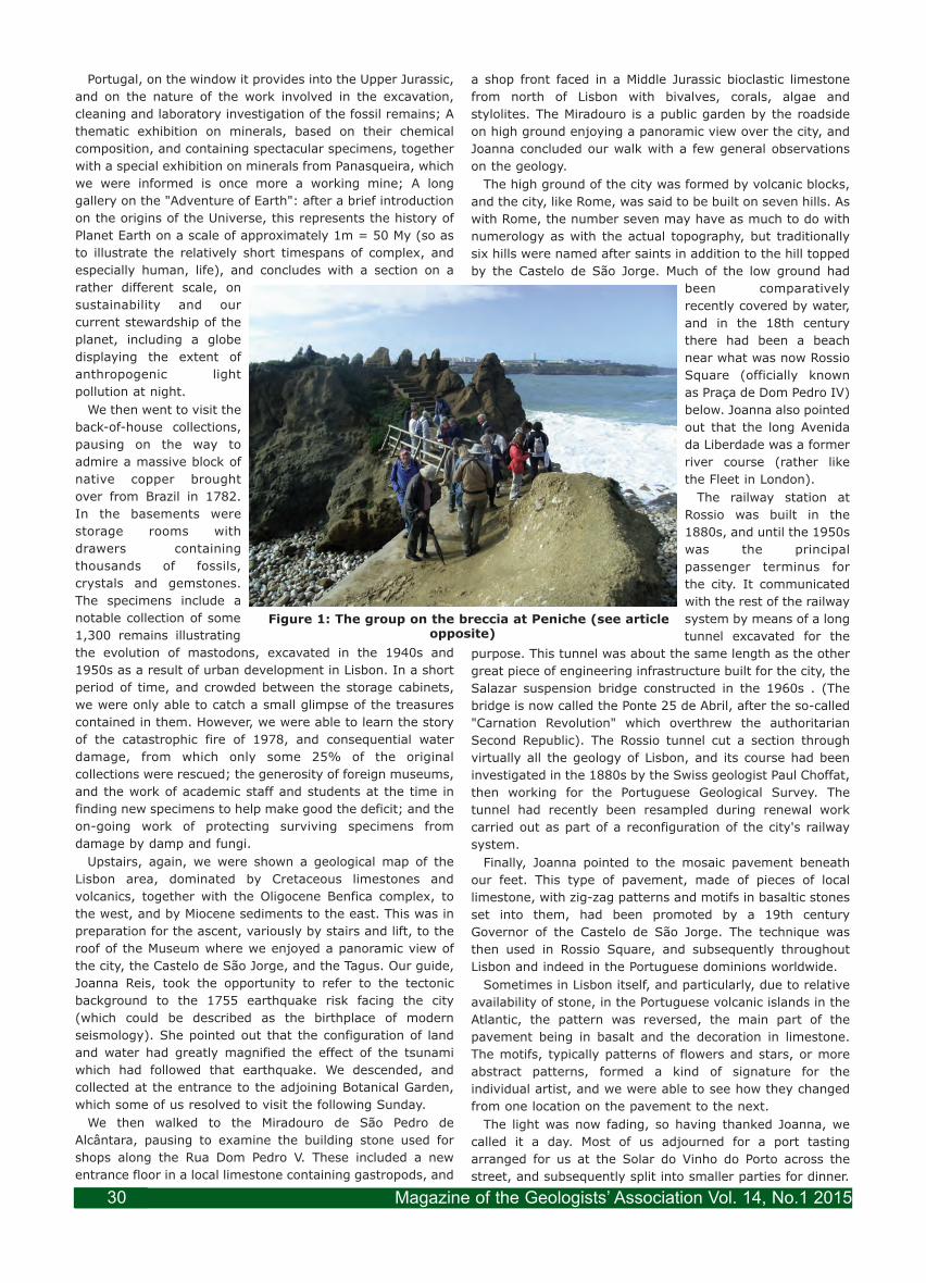
Portugal, on the window it provides into the Upper Jurassic,
and on the nature of the work involved in the excavation,
cleaning and laboratory investigation of the fossil remains; A
thematic exhibition on minerals, based on their chemical
composition, and containing spectacular specimens, together
with a special exhibition on minerals from Panasqueira, which
we were informed is once more a working mine; A long
gallery on the "Adventure of Earth": after a brief introduction
on the origins of the Universe, this represents the history of
Planet Earth on a scale of approximately 1m = 50 My (so as
to illustrate the relatively short timespans of complex, and
especially human, life), and concludes with a section on a
rather different scale, on
sustainability and our
current stewardship of the
planet, including a globe
displaying the extent of
anthropogenic light
pollution at night.
We then went to visit the
back-of-house collections,
pausing on the way to
admire a massive block of
native copper brought
over from Brazil in 1782.
In the basements were
storage rooms with
drawers containing
thousands of fossils,
crystals and gemstones.
The specimens include a
notable collection of some
1,300 remains illustrating
the evolution of mastodons, excavated in the 1940s and
1950s as a result of urban development in Lisbon. In a short
period of time, and crowded between the storage cabinets,
we were only able to catch a small glimpse of the treasures
contained in them. However, we were able to learn the story
of the catastrophic fire of 1978, and consequential water
damage, from which only some 25% of the original
collections were rescued; the generosity of foreign museums,
and the work of academic staff and students at the time in
finding new specimens to help make good the deficit; and the
on-going work of protecting surviving specimens from
damage by damp and fungi.
Upstairs, again, we were shown a geological map of the
Lisbon area, dominated by Cretaceous limestones and
volcanics, together with the Oligocene Benfica complex, to
the west, and by Miocene sediments to the east. This was in
preparation for the ascent, variously by stairs and lift, to the
roof of the Museum where we enjoyed a panoramic view of
the city, the Castelo de São Jorge, and the Tagus. Our guide,
Joanna Reis, took the opportunity to refer to the tectonic
background to the 1755 earthquake risk facing the city
(which could be described as the birthplace of modern
seismology). She pointed out that the configuration of land
and water had greatly magnified the effect of the tsunami
which had followed that earthquake. We descended, and
collected at the entrance to the adjoining Botanical Garden,
which some of us resolved to visit the following Sunday.
We then walked to the Miradouro de São Pedro de
Alcântara, pausing to examine the building stone used for
shops along the Rua Dom Pedro V. These included a new
entrance floor in a local limestone containing gastropods, and
a shop front faced in a Middle Jurassic bioclastic limestone
from north of Lisbon with bivalves, corals, algae and
stylolites. The Miradouro is a public garden by the roadside
on high ground enjoying a panoramic view over the city, and
Joanna concluded our walk with a few general observations
on the geology.
The high ground of the city was formed by volcanic blocks,
and the city, like Rome, was said to be built on seven hills. As
with Rome, the number seven may have as much to do with
numerology as with the actual topography, but traditionally
six hills were named after saints in addition to the hill topped
by the Castelo de São Jorge. Much of the low ground had
been comparatively
recently covered by water,
and in the 18th century
there had been a beach
near what was now Rossio
Square (officially known
as Praça de Dom Pedro IV)
below. Joanna also pointed
out that the long Avenida
da Liberdade was a former
river course (rather like
the Fleet in London).
The railway station at
Rossio was built in the
1880s, and until the 1950s
was the principal
passenger terminus for
the city. It communicated
with the rest of the railway
system by means of a long
tunnel excavated for the
purpose. This tunnel was about the same length as the other
great piece of engineering infrastructure built for the city, the
Salazar suspension bridge constructed in the 1960s . (The
bridge is now called the Ponte 25 de Abril, after the so-called
"Carnation Revolution" which overthrew the authoritarian
Second Republic). The Rossio tunnel cut a section through
virtually all the geology of Lisbon, and its course had been
investigated in the 1880s by the Swiss geologist Paul Choffat,
then working for the Portuguese Geological Survey. The
tunnel had recently been resampled during renewal work
carried out as part of a reconfiguration of the city's railway
system.
Finally, Joanna pointed to the mosaic pavement beneath
our feet. This type of pavement, made of pieces of local
limestone, with zig-zag patterns and motifs in basaltic stones
set into them, had been promoted by a 19th century
Governor of the Castelo de São Jorge. The technique was
then used in Rossio Square, and subsequently throughout
Lisbon and indeed in the Portuguese dominions worldwide.
Sometimes in Lisbon itself, and particularly, due to relative
availability of stone, in the Portuguese volcanic islands in the
Atlantic, the pattern was reversed, the main part of the
pavement being in basalt and the decoration in limestone.
The motifs, typically patterns of flowers and stars, or more
abstract patterns, formed a kind of signature for the
individual artist, and we were able to see how they changed
from one location on the pavement to the next.
The light was now fading, so having thanked Joanna, we
called it a day. Most of us adjourned for a port tasting
arranged for us at the Solar do Vinho do Porto across the
street, and subsequently split into smaller parties for dinner.
Figure 1: The group on the breccia at Peniche (see articleopposite)
Magazine of the Geologists’ Association Vol. 14, No.1 201530

Field Meeting Report: Field Meeting Report: Lisbon; Peniche CoastLisbon; Peniche Coast 18th October, 201418th October, 2014
Leader: Dr. Luis DuarteLeader: Dr. Luis Duarte Report: John LonerganReport: John Lonergan
This, now traditional, Geologists’ Association bi-annual
European museum excursion (organised by David and Anne
Bone), was to Lisbon. This included the now traditional field
trip (to see geology in its
natural habitat, after
viewing it caged in
museums). The field trip
was by coach on Sunday
18th October 2014. It was
in two very different halves,
a morning on the Peniche
coast (reported herein)
looking at geology in
outcrop, and then, after
lunch, a memorable visit to
the Green Lines of the
Peninsula War (reported by
Barry Hall; see article
below).
In the morning the coach
took us to Peniche. This is
on the Portuguese Coast
and fifty miles north of
Lisbon. For the morning we
were led by Dr Luis Duarte of the
University of Coimbra, whose
research uses isotopes to
understand this area of turbidites
and peri-marginal environments.
Peniche is now a peninsula, but
was an island until the 14-15th
centuries. It is a monoclonal
carbonate succession from the
lower to lowermost middle Jurassic.
This area is particularly important
as it records the sedimontological
evolution and stratigraphy of the
Lusitanian Basin, and has been
proposed for the location of the
golden spike marking the base of
the Toarcian. It also hosts an
unusual volcanic breccia, which was
our first location.
This was at Papoa, with striking
cliffs, blue skies, brilliant sunshine,
strong winds and impressive surf.
After an explanation of the geology
in the shelter of the coach, we got
out to investigate the narrow
section joining the headland to
Papoa, here are two parallel faults
in the limestone, and between
them, in the graben, are breccia and weathered tuff from a
pyroclastic eruption, including rock fragments of a large size
range, including basalt, granite gneiss, quartzite, limestone
and volcanic bombs. This is interpreted as the preserved part
of a collapsed volcanic cone, and correlated with late
Cretaceous volcanism in the Lisbon – Sintra region.
From here on we explored the Lower Jurassic of the
Lusitanian Basin, as on this
peninsula are found three
second order
transgressive-regressive
facies cycles, which can be
correlated across the basin.
Our second stop was on the
adjacent Abalo beach, to
examine the organic rich
black shales of the marly
limestones, with the
bituminous facies member
of the Vale das Fontes
Formation, with many
ammonites but no benthic
fauna, possibly due to an
oceanic anoxic event. This
is considered a main
hydrocarbon source
potential in the West
Iberian Margin.
Unfortunately the rock is
insufficiently mature, and has
yielded no recoverable reserves.
Our third stop was to see the
Toarcian Global Stratigraphic
Staging Point for the base of the
Toarcian (See Front Cover photo).
While this was named after Tours in
France, this location has a more
complete succession, though there
is still international competition for
the honour. Its importance comes
from the presence of ammonites
from both Tethys and the Northern
Atlantic.
Next we stopped at Cabo
Carvoeiro to examine the topmost
Jurassic to lowermost Middle
Jurassic shallower marine
limestones. On top of the Cabo
Carvoeiro Formation is a thick
succession of detrital oosparites
and grainstones, rich in bivalves,
gastropods, crinoids and
ahermatipic corals. This is typical
of a shallow water environment,
and the top of this marks a second
order regressive event at basin
scale. This part of the coast has striking karst limestone
scenery, see Figure 2.
Then off to a considerable lunch at O Febras, and south for
the afternoon.
Magazine of the Geologists’ Association Vol. 14, No.1 2015 31
Figure 1: The coast at Peniche
Figure 2: Karst at Cabo Carvoeiro

After lunch at Peniche we travelled South to visit the
modern City (1979) of Torres Vedras, just 30 miles to the
north of Lisbon and situated on the Rio Sizandro with a
resident population of some 25000, which
was a pivotal site in the swaying fortunes of
the Peninsula Wars of 1808 to 1814.
In 1809 Brittania ruled the waves but
Napoleon ruled just about everywhere else in
Europe and was set on acquiring Portugal, a
British ally, after marching his victorious
armies into Madrid and proclaiming his
brother Joseph 'King of Spain'. Sir Arthur
Wellesley, contemptuously dismissed by
Napoleon as nothing more than a 'Sepoy
General' following his early career in India,
was sent with a small army to defend Portugal
and help rally the Portugese and Spanish
Armies. The modus operandi of the opposing
forces could not have been more different.
Napoleonic armies lived off the conquered
land, taking food and forage wherever found
and destroying buildings and cottages for the
timber to feed camp fires and thus fueling
Portugese resentment. In contrast Allied
armies were paid, equipped and fed by
seaborne supplies courtesy, ultimately, of the
British taxpayer.
Following previous victories at Rolica,
Vimerio and then Talavera in July 1809, after
which Sir Arthur became Viscount Wellington,
he was nevertheless forced to retreat towards
Lisbon due to the numerical strength of the
French armies. Ever prudent and in great
secrecy, conscious that his army was all
Britain had in the field and with the approach
of winter reducing hostilities, Wellington
instructed his Chief Engineer, Lieutenant-
Colonel Richard Fletcher, to construct two
major lines of defence from the Atlantic to the
Tagus river, severing the roads to Lisbon and
providing a haven for the peasantry from the
advancing French, commanded by Massena,
who unknowingly were marching into an area
of 'scorched earth' demanded by Wellington.
The underlying complex geology, with Upper
Jurassic and Lower Cretaceous outcrops,
shaped a mountainous terrain with numerous
hilltops along the length of the lines upon
which were built 152 Forts and 678 Redoubts
(defensive 'outliers'). Dams were also
constructed which could have flooded the
river valleys if needed. To the west of Lisbon
were a further two small fortifications
designed to protect any necessary
embarkation. Although Wellington had no
intention of abandoning Portugal, as a wary
population suspected, he had every intention of saving his
army if events went badly.
These events were highlighted during our visit to the Torres
Vedras Municipal Museum and by our
eloquent gentleman guide Paulo Ferreira from
city hall. Of particular interest was the ox cart
(Figure 1), beautifully preserved, which was
the sole means of transporting bulk
throughout the Peninsula, capable of pulling
up to 2 tonnes at 2 kilometres per hour, a
calculation ever present in Wellington's mind.
Nearly all memoirs of Peninsula veterans say
their abiding memory of the war was the
unremitting squeal of the axles. Also of major
importance were the signalling masts by
which messages could be sent the length of
the lines, 27 miles, in just 7minutes. Leaving
the museum, Paulo took us to see Fort Sao
Vicente, high above Torres Vedras and
guarding the road from Leiria to Lisbon,
beautifully preserved from a conservation
viewpoint with the earth banks, embrasures,
ditches, and windmills converted to powder
stores, all in excellent condition. Of interest
was a re-enactor (Figure 2) dressed in the
period uniform of a Cameron Highlander
although, alas, not of period girth!
The surprise was complete. Massena,
complaining that he had not been told of the
mountains, let alone the fortifications,
stomped about for several months on ground
Wellington said he could not have maintained
his army one week. His subsequent retreat
North marked the beginning of the end for
Napoleon's domination of Europe. Wellington
eventually forced the Pyrenees and captured
Toulouse before a hiatus in fighting ended
with the climactic battle at Waterloo in 1815.
Our day ended with a visit to the viewpoint
high above the Sizandro River mouth and
beach where Ana Azeredo and Alan Lord
detailed the significance of their research into
Holocene post glacial environmental changes
in the Rio Sizandro valley using abundant
Ostracods from two core samples.They were
able to track sea level rise and stabilisation,
then sediment in-fill following deforestation
and human agricultural activity.
References and further reading:
Faculdade de Ciencias, Departamento de
Geologica, Lisbon, Field Trip Guide, Oct. 2014
The Duke. Philip Guedala, Hodder and
Stoughton
Life of Wellington. Sir Herbert Maxwell,
Sampson Low, Marston and Company
Wellington. Richard Holmes, Harper Collins.
Field Meeting Report: Field Meeting Report: Lisbon; The Lines of Torres Vedras Lisbon; The Lines of Torres Vedras 18th October, 201418th October, 2014
Leader: Paulo FerreiraLeader: Paulo Ferreira Report: Barry HallReport: Barry Hall
Figure 1: Ox Cart
Figure 2: CameronHighlander re-enactor
Figure 2: NunneryCourtyard: Torres Vedras
Museum
Magazine of the Geologists’ Association Vol. 14, No.1 201532
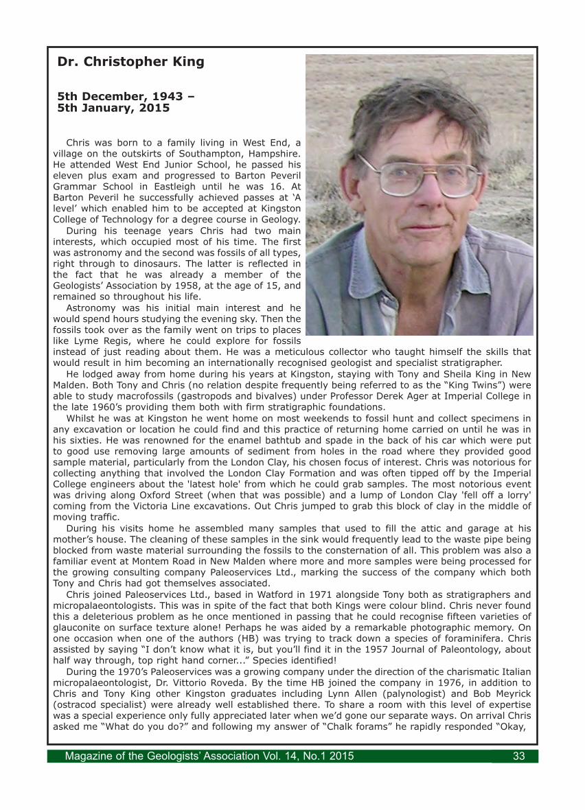
Dr. Christopher King
5th December, 1943 – 5th January, 2015
Chris was born to a family living in West End, avillage on the outskirts of Southampton, Hampshire.He attended West End Junior School, he passed hiseleven plus exam and progressed to Barton PeverilGrammar School in Eastleigh until he was 16. AtBarton Peveril he successfully achieved passes at ‘Alevel’ which enabled him to be accepted at KingstonCollege of Technology for a degree course in Geology.
During his teenage years Chris had two maininterests, which occupied most of his time. The firstwas astronomy and the second was fossils of all types,right through to dinosaurs. The latter is reflected inthe fact that he was already a member of theGeologists’ Association by 1958, at the age of 15, andremained so throughout his life.
Astronomy was his initial main interest and hewould spend hours studying the evening sky. Then thefossils took over as the family went on trips to placeslike Lyme Regis, where he could explore for fossilsinstead of just reading about them. He was a meticulous collector who taught himself the skills thatwould result in him becoming an internationally recognised geologist and specialist stratigrapher.
He lodged away from home during his years at Kingston, staying with Tony and Sheila King in NewMalden. Both Tony and Chris (no relation despite frequently being referred to as the “King Twins”) wereable to study macrofossils (gastropods and bivalves) under Professor Derek Ager at Imperial College inthe late 1960’s providing them both with firm stratigraphic foundations.
Whilst he was at Kingston he went home on most weekends to fossil hunt and collect specimens inany excavation or location he could find and this practice of returning home carried on until he was inhis sixties. He was renowned for the enamel bathtub and spade in the back of his car which were putto good use removing large amounts of sediment from holes in the road where they provided goodsample material, particularly from the London Clay, his chosen focus of interest. Chris was notorious forcollecting anything that involved the London Clay Formation and was often tipped off by the ImperialCollege engineers about the 'latest hole' from which he could grab samples. The most notorious eventwas driving along Oxford Street (when that was possible) and a lump of London Clay 'fell off a lorry'coming from the Victoria Line excavations. Out Chris jumped to grab this block of clay in the middle ofmoving traffic.
During his visits home he assembled many samples that used to fill the attic and garage at hismother’s house. The cleaning of these samples in the sink would frequently lead to the waste pipe beingblocked from waste material surrounding the fossils to the consternation of all. This problem was also afamiliar event at Montem Road in New Malden where more and more samples were being processed forthe growing consulting company Paleoservices Ltd., marking the success of the company which bothTony and Chris had got themselves associated.
Chris joined Paleoservices Ltd., based in Watford in 1971 alongside Tony both as stratigraphers andmicropalaeontologists. This was in spite of the fact that both Kings were colour blind. Chris never foundthis a deleterious problem as he once mentioned in passing that he could recognise fifteen varieties ofglauconite on surface texture alone! Perhaps he was aided by a remarkable photographic memory. Onone occasion when one of the authors (HB) was trying to track down a species of foraminifera. Chrisassisted by saying “I don’t know what it is, but you’ll find it in the 1957 Journal of Paleontology, abouthalf way through, top right hand corner...” Species identified!
During the 1970’s Paleoservices was a growing company under the direction of the charismatic Italianmicropalaeontologist, Dr. Vittorio Roveda. By the time HB joined the company in 1976, in addition toChris and Tony King other Kingston graduates including Lynn Allen (palynologist) and Bob Meyrick(ostracod specialist) were already well established there. To share a room with this level of expertisewas a special experience only fully appreciated later when we’d gone our separate ways. On arrival Chrisasked me “What do you do?” and following my answer of “Chalk forams” he rapidly responded “Okay,
Magazine of the Geologists’ Association Vol. 14, No.1 2015 33

you can have Denmark!”I shared a room with Chris for almost twelve years and I have to mention his incessant puns; anyone
close to him will remember the groans that followed his word play and ability to twist anything said intoan amusing alternative.
Chris had such an intimate knowledge of the London Clay that during 1980 he wrote virtually all of amanuscript for what became a 158 page Tertiary Research Group publication entitled “The Stratigraphyof the London Clay and associated deposits” during what he described as a “period of enforced inactivity”sitting in the middle of the North Sea on the oil rig Deep Sea Saga.
Throughout his time at Paleoservices, which lasted until 1992, Chris was still using the bathtub outof the back of his Citroen estate car to collect inordinate amounts of London Clay and associatedsediments. He managed with the amazing assistance of his research supervisor, Prof. Dick Moody, bynow at the University of Kingston, to maintain his registration for his Ph.D. at the university over anestimated period of twenty two years (three seven year registration periods plus). Finally, in 1991, histhesis entitled “The Stratigraphy of the London Clay Formation in the Hampshire Basin” was acceptedand he was duly acknowledged for all the time, in depth research and sink blockages which had goneinto this excellent study.
Completion of this work and his parting from Paleoservices, which had been taken over by a totallynew management marked a new phase of Chris’s career. First he moved to Bridport and from here hespent some years working as a wellsite biostratigrapher working in the North Sea, North Africa,Venezuela and the UK onshore. He frequently worked on the South Arne Field in offshore Denmark. Thisincluded numerous travel escapades including at least one journey via Hamburg where he rented a taxiand had to direct the driver how to drive to Esbjerg. When Network Stratigraphic negotiated the wellsitecontract for this field they were asked how they would man the increased work load. The response wasthat they had additional staff involved, one of whom was Dr. Chris King. At this point there was a sharpintake of breath from one of the junior geologists who queried “The Chris King”? When they gave her apositive response her awe was maintained and she said “In Aarhus where I come from, Chris King is aGod”.
His research on Tertiary stratigraphy, biostratigraphy and depositional environments across Europe,the USA, Egypt, Israel, the Ukraine, Kazakhstan and Uzbekistan attracted hundreds of online followersthrough ResearchGate and Academia. He also worked on the Jurassic stratigraphy of the UK and theCretaceous in Kazakhstan and Uzbekistan. He collaborated with colleagues in the UK, Belgium, Denmark,Egypt, France, Israel, Netherlands, Norway, Russia and the USA. He was a former Chairman of the IGCPRegional Committee on Northern Paleogene Stratigraphy and a Member of the IGCP Paleocene-EoceneBoundary Working Group. Perhaps some of his greatest geomemories were generated on jointexpeditions to Niger with colleagues from Kingston University and the Natural History Museum.
By 2000 he was moving into the world of engineering geology due to his expertise in the London Clay.He started to teach courses covering the London Clay and the Harwich Formation to engineeringgeologists through the Natural History Museum with Jackie Skipper. These courses soon becameproscribed for staff working on Crossrail and the Thames Tideway projects, and in some years thecourses were repeated several times, often followed by days of checking delegate’s logging abilities andthe subsequent borehole logs produced. Chris had endless patience and quiet enthusiasm for explainingthe subtle variations in London Clay cores and the seemingly bizarre variations in the Harwich Formation.
Hundreds of people have attended the courses since they started and they have fundamentallychanged and improved how the London Clay and Harwich Formation are logged in site investigationsacross southeast England. Chris also collaborated with other workers, particularly back at his oldstamping ground of Imperial College, but now in Civil Engineering with Jamie Standing and David Hight.They had been researching the behaviour of the London Clay and had noted how engineering propertieschanged consistently with Chris’s stratigraphic boundaries. Chris’ input into the interpretation of theground around tunnelling projects has subsequently greatly increased the understanding of how LondonClay behaves and how it can be engineered.
Chris was a key member of the London Basin Forum which was a group of geologists brought togetherby Mike de Freitas and working towards the production of an Atlas of London Geology for use in futureprojects around the capital. He published over 70 research papers.
Chris will be sorely missed by all those people his life has touched; he is survived by his wife Pat,three younger brothers David, Robert and Raymond and his mother Joan.
Compiled by Haydon Bailey, Dick Moody, Jackie Skipper, David Ward, with assistance from RossSandman, David King, Malcolm Hart and Graham Williams.
Magazine of the Geologists’ Association Vol. 14, No.1 201534

This GA field meeting comprised 22 members; we had
received in advance a guidebook which described New
Zealand’s tectonically-active history. The country was
attached to Australia until about mid-Cretaceous times when
it detached and drifted east, at first with few signs of any
plate collision. But then in the Miocene the rocks show
abundant evidence of the plate collision, with westward
subduction beneath the North Island, and an oblique plate-
convergence cutting the length of South Island as the right-
lateral strike-slip Alpine fault system (Figure 1).
We landed at Auckland on 4th November and after a strict
biosecurity check at the airport, our coach took us to the
hotel in the centre of
Auckland. This city of one
million people sprawls across
a volcanic field of Recent
origin. Many of the cones
have been quarried away or
built on, and our journey of
20km into town took us past
Mount Mangare and Mount
Eden, two of the largest
scoria cones, now well
vegetated.
The following day, those
with enough energy looked at
some of the sights, like the
marina and the 1,000ft high
Skytower. In the afternoon,
we visited Muriwai on the
coast 20km west of Auckland
with its large gannet colony
and a spectacular section of
Miocene volcanics with lavas
resting on marine sediments.
The lavas show fine columnar jointing, both in palisade forms
and radial patterns, where lava in tubes had cooled and
solidified as it flowed into the sea.
Leaving Auckland early on 6th November in a rainy rush
hour, we headed south to Waitomo, crossing the Bombay
Hills, another area of recent volcanism associated with the
Auckland hot spot. Inland, we crossed verdant countryside,
underlain by sedimentary successions of limestone and coal,
and at Huntley we passed a large coal-fired power station
that used to be fuelled by local Tertiary-age coal from open-
cast mines. Our first geological stop was at the Waitomo
caves in Oligocene limestone, a series of highly decorated
grottos in the lowermost part of the caves. A small boat
carried us through the cave system where we marvelled at
the ceiling lit by glowworms, like an underground
planetarium.
The Taupo Volcanic Zone
From Waitomo we headed to Rotorua, and limestones gave
way to recent volcanics, notably vast ignimbrite sheets and
airfall ashes of the Taupo Volcanic Zone. Our hotel was by the
shore of the great circular caldera lake of Rotorua,
surrounded by high-temperature geothermal areas with
fumes and rising steam - a permanent smell hung over the
town like bad eggs, caused by hydrogen sulphide. In the
evening, we were treated to a traditional Maori welcome
ceremony with a hangi feast and dancing, and explanations
of local folklore and legend.
The next morning, a boat trip on Lake Rotomahana below
the menacing Tarawera volcano showed us a series of
rhyolitic domes cut by the great cleft of the 1860 eruption,
and the ornithologists among us were delighted to see black
swans, grebes, ducks of various species, grey warblers and
the shiny-black tui with its curious white throat appendages.
Near Rotomahana we
explored with a local guide
the volcanic Waimangu
Valley, with its series of
geothermal features - hot
springs, steaming lakes, etc.
Frying Pan Lake is the largest
hot lake in the world, and
once had the world’s largest
geyser.
Boiling mudpots slurped
and bubbled in the Waiotapu
area, and then we set off
south to the Wairakei
geothermal field and to Lake
Taupo, a huge volcanic
caldera which has erupted
violently many times in the
past. From the lakeshore we
could look across to the
snow-covered Ruapehu and
Ngauruhoe volcanos, and
beyong to the Ruahine
Ranges made of the ubiquitous Mesozoic greywacke which
was laid down on the margin of Gondwana before New
Zealand rifted from it, and which now forms the mountainous
spine of the country.
Into the East Coast Basin
On 8th November we left the Rotorua volcanic area to
journey to Gisborne on the east coast.
This was a day of varied scenery. Leaving Rotorua we
passed many lakes in volcanic calderas and saw conical
mountains of recent volcanoes, and the distant steam plume
of White Island was just visible from the coastal road. After a
coffee stop at Opotiki, the scenery completely changed as we
ascended the forested valley of the Waioeka River. Here we
saw outcrops of the sheared and faulted Mesozoic
greywackes which underlie much of the country. Crossing the
watershed, we drove through more open countryside
following eastward-draining rivers cut into Upper Cretaceous
and Tertiary sediments of the East Coast Basin. Mike had
arranged that local geologist Dr Mike Marden join us and he
took us along the Waipara valley, showing us the series of
river terraces that have formed in the last 10,000 years.
Field Meeting: New Zealand - 4th - 23rd November, 2014
Auckland to ChristchurchLeader: Dr. Mike Ridd Report by: Daniel Stedman
Photos: Mike Ridd
Figure 1: The plate-tectonic setting of New Zealand,and route taken by the GA group (dashed grey line).
Magazine of the Geologists’ Association Vol. 14, No.1 2015 35

He also explained the serious modern problem of soil
erosion as a result of deforestation and agriculture, which has
caused the lower courses of many rivers to be choked with
debris up to 50ft deep, a topic he was to talk to us about later
that evening. We had two further stops, the first to look at
the small but highly significant forest-reserve of native
vegetation at Gray’s Bush 9km outside Gisborne where
magnificent stands of kahikatea trees remain, members of
the podocarp family. The final stop of the day was some 10km
north of Gisborne in the Waimata River valley, formerly a
sheep-rearing area but increasingly given over to radiata-
pine forestry.
This area is in the East
Coast Basin where great
thicknesses of Tertiary
sediments accumulated and
were quickly buried,
resulting in over-pressured
rocks which led in turn to
diapirism and mud
volcanoes where water,
methane, and mud still
squeeze to the surface
(Figure 2). Early in the last
century a paroxysmal
eruption at a nearby area of
mud volcanoes ejected
rocks, mud, water and gas
100m into the air, but things
were quieter for our visit!
Captain Cook first set foot
in New Zealand at the pretty
seaside town of Gisborne,
and the GA party stayed here for two nights. Over dinner on
the first evening we heard talks by local experts organized by
John and Jean Johnston, old
friends of our leader. Mike
Marden talked about
possible afforestation
solutions to the erosion
problems so prevalent in
this region of rapid uplift
and soft mudstone
bedrocks, then Joe Martin
followed on the social
impact on the Maori of
Cook’s arrival.
The Gisborne district is
very complex tectonically,
with folding, faulting and
diapiric structures in the
largely Miocene and
Pliocene succession, and on
9th November we looked at
the coast north of the town.
Jean and John Johnston
kindly accompanied us, letting us have lunch at their
beautiful home and demonstrating specimens of the native
flora, before allowing us to ransack their orchard of grapefruit
and avocado – delicious! Nearby on the coast is Sponge Bay,
where diapirism following the 1931 Hawke’s Bay earthquake
caused the seafloor of the bay suddenly to rise 2 metres. The
cliff north of the bay exposes a beautiful example of Miocene
turbidites, with ribs of graded-bedded sandstones and
mudstone sweeping up from the beach. In the afternoon we
headed north to Whangara Island to look at Miocene
glauconitic sandstone resting unconformably on Oligocene
mudstones.
The popular movie Whale Rider had been filmed at this
Maori village, and the local Maori folk had become tired of
repeated visits by film-buffs, so the Johnstons had some
trouble negotiating with them to allow us to look at the
geological section, but when we reached the island we were
rewarded by finding fossils of the very large foraminifera
Amphistegena in the sandstone.
It’s a long drive from
Gisborne to Napier, through
varied scenery from flat
coastal plains to extremely
dissected hills of eroded soft
Miocene and Pliocene rocks.
At Morere there are hot
springs amidst lush sub-
tropical vegetation and
some of our party had a
swim while others relaxed
with a coffee. The water
temperature at 45°C is
expelled from deeply buried
sedimentary rocks, and is
unrelated to volcanism.
After lunch by the meccano-
like rail viaduct (sadly now
abandoned) over the
Mohaka River, we continued
to Napier, looking at
fossiliferous Pliocene Scinde
Island limestone at Hospital Bluff on the outskirts of the
town.
Prior to the great 1931
earthquake, Napier was
surrounded by extensive
shallow lagoons, but the
quake suddenly uplifted the
town and coast 2 ½ metres,
so these are now dry land or
marshes.
Two nights were spent in
Napier, the 10th and 11th
November. The following
morning gave us a chance to
explore this world centre for
Art Deco architecture - in
retrospect, a silver lining to
the destruction of the city by
the 1931 earthquake and its
subsequent rebuilding.
Stretching east of Napier is
Cape Kidnappers, and we
were taken there by tractor-
trailer along the beach, backed by an amazing section of
Pliocene and Pleistocene rocks. This 10km-long gently-
dipping succession displays a change from fully marine
mudstones to river-deposited conglomerates and lignites,
and some spectacular examples of faulting in the cliff faces
were seen (Figure 3).
The cliffs of Cape Kidnappers are spectacularly eroded by
sea and rain, forming a series of steep pinnacles and stacks
Figure 2: Small mud volcanoes inland of Gisborne,related to mud diapirism and the release of over-pressures
at great depth caused by rapid deposition of a thickTertiary succession.
Figure 3: A normal fault exposed in the towering coastalcliff of Plio-Pleistocene sandstones and conglomerates on
the approach to Cape Kidnappers.
Magazine of the Geologists’ Association Vol. 14, No.1 201536

and providing the perfect habitat for one of the largest
gannet colonies in the country. On our return tractor-hauled
trip along the beach, a rising tide meant much of the time we
were in the sea, and a cold front brought a sudden change in
the weather after days of warm sunshine.
We left Napier for Wellington early on 12th November as we
had a lunch stop arranged at a winery near Martinborough,
270km away. Our route took us south through dissected
country of Pliocene sediments that were deposited in a N-S
seaway that has recently been
uplifted. The weather had
turned cold and unsettled and
by the time we reached
Dannevirke for a coffee stop it
felt positively autumnal. The
dark skies and cold wind were
quite a shock after the warm
sunshine of Gisborne and
Napier, and through the storm
clouds we could glimpse the
Tararua and Ruahine
greywacke ranges, freshly
dusted with snow. We stopped
at the Tirohana Estate winery
where we had hoped for a talk
on viticulture, but
disappointingly it turned out
to be mainly a tourist centre.
The drive from Martinborough to Wellington took us across
the active Wairarapa Fault which bounds basement
greywacke rocks of the Rimutaka Range. It’s a spectacularly-
engineered route that took us over a high pass - very windy
and cold - then down through the Hutt Valley following the
well-marked Wellington fault right into the centre of the busy
capital.
We spent the 13th November around Wellington, a city
hemmed in between wooded hills and the harbour. The town
is bright and modern but the number of tall, glass-covered
high-rise blocks seems a worrying feature for a city in such
an earthquake-prone belt. Some of us visited the world
famous Te Papa Museum in the morning, and in the afternoon
Mike had organized a trip with Dr Hamish Campbell, the
outreach geologist of New Zealand’s Institute of Geology and
Nuclear Sciences (GNS). Hamish took us to Owhiro Bay,
south of Wellington, where we examined a spectacular
section of the Mesozoic Torlesse greywackes, grey muddy
sandstones cut by numerous faults - clear evidence of a
shortening of the crust in this area. Across the Cook Strait
could be seen the South Island’s mountains, rising to nearly
10,000ft. Next we headed with Hamish to a high point
overlooking the city of Wellington and could look down on the
series of major faults that cut the area. The subduction zone
to the east has created lots of faulting in the crust around
Wellington but the main subduction zone seems to be
jammed, so there is likely to be a very large quake some time
in the future.
Our final stop of the day was at GNS Headquarters at
Avalon a few miles north of Wellington. A small museum
showed a variety of interesting geological specimens from
fossiliferous limestones to fragments of black-smoker
chimneys, and members of the group were able to buy items
from the great variety of publications available on New
Zealand geology.
The South Island
Today a long journey by ferry across the Cook Strait to
Picton, then south by coach to Kaikoura. The approach to
Picton is through a labyrinth of rias, where the land has been
pushed downwards by faulting, flooding the river valleys to
make beautiful and spectacular scenery. The long drive south
from Picton took us through basin-and-range topography, the
mountains of the Torlesse Group greywackes and the
intervening plains of alluvium and Miocene-Pliocene
sediments. This is the wine-
growing region of
Marlborough, but another
local industry is salt extraction
from the shallow marine
lagoon, Lake Grassmere. The
Pacific Ocean here supports
large numbers of marine
mammals and at Ohau we
watched young seals, born
that season on the shore but
now frollicing some hundreds
of yards inland in fresh-water
pools below a large waterfall,
a rite of passage in this seal
community (as shown in a
recent David Attenborough
television programme). The
final few miles of our journey
was beside the towering Kaikoura Range, freshly covered in
snow from the recent storms.
Until now, the weather had been mostly kind to us, but a
wild storm came in with gale force winds and even
waterspouts. This put paid to whale-watching, which many
members of the party had looked forward to. Instead we
remained on the Kaikoura Peninsula, seeing more seal
colonies and looking at the Amuri Limestone, a thinly bedded
rock of Oligocene age whose correlatives are so widespread
across New Zealand. Here it had been squeezed into tight
folds by the same forces as elevated the Kaikoura Range.
Champagne at the plate boundary
A very long coach journey on 16th November took us from
Kaikoura to Hokitika on the West Coast. Over the mountains
via the Lewis Pass we travelled, through agricultural lowlands
and uplands with southern-beech (Nothofagus) forest now
prominent just below the snow line. Near the top of the pass,
Nikki surprised us by cracking open bottles of champagne,
and we celebrated crossing the Alpine Fault that separates
the Pacific Plate from the Australian Plate - an excellent
tradition of Nikki’s. Descending to the west, we crossed from
the Torlesse greywackes to granites and gneisses exposed in
the Buller River gorge.
The mountains are becoming smothered by alien gorse and
other bush, and there are no clear exposures but we stopped
where a stream came down the mountainside bringing
cobbles of a fascinating variety of igneous lithologies. We
reached the Tasman coast at Charleston, south of the
coalmining town of Westport, and at some risk from a rising
tide we looked at paragneisses, highly metamorphosed
sediments of Ordovician age with tiny garnets and
spectacular foliation - the oldest known rocks in New
Zealand. From Charlestown, we headed south along Route 6
to Punakaike and its ‘Pancake Rocks’.
The now-familiar Oligocene limestone here has been
weathered to look like stacked pancakes, and the sea has
Figure 4: The Franz Josef Glacier and braided WaihoRiver, viewed from Sentinel Hill
Magazine of the Geologists’ Association Vol. 14, No.1 2015 37

eroded spectacular cliffs, caves and blowholes. From
Pancake Rocks, a 100km drive south took us to Hokitika,
traditionally home to some of the country’s best jade
workers, where we stayed the night.
It was a clear, cold, morning on 17th November as we set
off southwards, with the snowy peaks of the Southern Alps
stretching into the distance, and Mount Cook (Aoraki)
dominant among them. At Franz Josef some of the party went
by helicopter to see the glaciers, while others took a light
plane. Franz Josef and Fox
glaciers have retreated
dramatically in recent years
following nearly a half-century
(1939-1983) of advancing.
The snout of the Franz Josef
Glacier is now a longish trudge
up the braided alluvial valley,
below towering cliffs much
riven by faulting. The bedrock
here is metamorphosed to
schist, the Alpine Fault having
brought the deepest-buried
part of the greywacke
sediment-pile to the surface.
Some unusual metamorphic
rocks with hornblende were
found by some members of
the party, and luckily the rain
which is almost continuous in
this area held off till late afternoon, ending an instructive day
spent looking at the highly faulted schists and the
spectactular examples of rapid glacial retreat (Figure 4).
Leaving the spectacular scenery of Franz Josef we followed
the Alpine Fault south as far as Haast River where sediments
brought down by the rivers have pushed the coast 10km west
from the mountain front. To our left we glimpsed the
international Deep Fault Drilling Project being carried out by
GNS to core an active plate-boundary fault. The route then
swung inland, up the Haast River to the Haast Pass and
through the beautiful Mt Aspiring National Park, with high
waterfalls plunging from hanging valleys. Crossing the
watershed we were in the New Zealand ‘lake district’,
following the shores of Lake Wanaka and Lake Hawea, with a
rising gale making white horses on the water surface. From
Wanaka town we took the shortcut over the Crown Range,
more than 1,000 metres high where blizzard conditions were
not pleasant, so we were happy to cross the pass and make
the very steep descent to Queenstown.
The 19th November was spent around Queenstown,
resisting the temptation of bungee-jumping for which the
town is famous. During the morning at the Kiwi Bird Park we
got close to indigenous birds including the extraordinary and
nocturnal Kiwi, strutting in the half-dark as it probed for
insects. After the storms the mountains were now white with
snow as we explored the Kawarau River gorge, with
exposures of green-grey schists, and a limburgite dyke - a
type of basalt but lacking feldspar. We went on to visit the
Goldfields Mining Centre where alluvial gold was mined in the
New Zealand gold rush of the late 1860s, and the museum
featured much industrial archaeology: working pumps,
stamping machines and houses of the Chinese workers who
made up a large part of the workforce.
The next day we left Queenstown and headed to the Pacific
coast, passing the great Clyde Dam on the Clutha River.
Otago is a province of high plains and schist tors. The
widespread exhumed base-Tertiary erosion surface makes for
distinctive flat-topped mountains. At the coast we stopped to
examine the famous Moeraki boulders, enormous septarian
concretions some 2 metres across, which are thought to have
taken two million years to grow in the adjacent Eocene
mudstones. Shrinkage of the concretions and deposition of
calcite veins created an effect like giant soccer balls (Figure
5). From Moeraki we headed to Oamaru, where we hoped to
see pillow lavas.
Unfortunately, tidal erosion of
the shore path and fencing to
protect a colony of nesting
penguins made this almost
impossible. A couple of
stalwart members of the party
did however make it and
brought back some beautiful
calcite-cemented hyaloclast
samples. We stayed at
Oamaru, a place of fine
limestone 19th century
architecture, and that evening
we watched rafts of blue
penguins come ashore then
scramble to their nest burrows
- enjoyed from the comfort of
a small stadium resembling
that at a football ground.
On 21st November on the way to Christchurch the party
explored the western margin of the Canterbury Plains where
a thin Tertiary sequence is exposed as a series of fault-
bounded grabens. We explored the limestone geology
between the towns of Cave and Fairlie where Triassic Torlesse
Group greywackes form fault-bounded ranges separating
basins with Oligocene limestone hills, but failed to find the
sinkholes (dolines) which on Google Earth are so prominent.
In the afternoon we headed for Christchurch in warm (25°C)
sunshine, over the Canterbury Plains which are crossed by
several huge braided rivers coming down from the Southern
Alps, including the Rangitata and Raikaia. Arriving at
Christchurch, we found the centre of the city one huge
building site four years after the earthquake.
The final day of this GA excursion, 22nd November, was
spent exploring Christchurch and neighbouring Banks
Peninsula, looking at the devastation caused by the 2010
earthquake and aftershocks. Jan Kupec, an engineering
geologist with the Christchurch Earthquake Recovery
Authority, showed us round the city, explaining how it was so
devastated by the magnitude 7.1 and 6.6 quakes. He showed
us the ruins of the central business district, the collapsed
cathedral, then the abandoned suburb of Avonside where
liquefaction of the ground caused houses to fall apart. In the
Port Hills south of Christchurch we saw the effect of rock falls
and bouncing boulders which had come through the roofs of
houses. The final excursion was the cable car to the summit
ridge of the Port Hills, the rim of a great Miocene-Pliocene
volcanic caldera, with the port of Lyttleton 1000ft below on
the shore of the flooded crater.
From the summit, we viewed the vast panorama of the 5-
10 million year old peninsula which consists of three
overlapping volcanoes, now heavily eroded. It was a fitting
place to end this GA excursion, in brilliant sunshine and 26°C
temperature, although a gale was still blowing.
Figure 5: A calcareous septarian concretion erodedout on the beach at Moeraki. GA member Margaret
Dick for scale!
Magazine of the Geologists’ Association Vol. 14, No.1 201538

GEOLAB SUSSEXWHAT’S UNDER OUR FEET?
Come and find out atGEOLAB
on Sunday March 22ndat the SEVEN SISTERS VISITORS’ CENTRE,Exceat, Seaford, East Sussex, BN25 4AD
Expert talks and workshop in the morningField visit to Hope Gap with local guides in the afternoon
What is chalk?
How does flint form?
What do the fossils tell us?
Why is the river not straight?
Has the climate changed?
The day is aimed at adults, but accompanied children are welcome at no extra charge. Lunch at the restaurant next door or bring a picnic.
Booking is essential as places are limited.
Please send a cheque for £5 per adult, payable to the West Sussex Geological Society, to Betty Steel, 16, Eastcourt Road, Worthing, BN14 7DA.
Easy access by Public Transport: - Buses 13 & 12 from Brighton/Eastbourne, and from further along the coast, stop at the Park entrance. - 3 miles from Seaford station - Parking available at the centre.
Explaining the geology ofHope Gap and the Seven Sisters
Magazine of the Geologists’ Association Vol. 14, No.1 2015 39