Embed Size (px)
Citation preview
African Study Monographs, Suppl. 17: 3-18, July 1992
GEOLOGY OF THE SINDA-MOHARI REGION, HAUT -ZAIRE PROVINCE, EASTERN ZAIRE
3
Takeshi MAKINOUCHI Department of Earth Science, Meijo University
Shiro ISHIDA Department of Geology and Mineralogy, Yamaguchi University
Yoshihiro SAWADA Department of Geology, Shimane University
Naoyuki KUGA Department of Geology and Mineralogy, Kyoto University
Nobukazu KIMURA Department of Geology and Mineralogy, Kyoto University
Yuji ORIHASHI Department of Geology, Shimane University
Baluku BAJOPE Centre de Recherche en Sciences Naturelles
Munyololo wa YEMBA Centre de Recherches en Geologiques Minieres
Hidemi ISHIDA Laboratory of Physical Anthropology, Kyoto University
ABSTRACT The Sinda-Mohari region is topographically divided into the Mutimba plateau, hilly land and Semliki Plain. The hilly land is underlain by Precambrian basement rocks, Sinda Beds, Higher Terrace Deposits, Middle Terrace Deposits, Lower Terrace Deposits, and Alluvium (Recent river floor deposits).
The SindaBeds are subdivided into the lower, middle and upper members. The lower member consists of clayey white coarse sand and yields such mammal fossils as Bovidae, etc. from the upper part. The middle member is characterized by alternating sand and mud beds. The upper member is composed of alternating thicker beds of sand and mud and contains such mammal fossils as Prodeinotherium, etc.
Generally, the SindaBeds gently dip south to southeast. Folds parallel the northern boundary faults. An inferred fault is drawn parallel just north of these folds.
The context of geological phenomena from the older to the younger in this region is as follows. 1) formation of an extensive sedimentary basin by downwarping, 2) deposition of the Sinda Beds, 3) long-term denudation and peneplanation, 4) intense activity of the northern boundary faults and formation of the Higher Terrace Deposits, 5) activity of the southeastern boundary fault, 6) formation of the present Semliki Plain as the floor of the rift valley, 7) completion of the present drainage system, and 8) formation of the Middle and Lower Terrace Deposits within the deep valleys.
RESUME La region de Sinda-Mohari est divisee topographiquement en plateau de Mutimba, en terrain montueux et en plaine de la Semliki. Le terrain montueux est en dessous pres de 1) sous-sol rocheux du precambrien, 2) couches de Sinda (Sinda Beds), 3) hautes terrasses
4 T. MAKINOUCHI et al.
sedimentaires, 4) moyennes terrasses sedimentaires, 5) basses terrasses sedimentaires, et 6) recents sediments de fond de riviere.
Les couches de Sinda sont subdivisees en zones inferieure, moyenne, et superieure. La zone inferieure consiste en une argile blanche brute sabloneuse, et renferme les fossiles mammaliens tels que le Bovidae etc. a partir de la partie superieure. La zone moyenne est caracterisee par une altemance des couches sabloneuse et boueuse. La zone superieure est composee de l'altemance des couches epaisses de sable et de boue, et contient les fossiles mammaliens comme le Prodeinotherium etc.
Generalement, les couches de Sinda inclinent graduellement du sud au sud-est. Les replis sont paralleles a la limite des failles du nord. Une supposee faille est dressee juste au nord parallelement a ces replis.
Le contexte des phenomenes geologiques a partir de l'ancien au jeune dans cette region se presente comme suit; 1) formation d'un vaste bassin sedimentaire par une deformation en profondeur, 2) depot des couches de Sinda, 3) denudation et peneplanation a long-terme, 4) intense activite de la limite des failles du nord et formation de hautes terrasses sedimentaires, 5) activite de la limite de faille du sud-est, 6) formation de Ia presente plaine de Ia Semliki comme fond du Rift, 7) achevement du present systeme de drainage, et formation de moyennes et de basses terrasses sedimentaires dans les vallees profondes.
Key Words: Geology; Zaire; Rift valley; Sinda-Mohari; Sinda Beds.
INTRODUCTION
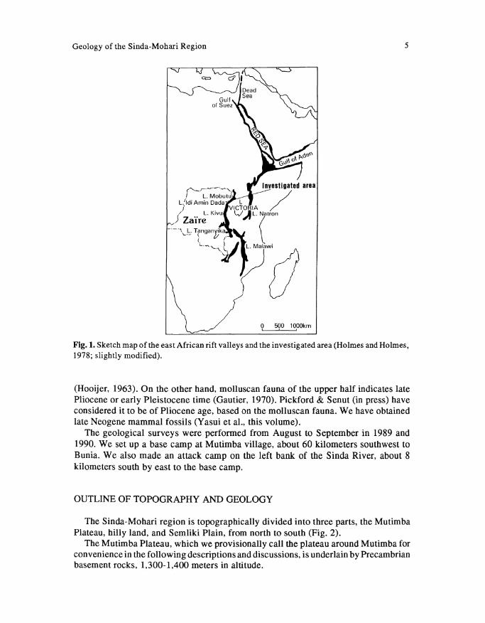
The East African Rift System is one of the topographic and geologic features in the African continent and shows an early phase of separation of the eastern block from the continent. The Rift System is divided into two parts, the Eastern and Western Rifts, and is formed by huge graben zones limited by normal faults from Ethiopia to Mozanbique. The graben is called the rift valley (Fig. 1).
It is also well-known that sediments in and around the rift valleys, especially in the Eastern Rift, yield hominoid fossils. The purpose of our research in eastern Zaire, in cooperation with Centre de Recherche en Sciences Naturelles (C.R.S.N.), Zaire, is to collect fossils of hominoids, mammals, molluscs, etc., and to analyze their geological age and the evolution of hominoids as well as the palaeoenvironment in the Western Rift.
The Western Rift is composed of a chain of narrow lakes arranged en echelon from Lake Mobutu Sese Seko in the north through Lake Tanganyika in the middle to Lake Nyasa in the south. Between Lakes Mobutu and Rutanzige (Edward), Mt. Ruwenzori soars to form an enormous horst block composed of Precambrian rocks. Lake Tanganyika is the deepest, with its bottom below sea level.
The investigated area is a hilly land of the Sinda-Mohari region, Haut-Zaire Province, which is located on the western escarpment of the Western Rift (Fig. 1). Based on the fossils obtained, the strata which form the hilly land were studied stratigraphically by Leriche (1938), Lepersonne (1949), Hopwood & Lepersonne (1953), de Heinzelin (1955), Adam (1959), Hooijer (1963), Gautier (1970), Hooijer (1970), Lepersonne (1970), Pickford & Senut (in press), etc.
The mammal fauna of the lower half in these strata indicates early Miocene in age
Geology of the Sinda-Mohari Region 5
0 500 1000km
Fig.l. Sketch map of the east African rift valleys and the investigated area (Holmes and Holmes, 1978; slightly modified).
(Hooijer, 1963). On the other hand, molluscan fauna of the upper half indicates late Pliocene or early Pleistocene time (Gautier, 1970). Pickford & Senut (in press) have considered it to be of Pliocene age, based on the molluscan fauna. We have obtained late Neogene mammal fossils (Yasui et al., this volume).
The geological surveys were performed from August to September in 1989 and 1990. We set up a base camp at Mutimba village, about 60 kilometers southwest to Bunia. We also made an attack camp on the left bank of the Sinda River, about 8 kilometers south by east to the base camp.
OUTLINE OF TOPOGRAPHY AND GEOLOGY
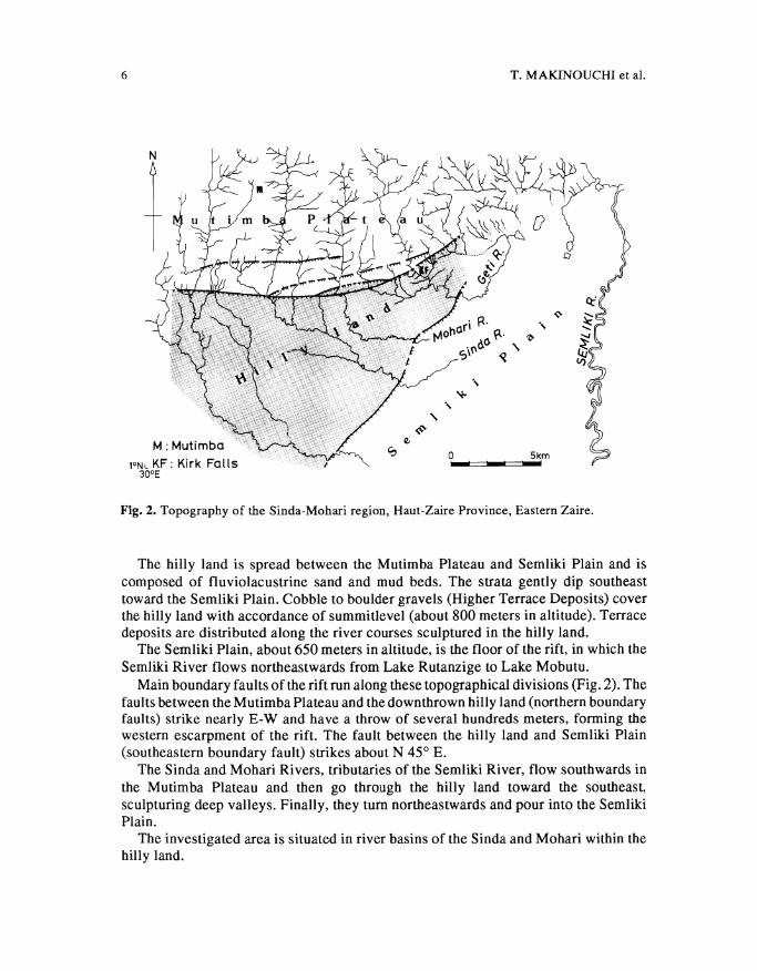
The Sinda-Mobari region is topographically divided into three parts, the Mutimba Plateau, billy land, and Semliki Plain, from north to south (Fig. 2).
The Mutimba Plateau, which we provisionally call the plateau around Mutimba for convenience in the following descriptions and discussions, is underlain by Precambrian basement rocks, 1,300-1,400 meters in altitude.
6
1°NL KF: Kirk Falls 30°E
T. MAKINOUCHI et al.
.,
0 Skm ..... - ........
Fig. 2. Topography of the Sinda-Mohari region, Haut-Zaire Province, Eastern Zaire.
The hilly land is spread between the Mutimba Plateau and Semliki Plain and is composed of fluviolacustrine sand and mud beds. The strata gently dip southeast toward the Semliki Plain. Cobble to boulder gravels (Higher Terrace Deposits) cover the hilly land with accordance of summitlevel (about 800 meters in altitude). Terrace deposits are distributed along the river courses sculptured in the hilly land.
The Semliki Plain, about 650 meters in altitude, is the floor of the rift, in which the Semliki River flows northeastwards from Lake Rutanzige to Lake Mobutu.
Main boundary faults of the rift run along these topographical divisions (Fig. 2). The faults between the Mutimba Plateau and the down thrown hilly land (northern boundary faults) strike nearly E-W and have a throw of several hundreds meters, forming the western escarpment of the rift. The fault between the hilly land and Semliki Plain (southeastern boundary fault) strikes about N 45° E.
The Sinda and Mohari Rivers, tributaries of the Semliki River, flow southwards in the Mutimba Plateau and then go through the hilly land toward the southeast, sculpturing deep valleys. Finally, they tum northeastwards and pour into the Semliki Plain.
The investigated area is situated in river basins of the Sinda and Mohari within the hilly land.
0 C1>
N 0 0
0 Alluvium ~Lower Terrace Deposits ~Middle Terrace Deposits (JQ
'< 0
~ Higher Terrace Deposits ~ Upper Member (Sinda Beds) ...... ;. C1>
• MiddleMember(SindaBeds) [ill OngolibaHorizon(l..ow.M.,SindaBeds)
Cll a· ~
Q Edo Joh Horizon (Lower Member of the Sinda Beds) I>'
~ 0 t:r
~-:;l:l C1>
(JQ
s· ~
/Fault
~ Folding axis
~ Strike & Dip "' Apparent dip •l-IB aM: Fossil Site ;
,/ Footpath EJ: Edo Joh on : Ongoliba AC: Camp 0 lkm
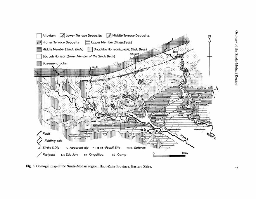
Fig. 3. Geologic map of the Sinda-Mohari region, Haut-Zaire Province, Eastern Zaire.
8 T. MAKINOUCHI et al.
LITHOSTRATIGRAPHY
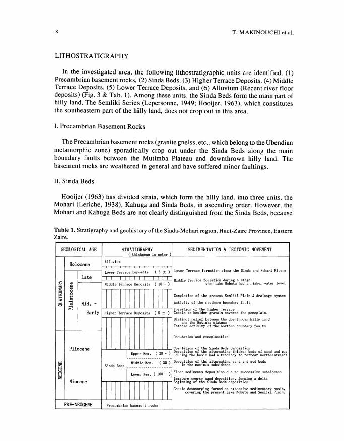
In the investigated area, the following lithostratigraphic units are identified. (1) Precambrian basement rocks, (2) Sinda Beds, (3) Higher Terrace Deposits, ( 4) Middle Terrace Deposits, (5) Lower Terrace Deposits, and (6) Alluvium (Recent river floor deposits) (Fig. 3 & Tab. 1). Among these units, the Sinda Beds form the main part of hilly land. The Semliki Series (Lepersonne, 1949; Hooijer, 1963), which constitutes the southeastern part of the hilly land, does not crop out in this area.
I. Precambrian Basement Rocks
The Precambrian basement rocks (granite gneiss, etc., which belong to the Ubendian metamorphic zone) sporadically crop out under the Sinda Beds along the main boundary faults between the Mutimba Plateau and downthrown hilly land. The basement rocks are weathered in general and have suffered minor faultings.
II. S inda Beds
Hooijer (1963) has divided strata, which form the hilly land, into three units, the Mohari (Leriche, 1938), Kahuga and Sinda Beds, in ascending order. However, the Mohari and Kahuga Beds are not clearly distinguished from the Sinda Beds, because
Table 1. Stratigraphy and geohistory of the Sinda-Mohari region, Haut-Zaire Province, Eastern Zaire.
GEOLOGICAL AGE STRATIGRAPHY SEDIMENTATION & TECTONIC MOVEMENT ( thickness in meter )
Holocene Alluvium
Lower Terrace Deposits ( 5 ± ) Lower Terrace for11ation along the Sinda and Hohari Rivers
Late Middle Terrace formation during a stage >< Ql Middle Terrace Deposits ( 10 - ) when Lake Mobutu had a higher 'orlater level c::
< c: z Ql c:: (J
II LLl 0 Completion of the present Semliki Plain & drainage system ..... ..., < "' :::::> ..... Mid. - Activity of the southern boundary fault 0 Ql .....
0.. Formation of the Higher Terrace Early Higher Terrace Deposits ( 5 ± ) Cobble to boulder gravals covered the peneplain.
Distinct relief between the downthrown hilly land and the Hutimba plateau
Intense activity of the northen boundary faults
Denudation and peneplanation
Pliocene ~~~!JH~~ ~i ~~: ~{~~~n:~1~g d~hi~~!~0beds of sand and mud Upper Hem. ( 20 + ) during the basin had a tendency to retreat northeastwards -----------------------
LLl Middle Hem. ( 30 ) Deposition of the alternating sand and mud beds z Sinda Beds in the maximum subsidence LLl ------------------------
"' Finer sediments deposition due to successive subsidence 0 Lower Hem. ( 100 + ) LLl z ~::i~~i~g c~r~he Si~d~e~~!t~~~~sl~i~~ng a delta Miocene
ll Gentle downwarping formed an e,;tensive sedimentary basin, covering the present Lake Mobutu and Semliki Plain.
PRE-NEOGENE Precambrian basement rocks
Geology of the Sinda-Mohari Region
WestOngollba
I Edo Joh
Site 1
Site 10 Site 8
83006 ~ ~
Site 15 I
Kahuga
Site15 i 15,18
13,14,16 -
17 7
II --------- --- ------------ ---- -- ~~ -------a
-~ " o Ongollba
.c::
m
3 0 I
EdoJoh
8270* 5
6
10 ~!!IWa 4,5,9,12 --------------
-'
Clay, Silt & Fine sand
Alternating sand and mud beds
Medium to coarse sand
Clayey white coarse sand
Gravel
J 1 -18 Fossil horizon of the Site
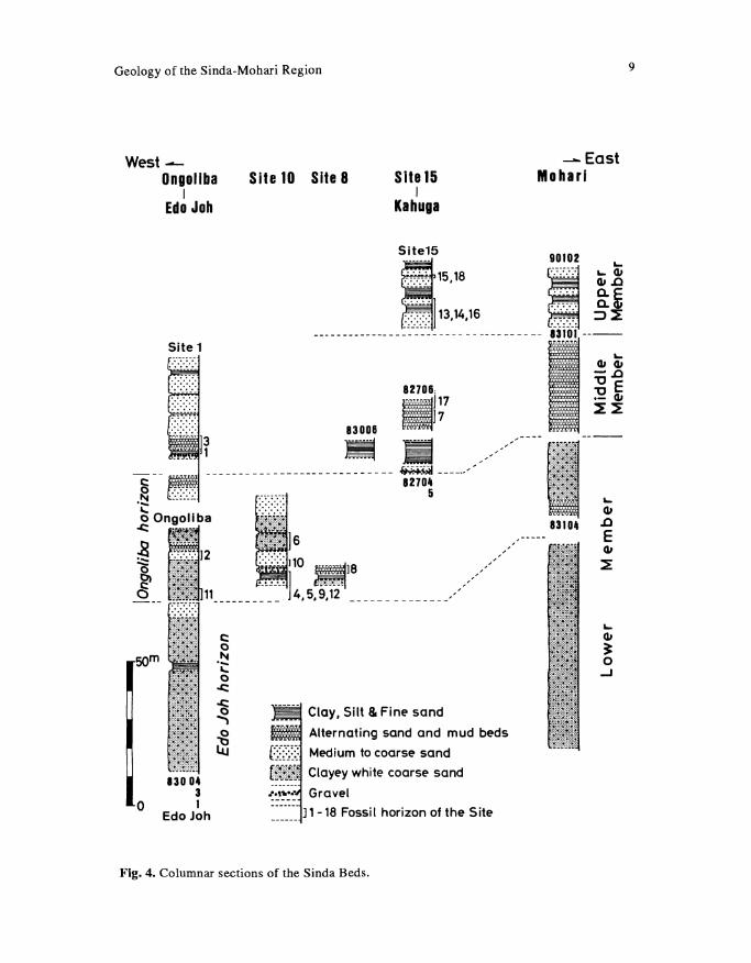
Fig. 4. Columnar sections of the Sinda Beds.
-East Moharl
... 41 ~ 0 ..J
9
10 T. MAKINOUCHI et al.
Brown humus
Medium sand, pale yellow vague parallel lamination
i~~~~~~; Medium sand, brown (to reddish brown) distinct parallel lamination
___ Red colored zone
·"··· .... ·-~
Medium sand, brown, massive
Coarse sand with quartz grain clayey, white to pale gray
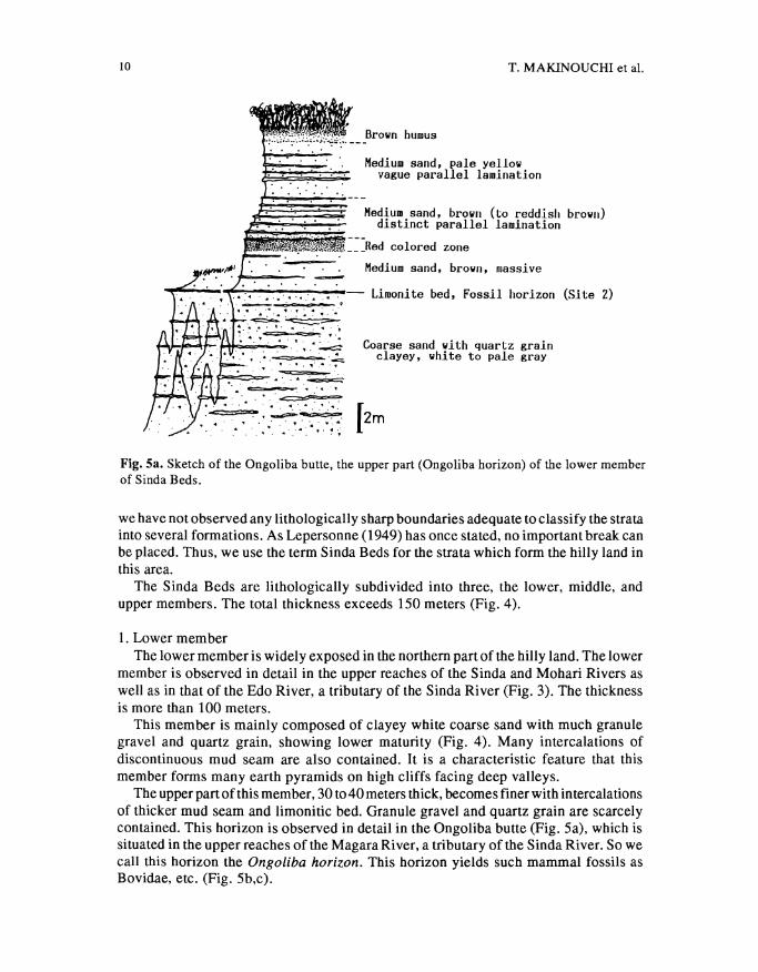
Fig. Sa. Sketch of the Ongoliba butte, the upper part (Ongoliba horizon) of the lower member of Sinda Beds.
we have not observed any lithologically sharp boundaries adequate to classify the strata into several formations. As Lepersonne (1949) bas once stated, no important break can be placed. Thus, we use the term Sinda Beds for the strata which form the billy land in this area.
The Sinda Beds are lithologically subdivided into three, the lower, middle, and upper members. The total thickness exceeds 150 meters (Fig. 4).
1. Lower member The lower member is widely exposed in the northern part of the billy land. The lower
member is observed in detail in the upper reaches of the Sinda and Mobari Rivers as well as in that of the Edo River, a tributary of the Sinda River (Fig. 3). The thickness is more than 100 meters.
This member is mainly composed of clayey white coarse sand with much granule gravel and quartz grain, showing lower maturity (Fig. 4). Many intercalations of discontinuous mud seam are also contained. It is a characteristic feature that this member forms many earth pyramids on high cliffs facing deep valleys.
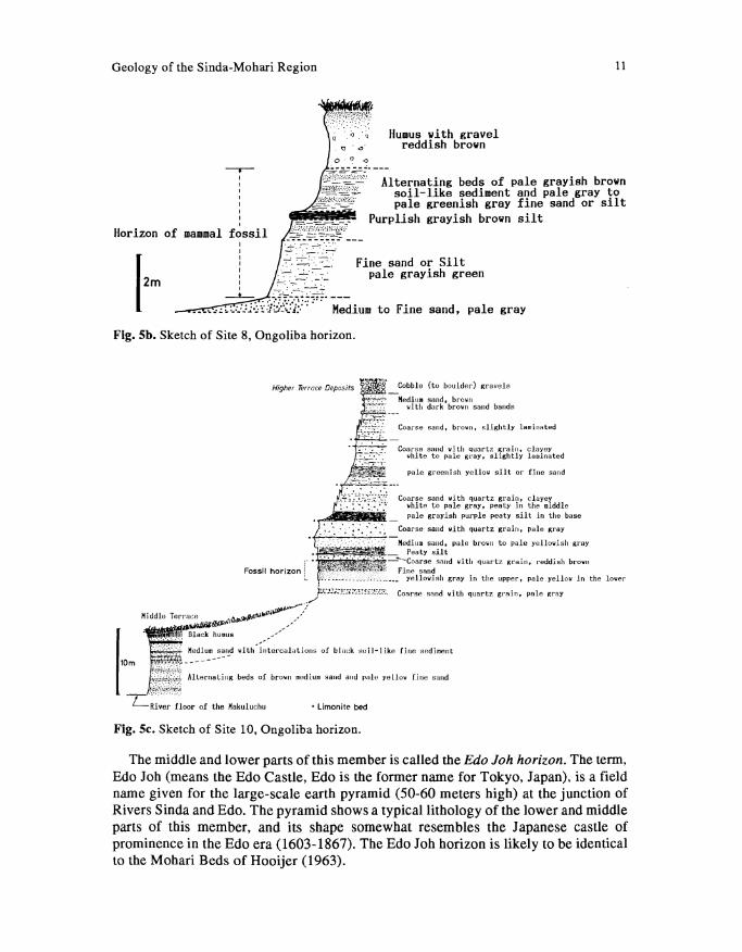
The upper part of this member, 30 to 40 meters thick, becomes finer with intercalations of thicker mud seam and limonitic bed. Granule gravel and quartz grain are scarcely contained. This horizon is observed in detail in the Ongoliba butte (Fig. Sa), which is situated in the upper reaches of the Magara River, a tributary of the Sinda River. So we call this horizon the Ongoliba horizon. This horizon yields such mammal fossils as Bovidae, etc. (Fig. Sb,c).
Geology of the Sinda-Mohari Region
Humus with gravel reddish brown
11
Alternating beds of pale grayish brown soil-like sediment and pale gray to pale greenish gray fine sand or silt
I I I
Purplish grayish brown silt Horizon of mammal fossil
I I I I I I I -·.-·-I . •
_____t.__ _.=-:: ........ ~. ---
Fine sand or Silt pale grayish green
.-!;.:_.~:_:.;:::~1~"::'~~:~:.=·: ,. .. Medium to Fine sand, pale gray
Fig. Sb. Sketch of Site 8, Ongoliba horizon.
Higher Terrace Deposits
Medlu• sand, brown with dark brown sand bands
Coarse sand, brown, slightly laminated
Coarse sand with quartz 'irain, clayey white to pale gray, shghtly laminated
pale greenish yellow silt or fine sand
Coarse sand wl th quartz grain, clayey white to pale gray, peaty in the middle pale grayish purple peaty silt ln the base
Coarse sand with quartz grain, pale ,;ray
·:·;:~:~ Medium sand, pale brown to pale yellowish gray · _ Peaty silt
1 • · • ' ' ·.• .· ·. '' • ---Coarse sand with quartz grain, reddish brown Fossil horizon ! . . Fine sand
L 1 ·~:...:._...;_·.,:·.--~:~~·~;., __ ~--- yellowish gray in the upper, pale yellow in the lower
...-·~J-..;,.;-};;;~;:;.:~u;;;.:,!.:..l.3.;. Coarse sand wit;h quartz gr·ain, pale Rray
Middle Terrace •k-4 ......... ~ ......... ,/ ~,,_,.,... .. - ----
. . . ·.· Nedium ~~r~d with .. i~:ercalatlons of blnek soil-like fine sediment 1 U Black humus _,... ..
lOm iJ:>n:f!,'ll'!;ffl:< Alternating beds of brown medium saud aud pale yellow Line sand ·j(.,,.tl'k:.;~;.;
LRi~er floor of the Makuluchu • Limonite bed
Fig. Sc. Sketch of Site 10, Ongoliba horizon.
The middle and lower parts of this member is called the Edo Joh horizon. The term, Edo Job (means the Edo Castle, Edo is the former name for Tokyo, Japan), is a field name given for the large-scale earth pyramid (50-60 meters high) at the junction of Rivers Sinda and Edo. The pyramid shows a typical lithology of the lower and middle parts of this member, and its shape somewhat resembles the Japanese castle of prominence in the Edo era (1603-1867). The Edo Job horizon is likely to be identical to the Mohari Beds of Hooijer (1963).
12
I
T. MAKINOUCHI et al.
Black soil
pale yellowish gray
Fine sand, yellow brown Medium sand, brown, finer
Fine sand, dark brown
Coarse sand with quartz grain Horizon of reptile and molluscan fossils ~~~~ Alternating beds of
~ pale blue silt and brown coarse sand with quartz grain
brown
Medium sand, brown, loose
~f·.cc~-·-c
17m cannot be observed
''1' • .,./_-- _ _l_--- ---,L.J.UtJ'\11 f cannot be observed
-- - - - - - - i. - --- --
Black soil with gravel Brown medium sand with gravel
Alternating beds of brown medium sand and black soil-like fine sediment
• Limonite bed
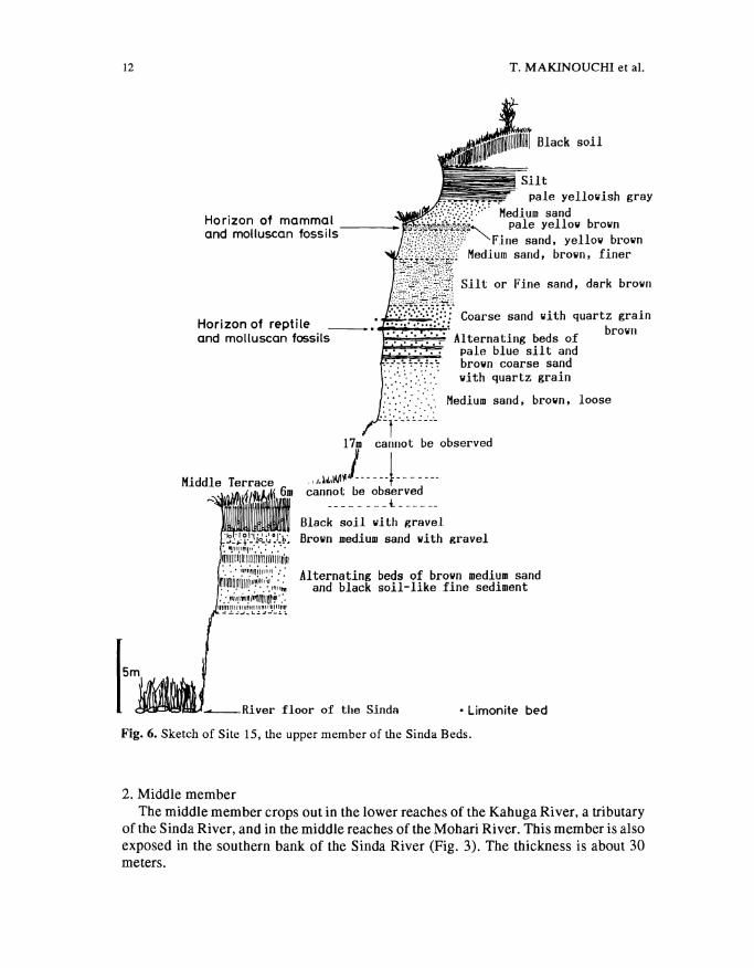
Fig. 6. Sketch of Site 15, the upper member of the Sinda Beds.
2. Middle member The middle member crops out in the lower reaches of the Kahuga River, a tributary
of the Sinda River, and in the middle reaches of the Mohari River. This member is also exposed in the southern bank of the Sinda River (Fig. 3). The thickness is about 30 meters.
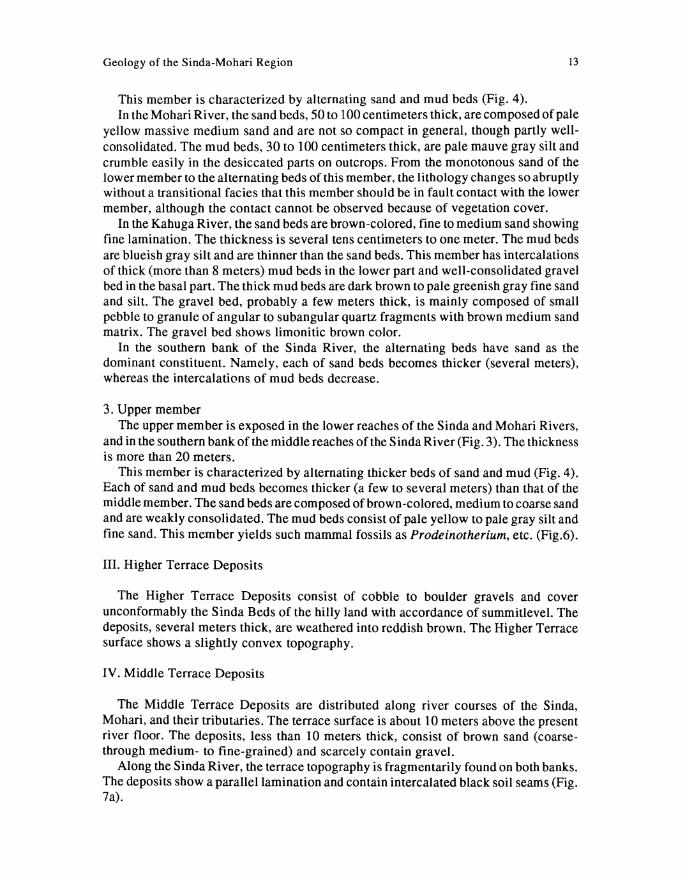
Geology of the Sinda-Mohari Region 13
This member is characterized by alternating sand and mud beds (Fig. 4). In theMohari River, the sand beds, 50 to 100 centimeters thick, are composed of pale
yellow massive medium sand and are not so compact in general, though partly wellconsolidated. The mud beds, 30 to 100 centimeters thick, are pale mauve gray silt and crumble easily in the desiccated parts on outcrops. From the monotonous sand of the lower member to the alternating beds of this member, the lithology changes so abruptly without a transitional facies that this member should be in fault contact with the lower member, although the contact cannot be observed because of vegetation cover.
In the Kahuga River, the sand beds are brown-colored, fine to medium sand showing fine lamination. The thickness is several tens centimeters to one meter. The mud beds are blueish gray silt and are thinner than the sand beds. This member has intercalations of thick (more than 8 meters) mud beds in the lower part and well-consolidated gravel bed in the basal part. The thick mud beds are dark brown to pale greenish gray fine sand and silt. The gravel bed, probably a few meters thick, is mainly composed of small pebble to granule of angular to subangular quartz fragments with brown medium sand matrix. The gravel bed shows limonitic brown color.
In the southern bank of the Sinda River, the alternating beds have sand as the dominant constituent. Namely, each of sand beds becomes thicker (several meters), whereas the intercalations of mud beds decrease.
3. Upper member The upper member is exposed in the lower reaches of the Sinda and Mohari Rivers,
and in the southern bank of the middle reaches ofthe Sinda River (Fig. 3). The thickness is more than 20 meters.
This member is characterized by alternating thicker beds of sand and mud (Fig. 4). Each of sand and mud beds becomes thicker (a few to several meters) than that of the middle member. The sand beds are composed of brown-colored, medium to coarse sand and are weakly consolidated. The mud beds consist of pale yellow to pale gray silt and fine sand. This member yields such mammal fossils as Prodeinotherium, etc. (Fig.6).
III. Higher Terrace Deposits
The Higher Terrace Deposits consist of cobble to boulder gravels and cover unconformably the Sinda Beds of the hilly land with accordance of summitlevel. The deposits, several meters thick, are weathered into reddish brown. The Higher Terrace surface shows a slightly convex topography.
IV. Middle Terrace Deposits
The Middle Terrace Deposits are distributed along river courses of the Sinda, Mohari, and their tributaries. The terrace surface is about 10 meters above the present river floor. The deposits, less than 10 meters thick, consist of brown sand (coarsethrough medium- to fine-grained) and scarcely contain gravel.
Along the Sinda River, the terrace topography is fragmentarily found on both banks. The deposits show a parallel lamination and contain intercalated black soil seams (Fig. 7a).
14 T. MAKINOUCHI et al.
Pale brown coarse sand with pebble partly cross lamination
Fig. 7a. Sketch of an outcrop (83006) of the Middle Terrace Deposits.
Pale greenish gray fine sand with quartz grain coarse sand beds
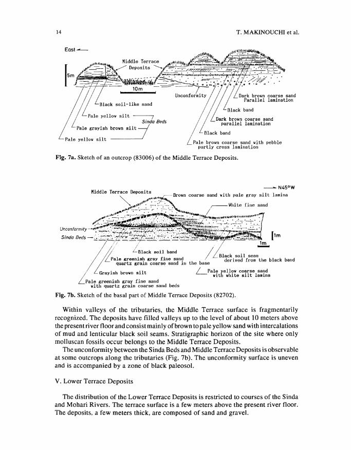
Fig. 7b. Sketch of the basal part of Middle Terrace Deposits (82702).
Within valleys of the tributaries, the Middle Terrace surface is fragmentarily recognized. The deposits have filled valleys up to the level of about 10 meters above the present river floor and consist mainly of brown to pale yellow sand with intercalations of mud and lenticular black soil seams. Stratigraphic horizon of the site where only molluscan fossils occur belongs to the Middle Terrace Deposits.
The unconformity between the Sinda Beds and Middle Terrace Deposits is observable at some outcrops along the tributaries (Fig. 7b). The unconformity surface is uneven and is accompanied by a zone of black paleosol.
V. Lower Terrace Deposits
The distribution of the Lower Terrace Deposits is restricted to courses of the Sinda and Mohari Rivers. The terrace surface is a few meters above the present river floor. The deposits, a few meters thick, are composed of sand and gravel.
Geology of the Sinda-Mohari Region 15
Pale yellowish brown coarse sand Lower Terrace Deposits, cobble
+ + + + ' ! ,, .. ,~1:,~'!"'',. + + + + + •'+
++++++:,4+++
0 20m
+ + + + + + + i + + + / ,+
Fau~~ --- -z~~~~~~ -r~~k- ~~~.~~~,;:;·/0---- _._. "- --sand with granule to ••all pebble /~Pebble to Cobble
grayish yellow / pale grayish yellow
L Unconformity
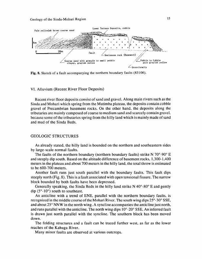
Fig. 8. Sketch of a fault accompanying the northern boundary faults (831 06).
VI. Alluvium (Recent River Floor Deposits)
Recent river floor deposits consist of sand and gravel. Along main rivers such as the Sinda and Mohari which spring from the Mutimba plateau, the deposits contain cobble gravel of Precambrian basement rocks. On the other hand, the deposits along the tributaries are mainly composed of coarse to medium sand and scarcely contain gravel, because some of the tributaries spring from the hilly land which is mainly made of sand and mud of the Sinda Beds.
GEOLOGIC STRUCTURES
As already stated, the hilly land is bounded on the northern and southeastern sides by large-scale normal faults.
The faults of the northern boundary (northern boundary faults) strike N 70°-90° E and steeply dip south. Based on the altitude difference of basement rocks, 1,300-1,400 meters in the plateau and about 700 meters in the hilly land, the total throw is estimated to be 600-700 meters.
Another fault runs just south parallel with the boundary faults. This fault dips steeply north (Fig. 8). This is a fault associated with open tensional fissure. The narrow block bounded by both faults have been depressed.
Generally speaking, the Sinda Beds in the hilly land strike N 40°-80° E and gently dip (5° -10°) south to southeast.
An anticline with a trend of ENE, parallel with the northern boundary faults, is recognized in the middle course of the Mohari River. The south wing dips 25°-30° SSE, and about 25° NNW in the north wing. A syncline accompanies the anticline just north, and runs parallel with the anticline. The north wing dips 10°-20° SSE. An inferred fault is drawn just north parallel with the syncline. The southern block has been moved down.
The folding structures and a fault can be traced further west, as far as the lower reaches of the Kahuga River.
Many minor faults are observed at various outcrops.
16 T. MAKINOUCHI eta!.
DISCUSSION
I. Stratigraphic Horizon of a Few Remarkable Beds
In the Kahuga River, well-consolidated gravel bed is interbedded at the base of the middle member of Sinda Beds. Although it may be due to limonite formation, the lithification of this bed has been considerably advanced in comparison with that of sediments above and below this horizon (Sediments below this bed are not observable in this site). Accordingly, this bed appears to be older than any other bed. It is also noteworthy that most of the gravel are fragments of durable quartz, and less durable gravel, such as Precambrian gneissose rock, is scarcely included. There is a possibility that this bed is of older sediments made of reworked gravel.
In the Mohari River, the middle member of the Sinda Beds, comprised of alternating sand and mud beds, slightly differs from the other members of the Sinda River basin in lithofacies. The accurate horizon of this member should be further examined.
II. Geological Age
Except for the collected fossils, we have no effective data for geological age dating. Dating with the mammal fauna is discussed by Yasui et al., in this volume. Our goal here is to infer the geological ages from the mode of deposition, relative grade of compaction, and so on.
The Lower Terrace Deposits are inferred to be of Holocene or late Pleistocene age from the relative height of the terrace surface being a few meters above the present river floor.
The Middle Terrace Deposits are distributed within valleys of the tributaries and consist of such finer sediments as sand and mud. Accordingly, they date later than the completion of the present drainage system and coincide with the stage when Lake Mobutu had a higher water level. Stages of higher lake level of the Mobutu have been known to be at 28,000-25,000 B.P. and 12,500 B.P. to the present (Harvey, 1976). However, the deposits seem to be slightly older than the former stage from the viewpoint of the grade of compaction. We regard their geologic age as to be early stage of Late Pleistocene age or late stage of Middle Pleistocene age. The R webishengo Beds (Pickford et al., 1989), which exist on the opposite side of the Semliki Plain (Uganda side) and have filled valleys, are similar to the deposits in mode of deposition.
The lithology of the Higher Terrace Deposits shows that there existed a distinct topographic relief in the formational stage between the hinterland (Mutimba plateau) and depositional site (downthrown hilly land). The formational stage corresponds to the intense activity of the northern boundary faults. Compiling previous works, Ebinger (1989) has stated that the uplift along the northeastern flanks of this rift system changed the drainage patterns of several rivers during late Pliocene or Pleistocene time. Thus, the intense activity of the northern boundary faults is considered to be of early to middle Pleistocene age, and also the age of Higher Terrace Deposits.
A consensus has not been reached yet on the age determination of the Sinda Beds with faunal remains. Hooijer (1963) has considered it to be of early Miocene age based on the mammalian fauna, while Pickford & Senut (in press) have judged it to be of Pliocene age based on the molluscan fauna. In view of the grade of compaction, we estimate the age to be younger than early Miocene time.
Geology of the Sinda-Mohari Region 17
Ill. Geohistory
We present a geohistory of this area as a compilation of our research (Tab. 1). In late Neogene time, an extensive sedimentary basin, covering the present Lake
Mobutu and Semliki Plain, was formed by gentle downwarping. In this area, situated in the southwestern marginal zone of the sedimentary basin, deposition of immature coarse sand (Edo Job horizon of the Sinda Beds) took place, forming a delta. This area submerged due to successive subsidence of the basin, and the finer sediments (Ongoliba horizon of the Sinda Beds) were also deposited. Thereafter, this area reached the maximum subsidence, and the alternating sand and mud beds (middle member of the Sinda Beds) were formed. Finally, the basin had a tendency to retreat from this area toward the center, and the upper member of the Sinda Beds was deposited. Thus, the basin completed the deposition of Sinda Beds in this area.
Thereafter, long-term denudation and peneplanation prevailed in this area. In early to middle Pleistocene time, the intense activity of the northern boundary
faults formed the distinct relief between the down thrown hilly land and the Mutimba plateau, as already discussed, and then cobble to boulder gravel of the Higher Terrace Deposits were supplied on the peneplain.
Activity of the southeastern boundary fault, which runs between the hilly land and Semliki Plain, is considered to date later than that of the northern boundary faults. The present Semliki Plain was made clear its outline as the floor of rift valley by the activity of the southeastern boundary fault.
Formation of the present Semliki Plain has confirmed the present drainage system, and then the deep valleys have been sculptured in and around the hilly land.
During late Quaternary time, the Middle Terrace Deposits were formed within the deep valleys.
ACKNOWLEDGMENTS We would like to thank Dr. N. ZANA, General Director of Centre de Recherche en Sciences Naturelles (C.R.S.N.), Zaire, for supporting our research and the Japanese Ministry of Education, Science and Culture for financial support. We wish to express our sincere thanks Dr. K. Yasui of Dokkyo University School of Medicine, Mr. M. Nakatsukasa of Osaka Medical College, Mr. Y. Kunimatsu of Kyoto University, and people of Mutimba who supported our field work. We wish to thank Dr. M. Pickford of Institut de Paleontologie, Paris for his suggestions on sediments in the Western Rift.
REFERENCES
Adam, W. 1959. Mollusques pleistocenes de la region dulac Albert et de la Semliki. Annales du Musee royal du Congo beige, in-8°, Sciences Geologiques, 25, XV+ 149p.
de Heinzelin, J. 1955. Le fosse tectonique so us le paralleled' Ishango.lnstitut de Pares national de Congo beige, Exploration du Pare national de Albert, Mission J. De Heinzelin de Braucourt (1950), fascicule 1, 150p.
Ebinger, C. J. 1989. Tectonic development of the western branch of the East African rift system. Geological Society of America Bulletin, 101: 885-903.
18 T. MAKIN OUCH! et al.
Gautier, A. 1970. Fossil fresh water mollusca of the Lake Albert-Lake Edward rift. Annales du Musee royal de l'Afrique Centrale, 67: 1-144.
Harvey, T. J. 1976. The paleolimnology of Lake Mobutu Sese Seko, Uganda -Zaire: the last 28,000 years. Ph.D. thesis, Duke University, North Carolina, 113p.
Holmes, A. &D.L. Holmes 1978. Holmes Principles of Physical Geology. VanNostland Reinhold, Wokingham, England, 730p.
Hooijer, D. A. 1963. Miocene Mammalia of Congo. Annales du Musee royal de l'Afrique Centrale, in-8, Sciences Geologiques, 46: 1-77.
Hooijer, D. A. 1970. Miocene Mammalia of Congo, a correction. Annales du Musee royal de l'Afrique Centrale, 67: 161-167.
Hopwood, A. T. & J. LEPERSONNE 1953. Presence de formations d'age miocene infereur dans le fosse tectonique du Lac Albert et de la Basse Semliki (Congo belge). Annales de La Societe Geologique de Belgique, 77: B83-113.
Lepersonne, J. 1949. Le fosse tectonique Lac Albert-Semliki-Lac Edouard. Resume des observations geologiques effectuees en 1938-1939-1940.Annales de La Societe Geologique de Belgique, 77: M1-92.
Lepersonne, J. 1970. Revision of the fauna and the stratigraphy of the fossilferous localities of the Lake Albert-Lake Edward rift (Congo). Annales du Musee royal de l'Afrique Centrale, 67: 169-207.
Leriche, M. 1938. Surles fossles recueillis dans les Kaiso beds (Pleistocene inferieur) de Ia prtie conglolaise de Ia Plaine de la Semliki. Annales de La Societe Geologique de Belgique, 77: Bl18-130.
Pickford, M., B. Senut, H. Roche, P. Mein, G. Ndaati, P. Obwona & J. Tuhumwire 1989. Uganda Paleontology Expedition: results of the second field season (1987) in the Kisegi-Nyabusosi area (Lake Albert Basin, Uganda). Comptes Rendus de l'Academie des Sciences, Paris, 308, Serie II: 1751-1758.
Pickford, M. & B. Senut (in press) Stratigraphy of the Western Rift Valley, UgandaZaire. Comptes Rendus de l'Academie des Sciences, Paris
Yasui, K., Y. Kunimatsu, N. Kuga, B. Bajope, & H. Ishida 1992. Fossil mammals from the Neogene strata in the Sinda basin, eastern Zaire. African Study Monographs, Supplementary Issue 17: 87-107.
---Received December 20, 1991
Authors' Names and Addresses: Takeshi MAKINOUCHI, Department of Earth Science, Meijo University, Tempaku-ku, Nagoya 468, Japan*; Shiro ISHIDA, Department of Geology and Mineralogy, Yamaguchi University, Yamaguchi 753, Japan; Yoshihiro SAWADA & Yuji ORIHASHI, Department of Geology, Shimane University, Matsue 690, Japan; NaoyukiKUGA & Nobukazu KIMURA, DepartmentofGeologyandMineralogy, Kyoto University, Sakyo-ku, Kyoto 606, Japan; Baluku BAJOPE, Centre de Recherche en Sciences Naturelles ( C.R.S.N.), Lwiro, Bukavu, Kivu, Zai"re; Munyololo wa YEMBA, Centre de Recherches en Geologiques Minieres (C.R.G.M.), Lwiro, Bukavu, Kivu, Zai"re; Hidemi ISHIDA, Laboratory of Physical Anthropology, Kyoto University, Sakyo-ku, Kyoto 606, Japan. *Correspondence and reprint address


![ŠKOLSKI KURIKULUMos-igkovacic-svetijurajnabregu.skole.hr/upload/os... · Sonja Rodinger i Vera Mohari – Izrada sapuna u obliku leptira Alen Barbi , Domagoj Zori ] i Igor Jaušovec](https://img.pdfslide.tips/doc/110x75/5e2f7a592a1b0f005d7f6fe3/kolski-kurikulumos-igkovacic-sonja-rodinger-i-vera-mohari-a-izrada-sapuna-u.jpg)