Embed Size (px)
Citation preview
Editor: Prof. Dr.-Ing. habil. Heinz Konietzky Layout: Angela Griebsch TU Bergakademie Freiberg, Institut für Geotechnik, Gustav-Zeuner-Straße 1, 09599 Freiberg • [email protected]
Geophysical methods for rock engineering – an overview Author: Prof. Dr. habil. Heinz Konietzky (TU Bergakademie Freiberg, Geotechnical Institute)
1 Introduction ............................................................................................................. 2
2 Classification .......................................................................................................... 3
3 Popular methods in rock engineering ..................................................................... 6
3.1 Seismic methods .............................................................................................. 6
3.1.1 Active seismic methods ............................................................................. 6
3.1.2 Passive seismic methods ........................................................................... 7
3.2 Gravimetry ........................................................................................................ 7
3.3 Electric and electromagnetic methods .............................................................. 7
4 Examples: cavity / karst detection .......................................................................... 8
5 Examples: exploration while drilling and tunneling ............................................... 15
6 Examples: landslides / rockfall ............................................................................. 18
7 Examples: borehole measurements ..................................................................... 20
8 Examples: fracture detection via ground penetration radar .................................. 23
9 References ........................................................................................................... 25
Geophysical methods for rock engineering – an overview Only for private and internal use! Updated: 10 March 2021
Page 2 of 26
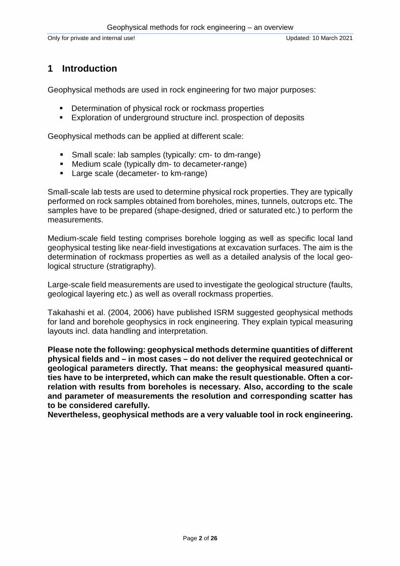
1 Introduction Geophysical methods are used in rock engineering for two major purposes: Determination of physical rock or rockmass properties Exploration of underground structure incl. prospection of deposits
Geophysical methods can be applied at different scale: Small scale: lab samples (typically: cm- to dm-range) Medium scale (typically dm- to decameter-range) Large scale (decameter- to km-range)
Small-scale lab tests are used to determine physical rock properties. They are typically performed on rock samples obtained from boreholes, mines, tunnels, outcrops etc. The samples have to be prepared (shape-designed, dried or saturated etc.) to perform the measurements. Medium-scale field testing comprises borehole logging as well as specific local land geophysical testing like near-field investigations at excavation surfaces. The aim is the determination of rockmass properties as well as a detailed analysis of the local geo-logical structure (stratigraphy). Large-scale field measurements are used to investigate the geological structure (faults, geological layering etc.) as well as overall rockmass properties. Takahashi et al. (2004, 2006) have published ISRM suggested geophysical methods for land and borehole geophysics in rock engineering. They explain typical measuring layouts incl. data handling and interpretation. Please note the following: geophysical methods determine quantities of different physical fields and – in most cases – do not deliver the required geotechnical or geological parameters directly. That means: the geophysical measured quanti-ties have to be interpreted, which can make the result questionable. Often a cor-relation with results from boreholes is necessary. Also, according to the scale and parameter of measurements the resolution and corresponding scatter has to be considered carefully. Nevertheless, geophysical methods are a very valuable tool in rock engineering.
Geophysical methods for rock engineering – an overview Only for private and internal use! Updated: 10 March 2021
Page 3 of 26
2 Classification There are different possibilities to classify geophysical measurements. One possibility is to distinguish between: Active measurements (physical fields are produced artificially) Passive measurements (existing physical fields are used)
Another possibility if to distinguish between the different physical fields under investi-gation:
Seismic methods (wave velocity) Gravimetry (density) Electro-magnetic methods (electrical resistivity / magnetic susceptibility / die-
lectric constant) Radiometric methods (neutron- and γ-radiation)
Also common is to distinguish between the places of installation: Ground-based measuring (at the surface) Borehole logging Combination of ground-based measurements with borehole tools
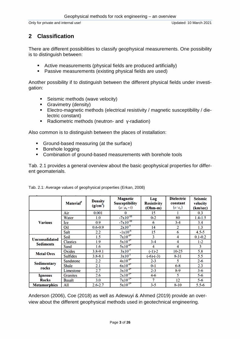
Tab. 2.1 provides a general overview about the basic geophysical properties for differ-ent geomaterials. Tab. 2.1: Average values of geophysical properties (Erkan, 2008)
Anderson (2006), Coe (2018) as well as Adewuyi & Ahmed (2019) provide an over-view about the different geophysical methods used in geotechnical engineering.
Geophysical methods for rock engineering – an overview Only for private and internal use! Updated: 10 March 2021
Page 4 of 26
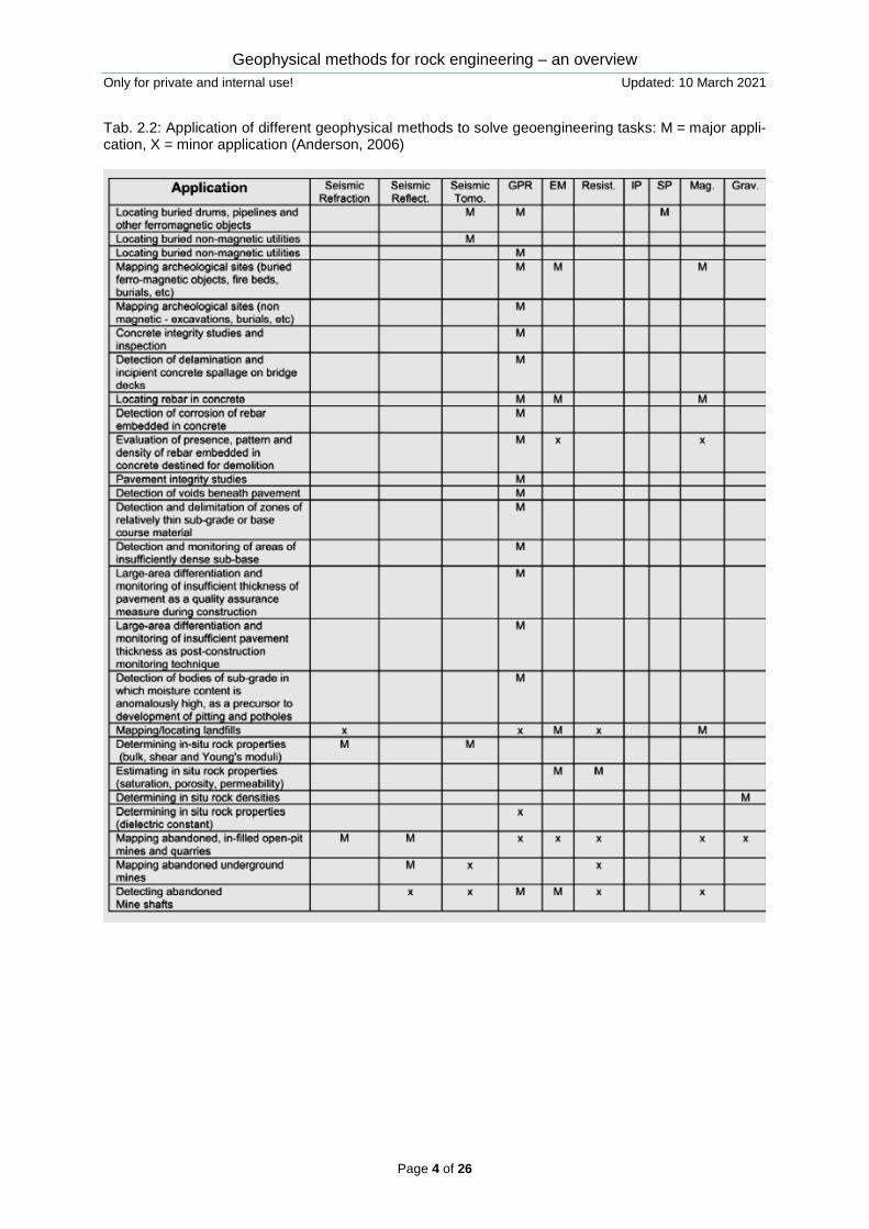
Tab. 2.2: Application of different geophysical methods to solve geoengineering tasks: M = major appli-cation, X = minor application (Anderson, 2006)
Geophysical methods for rock engineering – an overview Only for private and internal use! Updated: 10 March 2021
Page 5 of 26
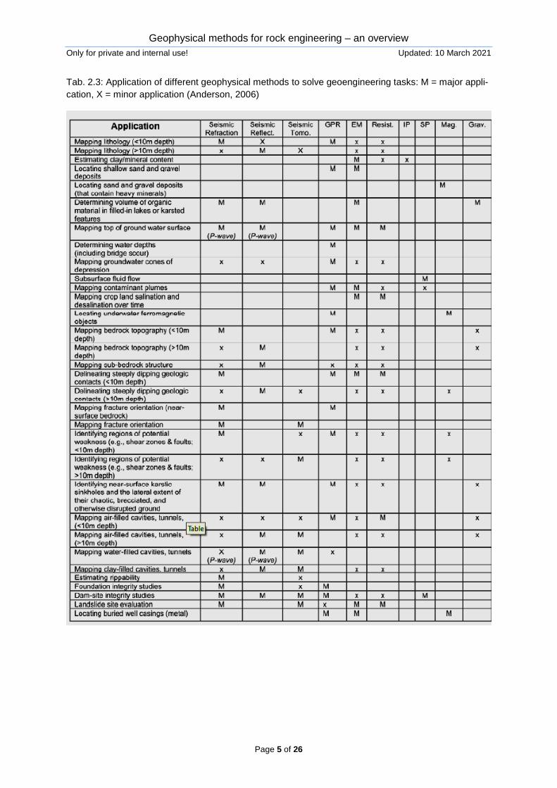
Tab. 2.3: Application of different geophysical methods to solve geoengineering tasks: M = major appli-cation, X = minor application (Anderson, 2006)
Geophysical methods for rock engineering – an overview Only for private and internal use! Updated: 10 March 2021
Page 6 of 26
3 Popular methods in rock engineering
Within this chapter popular methods applied in rock engineering are shortly character-ized. Some selected individual examples are shown in chapters 4 to 7. This chapter does not consider lab-scale methods (see our e-book “Overview about rockmechanical lab testing”), but only in-situ measurements.
3.1 Seismic methods
3.1.1 Active seismic methods
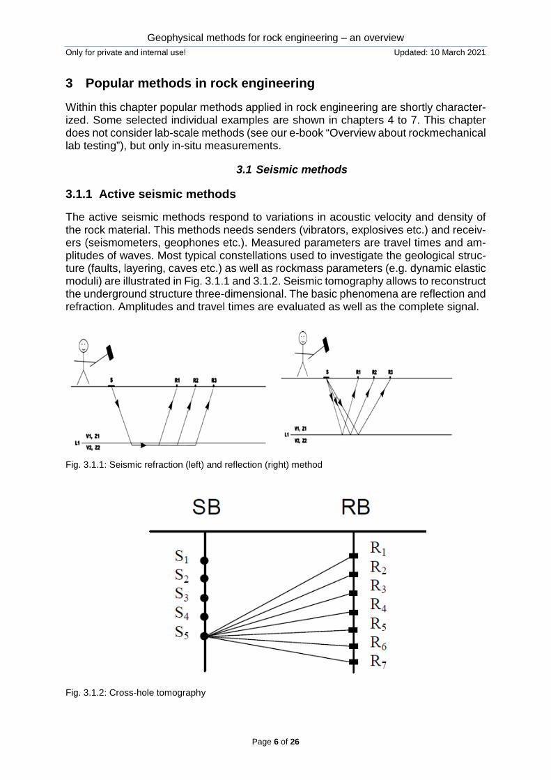
The active seismic methods respond to variations in acoustic velocity and density of the rock material. This methods needs senders (vibrators, explosives etc.) and receiv-ers (seismometers, geophones etc.). Measured parameters are travel times and am-plitudes of waves. Most typical constellations used to investigate the geological struc-ture (faults, layering, caves etc.) as well as rockmass parameters (e.g. dynamic elastic moduli) are illustrated in Fig. 3.1.1 and 3.1.2. Seismic tomography allows to reconstruct the underground structure three-dimensional. The basic phenomena are reflection and refraction. Amplitudes and travel times are evaluated as well as the complete signal.
Fig. 3.1.1: Seismic refraction (left) and reflection (right) method
Fig. 3.1.2: Cross-hole tomography
Geophysical methods for rock engineering – an overview Only for private and internal use! Updated: 10 March 2021
Page 7 of 26
3.1.2 Passive seismic methods
Passive seismic methods are based on observations of seismic waves originated by natural (e.g. earthquakes) or man-made (e.g. rockbursts, blasting, explosions) events. For more details see our e-book “Dynamic events in hard rocks”.
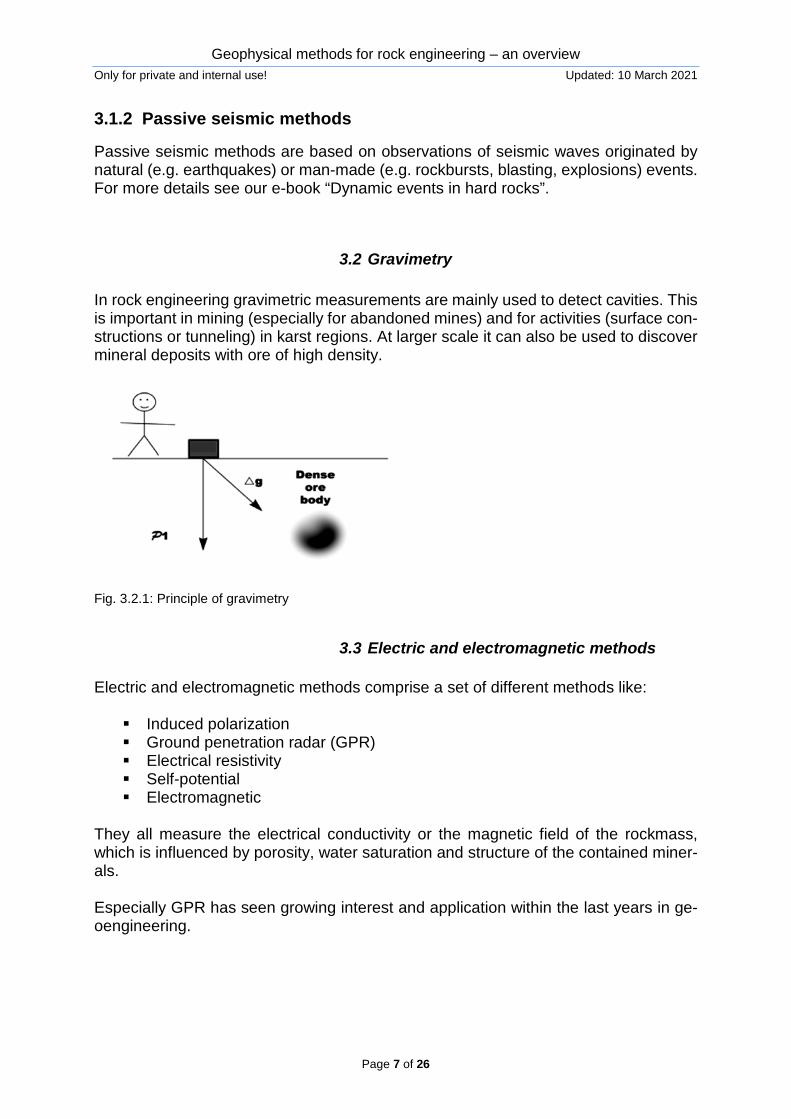
3.2 Gravimetry In rock engineering gravimetric measurements are mainly used to detect cavities. This is important in mining (especially for abandoned mines) and for activities (surface con-structions or tunneling) in karst regions. At larger scale it can also be used to discover mineral deposits with ore of high density.
Fig. 3.2.1: Principle of gravimetry
3.3 Electric and electromagnetic methods Electric and electromagnetic methods comprise a set of different methods like: Induced polarization Ground penetration radar (GPR) Electrical resistivity Self-potential Electromagnetic
They all measure the electrical conductivity or the magnetic field of the rockmass, which is influenced by porosity, water saturation and structure of the contained miner-als. Especially GPR has seen growing interest and application within the last years in ge-oengineering.
Geophysical methods for rock engineering – an overview Only for private and internal use! Updated: 10 March 2021
Page 8 of 26
4 Examples: cavity / karst detection
Geophysical methods are successfully applied for detection of cavities. Typical exam-ples are: detection of karst cavities in respect to tunneling or road/railway construction.
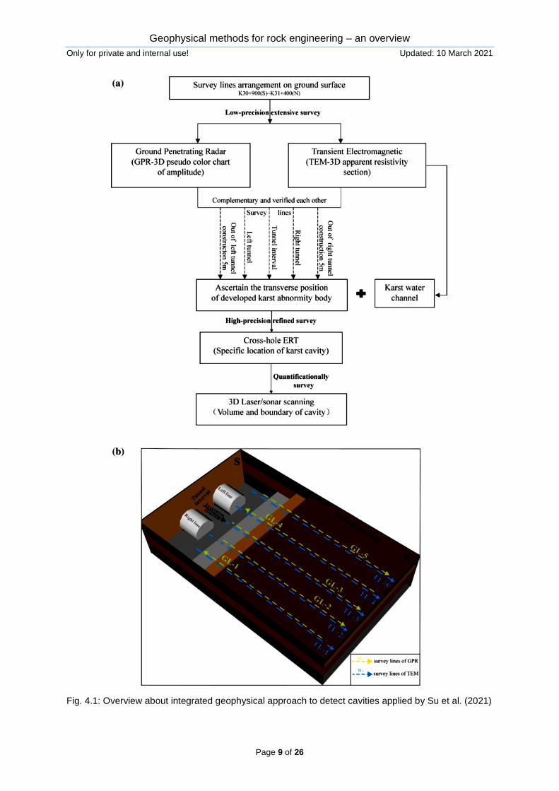
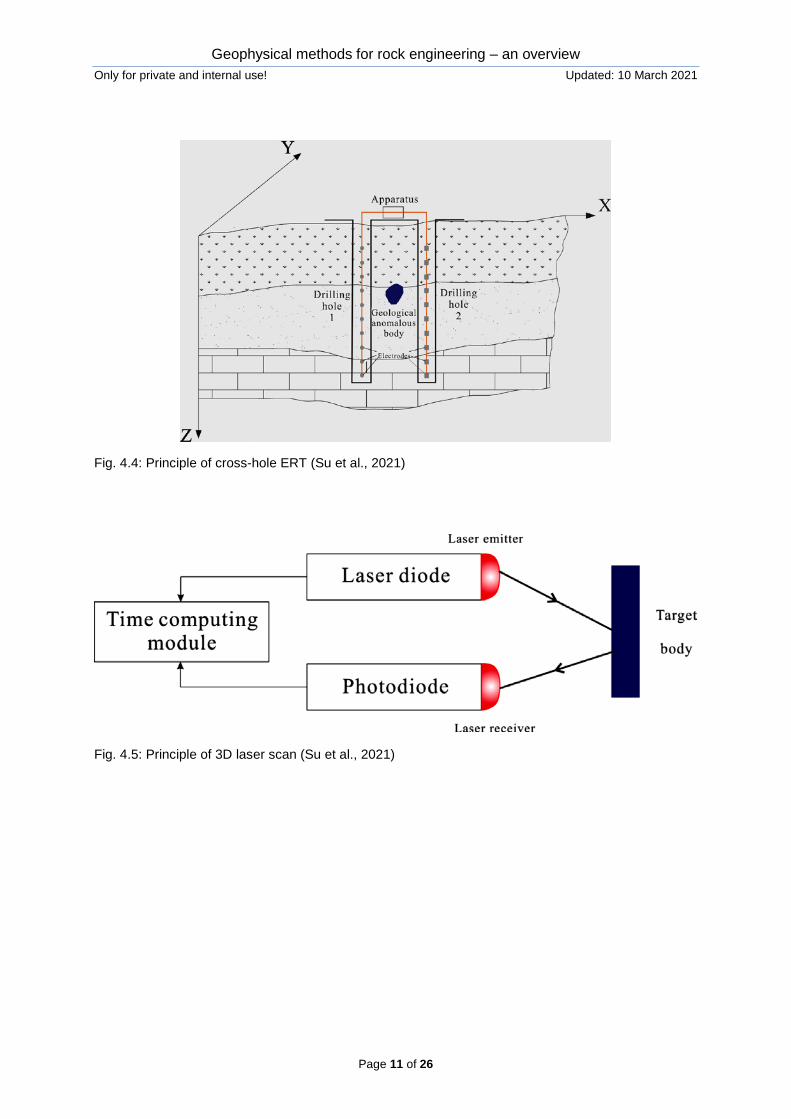
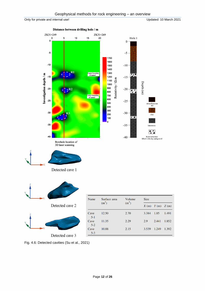
Su et al. (2021) present an integrated geophysical approach comprising ground pene-tration radar (GPR), transient electromagnetics (TEM), cross-hole electrical resistivity tomography (ERT) and 3D laser scanning to detect karst cavities for a subway project (see Fig. 4.1). Figures 4.2 to 4.5 illustrate the principles of the different methods, which were step-by-step applied, beginning with large scale screening via GPR and TEM followed by cross-hole ERT and ending with precise cavity measurement via 3D laser scanning. Fig. 4.6 shows the final result.
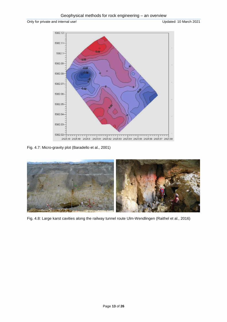
Baradello et al. (2001) also presented an interdisciplinary approach applying gravity method, resistivity method and GPR. Exemplary, Fig. 4.7 shows the result of micro-gravity measurements. The negative anomaly at the left corner indicates a cavity, which was later confirmed by other measuring techniques.
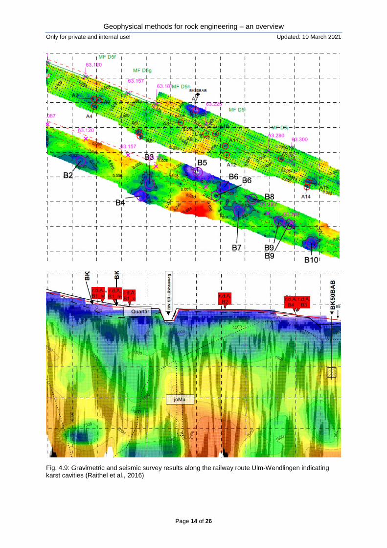
Raithel et al. (2016) show, how geophysical measuring techniques (here: gravimetry and seismic methods) are used to detect large karst cavities along the tunnel route Ulm-Wendlingen (Germany).
Lehmann et al. (2018) describe the application of borehole radar in two different modes: as reflection (RX) mode and cross-hole (CH) mode.
Bacic et al. (2020) documents some examples for karst exploration using seismic methods.
Geophysical methods for rock engineering – an overview Only for private and internal use! Updated: 10 March 2021
Page 9 of 26
Fig. 4.1: Overview about integrated geophysical approach to detect cavities applied by Su et al. (2021)
Geophysical methods for rock engineering – an overview Only for private and internal use! Updated: 10 March 2021
Page 10 of 26
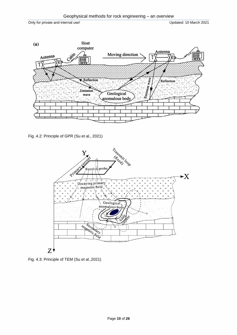
Fig. 4.2: Principle of GPR (Su et al., 2021)
Fig. 4.3: Principle of TEM (Su et al.,2021)
Geophysical methods for rock engineering – an overview Only for private and internal use! Updated: 10 March 2021
Page 11 of 26
Fig. 4.4: Principle of cross-hole ERT (Su et al., 2021)
Fig. 4.5: Principle of 3D laser scan (Su et al., 2021)
Geophysical methods for rock engineering – an overview Only for private and internal use! Updated: 10 March 2021
Page 12 of 26
Fig. 4.6: Detected cavities (Su et al., 2021)
Geophysical methods for rock engineering – an overview Only for private and internal use! Updated: 10 March 2021
Page 13 of 26
Fig. 4.7: Micro-gravity plot (Baradello et al., 2001)
Fig. 4.8: Large karst cavities along the railway tunnel route Ulm-Wendlingen (Raithel et al., 2016)
Geophysical methods for rock engineering – an overview Only for private and internal use! Updated: 10 March 2021
Page 14 of 26
Fig. 4.9: Gravimetric and seismic survey results along the railway route Ulm-Wendlingen indicating karst cavities (Raithel et al., 2016)
Geophysical methods for rock engineering – an overview Only for private and internal use! Updated: 10 March 2021
Page 15 of 26
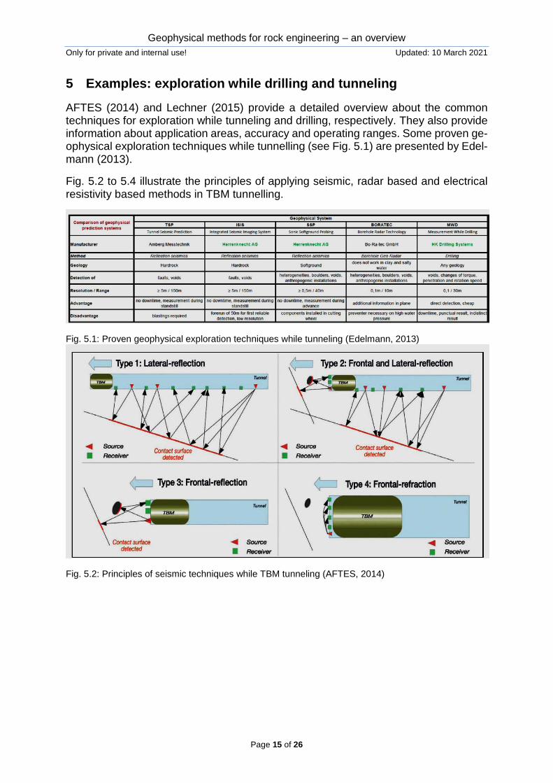
5 Examples: exploration while drilling and tunneling
AFTES (2014) and Lechner (2015) provide a detailed overview about the common techniques for exploration while tunneling and drilling, respectively. They also provide information about application areas, accuracy and operating ranges. Some proven ge-ophysical exploration techniques while tunnelling (see Fig. 5.1) are presented by Edel-mann (2013).
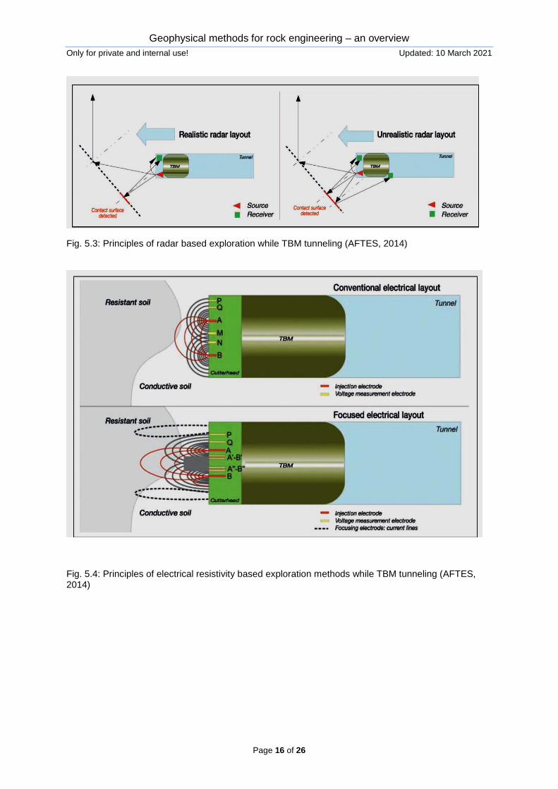
Fig. 5.2 to 5.4 illustrate the principles of applying seismic, radar based and electrical resistivity based methods in TBM tunnelling.
Fig. 5.1: Proven geophysical exploration techniques while tunneling (Edelmann, 2013)
Fig. 5.2: Principles of seismic techniques while TBM tunneling (AFTES, 2014)
Geophysical methods for rock engineering – an overview Only for private and internal use! Updated: 10 March 2021
Page 16 of 26
Fig. 5.3: Principles of radar based exploration while TBM tunneling (AFTES, 2014)
Fig. 5.4: Principles of electrical resistivity based exploration methods while TBM tunneling (AFTES, 2014)
Geophysical methods for rock engineering – an overview Only for private and internal use! Updated: 10 March 2021
Page 17 of 26
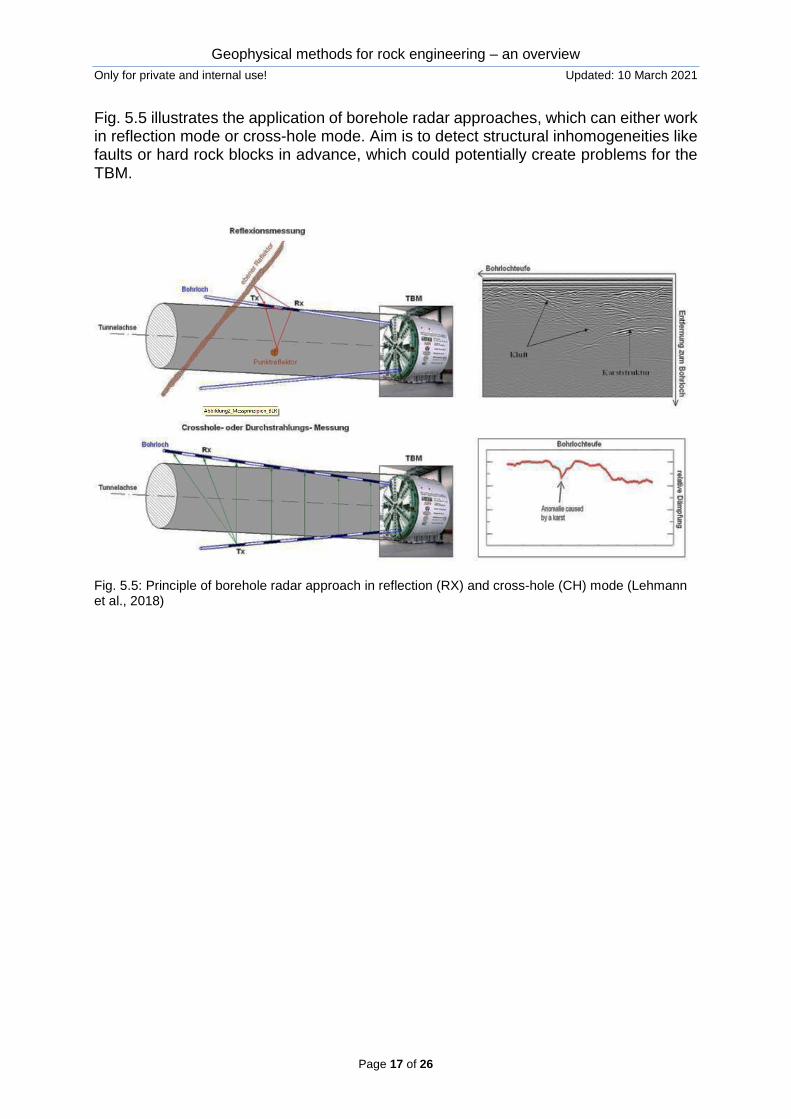
Fig. 5.5 illustrates the application of borehole radar approaches, which can either work in reflection mode or cross-hole mode. Aim is to detect structural inhomogeneities like faults or hard rock blocks in advance, which could potentially create problems for the TBM.
Fig. 5.5: Principle of borehole radar approach in reflection (RX) and cross-hole (CH) mode (Lehmann et al., 2018)
Geophysical methods for rock engineering – an overview Only for private and internal use! Updated: 10 March 2021
Page 18 of 26
6 Examples: landslides / rockfall
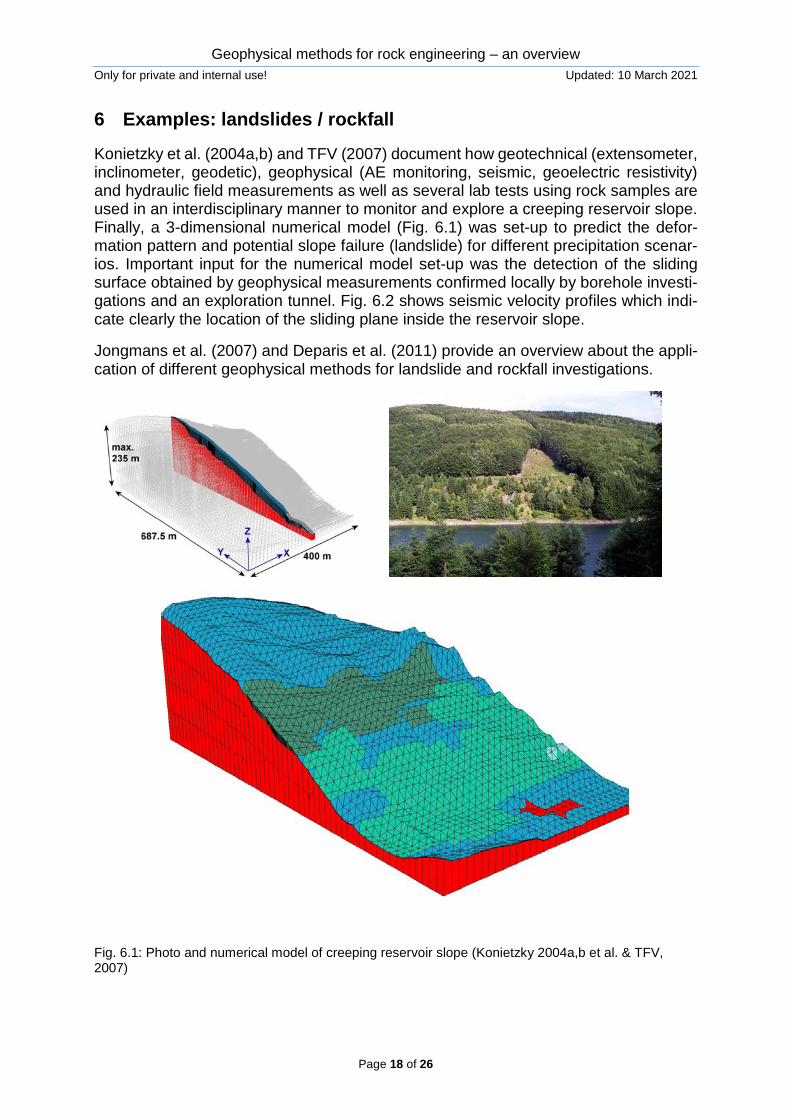
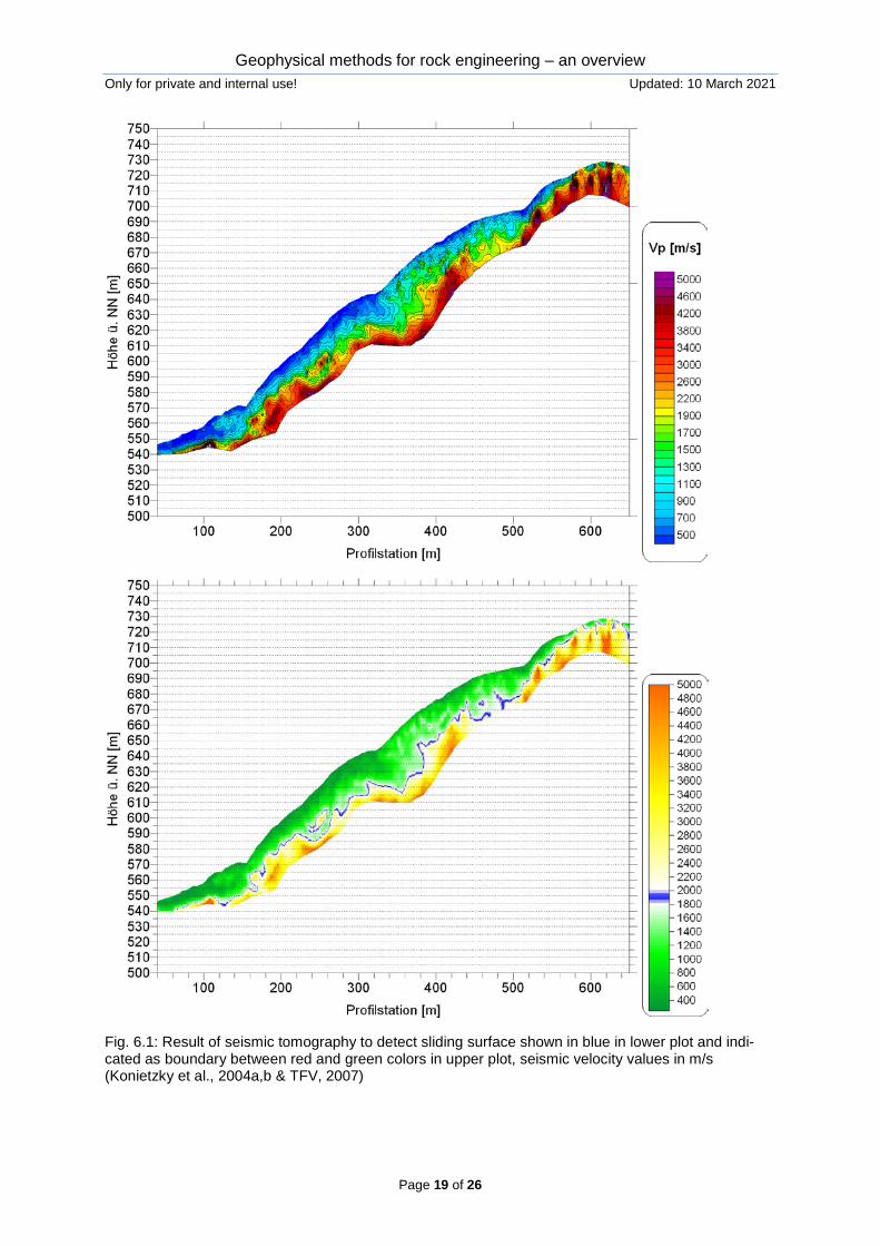
Konietzky et al. (2004a,b) and TFV (2007) document how geotechnical (extensometer, inclinometer, geodetic), geophysical (AE monitoring, seismic, geoelectric resistivity) and hydraulic field measurements as well as several lab tests using rock samples are used in an interdisciplinary manner to monitor and explore a creeping reservoir slope. Finally, a 3-dimensional numerical model (Fig. 6.1) was set-up to predict the defor-mation pattern and potential slope failure (landslide) for different precipitation scenar-ios. Important input for the numerical model set-up was the detection of the sliding surface obtained by geophysical measurements confirmed locally by borehole investi-gations and an exploration tunnel. Fig. 6.2 shows seismic velocity profiles which indi-cate clearly the location of the sliding plane inside the reservoir slope.
Jongmans et al. (2007) and Deparis et al. (2011) provide an overview about the appli-cation of different geophysical methods for landslide and rockfall investigations.
Fig. 6.1: Photo and numerical model of creeping reservoir slope (Konietzky 2004a,b et al. & TFV, 2007)
Geophysical methods for rock engineering – an overview Only for private and internal use! Updated: 10 March 2021
Page 19 of 26
Fig. 6.1: Result of seismic tomography to detect sliding surface shown in blue in lower plot and indi-cated as boundary between red and green colors in upper plot, seismic velocity values in m/s (Konietzky et al., 2004a,b & TFV, 2007)
Geophysical methods for rock engineering – an overview Only for private and internal use! Updated: 10 March 2021
Page 20 of 26
7 Examples: borehole measurements
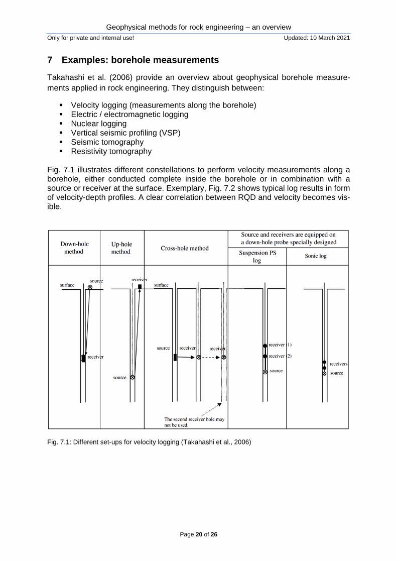
Takahashi et al. (2006) provide an overview about geophysical borehole measure-ments applied in rock engineering. They distinguish between:
Velocity logging (measurements along the borehole) Electric / electromagnetic logging Nuclear logging Vertical seismic profiling (VSP) Seismic tomography Resistivity tomography
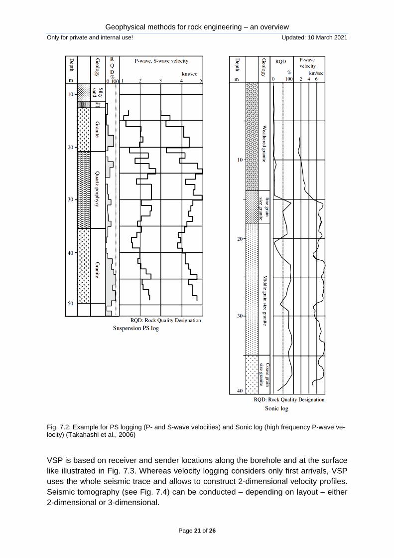
Fig. 7.1 illustrates different constellations to perform velocity measurements along a borehole, either conducted complete inside the borehole or in combination with a source or receiver at the surface. Exemplary, Fig. 7.2 shows typical log results in form of velocity-depth profiles. A clear correlation between RQD and velocity becomes vis-ible.
Fig. 7.1: Different set-ups for velocity logging (Takahashi et al., 2006)
Geophysical methods for rock engineering – an overview Only for private and internal use! Updated: 10 March 2021
Page 21 of 26
Fig. 7.2: Example for PS logging (P- and S-wave velocities) and Sonic log (high frequency P-wave ve-locity) (Takahashi et al., 2006)
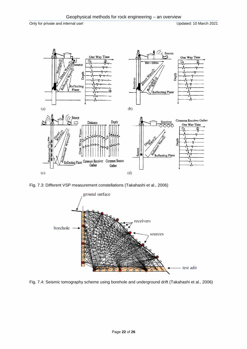
VSP is based on receiver and sender locations along the borehole and at the surface like illustrated in Fig. 7.3. Whereas velocity logging considers only first arrivals, VSP uses the whole seismic trace and allows to construct 2-dimensional velocity profiles. Seismic tomography (see Fig. 7.4) can be conducted – depending on layout – either 2-dimensional or 3-dimensional.
Geophysical methods for rock engineering – an overview Only for private and internal use! Updated: 10 March 2021
Page 22 of 26
Fig. 7.3: Different VSP measurement constellations (Takahashi et al., 2006)
Fig. 7.4: Seismic tomography scheme using borehole and underground drift (Takahashi et al., 2006)
Geophysical methods for rock engineering – an overview Only for private and internal use! Updated: 10 March 2021
Page 23 of 26
8 Examples: fracture detection via ground penetration radar
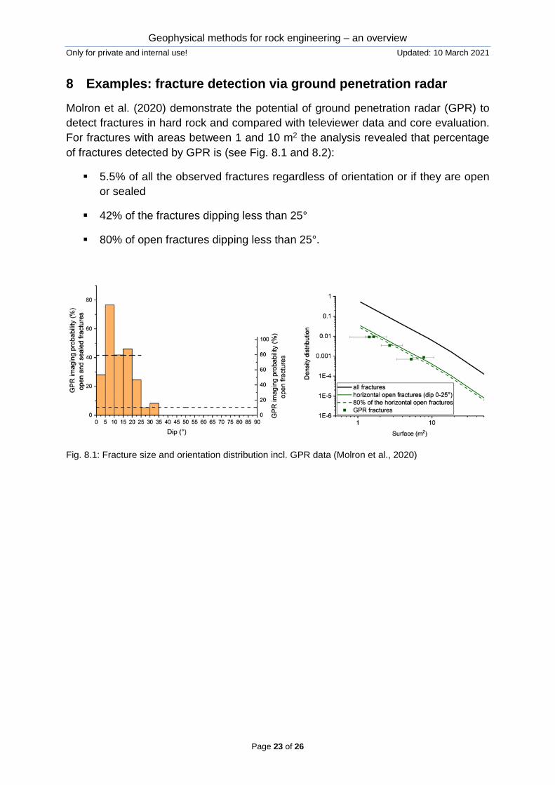
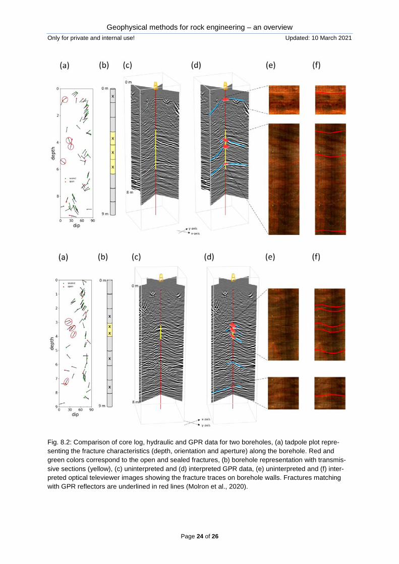
Molron et al. (2020) demonstrate the potential of ground penetration radar (GPR) to detect fractures in hard rock and compared with televiewer data and core evaluation. For fractures with areas between 1 and 10 m2 the analysis revealed that percentage of fractures detected by GPR is (see Fig. 8.1 and 8.2):
5.5% of all the observed fractures regardless of orientation or if they are open or sealed
42% of the fractures dipping less than 25°
80% of open fractures dipping less than 25°.
Fig. 8.1: Fracture size and orientation distribution incl. GPR data (Molron et al., 2020)
Geophysical methods for rock engineering – an overview Only for private and internal use! Updated: 10 March 2021
Page 24 of 26
Fig. 8.2: Comparison of core log, hydraulic and GPR data for two boreholes, (a) tadpole plot repre-senting the fracture characteristics (depth, orientation and aperture) along the borehole. Red and green colors correspond to the open and sealed fractures, (b) borehole representation with transmis-sive sections (yellow), (c) uninterpreted and (d) interpreted GPR data, (e) uninterpreted and (f) inter-preted optical televiewer images showing the fracture traces on borehole walls. Fractures matching with GPR reflectors are underlined in red lines (Molron et al., 2020).
Geophysical methods for rock engineering – an overview Only for private and internal use! Updated: 10 March 2021
Page 25 of 26
9 References Adewuyi, S.O. & Ahmed, H.A.M. (2019): Geophysical techniques and their applica tion in mining, Int. J. Eng. Sci. & Research Technology, 8(1): 232-239
AFTES (2014): AFTES recommendation N°GT14R22A1: Forward probing ahead of tunnel boring machines, Tunnels et espace souterrain, 242: 132-169
Anderson, N.L. (2006): “Selection of appropriate geophysical techniques: a general-ized protocol based on engineering objectives and site characteristics.” Proc. 2006 Highway Geophysics-NDE Conference, USA
Bacic, M. et al. (2020): The usefulness of seismic surveys for geotechnical engineer ing in karst: some practical examples, Geosciences, 10: 406
Baradello, L. et al. (2001): An interdisciplinary geophysical approach to detect cavi-ties in a karst region, Proc. 7th Int. Congress Brazilian Geophysical Society, 204-207
Coe, J.T. et al. (2018): Geophysical methods for determining the geotechnical engi neering properties of earth materials, Report CA17-211, California Department of Transportation, USA
Deparis, J. et al. (2011): Geophysical detection and structural characterization of dis
continuities in rock slopes, Rockfall Engineering, Wiley ISTE, 1-38
Edelmann, T. (2013): Vorauserkundung im Tunnelbau, Herrenknecht AG, Germany
Erkan, K. (2008): A comparative overview of geophysical methods, Report No. 488, Ohio State University
ISRM (2004): Suggested methods for land geophysics in rock engineering, IJRMM-Sci., 41: 885-914
ISRM (2006): Suggested methods for borehole geophysics in rock engineering, IJRMMSci., 43: 337-368
Jongmans, D. et al. (2007): Geophysical investigation of landslides: a review, Bulletin de Societe Geologique de France, 178(2): 101-112
Kneib, G. et al. (2000): Automatic seismic prediction ahead of the tunnel boring ma
chine, First break, 18.7, 295-302 Konietzky, H.; Lorenz, K.; Witter, W. (2004a): Simulation of landslide movements
based on a multidisciplinary approach, Felsbau, 22(2): 23-32 Konietzky, H.; Lorenz, K.; Witter, W. (2004b): Complex 3D landslide simulation,
Proc. 9. Int. Symp. Landslides, A.A. Balkema, 2: 1053-1059 Lechner, G. (2015): Geophysikalische Vorauserkundungsmethoden beim kontinuierli
chen Tunnelvortrieb, Master Thesis, Montan-University Leoben (Austria) Lehmann, P. et al. (2018): Innovative geophysical technologies for the exploration of
faults, karstic structures and cavities in tunnelling, Proc. Tunely a podzemne stavby, 11 p.
Geophysical methods for rock engineering – an overview Only for private and internal use! Updated: 10 March 2021
Page 26 of 26
Molron, J. et al. (2020): Which fractures are imaged with ground penetration radar ?
an experiment in the Äspö ardrock laboratory, Sweden, Engineering Geology, 273: 105674
Raithel, M. et al. (2016): Construction of the new high-speed railway line Ulm- Wendlingen in karstified rock, Procedia Engineering, 143: 1144-1151
Schlögel, I. (2015): A better understanding of a tunnel boring machine as a seimic
source for tunnel seismic while drilling, PhD thesis, TU Vienna Su, M. et al. (2021): progressive fine integrated geophysical method for karst detec-
tion during subway construction, Pure Appl. Geophys., doi: 10.1007/s00024-020-02636-4
Takahashi, T. et al. (2004): ISRM suggested methods for land geophysics in
rock engineering, Int. J. Rock Mech. Rock Eng. & Mining Sci., 41: 885-914 Takahashi, T. et al. (2006): ISRM suggested methods for borehole geophysics in
rock engineering, Int. J. Rock Mech. Rock Eng. & Mining Sci., 43: 337-368 TFV (2007): Hangbewegung Gabel – Ein Beitrag zur Talsperrensicherheit, Thüringer
Fernwasserversorgung