Embed Size (px)
Citation preview
188 GRC BULLETIN
Geothermal Development
he Coso Geothermal Field, located in east central Califor-nia (Fig. 1), hosts a world-class power-generating projectthat has been in continuous operation for the past 15 years.
The project is located on the test and evaluation ranges of the Na-val Air Weapons Station, China Lake—the Navy’s premier researchand development (R&D) facility for air-to-air and air-to-groundordnance. Fully financed by private investment, the Coso geother-mal power project is a testament to creativity in business and gov-ernment relations. At its peak, the project produced more than 273megawatts (MW) of electricity that is all sold into the local utilitygrid under a long-term power sales agreement.
The geologic setting of the field is a releasing bend step-over in a dextral strike-slip fault system. Local crustal thinningaccounts for the shallow (<2 km), very hot (200° - 328°C) re-source. Given the present rate of production and reservoir pro-jections based on historical data, it is anticipated that the fieldwill be capable of producing electricity for at least 25, and possi-bly as many as 50 more years.
An Overview of Industry-Military Cooperation in the Development of PowerOperations at the Coso Geothermal Field in Southern California
By Francis C. Monastero, Geothermal Program Office, U.S. Naval Air Weapons Station, China Lake
The overall military geothermal program is managed by theGeothermal Program Office (GPO) located at China Lake, CA.That office is located within the U.S. Navy, but has the broadermandate to oversee exploration for—and development of—geo-thermal resources wherever they occur on lands under the controlof any of the nation’s military services. The GPO executes twobroad functions: resource development and resource management.The entire program is guided by the underlying principal that mis-sion integrity is paramount. Thus, if the mission of a candidatefacility will be adversely impacted beyond mitigation, a geother-mal project will not proceed. However, it has been found that mostreal or perceived impediments can be successfully resolved so thatviable geothermal power projects can—and do—move forward.
T
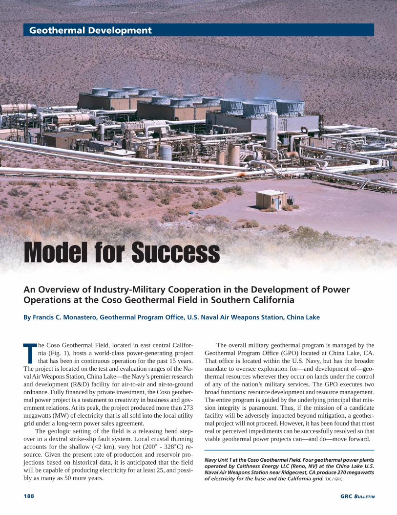
Navy Unit 1 at the Coso Geothermal Field. Four geothermal power plantsoperated by Caithness Energy LLC (Reno, NV) at the China Lake U.S.Naval Air Weapons Station near Ridgecrest, CA produce 270 megawattsof electricity for the base and the California grid. TJC / GRC
189SEPTEMBER / OCTOBER 2002
U.S. Geothermal Development
The Coso Field – A World-Class ResourceFour geothermal power plants with nine 30-MW (nameplate) tur-
bine-generator sets are located within the main production area of theCoso Geothermal Field. The power plants were constructed from 1987through 1990. The first unit went on-line in 1987, and the last units wenton-line in early 1990. Unit 1 is a Mitsubishi Heavy Industries product,while Units 2-9 were manufactured by Fuji Electric Co., Ltd. Total elec-tricity production from the field since 1987 is more than 26,000 giga-watt-hours (GWh), and the units have an on-line availability of morethan 98 percent.
Relatively high temperatures (200° - 328°C) within the field permituse of double-flash technology for steam extraction. Wellhead pressuresrange from 500 psig to 85 psig (low pressure). Production waters areconsidered moderately saline chloride brines with total dissolved solidsranging from 7,000 ppm to 18,000 ppm. Non-condensable gases makeup six percent of the gas fraction, with 98 percent of that amount beingcarbon dioxide. Hydrogen sulfide is in the range of <10 ppm to approxi-mately 85 ppm.
The geothermal field is principally a liquid-dominated system, thoughthere is production in the form of single-phase gas and single-phase liq-uid in different parts of the field. Over the past 15 years, we have foundthat the geothermal system is liquid limited not heat limited. Thus, theboiling interface has been systematically dropping despite the fact thatall available fluid has been injected into the field since the outset of pro-duction. At any given time, there are approximately 80 to 90 productionwells that feed more than 14 million pounds of mass per hour into thesystem. Each turbine-generator set requires one-half million pounds perhour of steam to operate at maximum capacity. Spent brines and conden-
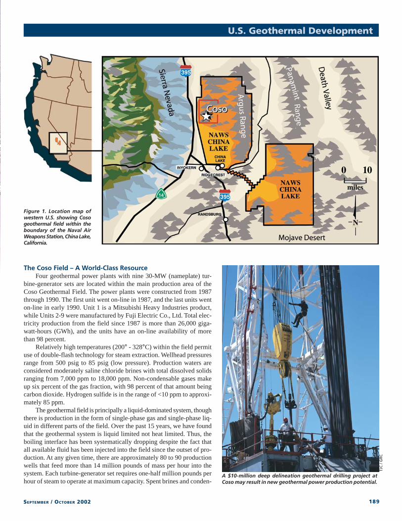
Figure 1. Location map ofwestern U.S. showing Cosogeothermal field within theboundary of the Naval AirWeapons Station, China Lake,California.
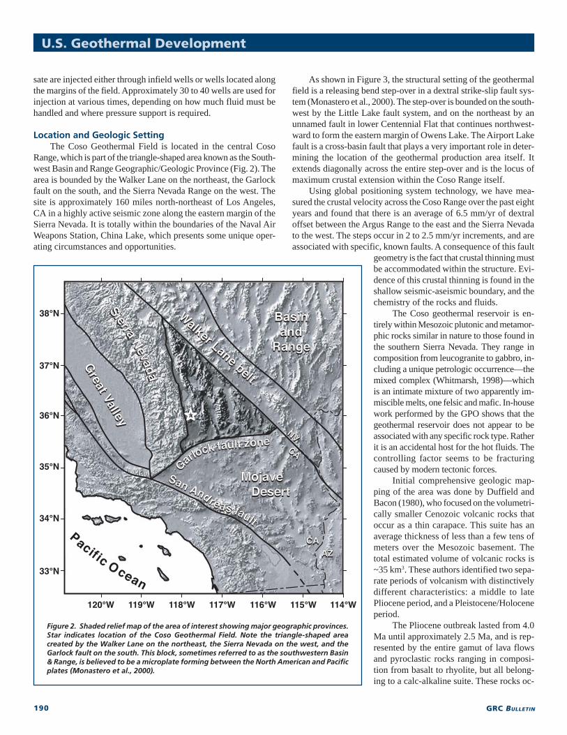
A $10-million deep delineation geothermal drilling project atCoso may result in new geothermal power production potential.
TJC
/ G
RC
190 GRC BULLETIN
U.S. Geothermal Development
sate are injected either through infield wells or wells located alongthe margins of the field. Approximately 30 to 40 wells are used forinjection at various times, depending on how much fluid must behandled and where pressure support is required.
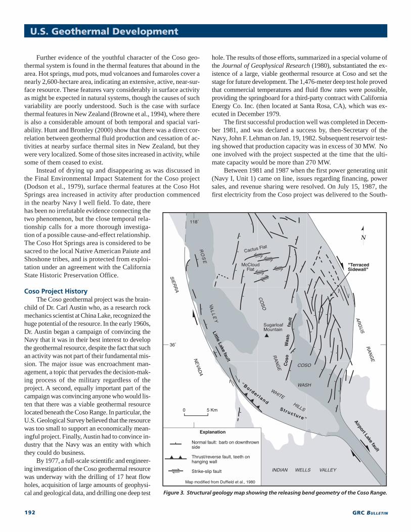
Location and Geologic SettingThe Coso Geothermal Field is located in the central Coso
Range, which is part of the triangle-shaped area known as the South-west Basin and Range Geographic/Geologic Province (Fig. 2). Thearea is bounded by the Walker Lane on the northeast, the Garlockfault on the south, and the Sierra Nevada Range on the west. Thesite is approximately 160 miles north-northeast of Los Angeles,CA in a highly active seismic zone along the eastern margin of theSierra Nevada. It is totally within the boundaries of the Naval AirWeapons Station, China Lake, which presents some unique oper-ating circumstances and opportunities.
As shown in Figure 3, the structural setting of the geothermalfield is a releasing bend step-over in a dextral strike-slip fault sys-tem (Monastero et al., 2000). The step-over is bounded on the south-west by the Little Lake fault system, and on the northeast by anunnamed fault in lower Centennial Flat that continues northwest-ward to form the eastern margin of Owens Lake. The Airport Lakefault is a cross-basin fault that plays a very important role in deter-mining the location of the geothermal production area itself. Itextends diagonally across the entire step-over and is the locus ofmaximum crustal extension within the Coso Range itself.
Using global positioning system technology, we have mea-sured the crustal velocity across the Coso Range over the past eightyears and found that there is an average of 6.5 mm/yr of dextraloffset between the Argus Range to the east and the Sierra Nevadato the west. The steps occur in 2 to 2.5 mm/yr increments, and areassociated with specific, known faults. A consequence of this fault
geometry is the fact that crustal thinning mustbe accommodated within the structure. Evi-dence of this crustal thinning is found in theshallow seismic-aseismic boundary, and thechemistry of the rocks and fluids.
The Coso geothermal reservoir is en-tirely within Mesozoic plutonic and metamor-phic rocks similar in nature to those found inthe southern Sierra Nevada. They range incomposition from leucogranite to gabbro, in-cluding a unique petrologic occurrence—themixed complex (Whitmarsh, 1998)—whichis an intimate mixture of two apparently im-miscible melts, one felsic and mafic. In-housework performed by the GPO shows that thegeothermal reservoir does not appear to beassociated with any specific rock type. Ratherit is an accidental host for the hot fluids. Thecontrolling factor seems to be fracturingcaused by modern tectonic forces.
Initial comprehensive geologic map-ping of the area was done by Duffield andBacon (1980), who focused on the volumetri-cally smaller Cenozoic volcanic rocks thatoccur as a thin carapace. This suite has anaverage thickness of less than a few tens ofmeters over the Mesozoic basement. Thetotal estimated volume of volcanic rocks is~35 km3. These authors identified two sepa-rate periods of volcanism with distinctivelydifferent characteristics: a middle to latePliocene period, and a Pleistocene/Holoceneperiod.
The Pliocene outbreak lasted from 4.0Ma until approximately 2.5 Ma, and is rep-resented by the entire gamut of lava flowsand pyroclastic rocks ranging in composi-tion from basalt to rhyolite, but all belong-ing to a calc-alkaline suite. These rocks oc-
Figure 2. Shaded relief map of the area of interest showing major geographic provinces.Star indicates location of the Coso Geothermal Field. Note the triangle-shaped areacreated by the Walker Lane on the northeast, the Sierra Nevada on the west, and theGarlock fault on the south. This block, sometimes referred to as the southwestern Basin& Range, is believed to be a microplate forming between the North American and Pacificplates (Monastero et al., 2000).
191SEPTEMBER / OCTOBER 2002
cur principally in the eastern part ofthe Coso Range in an area known asWild Horse Mesa, though small out-crops also occur in the central partof the range. The Pliocene volcanicrocks represent approximately 88percent of the total volume ofextrusives found in the Coso area(Duffield et al., 1980). In spite of thefact that they are not the source ofheat for the modern geothermalfield, these Pliocene volcanic rocksplayed an important role in deter-mining the location of the field to-day due to strain softening of thecrust.
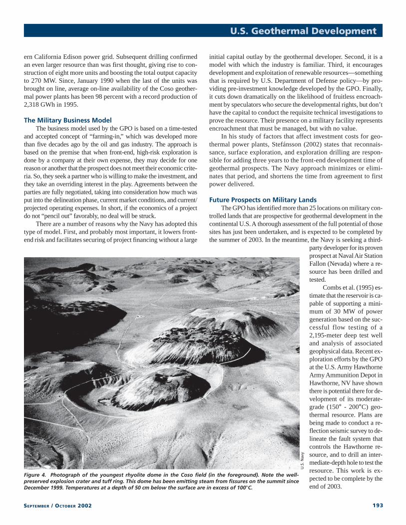
The Pleistocene/Holocene vol-canic rocks are more limited in area,occurring principally in the centraland southern Coso Range. They onlymake up ~12 percent of the total vol-ume of volcanic rocks in the range,are distinctly bimodal in nature, andrange in age from ~2 Ma to 39,000years old (Duffield et al., 1980). Thislatter age is somewhat suspect because of the unreliability of theK/Ar or the 40Ar/39Ar radiometric methods for rocks this young.Compositionally, the Pleistocene/Holocene volcanic rocks are ei-ther high-silica rhyolite or basalt, and they are found in separateareas with little overlap. The rhyolites occur in the central part ofthe Coso Range mostly as thirty-two separate pumiceous, perlitic,endogenous domes. There are very limited occurrences of nearlyaphyric rhyolite lava flows, and silicic pyroclastic material is inthe form of ash-flow tuffs, block and ash flows, and air fall tuffsfilling the topographic lows between domes. There is only oneoccurrence of a well-preserved tuff ring that presumably surroundsthe youngest domes in the field (Fig. 4).
The basaltic rocks occur mostly as flows in the southern andwestern parts of the Coso Range, though there is a significantamount of pyroclastic material associated with the flows. Theyoungest of these flows emanates from a location known as Vol-cano Peak at the southern end of the Coso Range. This flow isdated at 39,000 years, but this date is highly uncertain because ofthe sensitivity limits of the dating method.
Isotope analysis of the Pleistocene-Holocene rocks show thatthey have unusually low 40Sr/39Sr ratios and unusually high e-neody-mium values (Monastero et al., 2000; Groves, 1996). When takentogether, these data indicate that the rocks originated from fractionalcrystallization of an asthenospheric parent, not from crustal con-tamination of a mafic parent. The significance of this observation isthat sometime in the recent geologic past, there has been underplatingof mafic magma derived from asthenospheric material beneath theCoso geothermal area, or mafic dikes derived from asthenosphericmagma have been intruded at relatively shallow depths. These “fresh”magmas provide the heat engine for the geothermal resource.
Because Coso is situated within an active releasing bend struc-ture, we believe that this underplating is also an ongoing process.This theory is consistent with the observation that the field is ap-parently not heat limited. In fact, work done by Manley and Bacon(2000) showed that the field has actually increased by an averageof 30° C over the past one million years, and the magma sourcehas been migrating upward from a depth of 10 km to as shallow as5 km. These observations, too, are consistent with a youthful geo-thermal system.
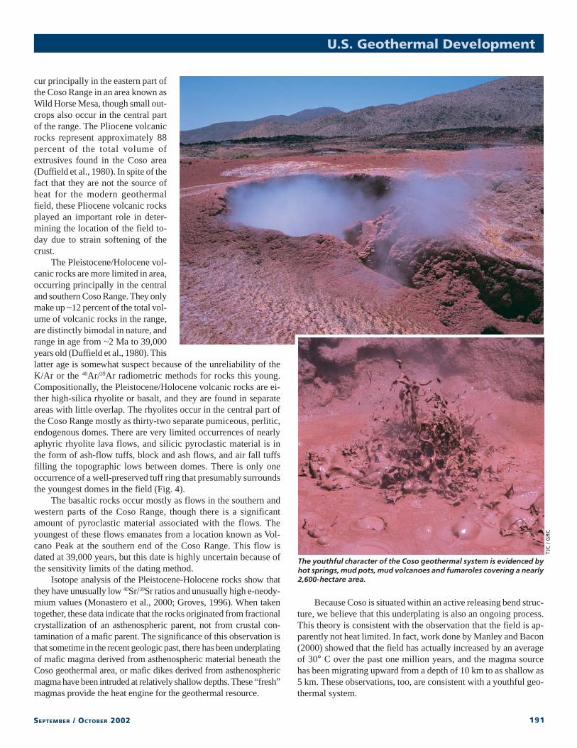
The youthful character of the Coso geothermal system is evidenced byhot springs, mud pots, mud volcanoes and fumaroles covering a nearly2,600-hectare area.
U.S. Geothermal Development
TJC
/ G
RC
192 GRC BULLETIN
Further evidence of the youthful character of the Coso geo-thermal system is found in the thermal features that abound in thearea. Hot springs, mud pots, mud volcanoes and fumaroles cover anearly 2,600-hectare area, indicating an extensive, active, near-sur-face resource. These features vary considerably in surface activityas might be expected in natural systems, though the causes of suchvariability are poorly understood. Such is the case with surfacethermal features in New Zealand (Browne et al., 1994), where thereis also a considerable amount of both temporal and spacial vari-ability. Hunt and Bromley (2000) show that there was a direct cor-relation between geothermal fluid production and cessation of ac-tivities at nearby surface thermal sites in New Zealand, but theywere very localized. Some of those sites increased in activity, whilesome of them ceased to exist.
Instead of drying up and disappearing as was discussed inthe Final Environmental Impact Statement for the Coso project(Dodson et al., 1979), surface thermal features at the Coso HotSprings area increased in activity after production commencedin the nearby Navy I well field. To date, therehas been no irrefutable evidence connecting thetwo phenomenon, but the close temporal rela-tionship calls for a more thorough investiga-tion of a possible cause-and-effect relationship.The Coso Hot Springs area is considered to besacred to the local Native American Paiute andShoshone tribes, and is protected from exploi-tation under an agreement with the CaliforniaState Historic Preservation Office.
Coso Project HistoryThe Coso geothermal project was the brain-
child of Dr. Carl Austin who, as a research rockmechanics scientist at China Lake, recognized thehuge potential of the resource. In the early 1960s,Dr. Austin began a campaign of convincing theNavy that it was in their best interest to developthe geothermal resource, despite the fact that suchan activity was not part of their fundamental mis-sion. The major issue was encroachment man-agement, a topic that pervades the decision-mak-ing process of the military regardless of theproject. A second, equally important part of thecampaign was convincing anyone who would lis-ten that there was a viable geothermal resourcelocated beneath the Coso Range. In particular, theU.S. Geological Survey believed that the resourcewas too small to support an economically mean-ingful project. Finally, Austin had to convince in-dustry that the Navy was an entity with whichthey could do business.
By 1977, a full-scale scientific and engineer-ing investigation of the Coso geothermal resourcewas underway with the drilling of 17 heat flowholes, acquisition of large amounts of geophysi-cal and geological data, and drilling one deep test
hole. The results of those efforts, summarized in a special volume ofthe Journal of Geophysical Research (1980), substantiated the ex-istence of a large, viable geothermal resource at Coso and set thestage for future development. The 1,476-meter deep test hole provedthat commercial temperatures and fluid flow rates were possible,providing the springboard for a third-party contract with CaliforniaEnergy Co. Inc. (then located at Santa Rosa, CA), which was ex-ecuted in December 1979.
The first successful production well was completed in Decem-ber 1981, and was declared a success by, then-Secretary of theNavy, John F. Lehman on Jan. 19, 1982. Subsequent reservoir test-ing showed that production capacity was in excess of 30 MW. Noone involved with the project suspected at the time that the ulti-mate capacity would be more than 270 MW.
Between 1981 and 1987 when the first power generating unit(Navy I, Unit 1) came on line, issues regarding financing, powersales, and revenue sharing were resolved. On July 15, 1987, thefirst electricity from the Coso project was delivered to the South-
Figure 3. Structural geology map showing the releasing bend geometry of the Coso Range.
U.S. Geothermal Development
193SEPTEMBER / OCTOBER 2002
ern California Edison power grid. Subsequent drilling confirmedan even larger resource than was first thought, giving rise to con-struction of eight more units and boosting the total output capacityto 270 MW. Since, January 1990 when the last of the units wasbrought on line, average on-line availability of the Coso geother-mal power plants has been 98 percent with a record production of2,318 GWh in 1995.
The Military Business ModelThe business model used by the GPO is based on a time-tested
and accepted concept of “farming-in,” which was developed morethan five decades ago by the oil and gas industry. The approach isbased on the premise that when front-end, high-risk exploration isdone by a company at their own expense, they may decide for onereason or another that the prospect does not meet their economic crite-ria. So, they seek a partner who is willing to make the investment, andthey take an overriding interest in the play. Agreements between theparties are fully negotiated, taking into consideration how much wasput into the delineation phase, current market conditions, and current/projected operating expenses. In short, if the economics of a projectdo not “pencil out” favorably, no deal will be struck.
There are a number of reasons why the Navy has adopted thistype of model. First, and probably most important, it lowers front-end risk and facilitates securing of project financing without a large
initial capital outlay by the geothermal developer. Second, it is amodel with which the industry is familiar. Third, it encouragesdevelopment and exploitation of renewable resources—somethingthat is required by U.S. Department of Defense policy—by pro-viding pre-investment knowledge developed by the GPO. Finally,it cuts down dramatically on the likelihood of fruitless encroach-ment by speculators who secure the developmental rights, but don’thave the capital to conduct the requisite technical investigations toprove the resource. Their presence on a military facility representsencroachment that must be managed, but with no value.
In his study of factors that affect investment costs for geo-thermal power plants, Stefánsson (2002) states that reconnais-sance, surface exploration, and exploration drilling are respon-sible for adding three years to the front-end development time ofgeothermal prospects. The Navy approach minimizes or elimi-nates that period, and shortens the time from agreement to firstpower delivered.
Future Prospects on Military LandsThe GPO has identified more than 25 locations on military con-
trolled lands that are prospective for geothermal development in thecontinental U.S. A thorough assessment of the full potential of thosesites has just been undertaken, and is expected to be completed bythe summer of 2003. In the meantime, the Navy is seeking a third-
party developer for its provenprospect at Naval Air StationFallon (Nevada) where a re-source has been drilled andtested.
Combs et al. (1995) es-timate that the reservoir is ca-pable of supporting a mini-mum of 30 MW of powergeneration based on the suc-cessful flow testing of a2,195-meter deep test welland analysis of associatedgeophysical data. Recent ex-ploration efforts by the GPOat the U.S. Army HawthorneArmy Ammunition Depot inHawthorne, NV have shownthere is potential there for de-velopment of its moderate-grade (150° - 200°C) geo-thermal resource. Plans arebeing made to conduct a re-flection seismic survey to de-lineate the fault system thatcontrols the Hawthorne re-source, and to drill an inter-mediate-depth hole to test theresource. This work is ex-pected to be complete by theend of 2003.
U.S. Geothermal Development
Figure 4. Photograph of the youngest rhyolite dome in the Coso field (in the foreground). Note the well-preserved explosion crater and tuff ring. This dome has been emitting steam from fissures on the summit sinceDecember 1999. Temperatures at a depth of 50 cm below the surface are in excess of 100°C.
U.S
. Nav
y
194 GRC BULLETIN
Geothermal Development
he earliest written record describing Coso Hot Springs datesto 1860, when a miner at nearby Silver Peak named M.H.Farley mentioned “boiling hot springs to the south.” An 1881
survey of the area by the U.S. government noted “thousands ofhot mud springs of all consistencies and colors,” and early mapsshow “Hot Sulphur Springs” at the location referred to today asCoso Hot Springs.
In 1895, William T. Grant was deeded a quarter interest inthe Coso Hot Springs area, and by 1909, had established a healthresort there. The first documented owner and proprietor of theCoso Hot Springs Resort was Frank Adams, who lived on the sitefrom 1912 until approximately 1920. Some believe that Adamswas hired by Grant and his partner Dr. I.J. Woodin to manage theproperty that they actually owned.
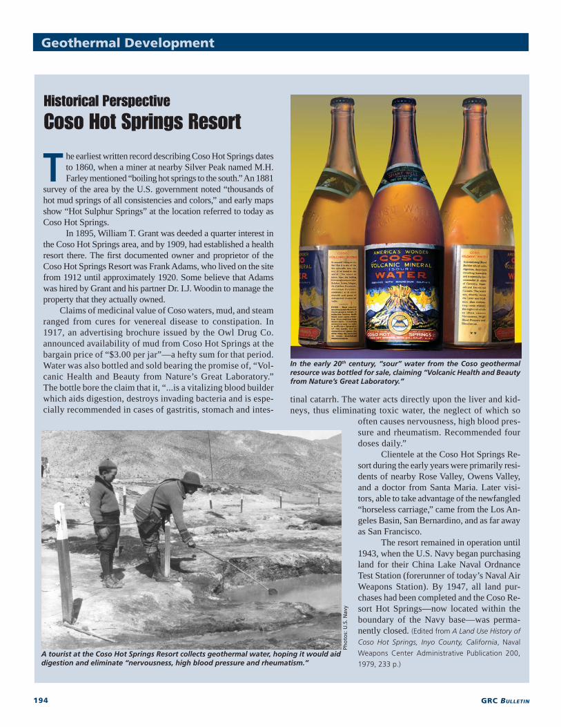
Claims of medicinal value of Coso waters, mud, and steamranged from cures for venereal disease to constipation. In1917, an advertising brochure issued by the Owl Drug Co.announced availability of mud from Coso Hot Springs at thebargain price of “$3.00 per jar”—a hefty sum for that period.Water was also bottled and sold bearing the promise of, “Vol-canic Health and Beauty from Nature’s Great Laboratory.”The bottle bore the claim that it, “...is a vitalizing blood builderwhich aids digestion, destroys invading bacteria and is espe-cially recommended in cases of gastritis, stomach and intes-
T
Pho
tos:
U.S
. Nav
y
tinal catarrh. The water acts directly upon the liver and kid-neys, thus eliminating toxic water, the neglect of which so
often causes nervousness, high blood pres-sure and rheumatism. Recommended fourdoses daily.”
Clientele at the Coso Hot Springs Re-sort during the early years were primarily resi-dents of nearby Rose Valley, Owens Valley,and a doctor from Santa Maria. Later visi-tors, able to take advantage of the newfangled“horseless carriage,” came from the Los An-geles Basin, San Bernardino, and as far awayas San Francisco.
The resort remained in operation until1943, when the U.S. Navy began purchasingland for their China Lake Naval OrdnanceTest Station (forerunner of today’s Naval AirWeapons Station). By 1947, all land pur-chases had been completed and the Coso Re-sort Hot Springs—now located within theboundary of the Navy base—was perma-nently closed. (Edited from A Land Use History of
Coso Hot Springs, Inyo County, California, Naval
Weapons Center Administrative Publication 200,
1979, 233 p.)
In the early 20th century, “sour” water from the Coso geothermalresource was bottled for sale, claiming “Volcanic Health and Beautyfrom Nature’s Great Laboratory.”
A tourist at the Coso Hot Springs Resort collects geothermal water, hoping it would aiddigestion and eliminate “nervousness, high blood pressure and rheumatism.”