Embed Size (px)
Citation preview

^^
^^̂^̂^
^̂^^̂
^̂^̂
^̂
^̂ ^^̂^̂
^̂^
^̂ ^̂^̂ ^^
^̂^^̂
^̂^̂
^̂^̂
^^̂
^̂^
^̂^̂^
l
¥
¥
¥ ??!R
>>
#
¥
&
&
&
Feat.1
Feat.2
Feat.3
Corral 1
Feat.4
AC-1
5160'
µ
Site 42GA6302 - Wide Valley Camp& Featurel Historic Artifact
¥ Axcut Tree
? Axcut Juniper Branches
> Juniper Post!R Wooden Trough# chipped wood pile
Drainage^̂ ^ Rock Rim
Contour Line
FeatureCorralArtifact ConcentrationSite Boundary
8 0 8 16 24Meters
25 0 25 50 75 100Feet

M
C
CR
&
!(
&
#
Kiva
PossibleTower
AC-1
5600'
1
1
2
1(692383ME,4145503MN)
µ
Site 5MT21949# Datum
& Kiva or Tower
!( Depression
C Core
M Metate
R Retouched Flake
WallYellow JacketCreekTopographicChangeContour Line
ArtifactConcentrationPit Structure
Large Pit Structure
Room 1
Two-story Portionof Room BlockRoom Block
Rubble
Depression
Site Boundary
5 0 5 10 15Meters
25 0 25 50Feet
RB-4
RB-1
RB-3RB-2PS
LPSRubble Mound 2
Rubble Mound 1

!!! !!
!!
!
!!!
!!
!
m
O
O
ò ò ò O
#")E
")E
òò
ò ò
òòò
ò òòò
ò
ò
òò
ò
ò
òò ò
ò
ò
ò
ò
O
ATU-1
ATU-2
5920'
5880'
5920'5880'
5840'
5800'
5760'
5720'
5680'
5680'
5680'
(693845ME,4145112MN)
µ
Site 5MT21947 - Harris# Datumò Kiva
O Tower")E
Artifact TallyUnit
m Mano
Wall!!!!!!! ! ! ! ! !
RockAlignmentCliffSteepSlickrock Edge
Contour LineBoulderInferred RoomBlock
Two StoryRoom BlockRubbleProject AreaBoundarySite Boundary
20 0 20 40 60Meters
50 0 50 100 150 200 250 300Feet
Alexander West Project Area

^
^̂^̂^̂^̂^^̂
")
!¥
öXWö
>
>
ö
W
5400'
5360'
5320'
5360'
µ
Site 42GA7641 - Chaffin Camp> Fence Post
ö Fire Ring - Modern
W Rock Pile
ö Fire Ring
!¥ Chainsaw Cut Tree Trunk
") Chest Freezer
XW Posts and Planks in Tree
Drainage
Fence
^̂ ^ Rock Rim
Reservoir Dam
Contour Line
Site Boundary
30 0 30 60Meters
100 0 100 200 300 400Feet
^̂
^̂^̂^̂^̂^̂^̂^̂^̂^̂^̂
^̂^̂
^
^̂
^̂^̂
^̂
!R#
5320'
Wö
!R
l !R
l
Trough 2
StoveTrough 3
MetalWaterPipe
AC-1 5320'
25 0 25 50 75Feet!R Trough
# Pile of MortarBags
Hitching Post
Pipe
Drive Chute
Drainage
Fence
Gate
^̂ ^ Rock Rim
15 0 15 30 45Feet
l Historic Artifact
!R Trough
ö Fire Ring
W Rock Pile
Artifact Concentration
Trough 1

^̂^̂^̂
^̂ ^̂ ^̂ ^^̂^̂^̂^̂^
^̂^̂^̂^̂
^̂ ^̂ ^̂^̂^̂^̂
^̂ ^^̂^̂
^̂^̂
^^̂ ^̂ ^^
^̂ ^̂^̂
^^̂ ^̂ ^̂
^̂^̂^̂^̂^̂^̂^^̂
^̂^
^̂^̂
^̂^̂^̂^̂^̂^̂^̂^^̂
^̂^̂
^̂^̂
^̂
F 1
F 10 F 13
F 2
F 3F 4
F 5
F 6
F 7
F 8
F 9
F 11F 12
219
217
218
220
225
205201
207
213
221
206
202
208
214
222
223
215
209
203 212204
210
216
228
229
230
211
227
226
µ
5RT90Base of SlopeBedrock Intrusionfrom Cliff
^̂ ^Cliff Face atModern GroundLevelEdge of SedimentShelf
FeatureExcavation UnitPreviousExcavation Block
0.5 0 0.5 1 1.5Meters
2 0 2 4 6Feet
224

ÍÍÍÍ
ÍÍÍÍ
ÍÍÍ
ÍÍÍÍ
Í
ÍÍÍÍ
ÍÍÍÍ
ÍÍÍÍ
ÍÍÍÍ
ÍÍÍ
ÍÍÍÍ
Í
ÍÍÍÍ
ÍÍÍÍ
ÍÍÍÍ
ÍÍÍÍ
ÍÍÍ
ÍÍÍÍ
Í
úú
úú
ú
úú
ú
ú
úú
úú
ú
úú
ú
ú
úú
úú
úú
ú
ú
ú
úú
ú
ú
ú
ú
úú
ú
ú úú
ú úú ú
ú
ú
500,500
500,501
500,504
500,503
500,502
500,505
µ
5RT90 - North Wall ProfileExcavation Unit LineFeature
ÍÍÍÍÍÍÍÍÍÍÍÍÍÍÍ
úúúúúúMottled Soil
Organic Mat
KrotovinaRockRootAsh Lens
Sand LensStratum 1Stratum 2Stratum 3
Stratum 3BStratum 4Sandstone Bedrock
43B
33F2
2
1
1
2
3
3B
4
35 0 35 70 105Centimeters
12 0 12 24 36 48Inches

ÍÍÍÍúúúú
!>
!>!>
!>
A
A'
F5
196N200E
Pipeline Trench Pipeline Trench
F1
culturallense
267
262
251
250
239
238
268264265266
270
261260259258257
252253254255256
249248247
246245
240241242
243244
237236235234233
269
263
µ
E
RipperTrench
PipelineTrench
23
2
32
3
A A'
Block 1 Plan and Profile!> Discovery FeatureE Faunal
Profile Location
FeatureExcavation UnitFire-cracked Rock
Sandstone Cobble
ÍÍÍÍÍÍÍÍÍÍÍÍ
úúúúúúúúúúúú
Ground StoneRockStratum 2Stratum 3
1 0 1 2 3Meters
0.5 0 0.5 1 1.5Meters
2
3

90 cmbd110 cmbd
150 cmbd
235
245243 246
227240
231
219230234
233
244
220
218
232
203
µ
House 1 Plan and Profile MapHouse 1House 1 Inner EdgeExcavation Block
Fire-cracked RockMetate
RockSandstone SlabTrench
Stratum 1Stratum 2Stratum 3
0.25 0 0.25 0.5 0.75 1Meters
A A'
A A'
1
32
1
1
2
3
F9
PD 234.1.1

Feature 15 Feature 18Bisection LinePre-ExcavationBoundaryFeatureStratum F1Stratum F2Charcoal
GraderDisturbanceOxidationFire-crackedRockKrotovinaUnexcavated
¹¹A
A'
A A'
A A'
Bisection LineOxidized RimFeatureKrotovinaUnexcavated
A A'
15 0 15 30 45 60Centimeters
F1
F2
F1
F1
F2

NiobraraConverse
GoshenPlatte
µ
Study Area BoundarySensitivity Area
LowMediumHigh
Niobrara
Platte Goshen
Converse
Niobrara
Platte Goshen
Converse
5,000 0 5,000 10,000 15,000 20,000Meters
2 0 2 4 6 8 10 12 14Miles
Model A Model B
Model C

µFigure 23. Analytically derived sensitivity map for prehistoric sites in the DENCA.
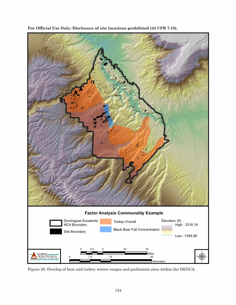
135
For Official Use Only: Disclosure of site locations prohibited (43 CFR 7.18).
Prehistoric Site Sensitivity Model within the DENCADENCABoundaryManagement Zone
LowMedium
High
0 15 307.5Kilometers
0 5 10 152.5Miles
Dominguez Canyon Wilderness Area
Wagon Park
Cactus Park The Hunting Ground
Gunnison River
Sawmill Mesa

µ
For Official Use Only: Disclosure of site locations prohibited (43 CFR 7.18).
Factor Analysis Communality ExampleDominguez-EscalanteNCA BoundarySite Boundary
Turkey OverallBlack Bear Fall Concentration
Elevation (ft)High : 3318.19
Low : 1399.98
0 15 307.5Kilometers
0 5 10 152.5Miles
Figure 20. Overlap of bear and turkey winter ranges and prehistoric sites within the DENCA.
124

_̂
48CR7309
µ
The Daley Ranch Site (48CR7309)_̂ Site Location Hypothetical Annual Range
Elk Winter RangeElevation Below 7000'Elevation 7000' - 9000'Elevation 9000'+
_̂
48CR7309
0 10 20 30 40 505Miles
0 20 40 60 80 10010Kilometers