Embed Size (px)
Citation preview
“ संचित जल, सुरषित कल “ जल संरिण व्ष - 2013
Technical Series: E For official use only
Government of India
Ministry of Water Resources
CENTRAL GROUND WATER BOARD
GROUND WATER INFORMATION BOOKLET
HAMIRPUR DISTRICT, HIMACHAL PRADESH
NORTHERN HIMALAYAN REGION
DHARAMSALA
September, 2013
“ संचित जल, सुरषित कल “ जल संरिण व्ष - 2013
Contributors
Rachna Bhatti
Assistant Hydrogeologist
Prepared under the guidance of
Sh. J.S.Sharma
Head of Office
&
Sh. Dalel Singh
Suptdg. Hydrologist
Our Vision
Water security through sound groundwater
management
“ संचित जल, सुरषित कल “ जल संरिण व्ष - 2013
Ground Water Information Booklet
Hamirpur District, Himachal Pradesh
CONTENTS
DISTRICT AT A GLANCE
Page No.
1.0 INTRODUCTION
1.
2.0 CLIMATE & RAINFALL
4.
3.0 GEOMORPHOLOGY & SOILS
4.
4.0 GROUND WATER SCENARIO
7.
4.1 Hydrogeology 7.
4.2 Ground Water Resources 11.
4.3 Ground Water Quality 11.
4.4 Status of Ground Water Development 11.
5.0 GROUND WATER MANAGEMENT STRATEGY
12.
5.1 Ground Water Development 12.
5.2 Water Conservation & Artificial Recharge 12.
6.0 GROUND WATER RELATED ISSUES & PROBLEMS
14.
7.0 AWARENESS & TRAINING ACTIVITY 14.
8.0 AREAS NOTIFIED BY CGWA / SGWA 15
9.0 RECOMMENDATIONS 15.

“ संचित जल, सुरषित कल “ जल संरिण व्ष - 2013
HAMIRPUR DISTRICT AT A GLANCE
Sl.
No
Items
Statistics
1. GENERAL INFORMATION
i) Geographical area (sq km) 1,118
ii) Administrative Divisions (2001)
Number of Tehsil & sub-tehsils 5 &1
Number of CD Blocks 6
Number of Panchayats 229
Number of Villages 1,672
iii) Population (2011 Census) Total population Population Density (pers/sq km) Rural & Urban Population SC & ST Population (in percent) Sex Ratio
4,54,768
407
93.1% & 6.9%
24 % & 0.67%
1,095
iv) Average Annual Rainfall (mm) 1,340.72
2. GEOMORPHOLOGY
Major Physiographic units Structural hills & upland
(elevation 600–900 m amsl) Valley/ alluvial plain
(Elevation 400-600 m amsl)
Major Drainages Beas basin
Kunnah, Man, Sukar, Sir Khad
3. LAND USE (2008-09) in Hectare
Forest area 18,200
Total cropped area 68,800
4. MAJOR SOIL TYPES Alluvial soil Non-calcic soil
5. AREA UNDER PRINCIPAL CROPS
(2008-2009) in ha.
Rice 1,995
Wheat 34,064
Maize 31,704
Barley 57
Pulses 36
6.
IRRIGATION BY DIFFERENT
SOURCES (ha.)
Net area irrigated (2008-09) 1,784
7. NUMBERS OF GROUND WATER
MONITORING WELLS OF CGWB
(As on 31.3.2013)
Number of Dug Wells 4
Pre-monsoon water level (May, 12) 2.73 – 8.59 m bgl
Post-monsoon water level (Nov, 12) 2.47 – 9.97 m bgl
Number of Piezometers Nil

“ संचित जल, सुरषित कल “ जल संरिण व्ष - 2013
8. PREDOMINANT GEOLOGICAL
FORMATIONS
Alluvium/valley-fill
(Quaternary) Siwalik Group
(Tertiary)
9. HYDROGEOLOGY
Major Water Bearing Formations
1. Semi consolidated sediments
(Siwalik Group)
Covers major part
Yield prospects Low to moderate (1-5 lps)
GW structures Springs, open wells & tube wells
2. Unconsolidated porous sediments
(Alluvium)
Along rivers and low lying areas
Yield prospects Low to moderate (1-5 lps)
GW structures feasible Open wells & tube wells
10 GROUND WATER EXPLORATION BY
CGWB (as on 31.3.2013)
No of wells drilled 10 (EW-10: OW-0)
Depth Range (m) 40 – 100
Discharge (lpm) 20 – 1078
Static Water Level 1.23 – 9.60 m bgl
Transmissivity (m2/day) 7.61 – 712
11. GROUND WATER QUALITY
Presence of Chemical constituents more
than permissible limits (eg. EC, F, As, Fe)
Nil
Quality of Ground Water
(EC Range in µS/cm)
Good
(233 – 560)
12 ARTIFICIAL RECHARGE PROJECTS
Implemented One Project
Under implementation Six Projects
13. AWARENESS AND TRAINING
ACTIVITY
Mass Awareness Programmes Place No of participants in persons
1
Agriculture Department, Hamirpur
200
14. GROUND WATER CONTROL AND
REGULATION
Number of OE & Critical Blocks Nil
No of blocks notified Nil

“ सं�चत जल, सुर �त कल “
“ जल संर�ण वष� - 2013 ”
1 | P a g e
DISTRICT GROUND WATER BOOKLET
HAMIRPUR DISTRICT, HIMACHAL PRADESH
1.0 INTRODUCTION
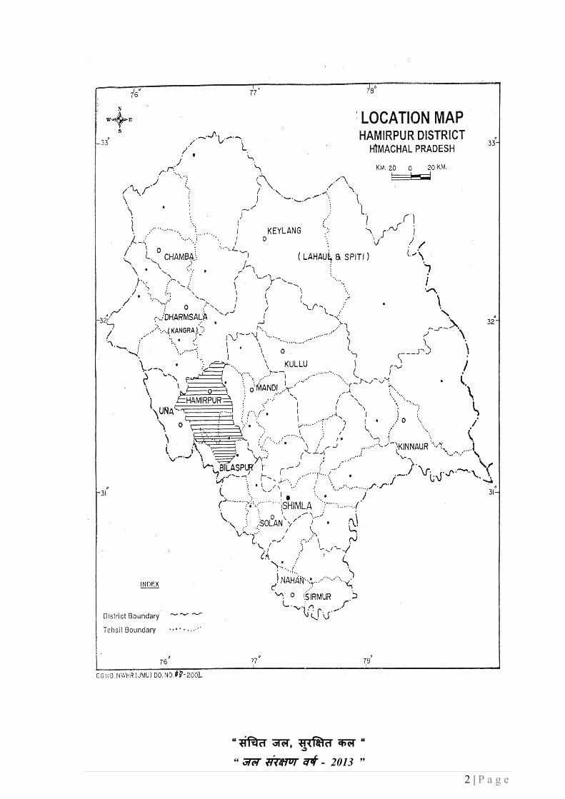
Hamirpur was a part of Kangra district when it was in the composite Punjab. Prior to that, it
was a tehsil of district Kangra. Hamirpur is a sparsely populated, centrally located district of
the state. The district lies between 31023’00” and 31
053”00” north latitude and 76°20’00”
and 77°45’00” east longitude. It is bounded on the east by Mandi district, on the northwest
by Kangra district, on the south & southwest by Bilaspur and Una districts respectively. The
district has a total area of 1,118 sq km and covers 1.97 % of the state. It has a total number of
229 Panchayats.
As per 2011 census, the district has a population of 4,54,768 persons with a population
density of 407 persons per sq km. The male and female population in the district is 2,17,070
and 2,37,698 respectively, with a sex ratio of 1,095 females per 1,000 males. The schedule
cast population in the district is 24 % and the schedule tribe population is 0.67%.
Hamirpur district forms a part of Changer Belt, which is an acute water scarcity area of
Himachal Pradesh and experiences almost severe drought conditions. The water requirement
of general public is being met from traditional water sources like springs, percolation wells,
step wells and streams. Khatris/traditional water harvesting structures are very common in
the northern part of the district in and around Sujanpur-Sachui-Patlandar-Ahwa Devi areas.
Khatris are constructed in conglomeratic terrain, in which seepage water along with
rainwater is collected in the under-ground storage for domestic purpose during lean period.
Traditional methods of water harvesting like roof top rainwater and collection of rain water
in tanks called Talavs are still in practice.
Hamirpur district with it’s headquarter at Hamirpur comprises of three subdivisions
(Hamirpur, Badsar, and Nadaun) and five tehsils (Hamirpur, Badsar, Bhoranj, Nadaun, and
Sujanpur-Tira). The district is also subdivided into five blocks namely; Bijri, Bhoranj,
Nadaun, Hamirpur, and Sujanpur-Tira.
The district is approachable by all weather national and state highways, except Nadaun
valley, Sachui- Sujanpur valley and other valley fill deposits along the Sir, Kunah, Sukar and
Man Khad, the district is mostly hilly and undulating. The cultivation is possible in small
terraces and valley fill deposits along the stream/khad basins in most parts of the district. In
the valleys the cultivation is spread over a vast area, except the valley area and stream/khad
basins. Most of the land is either under shrub forests or grassy land with Chir trees up to the
height of 1100 m from the mean sea level. Agriculture is the primary occupation of the
people in the district.
Central Ground Water Board (CCWB) has carried out Hydro-geological Studies and
Groundwater Exploration in the district. Exploratory drilling has been carried out in
Hamirpur district all along the valley fills. Under ground water exploration, 10 boreholes has
been drilled down to the depth ranging from 40 m at Sachuhi to maximum of 100 m at
Chinjiani. The depth to static water level varies from 1.23 to 9.60 m and discharge varies
from 20 lpm at Badehar to 1078 lpm at Harmandir
CGWB under its National Hydrograph Network Station monitors 4 wells for ground water
regime monitoring, where water level and ground water quality is monitored.
“ सं�चत जल, सुर �त कल “
“ जल संर�ण वष� - 2013 ”
2 | P a g e

“ सं�चत जल, सुर �त कल “
“ जल संर�ण वष� - 2013 ”
3 | P a g e
31 31

“ सं�चत जल, सुर �त कल “
“ जल संर�ण वष� - 2013 ”
4 | P a g e
2.0 CLIMATE & RAINFALL
Climate in various parts of the district, depend primarily much on the elevation, which varies
from less than 200 meters to more than 1000 meters above mean sea level. The climate can
broadly be divided into three broad seasons viz. winters from October to March, summer
season from April to June and monsoon season from July to September. The district receives
moderate rainfall and bulk of it is received during the months of July and August. The
average annual rainfall in the district is 1,340.72 mm, out of which 82% occurs during June
to Sept.
3.0 GEOMORPHOLOGY & SOILS
The terrain of the district is mostly hilly and undulating. The surface elevation ranges from
400 m to 600 m amsl along the Beas river valley and in lower reaches of Kunah Khad in the
northern part of the district. The elevation is more than 900 m above msl in the eastern part
of the district. The altitudinal variation in-general, ranges between 600 m to 900 m above
msl. Sola Singhi hill ranges forms the western boundary of the district, with a maximum
elevation of 1145 m above msl. Deep gulleys and gorges are formed in the north-eastern part
of the district. The river / khad valleys are broad in the southern part of the district, mainly
along the Sukar and Sir Khad in Bhorang-Jahu-Dhankar areas. In the drainage basin of Beas
River, the general ground slope is towards north, while in the Sutlej River this slope is
towards south.
Hamirpur district forms a part of drainage system of the Beas River in the northern and
western parts, whereas in the eastern and southern parts Sutlej River system drains the areas .
The drainage pattern is dendritic to sub dendritic. Drainage density is coarse to medium.
The Beas River: The entire drainage of the Beas River above Pandoh (Mandi) has been
diverted to Govind Sagar (The Sutlej River).The river receives only regulated flows
downstream of Pandoh and the flows contributed by the Uhl River, Neogal Khad and Binwa
Khad along with the other minor seasonal rivers/Khads directly join the river Beas. Other
important tributaries of Beas are Baker, Salagi, Nauli, Maili and Jangled Khads. In
Hamirpur district’s, Kunah and Man khads are the major streams. These along with other
major khads join the Beas River.
Kunah Khad: Kunah is the most important tributary of the Beas River in the district. .
Major tributaries of this khad are Sukar, Jhaniari, Gasota, Hathali and Sukrala Khads. These
khads are perennial and have floods during rainy season.
Man Khad: Man Khad is another perennial tributary of Beas River which originates near
Deotsidh and flows towards NNW, to join Beas River to the west of Nadaun. Important
tributaries of this khad are Haretta, Bambloo and Matwara Khads.
Sukkar Khad: Sukkar and Sir Khads are the main khads joining the Sutlej River and
Govind Sagar. These occupy the southernmost part of the district and flow towards south to
directly fall into the Govind Sagar. These are ephemeral in the upper parts and become
perennial in the lower parts.
Sir Khad: Sir Khad is another important khad, which is draining the eastern most part and
flows towards east. This khad is ephemeral in upper catchment area and becomes perennial
in lower parts.

“ सं�चत जल, सुर �त कल “
“ जल संर�ण वष� - 2013 ”
5 | P a g e
District HQ
Tehsil HQ
31 31

“ सं�चत जल, सुर �त कल “
“ जल संर�ण वष� - 2013 ”
6 | P a g e
31
31
31
31
Minor

“ सं�चत जल, सुर �त कल “
“ जल संर�ण वष� - 2013 ”
7 | P a g e
In addition to these khads there are other numerous minor streams/khads joining the Sutlej
River. There are number of minor surface water storage tanks located in the district, called
Talavs or Tanks. Almost all the villages have a Talav / Tank to fulfill the domestic water
requirements. There is no natural lake existing in the district.
4.0 GROUND WATER SCENARIO
4.1 Hydrogeology
There are two main geological horizons, namely post-tertiary and tertiary formations
in Hamirpur district. The sequence of geological formation is given as follows
AGE FORMATION LITHOLOGY
Post-Tertiary
(Quaternary)
Alluvium Sand, Gravel, Pebble & Boulders and
clay
Tertiary
(Siwalik)
Upper Conglomerates, Boulders and pebbly
sandstone
Middle Micaceous sandstone and shale
Lower Hard, purple sandstone & shale
TERTIARY FORMATIONS
Almost the entire district is underlain by the tertiary formations. These formations are
represented by the Siwalik group of rocks (lower, middle and upper). Lower Siwaliks
comprise of massive dark gray sandstone and purple shales. These are conformably overlain
by micaceous sandstone and gray clay/shales of middle Siwalik. Upper Siwaliks comprise of
conglomerates, coarse-grained sandstones, inter bedded with grey and pink clays/silts and
sand stone or pebbles beds. Conglomerates occupy the major part of the district.
Conglomerates are compact and hard in northern part, while in south-eastern parts these are
weathered and fractured.
OLDER ALLUVIUM DEPOSITS
These are widely distributed in the area between Nadaun – Sandhol and Harsi Pattan along
the Beas River and Jahu-Bhorang area along Sir khad. Older alluvial deposits also occur in
the lower reaches of Man khad. Alluvial deposits are also formed along minor streams /
tributaries. These deposits are discontinuous and are of limited aerial extent. Thickness of
these deposits varies from less than 10 m to about 100 m along the Beas River valley and Sir
Khad.
YOUNGER ALLUVIUM
These deposits occur either along the active channel or adjacent to it. The width of these
deposits varies from few meters to about a kilometer. These are distributed along the major
and minor streams/rivers. Pebbly sandstone is also occurring in the district, which is highly,
weathered and fractured. Springs are formed along or near to the thrust zones traversing
through the central part of the district.

“ सं�चत जल, सुर �त कल “
“ जल संर�ण वष� - 2013 ”
8 | P a g e
Alluvium 4
Upper Siwaliks 3A Conglomerate (compact)
Boulder Beds and Conglomerates
Middle Siwaliks 3 3 (Sand Stone and Clay)
Lower Siwaliks 2 Clay and sand stone
Thrust / Fault 1
31
31
“ सं�चत जल, सुर �त कल “
“ जल संर�ण वष� - 2013 ”
9 | P a g e
31
31
31
31

“ सं�चत जल, सुर �त कल “
“ जल संर�ण वष� - 2013 ”
10 | P a g e
POST –TERTIARY FORMATIONS
Quaternary deposits forming valley fill deposits are fluvial deposits. These deposits rest
uncomfortably over the Siwaliks, with more thickness in low topographical areas along the
rivers/khads. These sediments are composed of sand, gravel, pebble and boulders. Mostly
these are formed by the coalescence of the alluvial fan deposits by the various rivers/khads.
AQUIFER SYSTEM
1. SEDIMENTRY FORMATIONS
Sedimentary formations comprise of hard rocks belonging to Siwalik group of rocks and are
represented by conglomerates, boulder beds and sandstones and clays. Conglomerates and
boulder beds are compact and hard, are generally devoid of water bearing horizons and are
widely distributed in the eastern part of the district. Weathered conglomeratic formations
overlying the compact conglomerates, form shallow and potential aquifers mainly in
topographic lows. Ground water is developed by construction of percolation wells, galleries
or through springs. The discharge of wells varies from less than 1 lps to about 10 lps.
Discharge generally reduces during summers. In compact conglomeratic formations ground
water occurs generally either along the fractures/fault zones or along the contact zones of
different lithological units. Ground water is developed only in the form of springs, formed in
the low topographic areas, along the fractured zones. The discharge of the springs is meager
and is utilized for domestic purposes. Most of the springs in this zone also get dried up
during peak summers.
Contact and fractured zones, in sandstone formations mainly near the major faults or thrusts
form the potential zones. These are widely distributed in the central and western part of the
district. In these areas, ground water is mainly developed through the springs. Ground water
generally occurs under unconfined conditions. Depth to water level varies from 5m to about
10 m. The yields of shallow wells are meager and are utilized only for domestic purposes.
The development of deeper ground water horizons has commenced with the introduction of
borewells for installing hand pumps, ranging in depth from 40 m to 80 m spread over the
entire district. Depth to water in these borewells generally ranges between 10 m to 25 m
below ground level. The yield of borewells (during drilling), reportedly varies from less than
one litre to about 2 litre per second (LPS). Yields are generally higher along the structurally
weak zones. Ground water is mainly discharged through springs. Important springs are
formed along or near to the thrust zones traversing through the central part of the district.
II. POROUS FORMATIONS:
Quaternary sediments or fluvitile deposits occur as valley fill within the older formations,
distributed mainly along Beas River, Sir khad and Man khads. Fluviatile deposits are loose to
semi consolidated, comprising of sand, clay, gravel, silt, pebble and boulders. The important
valley fill deposits along Beas River of the district are discussed below.
VALLEY FILL ALONG BEAS RIVER
SACHUHI-SUJANPUR VALLEY FILL
This is an important valley fill formed along the southern bank of the Beas River and locally
known as Ballas. This area was prone to floods with waters of Beas River during rainy
season prior to the diversion of the Beas river’s water to Govind Sagar, at Pandoh. This has
also checked the floods and improved the marshy lands (Ox-bow), previously existing over
the areas around Jangal Bary and Sachuhi.

“ सं�चत जल, सुर �त कल “
“ जल संर�ण वष� - 2013 ”
11 | P a g e
4.2 Ground Water Resources
Ground water resources and irrigation potential of Hamirpur district has not been computed
as per the GEC-97 methodology, as the aquifers are isolated and discontinuous in nature.
Ground water draft component consists of draft due to bore wells discharge through springs
and effluent seepages into the rivers.
4.3 Ground Water Quality
Water samples were collected from Ground Water Monitoring Stations during May, 2012,
for chemical analysis. The minimum and maximum ranges of the results are tabulated below
and are within the permissible limit of safe drinking water set by Bureau of Indian Standard
(BIS).
pH
EC
µS/cm
at 25°C
HCO3 Cl So4 NO3 F Ca Mg Na K
Total Hard
ness
as CaCO3
(in mg/l)
Min 8.02 280 12 10 1 2 Tr 30 11 7.5 0.6 120
Max 8.17 360 153 125 85 22 0.16 48 17 14.0 5.8 165
4.4 Status of Ground Water Development
The population of the district is widely distributed and their water demands are fulfilled to
larger extent, from the traditional water sources like springs, percolation well/ infiltration
galleries, step-wells and streams, by piped water supplies.
Major potential areas for the ground water development are the valley fill deposits, occurring
along Beas River between Sachuhi and Nadaun, lower reaches of Man khad and Sir khad and
central part of Kunah khad. The aquifer thickness may vary from less than 10 m to about 100
m. The other potential areas are located along the faults/thrusts and contact zones of various
formations. Majority of the springs are located along these weak zones. In most of the areas,
bore wells have been constructed with yields varying from less than 1 lps to 5 lps. The bore
wells with higher discharges (more than 1.5 lps) are fitted with electric motors to augment
the water supplies.
So far, the valley fills or fault zones has not been explored or studied on macro level for
assessing the potentialities of ground water resources in the district. However, Central
Ground Water Board has taken up exploration, in Jangal-Berri-Sachuhi area and central part
of Kunah Khad by constructing tube wells for studying the aquifer parameters, in order to
assess the ground water resources.
Rainfall infiltration is the principal source of ground water recharge to the aquifer system in
the district. Inflow seepages from khads/ rivers also contribute to the ground water resources/
reserves.

“ सं�चत जल, सुर �त कल “
“ जल संर�ण वष� - 2013 ”
12 | P a g e
5.0 GROUND WATER MANAGEMENT STRATEGY
5.1 Ground Water Development
Hamirpur is partially explored and only ten exploratory wells are constructed, in which
shallow aquifers are tapped. Some of the wells have been handed over to Irrigation & Public
Health Department. All these wells are drilled all along the Beas River and its tributaries in
the district. Lot of scope exists, for the future ground water development in the district.
In Hamirpur district, ground water occurs under water table to semi-confined conditions.
Sedimentary formations comprise of hard rocks belonging to Siwalik Group and are
represented by conglomerates, boulder beds, sandstones and clays. Conglomerates and
boulder beds are compact and hard, generally devoid of water bearing horizons and are
widely distributed in the eastern part of the district. Weathered conglomeratic formations,
overlying the compact conglomerates form shallow and potential aquifers, mainly in
topographic low lying areas. Fissured formations includes, Quaternary sediments or fluvitile
deposits and occur as valley fills, within the older formations and are distributed mainly
along Beas River, Sir Khad and Man Khads. Fluviatile deposits are loose to semi
consolidated comprising of sand, clay, gravel, silt, pebble and boulders.
5.2 Water Conservation & Artificial Recharge
In Hamirpur district, development of ground water resources can be categorized into two
distinct areas and is ultimately related to the varied topography and geological characteristics
of the area. Because of hilly topography of the area, ground water structures especially
traditional sources are of great value. However in valley areas, modern techniques are
supplementing the old one. Such type of development is taking place in some part of the
district. The various means for tapping the ground water resource is summarized below in
two main physiographic units.
1. Hilly Areas
2. Valley Areas
1. Hilly Areas: -
In hilly areas of Hamirpur district, springs are the main source of ground water. In local
language, these are known by various names like Bowris, chasmas, magars etc. However
the difference lies only in the way these are tapped. The spring water thus collected in
artificially constructed tank structure, is ultimately used for drinking and other domestic
purposes. The discharge of the spring varies from seepages to maximum of 21 lps. Few
springs having sufficient discharge are being tapped by the State agencies like Irrigation &
Public Health Department under various schemes. Some of the existing water supply
schemes are successfully running on such sources for serving the settlements.
Hand pumps are another source of ground water, tapped for domestic use. State agencies
have constructed number of hand pumps and its water is being used for drinking and other
domestic purposes. Some of the hand pumps having sufficient discharge are tapped by I.P.H.
department and its water is ultimately used for water supply.
Valley areas of Hamirpur district are comparatively densely populated. This reflects the
demand for more water for domestic and agriculture purpose. Such areas are primarily
served by various lift water supply schemes by State agencies. Most of these schemes are
established on major rivers, tributaries or streams/nallas having sufficient perennial
discharge.

“ सं�चत जल, सुर �त कल “
“ जल संर�ण वष� - 2013 ”
13 | P a g e
31
31 31
31

“ सं�चत जल, सुर �त कल “
“ जल संर�ण वष� - 2013 ”
14 | P a g e
2. Valley Areas: -
Springs are natural ground water structures used for domestic purposes. Such spring sources
are generally found to be well maintained by local community. The discharge of the spring
sources varies from seepages to few lps.
Though the stage of ground water development in the district is still in safe category,
however, declining water levels in patches suggest need for cautious and well-planned
ground water development. Further, there is an urgent need to monitor development pattern
by the implementing agencies.
Roof top rainwater harvesting in urban/rural areas and water harvesting in rural area need to
be adopted and proper scientific intervention for spring development and revival of
traditional water storage, is required in water scarce, hilly upland areas.
In the hilly areas structures like nalla bunds, gabbion structures, check dams, check dam cum
ground water dams, subsurface dykes and revival of ponds are recommended, while in low
hill ranges, check dam and roof top rain water harvesting structures can be adopted.
CGWB has constructed one artificial recharge project at Chalokhar nala and under XIth Plan
6 projects are taken up for augmenting the ground water resource through construction of
check dams and sub-surface dykes. These structures are under implementation by I&PH
Department of State Govt. at Hareta Khad, Kohi Nala, Ghasoti Khad, Gindwin Khad and
Pung Nala and one project by Dr. Y.S. Parmar University of Horticulture & Forestry, Solan
at Neri.
6.0 GROUND WATER RELATED ISSUES & PROBLEMS
In Hamirpur district, major water supply schemes are based on springs and surface water.
The discharge in springs as well as in nallas dwindles during summers, creating shortage of
water for supplies. Ground water in Hamirpur district has only been explored in the valley
areas, but hard rock formations belonging to Siwalik group of rocks and represented by
conglomerates, boulder beds, sandstones and clays remain unexplored. Conglomerates and
boulder beds are compact and hard, generally devoid of water bearing horizons and are
widely distributed in the eastern part of the district. Weathered conglomeratic formations
overlying the compact conglomerates, form shallow and potential aquifers mainly in
topographic lows. Ground water is developed by construction of percolation wells, galleries
or through springs. Quaternary sediments or fluviatile deposits occur as valley fills within the
older formations and are distributed mainly along the Beas River, Sir Khad and Man Khads.
Fluviatile deposits are loose to semi-consolidated comprising of sand, clay, gravel, silt,
pebble and boulders.
7.0 AWARENESS & TRAINING ACTIVITY
Mass Awareness Programme (MAP) & Water Management Training Programme
(WMTP) by CGWB
CGWB, under the aegis of CGWA, conducted one Mass Awareness Programme on
Rainwater Harvesting and Water Management at the Directorate of Agriculture Department
at Hamirpur.
About 200 farmers, including the officers and officials of Agriculture and I&PH Department,
attended the programme. Lectures were delivered by CGWB and Agriculture Department
“ सं�चत जल, सुर �त कल “
“ जल संर�ण वष� - 2013 ”
15 | P a g e
officers, on the need for harvesting water for various uses and artificial recharge to ground
water, for future use. Hon’able Minister Smt. Urmil Thakur, was the Chief Guest and she
stressed the need for change in cropping pattern, optimum utilization of water to various
crops and to adopt water conservation measures.
An exhibition displaying roof top rainwater harvesting models, charts, maps and other
displays were arranged by CGWB, to aware the gathering on the theme.
8.0 AREAS NOTIFIED BY CGWA / SGWA
The stage of ground water development in Hamirpur district has not been calculated. Hence,
no area or block has been notified from the groundwater development point of view.
9.0 RECOMMENDATIONS
• Since ground water in the district has not been fully developed, the district falls in
safe category. There exists a scope for developing the ground water resource in the
district.
• Groundwater development by constructing shallow and deep boreholes can be done
in the valley areas and all along the river terraces..
• Rooftop rainwater harvesting structures are mandatory in municipal areas, but the
people of rural areas are to be educated about the structures by awareness
programmes.
• Traditional resources like springs, khatri and bowries need to be revived and
developed/protected for use. Public participation in water resource development
projects, should be encouraged.
*****
SAVE WATER – SAVE LIFE

“ सं�चत जल, सुर �त कल “
“ जल संर�ण वष� - 2013 ”
16 | P a g e
For Technical Assistance Relating to
Rainwater Harvesting
&
Artificial Recharge to Ground Water
Contact:
CENTRAL GROUND WATER BOARD NORTHERN HIMALAYAN REGION
Dove Cottage, Near Ram Nagar Post Office, Dharamsala
(H.P)
Phone: 01892-227160
Telefax: 01892-223535
e-mail: [email protected]
SAVE WATER SERVE HUMANITY