Embed Size (px)
Citation preview

IC1924 (Rev. 02/05/2009)
Great Lakes, Great Times, Great Outdoors www.michigan.gov/dnr-grants
GUIDELINES FOR THE DEVELOPMENT OF
COMMUNITY PARK, RECREATION, OPEN SPACE,
AND GREENWAY PLANS
Michigan Department of Natural Resources Grants Management
���
������
���
� ������
��������
�������
IC1924 (Rev. 02/05/2009)
MICHIGAN DEPARTMENT OF NATURAL RESOURCES (DNR) MISSION STATEMENT
"The Michigan Department of Natural Resources is committed to the conservation, protection, management, use and enjoyment of the State's natural resources for current and future generations."
NATURAL RESOURCES COMMISSION (NRC) STATEMENT
The Natural Resources Commission, as the governing body for the Michigan Department of Natural Resources, provides a strategic framework for the DNR to effectively manage your resources. The NRC
holds monthly, public meetings throughout Michigan, working closely with its constituencies in establishing and improving natural resources management policy.
DNR NONDISCRIMINATION STATEMENT
The Michigan Department of Natural Resources (DNR) provides equal opportunities for employment and access to Michigan's natural resources. Both State and Federal laws prohibit discrimination on the basis of race, color, national origin, religion, disability, age, sex, height, weight or marital status under the U.S. Civil Rights Acts of 1964 as amended, 1976 MI PA 453, 1976 MI PA 220, Title V of the Rehabilitation Act of 1973 as amended, and the 1990 Americans with Disabilities Act, as amended. If you believe that you have been discriminated against in any program, activity, or facility, or if you desire additional information, please write: Human Resources, Michigan Department of Natural Resources, PO Box 30028, Lansing MI 48909-7528, or Michigan Department of Civil Rights, Cadillac Place, 3054 West Grand Blvd, Suite 3-600, Detroit, MI 48202, or Division of Federal Assistance, U.S. Fish and Wildlife Service, 4401 North Fairfax Drive, Mail Stop MBSP-4020, Arlington, VA 22203
For information or assistance on this publication, contact Grants Management, Michigan Department of Natural Resources, PO Box 30425, Lansing MI 48909-7925.
This publication is available in alternative formats upon request.
This information is available in alternative formats.
Printed By Authority of: The Michigan Department of Natural Resources Total Number Of Copies Printed 300 Total Cost: $ 618.08 Cost Per Copy: $ 2.06
IC1924 (Rev. 02/05/2009)
Grants Management staff is available to provide additional guidance to you as you prepare your recreation plan. We can be reached at the following addresses and telephone numbers:
GRANTS MANAGEMENT MICHIGAN DEPARTMENT OF NATURAL RESOURCES PO BOX 30425 LANSING, MI 48909-7925
On the web at www.michigan.gov/dnr-grants
Telephone: 517-373-9125 TTY/TDD: 711 (Michigan Relay Center) Fax: 517-335-6813
���
������
���
� ������
��������
�������

IC1924 (Rev. 02/05/2009)

IC1924 (Rev. 02/05/2009)
GUIDELINES
FOR THE DEVELOPMENT OF
COMMUNITY PARK,
RECREATION,
OPEN SPACE, AND
GREENWAY PLANS
Prepared by:
Grants Management Michigan Department of Natural Resources

IC1924 (Rev. 02/05/2009)

IC1924 (Rev. 02/05/2009)
TABLE OF CONTENTS
Introduction.................................................................................................................................................1 Establishing Eligibility to Apply for Recreation Grants ..........................................................................2 Coordination of Planning ...........................................................................................................................3
Integrated Community Planning........................................................................................................3 Regional Planning...............................................................................................................................4
Preparing the Plan and Plan Content........................................................................................................6 Community Description......................................................................................................................6 Administrative Structure ....................................................................................................................7 Recreation Inventory ..........................................................................................................................7 Resource Inventory (optional) ...........................................................................................................8 Description of the Planning and Public Input Process ...................................................................8 Planning Methods ...............................................................................................................................9 Public Input Process.........................................................................................................................10 Goals and Objectives........................................................................................................................11 Action Program .................................................................................................................................12
Local Adoption and DNR Approval of Recreation Plans ......................................................................12 Planning Deadline.....................................................................................................................................12 Plan Amendments.....................................................................................................................................12 Bibliography..............................................................................................................................................15 Appendix A. Michigan Enabling Legislation for Providing Public Recreation and Parks ................17 Appendix B. Government agencies and non-profit organizations that may be of assistance in preparing a plan........................................................................................................................................18
General Assistance...........................................................................................................................18 Comprehensive Planning Information ............................................................................................18 Resource Inventories and Conservation Planning ........................................................................18 Barrier-Free Accessibility ................................................................................................................19 Universal Design...............................................................................................................................19
Appendix C. A Recommended Classification System for Local and Regional Recreation Open Space And Trails.......................................................................................................................................20 Appendix D. Barrier Free Accessibility Requirements for Parks ........................................................22 Appendix E. Suggested Facility Development Standards ...................................................................23 Appendix F. Example Resolutions for Adopting a Plan and Plan Amendment .................................26 Appendix G. Area-Wide Recreation and Planning Clearinghouses....................................................28 Appendix H. Community Park, Recreation, Open Space and Greenway Plan Certification Checklist ....................................................................................................................................................29 Appendix I. Community Park, Recreation, Open Space and Greenway Plan Amendment Certification Checklist ..............................................................................................................................31

IC1924 (Rev. 02/05/2009)

1 IC1924 (Rev. 02/05/2009)
INTRODUCTION The Michigan Department of Natural Resources (DNR) provides financial assistance through its recreation grants program to communities within the State of Michigan that want to acquire land for parks and open spaces or that want to develop recreation facilities. Assistance is currently available from the Michigan Natural Resources Trust Fund and the federal Land and Water Conservation Fund. To be eligible to apply for these grants, a community must have an approved, five-year recreation plan on file with Grants Management of the DNR. This booklet describes the information that is required if the plan is to be approved by Grants Management. Information contained in the plan will be used by Grants Management staff in scoring applications.
Hopefully, using this guidance and the resources provided within the booklet will assist you in preparing a recreation plan that is of use for your community, both in determining your recreation and open space needs and in integrating those needs into the larger framework of comprehensive planning. This booklet has been revised from previous versions. We recommend that you read it in its entirety before beginning the process of developing your plan.
The following is a list of terms and their definitions as used in this booklet.
Community is the entity that prepares the recreation plan, recognizing that the community may be, for example, a single local unit of government, a group of units of government that participate in a multi-jurisdictional plan, school district, regional recreation authority or trailway commission.
Recreation Plan is the document that is prepared to assist communities in developing recreation and resource conservation goals and objectives and to establish recreation grant eligibility.
Greenfield is a piece of usually semirural property that is undeveloped except for agricultural use, especially one considered as a site for expanding urban development.
Greenspace is used synonymously with open space.
Greenway is a continuous area of vegetation that may or may not be developed as a trailway for use by people. Greenways often connect open spaces.
Natural area is type of open space that has been minimally disturbed by humans so that native species of plants and animals are more prevalent than species introduced by people.
Open space is land that is undeveloped or minimally developed and includes farmland, wetlands, riparian lands, rangeland, forests and woodlands, parks, coastal lands, and undeveloped land in urban settings. It is also referred to as greenspace.
PDR stands for the purchase of development rights. PDR programs allow communities to tax themselves to provide the funding for purchase of development rights for farmland. The goal of PDR programs is to prevent development of land the community wishes to remain in farm production. All PDR programs in Michigan are voluntary on the part of the farmer.
2 IC1924 (Rev. 02/05/2009)
ESTABLISHING ELIGIBILITY TO APPLY FOR RECREATION GRANTS The Natural Resources Trust Fund Act (Part 19 of 1994 PA 451) states that local units of government are eligible to apply for grant assistance from the Michigan Natural Resources Trust Fund. The statute defines local units of government as, “…a county, city, township, village, school district, the Huron-Clinton Metropolitan Authority, or any authority composed of counties, cities, townships, villages, or school districts, or any combination thereof, which authority is legally constituted to provide public recreation.” The enabling legislation for providing public recreation in Michigan is listed in appendix A.
Under the federal Land and Water Conservation Fund, recreation grants are also available to local units of government and other appropriate public agencies. However, only the state can apply directly to the National Park Service for these grant funds; therefore, all applications from local units of government must be sent to the DNR.
In addition to the above eligibility requirements, all applicants for an MNRTF or LWCF grant must submit a recreation plan to Grants Management. Upon approval of the recreation plan and in accordance with the following terms, the following entities become eligible to apply for recreation grants from the DNR.
Local Units of Government. Local units of government include cities, villages, townships, counties, and, for the LWCF program only, Native American Tribes.
Regional Recreation Authorities. Local units of government that may participate in a recreation authority include cities, villages, townships, and counties. Unless the recreation authority is clearly limited in its role in providing recreation for the participating communities (see “Trailway Commissions” below) those communities are not eligible to apply for recreation grants separately, and Grants Management will not accept or approve recreation plans from them.
Trailway Commissions. As the name implies, trailway commissions are limited to owning and managing a regional trail or trail system. Legally-established trailway commissions may submit recreation plans and establish eligibility to apply for recreation grants. In addition, participating communities that submit separate recreation plans that address their recreation needs exclusive of the trail are eligible to apply for recreation grants on their own.
Multi-Jurisdictional Parks and Recreation Committees or Commissions. In accordance with state law (see appendix A), some local units of government and, in some cases, school districts join together to form park and recreation committees or commissions, while retaining separate control of their park lands. The multi-jurisdictional committee or commission serves all of the participating communities, presumably with the goal of a better coordinated and more efficient recreation system. In this situation, it is logical that one recreation plan be developed for all of the participating communities.
When a multi-jurisdictional committee or commission does not independently own or control parkland, it cannot apply for recreation grants through the DNR. However, each unit of government included in the recreation plan is eligible, provided all of the participating communities adopt the plan. Once the multi-jurisdictional plan is approved by Grants Management, individual recreation plans from any of the participating communities will not be accepted. Unlike the procedure in past years, more than one of the participating communities may submit an application during a single grant cycle and will not be asked to prioritize among the applications submitted.
School Districts. School districts may submit a recreation plan to the DNR and establish grant eligibility if at least one of the following conditions applies. In all cases, submitting a school district recreation plan or including a school district’s projects within a multi-jurisdictional plan establishes eligibility for grant funding only when the school district provides recreational services primarily to the general public, not just to the students within the district.
1. The school district is a participant in a multi-jurisdictional recreation plan.

3 IC1924 (Rev. 02/05/2009)
2. The school district is the only provider of public recreation in the community. This means there is no recreation department and no parks owned or managed by the local unit of government. In this situation, any existing parks or recreation facilities would be owned and controlled by the school district. When the school district is the only recreation provider, the school district’s plan would be the only plan for the community, i.e., there is no village, city, or township recreation plan.
3. The school district is the primary provider of a type of public recreation for the community. For example, the school district may be responsible for all softball-related facilities and programs, or may be responsible for the community’s nature center. In this case, there may be a local parks and recreation department and there may be park and recreation facilities that are owned and managed by the unit of government.
Under conditions 2 and 3 above, a school district may or may not elect to participate in a multi-jurisdictional plan to establish grant eligibility.
COORDINATION OF PLANNING The importance of coordinated planning within a community, at a regional level, and among government agencies, private organizations, businesses, and the public is becoming increasingly clear. The potential benefits include better environmental protection; greater efficiency in providing park and recreation opportunities; increased funding sources; greater potential for tapping into new, creative ways of accomplishing recreation goals; and enhancing public support for parks and their financing through millages and other taxing methods.
INTEGRATED COMMUNITY PLANNING In contrast to the traditional manner of thinking about the management of parks within cities, the National Recreation and Park Association challenges recreation providers to think in terms of cities existing within parks. 1 People do not congregate, recreate, or simply enjoy the outdoors only in park land designated for recreation purposes. They use streets (preferably with sidewalks), greenways, town squares, plazas, marketplaces, conservation lands, and numerous other areas, both publicly and privately owned. Numerous indoor facilities, again both publicly and privately owned, also serve the public in their desire for recreation and social contact.
Taking this perspective requires thinking and planning beyond the borders of traditional parks to a park system connected by trails, greenways, and other publicly-used spaces. It may also require increased coordination with other public agencies, private businesses, and/or non-profit organizations.
For those communities that have developed or are in the process of developing a comprehensive plan, the creation of the recreation plan should be an integral part of that plan. The coordination of recreation planning with comprehensive planning allows a better understanding of current park and recreation needs by allowing them to be better understood within the current and future demographic and physical context of the community. For example, when park and trailway planning is integrated into the larger planning framework, it is possible to better plan non-motorized trails to provide alternate access routes to schools, residences, shops, libraries, and other destinations in addition to parks. Understanding how the community is zoned for future growth or redevelopment may assist in predicting what and where future recreation needs will arise. Coordinating park planning with street layout and design may lead to the development of landscaped boulevards leading to park entrances, and allow traffic engineers to anticipate the need for traffic calming structures and pedestrian bridges over roads near planned neighborhood parks.
There can also be environmental benefits from coordinated community planning. The location and development of parks and greenways can play an integral role in watershed protection and the development of a green infrastructure. These benefits are discussed in more detail below.
1 Mertes, J. D. and J. R. Hall. Park, Recreation, Open Space and Greenway Guidelines. Alexandria, VA: National Recreation and Park Association, 1995.
4 IC1924 (Rev. 02/05/2009)
Local units of government are not required by state law to develop comprehensive plans. However, for those communities that develop comprehensive plans, it is strongly recommended that the recreation plan be developed as a part of the comprehensive plan. Organizations that can assist in developing a community comprehensive plan are listed in appendix B.
REGIONAL PLANNING Coordinating planning at a regional level benefits participating communities and the environment and can have very practical benefits for the communities involved. For example, by planning on a regional rather than a community basis, parks and recreation staff can avoid duplicating expensive recreation facilities and give all communities involved a greater voice in planning these facilities to best serve the entire region. Planning on a regional basis gives the planners a larger area in which to determine the best location for the facility based on factors such as the ability to access the site by car, public transportation, and non-motorized means; the potential effects of the facility on surrounding land uses—both positive and negative; and the potential environmental effects of the facility—again, both positive and negative.
For example, one community planning alone for a large ice rink meant for regional use may determine that the only available land is greenfield on the outskirts of the developed area. This location will likely require most or all users to drive to the ice rink (possibly contributing to traffic congestion), and may require the extension of utility services, thereby providing the means and possibly the stimulus for increased development surrounding the facility on formerly open space lands. By planning on a regional basis, it may be possible to locate the ice rink in an already-developed area. When a facility is built in a developed area, the environmental effects of redevelopment of land surrounding the facility are decreased, as the infrastructure to support it is already in place. In addition, the facility may contribute to the revitalization of an area by drawing businesses that serve the facility patrons.
Similarly, the creation of parks with natural settings within urban areas (which may need to be accomplished through restoration) may lead to new residential development surrounding the park. Other types of active-recreation facilities may draw businesses into the area to serve park users.
Green Infrastructure. Along with the traditional “gray infrastructure” of roads, water lines, and sewers, a “green infrastructure” also improves the quality of life within a community. Green infrastructure has been defined as, “our nation’s natural life support system—an interconnected network of waterways, wetlands, woodlands, wildlife habitats, and other natural areas; greenways, parks, and other conservation lands; working farms, ranches and forests; and wilderness and other open spaces that support native species, maintain natural ecological processes, sustain air and water resources, and contribute to the health and quality of life for America’s communities and people.” 2 Because the elements of a green infrastructure cross community boundaries, the development of a green infrastructure can only be accomplished effectively through regional planning.
The difference between green infrastructure and traditional conservation is that green infrastructure plans for conservation in relation to land development, growth management, and traditional gray infrastructure. Creating a green infrastructure is primarily accomplished by planning for the connection of natural areas and other open space lands through a network of greenways.
This system of connected greenspaces allows for the movement of wildlife, plants (through seed and vegetative propagation) and people throughout the region. These connections are vital to the survival of many plant and animal species, especially as natural land is increasingly fragmented through the development of land uses that are inhospitable to plant and wildlife movement. The benefits of a green infrastructure to humans, in terms of contributing to sustainable development and quality of life, are immeasurable.
Watershed Management. The protection of water resources can only be accomplished through management at a watershed level. Because watersheds cross jurisdictional boundaries, a regional approach is necessary. 2 Benedict, M. and E. McMahon. Green Infrastructure: Smart Conservation for the 21st Century. Sprawl Watch Clearinghouse Monograph Series. Washington D.C. Autumn, 2002.
5 IC1924 (Rev. 02/05/2009)
Land use and water resource protection cannot be separated; how land is developed and managed within a watershed is the primary determinant of the health of the waterway. Planning for a green infrastructure contributes to the protection of both land and water resources. It is a common practice to develop trails and greenways alongside rivers and streams, thereby protecting riparian areas through limited streamside development. In fact, riparian woodlands along rivers and streams may provide the best basis for developing a green infrastructure. Other critical components of a healthy watershed—headwater wetlands, flood plains, groundwater recharge areas, and high quality feeder streams—can be protected through the acquisition and development of parks and other greenspaces.
Controlling Sprawl. In Michigan, land is being developed at a rate eight times that of population growth, primarily due to a development pattern known as sprawl.3 Sprawl can be defined as low density development on the edges of cites that is poorly planned, land consumptive, and designed without regard to its surroundings. One of the most important benefits of comprehensive, regional planning is the enhanced ability to control sprawl.
The development and maintenance of park land can be a vital component to the revitalization of central cities. However, it is not always possible or even desirable to locate all park land within the developed areas of a city. While park land is not usually considered to be a component of sprawl, consumptive land use patterns may be encouraged by the location and development of parks. To prevent the sprawl that may occur as a result of the establishment of parks and protected open spaces outside of city boundaries, the following factors should be considered:
1. Parks and natural areas should be buffered by open space lands (such as farmland, forestland, etc.) that have been protected from more intense development through government or land conservancy ownership, PDR programs, conservation easements, or other means.
2. Similarly, land alongside roads leading to the park should be zoned to prevent dense commercial development.
3. Inholdings within park and forest lands are a form of sprawl. Inholdings fragment natural areas and in doing so may impact the environmental health of the park or forest land, interrupt wildlife movement, and lessen the amount of land available for recreational use out of proportion to their size. For example, due to the requirement for safety zones of at least 450 feet surrounding an area of human activity, a house built on land surrounded by public recreation land eliminates hunting on 14.6 acres of land. Eliminating inholdings and their impact through acquisition or other means of obtaining rights in land should be a high priority when deciding where to invest funds.
4. When other factors are equal, land accessible by existing roads should be acquired before those that would require the building of roads for public access.
5. Potential park land should be identified in comprehensive, regional planning documents. When land is desired primarily for community-based recreation, potential park land close to land zoned for future high-density residential use should be acquired over land near areas zoned for low-density use. When the land proposed for acquisition is to be kept in a natural state, it should preferentially be surrounded by land zoned for farming or other open space uses.
Means to accomplish regional planning. Regional planning is not a requirement when developing plans but is strongly recommended. There are a number of non-exclusive means by which regional planning may be accomplished:
3 Public Sector Consultants, Inc. Michigan Land Resources Project. Lansing, Michigan, 2001.
6 IC1924 (Rev. 02/05/2009)
1. Regional planning involving only the recreation departments and/or commissions of individual communities is described under the “Establishing Eligibility to Apply for Recreation Grants” section of this booklet.
2. Incorporating the recreation plan into the comprehensive plan. The enabling acts for planning at the city and village, township, and county levels (1931 Act 285 as amended, 1959 Act 168 as amended, and 1945 Act 282 as amended; respectively) were amended in 2002 to require planning commissions to consult with commissions of contiguous communities when developing comprehensive plans and to submit proposed plans to each contiguous community for review and comment before adoption.
3. With the passage of the Joint Municipal Planning Act (2003 Act 226), joint planning commissions may be formed by two or more communities (cities, villages, or townships; but not counties) to carry out comprehensive planning, including planning for recreation, on a regional basis.
4. Submitting plans to regional and county planning commissions (or in some areas to the local Chamber of Commerce), which review them to ensure that they do not conflict with regional or county plans.
PREPARING THE PLAN AND PLAN CONTENT The plan ideally forms the road map for the decisions made in the next five years regarding the provision of park and recreation lands and other open space for the community. As with all planning efforts, planners must try to determine not only current, but also future community needs. As discussed above, the coordination of recreation planning with broader community and regional planning allows you to better understand how recreation and open space planning relates to other planning decisions and how better coordination will improve your ability to factor population growth, population demographics, planned transportation systems and land uses, among other variables, into your recreation plans.
This section describes what information you need to prepare your plan, and what your plan must contain to be approved by the DNR and to establish eligibility for applying for recreation grants during the five-year period of the recreation plan. These requirements establish minimum standards, but are not intended to limit what the plan can contain. The following sections of the plan are required and are described below:
• Community Description • Administrative Structure • Recreation Inventory • Resource Inventory (optional) • Description of the Planning and Public Input Process • Goals and Objectives • Action Program
COMMUNITY DESCRIPTION Describe the jurisdiction of your recreation plan. Was the plan prepared for a single township or village, or does it encompass a larger region? Also describe the extent of the plan focus. For example, recreation plans developed by trailway commissions would address the acquisition and development of the trail only, while plans developed by or for parks and recreation departments would probably include all aspects of recreation. Plans developed by a school district must describe the recreation opportunities they provide in relation to those provided by parks and recreation department or other entity serving the same area.
Unlike in the past, it is not required that the community description include a reporting of the social and physical characteristics of the community. It is preferred that the characteristics that influence your planning be discussed later in the plan, as they relate to the goals and objectives your community develops.

7 IC1924 (Rev. 02/05/2009)
ADMINISTRATIVE STRUCTURE Planning for and providing park and recreation services and open space for a community requires staff (or volunteers) and funds to purchase recreation land and open spaces and to develop, operate, and maintain them. In this section, describe how the park and recreation functions are carried out in your community, and include descriptions of the following as they apply to your community:
• The park and recreation commission, committee, board of directors, or advisory board. Include the enabling act under which it was established (see appendix A). For multi-jurisdictional plans, the working relationship among the participating communities and school districts.
• Your parks and recreation department, staff, or authority. • The current year and projected annual budgets for parks operation and maintenance,
recreation programming, and capital improvements. • The sources of funding for the park and recreation budget. • The volunteers involved in park and recreation programs and what they do. Describe any
partnerships you have formed with private organizations to maintain or operate any of your park or recreation programs.
• Relationships with schools districts and other public agencies involved in recreation. • For regional authorities, the relationship between the authority and the recreation
departments of the participating communities.
RECREATION INVENTORY In this section, briefly describe the methods you used to conduct your recreation inventory. A recreation inventory describes all parks and recreation facilities your community owns or operates, and must have been conducted within two years prior to the development of the plan. Facilities owned by other government entities and privately-owned facilities that are available to your community may also be included in the inventory, but this is not required. This inventory can be as detailed as is useful to you, but must contain the following information:
1. Park and Recreation Area Inventory - A list of the parks and recreation areas you own or manage. Include indoor recreation facilities in your inventory. The parks should be classified using a system similar to that described in appendix C; however, you may modify this system to better describe your park system. Provide, at a minimum, the following information:
• Park type (mini-park, neighborhood park, etc.) • Park name • Size in acres or, for linear parks, length • Most likely service area (neighborhood, city quadrant, village and surrounding
townships, entire county, etc.)
2. Maps - Map(s) that show the location of all parks/recreation areas listed in (1.) above. A site development plan for each park is recommended, but not required.
3. Park and Recreation Area Descriptions - A description of the purpose or use of each park and the type and number of recreation and support facilities.
4. Accessibility Assessments - An assessment of the accessibility of each park to people with disabilities. This assessment must consider the accessibility of both the facilities themselves (as appropriate), as well as the access routes to them. The barrier-free accessibility information and sources of assistance given in appendices B and D should be consulted when making this assessment. At a minimum, use the following ranking system for each park:
1 = none of the facilities/park areas meet accessibility guidelines 2 = some of the facilities/park areas meet accessibility guidelines 3 = most of the facilities/park areas meet accessibility guidelines

8 IC1924 (Rev. 02/05/2009)
4 = the entire park meets accessibility guidelines 5 = the entire park was developed/renovated using the principals of universal design
5. DNR Recreation Grant Inventory- For each park that was partially or completely acquired and/or developed with DNR recreation grant funds, the information below must be reported. These funds include the Land and Water Conservation Fund, the Michigan Natural Resources Trust Fund (formerly known as the Michigan Land Trust Fund), the Clean Michigan Initiative Recreation Bond Fund, and the 1988 Recreation Bond Fund. Accompanying photographs are recommended, but not required. We recommend that you request from Grants Management a list of the grants received by your community before completing this requirement.
• Grant number • Park name • For acquisition grants, the specific area of the park acquired, how it is currently being
used, and a description of the condition of any recreation facilities on the parcel. If the parcel was also developed with grant assistance, you may describe the condition of the facilities under the appropriate development grant.
• For development grants, a list of the scope items that were constructed and a description of their current condition. If a scope item has been removed, explain why this action was taken, and describe either the recreation facility that replaced it or how the area is now being used.
References that provide guidance on performing inventories are given in the Bibliography. Organizations that may be of assistance are listed in appendix B.
RESOURCE INVENTORY (OPTIONAL) Resource inventories provide you with a method to identify open space land that may be desirable for future protection and/or public access through acquisition or other means due to the natural features present, as well as an accounting of land that is already protected. It is important to develop a resource inventory, because it will assist you in identifying the most desirable lands for acquisition in terms of their ecological significance, location, proximity to other natural areas, and other factors. Typically, a resource inventory would be conducted by creating a map of each type of resource or feature considered important for conservation purposes, such as wetlands, soils, surface water, and forests, as well as maps of political boundaries, roads, and parcel maps. These individual maps (or data layers) are usually incorporated into a GIS (geographic information system). They can then be combined with each other to determine the relative conservation value of different lands and the relationship of these lands to each other.
When conducting a resource inventory, the natural features that you may want to map include wetlands, floodplains, groundwater recharge areas, woodlands, farmland, wildlife habitat, rare species, and scenic viewsheds. Land already protected, such as public parks and recreation areas, state or national forests, designated natural rivers, and designated natural areas should also be incorporated into your inventory. References that provide guidance on performing inventories are given in the Bibliography. Organizations that may be of assistance are listed in appendix B.
DESCRIPTION OF THE PLANNING AND PUBLIC INPUT PROCESS In this section, planning methods are discussed. These methods are intended to assist you in the assessment of your community park, recreation and open space needs. Additionally, methods which may be used to incorporate public input into your recreation planning process are provided and public input process requirements are discussed in detail.

9 IC1924 (Rev. 02/05/2009)
Planning Methods Comparison to Recreation Standards. Comparison of existing recreation opportunities to recreation standards can be used to determine deficiencies in your recreation system. However, it is important that you apply your knowledge of your community when determining its recreation needs. Relevant information may include, for example, the age and income distribution, neighborhood structure, and recreation interests of your community, as well as the recreation opportunities in nearby communities. It is highly recommended that standards be used only in conjunction with other methods to determine recreation deficiencies and priorities. The source for any standards used to develop the plan should be cited in the plan. The standards developed by the National Recreation and Park Association are provided in appendix E for your reference.
Systems Approach to Planning. In 1995, the National Recreation and Park Association published, Park, Recreation, Open Space and Greenway Guidelines, by James D. Mertes and James R. Hall. This publication describes a systems approach to planning, “…defined as the process of assessing the park, recreation, and open space needs of a community and translating that information into a framework for meeting the physical, spatial and facility requirements to satisfy those needs.” This approach was developed as an alternative to the recreation standards described in Appendix E. The approach incorporates information gained from citizen surveys and detailed recreation inventories to determine the recreation needs of a community. Detailed information on the approach is provided in the publication.
Criteria for Open Space/Natural Area Acquisition. No standards exist to determine how much open space a community needs, although community desire can certainly be assessed. Rather, information is available on how to determine the conservation value of different areas. This value is based primarily on the goal of preserving biodiversity—or the variety of ecosystems, species, and genetic makeup within species—that exists within an area. The justifications for preserving biodiversity and the natural areas in which high levels of biodiversity occur include benefits to humans. These benefits include the increased quality of life many people feel living near natural environments, the recreational and economic value of hunting and wildlife viewing in natural areas, and the health benefits from the discovery of new pharmaceuticals derived from plants. Many people also believe that the protection of biodiversity is an ethical concern; that humans should act as stewards of the environment and protect it from unsustainable use and development.
Professionals in the fields of parks and recreation and community planning are not necessarily trained in the field of natural area conservation. However, most people are aware of the attributes of a site that make it seem worthy of protection. These attributes may include, among others, the naturalness or relative absence of human alteration; the presence of rare plant and animal species; the presence of rare or rapidly disappearing plant communities; and the occurrence of attractive landforms (for example, a valley), waterfalls, or other physical features of the site. A site may also be considered for conservation over another because of its proximity to a city or its easy access.
In addition to these site-level attributes, it is also important to consider the landscape-level attributes that affect the site. For example, at the time a specific property is being considered for protection, it may be surrounded by open space areas, such as farm fields. If the land surrounding the protected area is later developed and the property is cut off from other natural areas, the attributes that were the reason for the protection, such as a population of a rare species, are likely to become altered or disappear. This can occur for a number of reasons; in the case of a rare species, one factor may be that the population is cut off from other populations of the same species, and cannot sustain itself without the influx of new individuals.
Some landscape-level factors that should be considered, in addition to current and future use of the surrounding land, include the size of the area to be protected, the connection of the area to other natural areas by means of corridors, the role the area will play in protecting the water quality of the larger region, and the ability to maintain or mimic natural disturbances such as fires or floods.
Some of the references listed in the Bibliography provide additional information on conservation planning. In addition, the organizations listed in Appendix B are a useful source of information and guidance.

10 IC1924 (Rev. 02/05/2009)
Public Input Process In this section, describe the methods used to incorporate public input into your recreation planning process. Citizen opinion on recreation and open space priorities is a key consideration in plan development. It is important to involve the public early in the process, through public meetings, surveys, or other means. It is highly recommended that additional effort be put forth to solicit comments from residents living in the vicinity of future projects and from others who may be negatively impacted by the projects. Special efforts may be required to involve segments of the population whose concerns are often overlooked. If your community has substantial minority, low-income, disabled, or elderly populations, identify and address their needs and concerns.
The benefits of soliciting public input include:
• Increases ownership of the community plan by community members.
• Promotes democracy and equality with equal opportunity to share in decisions.
• Empowered citizens tend to be more active and to participate more fully in governance. An active and energetic public can offer much needed support for local governments.
• Creativity is enhanced by many ideas coming from people with diverse backgrounds, skills and abilities. In short, problem solving is enhanced when people work together as a team, not alone.
• When citizens are included in the problem-solving and decision-making process, they share in the ownership of the solutions to their community’s problems and are thus said to “buy in” to these solutions. These citizens are far less likely to oppose your efforts or a solution at the very end of the process, and the solutions you arrive at are likely to be more effective and longer lasting.
• By involving everyone who has a stake in a community issue win-win problem-solving processes, you reduce the likelihood of conflict, of “we-they” perspectives, and of coalitions forming in opposition to one another.
• Increases stability and commitment to management that central government cannot duplicate.
• Increases economic and technical efficiency because agencies have more clearly defined responsibilities for their actions.
• Citizens are likely to identify themselves as part of something larger than the sum of their individual relationships.
• Citizens are likely to commit themselves for the long term to their own, one another’s and the group’s well being.
• Empowers citizens to make those decisions that most affect their own lives.
• Encourages support for citizen and grassroots initiatives.
As you are developing your plan, you must solicit public input by at least two means. The first means of soliciting public input should take place before or during the preparation of the plan, and can be accomplished through your choice of method, such as those listed in the box below or any additional method of equal effectiveness.
METHODS TO SOLICIT PUBLIC INPUT IN THE RECREATION PLANNING PROCESS
Citizen Luncheons Questionnaires
Community Workshops Community Surveys
Focus Groups Public Information Resource Groups
Describe the method(s) you used and justify why you believe the response you received represented the whole community, especially those groups that may not be likely to attend meetings, the potential users for special use areas (for example, skate parks) and those who may be greatly affected
11 IC1924 (Rev. 02/05/2009)
(positively or negatively) by the recreation and open space opportunities considered (for example, people living in nearby neighborhoods). Provide a copy of the survey, meeting agenda, etc., and a summary of the amount of response and the information and opinions received.
Once the draft plan has been completed, citizens must be provided with a well-publicized opportunity of adequate length (at least one month) to review and comment on it before it is officially adopted. One convenient place to allow the public to view the draft plan is at your public library. Describe the methods you used to notify the citizens of the opportunity to review and comment on the draft plan before it was officially adopted. In addition, provide a summary of any comments received and how they were used to modify the plan.
The second means of soliciting public input is an advertised public meeting held as part of the meeting of the governing body (city council, township board, etc.) at which the plan is presented for adoption or at the meeting at which the plan is presented for adoption by the parks and recreation commission. The notice of the time and place for the meeting must be published at least one week before the meeting in at least one newspaper with a general circulation within all local units of government included in the plan. Plans will not be accepted if the public meeting occurs after the plan has been adopted by the local governing body(ies). Include a copy of the published meeting notice and the minutes of the meeting(s) at which the public meeting was conducted and the plan was adopted by the governing body when submitting the plan to the DNR.
GOALS AND OBJECTIVES In this section, describe the goals and objectives you developed during the preparation of your plan. Also describe what information you used to formulate the goals and objectives, including the role public input played in their formulation.
Developing goals and objectives is an important part of the recreation planning process. The overall goal of a park and recreation department (or the entity that provides recreation for your community) is, obviously, to provide recreation opportunities for the community and/or region it serves, and possibly for tourists. More specific goals must be based on the demographic characteristics of the population served and the physical and environmental characteristics of the area.
Demographic characteristics include the size of the population; its geographic, age, gender, racial, and ethnic distribution; location of population concentrations of minorities or senior citizens; numbers of persons with disabilities; socio-economic levels; employment and unemployment; and social problems, including problems and needs of low-income, disabled, elderly and minority citizens.
The recreation opportunities provided should be determined based on a consideration of the demographic subgroups that make up the population of the community, what recreation opportunities each of these subgroups want, where the subgroups live, how they will get to the parks or other locations that provide recreation opportunities, how much they can afford to pay, and many other factors. Protection of open space will be more dependent on the physical characteristics of the area. Physical characteristics include topography, water resources, soils, vegetation, fish and wildlife resources, presence and location of rare species, etc., as well as the human-created characteristics such as land use patterns, transportation systems, and zoning.
Goals may include, for example, providing the means for social interaction and lowering of the rate of obesity in children and adults through active sports opportunities, offering environmental education, providing recreation opportunities for people with disabilities and those who cannot afford to pay for recreation, and protecting biodiversity and water resources within the region.
Once the recreation and open space goals for your community have been determined, they need to be translated into objectives. For example, a stated recreation goal may be to provide every child in the community the opportunity to participate in a soccer program. To develop an objective to carry out the purpose of this goal, you will need to determine the likely number of children that will participate now and in the near future. If there are 100 children in your area that are likely to participate, the objective may be to provide the facilities and programming for this number of children to play soccer. Alternatively, you may use standards such as those in appendix E to determine the number of facilities and amount of programming to provide.
12 IC1924 (Rev. 02/05/2009)
ACTION PROGRAM The Action Program is the section of the plan where you identify how you intend to meet, or work towards meeting, your goals and objectives over the next five years. Specific projects that are identified during the planning process should be described and an explanation provided as to how they will meet the goals and objectives. You may also include organizational, staffing, programming, public information, operation, and maintenance actions, as well as land acquisition and facility development, if applicable.
Projects proposed for recreation grant funding in the five-year period covered by the recreation plan will not be scored down or considered ineligible if they are not included in the Action Program. Projects included in the recreation plan will be viewed as those identified at the time the plan was being prepared as the best means for fulfilling the goals and objectives. Sometimes the means to accomplish a stated goal does not become apparent within the time period the recreation plan was developed--for example, privately-held land with high conservation value may unexpectedly become available for purchase. At other times a better means to accomplish a goal becomes apparent after the plan has been developed.
Applications for recreation grants will be evaluated on how well the proposed project fulfills the identified goals and objectives of the recreation plan and the rationale given in the application for the community’s need for the project, not on whether the specific project is included in the Action Program.
LOCAL ADOPTION AND DNR APPROVAL OF RECREATION PLANS To be eligible for DNR recreation grant consideration, your recreation plan must be adopted by a resolution of the governing body that has the final authority on recreational expenditures; i.e., a city council, recreational authority’s board of directors, school board, etc. (see appendix F for an example resolution). If your planning process included the adoption of the plan by a planning commission or park and recreation commission that must seek approval for expenditures by a higher governing body, these resolutions should also be included in the plan.
A complete recreation plan package that is submitted to Grants Management for approval must include a completed, Community Park, Recreation, Open Space and Greenway Plan Checklist, which is located in appendix H.
Upon receipt of the adopted plan and documentation, Grants Management will briefly review the plan for completion and to ensure that all documentation required by the checklist is included in the submittal. If the recreation plan submittal package is complete, Grants Management will notify you of this in writing. Grant eligibility expires at the end of the last year covered by the plan, but in no case can the plan cover more than five years.
PLANNING DEADLINE Communities may prepare recreation plans at any time during the year. However, to be eligible to apply for a recreation grant, the applicant’s recreation plan must be approved by and on file with Grants Management by the grant application deadline. To ensure that you meet this deadline, it is recommended that you submit your locally adopted recreation plan to Grants Management at least one month prior to the application deadline of interest.
PLAN AMENDMENTS Prior to the expiration date of a plan, a community may want to amend portions of the plan. An approved plan may be amended at any time during the five-year period of eligibility to reflect significant changes in community conditions or goals. An amendment does not extend the five-year life of the plan. Amendment Adoption and DNR Approval: Plan amendments must be adopted by the same governing body that adopted the original plan, unless the resolution adopting the original plan included specific language delegating that authority to another entity (see appendix F for an

13 IC1924 (Rev. 02/05/2009)
example resolution). Any amendments to a multi-jurisdictional recreation plan must be adopted by all participating communities to be approved by the DNR.
Once the amendment has been drafted, citizens must be provided with a well-publicized opportunity of adequate length (at least two weeks) to review and comment on it before it is officially adopted. One convenient place to allow the public to view the draft amendment is at your public library.
As with the original recreation plan, you must hold an advertised public meeting before, or as part of the meeting of the governing body (city council, township board, etc.) at which the amendment is presented for adoption. The public meeting may be held as part of a meeting of the parks and recreation commission, if that meeting is held prior to the meeting of the governing body. The notice of the time and place for the meeting must be published at least one week before the meeting in at least one newspaper with a general circulation within the community(ies) included in the plan. Plan amendments will not be accepted if the public meeting occurs after the plan has been adopted by the governing body. A complete plan amendment package that is submitted to Grants Management for approval must include a completed, Community Park, Recreation, Open Space and Greenway Plan Amendment Checklist, which is located in appendix I.
Amendment Deadline: Communities may prepare recreation plan amendments at any time during the year. However, for amendments to be considered during a grant application preliminary evaluation period, they must be approved by and on file with Grants Management by the application deadline. To ensure that you meet this deadline, it is recommended that you submit your locally adopted recreation plan amendment to Grants Management at least one month prior to the application deadline of interest.

14 IC1924 (Rev. 02/05/2009)

15 IC1924 (Rev. 02/05/2009)
BIBLIOGRAPHY Ardizone, K.A. and M.A. Wyckoff. Filling the Gaps: Environmental Protection Options for Local
Governments. Michigan Department of Environmental Quality, 2003.
Arendt, R. Growing Greener. Washington, D.C.: Island Press, 1999.
Benedict, M. and E. McMahon. Green Infrastructure: Smart Conservation for the 21st Century. Sprawl Watch Clearinghouse Monograph Series. Washington D.C. Autumn, 2002.
Blaha, K. and P. Harnik. Opportunities for Smarter Growth: Parks, Greenspace, and Land Conservation. Funders’ Network for Smart Growth and Livable Communities. Translation Paper No. 3, 2000. www.fundersnetwork.org.
Brody, S.D., D.R. Godschalk, R.J. Burby. Mandating citizen participation in plan making: six strategic planning choices. American Planning Association. Journal of the American Planning Association. Chicago: Summer 2003. Vol. 69, Iss. 3.
Burby, R.J., Making plans that matter: citizen involvement and government action. American Planning Association. Journal of the American Planning Association. Chicago: Winter 2003. Vol. 69, Iss. 1.
Burgoyne, Jr., G. E. Public Lands Held and Managed for Natural Resources Values. White Paper prepared for the Michigan Land Use Leadership Council, 2003. www.michiganlanduse.org/resources/councilresources/DNR_Public_%20Land.pdf
Duerksen, C.J., D.A. Elliot, N.T. Hobbs, E. Johnson, and J.R. Miller. Habitat Protection Planning: Where the Wild Things Are. American Planning Association, Planning Advisory Service Reports No. 470-471, 1997.
Garvin, A. and G. Berens. Urban Parks and Open Space. Washington, D.C.: Urban Land Institute, 1997.
Harker, D.F. and E.U. Natter. Where We Live: A Citizen’s Guide to Conducting a Community Environmental Inventory. Washington, DC: Island Press, 1995.
Hicks, J. Green is Good. Parks and Recreation Magazine, November 2003.
Howe, J., E. McMahon, and L. Probst. Balancing Nature and Commerce in Gateway Communities. Washington, DC: Island Press, 1998.
Integrated Land Use Task Force. Toward Integrated Land Use Planning: Report to the Michigan Natural Resources Commission, 1996.
Kelsey C. W., and H. R. Gray. Master Plan Process for Parks and Recreation. Brigham Young University,1996.
Meganck, R.A. and R.E Saunier. Conservation of Biodiversity and the New Regional Planning. The World Conservation Union, 1995, p. 1-92.
Mertes, J. D. and J. R. Hall. Park, Recreation, Open Space and Greenway Guidelines. Alexandria, VA: National Recreation and Park Association, 1995.
Michigan Land Use Leadership Council. Michigan’s Land, Michigan’s Future: Final Report of the Michigan Land Use Leadership Council, 2003. www.michiganlanduse.org/finalreport.htm
Ohland, G. and H. Dittmar. Biodiversity and Smart Growth: Sprawl Threatens Our Natural Heritage. The Funders’ Network for Smart Growth and Livable Communities. Translation Paper No. 10, October 2002. www.fundersnetwork.org.

16 IC1924 (Rev. 02/05/2009)
Peck, S. Planning for Biodiversity. Washington, DC: Island Press, 1998.
Public Sector Consultants, Inc. Analysis of Initiatives and Best Practices for Regional Green Infrastructure Visioning and Policy Setting. Lansing, Michigan, 2003. http://www.pscinc.com/Documents/WMSA/2003/RPT0458_2003_WMSA_Green_Scan.pdf
Public Sector Consultants, Inc. Michigan Land Resources Project. Lansing, Michigan, 2001.
Skole, D.L., S. Batzli, S. gage, B. Pijanowski, W. Chomentowski, W.R. Rustem. Informing the Debate: Urban Housing and Land Development. Institute for Public Policy & Social Research and Urban Affairs Programs, Michigan State University, 2002. http://ippsr.msu.edu/Publications/UPForecast.pdf
Walsh, M.L. Building Citizen Involvement: Strategies for Local Government. International City/County Management Association, Washington D.C., 1997. p.1-116.
Young, R.C. Establishment of Goals and Definitions of Objectives. In Elements of Outdoor Recreation Planning, edited by B.L. Driver, 261-272. Ann Arbor: University of Michigan, 1970.
Michigan State University Extension. Better Designs for Development in Michigan: Putting Conservation into Local Land Use Regulations. http://www.msue.msu.edu/wexford/pamphlet/BetterDesignsBrochure.pdf

17 IC1924 (Rev. 02/05/2009)
APPENDIX A. MICHIGAN ENABLING LEGISLATION FOR PROVIDING PUBLIC RECREATION AND PARKS
ACT TITLE GOVERNMENT UNITS COVERED
GOVERNING BODY ESTABLISHED BY THE ACT
ALLOWS FOR JOINT
PROVISION OF RECREATION?
1905 PA 157 Township Parks and Places of Recreation Townships Township Park Commission or Board of Commissioners4
Yes
1913 PA 90 Parks, Zoological Gardens, and Airports Counties County Park Trustees Yes
1917 PA 156 Recreation and Playgrounds Cities, villages, townships, counties, and school
districts
Recreation Board Yes
1929 PA 312 Metropolitan District Act Cities, villages, townships, and parts thereof
Charter Commission Yes
1965 PA 261 County and Regional Parks Counties Parks and Recreation Commission
Yes5
1976 PA 451 The Revised School Code School districts and intermediate school districts
School Board No
1989 PA 292 Metropolitan Councils Act Cities, counties, villages, and townships6
Metropolitan Area Council Yes
Part 721 of 1994 PA 451
Michigan Trailways Federal government, counties, cities, villages, and
townships
Michigan Trailway Management Council7
Yes
2000 PA 321 Recreational Authorities Act Cities, counties, villages, townships, and districts8
Board of Directors Yes
4 Formed when two or more townships hold land jointly; it is made up of the supervisor or designee from each township 5 To oversee regional park 6 Within a metropolitan area 7 Councils are formed pursuant to the Urban Cooperation Act (1967 PA 7) 8 A district is defined as a portion of a city, county, village, or township having boundaries coterminous with those of a precinct used for general elections
18 IC1924 (Rev. 02/05/2009)
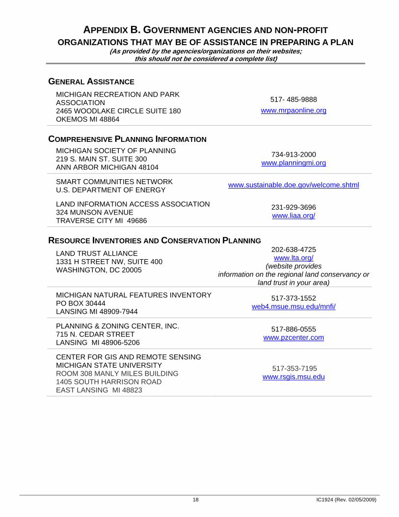
APPENDIX B. GOVERNMENT AGENCIES AND NON-PROFIT ORGANIZATIONS THAT MAY BE OF ASSISTANCE IN PREPARING A PLAN
(As provided by the agencies/organizations on their websites; this should not be considered a complete list)
GENERAL ASSISTANCE MICHIGAN RECREATION AND PARK
ASSOCIATION 2465 WOODLAKE CIRCLE SUITE 180 OKEMOS MI 48864
517- 485-9888 www.mrpaonline.org
COMPREHENSIVE PLANNING INFORMATION MICHIGAN SOCIETY OF PLANNING
219 S. MAIN ST. SUITE 300 ANN ARBOR MICHIGAN 48104
734-913-2000 www.planningmi.org
SMART COMMUNITIES NETWORK U.S. DEPARTMENT OF ENERGY
www.sustainable.doe.gov/welcome.shtml
LAND INFORMATION ACCESS ASSOCIATION 324 MUNSON AVENUE TRAVERSE CITY MI 49686
231-929-3696 www.liaa.org/
RESOURCE INVENTORIES AND CONSERVATION PLANNING LAND TRUST ALLIANCE
1331 H STREET NW, SUITE 400 WASHINGTON, DC 20005
202-638-4725 www.lta.org/
(website provides information on the regional land conservancy or
land trust in your area) MICHIGAN NATURAL FEATURES INVENTORY
PO BOX 30444 LANSING MI 48909-7944
517-373-1552 web4.msue.msu.edu/mnfi/
PLANNING & ZONING CENTER, INC. 715 N. CEDAR STREET LANSING MI 48906-5206
517-886-0555 www.pzcenter.com
CENTER FOR GIS AND REMOTE SENSING MICHIGAN STATE UNIVERSITY ROOM 308 MANLY MILES BUILDING 1405 SOUTH HARRISON ROAD EAST LANSING MI 48823
517-353-7195 www.rsgis.msu.edu
19 IC1924 (Rev. 02/05/2009)
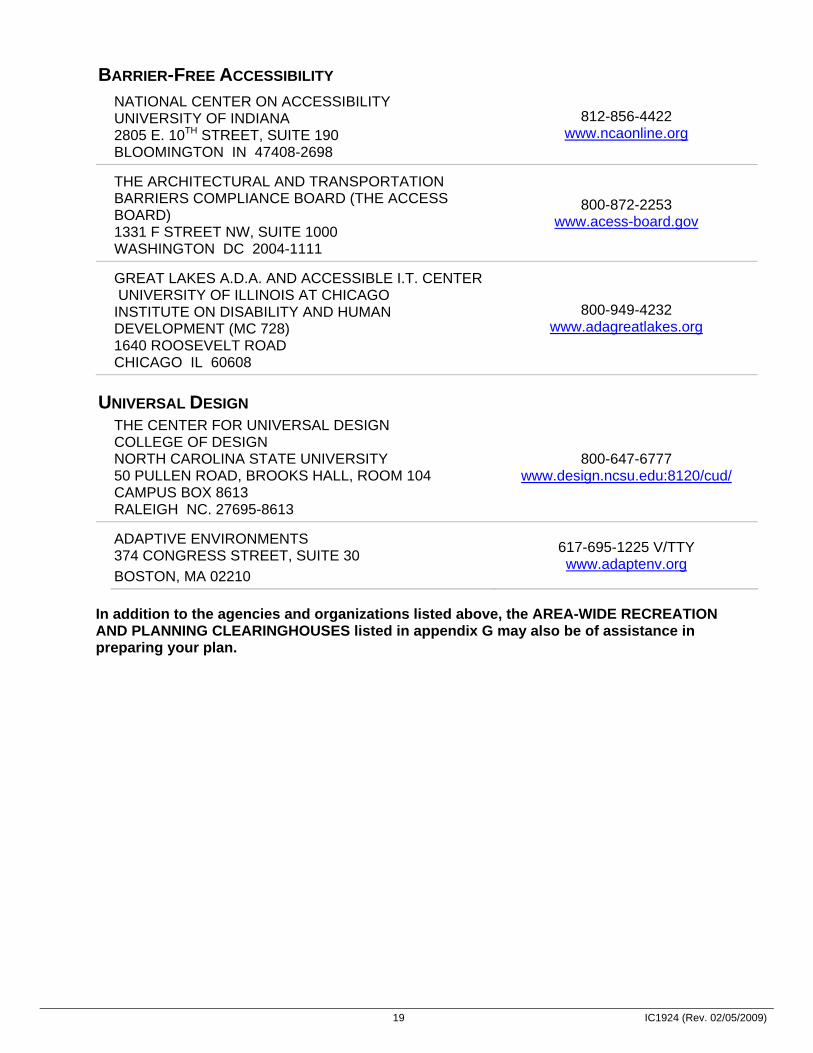
BARRIER-FREE ACCESSIBILITY NATIONAL CENTER ON ACCESSIBILITY
UNIVERSITY OF INDIANA 2805 E. 10TH STREET, SUITE 190 BLOOMINGTON IN 47408-2698
812-856-4422 www.ncaonline.org
THE ARCHITECTURAL AND TRANSPORTATION BARRIERS COMPLIANCE BOARD (THE ACCESS BOARD) 1331 F STREET NW, SUITE 1000 WASHINGTON DC 2004-1111
800-872-2253 www.acess-board.gov
GREAT LAKES A.D.A. AND ACCESSIBLE I.T. CENTER UNIVERSITY OF ILLINOIS AT CHICAGO INSTITUTE ON DISABILITY AND HUMAN DEVELOPMENT (MC 728) 1640 ROOSEVELT ROAD CHICAGO IL 60608
800-949-4232 www.adagreatlakes.org
UNIVERSAL DESIGN THE CENTER FOR UNIVERSAL DESIGN
COLLEGE OF DESIGN NORTH CAROLINA STATE UNIVERSITY 50 PULLEN ROAD, BROOKS HALL, ROOM 104 CAMPUS BOX 8613 RALEIGH NC. 27695-8613
800-647-6777 www.design.ncsu.edu:8120/cud/
ADAPTIVE ENVIRONMENTS 374 CONGRESS STREET, SUITE 30 BOSTON, MA 02210
617-695-1225 V/TTY www.adaptenv.org
In addition to the agencies and organizations listed above, the AREA-WIDE RECREATION AND PLANNING CLEARINGHOUSES listed in appendix G may also be of assistance in preparing your plan.

20 IC1924 (Rev. 02/05/2009)
APPENDIX C. A RECOMMENDED CLASSIFICATION SYSTEM FOR LOCAL AND REGIONAL RECREATION OPEN SPACE AND TRAILS
Classification General Description Location Criteria Size Criteria Mini-Park Used to address limited, isolated or unique recreational
needs. Less than ¼ mile distance in residential setting.
Between 2500 sq. ft. and one acre in size.
Neighborhood Park
Neighborhood park remains the basic unit of the park system and serves as the recreational and social focus of the neighborhood. Focus is on informal active and passive recreation.
¼- to ½-mile distance and uninterrupted by non-residential roads and other physical barriers.
5 acres is considered minimum size. 5 to 10 acres is optimal.
School-Park Depending on circumstances, combining parks with school sites can fulfill the space requirements for other classes of parks, such as neighborhood, community, sports complex and special use.
Determined by location of school district property.
Variable-depends on function.
Community Park
Serves broader purpose than neighborhood park. Focus is on meeting community-based recreation needs, as well as preserving unique landscapes and open spaces.
Determined by the quality and suitability of the site. Usually serves two or more neighborhoods and ½ to 3 mile distance.
As needed to accommodate desired uses. Usually between 30 and 50 acres.
Large Urban Park
Large urban parks serve a broader purpose than community parks and are used when community and neighborhood parks are not adequate to serve the needs of the community. Focus is on meeting community-based recreational needs, as well as preserving unique landscapes and open spaces.
Determined by the quality and suitability of the site. Usually serves the entire community.
As needed to accommodate desired uses. Usually a minimum of 50 acres, with 75 or more acres being optimal.
Natural Resource Areas
Lands set aside for preservation of significant natural resources, remnant landscapes, open space, and visual aesthetics/buffering.
Resource availability and opportunity.
Variable.
Greenways Effectively tie park system components together to form a continuous park environment.
Resource availability and opportunity.
Variable.
Sports Complex
Consolidates heavily programmed athletic fields and associated facilities to larger and fewer sites strategically located throughout the community.
Strategically located community-wide facilities.
Determined by projected demand. Usually a minimum of 25 acres, with 40 to 80 acres being optimal.
Special Use Covers a broad range of parks and recreation facilities oriented toward single- purpose use.
Variable-dependent on specific use. Variable.

21 IC1924 (Rev. 02/05/2009)
APPENDIX C. (continued)
Classification General Description Location Criteria Size Criteria Private Park/ Recreation Facility
Parks and recreation facilities that are privately owned yet contribute to the public park and recreation system.
Variable-dependent on specific use. Variable.
Classification General Description Description of each type Park Trail Multipurpose trails located within greenways, parks
and natural resource areas. Focus is on recreational value and harmony with natural environment.
• Type I: Separate/single-purpose hard-surfaced trails for pedestrians or bicyclists / in-line skaters.
• Type II: Multipurpose hard-surfaced trails for pedestrians and bicyclists/in-line skaters.
• Type III: Nature trails for pedestrians. May be hard- or soft-surfaced.
Connector Trails Multipurpose trails that emphasize safe travel for pedestrians to and from parks and around the community. Focus is as much on transportation as it is on recreation.
• Type I: Separate/single-purpose hard-surfaced trails for pedestrians or bicyclists / in-line skaters located in independent r.o.w. (e.g., old railroad r.o.w.).
• Type II: Separate/single-purpose hard-surfaced trails for pedestrians or bicyclists/in-line skaters. Typically located within road r.o.w.
On-Street Bikeways
Paved segments of roadways that serve as a means to safely separate bicyclists from vehicular traffic.
Bike Route: Designated portions of the roadway for the preferential or exclusive use of bicyclists. Bike Lane: Shared portions of the roadway that provide separation between motor vehicles and bicyclists, such as paved shoulders.
All-Terrain Bike Trail
Off-road trail for all-terrain (mountain) bikes. Single-purpose loop trails usually located in larger parks and natural resource areas.
Cross-Country Ski Trail
Trails developed for traditional and skate-style cross-country skiing.
Loop trails usually located in larger parks and natural resource areas.
Equestrian Trail Trails developed for horseback riding. Loop trails usually located in larger parks and natural resource areas. Sometimes developed as multipurpose with hiking and all-terrain biking where conflicts can be controlled.
Adapted From: Lancaster, R. A., Ed. Recreation, Park and Open Space Standards and Guidelines. Alexandria, VA: National Recreation and Park Association, 1983. Mertes, J. D. and J. R. Hall. Park, Recreation, Open Space and Greenway Guidelines. Alexandria, VA: National Recreation and Park Association, 1995.
22 IC1924 (Rev. 02/05/2009)
APPENDIX D. BARRIER FREE ACCESSIBILITY REQUIREMENTS FOR PARKS Recreational areas, facilities, and programs play an important role in the life of the community; therefore it is essential that people with disabilities have an equal opportunity to enjoy these areas and any programs provided. Federal and state laws prohibit discrimination on the basis of disability, and these laws apply to parks and other recreation lands and programs controlled and operated by local units of government. The DNR has a strong commitment to barrier free recreational opportunities in our Department-managed programs and facilities. This commitment extends to those communities that receive recreation grants.
Under the state Utilization of Public Facilities by the Physically Limited Act (1966 PA 1, as amended) all public facilities, including improved areas used for recreation, must meet the barrier free design requirements contained in the state construction code. Under this act, the administration and enforcement related to barrier free design requirements are vested in the local or state government agency responsible for issuing a building permit. If the project does not require a building permit, administration and enforcement of barrier free design requirements are vested in the Department of Labor and Economic Growth.
Any request for an exception to the barrier free design requirements of the state construction code must be submitted to the Barrier Free Design Board, within the Department of Labor and Economic Growth (517-241-9300). The Barrier Free Design Board has the responsibility to receive, review, and process requests for exceptions to barrier free design specifications; require appropriate equivalent alternatives when exceptions are granted; and receive, process, and make recommendations for barrier free design rules.
Because the state construction code does not apply to many recreation facilities, it is essential that you also be aware of and understand the existing federal guidelines covering these types of facilities. In July 2004, the federal Architectural and Transportation Barriers Compliance Board (known as the Access Board) issued updated guidelines, entitled the Americans with Disabilities Act Accessibility Guidelines (ADAAG), for new or altered facilities covered by the Americans with Disabilities Act of 1990 (Public Law 101-336) or the Architectural Barriers Act of 1968 (Public Law 90-480). These guidelines should eventually be adopted as enforceable standards. Until that occurs, the existing ADAAG standards must be followed when the two conflict.
Included in the updated ADAAG are technical provisions for a number of types of recreation facilities, including play areas, amusement rides, boating facilities, fishing piers and platforms, golf courses, miniature golf courses, shooting facilities, swimming and wading pools, and spas. Technical provisions for these recreation facilities do not exist in the current AADAG. The Access Board has also proposed guidelines for sports facilities, trails, beaches, and picnic and camping areas. While none of these guidelines has yet been adopted as federal standards, they represent the best information available on developing barrier free recreation facilities and may be upheld in a court of law. Therefore, they should be referred to when designing new or renovated recreation facilities.
A list of public agencies and organizations that can assist you with questions regarding barrier free accessibility and universal design is provided in appendix B.

23 IC1924 (Rev. 02/05/2009)
APPENDIX E. SUGGESTED FACILITY DEVELOPMENT STANDARDS
ACTIVITY/ FACILITY
RECOMMENDED SPACE
REQUIREMENTS
RECOMMENDED SIZE AND
DIMENSIONS
RECOMMENDED ORIENTATION
NO. OF UNITS PER
POPULATION
SERVICE RADIUS
LOCATION NOTES
BADMINTON 1620 sq. ft. Singles - 17' x 44' Doubles - 20' x 44' with 5' unobstructed area on all sides.
Long axis north-south. 1 per 5000 ¼ - ½ mile Usually in school, recreation center or church facility. Safe walking or biking access.
BASKETBALL 1. YOUTH 2. HIGH SCHOOL 3. COLLEGIATE
2400-3036 sq. ft. 5040-7280 sq. ft. 5600-7980 sq. ft.
46'-50' x 84' 50' x 84' 50' x 94' with 5' unobstructed space an all sides.
Long axis north-south. 1 per 5000 ¼ - ½ mile Same as badminton. Outdoor courts in neighborhood and community parks, plus active recreation areas in other park settings.
HANDBALL (3-4 WALL)
800 sq. ft. for 4-wall. 1000 for 3-wall
20' x 40' - Minimum of 10' to rear of 3-wall court. Minimum 20' overhead clearance.
Long axis north-south. Front wall at north end.
1 per 20,000 15-30 minute travel time
4-wall usually indoor as part of multi-purpose facility. 3-wall usually outdoor in park or school setting.
ICE HOCKEY 22,000 sq. ft. including support area.
Rink 85' x 200' (minimum 85' X 185'. Additional 5000 sq. ft. support area).
Long axis north-south if outdoors.
Indoor- 1 per 100,000.
Outdoor- depends on climate
½ - 1 hour travel time
Climate important consideration affecting number of units. Best as part of multi-purpose facility.
TENNIS Minimum of 7,200 sq. ft. single court. (2 acres for complex.)
36' x 78'. 12' clearance on both sides; 21' clearance on both ends.
Long axis north-south. 1 court per 2000
¼ - ½ mile Best in batteries of 2-4. Located in neighborhood/ community park or near school site.
VOLLEYBALL Minimum of 4,000 sq. ft.
30' x 60'. Minimum 6' clearance on all sides.
Long axis north-south. 1 court per 5000
½ - 1 mile Same as other court activities (e.g., badminton, basketball, etc.).
BASEBALL 1. OFFICIAL
2. LITTLE LEAGUE
3.0-3.85 A minimum
1.2 A minimum
• Baselines-90' Pitching distance-60.5' Foul lines-min. 320' Center field-400'+
• Baselines-60' Pitching distance-46' Foul lines-200' Center field-200' - 250'
Locate home plate so pitcher throwing across sun and batter not facing it. Line from home plate through pitcher's mound to run east-northeast.
1 per 5000 Lighted- 1 per 30,000
¼ - ½ mile Part of neighborhood complex. Lighted fields part of community complex.

24 IC1924 (Rev. 02/05/2009)
ACTIVITY/ FACILITY
RECOMMENDED SPACE
REQUIREMENTS
RECOMMENDED SIZE AND
DIMENSIONS
RECOMMENDED ORIENTATION
NO. OF UNITS PER
POPULATION
SERVICE RADIUS
LOCATION NOTES
FIELD HOCKEY Minimum 1.5A 180' x 300' with a minimum of 10' clearance an all sides.
Fall season-long axis northwest to southeast. For longer periods, north to south.
1 per 20,000 15-30 minutes travel time
Usually part of baseball, football, or soccer complex in community park or adjacent to high school.
FOOTBALL Minimum 1.5A 160' x 360' with a minimum of 6' clearance on all sides.
Same as field hockey. 1 per 20,000 15-30 minutes travel time
Same as field hockey.
SOCCER 1.7 to 2.1A 195' to 225' x 330' to 360' with a 10' minimum clearance on all sides.
Same as field hockey. 1 per 10,000 1-2 miles Number of units depends on popularity. Youth soccer on smaller fields adjacent to schools or neighborhood parks.
GOLF-DRIVING RANGE
13.5A for minimum of 25 tees
900' x 690' wide. Add 12' width for each additional tee.
Long axis southwest/ northeast with golfer driving toward northeast.
1 per 50,000 30 minutes travel time
Part of golf course complex as a separate unit. May be privately operated.
1/4-MILE RUNNING TRACK
4.3A Overall width-276' length-600' Track width for 8 to 4 lanes is 32'.
Long axis in sector from north to south to northwest/southeast with finish line at northerly end.
1 per 20,000 15-30 minutes travel time
Usually part of high school or community park complex in combination with football, soccer, etc.
SOFTBALL 1.5 to 2.0A Baselines-60' Pitching distance-45' (men) - 40' (women).
Fast pitch field radius from plate-225' between foul lines.
Slow pitch-275' (men) - 250' (women).
Same as baseball. 1 per 5,000 (if also used for youth baseball)
¼- to ½- mile Slight difference in dimensions for 16" slow pitch. May also be used for youth baseball.
MULTIPLE RECREATION COURT (BASKETBALL, VOLLEYBALL, TENNIS)
9,840 sq. ft. 120' x 80' Long axis of courts with primary use north-south.
1 per 10,000 1-2 miles In neighborhood or community parks.
TRAILS N/A Well defined head. Capacity- Rural trails 40 hikers/day/ mile. Urban trails-90 hikers/ day/mile.
N/A 1 system per region
N/A

25 IC1924 (Rev. 02/05/2009)
ACTIVITY/ FACILITY
RECOMMENDED SPACE
REQUIREMENTS
RECOMMENDED SIZE AND
DIMENSIONS
RECOMMENDED ORIENTATION
NO. OF UNITS PER
POPULATION
SERVICE RADIUS
LOCATION NOTES
ARCHERY RANGE Minimum 0.65A 300' length x minimum 10' between targets. Roped clear space on sides of range. Minimum of 30' clear space behind targets. Minimum of 90' x 45' with bunker.
Archer facing north + or - 45 degrees.
1 per 50,000 30 minutes travel time
Part of a regional/ metro park complex.
COMBINATION SKEET AND TRAP FIELD (8 STATION)
Minimum 30A All walks and structures occur within an area approximately 130' wide by 115' deep. Minimum cleared area is contained within two superimposed segments with 100-yard radii (4 acres). Shot-fall danger zone is contained within two superimposed segments with 300-yard radii (36 acres).
Center line of length runs northeast/southwest with shooter facing northeast.
1 per 50,000 30 minutes travel time
Part of a regional/ metro park complex.
GOLF 1. PAR 3 (18-
HOLE) 2. 9-HOLE
STANDARD 3. 18-HOLE
STANDARD
• 50-60A • Minimum 50A • Minimum 110A
• Average length varies- 600-2700 yards • Average length 2250 yards • Average length 6500 yards
Majority of holes on north-south axis.
• - - • 1/25,000 • 1/50,000
1/2 to 1 hour travel time
9-hole course can accommodate 350 people/day. 18-hole course can accommodate 500-550 people a day. Course may be located in community, district, or regional/metro park.
SWIMMING POOLS Varies on size of pool and amenities. Usually 1 to 2A site.
Teaching-minimum of 25 yards x 45' even depth of 3 to 4 feet. Competitive-minimum of 25m x 16m. Minimum of 27 square feet of water surface per swimmer. Ratio of 2:1 deck vs. water.
None-although care must be taken in siting of lifeguard stations in relation to afternoon sun
1 per 20,000 Pools should accommodate 3% to 5% of the total population at a time.)
15 to 30 minutes travel time
Pools for general community use should be planned for teaching, competitive, and recreational purposes with enough depth to accommodate 1m and 3m diving boards. Located in community park or school site.
BEACH AREAS N/A Beach area should have 50 sq. ft. of land and 50 sq. ft. of water per user. Turnover rate is 3. There should be 3-4A supporting land per A of beach.
N/A N/A ½ to 1 hour travel time
Should have sand bottom with slope a maximum of 5% (flat preferable). Boating areas completely segregated from swimming areas. In regional/metro parks.
Adapted From: Lancaster, R. A., Ed. Recreation, Park and Open Space Standards and Guidelines. Alexandria, VA: National Recreation and Park Association, 1983. Mertes, J. D. and J. R. Hall. Park, Recreation, Open Space and Greenway Guidelines. Alexandria, VA: National Recreation and Park Association, 1995.
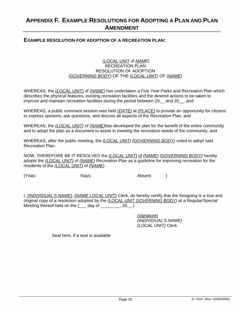
Page 26 IC 1924 (Rev. 02/05/2009)
APPENDIX F. EXAMPLE RESOLUTIONS FOR ADOPTING A PLAN AND PLAN AMENDMENT
EXAMPLE RESOLUTION FOR ADOPTION OF A RECREATION PLAN:
(LOCAL UNIT of NAME) RECREATION PLAN
RESOLUTION OF ADOPTION (GOVERNING BODY) OF THE (LOCAL UNIT) OF (NAME)
WHEREAS, the (LOCAL UNIT) of (NAME) has undertaken a Five Year Parks and Recreation Plan which describes the physical features, existing recreation facilities and the desired actions to be taken to improve and maintain recreation facilities during the period between 20__ and 20__, and WHEREAS, a public comment session was held (DATE) at (PLACE) to provide an opportunity for citizens to express opinions, ask questions, and discuss all aspects of the Recreation Plan, and WHEREAS, the (LOCAL UNIT) of (NAME)has developed the plan for the benefit of the entire community and to adopt the plan as a document to assist in meeting the recreation needs of the community, and WHEREAS, after the public meeting, the (LOCAL UNIT) (GOVERNING BODY) voted to adopt said Recreation Plan. NOW, THEREFORE BE IT RESOLVED the (LOCAL UNIT) of (NAME) (GOVERNING BODY) hereby adopts the (LOCAL UNIT) of (NAME) Recreation Plan as a guideline for improving recreation for the residents of the (LOCAL UNIT) of (NAME). (Yeas: Nays: Absent: ) I, (INDIVIDUAL’S NAME), (NAME LOCAL UNIT) Clerk, do hereby certify that the foregoing is a true and original copy of a resolution adopted by the (LOCAL UNIT GOVERNING BODY) at a Regular/Special Meeting thereof held on the (___ day of ________, 20__.)
(signature) (INDIVIDUAL’S NAME) (LOCAL UNIT) Clerk Seal here, if a seal is available

Page 27 IC 1924 (Rev. 02/05/2009)
EXAMPLE RESOLUTION FOR ADOPTION OF A RECREATION PLAN AMENDMENT:
(LOCAL UNIT of NAME) RECREATION PLAN AMENDMENT
RESOLUTION OF ADOPTION (GOVERNING BODY) OF THE (LOCAL UNIT) OF (NAME)
WHEREAS, the (LOCAL UNIT) of (NAME) has undertaken a Parks and Recreation Plan Amendment which describes changes to the Five Year Parks and Recreation Plan originally adopted in (YEAR) and indicates actions to be taken to improve and maintain recreation facilities during the same five year period, and WHEREAS, a public comment session was held (DATE) at (PLACE) to provide an opportunity for citizens to express opinions, ask questions, and discuss all aspects of the Recreation Plan Amendment, and WHEREAS, after the public meeting, the (LOCAL UNIT) (GOVERNING BODY) voted to adopt said Recreation Plan Amendment. NOW, THEREFORE BE IT RESOLVED the (LOCAL UNIT) of (NAME) (GOVERNING BODY) hereby adopts the (LOCAL UNIT) of (NAME) Recreation Plan Amendment. (Yeas: Nays: Absent: ) I, (INDIVIDUAL’S NAME), (NAME LOCAL UNIT) Clerk, do hereby certify that the foregoing is a true and original copy of a resolution adopted by the (LOCAL UNIT) (GOVERNING BODY) at a Regular/Special Meeting thereof held on the (___ day of ________, 20__.) (signature) (INDIVIDUAL’S NAME) (LOCAL UNIT) Clerk Seal here, if a seal is available
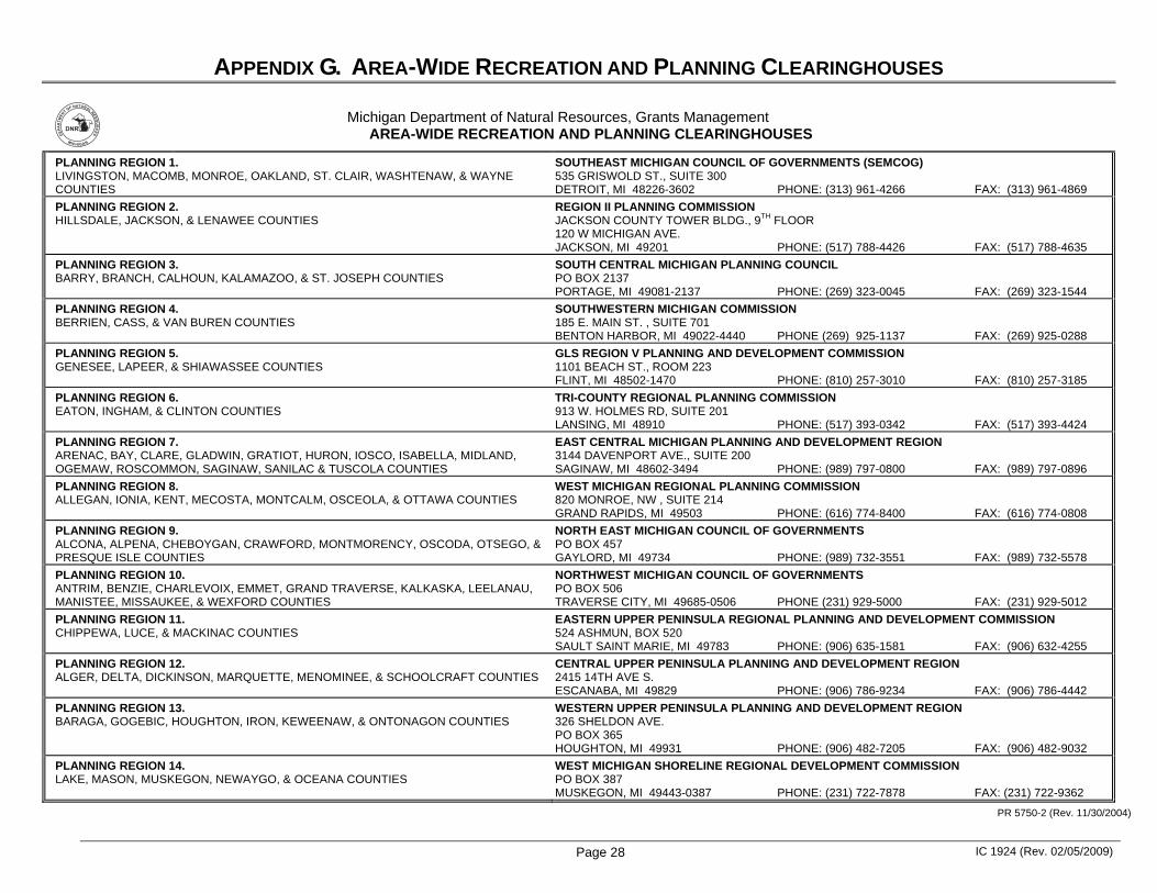
Page 28 IC 1924 (Rev. 02/05/2009)
APPENDIX G. AREA-WIDE RECREATION AND PLANNING CLEARINGHOUSES
������
���
� ������
��������
�������
���
Michigan Department of Natural Resources, Grants Management AREA-WIDE RECREATION AND PLANNING CLEARINGHOUSES
PLANNING REGION 1. LIVINGSTON, MACOMB, MONROE, OAKLAND, ST. CLAIR, WASHTENAW, & WAYNE COUNTIES
SOUTHEAST MICHIGAN COUNCIL OF GOVERNMENTS (SEMCOG) 535 GRISWOLD ST., SUITE 300 DETROIT, MI 48226-3602 PHONE: (313) 961-4266 FAX: (313) 961-4869
PLANNING REGION 2. HILLSDALE, JACKSON, & LENAWEE COUNTIES
REGION II PLANNING COMMISSION JACKSON COUNTY TOWER BLDG., 9TH FLOOR 120 W MICHIGAN AVE. JACKSON, MI 49201 PHONE: (517) 788-4426 FAX: (517) 788-4635
PLANNING REGION 3. BARRY, BRANCH, CALHOUN, KALAMAZOO, & ST. JOSEPH COUNTIES
SOUTH CENTRAL MICHIGAN PLANNING COUNCIL PO BOX 2137 PORTAGE, MI 49081-2137 PHONE: (269) 323-0045 FAX: (269) 323-1544
PLANNING REGION 4. BERRIEN, CASS, & VAN BUREN COUNTIES
SOUTHWESTERN MICHIGAN COMMISSION 185 E. MAIN ST. , SUITE 701 BENTON HARBOR, MI 49022-4440 PHONE (269) 925-1137 FAX: (269) 925-0288
PLANNING REGION 5. GENESEE, LAPEER, & SHIAWASSEE COUNTIES
GLS REGION V PLANNING AND DEVELOPMENT COMMISSION 1101 BEACH ST., ROOM 223 FLINT, MI 48502-1470 PHONE: (810) 257-3010 FAX: (810) 257-3185
PLANNING REGION 6. EATON, INGHAM, & CLINTON COUNTIES
TRI-COUNTY REGIONAL PLANNING COMMISSION 913 W. HOLMES RD, SUITE 201 LANSING, MI 48910 PHONE: (517) 393-0342 FAX: (517) 393-4424
PLANNING REGION 7. ARENAC, BAY, CLARE, GLADWIN, GRATIOT, HURON, IOSCO, ISABELLA, MIDLAND, OGEMAW, ROSCOMMON, SAGINAW, SANILAC & TUSCOLA COUNTIES
EAST CENTRAL MICHIGAN PLANNING AND DEVELOPMENT REGION 3144 DAVENPORT AVE., SUITE 200 SAGINAW, MI 48602-3494 PHONE: (989) 797-0800 FAX: (989) 797-0896
PLANNING REGION 8. ALLEGAN, IONIA, KENT, MECOSTA, MONTCALM, OSCEOLA, & OTTAWA COUNTIES
WEST MICHIGAN REGIONAL PLANNING COMMISSION 820 MONROE, NW , SUITE 214 GRAND RAPIDS, MI 49503 PHONE: (616) 774-8400 FAX: (616) 774-0808
PLANNING REGION 9. ALCONA, ALPENA, CHEBOYGAN, CRAWFORD, MONTMORENCY, OSCODA, OTSEGO, & PRESQUE ISLE COUNTIES
NORTH EAST MICHIGAN COUNCIL OF GOVERNMENTS PO BOX 457 GAYLORD, MI 49734 PHONE: (989) 732-3551 FAX: (989) 732-5578
PLANNING REGION 10. ANTRIM, BENZIE, CHARLEVOIX, EMMET, GRAND TRAVERSE, KALKASKA, LEELANAU, MANISTEE, MISSAUKEE, & WEXFORD COUNTIES
NORTHWEST MICHIGAN COUNCIL OF GOVERNMENTS PO BOX 506 TRAVERSE CITY, MI 49685-0506 PHONE (231) 929-5000 FAX: (231) 929-5012
PLANNING REGION 11. CHIPPEWA, LUCE, & MACKINAC COUNTIES
EASTERN UPPER PENINSULA REGIONAL PLANNING AND DEVELOPMENT COMMISSION 524 ASHMUN, BOX 520 SAULT SAINT MARIE, MI 49783 PHONE: (906) 635-1581 FAX: (906) 632-4255
PLANNING REGION 12. ALGER, DELTA, DICKINSON, MARQUETTE, MENOMINEE, & SCHOOLCRAFT COUNTIES
CENTRAL UPPER PENINSULA PLANNING AND DEVELOPMENT REGION 2415 14TH AVE S. ESCANABA, MI 49829 PHONE: (906) 786-9234 FAX: (906) 786-4442
PLANNING REGION 13. BARAGA, GOGEBIC, HOUGHTON, IRON, KEWEENAW, & ONTONAGON COUNTIES
WESTERN UPPER PENINSULA PLANNING AND DEVELOPMENT REGION 326 SHELDON AVE. PO BOX 365 HOUGHTON, MI 49931 PHONE: (906) 482-7205 FAX: (906) 482-9032
PLANNING REGION 14. LAKE, MASON, MUSKEGON, NEWAYGO, & OCEANA COUNTIES
WEST MICHIGAN SHORELINE REGIONAL DEVELOPMENT COMMISSION PO BOX 387 MUSKEGON, MI 49443-0387 PHONE: (231) 722-7878 FAX: (231) 722-9362
PR 5750-2 (Rev. 11/30/2004)

Page 29 IC 1924 (Rev. 02/05/2009)
APPENDIX H. COMMUNITY PARK, RECREATION, OPEN SPACE AND GREENWAY PLAN CERTIFICATION CHECKLIST
Michigan Department of Natural Resources-Grants Management
COMMUNITY PARK, RECREATION, OPEN SPACE, AND GREENWAY PLAN CERTIFICATION CHECKLIST
By Authority of Parts 19, 703 and 716 of Act 451, P.A. 1994, as amended, submission of this information is required for eligibility to apply for grants
INSTRUCTIONS: Complete, obtain certification signatures and submit this checklist with a locally adopted recreation plan.
All recreation plans are required to meet the content and local approval standards listed in this checklist and as outlined in the Guidelines for the Development of Community Park, Recreation, Open Space and Greenway Plans provided by the Michigan Department of Natural Resources (DNR). To be eligible for grant consideration, plans must be submitted to the DNR prior to the grant application deadline with a completed checklist that has been signed by an authorized official(s) of the local unit of government(s) submitting the plan.
PLAN INFORMATION Name of Plan:
List the community names (including school districts) covered by the plan County Month and year plan adopted by the
community’s governing body
PLAN CONTENT
INSTRUCTIONS: Please check each box to certify that the listed information is included in the final plan.
1. COMMUNITY DESCRIPTION
2. ADMINISTRATIVE STRUCTURE
Roles of Commission(s) or Advisory Board(s) Department, Authority and/or Staff Description and Organizational Chart
Annual and Projected Budgets for Operations, Maintenance, Capital Improvements and Recreation Programming
Current Funding Sources Role of Volunteers Relationship(s) with School Districts, Other Public Agencies or Private Organizations Regional Authorities or Trailway Commissions Only
Description of the Relationship between the Authority or Commission and the Recreation Departments of Participating Communities
Articles of Incorporation
3. RECREATION INVENTORY
Description of Methods Used to Conduct the Inventory Inventory of all Community Owned Parks and Recreation Facilities Location Maps (site development plans recommended but not required) Accessibility Assessment Status Report for all Grant-Assisted Parks and Recreation Facilities
4. RESOURCE INVENTORY (OPTIONAL)
5. DESCRIPTION OF THE PLANNING PROCESS

Page 30 IC 1924 (Rev. 02/05/2009)
6. DESCRIPTION OF THE PUBLIC INPUT PROCESS Description of the Method(s) Used to Solicit Public Input Before or During Preparation of the Plan, Including a
Copy of the Survey or Meeting Agenda and a Summary of the Responses Received Copy of the Notice of the Availability of the Draft Plan for Public Review and Comment
Date of the Notice
Type of Notice
Plan Location
Duration of Draft Plan Public Review Period (Must be at Least 30 Days) Copy of the Notice for the Public Meeting Held after the One Month Public Review Period and Before the
Plan’s Adoption by the Governing Body(ies) Date of Notice Name of Newspaper Date of Meeting Copy of the Minutes from the Public Meeting
7. GOALS AND OBJECTIVES
8. ACTION PROGRAM
PLAN ADOPTION DOCUMENTATION
Plans must be adopted by the highest level governing body (i.e., city council, county commission, township board). If planning is the responsibility of a Planning Commission, Park and Recreation Commission, Recreation Advisory Board or other local Board or Commission, the plan should also include a resolution from the Board or Commission recommending adoption of the plan by the governing body. The local unit of government must submit the final plan to both the County and Regional Planning Agency for their information. Documentation that this was done must be submitted with the plan to the DNR. Items 1, 3 and 4 below are required and must be included in the plan. APPROVAL DOCUMENTATION: For multi-jurisdictional plans, each local unit of government must pass a resolution adopting the plan. Prepare and attach a separate page for each unit of government included in the plan.
1. Official resolution of adoption by the governing body dated:
2. Official resolution of the
Commission or Board,
recommending adoption of the plan by the governing body, dated:
3. Copy of letter transmitting adopted plan to County Planning Agency dated:
4. Copy of letter transmitting adopted plan to Regional Planning Agency dated:
OVERALL CERTIFICATION NOTE: For multi-jurisdictional plans, Overall Certification must include the signature of each local unit of government.
Prepare and attach a separate signature page for each unit of government included in the plan. I hereby certify that the recreation plan for
includes the required content, as indicated (Local Unit of Government) above and as set forth by the DNR. Authorized Official for the Local Unit of Government Date
DNR USE ONLY - APPROVAL The recreation plan is approved by the DNR and the community (ies) covered by the plan, as listed on page 1 of this checklist is/are eligible to apply for recreation grants through
Date By:
This completed checklist must be signed and submitted with a locally adopted recreation plan to:
GRANTS MANAGEMENT MICHIGAN DEPARTMENT OF NATURAL RESOURCES PO BOX 30425 LANSING, MI 48909-7925
Grants Management Date

Page 31 IC 1924 (Rev. 02/05/2009)
APPENDIX I. COMMUNITY PARK, RECREATION, OPEN SPACE AND GREENWAY PLAN AMENDMENT CERTIFICATION CHECKLIST
Michigan Department of Natural Resources-Grants Management
COMMUNITY PARK, RECREATION, OPEN SPACE, AND GREENWAY PLAN CERTIFICATION CHECKLIST
AMENDMENT By Authority of Parts 19, 703 and 716 of Act 451, P.A. 1994, as amended, submission of this
information is required for eligibility to apply for grants
INSTRUCTIONS: Complete, obtain certification signatures and submit this checklist with a locally adopted recreation plan amendment.
All community recreation plan amendments are required to meet the content and local approval standards listed in this checklist and as outlined in the Guidelines for the Development of Community Park, Recreation, Open Space and Greenway Plans provided by the Department of Natural Resources (DNR). To be eligible for grant consideration, plan amendments must be submitted to the DNR prior to the grant application deadline with a completed checklist that has been signed by an authorized official(s) of the local unit of government(s) submitting the plan.
PLAN AMENDMENT FORMAT Plan amendments must consist of either:
1.) A complete, revised plan with a letter of explanation that indicates what aspects of the original plan have been revised and how; or
2.) Revised or additional pages to the approved recreation plan, with an explanation of where the new pages fit within the original plan. If the amendment is to be inserted into the existing plan, it must be similar in format to the approved plan and indicate the location for insertion.
Name of Plan: Date Current Plan Expires:
List the community names (including school districts) covered by the plan County Month and year plan adopted by the
community’s governing body
PLAN AMENDMENT ELEMENT INSTRUCTIONS: Please check each box to certify that the listed information is included in the plan amendment submittal.
DESCRIPTION OF THE PLANNING PROCESS
DESCRIPTION OF THE PUBLIC INPUT PROCESS Description of the Method(s) Used to Solicit Public Input Before or During Preparation of the Plan, Including a
Copy of the Survey or Meeting Agenda and a Summary of the Responses Received Copy of the Notice of the Availability of the Draft Plan for Public Review and Comment Date of the Notice
Type of Notice Plan Location
Duration of Draft Plan Public Review Period (Must be at Least Two Weeks)
Copy of the Notice for the Public Meeting Held after the Two-Week Public Review Period and Before the Plan’s Adoption by the Governing Body(ies)
Date of Notice
Name of Newspaper
Date of Meeting
Copy of the Minutes from the Public Meeting

Page 32 IC 1924 (Rev. 02/05/2009)
AMENDED GOALS AND OBJECTIVES
OTHER ELEMENTS: If the plan amendment includes other updated plan elements, list and briefly describe. PLAN AMENDMENT ELEMENT
1.
2.
3.
PLAN AMENDMENT ADOPTION DOCUMENTATION
Plans must be adopted by the highest level governing body (i.e., city council, county commission, township board). If planning is the responsibility of a Planning Commission, Park and Recreation Commission, Recreation Advisory Board or other local Board or Commission, the plan should also include a resolution from the Board or Commission recommending adoption of the plan by the governing body. The local unit of government must submit the final plan to both the County and Regional Planning Agency for their information. Documentation that this was done must be submitted with the plan to the DNR. Items 1, 3 and 4 below are required and must be included in the plan. APPROVAL DOCUMENTATION: For multi-jurisdictional plans, each local unit of government must pass a resolution adopting the plan. Prepare and attach a separate page for each unit of government included in the plan.
5. Official resolution of adoption by the governing body dated:
6. Official resolution of the
Commission or Board,
recommending adoption of the plan by the governing body, dated:
7. Copy of letter transmitting adopted plan to County Planning Agency dated:
8. Copy of letter transmitting adopted plan to Regional Planning Agency dated:
OVERALL CERTIFICATION NOTE: For multi-jurisdictional plans, Overall Certification must include the signature of each local unit of government.
Prepare and attach a separate signature page for each unit of government included in the plan. I hereby certify that the recreation plan for
includes the required content, as indicated (Local Unit of Government) above and as set forth by the DNR. Authorized Official for the Local Unit of Government Date
DNR USE ONLY - APPROVAL
The recreation plan is approved by the DNR and the community (ies) covered by the plan, as listed on page 1 of this checklist is/are eligible to apply for recreation grants through
Date
By:
This completed checklist must be signed and submitted with a locally adopted recreation plan to:
GRANTS MANAGEMENT MICHIGAN DEPARTMENT OF NATURAL RESOURCES PO BOX 30425 LANSING, MI 48909-7925
Grants Management Date