Embed Size (px)
Citation preview
GX TECHNOLOGY | Data Processing, Imaging and Reservoir Services
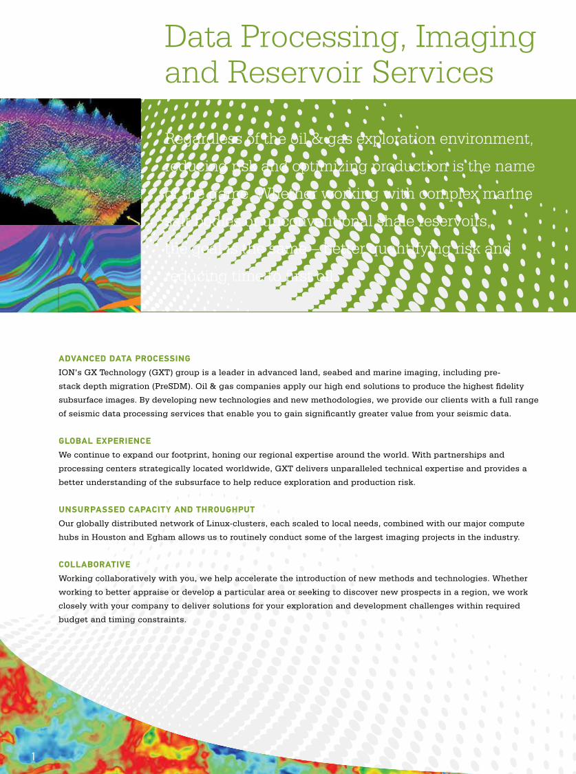
Regardless of the oil & gas exploration environment,
reducing risk and optimizing production is the name
of the game. Whether working with complex marine
salt bodies or unconventional shale reservoirs,
the goal is the same – better quantifying risk and
reducing time to first oil.
ADVANCED DATA PROCESSING ION’s GX Technology (GXT) group is a leader in advanced land, seabed and marine imaging, including pre-
stack depth migration (PreSDM). Oil & gas companies apply our high end solutions to produce the highest fidelity
subsurface images. By developing new technologies and new methodologies, we provide our clients with a full range
of seismic data processing services that enable you to gain significantly greater value from your seismic data.
GLOBAL EXPERIENCE We continue to expand our footprint, honing our regional expertise around the world. With partnerships and
processing centers strategically located worldwide, GXT delivers unparalleled technical expertise and provides a
better understanding of the subsurface to help reduce exploration and production risk.
UNSURPASSED CAPACITY AND THROUGHPUTOur globally distributed network of Linux-clusters, each scaled to local needs, combined with our major compute
hubs in Houston and Egham allows us to routinely conduct some of the largest imaging projects in the industry.
COLLABORATIVEWorking collaboratively with you, we help accelerate the introduction of new methods and technologies. Whether
working to better appraise or develop a particular area or seeking to discover new prospects in a region, we work
closely with your company to deliver solutions for your exploration and development challenges within required
budget and timing constraints.
Data Processing, Imaging and Reservoir Services
1
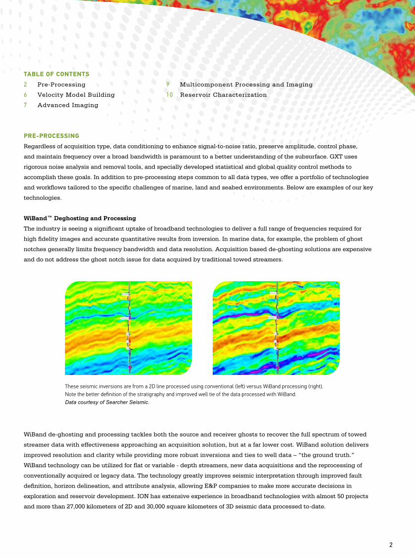
TABLE OF CONTENTS
2 Pre-Processing 9 Multicomponent Processing and Imaging
6 Velocity Model Building 10 Reservoir Characterization
7 Advanced Imaging
PRE-PROCESSING
Regardless of acquisition type, data conditioning to enhance signal-to-noise ratio, preserve amplitude, control phase,
and maintain frequency over a broad bandwidth is paramount to a better understanding of the subsurface. GXT uses
rigorous noise analysis and removal tools, and specially developed statistical and global quality control methods to
accomplish these goals. In addition to pre-processing steps common to all data types, we offer a portfolio of technologies
and workflows tailored to the specific challenges of marine, land and seabed environments. Below are examples of our key
technologies.
WiBand™ Deghosting and Processing
The industry is seeing a significant uptake of broadband technologies to deliver a full range of frequencies required for
high fidelity images and accurate quantitative results from inversion. In marine data, for example, the problem of ghost
notches generally limits frequency bandwidth and data resolution. Acquisition based de-ghosting solutions are expensive
and do not address the ghost notch issue for data acquired by traditional towed streamers.
WiBand de-ghosting and processing tackles both the source and receiver ghosts to recover the full spectrum of towed
streamer data with effectiveness approaching an acquisition solution, but at a far lower cost. WiBand solution delivers
improved resolution and clarity while providing more robust inversions and ties to well data – “the ground truth.”
WiBand technology can be utilized for flat or variable - depth streamers, new data acquisitions and the reprocessing of
conventionally acquired or legacy data. The technology greatly improves seismic interpretation through improved fault
definition, horizon delineation, and attribute analysis, allowing E&P companies to make more accurate decisions in
exploration and reservoir development. ION has extensive experience in broadband technologies with almost 50 projects
and more than 27,000 kilometers of 2D and 30,000 square kilometers of 3D seismic data processed to-date.
Data Processing, Imaging and Reservoir Services
These seismic inversions are from a 2D line processed using conventional (left) versus WiBand processing (right). Note the better definition of the stratigraphy and improved well tie of the data processed with WiBand.Data courtesy of Searcher Seismic.
2
Data Processing, Imaging and Reservoir Services
Noise Attenuation
Depending on the acquisition type, a broad range of noise types must be attenuated to preserve primary signal.
Recorded data can be contaminated by coherent or random noise. Marine noise sources include, but are not limited
to, seismic acquisition vessels, shipping lanes, platform infrastructure, strumming from the vessel, cables and buoys,
surface waves, and swell noise. Land noise sources may include ground roll and air blast, coherent road and drill rig
noise as well as cultural noise. For seabed acquisition, unique noise conditions that should be attenuated include
Sholte waves, shear wave leakage, swell noise in shallow water, strum and others. Our core noise removal algorithm,
SWDNOISE, is a frequency dependent, data adaptive method capable of attenuating noise bursts, spikes and swell
noise. For organized noise, GXT offers effective radial filter tools and has extensive modeling experience in the fk, fkk,
and tau-p domains followed by adaptive matching and subtraction.
Surface Related Multiple Elimination (3D SRME)
Surface Related Multiple Elimination (3D SRME) is a model-based multiple suppression method that is fully data driven,
and the only input needed is the data to be modeled. The user need not identify the multiple generating interfaces. It
works well in both moderately shallow and deep-water marine environments; in addition, our 3D SRME toolkit is fully
applicable to both WAZ and NAZ datasets. GXT pioneered 3D SRME in 2005 and has extensive experience processing
tens of thousands of square kilometers.
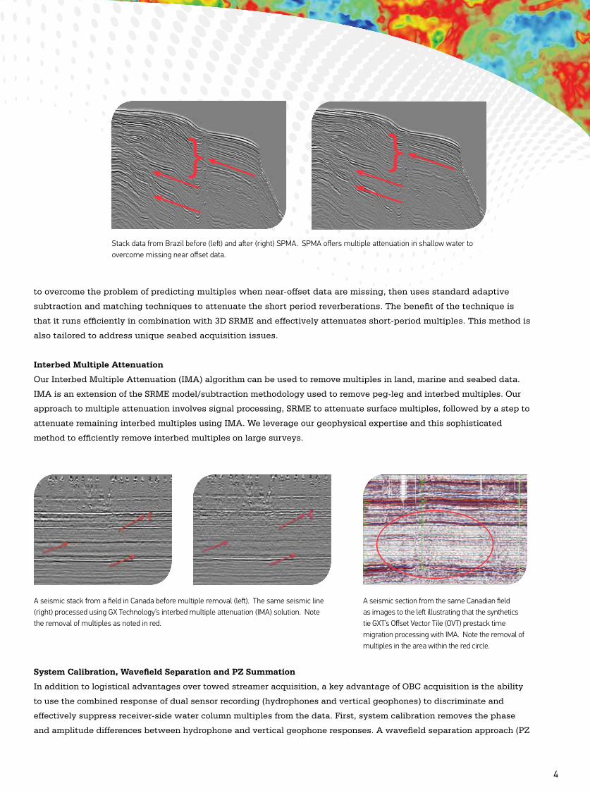
Short Period Multiple Attenuation (SPMA)
Data acquisition in shallow water introduces noise in the form of short-period multiples that may not be effectively
removed using traditional 3D SRME technologies. GXT employs a proprietary Short Period Multiple Attenuation
(SPMA) technique, in combination with 3D SRME to remove this type of noise. This method uses pre-stack migration
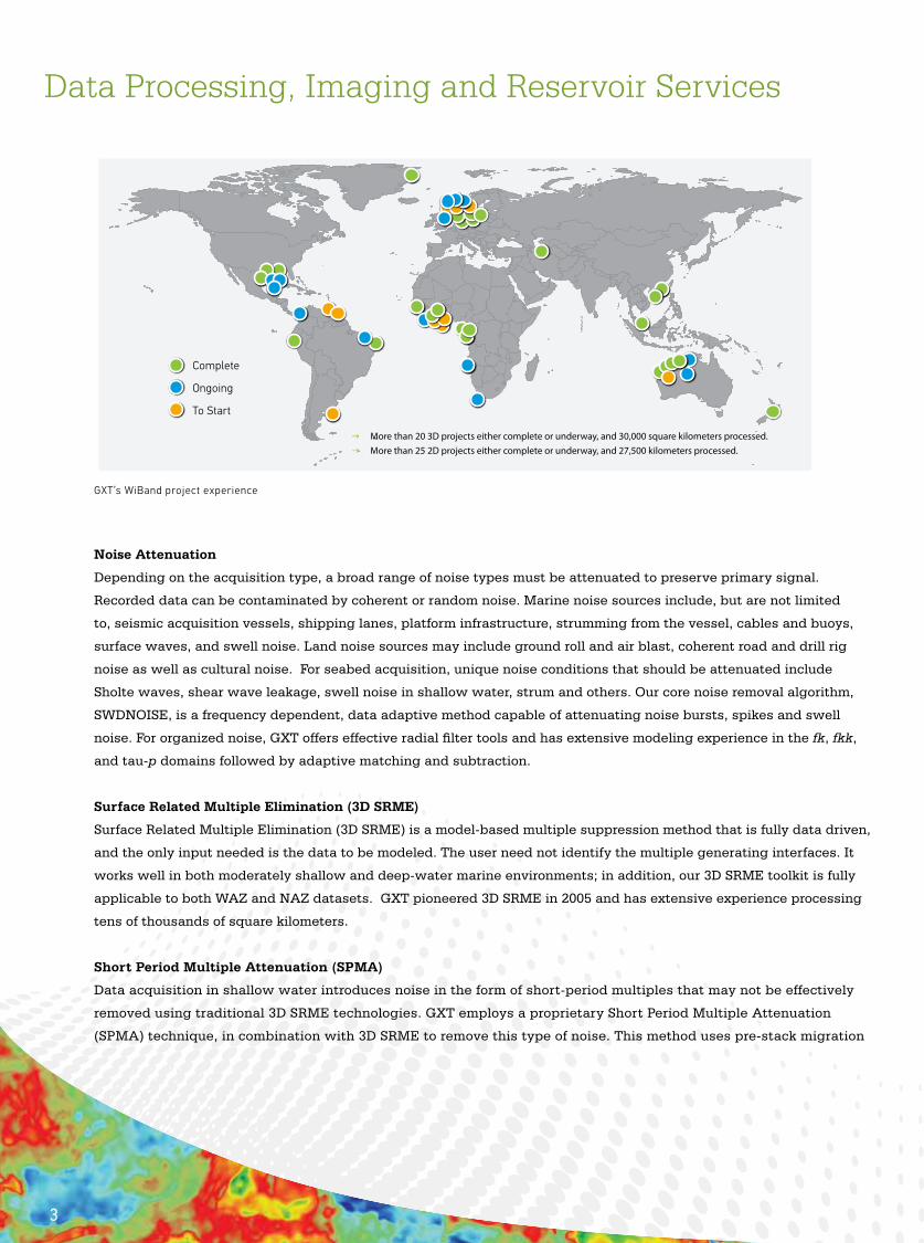
Complete
Ongoing
To Start
→ More than 20 3D projects either complete or underway, and 30,000 square kilometers processed.→ More than 25 2D projects either complete or underway, and 27,500 kilometers processed.
GXT’s WiBand project experience
3
Data Processing, Imaging and Reservoir Services
to overcome the problem of predicting multiples when near-offset data are missing, then uses standard adaptive
subtraction and matching techniques to attenuate the short period reverberations. The benefit of the technique is
that it runs efficiently in combination with 3D SRME and effectively attenuates short-period multiples. This method is
also tailored to address unique seabed acquisition issues.
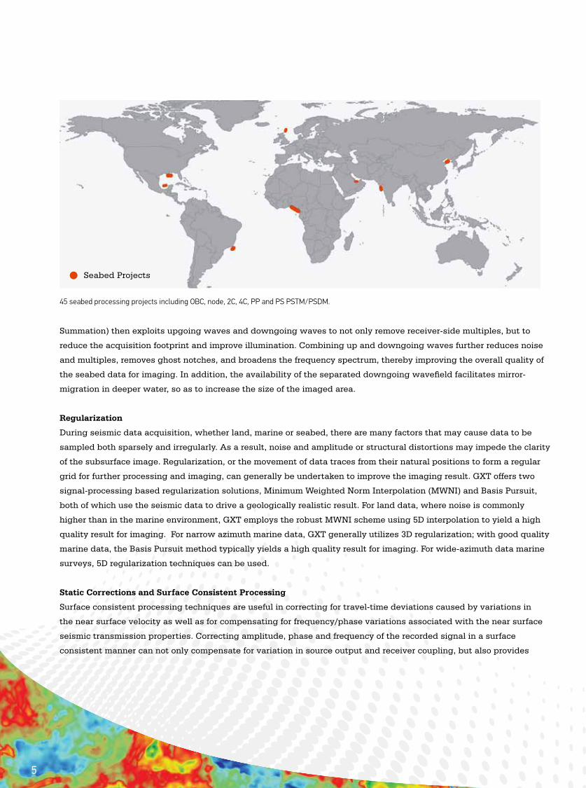
Interbed Multiple Attenuation
Our Interbed Multiple Attenuation (IMA) algorithm can be used to remove multiples in land, marine and seabed data.
IMA is an extension of the SRME model/subtraction methodology used to remove peg-leg and interbed multiples. Our
approach to multiple attenuation involves signal processing, SRME to attenuate surface multiples, followed by a step to
attenuate remaining interbed multiples using IMA. We leverage our geophysical expertise and this sophisticated
method to efficiently remove interbed multiples on large surveys.
System Calibration, Wavefield Separation and PZ Summation
In addition to logistical advantages over towed streamer acquisition, a key advantage of OBC acquisition is the ability
to use the combined response of dual sensor recording (hydrophones and vertical geophones) to discriminate and
effectively suppress receiver-side water column multiples from the data. First, system calibration removes the phase
and amplitude differences between hydrophone and vertical geophone responses. A wavefield separation approach (PZ
Stack data from Brazil before (left) and after (right) SPMA. SPMA offers multiple attenuation in shallow water to overcome missing near offset data.
A seismic stack from a field in Canada before multiple removal (left). The same seismic line (right) processed using GX Technology’s interbed multiple attenuation (IMA) solution. Note the removal of multiples as noted in red.
A seismic section from the same Canadian field as images to the left illustrating that the synthetics tie GXT’s Offset Vector Tile (OVT) prestack time migration processing with IMA. Note the removal of multiples in the area within the red circle.
4
Summation) then exploits upgoing waves and downgoing waves to not only remove receiver-side multiples, but to
reduce the acquisition footprint and improve illumination. Combining up and downgoing waves further reduces noise
and multiples, removes ghost notches, and broadens the frequency spectrum, thereby improving the overall quality of
the seabed data for imaging. In addition, the availability of the separated downgoing wavefield facilitates mirror-
migration in deeper water, so as to increase the size of the imaged area.
Regularization
During seismic data acquisition, whether land, marine or seabed, there are many factors that may cause data to be
sampled both sparsely and irregularly. As a result, noise and amplitude or structural distortions may impede the clarity
of the subsurface image. Regularization, or the movement of data traces from their natural positions to form a regular
grid for further processing and imaging, can generally be undertaken to improve the imaging result. GXT offers two
signal-processing based regularization solutions, Minimum Weighted Norm Interpolation (MWNI) and Basis Pursuit,
both of which use the seismic data to drive a geologically realistic result. For land data, where noise is commonly
higher than in the marine environment, GXT employs the robust MWNI scheme using 5D interpolation to yield a high
quality result for imaging. For narrow azimuth marine data, GXT generally utilizes 3D regularization; with good quality
marine data, the Basis Pursuit method typically yields a high quality result for imaging. For wide-azimuth data marine
surveys, 5D regularization techniques can be used.
Static Corrections and Surface Consistent Processing
Surface consistent processing techniques are useful in correcting for travel-time deviations caused by variations in
the near surface velocity as well as for compensating for frequency/phase variations associated with the near surface
seismic transmission properties. Correcting amplitude, phase and frequency of the recorded signal in a surface
consistent manner can not only compensate for variation in source output and receiver coupling, but also provides
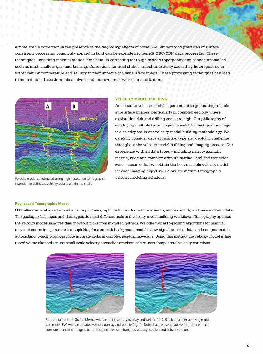
Seabed Projects
45 seabed processing projects including OBC, node, 2C, 4C, PP and PS PSTM/PSDM.
5
a more stable correction in the presence of the degrading effects of noise. Well-understood practices of surface
consistent processing commonly applied in land can be extended to benefit OBC/OBN data processing. These
techniques, including residual statics, are useful in correcting for rough seabed topography and seabed anomalies
such as mud, shallow gas, and faulting. Corrections for tidal statics, travel-time delay caused by heterogeneity in
water column temperature and salinity further improve the subsurface image. These processing techniques can lead
to more detailed stratigraphic analysis and improved reservoir characterization.
VELOCITY MODEL BUILDING
An accurate velocity model is paramount to generating reliable
subsurface images, particularly in complex geology where
exploration risk and drilling costs are high. Our philosophy of
employing multiple technologies to yield the best quality image
is also adopted in our velocity model building methodology. We
carefully consider data acquisition type and geologic challenge
throughout the velocity model building and imaging process. Our
experience with all data types – including narrow azimuth
marine, wide and complex azimuth marine, land and transition
zone – assures that we obtain the best possible velocity model
for each imaging objective. Below are mature tomographic
velocity modeling solutions.
Ray-based Tomographic Model
GXT offers several isotropic and anisotropic tomographic solutions for narrow azimuth, multi-azimuth, and wide-azimuth data.
The geologic challenges and data types demand different tools and velocity model building workflows. Tomography updates
the velocity model using residual moveout picks from migrated gathers. We offer two auto-picking algorithms for residual
moveout correction; parametric autopicking for a smooth background model in low signal-to-noise data, and non-parametric
autopicking, which produces more accurate picks in complex residual moveouts. Using this method the velocity model is fine
tuned where channels cause small-scale velocity anomalies or where salt causes sharp lateral velocity variations.
Velocity model constructed using high-resolution tomographic inversion to delineate velocity details within the chalk.
6
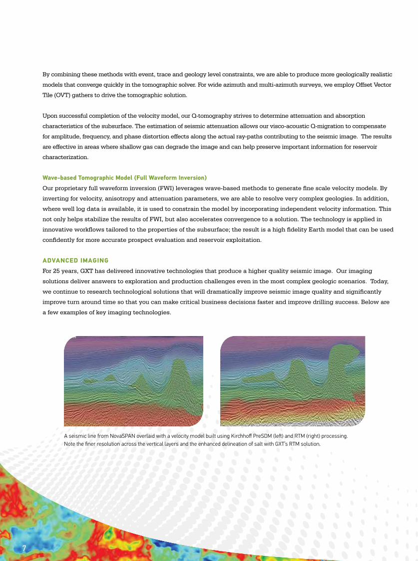
Stack data from the Gulf of Mexico with an initial velocity overlay and well tie (left). Stack data after applying multi-parameter FWI with an updated velocity overlay and well tie (right). Note shallow events above the salt are more consistent, and the image is better focused after simultaneous velocity, epsilon and delta inversion.
By combining these methods with event, trace and geology level constraints, we are able to produce more geologically realistic
models that converge quickly in the tomographic solver. For wide azimuth and multi-azimuth surveys, we employ Offset Vector
Tile (OVT) gathers to drive the tomographic solution.
Upon successful completion of the velocity model, our Q-tomography strives to determine attenuation and absorption
characteristics of the subsurface. The estimation of seismic attenuation allows our visco-acoustic Q-migration to compensate
for amplitude, frequency, and phase distortion effects along the actual ray-paths contributing to the seismic image. The results
are effective in areas where shallow gas can degrade the image and can help preserve important information for reservoir
characterization.
Wave-based Tomographic Model (Full Waveform Inversion)
Our proprietary full waveform inversion (FWI) leverages wave-based methods to generate fine scale velocity models. By
inverting for velocity, anisotropy and attenuation parameters, we are able to resolve very complex geologies. In addition,
where well log data is available, it is used to constrain the model by incorporating independent velocity information. This
not only helps stabilize the results of FWI, but also accelerates convergence to a solution. The technology is applied in
innovative workflows tailored to the properties of the subsurface; the result is a high fidelity Earth model that can be used
confidently for more accurate prospect evaluation and reservoir exploitation.
ADVANCED IMAGING
For 25 years, GXT has delivered innovative technologies that produce a higher quality seismic image. Our imaging
solutions deliver answers to exploration and production challenges even in the most complex geologic scenarios. Today,
we continue to research technological solutions that will dramatically improve seismic image quality and significantly
improve turn around time so that you can make critical business decisions faster and improve drilling success. Below are
a few examples of key imaging technologies.
A seismic line from NovaSPAN overlaid with a velocity model built using Kirchhoff PreSDM (left) and RTM (right) processing. Note the finer resolution across the vertical layers and the enhanced delineation of salt with GXT’s RTM solution.
7
Reverse Time Migration
Reverse Time Migration (RTM) is the purest form of PreSDM wavefield-extrapolation migration. Unlike PreSDM methods,
such as Kirchhoff or Beam migration, RTM handles complexities of the wavefront and does not impose a one-way energy
propagation assumption that can potentially yield misleading images of complex geobodies like salt diapirs. In complex
velocity regimes, RTM is a powerful tool for imaging steep dips, overturned reflectors and the salt face while preserving
amplitude and phase information. RTM is the algorithm of choice in complex salt provinces. We are known for our
pioneering work in the field of RTM and have amassed experience from more than 100 projects and 180,000 kilometers
of seismic data. We use proprietary RTM-based methodologies to efficiently process 2D or 3D, wide azimuth (WAZ)
and complex acquisition datasets. The result leads to an improved understanding of subsalt structure where many
hydrocarbon reservoirs are found.
RTM3
E&P companies need more efficient methods to image complex data, particularly in salt provinces, while reducing cycle
time. In the past, modifying the velocity model to test different salt body scenarios was not feasible because of the time
required to iterate through the model building and imaging process. Our RTM3 suite delivers remote data access and
intuitive 3D model morphing tools to modify salt model features securely from your office so that you can quickly play
out “what if” scenarios. We eliminate data exchanges and extend RTM imaging capabilities to allow interpretation and
model building to occur at the same time. Streamlined model building and processing workflows leverage the speed and
full aperture benefits of reverse time migration. The process of iteratively interpreting horizons, building velocity models,
migration, and QC can be reduced from months to weeks.
Kirchhoff PreSDM/PreSTM
Kirchhoff pre-stack depth migration (PreSDM) utilizes turning ray techniques to image steep dips and overhangs even
where anisotropic conditions exist. Additionally, our Kirchhoff PreSDM algorithm is amplitude preserving, making it the
ideal choice for AVO studies. Our Kirchhoff methods are highly efficient and optimized for specific hardware so we are able
to employ a “no compromise” approach when selecting migration parameters. The result is a quality and cost effective
subsurface image in less time than RTM or wave equation methods. Where the subsurface geology and velocity field is
moderately complex our Kirchhoff Pre-stack Time Migration (PreSTM) is the logical choice. In addition to well-established
acoustic migration schemes, we also offer a visco-acoustic Kirchhoff migration where attenuation effects are accounted for
during the imaging process.
Beam Migration
Beam migration is particularly suited for imaging steep or overturned events where rapid turn-around time is a key
concern. In challenging regimes, such as sub-salt or sub-basalt, Beam migration techniques have the advantage
over Kirchhoff migration by handling multi-path arrivals. In this scenario, Beam migrations produce a cleaner
image by accounting for multi-arrival events which are critical for resolving difficult to image events. By computing
operators only in the vicinity of a narrow trajectory, migration speed can be tuned and costs can be kept in check. Our
implementations of 2D and 3D Beam migration are tailored to output common-image gathers for use in tomography
iterations and offer the flexibility to output inline or cross-line targeted images. Beam migration is suitable for land,
OBC, marine, NAZ, and WAZ data acquisition.
8
Anisotropic Imaging
Anisotropy effects are present in seismic data from most basins in the world. Unless properly analyzed and modeled,
anisotropic effects can degrade the seismic image and derived attributes. In the case of horizontal transverse isotropy
(HTI) caused by vertically aligned fractures or unequal horizontal stress, we offer AZIM™ technology to measure
azimuthal velocity anisotropy. This proprietary approach takes HTI and vertical transverse isotropy (VTI) effects into
account. The result is an azimuthally-varying NMO function that improves the stacked image. Additionally, the process
provides information about stress fields and fracture networks that drive critical drilling decisions in unconventional
resource plays. Where orthogonal fractures are superimposed on layered anisotropic behavior, we offer an orthorhombic
solution.
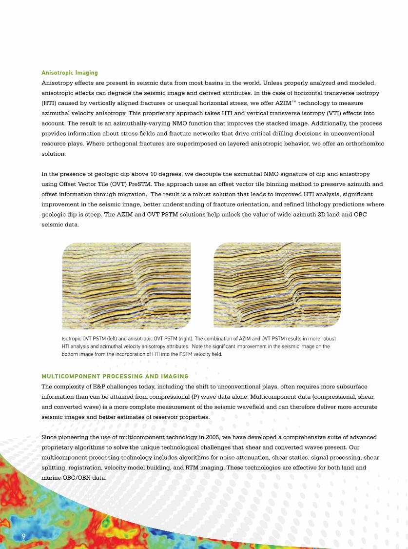
In the presence of geologic dip above 10 degrees, we decouple the azimuthal NMO signature of dip and anisotropy
using Offset Vector Tile (OVT) PreSTM. The approach uses an offset vector tile binning method to preserve azimuth and
offset information through migration. The result is a robust solution that leads to improved HTI analysis, significant
improvement in the seismic image, better understanding of fracture orientation, and refined lithology predictions where
geologic dip is steep. The AZIM and OVT PSTM solutions help unlock the value of wide azimuth 3D land and OBC
seismic data.
MULTICOMPONENT PROCESSING AND IMAGING
The complexity of E&P challenges today, including the shift to unconventional plays, often requires more subsurface
information than can be attained from compressional (P) wave data alone. Multicomponent data (compressional, shear,
and converted wave) is a more complete measurement of the seismic wavefield and can therefore deliver more accurate
seismic images and better estimates of reservoir properties.
Since pioneering the use of multicomponent technology in 2005, we have developed a comprehensive suite of advanced
proprietary algorithms to solve the unique technological challenges that shear and converted waves present. Our
multicomponent processing technology includes algorithms for noise attenuation, shear statics, signal processing, shear
splitting, registration, velocity model building, and RTM imaging. These technologies are effective for both land and
marine OBC/OBN data.
Isotropic OVT PSTM (left) and anisotropic OVT PSTM (right). The combination of AZIM and OVT PSTM results in more robust HTI analysis and azimuthal velocity anisotropy attributes. Note the significant improvement in the seismic image on the bottom image from the incorporation of HTI into the PSTM velocity field.
9
GXT experts skillfully use multicomponent data to resolve a broad range of challenges from seismic imaging to
reservoir characterization and development. The data can be used to enhance the seismic image through gas
clouds, confirm hydrocarbon bright spots, or identify drilling hazards by modeling the presence of shallow gas and
over-pressure zones. Processing and inversion of PP and PS data can provide more accurate prediction of favorable
reservoir properties. Additionally, measurements of shear and converted wave anisotropy can provide useful
information about reservoir fracture density and orientation.
RESERVOIR CHARACTERIZATION
The GXT Reservoir Services team provides advanced analysis, modeling, and interpretation services to help E&P
companies meet reserves replacement and production targets cost effectively. We are a leader in integrating
geophysical, geological, petrophysical, and rock physics technologies to deliver a more complete picture of your
reservoirs. From prospect identification and ranking, to reservoir appraisal, to field development, to production
monitoring, we customize services to help you manage uncertainty, reduce risk, and decrease project cycle time.
The majority of our Reservoir Services team has 25 years of experience on staff at E&P companies around the globe.
We work closely with your team to help maximize return on investment.
Examples of our capabilities that can help you better understand the reservoir are described below.
Geological Interpretation
Our comprehensive portfolio of geological services goes beyond traditional log editing and well correlation, facies
interpretation, cross section and mapping tasks to provide deep insight into all aspects of oil and gas exploration and
development. Whether your project requires expertise in basin scale petroleum geology, regional stratigraphy and
sedimentology, complex structural interpretation, or reservoir scale detail, our geoscientists are equipped with the
technology and knowledge to assist. Our geologic capabilities are integrated with other disciplines and technologies
to assure a more complete description of the reservoir.
10
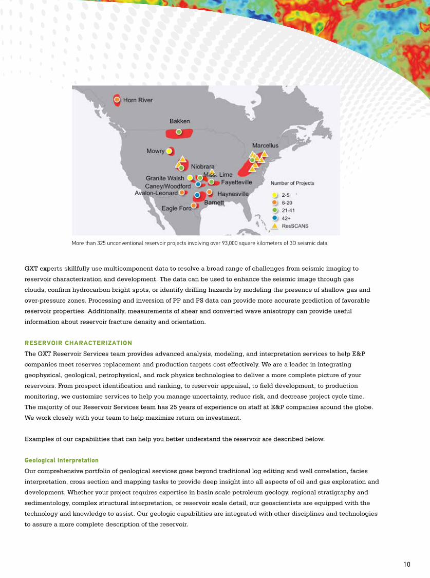
More than 325 unconventional reservoir projects involving over 93,000 square kilometers of 3D seismic data.
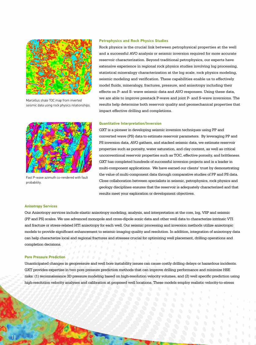
Petrophysics and Rock Physics Studies
Rock physics is the crucial link between petrophysical properties at the well
and a successful AVO analysis or seismic inversion required for more accurate
reservoir characterization. Beyond traditional petrophysics, our experts have
extensive experience in regional rock physics studies involving log processing,
statistical mineralogy characterization at the log scale, rock physics modeling,
seismic modeling and verification. These capabilities enable us to effectively
model fluids, mineralogy, fractures, pressure, and anisotropy including their
effects on P- and S- wave seismic data and AVO responses. Using these data,
we are able to improve prestack P-wave and joint P- and S-wave inversions. The
results help determine both reservoir quality and geomechanical properties that
impact effective drilling and completions.
Quantitative Interpretation/Inversion
GXT is a pioneer in developing seismic inversion techniques using PP and
converted wave (PS) data to estimate reservoir parameters. By leveraging PP and
PS inversion data, AVO gathers, and stacked seismic data, we estimate reservoir
properties such as porosity, water saturation, and clay content, as well as critical
unconventional reservoir properties such as TOC, effective porosity, and brittleness.
GXT has completed hundreds of successful inversion projects and is a leader in
multi-component applications. We have earned our clients’ trust by demonstrating
the value of multi-component data through comparative studies of PP and PS data.
Close collaboration between specialists in seismic, petrophysics, rock physics and
geology disciplines ensures that the reservoir is adequately characterized and that
results meet your exploration or development objectives.
Anisotropy Services
Our Anisotropy services include elastic anisotropy modeling, analysis, and interpretation at the core, log, VSP and seismic
(PP and PS) scales. We use advanced monopole and cross-dipole sonic data and other well data to characterize intrinsic VTI
and fracture or stress-related HTI anisotropy for each well. Our seismic processing and inversion methods utilize anisotropic
models to provide significant enhancement to seismic imaging quality and resolution. In addition, integration of anisotropy data
can help characterize local and regional fractures and stresses crucial for optimizing well placement, drilling operations and
completion decisions.
Pore Pressure Prediction
Unanticipated changes in geopressure and well bore instability issues can cause costly drilling delays or hazardous incidents.
GXT provides expertise in two pore pressure prediction methods that can improve drilling performance and minimize HSE
risks: (1) reconnaissance 3D pressure modeling based on high-resolution velocity volumes, and (2) well specific prediction using
high-resolution velocity analyses and calibration at proposed well locations. These models employ realistic velocity-to-stress
Marcellus shale TOC map from inverted seismic data using rock physics relationships.
Fast P-wave azimuth co-rendered with fault probability.
11
relationships based on a shale compaction/diagenesis rock physics model. This approach has proven to be significantly more
accurate than using empirical relationships that fail beyond certain depths. In addition to predicting geopressures prior to
drilling, we also offer services to update the pore pressure/fracture gradient model in near real time while the well is drilling.
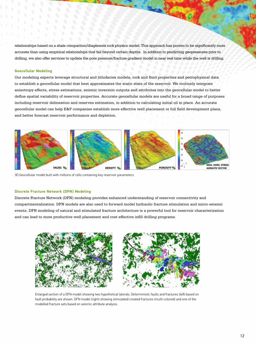
Geocellular Modeling
Our modeling experts leverage structural and lithofacies models, rock and fluid properties and petrophysical data
to establish a geocellular model that best approximates the static state of the reservoir. We routinely integrate
anisotropy effects, stress estimations, seismic inversion outputs and attributes into the geocellular model to better
define spatial variability of reservoir properties. Accurate geocellular models are useful for a broad range of purposes
including reservoir delineation and reserves estimation, in addition to calculating initial oil in place. An accurate
geocellular model can help E&P companies establish more effective well placement or full field development plans,
and better forecast reservoir performance and depletion.
Discrete Fracture Network (DFN) Modeling
Discrete Fracture Network (DFN) modeling provides enhanced understanding of reservoir connectivity and
compartmentalization. DFN models are also used to forward model hydraulic fracture stimulation and micro-seismic
events. DFN modeling of natural and stimulated fracture architecture is a powerful tool for reservoir characterization
and can lead to more productive well placement and cost effective infill drilling programs.
3D Geocellular model built with millions of cells containing key reservoir parameters.
12
Enlarged section of a DFN model showing two hypothetical laterals. Deterministic faults and fractures (left) based on fault probability are shown. DFN model (right) showing stimulated/created fractures (multi-colored) and one of the modelled fracture sets based on seismic attribute analysis.
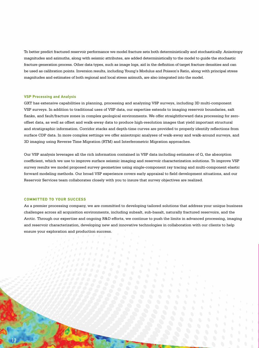
To better predict fractured reservoir performance we model fracture sets both deterministically and stochastically. Anisotropy
magnitudes and azimuths, along with seismic attributes, are added deterministically to the model to guide the stochastic
fracture generation process. Other data types, such as image logs, aid in the definition of target fracture densities and can
be used as calibration points. Inversion results, including Young’s Modulus and Poisson’s Ratio, along with principal stress
magnitudes and estimates of both regional and local stress azimuth, are also integrated into the model.
VSP Processing and Analysis
GXT has extensive capabilities in planning, processing and analyzing VSP surveys, including 3D multi-component
VSP surveys. In addition to traditional uses of VSP data, our expertise extends to imaging reservoir boundaries, salt
flanks, and fault/fracture zones in complex geological environments. We offer straightforward data processing for zero-
offset data, as well as offset and walk-away data to produce high-resolution images that yield important structural
and stratigraphic information. Corridor stacks and depth-time curves are provided to properly identify reflections from
surface CDP data. In more complex settings we offer anisotropic analyses of walk-away and walk-around surveys, and
3D imaging using Reverse Time Migration (RTM) and Interferometric Migration approaches.
Our VSP analysis leverages all the rich information contained in VSP data including estimates of Q, the absorption
coefficient, which we use to improve surface seismic imaging and reservoir characterization solutions. To improve VSP
survey results we model proposed survey geometries using single-component ray tracing and multi-component elastic
forward modeling methods. Our broad VSP experience covers early appraisal to field development situations, and our
Reservoir Services team collaborates closely with you to insure that survey objectives are realized.
COMMITTED TO YOUR SUCCESS
As a premier processing company, we are committed to developing tailored solutions that address your unique business
challenges across all acquisition environments, including subsalt, sub-basalt, naturally fractured reservoirs, and the
Arctic. Through our expertise and ongoing R&D efforts, we continue to push the limits in advanced processing, imaging
and reservoir characterization, developing new and innovative technologies in collaboration with our clients to help
ensure your exploration and production success.
13
→ Charged to innovate. Driven to solve.
ION Geophysical Corporation is a leading provider
of geophysical technology, services, and solutions
for the global oil & gas industry. ION’s offerings are
designed to allow E&P operators to obtain higher
resolution images of the subsurface to reduce the
risk of exploration and reservoir development, and
to enable seismic contractors to acquire geophysical
data safely and efficiently.
PRINTER TO BUILD POCKET DIECUT TO CAPACITY FOR FOLD-IN
GX TECHNOLOGY
To learn more about how ION helps oil & gas companies and seismic contractors solve their toughest imaging and operational challenges, visit us at iongeo.com
ION Geophysical CorporationGX Technology2105 CityWest Blvd., Suite 900Houston, TX 77042 USAPhone +1 713 789 7250Fax +1 713 789 7201
05/2014PROCESSING CENTERS: HOUSTON, DENVER, OKLAHOMA CITY, CALGARY, RIO DE JANEIRO,
PORT OF SPAIN, LONDON, CAIRO, PORT HARCOURT, LUANDA, MOSCOW, DELHI (GURGAON), PERTH