Embed Size (px)
Citation preview
!(
!(
!(
!(! !(!(
!(
!(
!(!(
!(
!(
!!( !(
!
!(
!(
!( !( !(
!(!(!
!(!(
!(!(
!(
!(
!(!(
!(!(!(!(
!(!(
!(!
!
!(
!(
!
!(
!(
!(
!( !(!(
!(
!(
!(!(
!(
!(
!(!( !(
!(!(
!(!(!(!(!(
!(
!(
!(
!(
!(!(
!(
!(
!(
!(
!(
!(!(
!(!!
!(!( !(!(!( !(!(!(
!
!(!(
!(!(
!(!(!(!(
!(
!(!(
!(!( !(
!
!(
!(
!(
^!(!(
!(
!(!(
!(
!(!(!
!(!(
!(
!(
!(
!(
!(
!(
!(
!(
!(
!(
!(!(
!(
!(
!(
!(
!(
!(
!!
!(
!(
!(
!(
!(
!(
!(
!(
!(
!(!( !(!(
!(!( !( !(!(
!(
!(!( !(!(!(
!(!(!(
!(
!(!(
!( !(!( !(!( !(!(
!(!(
!( !(!( !( !(!( !(!(
!(!( !( !(!(!(!(!(!(!( !( !( !(!(!( !(!( !(!(!(
!( !(!( !(!(!(
!(!(!( !( !(!( !(!( !(!(!(!( !(!(
!( !(!( !(!(!( !( !(!(!(
!(!(!( !(!(!(!(!( !(!(!(
!(!(!(!( !(!( !(!(!(!( !( !( !( !(!(!(!( !( !( !(!(!( !(!( !(
!( !(!( !(!( !( !(!(!( !(!(
!
!
!(!(
!(
!(
!(
!(
!( !(
!(
!(
! !(
!(!(
!(
!(!
!(!(
!( !(!(
!( !(
!(
! !(
!(
!(
!(
!(
!(
!
!(
!(
!(!(
!(
!
!(
!(
!(
!(!(
!(
!(
!(
!(
!(
!(
!(
!(
!(
!(
!(
!(
!(
!(
!(
!( !(
!(
!(
!(
!
!(
!(
!
!!
!(
!(
SUDAN
DRC
ETHIOPIA
CAR
KENYAUGANDA
Omo R
iver
Akobo RiverGojeb
Gilo River
Baro
Baro River
R.Pibo
rPib
or Riv
er
Abay River
Geba
Abeya
Alenge River
Geba River
Omo R
iver
Baro
Gilo River
Abay River
Juba
Wau
Bor
Torit
Bentiu
Kuajok
Rumbek
Yambio
Gambela
Malakal
Nyenyang
Mizan Tefri
Kadugli (North)Kadugli (South)
Aba
Yei
Ezo
Jima
Bunj
Ayod Waat
RajaLeer
Adok
Yuai
Tonj
Boma
Jinka
Metar
Aduel
Tulus
Buram
Pibor
Itang
Tonga
Asosa
AkoboAbobo
Melut
Oriny
Abyei
Mayom
Yirol
Lafon
Nasser
Mundri
Lainya
Maiwut
Nimule
Baliet
Kurmuk
Higlig
Maridi
Pariang
Nadapal
Faradje
Kapoeta
Pochala
Pugnido
Gogrial
Tambura
Shentewa
Terakeka
Niangara
Mayendit
Chukudum
War-AwarMathiang
Kowerneng
Malualkon
Kajo Keji
Abiemnhom
Gok Machar
El Ferdous
Old Fangak
Maper (Lakes)
Mabior/Panyagor
Lui
Gog
Tam
Tepi
Gore
MajiGeba
Dima
VuluGuku Atar
Akun
Akot
Nyal
Dajo
Koch
Tali
Kuron
KaricUdici
Kuach
Bonga
Masha
Turmi
Yadot
Jikou
Wullu
KubbiGeigi
Jidad Sibdu
Kneyu
DangoRadomSongo
Lowia
DiofoAzraq
Nyang
Pagak
Dungu
Jambo
Narus
Magwi
Liria
Rokon
Mvolo
Thiet
Kangi
Kodok
Akuem
Madol
Churi
Amadi
Nzara
Gech'a
Jemaam
Wunrok
Kologi
Daffaq
Haddad
Gabras
Rasolo
Naandi
AbiriuShambe Ajwara
Kongor
Warrap Walgak
AbwongGidami
Heiban
Ariath
Ikotos
Pageri
Poloich
Manyang
Omorate
Bachuma
Wurieng
Rupkuai Mir Mir
GadiangLangdit
Gereida Abu ̀ UdKatayla
Juaibor
Poloich
ManasisBarbari
Abu ̀ UdAl Faei
Al Aris
Al Fifi
Khandaq
Cueibet
Ganylel
Pachong
Awerial
Wanding
Turalei
Bambesi
Paloich
Geissan
Rubkona
Mankien
Key Afer
Langario
Nyingaro
Wang-Kay
Kuajiena
Palotaka
Um DangaWad Rizq
Al MalwiMumallah Tumbruku
Shalasha
Goreisho
Lunyaker
Panyijar
Li Rangu
Mwot Tot
Nyamlell
Athidway
Yoynyang
Ngabagok
Mangalla
Mapuordit
AgabullahGueighrin Abu Jabra
Al Bayda'Abu GudulLigeidibaAl Akhdar
As Sumayh
Kiech Kon
Faraksika
Madi Opei
Aluakluak
Dembidolo
Roroj Dong
Umm Dorain
LikuangoleAmong-Piny
Al Urayqat
Kafindibei
Duk Fadiat
New Fangak
Thar-kuengMarial-lou
South Yubo
Show Gimira
Marial-Baai
Khayr Wajih
Kafia Kingi
AchongchongDeim Zubeir
Birka Khadra
Padak/Baidit
Naam / Noong
Upper Talanga
Far` Al HabilHarazah Ruqay
Um DigulgulayQawz An Na`am
Bume
Raad
Yida
KayaMoyo
Agok
Nyeel
Mapel
Pieri
Udier
LabrabDorien
Nesitu
Kilo29
Balala
Wunrok
Pulmok
Labone
Diabio
Wunkur
Pathai
Nagero
Andari
Urungo
JamjangTishwan
Minamba LankienAlek 2
Gumuruk
Kirradem
El Amira
Pulturuk
Gemmaiza
Guel GukGendrassa Doro/Maban
Ajuong Thok Yusuf Batil
Source Yubu
Maruwa Hills
LAKES
UNITY
WARRAP
WESTERN EQUATORIA
WESTERN BAHR EL GHAZAL
Makpandu
36°0'0"E
36°0'0"E
34°0'0"E
34°0'0"E
32°0'0"E
32°0'0"E
30°0'0"E
30°0'0"E
28°0'0"E
28°0'0"E
26°0'0"E
26°0'0"E
24°0'0"E
24°0'0"E10
°0'0"
N
10°0
'0"N
8°0'0"
N
8°0'0"
N
6°0'0"
N
6°0'0"
N
4°0'0"
N
4°0'0"
N
Data Sources: WFP, OCHA, UNOPS, UNHAS, UNMAS, UNMISS, MAF
at A4 Paper Size
Date Created: 22 August 2013
Proj/Datum: Geographic/ WGS84The boundaries and names and thedesignations used on this map do not implyofficial endorsement or acceptance by theUnited Nations/UNWFP
CAR
DRC
Eritrea
Ethiopia
Kenya
SudanChad
Uganda
SouthSudan
Scale : 1:5,120,000
0 30 60 90 12015
Kilometers LC_SS_774_Road Closures«Tertiary/Unassessed trackSecondary RoadPrimary Road International Boundary
State BoundaryRiversFresh water marsh
State CapitalPrimary Town
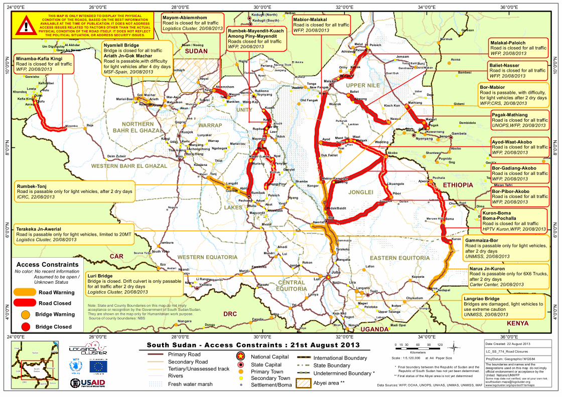
Access Constraints
Road ClosedRoad Warning
South Sudan - Access Constraints : 21st August 2013
Note: State and County Boundaries on this map do not implyacceptance or recognition by the Government of South Sudan/Sudan.They are shown on the map only for Humanitarian work purpose. Source of county boundaries: NBS
Some map data not verified, use at your own [email protected];www.logcluster.org/ops/ssd11a/maps
Bor-Pibor-AkoboRoad is closed for all trafficWFP, 20/08/2013
Terakeka Jn-AwerialRoad is passable only for light vehicles, limited to 20MTLogistics Cluster, 20/08/2013
Secondary Town
National Capital^
!(
Bridge Warning!(
CENTRALEQUITORIA
EASTERN EQUITORIA
JONGLEI
Minamba-Kafia KingiRoad is closed for all trafficWFP, 20/08/2013
Malakal-PaloichRoad is closed for all trafficWFP, 20/08/2013
Luri BridgeBridge is closed. Drift culvert is only passablefor all traffic after 2 dry daysLogistics Cluster, 20/08/2013
Luri
Abyei area **! Settlement/BomaUndetermined Boundary * ** Final status of the Abyei area is not yet determined
* Final boundary between the Republic of Sudan and the Republic of South Sudan has not yet been determined.
!(
Mabior-MalakalRoad is closed for all trafficWFP, 20/08/2013
Bridge Closed!(
THIS MAP IS ONLY INTENDED TO DISPLAY THE PHYSICALCONDITION OF THE ROADS, BASED ON THE BEST INFORMATION
AVAILABLE AT THE TIME OF PUBLICATION. IT DOES NOT ADDRESSACCESS ISSUES RELATED TO FACTORS OTHER THAN THE ACTUAL
PHYSICAL CONDITION OF THE ROAD ITSELF. IT DOES NOT REFLECT THE POLITICAL SITUATION, OR ADDRESS SECURITY ISSUES.##!
Pagak-MathiangRoad is closed for all trafficUNOPS,WFP, 20/08/2013
No color: No recent information Assumed to be open / Unknown Status
Baliet-NasserRoad is closed for all trafficWFP, 20/08/2013
Nyamlell BridgeBridge is closed for all trafficAriath Jn-Gok MacharRoad is passable,with difficultyfor light vehicles after 4 dry daysMSF-Spain, 20/08/2013
Mayom-AbiemnhomRoad is closed for all trafficLogistics Cluster, 20/08/2013 Rumbek-Mayendit-Kuach
Among Piny-MayenditRoads closed for all trafficWFP, 20/08/2013
Kuron-BomaBoma-PochallaRoad is closed for all trafficHPTV Kuron,WFP, 20/08/2013
Bor-Gadiang-AkoboRoad is closed for all trafficWFP, 20/08/2013
Ayod-Waat-AkoboRoad is closed for all trafficWFP, 20/08/2013
Bor-MabiorRoad is passable, with difficulty,for light vehicles after 2 dry daysWFP,CRS, 20/08/2013
!(!(Langriao BridgeBridges are damaged, light vehicles touse extreme cautionUNMISS, 20/08/2013
NORTHERNBAHR EL GHAZAL
UPPER NILE
Narus Jn-KuronRoad is passable only for 6X6 Trucks,after 2 dry daysCarter Center, 20/08/2013
Gammaiza-BorRoad is passable only for light vehicles,after 2 dry daysUNMISS, 20/08/2013
Rumbek-TonjRoad is passable only for light vehicles, after 2 dry daysICRC, 22/08/2013


![3. Nat. OL Kandersteg 2019 / 56.Thuner-OL - olg-thun.ch · [Hier eingeben] Die OLG Thun lädt alle OL-Läufer und OL-Läuferinnen herzlich ein zum: 3. Nat. OL Kandersteg 2019](https://img.pdfslide.tips/doc/110x75/5e09501c1231581f421642dc/3-nat-ol-kandersteg-2019-56thuner-ol-olg-thunch-hier-eingeben-die-olg.jpg)