Embed Size (px)
DESCRIPTION
Project Management
Citation preview
Lahore Metro Bus System
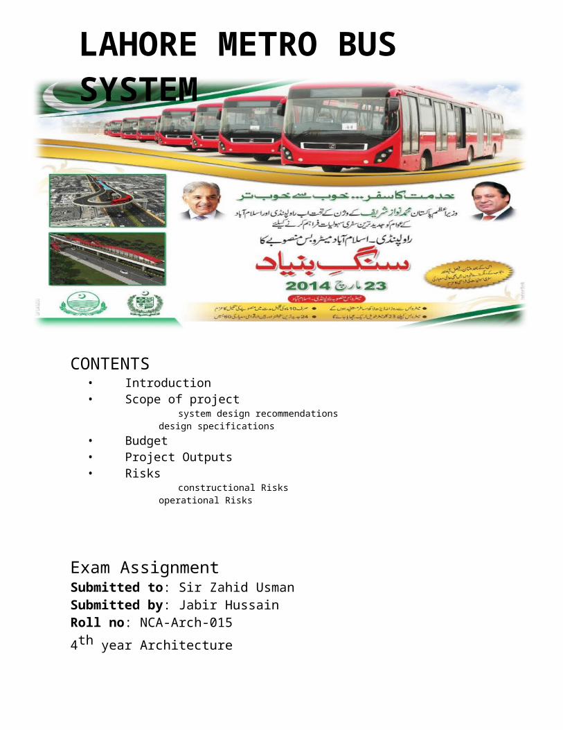
LAHORE METRO BUS SYSTEM
CONTENTS • Introduction • Scope of project
system design recommendations design specifications• Budget• Project Outputs• Risks
constructional Risks operational Risks
Exam AssignmentSubmitted to: Sir Zahid UsmanSubmitted by: Jabir HussainRoll no: NCA-Arch-0154th year Architecture
With the aim to provide safe, efficient and comfortable urban transportation system in Lahore, Metro Bus System was introduced under the supervision of Punjab Metro bus Authority (PMA) which deals in construction, operation and maintenance of mass transit system.
Lahore is the second largest city of Pakistan with estimated population of 10 million. The transport demand recently estimated is 12 million trips, which includes 4 million short walking trips and 8 million motorized trips, on a usual weekday. The number of vehicles registered in Lahore increased sharply from 95 vehicles in 2001 to 238 vehicles in 2008; per 1000 population.
The Lahore Urban Transport Master Plan 2011, prepared by JICA, recommends seven BRT corridors in Lahore. Therefore, in the year 2011, the Government of Punjab appointed “Ulasim” a Turkish based company of the Istanbul Metropolitan Municipality, for preparing the preliminary design of Metrobus System (MBS).
The MBS is planned in integration with Multi-Modal Intercity Bus Terminals (MIBT), one terminal to be established on either side of the corridor, with Park & Ride plazas. The overall transportation map includes integration of Metrobus System & public transport routes, sub-urban railway, LRMTS (other lines), and taxi system in Lahore.
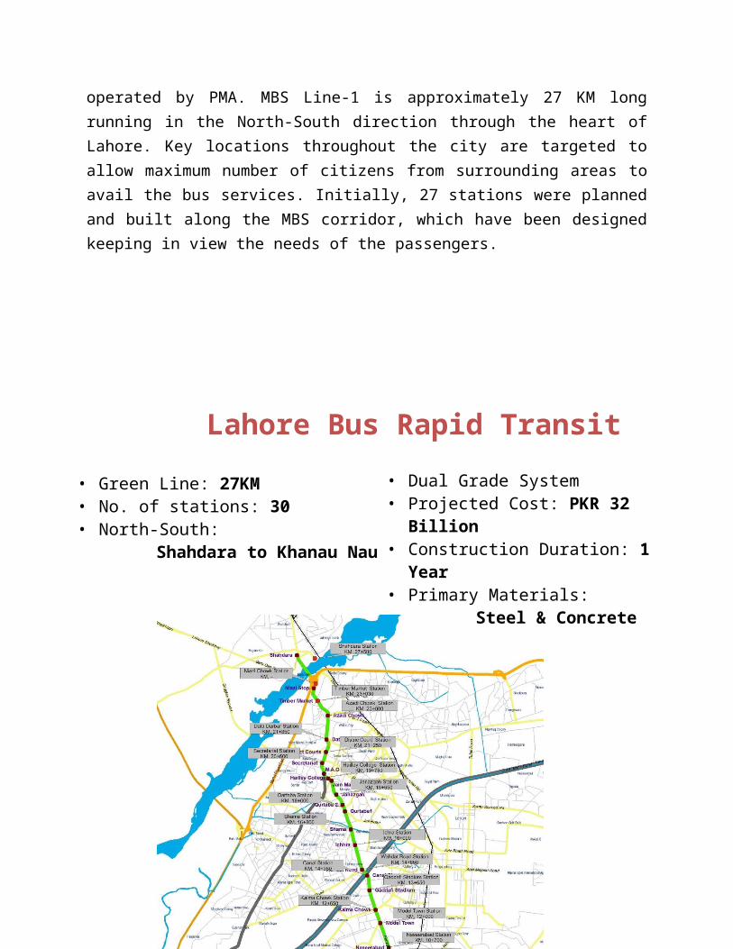
The Metrobus System Line-1 from Gajjumata to Shahdara is established in Lahore, and is the first system to be operated by PMA. MBS Line-1 is approximately 27 KM long running in the North-South direction through the heart of Lahore. Key locations throughout the city are targeted to allow maximum number of citizens from surrounding areas to avail the bus services. Initially, 27 stations were planned and built along the MBS corridor, which have been designed keeping in view the needs of the passengers.
Lahore Bus Rapid Transit
• Green Line: 27KM• No. of stations: 30• North-South:
Shahdara to Khanau Nau
• Dual Grade System• Projected Cost: PKR 32 Billion• Construction Duration: 1 Year• Primary Materials:
Steel & Concrete
SCOPE OF WORK
• Green Line: 27KM• No. of stations: 30• North-South:
Shahdara to Khanau Nau
Broad parameters of the BRT project are as follows:
a. BRT on Ferozepur Road Line Corridor-I 28.7 Km
b. BRT on Multan Road Line Corridor-II 12.4 Km
The scope of work includes design, build, and finance, operate, and transfer of project on the above two corridors on BOT basis:
a) BRT Geometric and System Design Recommendations
Corridor 1
Based on the ridership data of the LRMTS Feasibility Study, the BRT system on Corridor 1 is expected to carry 9,000 peak period passengers per hour per direction (pphpd) by the year by 2011, 20,000 pphpd by the year 2021, and 24,000 pphpd by 2025. For engineering purposes it is much safer to err on the side of designing for more passengers than you get. A BRT system can be built in Corridor I with the nearly the same capacity as the proposed metro system, with an average operating speed of 26 km/h, starting at 9,000 pphpd and increasing to 24,000 pphpd over time.
Corridor 2
Based on the ridership data of the LRMTS Feasibility Study, the BRT system on Corridor 2 is expected to carry 7,300 peak period passengers per hour per direction (pphpd) by the year by 2011, 15,100 pphpd by the year 2021, and 20,300 pphpd by 2025. . For engineering purposes it is much safer to err on the side of designing for more passengers than you get. A BRT system can be built in Corridor 2 with the nearly the same capacity as the proposed metro system, with an average operating speed of 26 km/h.
b) Design Specifications
Reaching these levels of capacity in a BRT system requires careful design and engineering. To reach these levels, BRT system would need to have the following characteristics:
The BRT system should occupy the central verge of the roadway, rather than the curb lanes. This will avoid conflicts with turning traffic, pedestrians, stopping taxis and delivery vehicles, illegally parked vehicles, etc.
Passengers should pre-pay to enter each bus station, and each station platform should be elevated to the height of the bus floor. Each station should have at least two platforms.
Exclusive bus lanes should be predominantly maintained at grade but physically separated from the rest of the traffic by a physical barrier. Fines for illegal encroachment on the bus way must be strictly enforced.
The distance between bus stations should be brought down from the current average 1000 meters to an optimal level of 500 meters. This will slow down bus speeds somewhat (30 to 25km/h) but it will reduce total trip time by reducing walking distances. Approximately fifty six stations on Corridor-I with 112 prepaid enclosed platforms should be built along Corridor I. Similarly twenty four stations on Corridor-II with 48 pre-paid enclosed platforms should be built along.
For Corridor I, two hundred (200) buses and for Corridor II one hundred buses (100) with capacity of 75-passengers are required (other spec as per LTC bus specification Annex- G).
Pedestrian access to the central verge should be via pedestrian overpasses and underpasses unless impractical.
If it is determined that at-grade design of BRT system at any intersection is expected to significantly hamper the cross street traffic or the turning traffic, causing Level of Service F (based on the standards provided in the latest edition of the Highway Capacity Manual of Transportation Research Board); or is expected to create a safety related problem likely to cause injuries or deaths to the citizens, a grade separated design solution for securing the BRT corridor shall be provided.
Visually distinct pavement color for identifying the secured BRT corridor is
to be provided.
Budget
The project cost Rs29.8 billion for 27 kilometres of track and 45 buses. Yes, just 45 buses. This means the fixed cost was Rs1.103bn per kilometre, or Rs11.0 lakh per foot of track/road.In terms of buses this means Rs662.2 million per bus. Had there been more buses, naturally, the cost per bus would decrease.
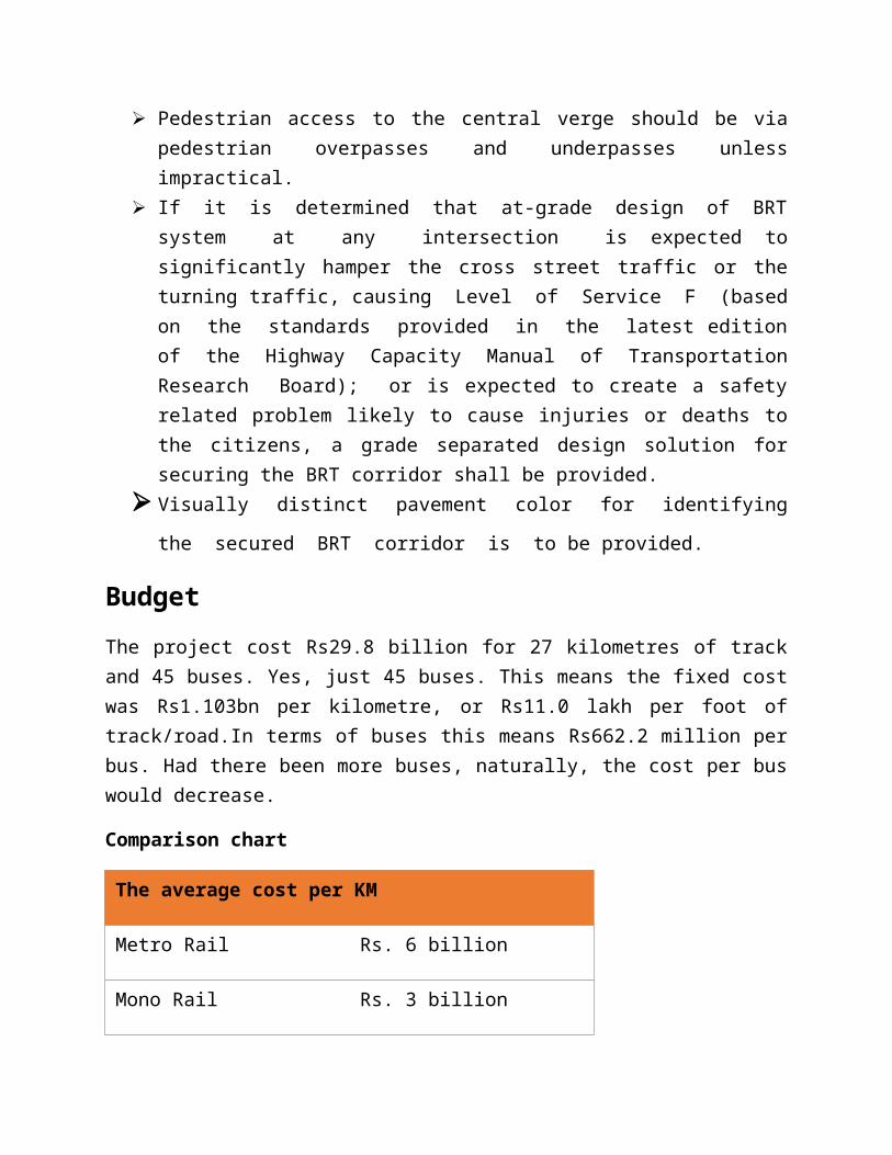
Comparison chart
The average cost per KM
Metro Rail Rs. 6 billion
Mono Rail Rs. 3 billion
Elevated BRT Rs. 1.5 billion
At-Grade BRT Rs. 0.5 billion.
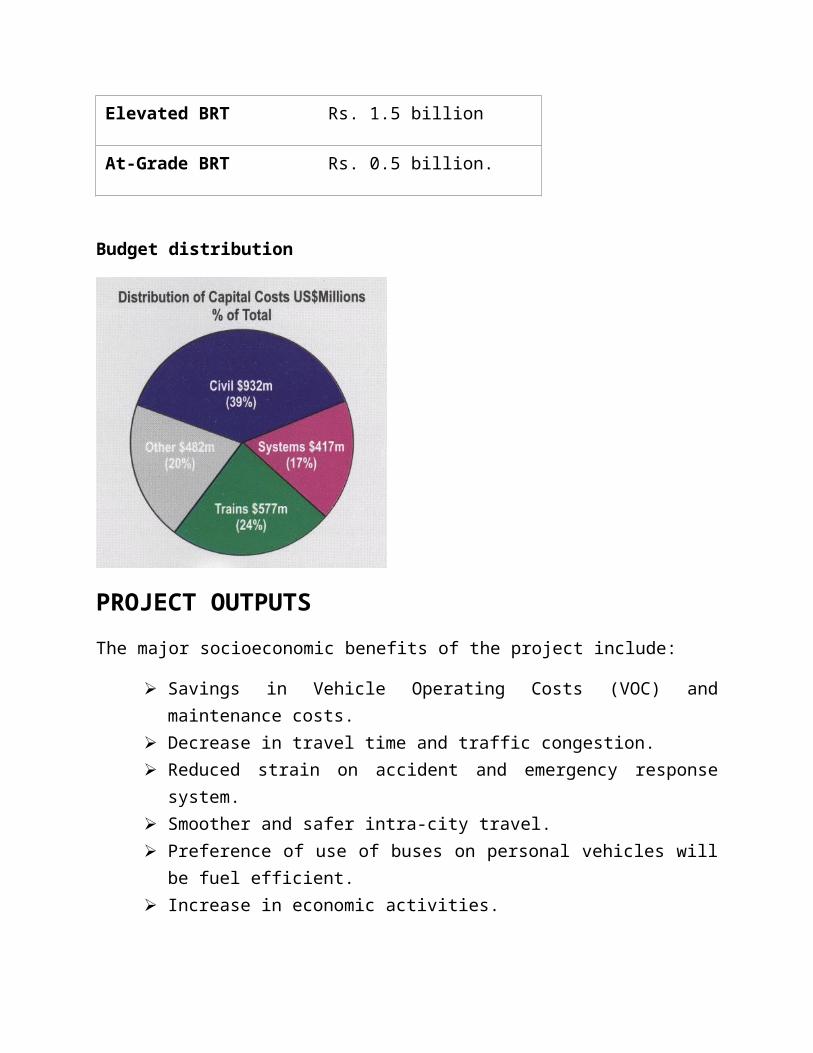
Budget distribution
PROJECT OUTPUTS
The major socioeconomic benefits of the project include:
Savings in Vehicle Operating Costs (VOC) and maintenance costs. Decrease in travel time and traffic congestion. Reduced strain on accident and emergency response system. Smoother and safer intra-city travel. Preference of use of buses on personal vehicles will be fuel efficient. Increase in economic activities. Increase in employment opportunities during construction and post
construction period. Additional revenue via advertisement buses. Maintain standards of safety and speed and manage traffic equitably, which
may reduce the economic cost of travel on the aforementioned traffic routes. Reduce traffic load from the areas of high activity, providing ample capacity
on the main boulevards to cater for the prospective growth in the city traffic.
Risks
1. Constructional 2. Operational
Construction Risks
Noise and air pollution. Fatal accidents caused by unattended constructional material. Traffic congestion. Dust causing breathing problems. Compensation for destroyed property not even discussed before the
commencement of the project resulting in people being forced to shift away or sell them.
The compensation is estimated to cost billions of rupees.
Operational Risks
The route passes through densely populated area, so in case of any disaster it may cause many deaths.
No proper drainage and the water seeps when it rains which may affect strength of the flyover.
Run by high voltage generators which cause pollution as well as danger of short circuiting.
There are no specially designed U-turns in front of some hospitals on the Ferozepur Road.