Embed Size (px)
Citation preview

KARAIN AND OKUZINI CAVES. TURKEY GENERAL GEOLOGY OF AREA
PRELIMINARY REPORT
Mac i ek PA WL1K OWSKI
ÖZET
İncelenen alan Türkiye'nin güneyinde, Antalya ilinin yakınında bulunmaktadır (Fig. 1). Önemi, kratese dönemi kalkerleri içinde gelişmiş olan geniş mağaralann varlığından ileri gelmektedir. Söz konusu mağaralar, prehistorik seviyelerin uzun silsilelerini içeren tortullarla dolmuşlardır.
Karain ve Öküzini mağaraları, Ankara Üniversitesinden Prof. Yalçınkaya ve Liège Üniversitesi'nden Prof. Marcel Otte tarafından yürütülen yoğun bilimsel araştırmaların konusunu oluşturmaktadırlar. Bu çalışmalar, Ankara Üniversitesi'nden Prof. İ.K. Kökten'in bazı aralarla yaptığı çalışmaları izlemektedir. Karain mağarası Ye- niköy ilçesinde, Yağca Köyünün yakınlarında, Katran Dağının yamaçları üzerinde yer almaktadır.
Öküzini mağarası ise Karain’in kuzey doğusunda, aktüel alüv- yal ova ile dağın bitiştiği yerde bulunmaktadır.
CONTENTS
1. Introduction2. Morphology of the area3. Geology and stratigraphy4. Genesis of Karain Cave5 Genesis of Okuzini Cave6 Summary

352 Karain v e O k u zın ı Caves
1. Introduction
Investigated area is localized at the southern Turkey near of Antalya City (Fig. 1). The importance of this place is due to the presence of big caves developed in cretaceous limestones. These caves are filled up with sediments containing long sequences of prehistoric layers.
Two caves, Karain and Okuzini are the objects of intensive scientific investigation conducted by international expedition.
Karain cave was explorated by İ. Kılıç Kökten in 1946.It is localized near of the Yağca village on the eastern slopes
of Katran Dagi Mountains (Fig. 1).
The second cave, Okuzini is located near of the Karain cave. It is developed at the base of the same Mountains (Fig. 2). The sediments of this cave were tested by German expedition in 1989.
2. Morphology of the area
The area under the consideration is built of two completly different morphological zones.
The first one is represented by mountains (Katran Dagi) with the highest hill elevated about 1450 metres above sea leval. The morphology of the mountains is sharp. Slopes are cut by short valleys, vertical walls and high ridges.
Mountains contact with flat area (plain). The difference between elevation of the mountains and the plain is about 1100 metres. The plain is elevated about 350 metres above sea leval and the morphological surface of the plain is near flat or slightly diping to the west. This area is cut by valleys seasonally filled by water and artificially made canals conducting water for the agriculture.
Surface waters are coming down from the mountains seasonally. When rivers pass in to the plain they lost the velocity and the force of the transportation. This phenomenon conducts to the abrupt sedimentation of the detrital material, near of the base of the hills, on the plain. The material is deposited in the form of sedi- — mentary cones.

K arain v e O k u zın ı C aves 353
Fig. 1

3 5 4 K arain v e O k u z in i C aves
Fig.
2

Karain v e O k u zın ı Caves 355
This type of the detrital material is transported only some hundred metres far from of the hills.
The plain is continued in to the direction of sea shore (to the east) and is tectonically cut by big fault near of the Antalya City.
3. Geology and stratigraphy
Morphology of the area is the effect of the geological phenomenons (tectonic) as well as stratigraphy of the rocks (Fig. 3).
Radiolarites (R)
Cretaceous radiolarites are the oldest sediments observed between Yeniköy and Bıyıklı villages. The natural outcrops of radiolarites are observed near of Çakmak Tepesi (Fig. 4) where one can observe about 40 metres thick formation of these rocks. The formation is even thicker but their bottom is not observed at investigated area.
Formation of radiolarites is composed of thin layers of siliceous rock (Fig. 5) undulated and cut by faults of different size. Layers of the radiolarites are intercalated with thin layers of grey claystones. The thicknes of individual radiolarite layers is maximum up to 25-30 cm. Radiolarites are craked tectonically and the size of the faults in probably even up to hundreds metres. The direction of the faults is orientated first of all to the north-south with deviations to the east-west. The faults are vertical of near vertical.
Together with the faults are observed overtrusts showing direction orientated to the north-south. Together with overtrusts are observed undulations. The axes of these undulations is west-east orientated. The amplitude of undulations is differentiated.
The part of the faults cuting the radiolarites is passing in to overlaying cretaceous limestones containing caves. This fact documents tectonic activity of the area after sedimentation of cretaceous limestones. Tectonic activity is observed even up ton now as earth- queaks.
The top of the serie of radiolarites is cut by the erosion active before the sedimentation of overlaying cretaceous limestones. This fact documents the brake between sedimentation of the radiolarites and limestones.

3 5 6 Karain v e O k uzın ı C aves
O l ^ 2 ^ 3 [ m ] 4
E Ê 3 5 Ë H 6 X 7Fig. 3

K arain v e O k u zın ı Caves 357
Fig.
4

358 Karain ve O k u zm i Caves
Limestones (L)
The limestones overlaying radiolarites are more than 1200 metres thick. They are represented by micritic modification and contain zoogenic horizonts with skeletons of moluscs and gastropods etc. These layers documents oscilation of the bottom of the sea during the sedimentation of the limestones, when chemical sedimentation passed in to the deposition of skeletons of organisms.
Uplifting of the mountains started after Cretaceous, i.e. in al- peian orogenese.
The erosion and development of the karst of Katran Dagi Massive started just after uplifting.
The sediments of paleogene, neogene and quaternary were deposited on eroded morfological surface of cretaceous limestones.
In conclusion one can say the radiolarites are dipping under the massive of limestones but as pebbles deposited at secondary position are present in younger sediments overlaying the limestones (paleogene, neogene, quaternary). These younger sediments were the sources of the pebbles of the radiolarites introducted by water to the sediments of the caves (third position).
Additionally one can say the tectonic played an important role during the formation of the karstic forms. The faults were the best place for the development of the caves. Tectonic activity conducted to the opening of earlier development caves.
Sediments younger then ceretaceous
These sediments are of mechanical (detrital) and chemical origin.
Detrital sediments cover the plain and are present in the mountains (Fig. 3).
Radiolarites and limestones were the most important source of the material for these sediments. Conglomerates, sands and clays are most frequent rocks representing secondary deposis of R and L.
Slopes of the mountains are covered by clastogenes composed of sharp blocks of limestones mixed with red clay (terra rossa). They are of gravital origin.

Karain v e O k uzin i C aves 359
sample
1 c m
1 cm
0.5 cm1 cm
1 cm
1 cm
1 cm
1 cm
1 cm
n
3 I HZ J
1cm
1 cm
1cm
■ 3 cm
1 cm 1 cm 1 cm
1 cm
1 cm
1 cmT T T
8 cm R Ye l lo w
9 cm R G r e e n
7cm R Gr een a n d Red
5cm R G r e e n
12cm R G r e e n
8 cm R Gr een
15cm R Pink a n d Red
8 cm R G r e e n
8 cm R G r e e n4 cm R G r e e n a n d Yet iow
75cm Red a n d G r e e n
12.5 cm R Gr een
6 cm R Green
8.5cm R G r e e n
6 cm R 2 cm R 5cm R10.5 cm
R
12cm R
6cm R5.5 cm R
Pi nk a n d Red Green a n d Yel low P i n k a nd Red
G r e e n
G r e e n
Re d
Red
Fig. 5

360 Karain v e O k uzim Caves
Similar sediments transported by water contains rounded blocks of limestones mixed with terra rossa.
The beds of the rivers cut limestones and radiolarites. They are filled up with the mixture of pebles of limestone and radiolarite. The size of these pebbles and the roundnes depends on the distance of the water transport. In the mountains they are represented by conglomerates, in the plain by sands.
Terra rossa is observed, at first position, as residuum developed on limestones (Fig. 6) or, more often as red clays, redeposited by the water, on the plain or into the caves.
terra rossa in situ
Mixtures of described above three types of sediments are very common at investigated area (Fig. 7).
Sands composed of quartz, sometime mixed with grains of limestones, are observed too. They are present on the plain, in front of the mountains. Their origin is due to weathering of the soft sandstones observed in the tectonic clif near of the Antalya.

Karain v e O k u z in . •> 361
r-~soE

362 Karain v e O k u zin i Caves
Sediments of chemical origin are represented by travertines. This type of the rock is deposited during the crystalization of the calcite from the waters comming out from karstic spaces developed in the limestone. The crystalization of this mineral is the result of the change of the chemical balance of the water after her coming out from the closed spaces of the karstic forms. This process is connected with the removing of the part of CO from the water and reduction of the solubility of the calcitein the water. Crystalizing this way calcite is cementaiting each type of the material (sand, pebbles, archaeological material etc.). After years soft calcite is recrys- tallizing into hard travertine. On the other hand flowing water is ad- ditionaly the transporter of the detrital material.
Described type of the travertine is observed in the caves (Karain) as well as on the plain.
4. Genesis of Karain Caves
Karain caves are composed of long sequence of halls and rooms of differentiated size. These empty spaces are coming down irregulary from the west to the south and later with changes of the orientation to the northern east and east. The difference between upper cave and lower one is about 40 metres on the distance of about 100-150 metres. The changes of the direction of this sequence of caves is very frequent. Each cave of this system is filled up with the sediments represented mainly by travertines and mixtures of travertine and redeposited terra rossa. The localization as well as the morfology of the bottom of the caves are unknown. Only in the cave E explorated earlier by Kokten the bottom was discovered on the depth about 12 metres below the top of the sediments filling up the cave.
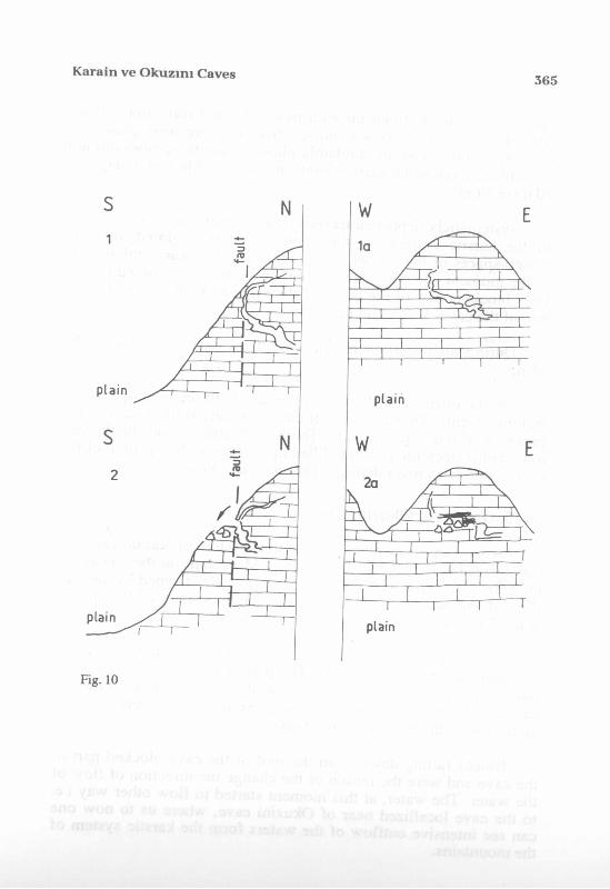
Observations of the hill of Karain caves as well as walls of entrance to the caves shoved that this karstic system was formed in the hill at the place of the presence of tectonic fault cutting limestones. The system of caves was opened tectonically when, after earthquek and activity of old fault, part of wall of the caves fall down (Fig. 10). Fragments of this wall in the form of big blocks is up to now present in front of the entrance of the caves. Part of these blocks is covered by travertines.
When the system of Karain caves have been tectonically opened the travertine started crystallize. The system of the opened

Karain ve O k uzın ı Caves 363
Fig.
8
Q
364 Karain v e O k u zın ı Caves
600
400
f
600 -
4 0 0 -
600
400
K arain ve O kuzın ı Caves 365
Fig. 10

366 Karain v e O k u zim C aves
caves started to be filled up with newly formed travertines. Sedimentation of travertines was not continous. There were phases of erosion of travertines and probably phases when travertines did not crystallise. Even some karstic forms are observed in newly deposited travertines.
Systematicly deposited travertine, after many years, closed part of the karstic system. At this moment water migrated again in closed spaces of the part of caves. This situation was continued up to the moment when intensive action of the water destroyed travertines blocking part of the caves of the system. At this moment system of the caves was again opened.
During all this time Karain system of caves was visited by Man.
On the other hand there are other caves in the area opened by tectonic events. They are seen in the mountains at the places of the presence of red vertical walls. These walls are the part of the tectonic faults (tectonic fissures) filled up, before of the opening of the caves, with terra rossa deposited at secondary position.
5. Genesis of Okuzini Cave
Okuzini cave has other genesis than system of Karain caves. It was formed at the base of Katran Dagi Mountains, at the contact of the base of the hills with the plain. The cave was formed by the outflow of the waters conducted by the carstic system of the mountains. The cave was enlarged by flowing water.
Observations shoved thé cave was at one moment blocked, probably tectonically (Fig. 11). The part of the roof fall down and blocked internal part of the cave as well as the area near of the entrance in to the cave. Fragments of these destroyed parts are seen up to now as the blocks of limestones.
Blocks falling down from the roof of the cave blocked part of the cave and were the reason of the change the direction of flow of the water. The water, at this moment started to flow other way i.e. to the cave locallized near of Okuzini cave, where us to now one can see intensive outflow of the waters form the karstic system of the mountains.

Karain ve O k uzın ı Caves 367
ı ^ rI- ' .-""T
i r
2 .
w
368 Karain v e O k uzim Caves
Okuzini cave, at the moment of tectonic blocking, started to be dry and useful for human occupation.
6. Conclusion
The understanding of general geology of area is important from point of viev of explanation of phenomenons developed in thecaves.
System of Karain caves gives opportunity of understanding of climatic changes and human activity during last, about 500 000 years.
Sediments filling up Okuzini cave may explain phenomenons at the moment of transition of Pleistocene to Holocene.
Both caves were filled up with the sediments deposited in many phases separated by erosion. All these processes conducted to the destruction of antropogenic structures observed in archaeological horizons of both caves.
This preliminary raport explain general geology of area and genesis of the caves. Detailed explanation of phenomenons (climatic, human activity etc.) need continuation of the investigation of sediments present in the caves.
EXPLANATION FO R FIG URES
Fig. 1A. General locallization of investigated area x- region of Karain and Okuzini caves.B. Morphological map of the region of Karain cave.1- arrows show the entrances of the surface waters into the karstic system of Karain cave.2- water canal.a-h, I-IV- morphological cross sections shoved at fig. 9.
Hg. 2 Morphological map of the region of Okuzini cave.1- arrows showing the entrances of surface waters into the karstic system of Okuzini cave.2- water canal.
Fig. 3 General, geological map of the area.1- Quaternary, 2- Neogene, 3- Paleogene, 4- Cretaceous, 5- Juriassic, 6- Trias,— 7- tested area.
Karain v e O k u zın ı Caves 369
Fig. 4 Outcrop of radiolarites underlaying cretaceous limestones.(Çakmak Tepesi -Cafebar Krain). Squere showers in details on fig. 5.
Fig. 5 Example of the part o f the sequence of the radiolarites shown on fig. 4.
Fig. 6 Terra rossa "in situ" present between the blocks of limestones.
Fig. 7 A Area of the presence of the outcrops of radiolarites and river sediments (Kızılin River) containing blocks of radiolarites (marked) used for preparation of implements in both caves.(Fig. 4 -outcrop of radiolrrites).B. Sediments transported by water composed of pebles of limestones and radiolarites mixed with terra rossa at secondary position.
Fig. 8 General viev of entrance to the system of Karain caves.
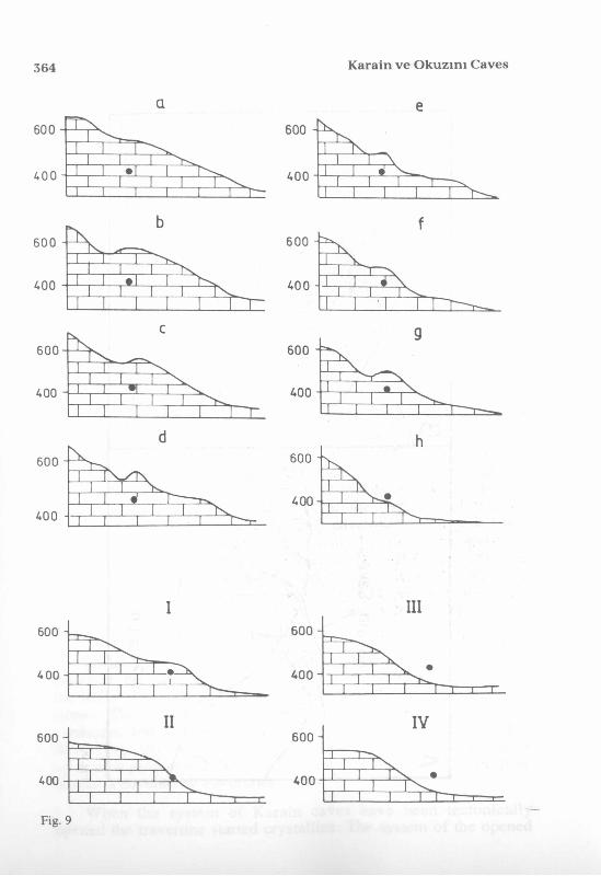
Fig. 9 Morphological cross sections of the hill of Karain cave (shown on fig. 1). a-h- cross sections SW-NE.I-IV- cross sections NW-SE.spot- localization of the entrance to Karain cave.
Fig. 10 Scheme of the opening o f Karain cave.1- Phase of closed cave developed at the area of presence tectonic fault. Cross section S-N.la- cross section W-E.2- Phase of opened cave after tectonic activity. Cross section S-N.2a- cross section W-E.
Fig. 11 Scheme of the blocking of Okuzin Cave.1. Phase of functioning of the cave as the outflow of karstic waters. Cross section W-E.2. Phase of the blocking of the cave. Change of the direction of flowing, karstic waters into new outflow functioning up to now near of the Okuzin cave.
TABLE DES M A TIERES
1. Introduction.
2. Morphologie de l'endroit.
3. Géologie et stratigraphie.
4. Genèse de la grotte de Karain.
5. Genèse de la grotte d’Oküzini.
6. Résumé.