Embed Size (px)
Citation preview
Laguna Lakeshore Expressway- Dike Project (LLEDP)
Innovations to Finance the Philippine’s Biggest Tollroad cum Flood Control Dike Project
In cooperation with
Department of Public Works and Highways
Laguna Lake Development Authority
Engr. Maria Catalina E. Cabral, Ph.D. Undersecretary for Planning and PPP, DPWH
IBTTA Annual MeetingThe Economics of the World’s Transportation System – Fuel for Thought
September 1, 2015
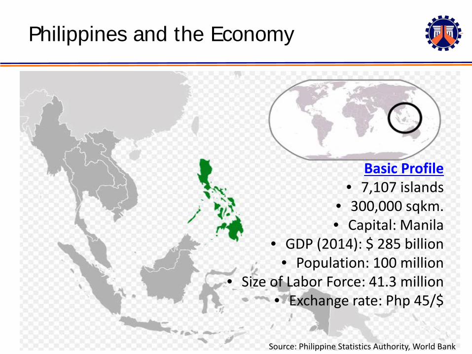
Philippines and the Economy
Source: Philippine Statistics Authority, World Bank
Basic Profile• 7,107 islands
• 300,000 sqkm.• Capital: Manila
• GDP (2014): $ 285 billion• Population: 100 million
• Size of Labor Force: 41.3 million• Exchange rate: Php 45/$
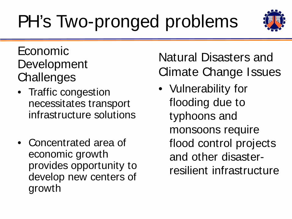
PH’s Two-pronged problemsEconomic Development Challenges• Traffic congestion
necessitates transport infrastructure solutions
• Concentrated area of economic growth provides opportunity to develop new centers of growth
Natural Disasters and Climate Change Issues• Vulnerability for
flooding due to typhoons and monsoons require flood control projects and other disaster-resilient infrastructure
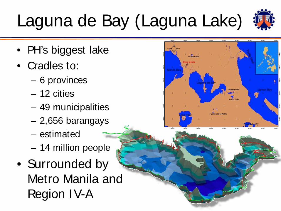
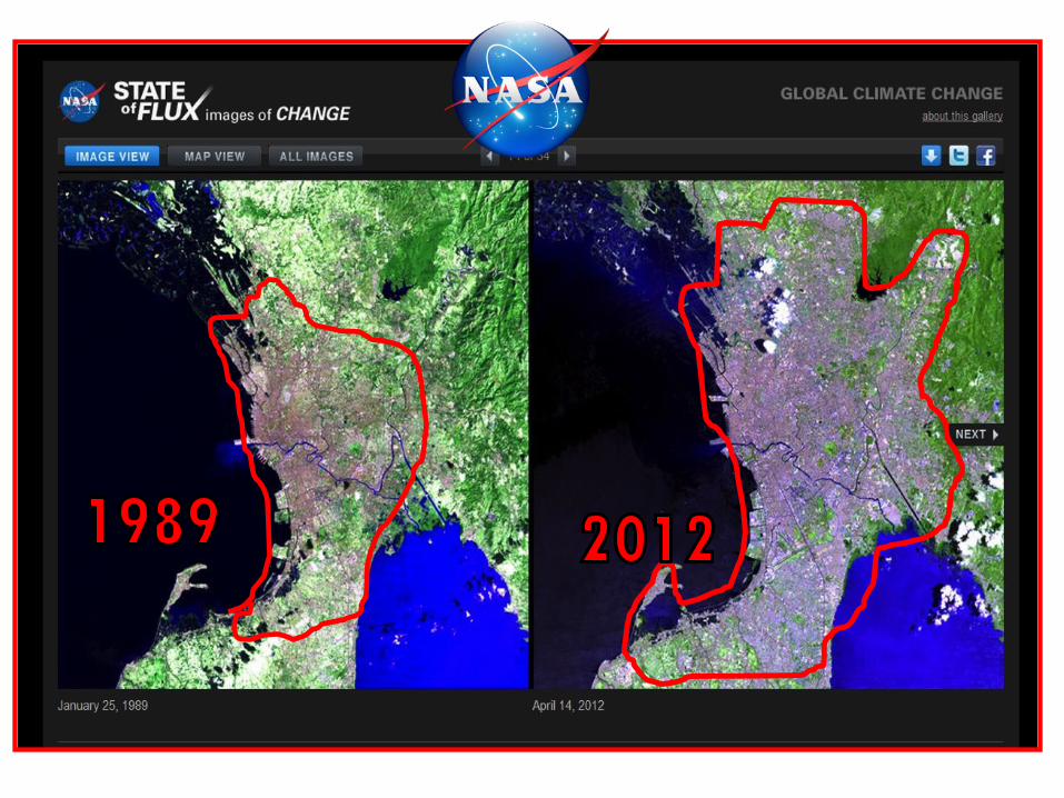
Laguna de Bay (Laguna Lake)
• PH’s biggest lake• Cradles to:
– 6 provinces– 12 cities– 49 municipalities– 2,656 barangays– estimated – 14 million people
• Surrounded by Metro Manila and Region IV-A
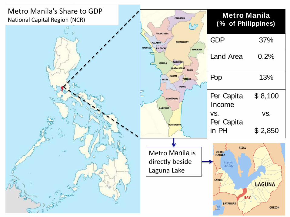
Metro Manila(% of Philippines)
GDP 37%
Land Area 0.2%
Pop 13%
Per Capita Income vs. Per Capita in PH
$ 8,100
vs.
$ 2,850
Metro Manila’s Share to GDPNational Capital Region (NCR)
Metro Manila is directly beside Laguna Lake
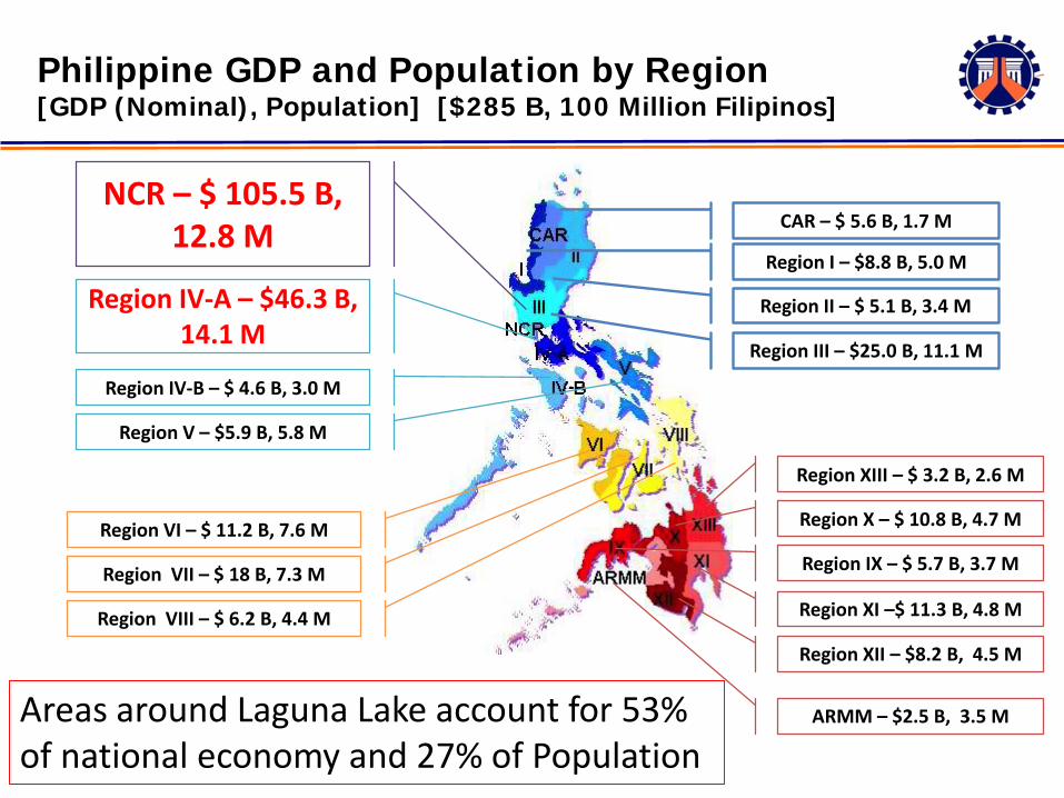
CAR – $ 5.6 B, 1.7 M
Region I – $8.8 B, 5.0 M
Region II – $ 5.1 B, 3.4 M
Region III – $25.0 B, 11.1 M
Region XIII – $ 3.2 B, 2.6 M
Region X – $ 10.8 B, 4.7 M
Region IX – $ 5.7 B, 3.7 M
Region XI –$ 11.3 B, 4.8 M
Region XII – $8.2 B, 4.5 M
NCR – $ 105.5 B, 12.8 M
Region IV-A – $46.3 B, 14.1 M
Region IV-B – $ 4.6 B, 3.0 M
Region V – $5.9 B, 5.8 M
Region VI – $ 11.2 B, 7.6 M
Region VII – $ 18 B, 7.3 M
Region VIII – $ 6.2 B, 4.4 M
Philippine GDP and Population by Region[GDP (Nominal), Population] [$285 B, 100 Million Filipinos]
ARMM – $2.5 B, 3.5 MAreas around Laguna Lake account for 53% of national economy and 27% of Population
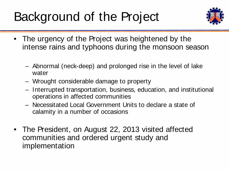
Background of the Project
• The urgency of the Project was heightened by the intense rains and typhoons during the monsoon season
– Abnormal (neck-deep) and prolonged rise in the level of lake water
– Wrought considerable damage to property – Interrupted transportation, business, education, and institutional
operations in affected communities– Necessitated Local Government Units to declare a state of
calamity in a number of occasions
• The President, on August 22, 2013 visited affected communities and ordered urgent study and implementation
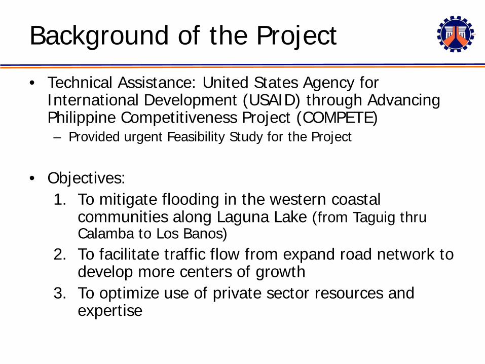
Background of the Project
• Technical Assistance: United States Agency for International Development (USAID) through Advancing Philippine Competitiveness Project (COMPETE)– Provided urgent Feasibility Study for the Project
• Objectives: 1. To mitigate flooding in the western coastal
communities along Laguna Lake (from Taguig thru Calamba to Los Banos)
2. To facilitate traffic flow from expand road network to develop more centers of growth
3. To optimize use of private sector resources and expertise
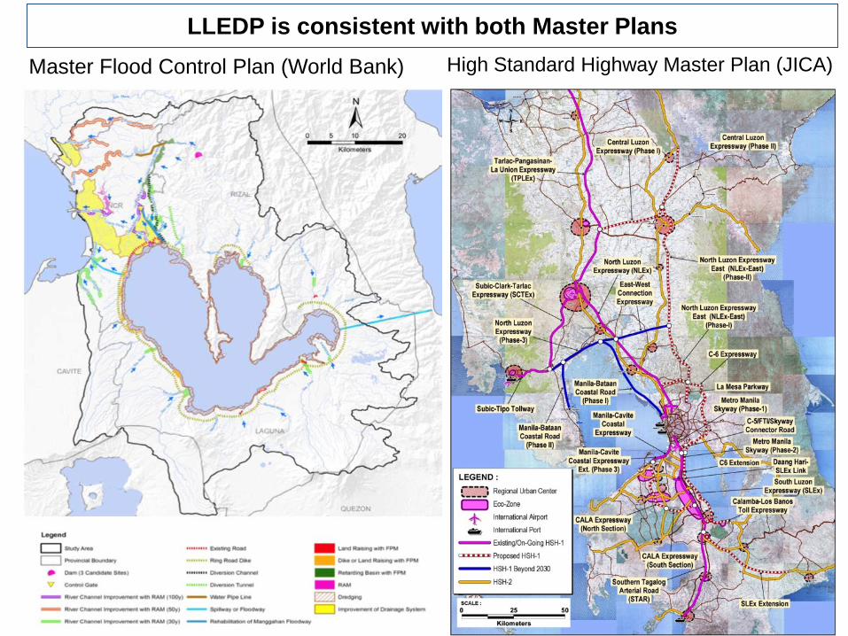
Master Flood Control Plan (World Bank) High Standard Highway Master Plan (JICA)
LLEDP is consistent with both Master Plans
12
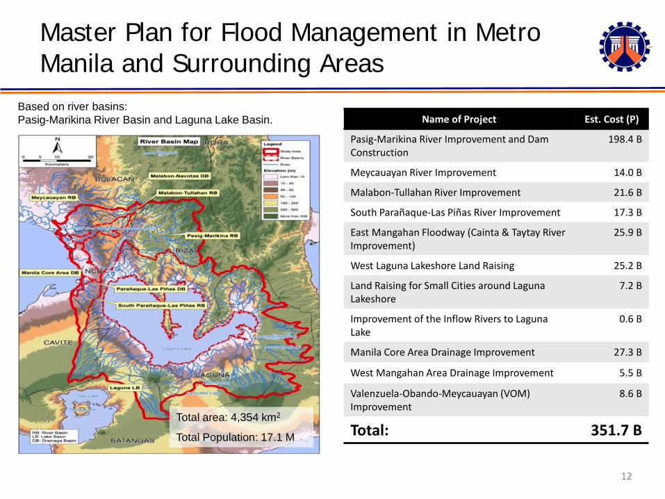
Name of Project Est. Cost (P)
Pasig-Marikina River Improvement and Dam Construction
198.4 B
Meycauayan River Improvement 14.0 B
Malabon-Tullahan River Improvement 21.6 B
South Parañaque-Las Piñas River Improvement 17.3 B
East Mangahan Floodway (Cainta & Taytay River Improvement)
25.9 B
West Laguna Lakeshore Land Raising 25.2 B
Land Raising for Small Cities around Laguna Lakeshore
7.2 B
Improvement of the Inflow Rivers to Laguna Lake
0.6 B
Manila Core Area Drainage Improvement 27.3 B
West Mangahan Area Drainage Improvement 5.5 B
Valenzuela-Obando-Meycauayan (VOM) Improvement
8.6 B
Total: 351.7 B
Based on river basins:Pasig-Marikina River Basin and Laguna Lake Basin.
Total area: 4,354 km2
Total Population: 17.1 M
Master Plan for Flood Management in Metro Manila and Surrounding Areas
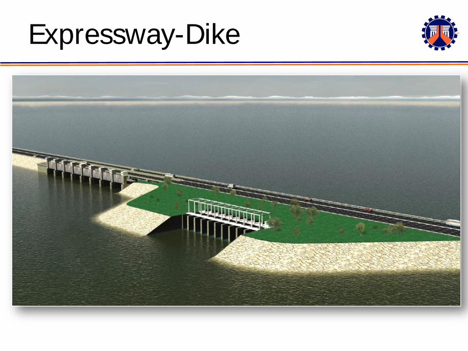
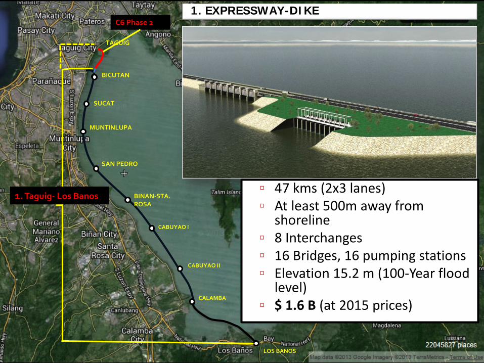
Expressway-Dike
TAGUIG
BICUTAN
SUCAT
MUNTINLUPA
SAN PEDRO
BINAN-STA. ROSA
CABUYAO I
CABUYAO II
CALAMBA
LOS BANOS
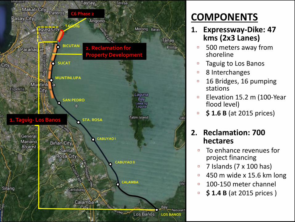
1. Taguig- Los Banos
C6 Phase 21. EXPRESSWAY-DIKE
47 kms (2x3 lanes) At least 500m away from
shoreline 8 Interchanges 16 Bridges, 16 pumping stations Elevation 15.2 m (100-Year flood
level) $ 1.6 B (at 2015 prices)
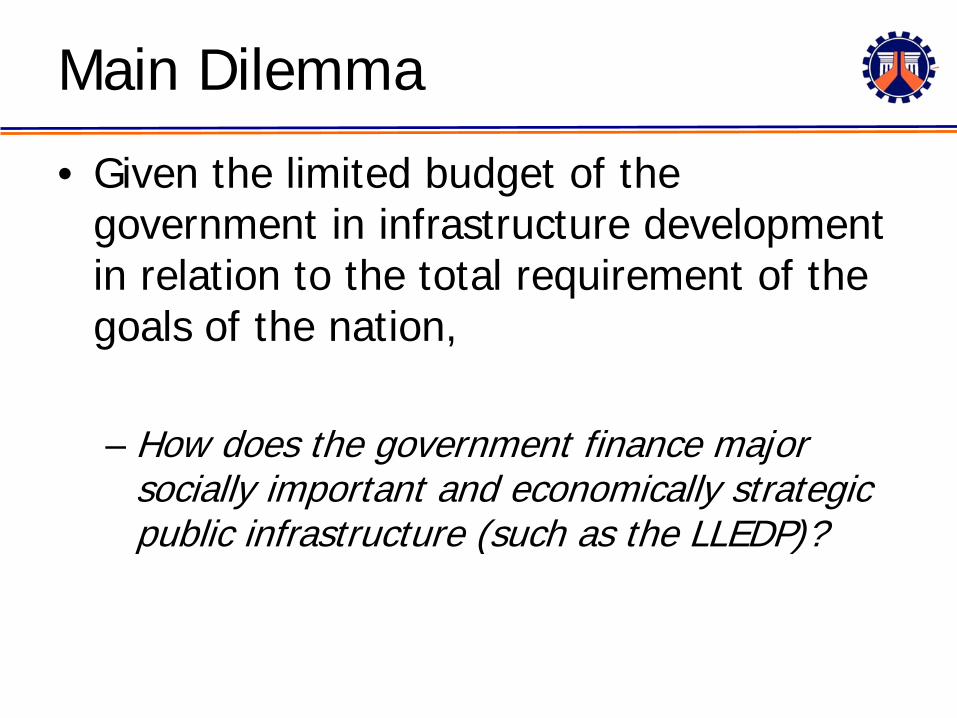
Main Dilemma
• Given the limited budget of the government in infrastructure development in relation to the total requirement of the goals of the nation,
– How does the government finance major socially important and economically strategic public infrastructure (such as the LLEDP)?
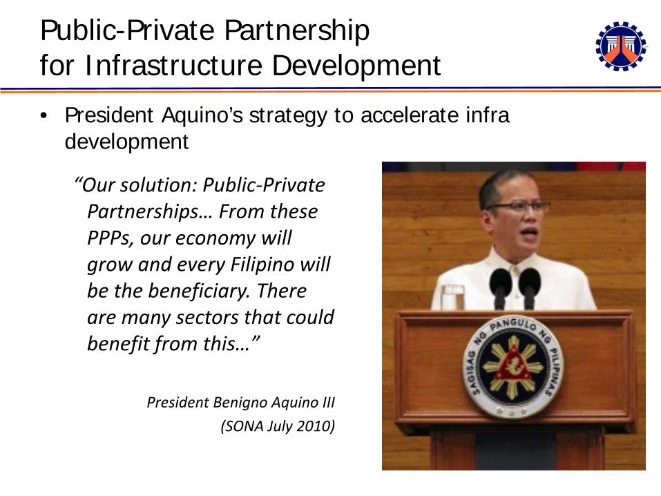
Public-Private Partnershipfor Infrastructure Development
• President Aquino’s strategy to accelerate infra development
“Our solution: Public-Private Partnerships… From these PPPs, our economy will grow and every Filipino will be the beneficiary. There are many sectors that could benefit from this…”
President Benigno Aquino III (SONA July 2010)
0%
5%
10%
15%
20%
25%
30%
35%
40%
45%
1991
1992
1993
1994
1995
1996
1997
1998
1999
2000
2001
2002
2003
2004
2005
2006
2007
2008
2009
2010
2011
2012
2013
2014
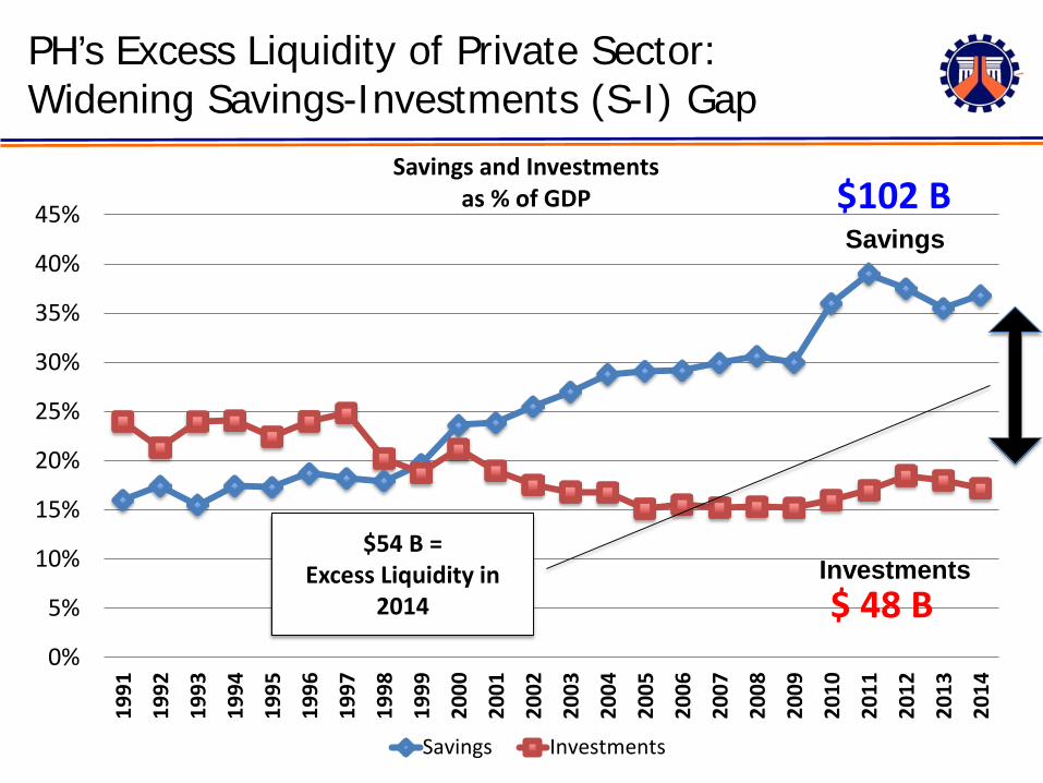
Savings and Investmentsas % of GDP
Savings Investments
PH’s Excess Liquidity of Private Sector: Widening Savings-Investments (S-I) Gap
Savings
Investments$ 48 B
$102 B
$54 B = Excess Liquidity in
2014
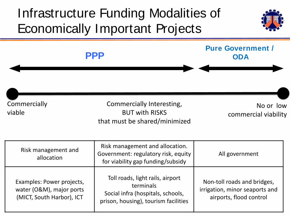
Infrastructure Funding Modalities of Economically Important Projects
Risk management and allocation
Risk management and allocation.Government: regulatory risk, equity
for viability gap funding/subsidyAll government
Examples: Power projects, water (O&M), major ports (MICT, South Harbor), ICT
Toll roads, light rails, airport terminals
Social infra (hospitals, schools, prison, housing), tourism facilities
Non-toll roads and bridges, irrigation, minor seaports and
airports, flood control
PPPPure Government /
ODA
No or low commercial viability
Commercially viable
Commercially Interesting, BUT with RISKS
that must be shared/minimized
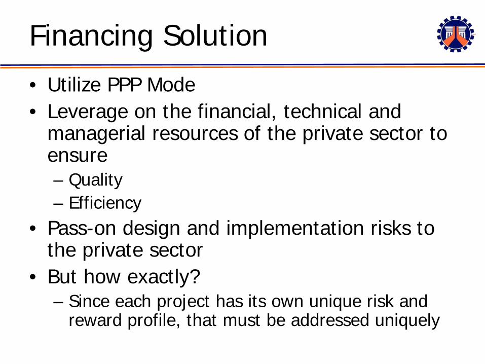
Financing Solution• Utilize PPP Mode• Leverage on the financial, technical and
managerial resources of the private sector to ensure– Quality – Efficiency
• Pass-on design and implementation risks to the private sector
• But how exactly?– Since each project has its own unique risk and
reward profile, that must be addressed uniquely
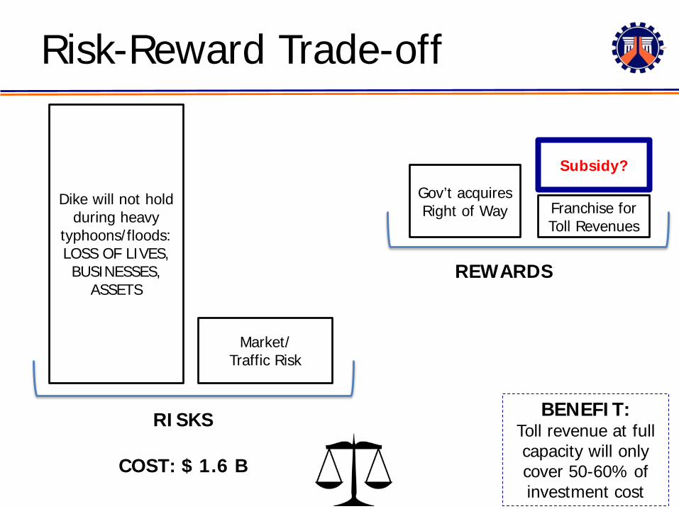
Risk-Reward Trade-off
Dike will not hold during heavy
typhoons/floods: LOSS OF LIVES, BUSINESSES,
ASSETS
RISKS
REWARDS
Market/Traffic Risk
Franchise for Toll Revenues
COST: $ 1.6 B
Gov’t acquires Right of Way
BENEFIT: Toll revenue at full capacity will only cover 50-60% of investment cost
Subsidy?
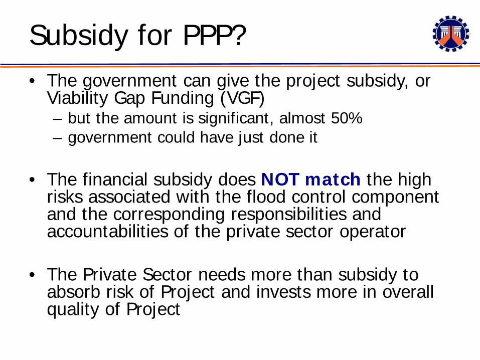
Subsidy for PPP?• The government can give the project subsidy, or
Viability Gap Funding (VGF) – but the amount is significant, almost 50%– government could have just done it
• The financial subsidy does NOT match the high risks associated with the flood control component and the corresponding responsibilities and accountabilities of the private sector operator
• The Private Sector needs more than subsidy to absorb risk of Project and invests more in overall quality of Project
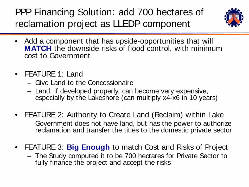
PPP Financing Solution: add 700 hectares of reclamation project as LLEDP component
• Add a component that has upside-opportunities that will MATCH the downside risks of flood control, with minimum cost to Government
• FEATURE 1: Land– Give Land to the Concessionaire– Land, if developed properly, can become very expensive,
especially by the Lakeshore (can multiply x4-x6 in 10 years)
• FEATURE 2: Authority to Create Land (Reclaim) within Lake– Government does not have land, but has the power to authorize
reclamation and transfer the titles to the domestic private sector
• FEATURE 3: Big Enough to match Cost and Risks of Project– The Study computed it to be 700 hectares for Private Sector to
fully finance the project and accept the risks
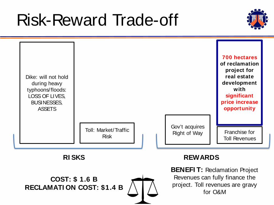
Risk-Reward Trade-off
Dike: will not hold during heavy
typhoons/floods: LOSS OF LIVES, BUSINESSES,
ASSETS
RISKS REWARDS
Toll: Market/Traffic Risk
COST: $ 1.6 BRECLAMATION COST: $1.4 B
Gov’t acquires Right of Way
BENEFIT: Reclamation Project Revenues can fully finance the project. Toll revenues are gravy
for O&M
Franchise for Toll Revenues
700 hectares of reclamation
project for real estate
development with
significant price increase opportunity
TAGUIG
BICUTAN
SUCAT
MUNTINLUPA
SAN PEDRO
BINAN-STA. ROSA
CABUYAO I
CABUYAO II
CALAMBA
LOS BANOS
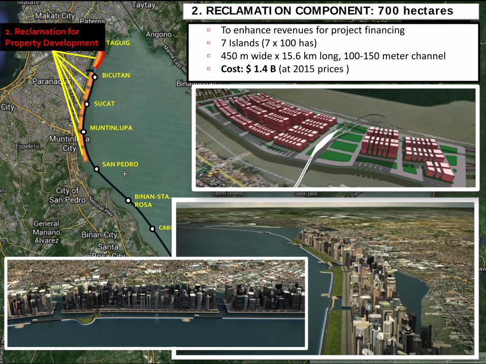
2. Reclamation for Property Development
2. RECLAMATION COMPONENT: 700 hectares
To enhance revenues for project financing 7 Islands (7 x 100 has) 450 m wide x 15.6 km long, 100-150 meter channel Cost: $ 1.4 B (at 2015 prices )
TAGUIG
BICUTAN
SUCAT
MUNTINLUPA
SAN PEDRO
STA. ROSA
CABUYAO I
CABUYAO II
CALAMBA
LOS BANOS
1. Taguig- Los Banos
2. Reclamation for Property Development
C6 Phase 2
Laguna Lakeshore Expressway- Dike Project (LLEDP)
TAGUIG
BICUTAN
SUCAT
MUNTINLUPA
SAN PEDRO
STA. ROSA
CABUYAO I
CABUYAO II
CALAMBA
LOS BANOS
1. Taguig- Los Banos
2. Reclamation for Property Development
C6 Phase 2 COMPONENTS1. Expressway-Dike: 47
kms (2x3 Lanes) 500 meters away from
shoreline Taguig to Los Banos 8 Interchanges 16 Bridges, 16 pumping
stations Elevation 15.2 m (100-Year
flood level) $ 1.6 B (at 2015 prices)
2. Reclamation: 700 hectares To enhance revenues for
project financing 7 Islands (7 x 100 has) 450 m wide x 15.6 km long 100-150 meter channel $ 1.4 B (at 2015 prices )
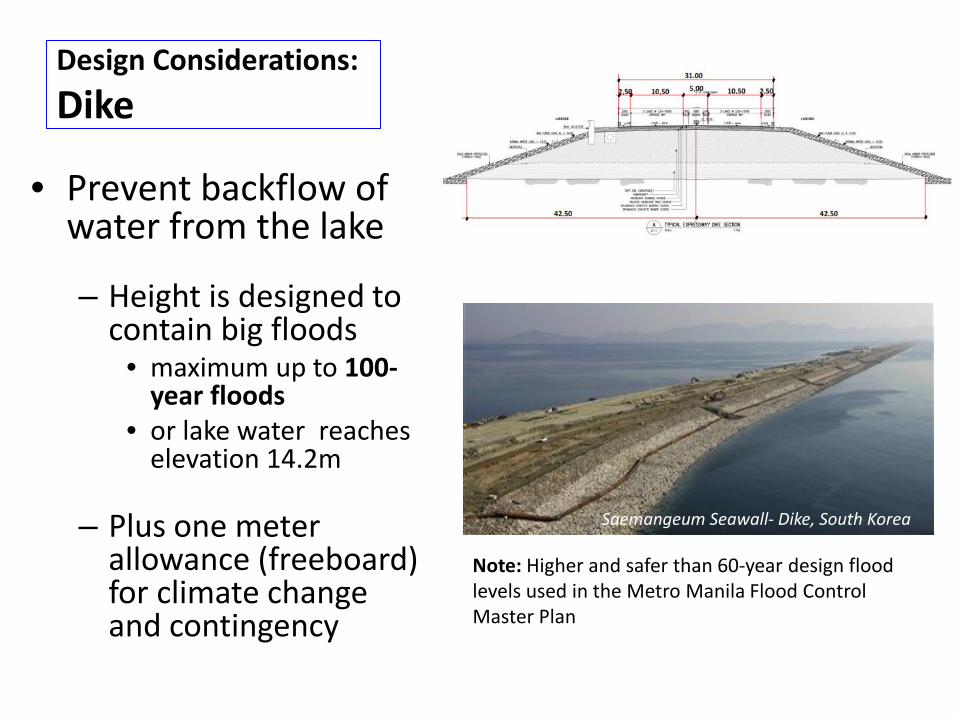
• Prevent backflow of water from the lake
– Height is designed to contain big floods
• maximum up to 100-year floods
• or lake water reaches elevation 14.2m
– Plus one meter allowance (freeboard) for climate change and contingency
Note: Higher and safer than 60-year design flood levels used in the Metro Manila Flood Control Master Plan
Saemangeum Seawall- Dike, South Korea
Design Considerations:Dike
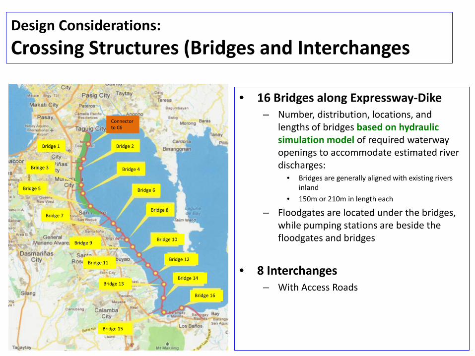
• 16 Bridges along Expressway-Dike– Number, distribution, locations, and
lengths of bridges based on hydraulic simulation model of required waterway openings to accommodate estimated river discharges:
• Bridges are generally aligned with existing rivers inland
• 150m or 210m in length each
– Floodgates are located under the bridges, while pumping stations are beside the floodgates and bridges
• 8 Interchanges– With Access Roads
Saemangeum Seawall- Dike, South Korea
Bridge 2
Bridge 4
Bridge 6
Bridge 8
Bridge 10
Bridge 12
Bridge 14
Bridge 16
Bridge 15
Bridge 13
Bridge 11
Bridge 9
Bridge 7
Bridge 5
Bridge 3
Bridge 1
Connector to C6
Design Considerations:Crossing Structures (Bridges and Interchanges
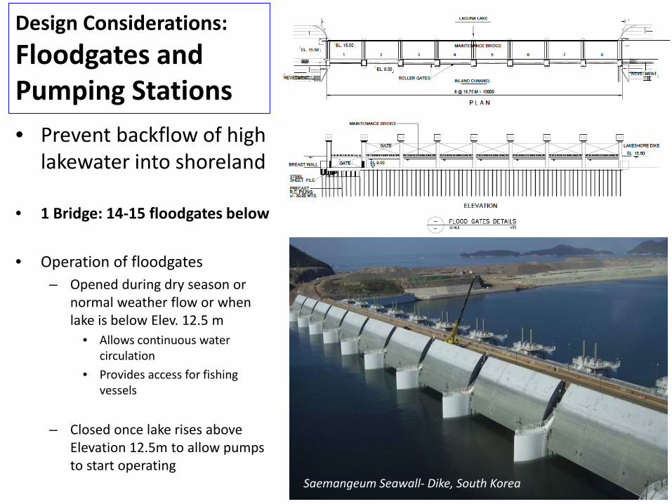
Design Considerations:Floodgates and Pumping Stations
Saemangeum Seawall- Dike, South Korea
• Prevent backflow of high lakewater into shoreland
• 1 Bridge: 14-15 floodgates below
• Operation of floodgates– Opened during dry season or
normal weather flow or when lake is below Elev. 12.5 m
• Allows continuous water circulation
• Provides access for fishing vessels
– Closed once lake rises above Elevation 12.5m to allow pumps to start operating
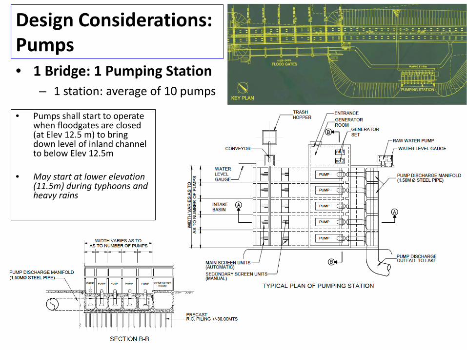
Design Considerations: Pumps
• Pumps shall start to operate when floodgates are closed (at Elev 12.5 m) to bring down level of inland channel to below Elev 12.5m
• May start at lower elevation (11.5m) during typhoons and heavy rains
• 1 Bridge: 1 Pumping Station – 1 station: average of 10 pumps
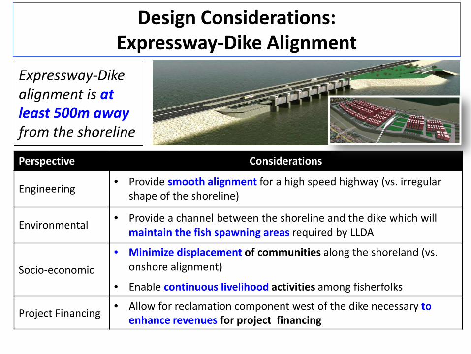
Expressway-Dike alignment is at least 500m away from the shoreline
Design Considerations:Expressway-Dike Alignment
Perspective Considerations
Engineering • Provide smooth alignment for a high speed highway (vs. irregular shape of the shoreline)
Environmental • Provide a channel between the shoreline and the dike which willmaintain the fish spawning areas required by LLDA
Socio-economic• Minimize displacement of communities along the shoreland (vs.
onshore alignment)
• Enable continuous livelihood activities among fisherfolks
Project Financing • Allow for reclamation component west of the dike necessary to enhance revenues for project financing
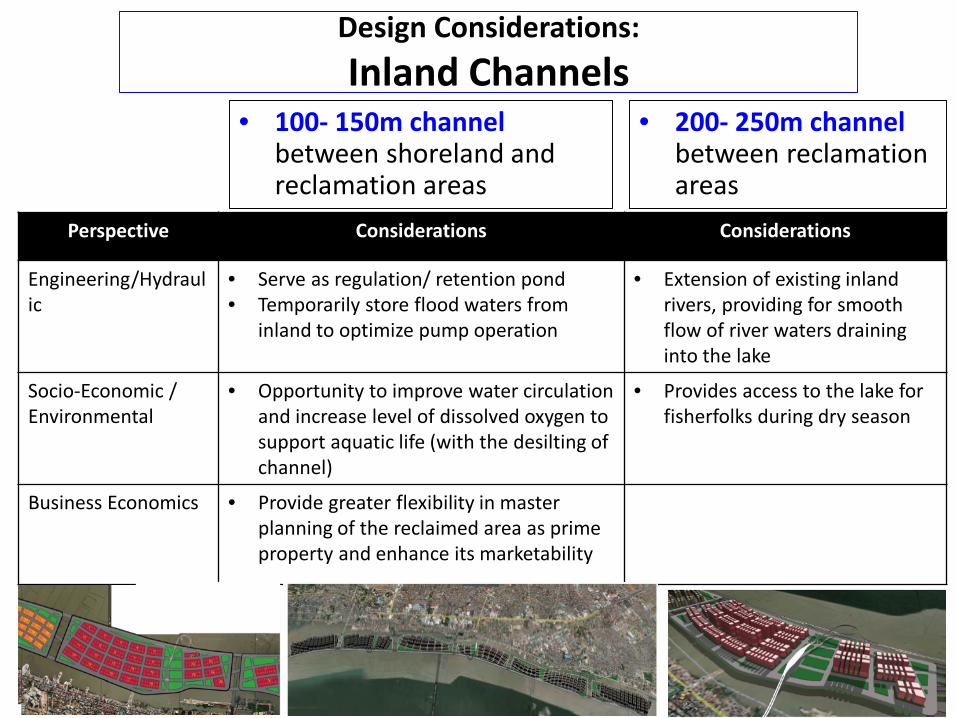
• 100- 150m channel between shoreland and reclamation areas
Perspective Considerations Considerations
Engineering/Hydraulic
• Serve as regulation/ retention pond• Temporarily store flood waters from
inland to optimize pump operation
• Extension of existing inland rivers, providing for smooth flow of river waters draining into the lake
Socio-Economic / Environmental
• Opportunity to improve water circulation and increase level of dissolved oxygen to support aquatic life (with the desilting ofchannel)
• Provides access to the lake for fisherfolks during dry season
Business Economics • Provide greater flexibility in master planning of the reclaimed area as prime property and enhance its marketability
• 200- 250m channel between reclamation areas
Design Considerations:Inland Channels
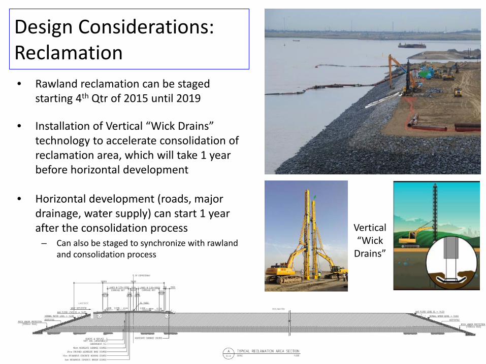
Design Considerations: Reclamation• Rawland reclamation can be staged
starting 4th Qtr of 2015 until 2019
• Installation of Vertical “Wick Drains” technology to accelerate consolidation of reclamation area, which will take 1 year before horizontal development
• Horizontal development (roads, major drainage, water supply) can start 1 year after the consolidation process
– Can also be staged to synchronize with rawlandand consolidation process
Vertical “Wick
Drains”
Benefits of the LLEDP• Flood Control
• Protection of Lives and Properties• Increased Real Estate Value• Embankment structure will enhance aquatic habitat in the lake
• Expressway• Reduced travel time• Reduced travel costs• Easing Manila South Road, SLEX, and integrates with C6 to
decongest Manila, alternative to EDSA in connecting SLEX and NLEX
• Reclamation• Prime Land Asset Created Value• Ease Metro Congestion due to expansion of business areas
• Employment: 403,613 jobs (OR 32,140,584 man-days)
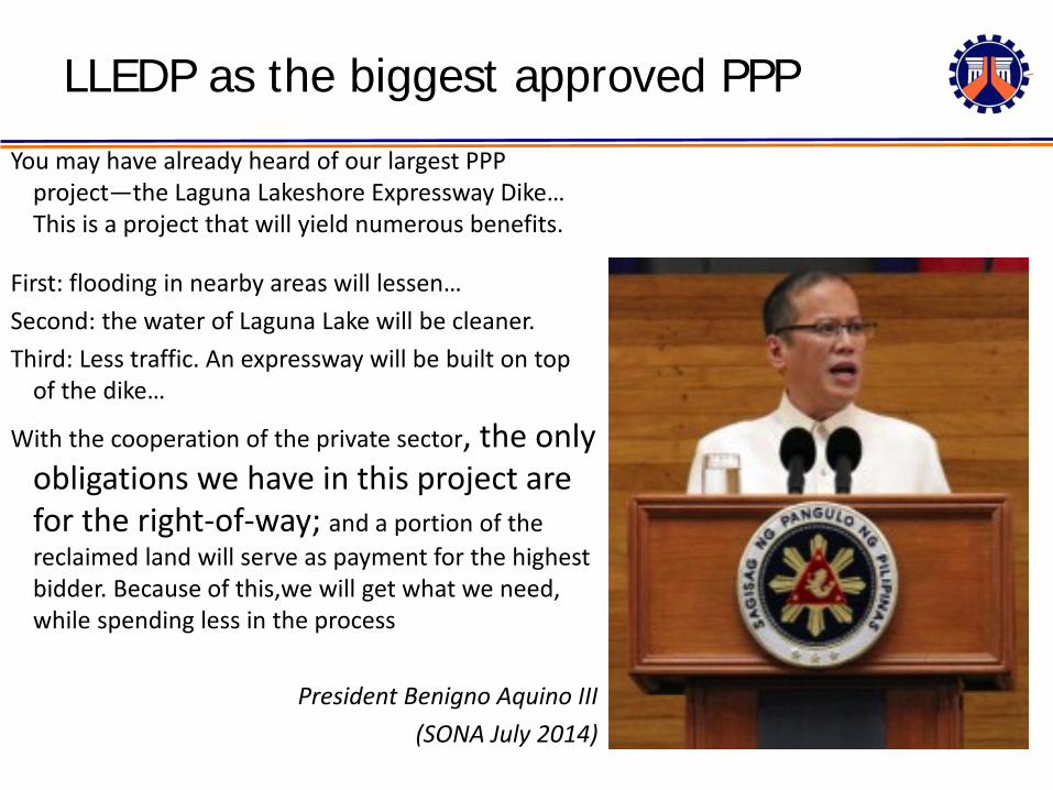
LLEDP as the biggest approved PPP
You may have already heard of our largest PPP project—the Laguna Lakeshore Expressway Dike… This is a project that will yield numerous benefits.
First: flooding in nearby areas will lessen…Second: the water of Laguna Lake will be cleaner. Third: Less traffic. An expressway will be built on top
of the dike…
With the cooperation of the private sector, the only obligations we have in this project are for the right-of-way; and a portion of the reclaimed land will serve as payment for the highest bidder. Because of this,we will get what we need, while spending less in the process
President Benigno Aquino III (SONA July 2014)
PPP Arrangement• Main Implementing Agency: DPWH
– ROW Delivery, DED Approval. Construction Supervision, Coordination with TRB for Toll Operation Certificate and Toll Rates/Adjustments, Expressway-Dike O&M Supervision
• Cooperating Agency for Reclamation: LLDA– Grant of Authority to Reclaim, Titling of Reclaimed Land
• Concessionaire:– designs, finances and builds expressway- dike and reclamation– transfers expressway-dike to DPWH, and operates it as toll
facility for 30 years, including flood control– transfers reclaimed land to LLDA, but receives title of portions
of reclaimed land as contract payment per Sec. 6 of BOT Law.
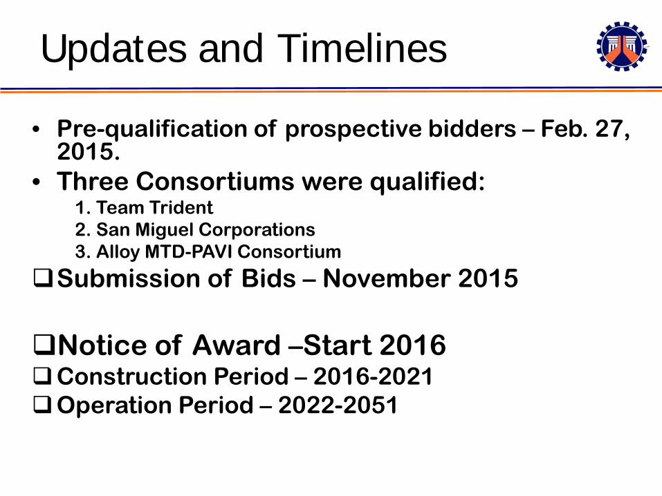
• Pre-qualification of prospective bidders – Feb. 27, 2015.
• Three Consortiums were qualified: 1. Team Trident2. San Miguel Corporations3. Alloy MTD-PAVI Consortium
Submission of Bids – November 2015
Notice of Award –Start 2016Construction Period – 2016-2021Operation Period – 2022-2051
Updates and Timelines
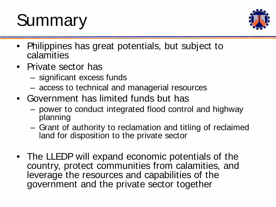
Summary• Philippines has great potentials, but subject to
calamities• Private sector has
– significant excess funds – access to technical and managerial resources
• Government has limited funds but has– power to conduct integrated flood control and highway
planning– Grant of authority to reclamation and titling of reclaimed
land for disposition to the private sector
• The LLEDP will expand economic potentials of the country, protect communities from calamities, and leverage the resources and capabilities of the government and the private sector together
Thank you very much.