Embed Size (px)
Citation preview
Livermore Active Transportation Plan: Matrix of Public Comments Received By 5/8/2017
Public comments have been received on the Livermore Active Transportation Plan from a variety of
sources, including: two open house workshops, eight pop‐up outreach events, a user survey, an online
wikimap, project website, and emails to the project team.
The online survey and wikimap comments are documented in Appendix B of Working Paper #1, which is
included in the August 25th ATPAC Meeting Agenda on the project website.
Comments from Workshop 1 and all other outreach received before May 8, 2017 are listed in the table
that follows. These comments from the public have been considered, to the extent appropriate and
feasible, in drafting the Active Transportation Plan working papers and will be incorporated into the
Draft and Final Plans. Key themes were developed from these public comments, as well as planning
commission and city council feedback, to guide the bicycle, pedestrian and trail recommendations in
Working Paper #3.
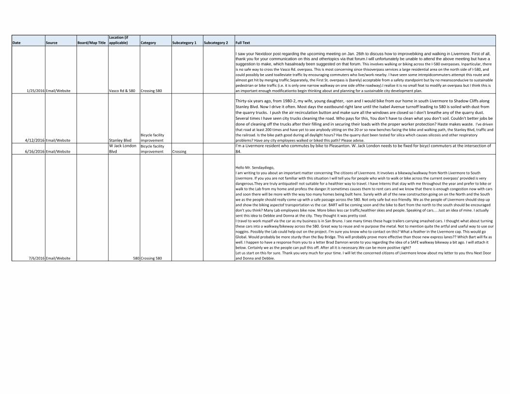
Date Source Board/Map TitleLocation (if applicable) Category Subcategory 1 Subcategory 2 Full Text
1/25/2016 Email/Website Vasco Rd & 580 Crossing 580
I saw your Nextdoor post regarding the upcoming meeting on Jan. 26th to discuss how to improvebiking and walking in Livermore. First of all, thank you for your communication on this and othertopics via that forum.I will unfortunately be unable to attend the above meeting but have a suggestion to make, which hasalready been suggested on that forum. This involves walking or biking across the I‐580 overpasses. Inparticular, there is no safe way to cross the Vasco Rd. overpass. This is most concerning since thisoverpass services a large residential area on the north side of I‐580, and
could possibly be used toalleviate traffic by encouraging commuters who live/work nearby. I have seen some intrepidcommuters attempt this route and
almost get hit by merging traffic.Separately, the First St. overpass is (barely) acceptable from a safety standpoint but by no meansconducive to sustainable
pedestrian or bike traffic (i.e. it is only one narrow walkway on one side ofthe roadway).I realize it is no small feat to modify an overpass but I think this is
an important enough modificationto begin thinking about and planning for a sustainable city development plan.
4/12/2016 Email/Website Stanley BlvdBicycle facility
improvement
Thirty‐six years ago, from 1980‐2, my wife, young daughter, ‐son and I would bike from our home in south Livermore to Shadow Cliffs along
Stanley Blvd. Now I drive it often. Most days the eastbound right lane until the Isabel Avenue turnoff leading to 580 is soiled with dust from
the quarry trucks. I push the air recirculation button and make sure all the windows are closed so I don't breathe any of the quarry dust.
Several times I have seen city trucks cleaning the road. Who pays for this, You don't have to clean what you don't soil. Couldn't better jobs be
done of cleaning off the trucks after their filling and in securing their loads with the proper worker protection? Haste makes waste. I've driven that road at least 200 times and have yet to see anybody sitting on the 20 or so new benches facing the bike and walking path, the Stanley Blvd, traffic and
the railroad. Is the bike path good during all daylight hours? Has the quarry dust been tested for silica which causes silicosis and other respiratory
problems? Have any city employees walked or biked this path? Please advise.
6/16/2016 Email/Website
W Jack London
BlvdBicycle facility
improvement Crossing
I'm a Livermore resident who commutes by bike to Pleasanton. W. Jack London needs to be fixed for bicycl commuters at the intersection of
84.
7/6/2016 Email/Website 580 Crossing 580
Hello Mr. Sendaydiego,
I am writing to you about an important matter concerning The citizens of Livermore. It involves a bikeway/walkway from North Livermore to South
Livermore. If you you are not familiar with this situation I will tell you for people who wish to walk or bike across the current overpass' provided is very
dangerous.They are truly antiquated! not suitable for a healthier way to travel. I have Interns that stay with me throughout the year and prefer to bike or
walk to the Lab from my home and profess the danger.It sometimes causes them to rent cars and we know that there is enough congestion now with cars
and soon there will be more with the way too many homes being built here. Surely with all of the new construction going on on the North and the South
we as the people should really come up with a safe passage across the 580. Not only safe but eco friendly. We as the people of Livermore should step up
and show the biking aspectof transportation vs the car. BART will be coming soon and the bike to Bart from the north to the south should be encouraged
don't you think? Many Lab employees bike now. More bikes less car traffic,healthier skies and people. Speaking of cars.... Just an idea of mine. I actually
sent this idea to Debbie and Donna at the city. They thought it was pretty cool.
I travel to work myself via the car as my business is in San Bruno. I see many times these huge trailers carrying smashed cars. I thought what about turning
these cars into a walkway/bikeway across the 580. Great way to reuse and re purpose the metal. Not to mention quite the artful and useful way to use our
noggins. Possibly the Lab could help out on the project. I'm sure you know who to contact on this? What a feather in the Livermore cap. This would go
Global. Would probably be more sturdy than the Bay Bridge. This will probably prove more effective than those new express lanes?? Which Bart will fix as
well. I happen to have a response from you to a letter Brad Damron wrote to you regarding the idea of a SAFE walkway bikeway a bit ago. I will attach it
below. Certainly we as the people can pull this off. After all it is necessary.We can be more positive right?
Let us start on this for sure. Thank you very much for your time. I will let the concerned citizens of Livermore know about my letter to you thru Next Door
and Donna and Debbie.
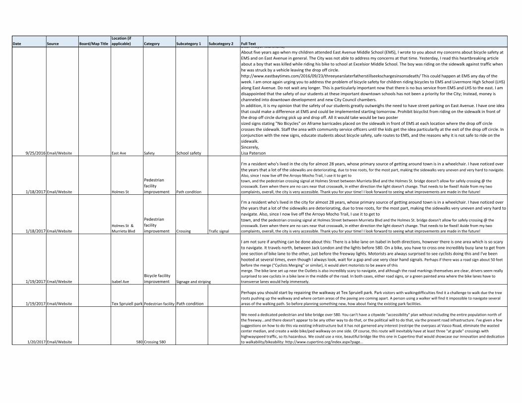
Date Source Board/Map TitleLocation (if applicable) Category Subcategory 1 Subcategory 2 Full Text
9/25/2016 Email/Website East Ave Safety School safety
Dear Mayor Marchand,
About five years ago when my children attended East Avenue Middle School (EMS), I wrote to you about my concerns about bicycle safety at
EMS and on East Avenue in general. The City was not able to address my concerns at that time. Yesterday, I read this heartbreaking article
about a boy that was killed while riding his bike to school at Excelsior Middle School. The boy was riding on the sidewalk against traffic when
he was struck by a vehicle leaving the drop off circle.
http://www.eastbaytimes.com/2016/09/23/threeyearslaterfatherstillseekschargesinsonsdeath/ This could happen at EMS any day of the
week. I am once again urging you to address the problem of bicycle safety for children riding bicycles to EMS and Livermore High School (LHS)
along East Avenue. Do not wait any longer. This is particularly important now that there is no bus service from EMS and LHS to the east. I am
disappointed that the safety of our students at these important downtown schools has not been a priority for the City; Instead, money is
channeled into downtown development and new City Council chambers.
In addition, it is my opinion that the safety of our students greatly outweighs the need to have street parking on East Avenue. I have one idea
that could make a difference at EMS and could be implemented starting tomorrow. Prohibit bicyclist from riding on the sidewalk in front of
the drop off circle during pick up and drop off. All it would take would be two poster
sized signs stating "No Bicycles" on Aframe barricades placed on the sidewalk in front of EMS at each location where the drop off circle
crosses the sidewalk. Staff the area with community service officers until the kids get the idea particularlly at the exit of the drop off circle. In
conjunction with the new signs, educate students about bicycle safety, safe routes to EMS, and the reasons why it is not safe to ride on the
sidewalk.
Sincerely,
Lisa Paterson
1/18/2017 Email/Website Holmes St
Pedestrian
facility
improvement Path condition
I'm a resident who's lived in the city for almost 28 years, whose primary source of getting around town is in a wheelchair. I have noticed over
the years that a lot of the sidewalks are deteriorating, due to tree roots, for the most part, making the sidewalks very uneven and very hard to navigate.
Also, since I now live off the Arroyo Mocho Trail, I use it to get to
town, and the pedestrian crossing signal at Holmes Street between Murrieta Blvd and the Holmes St. bridge doesn't allow for safely crossing @ the
crosswalk. Even when there are no cars near that crosswalk, in either direction the light doesn't change. That needs to be fixed! Aside from my two
complaints, overall, the city is very accessible. Thank you for your time! I look forward to seeing what improvements are made in the future!
1/18/2017 Email/Website
Holmes St &
Murrieta Blvd
Pedestrian
facility
improvement Crossing Trafic signal
I'm a resident who's lived in the city for almost 28 years, whose primary source of getting around town is in a wheelchair. I have noticed over
the years that a lot of the sidewalks are deteriorating, due to tree roots, for the most part, making the sidewalks very uneven and very hard to
navigate. Also, since I now live off the Arroyo Mocho Trail, I use it to get to
town, and the pedestrian crossing signal at Holmes Street between Murrieta Blvd and the Holmes St. bridge doesn't allow for safely crossing @ the
crosswalk. Even when there are no cars near that crosswalk, in either direction the light doesn't change. That needs to be fixed! Aside from my two
complaints, overall, the city is very accessible. Thank you for your time! I look forward to seeing what improvements are made in the future!
1/19/2017 Email/Website Isabel Ave
Bicycle facility
improvement Signage and striping
I am not sure if anything can be done about this: There is a bike lane on Isabel in both directions, however there is one area which is so scary
to navigate. It travels north, between Jack London and the lights before 580. On a bike, you have to cross one incredibly busy lane to get from
one section of bike lane to the other, just before the freeway lights. Motorists are always surprised to see cyclists doing this and I've been
hooted at several times, even though I always look, wait for a gap and use very clear hand signals. Perhaps if there was a road sign about 50 feet before the merge ("Cyclists Merging" or similar), it would alert motorists to be aware of this
merge. The bike lane set up near the Outlets is also incredibly scary to navigate, and although the road markings themselves are clear, drivers seem really
surprised to see cyclists in a bike lane in the middle of the road. In both cases, either road signs, or a green painted area where the bike lanes have to
transverse lanes would help immensely.
1/19/2017 Email/Website Tex Spruiell park Pedestrian facility Path condition
Perhaps you should start by repairing the walkway at Tex Spruiell park. Park visitors with walkingdifficulties find it a challenge to walk due the tree roots pushing up the walkway and where certain areas of the paving are coming apart. A person using a walker will find it impossible to navigate several
areas of the walking path. So before planning something new, how about fixing the existing park facilities.
1/20/2017 Email/Website 580 Crossing 580
We need a dedicated pedestrian and bike bridge over 580. You can't have a citywide "accessibility" plan without including the entire population north of
the freeway...and there doesn't appear to be any other way to do that, or the political will to do that, via the present road infrastructure. I've given a few
suggestions on how to do this via existing infrastructure but it has not garnered any interest (restripe the overpass at Vasco Road, eliminate the wasted
center median, and create a wide bike/ped walkway on one side. Of course, this route will inevitably have at least three "at grade" crossings with
highwayspeed traffic, so its hazardous. We could use a nice, beautiful bridge like this one in Cupertino that would showcase our innovation and dedication
to walkability/bikeability: http://www.cupertino.org/index.aspx?page...
Date Source Board/Map TitleLocation (if applicable) Category Subcategory 1 Subcategory 2 Full Text
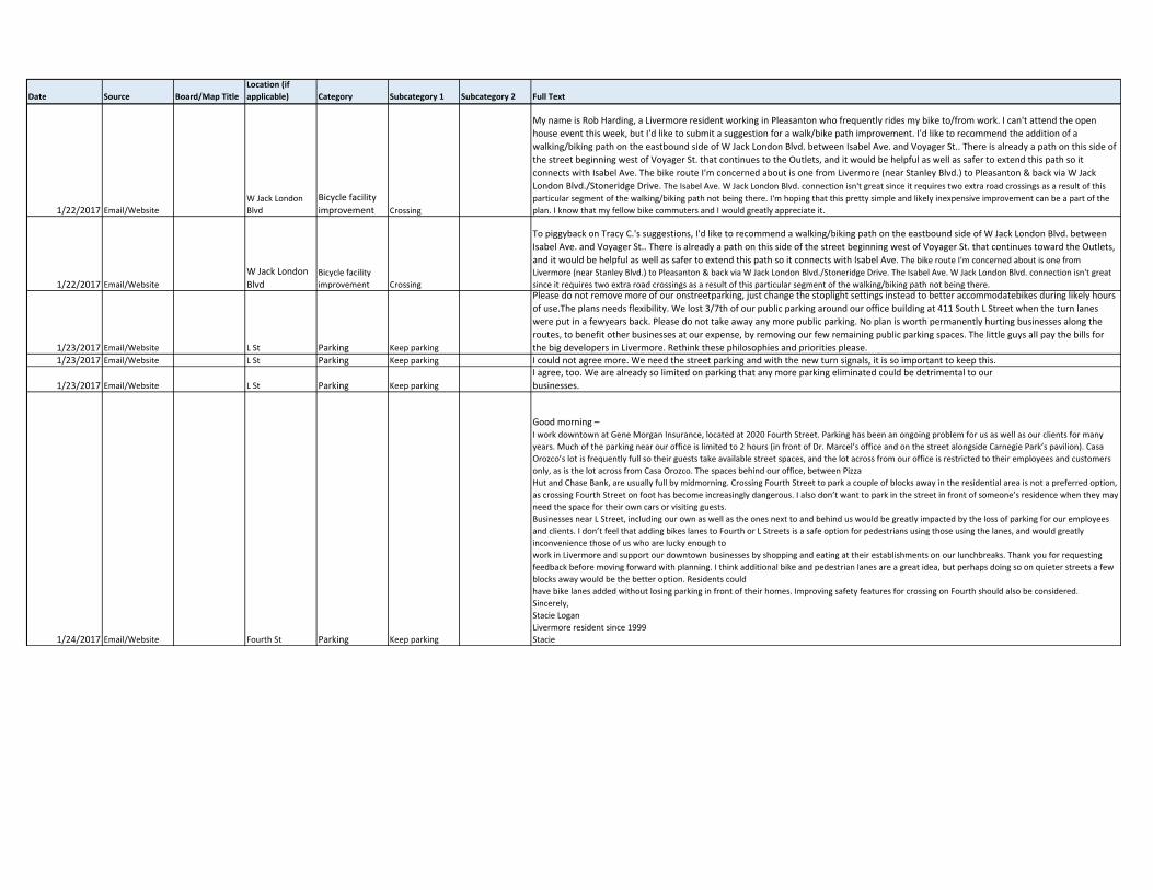
1/22/2017 Email/Website
W Jack London
Blvd
Bicycle facility
improvement Crossing
My name is Rob Harding, a Livermore resident working in Pleasanton who frequently rides my bike to/from work. I can't attend the open
house event this week, but I'd like to submit a suggestion for a walk/bike path improvement. I'd like to recommend the addition of a
walking/biking path on the eastbound side of W Jack London Blvd. between Isabel Ave. and Voyager St.. There is already a path on this side of
the street beginning west of Voyager St. that continues to the Outlets, and it would be helpful as well as safer to extend this path so it
connects with Isabel Ave. The bike route I'm concerned about is one from Livermore (near Stanley Blvd.) to Pleasanton & back via W Jack
London Blvd./Stoneridge Drive. The Isabel Ave. W Jack London Blvd. connection isn't great since it requires two extra road crossings as a result of this
particular segment of the walking/biking path not being there. I'm hoping that this pretty simple and likely inexpensive improvement can be a part of the
plan. I know that my fellow bike commuters and I would greatly appreciate it.
1/22/2017 Email/Website
W Jack London
BlvdBicycle facility
improvement Crossing
To piggyback on Tracy C.'s suggestions, I'd like to recommend a walking/biking path on the eastbound side of W Jack London Blvd. between
Isabel Ave. and Voyager St.. There is already a path on this side of the street beginning west of Voyager St. that continues toward the Outlets,
and it would be helpful as well as safer to extend this path so it connects with Isabel Ave. The bike route I'm concerned about is one from
Livermore (near Stanley Blvd.) to Pleasanton & back via W Jack London Blvd./Stoneridge Drive. The Isabel Ave. W Jack London Blvd. connection isn't great
since it requires two extra road crossings as a result of this particular segment of the walking/biking path not being there.
1/23/2017 Email/Website L St Parking Keep parking
Please do not remove more of our onstreetparking, just change the stoplight settings instead to better accommodatebikes during likely hours
of use.The plans needs flexibility. We lost 3/7th of our public parking around our office building at 411 South L Street when the turn lanes
were put in a fewyears back. Please do not take away any more public parking. No plan is worth permanently hurting businesses along the
routes, to benefit other businesses at our expense, by removing our few remaining public parking spaces. The little guys all pay the bills for
the big developers in Livermore. Rethink these philosophies and priorities please.1/23/2017 Email/Website L St Parking Keep parking I could not agree more. We need the street parking and with the new turn signals, it is so important to keep this.
1/23/2017 Email/Website L St Parking Keep parking
I agree, too. We are already so limited on parking that any more parking eliminated could be detrimental to our
businesses.
1/24/2017 Email/Website Fourth St Parking Keep parking
Good morning –I work downtown at Gene Morgan Insurance, located at 2020 Fourth Street. Parking has been an ongoing problem for us as well as our clients for many
years. Much of the parking near our office is limited to 2 hours (in front of Dr. Marcel’s office and on the street alongside Carnegie Park’s pavilion). Casa
Orozco’s lot is frequently full so their guests take available street spaces, and the lot across from our office is restricted to their employees and customers
only, as is the lot across from Casa Orozco. The spaces behind our office, between Pizza
Hut and Chase Bank, are usually full by midmorning. Crossing Fourth Street to park a couple of blocks away in the residential area is not a preferred option,
as crossing Fourth Street on foot has become increasingly dangerous. I also don’t want to park in the street in front of someone’s residence when they may
need the space for their own cars or visiting guests.
Businesses near L Street, including our own as well as the ones next to and behind us would be greatly impacted by the loss of parking for our employees
and clients. I don’t feel that adding bikes lanes to Fourth or L Streets is a safe option for pedestrians using those using the lanes, and would greatly
inconvenience those of us who are lucky enough to
work in Livermore and support our downtown businesses by shopping and eating at their establishments on our lunchbreaks. Thank you for requesting
feedback before moving forward with planning. I think additional bike and pedestrian lanes are a great idea, but perhaps doing so on quieter streets a few
blocks away would be the better option. Residents could
have bike lanes added without losing parking in front of their homes. Improving safety features for crossing on Fourth should also be considered.
Sincerely,
Stacie Logan
Livermore resident since 1999
Stacie
Date Source Board/Map TitleLocation (if applicable) Category Subcategory 1 Subcategory 2 Full Text
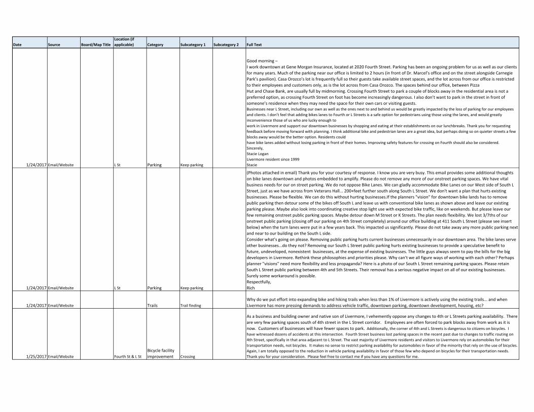
1/24/2017 Email/Website L St Parking Keep parking
Good morning –
I work downtown at Gene Morgan Insurance, located at 2020 Fourth Street. Parking has been an ongoing problem for us as well as our clients
for many years. Much of the parking near our office is limited to 2 hours (in front of Dr. Marcel’s office and on the street alongside Carnegie
Park’s pavilion). Casa Orozco’s lot is frequently full so their guests take available street spaces, and the lot across from our office is restricted
to their employees and customers only, as is the lot across from Casa Orozco. The spaces behind our office, between Pizza
Hut and Chase Bank, are usually full by midmorning. Crossing Fourth Street to park a couple of blocks away in the residential area is not a
preferred option, as crossing Fourth Street on foot has become increasingly dangerous. I also don’t want to park in the street in front of
someone’s residence when they may need the space for their own cars or visiting guests.Businesses near L Street, including our own as well as the ones next to and behind us would be greatly impacted by the loss of parking for our employees
and clients. I don’t feel that adding bikes lanes to Fourth or L Streets is a safe option for pedestrians using those using the lanes, and would greatly
inconvenience those of us who are lucky enough to
work in Livermore and support our downtown businesses by shopping and eating at their establishments on our lunchbreaks. Thank you for requesting
feedback before moving forward with planning. I think additional bike and pedestrian lanes are a great idea, but perhaps doing so on quieter streets a few
blocks away would be the better option. Residents could
have bike lanes added without losing parking in front of their homes. Improving safety features for crossing on Fourth should also be considered.
Sincerely,
Stacie Logan
Livermore resident since 1999
Stacie
1/24/2017 Email/Website L St Parking Keep parking
(Photos attached in email) Thank you for your courtesy of response. I know you are very busy. This email provides some additional thoughts
on bike lanes downtown and photos embedded to amplify. Please do not remove any more of our onstreet parking spaces. We have vital
business needs for our on street parking. We do not oppose Bike Lanes. We can gladly accommodate Bike Lanes on our West side of South L
Street, just as we have across from Veterans Hall... 200+feet further south along South L Street. We don't want a plan that hurts existing
businesses. Please be flexible. We can do this without hurting businesses.If the planners "vision" for downtown bike lands has to remove
public parking then detour some of the bikes off South L and leave us with conventional bike lanes as shown above and leave our existing
parking please. Maybe also look into coordinating creative stop light use with expected bike traffic, like on weekends. But please leave our
few remaining onstreet public parking spaces. Maybe detour down M Street or K Streets. The plan needs flexibility. We lost 3/7ths of our
onstreet public parking (closing off our parking on 4th Street completely) around our office building at 411 South L Street (please see insert
below) when the turn lanes were put in a few years back. This impacted us significantly. Please do not take away any more public parking next
and near to our building on the South L side.
Consider what's going on please. Removing public parking hurts current businesses unnecessarily in our downtown area. The bike lanes serve
other businesses...do they not? Removing our South L Street public parking hurts existing businesses to provide a speculative benefit to
future, undeveloped, nonexistent businesses, at the expense of existing businesses. The little guys always seem to pay the bills for the big
developers in Livermore. Rethink these philosophies and priorities please. Why can't we all figure ways of working with each other? Perhaps
planner "visions" need more flexibility and less propaganda? Here is a photo of our South L Street remaining parking spaces. Please retain
South L Street public parking between 4th and 5th Streets. Their removal has a serious negative impact on all of our existing businesses.
Surely some workaround is possible.
Respectfully,
Rich
1/24/2017 Email/Website Trails Trail finding
Why do we put effort into expanding bike and hiking trails when less than 1% of Livermore is actively using the existing trails... and when
Livermore has more pressing demands to address vehicle traffic, downtown parking, downtown development, housing, etc?
1/25/2017 Email/Website Fourth St & L St
Bicycle facility
improvement Crossing
As a business and building owner and native son of Livermore, I vehemently oppose any changes to 4th or L Streets parking availability. There
are very few parking spaces south of 4th street in the L Street corridor. Employees are often forced to park blocks away from work as it is
now. Customers of businesses will have fewer spaces to park. Additionally, the corner of 4th and L Streets is dangerous to citizens on bicycles. I have witnessed dozens of accidents at this intersection. Fourth Street business lost parking spaces in the recent past due to changes to traffic routing on
4th Street, specifically in that area adjacent to L Street. The vast majority of Livermore residents and visitors to Livermore rely on automobiles for their
transportation needs, not bicycles. It makes no sense to restrict parking availability for automobiles in favor of the minority that rely on the use of bicycles.
Again, I am totally opposed to the reduction in vehicle parking availability in favor of those few who depend on bicycles for their transportation needs.
Thank you for your consideration. Please feel free to contact me if you have any questions for me.
Date Source Board/Map TitleLocation (if applicable) Category Subcategory 1 Subcategory 2 Full Text
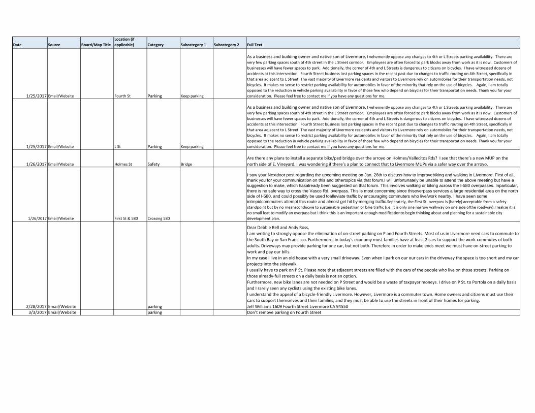
1/25/2017 Email/Website Fourth St Parking Keep parking
As a business and building owner and native son of Livermore, I vehemently oppose any changes to 4th or L Streets parking availability. There are
very few parking spaces south of 4th street in the L Street corridor. Employees are often forced to park blocks away from work as it is now. Customers of
businesses will have fewer spaces to park. Additionally, the corner of 4th and L Streets is dangerous to citizens on bicycles. I have witnessed dozens of
accidents at this intersection. Fourth Street business lost parking spaces in the recent past due to changes to traffic routing on 4th Street, specifically in
that area adjacent to L Street. The vast majority of Livermore residents and visitors to Livermore rely on automobiles for their transportation needs, not
bicycles. It makes no sense to restrict parking availability for automobiles in favor of the minority that rely on the use of bicycles. Again, I am totally
opposed to the reduction in vehicle parking availability in favor of those few who depend on bicycles for their transportation needs. Thank you for your
consideration. Please feel free to contact me if you have any questions for me.
1/25/2017 Email/Website L St Parking Keep parking
As a business and building owner and native son of Livermore, I vehemently oppose any changes to 4th or L Streets parking availability. There are
very few parking spaces south of 4th street in the L Street corridor. Employees are often forced to park blocks away from work as it is now. Customers of
businesses will have fewer spaces to park. Additionally, the corner of 4th and L Streets is dangerous to citizens on bicycles. I have witnessed dozens of
accidents at this intersection. Fourth Street business lost parking spaces in the recent past due to changes to traffic routing on 4th Street, specifically in
that area adjacent to L Street. The vast majority of Livermore residents and visitors to Livermore rely on automobiles for their transportation needs, not
bicycles. It makes no sense to restrict parking availability for automobiles in favor of the minority that rely on the use of bicycles. Again, I am totally
opposed to the reduction in vehicle parking availability in favor of those few who depend on bicycles for their transportation needs. Thank you for your
consideration. Please feel free to contact me if you have any questions for me.
1/26/2017 Email/Website Holmes St Safety Bridge
Are there any plans to install a separate bike/ped bridge over the arroyo on Holmes/Vallecitos Rds? I see that there’s a new MUP on the
north side of E. Vineyard. I was wondering if there’s a plan to connect that to Livermore MUPs via a safer way over the arroyo.
1/26/2017 Email/Website First St & 580 Crossing 580
I saw your Nextdoor post regarding the upcoming meeting on Jan. 26th to discuss how to improvebiking and walking in Livermore. First of all, thank you for your communication on this and othertopics via that forum.I will unfortunately be unable to attend the above meeting but have a suggestion to make, which hasalready been suggested on that forum. This involves walking or biking across the I-580 overpasses. Inparticular, there is no safe way to cross the Vasco Rd. overpass. This is most concerning since thisoverpass services a large residential area on the north side of I-580, and could possibly be used toalleviate traffic by encouraging commuters who live/work nearby. I have seen some intrepidcommuters attempt this route and almost get hit by merging traffic.Separately, the First St. overpass is (barely) acceptable from a safety
standpoint but by no meansconducive to sustainable pedestrian or bike traffic (i.e. it is only one narrow walkway on one side ofthe roadway).I realize it is
no small feat to modify an overpass but I think this is an important enough modificationto begin thinking about and planning for a sustainable city
development plan.
2/28/2017 Email/Website parking
Dear Debbie Bell and Andy Ross,
I am writing to strongly oppose the elimination of on‐street parking on P and Fourth Streets. Most of us in Livermore need cars to commute to
the South Bay or San Francisco. Furthermore, in today's economy most families have at least 2 cars to support the work‐commutes of both
adults. Driveways may provide parking for one car, but not both. Therefore in order to make ends meet we must have on‐street parking to
work and pay our bills.
In my case I live in an old house with a very small driveway. Even when I park on our our cars in the driveway the space is too short and my car
projects into the sidewalk.
I usually have to park on P St. Please note that adjacent streets are filled with the cars of the people who live on those streets. Parking on
those already‐full streets on a daily basis is not an option.
Furthermore, new bike lanes are not needed on P Street and would be a waste of taxpayer moneys. I drive on P St. to Portola on a daily basis
and I rarely seen any cyclists using the existing bike lanes.
I understand the appeal of a bicycle‐friendly Livermore. However, Livermore is a commuter town. Home owners and citizens must use their
cars to support themselves and their families, and they must be able to use the streets in front of their homes for parking.
Jeff Williams 1609 Fourth Street Livermore CA 94550
3/3/2017 Email/Website parking Don’t remove parking on Fourth Street
Date Source Board/Map TitleLocation (if applicable) Category Subcategory 1 Subcategory 2 Full Text
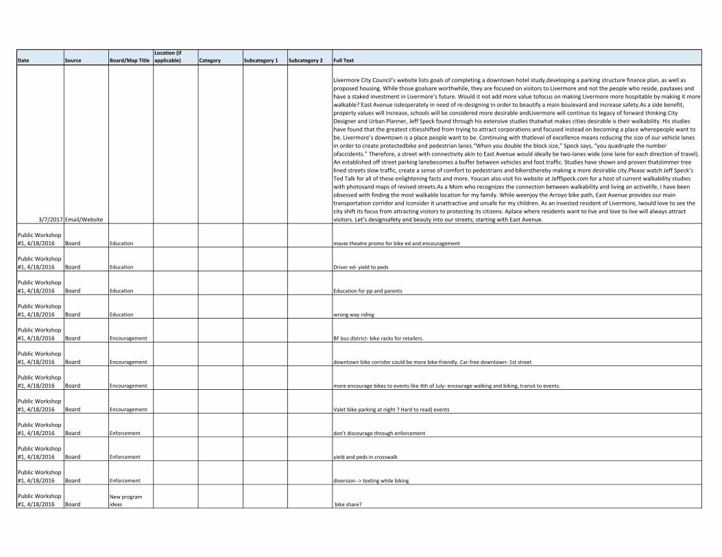
3/7/2017 Email/Website
Livermore City Council’s website lists goals of completing a downtown hotel study,developing a parking structure finance plan, as well as
proposed housing. While those goalsare worthwhile, they are focused on visitors to Livermore and not the people who reside, paytaxes and
have a staked investment in Livermore’s future. Would it not add more value tofocus on making Livermore more hospitable by making it more
walkable? East Avenue isdesperately in need of re‐designing in order to beautify a main boulevard and increase safety.As a side benefit,
property values will increase, schools will be considered more desirable andLivermore will continue its legacy of forward thinking.City
Designer and Urban Planner, Jeff Speck found through his extensive studies thatwhat makes cities desirable is their walkability. His studies
have found that the greatest citiesshifted from trying to attract corporations and focused instead on becoming a place wherepeople want to
be. Livermore’s downtown is a place people want to be. Continuing with thatlevel of excellence means reducing the size of our vehicle lanes
in order to create protectedbike and pedestrian lanes.“When you double the block size,” Speck says, “you quadruple the number
ofaccidents.” Therefore, a street with connectivity akin to East Avenue would ideally be two‐lanes wide (one lane for each direction of travel).
An established off street parking lanebecomes a buffer between vehicles and foot traffic. Studies have shown and proven thatslimmer tree
lined streets slow traffic, create a sense of comfort to pedestrians and bikersthereby making a more desirable city.Please watch Jeff Speck’s
Ted Talk for all of these enlightening facts and more. Youcan also visit his website at JeffSpeck.com for a host of current walkability studies
with photosand maps of revised streets.As a Mom who recognizes the connection between walkability and living an activelife, I have been
obsessed with finding the most walkable location for my family. While weenjoy the Arroyo bike path, East Avenue provides our main
transportation corridor and Iconsider it unattractive and unsafe for my children. As an invested resident of Livermore, Iwould love to see the
city shift its focus from attracting visitors to protecting its citizens. Aplace where residents want to live and love to live will always attract
visitors. Let’s designsafety and beauty into our streets, starting with East Avenue.
Public Workshop
#1, 4/18/2016 Board Education movie theatre promo for bike ed and encouragement
Public Workshop
#1, 4/18/2016 Board Education Driver ed‐ yield to peds
Public Workshop
#1, 4/18/2016 Board Education Education for pp and parents
Public Workshop
#1, 4/18/2016 Board Education wrong way riding
Public Workshop
#1, 4/18/2016 Board Encouragement BF bus district‐ bike racks for retailers.
Public Workshop
#1, 4/18/2016 Board Encouragement downtown bike corridor could be more bike‐friendly. Car‐free downtown‐ 1st street
Public Workshop
#1, 4/18/2016 Board Encouragement more encourage bikes to events like 4th of July‐ encourage walking and biking, transit to events.
Public Workshop
#1, 4/18/2016 Board Encouragement Valet bike parking at night ? Hard to read) events
Public Workshop
#1, 4/18/2016 Board Enforcement don't discourage through enforcement
Public Workshop
#1, 4/18/2016 Board Enforcement yield and peds in crosswalk
Public Workshop
#1, 4/18/2016 Board Enforcement diversion‐‐> texting while biking
Public Workshop
#1, 4/18/2016 BoardNew program
ideas bike share?
Date Source Board/Map TitleLocation (if applicable) Category Subcategory 1 Subcategory 2 Full Text
Public Workshop
#1, 4/18/2016 BoardNew program
ideas bike share should be on righ side of bike lane more street sweeping necessary
Public Workshop
#1, 4/18/2016 BoardNew program
ideas app for maintenance issue
Public Workshop
#1, 4/18/2016 BoardNew program
ideas limit raised pavement marking
Public Workshop
#1, 4/18/2016 BoardNew program
ideas trash bins in bike lanes
Public Workshop
#1, 4/18/2016 BoardNew program
ideas standards for construction zones bike lanes, bike diversion
Public Workshop
#1, 4/18/2016 BoardNew program
ideas mobile‐led sign‐ bike safety messages
Public Workshop
#1, 4/18/2016 BoardNew program
ideas count program‐ walk and bike
Public Workshop
#1, 4/18/2016 BoardNew program
ideas Equity‐providing coverage to all neighborhoods
Public Workshop
#1, 4/18/2016 Board
Network
connectivity and
design *scenic routes, better design so bad behaviors (wrong‐way riding) aren't necessary
Public Workshop
#1, 4/18/2016 Board
Network
connectivity and
design design for families
Public Workshop
#1, 4/18/2016 Board
Network
connectivity and
design bollard design, lsck of ramps and design for cargo
Public Workshop
#1, 4/18/2016 Board
Network
connectivity and
design uncontrolled crossing and sight line issues
Public Workshop
#1, 4/18/2016 Board
Network
connectivity and
design parking lots
Public Workshop
#1, 4/18/2016 Board
Network
connectivity and
design ped xings at bus stops‐ priority ped crossingat schools, libraries, parks, grocery stores, community college
Public Workshop
#1, 4/18/2016 Board
Planning and
interagency
coordination very important
Public Workshop
#1, 4/18/2016 Board
Planning and
interagency
coordination Better connections to North Livermore ‐‐‐ e.g. crossings ove I‐580 at Vasco, First St.
Public Workshop
#1, 4/18/2016 Board
Planning and
interagency
coordination Surveying usage of existing trails during week and weekend as well as over time
Public Workshop
#1, 4/18/2016 Board Support facilities need water fountains for drinking
Date Source Board/Map TitleLocation (if applicable) Category Subcategory 1 Subcategory 2 Full Text
Public Workshop
#1, 4/18/2016 Board Support facilities bike parking needed downtown
Public Workshop
#1, 4/18/2016 BoardSafety education
and promotion encourage more families to walk and bike to school
Public Workshop
#1, 4/18/2016 BoardSafety education
and promotion student bike education
Public Workshop
#1, 4/18/2016 Board Maintenance sweeping debris out of bikeways
Public Workshop
#1, 4/18/2016 Board Maintenance need better maintenance, potholes
Public Workshop
#1, 4/18/2016 Board Maintenance more funding for trail maintenance
Public Workshop
#1, 4/18/2016 Board Maintenance avoid use of roundup on side of trails‐ save $ and environment
Public Workshop
#1, 4/18/2016 Board Implementation complete cycling lane on East Avenue
Public Workshop
#1, 4/18/2016 Board connections to and through downtown trailhead parking for cars‐ ba able to get anywhere
Public Workshop
#1, 4/18/2016 Board New goals close network gaps
Public Workshop
#1, 4/18/2016 Board New goals
complete network‐ bike
well‐connected and complete
Public Workshop
#1, 4/18/2016 Board New goals connect attractors like wineries
Public Workshop
#1, 4/18/2016 Board New goals become a bicycle‐friendly community‐ silver
Public Workshop
#1, 4/18/2016 Board New goals encourage bike mode share
Public Workshop
#1, 4/18/2016 Board New goals city should prioritize‐ intersection control for bikes and peds
Public Workshop
#1, 4/18/2016 Board New goals
safety as main goal
‐ community identity concerned
‐ identify suggested route to every school
Public Workshop
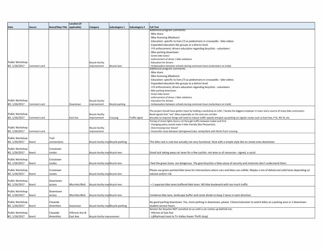
#2, 1/26/2017 Comment card
E Jack London
Blvd & Isabelle Rd Access Gap closure
This is fantastic. Thanks for the effort!!
‐ Gap closures, gap closures, gap closures!‐ East Jack @ Isabelle: short section on South side of Jack. Need to close that gap!
‐ Holmes to Vallecitos Bridge ‐ death trap. Need an alt or fix the bridge. Could close gap from the Sycamore Grove Trail across Vallecitos.
‐ Iron Horse along railway to cross city
‐ Fix existing underpasses along Arroyo Trail ‐ they flood and are unpassable and unlit!
Date Source Board/Map TitleLocation (if applicable) Category Subcategory 1 Subcategory 2 Full Text
Public Workshop
#2, 1/26/2017 Comment card Iron Horse Access
Cross town
connection
This is fantastic. Thanks for the effort!!
‐ Gap closures, gap closures, gap closures!
‐ East Jack @ Isabelle: short section on South side of Jack. Need to close that gap!
‐ Holmes to Vallecitos Bridge ‐ death trap. Need an alt or fix the bridge. Could close gap from the Sycamore Grove Trail across Vallecitos.‐ Iron Horse along railway to cross city
‐ Fix existing underpasses along Arroyo Trail ‐ they flood and are unpassable and unlit!
Public Workshop
#2, 1/26/2017 Comment card Third St Access Gap closure
1. SAFETY: For years, I drove to UNC from Stanley / Murrietta because cycling down East was noisy and dangerous... Mostly on home
commute West where cars would turn right onto cross streets, crossing the bike lane unaware of the 12 go 16 mph speeds of bikes. I found
getting to Almond Avenue entrance to bike path tricky ... often dismounting and using crosswalk. 2. GAP: Now retired, my main route is down Third Street bike route from Post Office/Downtown to Murietta / Diving area. Third Street path dumps me
either South to 4th Street traffic (no bike lane ... although wide enough) or north to 1st Street / Railroad maze (no bike lane and tricky to go north to reach
Railroad / Stanley stoplight). Once on Stanley, nice wide path.
3. I hate reaching dead end on Iron Horse blocking access to shopping center behind Heritage Estates. Tear down that wrought‐iron terminus and give us a
way to get to the shopping center.
Public Workshop
#2, 1/26/2017 Comment card Iron Horse Trail Access
Connection to
existing
destination or
facility
1. SAFETY: For years, I drove to UNC from Stanley / Murrietta because cycling down East was noisy and dangerous... Mostly on home
commute West where cars would turn right onto cross streets, crossing the bike lane unaware of the 12 go 16 mph speeds of bikes. I found
getting to Almond Avenue entrance to bike path tricky ... often dismounting and using crosswalk.
2. GAP: Now retired, my main route is down Third Street bike route from Post Office/Downtown to Murietta / Diving area. Third Street path
dumps me either South to 4th Street traffic (no bike lane ... although wide enough) or north to 1st Street / Railroad maze (no bike lane and
tricky to go north to reach Railroad / Stanley stoplight). Once on Stanley, nice wide path.3. I hate reaching dead end on Iron Horse blocking access to shopping center behind Heritage Estates. Tear down that wrought‐iron terminus and give us a
way to get to the shopping center.
Public Workshop
#2, 1/26/2017 Board
Proposed
recommendatio
ns map downtown Access
Cross town
connection Bicycle Access to downtown not around downtown
Public Workshop
#2, 1/26/2017 Board
Proposed
recommendatio
ns map Isabel Ave Access
Connection to
existing
destination or
facility Top priority. Isabel access to proposed BART. Jack London <‐‐> Airway
Public Workshop
#2, 1/26/2017 Board
Proposed
recommendatio
ns map Murietta Blvd Access
Connection to
existing
destination or
facility new Murrieta crosswalk between existing and railroad bridge to access bike path from Cardinal side of Murrieta
Public Workshop
#2, 1/26/2017 Board
Proposed
recommendatio
ns map Parkway Park Access
Connection to
existing
destination or
facility North/South bridge path at Parkway park from neighborhood to downtown.
Public Workshop
#2, 1/26/2017 Board
Proposed
recommendatio
ns map
Isabelle Ave &
Jack London
Blvd Access Gap closure Isabelle and Jack London gap completion (+1)
Public Workshop
#2, 1/26/2017 Board
Proposed
recommendatio
ns map
Arroyo Del
Valley Trail Access
Connection to
existing
destination or
facility +1 Arroyo del Valley/ Vallecitos gap connector
Public Workshop
#2, 1/26/2017 Board
Proposed
recommendatio
ns map Access
Cross town
connection save paths for walking and biking from Springtown to downtown
Public Workshop
#2, 1/26/2017 Board
Proposed
recommendatio
ns map Access
Cross town
connection no real convenient connector to downtown from East such as Jensen neighborhood.
Public Workshop
#2, 1/26/2017 Board
Proposed
recommendatio
ns map Arroyo Rd Access
Connection to
existing
destination or
facility Need path along Arroyo between Wetmore and Wente
Date Source Board/Map TitleLocation (if applicable) Category Subcategory 1 Subcategory 2 Full Text
Public Workshop
#2, 1/26/2017 Board
Proposed
recommendatio
ns map Third St Access
Cross town
connection Crosstown‐ 3rd as option for crosstown from Maple and Eart/ Takes 2nd from Maple to get across
Public Workshop
#2, 1/26/2017 Comment card East Ave
Bicycle facility
improvement
1. SAFETY: For years, I drove to UNC from Stanley / Murrietta because cycling down East was noisy and dangerous... Mostly on home commute West where
cars would turn right onto cross streets, crossing the bike lane unaware of the 12 go 16 mph speeds of bikes. I found getting to Almond Avenue entrance to
bike path tricky ... often dismounting and using crosswalk.
2. GAP: Now retired, my main route is down Third Street bike route from Post Office/Downtown to Murietta / Diving area. Third Street path dumps me
either South to 4th Street traffic (no bike lane ... although wide enough) or north to 1st Street / Railroad maze (no bike lane and tricky to go north to reach
Railroad / Stanley stoplight). Once on Stanley, nice wide path.
3. I hate reaching dead end on Iron Horse blocking access to shopping center behind Heritage Estates. Tear down that wrought‐iron terminus and give us a
way to get to the shopping center.
Public Workshop
#2, 1/26/2017 Comment card
Bicycle facility
improvement
Livermore uses river rocks around trees that border major roads with bike lanes. Then the trees are washed with high power hoses. Those
large rocks land in the bike lanes on Concannon, Portola, Jack London, just to name a few. It's a hazard for bikes. We are constantly dodging
rocks in the roadway. If we miss and land on rocks, we could fall ‐ if we are travelling 15 mph. Can you use bark or something less of a hazard?
Public Workshop
#2, 1/26/2017 Comment card Holmes St
Bicycle facility
improvement
Signage and
striping Need a "Bikes May Use Full Lane" sign on the bridge on Holmes, between Westmore and Vineyard. Bridge narrows with no shoulder.
Public Workshop
#2, 1/26/2017 Comment card
Bicycle facility
improvement Bicycle lane
I sasw in San Francisco, bike lane at the curb then auto parking. Basically the cars were parked where a bike lane typically exists. Bike lane
where autos typically parked. This seems like an ideal solution as the parked cars provide a safety barrier between bicyclists and moving
traffic.
Bicyclists will just have to learn to stop at red lights and stop signs. Basically obey the Rules of the Road.
Public Workshop
#2, 1/26/2017 Comment card
Bicycle facility
improvement
Some road features designed to slow down traffic actually makes it less safe for cyclists. Example: Charlotte Way south of East Ave. Islands are
periodically placed to slow down traffic to the 25 mph speed limit. HOWEVER, when cycling on those sections of road, there is actually less
psace for cylists ‐ making it very unsafe. (cars regularly drive 30‐35 mph on this road).
Public Workshop
#2, 1/26/2017 Comment card
Bicycle facility
improvement Crossing Traffic signal City‐wide traffic signal improvement. Improve signals to recognize bicycles.
Public Workshop
#2, 1/26/2017 Comment card
Bicycle facility
improvement Bicycle lane
Lower cost ‐ high visibility projects ‐ paint bicycle lanes.
Education to schools and parents of school children to promote riding safely to school
Public Workshop
#2, 1/26/2017 Comment card
Bicycle facility
improvement Crossing Traffic signal
Additional program comments: Bike signal detection at intersections / location of push buttons suggested walk/bike to school route maps (mobile
access). Update google maps with routes. Mechanism for reporting issues (as ???) to jurisdiction / map with ownership.
Enforcement ‐‐> underpasses specifically ‐ no stopping
Bike education at community events. Not just classes.
Enforcement of all trail speed limits for bikes.
Public Workshop
#2, 1/26/2017 Comment card Bicycle facility imp Bike share
Additional program comments: ‐ Bike share
‐ Bike‐licensing (Madison)
‐ Education: specific to lives (?) as pedestrians in crosswalks ‐ bike videos
‐ Expanded education like groups at a district level
‐ 3 ft enforcement; drivers education regarding bicyclists ‐ volunteers
‐ Bike parking downtown
‐ Green bike lanes!
‐ enforcement of driver / bike violations
‐ Education for drivers
‐ Ambassadors between schools during commute hours (volunteers on trails)
Date Source Board/Map TitleLocation (if applicable) Category Subcategory 1 Subcategory 2 Full Text
Public Workshop
#2, 1/26/2017 Comment card
Bicycle facility
improvement Bicycle lane
Additional program comments:
‐ Bike share
‐ Bike‐licensing (Madison)
‐ Education: specific to lives (?) as pedestrians in crosswalks ‐ bike videos
‐ Expanded education like groups at a district level
‐ 3 ft enforcement; drivers education regarding bicyclists ‐ volunteers
‐ Bike parking downtown‐ Green bike lanes!
‐ enforcement of driver / bike violations
‐ Education for drivers
‐ Ambassadors between schools during commute hours (volunteers on trails)
Public Workshop
#2, 1/26/2017 Comment card Downtown
Bicycle facility
improvement Bicycle parking
Additional program comments:
‐ Bike share
‐ Bike‐licensing (Madison)
‐ Education: specific to lives (?) as pedestrians in crosswalks ‐ bike videos
‐ Expanded education like groups at a district level
‐ 3 ft enforcement; drivers education regarding bicyclists ‐ volunteers‐ Bike parking downtown
‐ Green bike lanes!
‐ enforcement of driver / bike violations
‐ Education for drivers
‐ Ambassadors between schools during commute hours (volunteers on trails)
Public Workshop
#2, 1/26/2017 Comment card East Ave
Bicycle facility
improvement Crossing Traffic signal
The project should have gotten input by holding a workshop at LLNC / Sandia the biggest employer in town and a source of many bike commuters.
Need signals that "see" bikes especially on the east ave corridor
Any plan to improve things will need to reduce traffic speeds and give up parking on regular routes such as East Ave, P St, 4th St, etc.
Public Workshop
#2, 1/26/2017 Comment card
Bicycle facility
improvement
Timing of street lights favors cut through traffic between Isabel and First
‐ Changing policy would make it bike friendly (like Pleasanton)
‐ Overcrossing near Vasco?
‐ Greenville route between Springtown/Labs: windy/dark with North front crossing
Public Workshop
#2, 1/26/2017 Board
Trail
connections Bicycle facility imp Bicycle parking This bike rack is cute but actually not very functional. Stick with a simple style like on‐street ones downtown
Public Workshop
#2, 1/26/2017 Board
Crosstown
routes Bicycle facility imp Bicycle lane Good luck taking away car lanes for a few cyclists‐ not wise us of resources.‐ signed, a cycist
Public Workshop
#2, 1/26/2017 Board
Crosstown
routes Bicycle facility imp Bicycle lane I feel the green lanes are dangerous. The give bicyclists a false sense of security and motorists don't understand them.
Public Workshop
#2, 1/26/2017 Board
Crosstown
routes Bicycle facility imp Bicycle lane
Please use green painted bike lanes for intersections where cars and bikes can collide. Maybe a mix of dahed and solid lanes depending on
volume and/or risk
Public Workshop
#2, 1/26/2017 Board
Downtown
access Murrieta Blvd. Bicycle facility imp Bicycle lane + 1 separate bike lanes buffered bike lanes. NO bike boulevard with too much traffic
Public Workshop
#2, 1/26/2017 Board
Downtown
access Murrieta Blvd. Bicycle facility imp Bicycle lane Condense bike lane, landscape buffer and cente divide to keep 2 lanes in each direction
Public Workshop
#2, 1/26/2017 Board
Citywide
Amenities Downtown Bicycle facility imp Bicycle parking
No good parking downtown. Yes, more parking in downtown, please. Citizen/volunteer to watch bikes at a parking area or 2 downtown
student service hours.
Public Workshop
#2, 1/26/2017 Board
Citywide
Amenities
Hillcrest Ave &
East Ave Bicycle facility improvement
Seniors for bicycles NOT sensitive to us until a car comes up behind me:
‐ Hilcrest at East Ave
‐ L@Railroad (next to Tri‐Valley Haven Thrift shop)
Date Source Board/Map TitleLocation (if applicable) Category Subcategory 1 Subcategory 2 Full Text
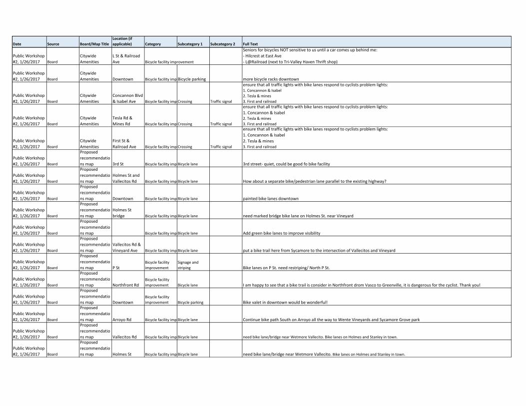
Public Workshop
#2, 1/26/2017 Board
Citywide
Amenities
L St & Railroad
Ave Bicycle facility improvement
Seniors for bicycles NOT sensitive to us until a car comes up behind me:
‐ Hilcrest at East Ave
‐ L@Railroad (next to Tri‐Valley Haven Thrift shop)
Public Workshop
#2, 1/26/2017 Board
Citywide
Amenities Downtown Bicycle facility imp Bicycle parking more bicycle racks downtown
Public Workshop
#2, 1/26/2017 Board
Citywide
Amenities
Concannon Blvd
& Isabel Ave Bicycle facility imp Crossing Traffic signal
ensure that all traffic lights with bike lanes respond to cyclists problem lights:1. Concannon & Isabel
2. Tesla & mines
3. First and railroad
Public Workshop
#2, 1/26/2017 Board
Citywide
Amenities
Tesla Rd &
Mines Rd Bicycle facility imp Crossing Traffic signal
ensure that all traffic lights with bike lanes respond to cyclists problem lights:
1. Concannon & Isabel2. Tesla & mines
3. First and railroad
Public Workshop
#2, 1/26/2017 Board
Citywide
Amenities
First St &
Railroad Ave Bicycle facility imp Crossing Traffic signal
ensure that all traffic lights with bike lanes respond to cyclists problem lights:
1. Concannon & Isabel
2. Tesla & mines3. First and railroad
Public Workshop
#2, 1/26/2017 Board
Proposed
recommendatio
ns map 3rd St Bicycle facility imp Bicycle lane 3rd street‐ quiet, could be good fo bike facility
Public Workshop
#2, 1/26/2017 Board
Proposed
recommendatio
ns map
Holmes St and
Vallecitos Rd Bicycle facility imp Bicycle lane How about a separate bike/pedestrian lane parallel to the existing highway?
Public Workshop
#2, 1/26/2017 Board
Proposed
recommendatio
ns map Downtown Bicycle facility imp Bicycle lane painted bike lanes downtown
Public Workshop
#2, 1/26/2017 Board
Proposed
recommendatio
ns map
Holmes St
bridge Bicycle facility imp Bicycle lane need marked bridge bike lane on Holmes St. near Vineyard
Public Workshop
#2, 1/26/2017 Board
Proposed
recommendatio
ns map Bicycle facility imp Bicycle lane Add green bike lanes to improve visibility
Public Workshop
#2, 1/26/2017 Board
Proposed
recommendatio
ns map
Vallecitos Rd &
Vineyard Ave Bicycle facility imp Bicycle lane put a bike trail here from Sycamore to the intersection of Vallecitos and Vineyard
Public Workshop
#2, 1/26/2017 Board
Proposed
recommendatio
ns map P StBicycle facility
improvement
Signage and
striping Bike lanes on P St. need restriping/ North P St.
Public Workshop
#2, 1/26/2017 Board
Proposed
recommendatio
ns map Northfront RdBicycle facility
improvement Bicycle lane I am happy to see that a bike trail is consider in Northfront drom Vasco to Greenville, it is dangerous for the cyclist. Thank you!
Public Workshop
#2, 1/26/2017 Board
Proposed
recommendatio
ns map DowntownBicycle facility
improvement Bicycle parking Bike valet in downtown would be wonderful!
Public Workshop
#2, 1/26/2017 Board
Proposed
recommendatio
ns map Arroyo Rd Bicycle facility imp Bicycle lane Continue bike path South on Arroyo all the way to Wente Vineyards and Sycamore Grove park
Public Workshop
#2, 1/26/2017 Board
Proposed
recommendatio
ns map Vallecitos Rd Bicycle facility imp Bicycle lane need bike lane/bridge near Wetmore Vallecito. Bike lanes on Holmes and Stanley in town.
Public Workshop
#2, 1/26/2017 Board
Proposed
recommendatio
ns map Holmes St Bicycle facility imp Bicycle lane need bike lane/bridge near Wetmore Vallecito. Bike lanes on Holmes and Stanley in town.
Date Source Board/Map TitleLocation (if applicable) Category Subcategory 1 Subcategory 2 Full Text
Public Workshop
#2, 1/26/2017 Board
Proposed
recommendatio
ns map Stanley Blvd Bicycle facility imp Bicycle lane need bike lane/bridge near Wetmore Vallecito. Bike lanes on Holmes and Stanley in town.
Public Workshop
#2, 1/26/2017 Board
Proposed
recommendatio
ns map Bicycle facility imp Bicycle lane Strongly support separated bike lanes/cycletracks
Public Workshop
#2, 1/26/2017 Board
Proposed
recommendatio
ns map
East Ave &
Vasco RdBicycle facility
improvement Bike Signal need bike signal at East and Vasco when heading west from lab
Public Workshop
#2, 1/26/2017 Board
Proposed
recommendatio
ns map S Livermore Ave Bicycle facility imp Bicycle lane Continue bike path on S. Livermore all the way into downtown. Tis would encourage more people to bike into downtown
Public Workshop
#2, 1/26/2017 Board
Proposed
recommendatio
ns mapBicycle facility
improvement
Signage and
striping Use "bikes may use full land" signs instead of sharrows
Public Workshop
#2, 1/26/2017 Board
Proposed
recommendatio
ns map East Ave Bicycle facility imp Bicycle lane East Ave‐ keep parking all the way‐ remove L/R turn lane to make room for bike path
Public Workshop
#2, 1/26/2017 Board
Proposed
recommendatio
ns map Downtown Bicycle facility imp Bicycle lane New development of downtown plan. Put in bike lanes to downtown and bike to parking.
Public Workshop
#2, 1/26/2017 Board
Proposed
recommendatio
ns map Carnegie Park Bicycle facility imp Bicycle parking
Should build further picnicking tables and benches by the new entertainmen gazebo built by Carnegie Park where the farmers market is held
in summertime. Then people have place to eat food they buy while musicians, etc. perform for them. Consider shade structures around these
and maybe misting for hot weather comfort more water fountains needed too. Benches and bike parking additions too.
Public Workshop
#2, 1/26/2017 Board
Proposed
recommendatio
ns map
Bridge on
Holmes
between
Wetmore and
VineyardBicycle facility
improvement Signage Bikes may use full lanes sign.
Public Workshop
#2, 1/26/2017 Board
Proposed
recommendatio
ns map Holmes St Bicycle facility imp Bicycle lane Bike lanes on Holmes from Concannon north
Public Workshop
#2, 1/26/2017 Board
Proposed
recommendatio
ns map Holmes St Bicycle facility imp Bicycle lane +1 bike lane/travel on Holmes near Vancouver‐ currently one lane. Concept 1 or 3
Public Workshop
#2, 1/26/2017 Board
Proposed
recommendatio
ns map Murrieta Rd Bicycle facility imp Bicycle lane between Portola and Jack London has no bike lane. Kids ride here to school. Lots of bikes on weekends. Riders on road not a safe shoulder.
Public Workshop
#2, 1/26/2017 Board
Proposed
recommendatio
ns map
North Canyons
Pkwy Bicycle facility imp Bicycle lane Please! Make a bike path here! (Fallon to Doolan Rd) Priority to LPC
Public Workshop
#2, 1/26/2017 Board
Proposed
recommendatio
ns map Downtown Bicycle facility imp Bicycle parking Need bike parking stands downtown
Public Workshop
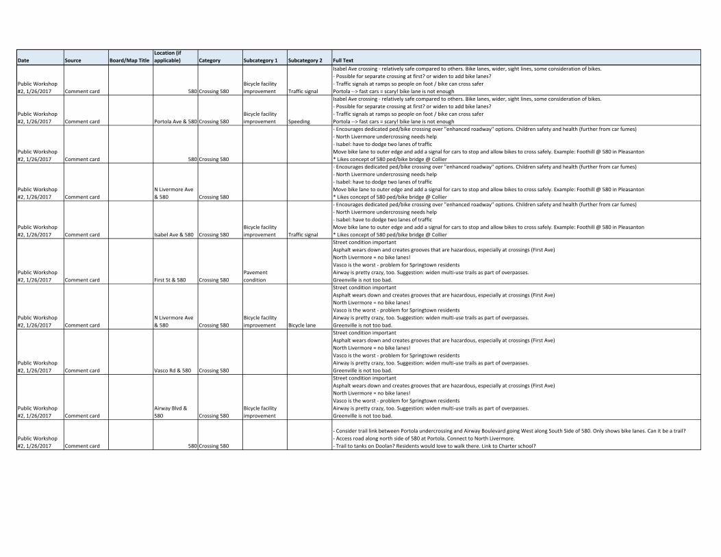
#2, 1/26/2017 Comment card Isabel Ave & 580 Crossing 580
Bicycle facility
improvement
Isabel Ave crossing ‐ relatively safe compared to others. Bike lanes, wider, sight lines, some consideration of bikes.
‐ Possible for separate crossing at first? or widen to add bike lanes?
‐ Traffic signals at ramps so people on foot / bike can cross safer
Portola ‐‐> fast cars = scary! bike lane is not enough
Public Workshop
#2, 1/26/2017 Comment card First St & 580 Crossing 580
Isabel Ave crossing ‐ relatively safe compared to others. Bike lanes, wider, sight lines, some consideration of bikes.
‐ Possible for separate crossing at first? or widen to add bike lanes?
‐ Traffic signals at ramps so people on foot / bike can cross safer
Portola ‐‐> fast cars = scary! bike lane is not enough
Date Source Board/Map TitleLocation (if applicable) Category Subcategory 1 Subcategory 2 Full Text
Public Workshop
#2, 1/26/2017 Comment card 580 Crossing 580
Bicycle facility
improvement Traffic signal
Isabel Ave crossing ‐ relatively safe compared to others. Bike lanes, wider, sight lines, some consideration of bikes.
‐ Possible for separate crossing at first? or widen to add bike lanes?
‐ Traffic signals at ramps so people on foot / bike can cross safer
Portola ‐‐> fast cars = scary! bike lane is not enough
Public Workshop
#2, 1/26/2017 Comment card Portola Ave & 580 Crossing 580
Bicycle facility
improvement Speeding
Isabel Ave crossing ‐ relatively safe compared to others. Bike lanes, wider, sight lines, some consideration of bikes.
‐ Possible for separate crossing at first? or widen to add bike lanes?
‐ Traffic signals at ramps so people on foot / bike can cross safer
Portola ‐‐> fast cars = scary! bike lane is not enough
Public Workshop
#2, 1/26/2017 Comment card 580 Crossing 580
‐ Encourages dedicated ped/bike crossing over "enhanced roadway" options. Children safety and health (further from car fumes)
‐ North Livermore undercrossing needs help
‐ Isabel: have to dodge two lanes of traffic
Move bike lane to outer edge and add a signal for cars to stop and allow bikes to cross safely. Example: Foothill @ 580 in Pleasanton
* Likes concept of 580 ped/bike bridge @ Collier
Public Workshop
#2, 1/26/2017 Comment card
N Livermore Ave
& 580 Crossing 580
‐ Encourages dedicated ped/bike crossing over "enhanced roadway" options. Children safety and health (further from car fumes)
‐ North Livermore undercrossing needs help
‐ Isabel: have to dodge two lanes of traffic
Move bike lane to outer edge and add a signal for cars to stop and allow bikes to cross safely. Example: Foothill @ 580 in Pleasanton
* Likes concept of 580 ped/bike bridge @ Collier
Public Workshop
#2, 1/26/2017 Comment card Isabel Ave & 580 Crossing 580
Bicycle facility
improvement Traffic signal
‐ Encourages dedicated ped/bike crossing over "enhanced roadway" options. Children safety and health (further from car fumes)
‐ North Livermore undercrossing needs help
‐ Isabel: have to dodge two lanes of traffic
Move bike lane to outer edge and add a signal for cars to stop and allow bikes to cross safely. Example: Foothill @ 580 in Pleasanton
* Likes concept of 580 ped/bike bridge @ Collier
Public Workshop
#2, 1/26/2017 Comment card First St & 580 Crossing 580
Pavement
condition
Street condition important
Asphalt wears down and creates grooves that are hazardous, especially at crossings (First Ave)
North Livermore = no bike lanes!
Vasco is the worst ‐ problem for Springtown residents
Airway is pretty crazy, too. Suggestion: widen multi‐use trails as part of overpasses.
Greenville is not too bad.
Public Workshop
#2, 1/26/2017 Comment card
N Livermore Ave
& 580 Crossing 580
Bicycle facility
improvement Bicycle lane
Street condition important
Asphalt wears down and creates grooves that are hazardous, especially at crossings (First Ave)
North Livermore = no bike lanes!
Vasco is the worst ‐ problem for Springtown residents
Airway is pretty crazy, too. Suggestion: widen multi‐use trails as part of overpasses.
Greenville is not too bad.
Public Workshop
#2, 1/26/2017 Comment card Vasco Rd & 580 Crossing 580
Street condition important
Asphalt wears down and creates grooves that are hazardous, especially at crossings (First Ave)
North Livermore = no bike lanes!
Vasco is the worst ‐ problem for Springtown residents
Airway is pretty crazy, too. Suggestion: widen multi‐use trails as part of overpasses.
Greenville is not too bad.
Public Workshop
#2, 1/26/2017 Comment card
Airway Blvd &
580 Crossing 580
Bicycle facility
improvement
Street condition important
Asphalt wears down and creates grooves that are hazardous, especially at crossings (First Ave)
North Livermore = no bike lanes!
Vasco is the worst ‐ problem for Springtown residents
Airway is pretty crazy, too. Suggestion: widen multi‐use trails as part of overpasses.
Greenville is not too bad.
Public Workshop
#2, 1/26/2017 Comment card 580 Crossing 580
‐ Consider trail link between Portola undercrossing and Airway Boulevard going West along South Side of 580. Only shows bike lanes. Can it be a trail?
‐ Access road along north side of 580 at Portola. Connect to North Livermore.
‐ Trail to tanks on Doolan? Residents would love to walk there. Link to Charter school?
Date Source Board/Map TitleLocation (if applicable) Category Subcategory 1 Subcategory 2 Full Text
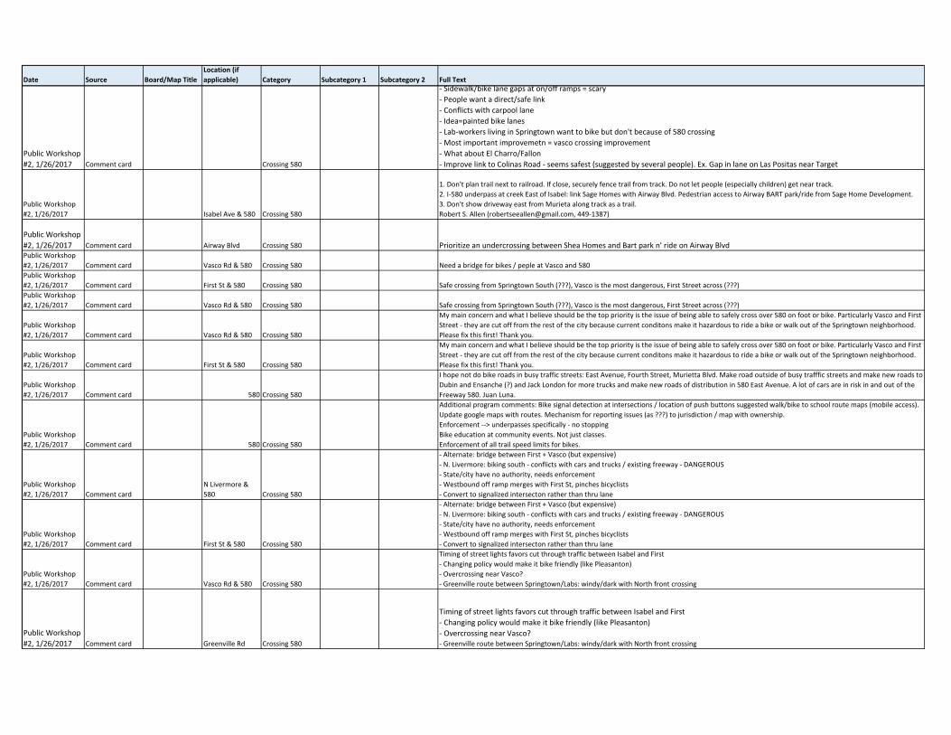
Public Workshop
#2, 1/26/2017 Comment card Crossing 580
‐ Sidewalk/bike lane gaps at on/off ramps = scary
‐ People want a direct/safe link
‐ Conflicts with carpool lane
‐ Idea=painted bike lanes
‐ Lab‐workers living in Springtown want to bike but don't because of 580 crossing
‐ Most important improvemetn = vasco crossing improvement
‐ What about El Charro/Fallon
‐ Improve link to Colinas Road ‐ seems safest (suggested by several people). Ex. Gap in lane on Las Positas near Target
Public Workshop
#2, 1/26/2017 Isabel Ave & 580 Crossing 580
1. Don't plan trail next to railroad. If close, securely fence trail from track. Do not let people (especially children) get near track.
2. I‐580 underpass at creek East of Isabel: link Sage Homes with Airway Blvd. Pedestrian access to Airway BART park/ride from Sage Home Development.
3. Don't show driveway east from Murieta along track as a trail.
Robert S. Allen ([email protected], 449‐1387)
Public Workshop
#2, 1/26/2017 Comment card Airway Blvd Crossing 580 Prioritize an undercrossing between Shea Homes and Bart park n' ride on Airway BlvdPublic Workshop
#2, 1/26/2017 Comment card Vasco Rd & 580 Crossing 580 Need a bridge for bikes / peple at Vasco and 580
Public Workshop
#2, 1/26/2017 Comment card First St & 580 Crossing 580 Safe crossing from Springtown South (???), Vasco is the most dangerous, First Street across (???)
Public Workshop
#2, 1/26/2017 Comment card Vasco Rd & 580 Crossing 580 Safe crossing from Springtown South (???), Vasco is the most dangerous, First Street across (???)
Public Workshop
#2, 1/26/2017 Comment card Vasco Rd & 580 Crossing 580
My main concern and what I believe should be the top priority is the issue of being able to safely cross over 580 on foot or bike. Particularly Vasco and First
Street ‐ they are cut off from the rest of the city because current conditons make it hazardous to ride a bike or walk out of the Springtown neighborhood.
Please fix this first! Thank you.
Public Workshop
#2, 1/26/2017 Comment card First St & 580 Crossing 580
My main concern and what I believe should be the top priority is the issue of being able to safely cross over 580 on foot or bike. Particularly Vasco and First
Street ‐ they are cut off from the rest of the city because current conditons make it hazardous to ride a bike or walk out of the Springtown neighborhood.
Please fix this first! Thank you.
Public Workshop
#2, 1/26/2017 Comment card 580 Crossing 580
I hope not do bike roads in busy traffic streets: East Avenue, Fourth Street, Murietta Blvd. Make road outside of busy trafffic streets and make new roads to
Dubin and Ensanche (?) and Jack London for more trucks and make new roads of distribution in 580 East Avenue. A lot of cars are in risk in and out of the
Freeway 580. Juan Luna.
Public Workshop
#2, 1/26/2017 Comment card 580 Crossing 580
Additional program comments: Bike signal detection at intersections / location of push buttons suggested walk/bike to school route maps (mobile access).
Update google maps with routes. Mechanism for reporting issues (as ???) to jurisdiction / map with ownership.
Enforcement ‐‐> underpasses specifically ‐ no stopping
Bike education at community events. Not just classes.
Enforcement of all trail speed limits for bikes.
Public Workshop
#2, 1/26/2017 Comment card
N Livermore &
580 Crossing 580
‐ Alternate: bridge between First + Vasco (but expensive)
‐ N. Livermore: biking south ‐ conflicts with cars and trucks / existing freeway ‐ DANGEROUS
‐ State/city have no authority, needs enforcement
‐ Westbound off ramp merges with First St, pinches bicyclists
‐ Convert to signalized intersecton rather than thru lane
Public Workshop
#2, 1/26/2017 Comment card First St & 580 Crossing 580
‐ Alternate: bridge between First + Vasco (but expensive)
‐ N. Livermore: biking south ‐ conflicts with cars and trucks / existing freeway ‐ DANGEROUS
‐ State/city have no authority, needs enforcement
‐ Westbound off ramp merges with First St, pinches bicyclists
‐ Convert to signalized intersecton rather than thru lane
Public Workshop
#2, 1/26/2017 Comment card Vasco Rd & 580 Crossing 580
Timing of street lights favors cut through traffic between Isabel and First
‐ Changing policy would make it bike friendly (like Pleasanton)
‐ Overcrossing near Vasco?
‐ Greenville route between Springtown/Labs: windy/dark with North front crossing
Public Workshop
#2, 1/26/2017 Comment card Greenville Rd Crossing 580
Timing of street lights favors cut through traffic between Isabel and First
‐ Changing policy would make it bike friendly (like Pleasanton)
‐ Overcrossing near Vasco?‐ Greenville route between Springtown/Labs: windy/dark with North front crossing
Date Source Board/Map TitleLocation (if applicable) Category Subcategory 1 Subcategory 2 Full Text
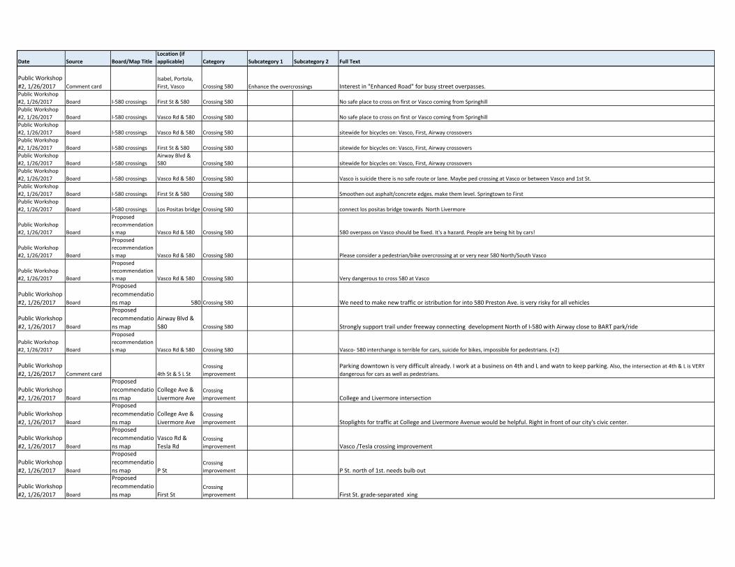
Public Workshop
#2, 1/26/2017 Comment card
Isabel, Portola,
First, Vasco Crossing 580 Enhance the overcrossings Interest in "Enhanced Road" for busy street overpasses.Public Workshop
#2, 1/26/2017 Board I‐580 crossings First St & 580 Crossing 580 No safe place to cross on first or Vasco coming from Springhill
Public Workshop
#2, 1/26/2017 Board I‐580 crossings Vasco Rd & 580 Crossing 580 No safe place to cross on first or Vasco coming from Springhill
Public Workshop
#2, 1/26/2017 Board I‐580 crossings Vasco Rd & 580 Crossing 580 sitewide for bicycles on: Vasco, First, Airway crossovers
Public Workshop
#2, 1/26/2017 Board I‐580 crossings First St & 580 Crossing 580 sitewide for bicycles on: Vasco, First, Airway crossovers
Public Workshop
#2, 1/26/2017 Board I‐580 crossings
Airway Blvd &
580 Crossing 580 sitewide for bicycles on: Vasco, First, Airway crossovers
Public Workshop
#2, 1/26/2017 Board I‐580 crossings Vasco Rd & 580 Crossing 580 Vasco is suicide there is no safe route or lane. Maybe ped crossing at Vasco or between Vasco and 1st St.
Public Workshop
#2, 1/26/2017 Board I‐580 crossings First St & 580 Crossing 580 Smoothen out asphalt/concrete edges. make them level. Springtown to First
Public Workshop
#2, 1/26/2017 Board I‐580 crossings Los Positas bridge Crossing 580 connect los positas bridge towards North Livermore
Public Workshop
#2, 1/26/2017 Board
Proposed
recommendation
s map Vasco Rd & 580 Crossing 580 580 overpass on Vasco should be fixed. It's a hazard. People are being hit by cars!
Public Workshop
#2, 1/26/2017 Board
Proposed
recommendation
s map Vasco Rd & 580 Crossing 580 Please consider a pedestrian/bike overcrossing at or very near 580 North/South Vasco
Public Workshop
#2, 1/26/2017 Board
Proposed
recommendation
s map Vasco Rd & 580 Crossing 580 Very dangerous to cross 580 at Vasco
Public Workshop
#2, 1/26/2017 Board
Proposed
recommendatio
ns map 580 Crossing 580 We need to make new traffic or istribution for into 580 Preston Ave. is very risky for all vehicles
Public Workshop
#2, 1/26/2017 Board
Proposed
recommendatio
ns map
Airway Blvd &
580 Crossing 580 Strongly support trail under freeway connecting development North of I‐580 with Airway close to BART park/ride
Public Workshop
#2, 1/26/2017 Board
Proposed
recommendation
s map Vasco Rd & 580 Crossing 580 Vasco‐ 580 interchange is terrible for cars, suicide for bikes, impossible for pedestrians. (+2)
Public Workshop
#2, 1/26/2017 Comment card 4th St & S L St
Crossing
improvement
Parking downtown is very difficult already. I work at a business on 4th and L and watn to keep parking. Also, the intersection at 4th & L is VERY dangerous for cars as well as pedestrians.
Public Workshop
#2, 1/26/2017 Board
Proposed
recommendatio
ns map
College Ave &
Livermore AveCrossing
improvement College and Livermore intersection
Public Workshop
#2, 1/26/2017 Board
Proposed
recommendatio
ns map
College Ave &
Livermore AveCrossing
improvement Stoplights for traffic at College and Livermore Avenue would be helpful. Right in front of our city's civic center.
Public Workshop
#2, 1/26/2017 Board
Proposed
recommendatio
ns map
Vasco Rd &
Tesla RdCrossing
improvement Vasco /Tesla crossing improvement
Public Workshop
#2, 1/26/2017 Board
Proposed
recommendatio
ns map P StCrossing
improvement P St. north of 1st. needs bulb out
Public Workshop
#2, 1/26/2017 Board
Proposed
recommendatio
ns map First StCrossing
improvement First St. grade‐separated xing
Date Source Board/Map TitleLocation (if applicable) Category Subcategory 1 Subcategory 2 Full Text
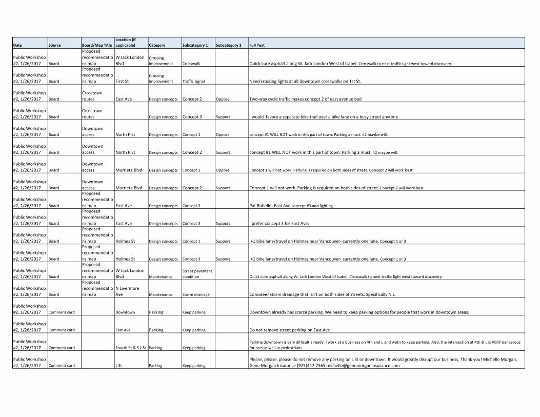
Public Workshop
#2, 1/26/2017 Board
Proposed
recommendatio
ns map
W Jack London
BlvdCrossing
improvement Crosswalk Quick cure asphalt along W. Jack London West of Isabel. Crosswalk to next traffic light west toward discovery.
Public Workshop
#2, 1/26/2017 Board
Proposed
recommendatio
ns map First StCrossing
improvement Traffic signal Need crossing lights at all downtown crosswalks on 1st St.
Public Workshop
#2, 1/26/2017 Board
Crosstown
routes East Ave Design concepts Concept 2 Oppose Two‐way cycle traffic makes concept 2 of east avenue bad
Public Workshop
#2, 1/26/2017 Board
Crosstown
routes Design concepts Concept 3 Support I would favore a separate bike trail over a bike lane on a busy street anytime
Public Workshop
#2, 1/26/2017 Board
Downtown
access North P St Design concepts Concept 1 Oppose concept #1 WILL NOT work in this part of town. Parking a must. #2 maybe will.
Public Workshop
#2, 1/26/2017 Board
Downtown
access North P St Design concepts Concept 2 Support concept #1 WILL NOT work in this part of town. Parking a must. #2 maybe will.
Public Workshop
#2, 1/26/2017 Board
Downtown
access Murrieta Blvd. Design concepts Concept 1 Oppose Concept 1 will not work. Parking is required on both sides of street. Concept 2 will work best.
Public Workshop
#2, 1/26/2017 Board
Downtown
access Murrieta Blvd. Design concepts Concept 2 Support Concept 1 will not work. Parking is required on both sides of street. Concept 2 will work best.
Public Workshop
#2, 1/26/2017 Board
Proposed
recommendatio
ns map East Ave Design concepts Concept 3 Pat Robello‐ East Ave concept #3 and lighting
Public Workshop
#2, 1/26/2017 Board
Proposed
recommendatio
ns map East Ave Design concepts Concept 3 Support I prefer concept 3 for East Ave.
Public Workshop
#2, 1/26/2017 Board
Proposed
recommendatio
ns map Holmes St Design concepts Concept 1 Support +1 bike lane/travel on Holmes near Vancouver‐ currently one lane. Concept 1 or 3
Public Workshop
#2, 1/26/2017 Board
Proposed
recommendatio
ns map Holmes St Design concepts Concept 3 Support +1 bike lane/travel on Holmes near Vancouver‐ currently one lane. Concept 1 or 3
Public Workshop
#2, 1/26/2017 Board
Proposed
recommendatio
ns map
W Jack London
Blvd Maintenance
Street pavement
condition Quick cure asphalt along W. Jack London West of Isabel. Crosswalk to next traffic light west toward discovery.
Public Workshop
#2, 1/26/2017 Board
Proposed
recommendatio
ns map
N Livermore
Ave Maintenance Storm drainage Consideer storm drainage that isn't on both sides of streets. Specifically N.L.
Public Workshop
#2, 1/26/2017 Comment card Downtown Parking Keep parking Downtown already has scarce parking. We need to keep parking options for people that work in downtown areas.
Public Workshop
#2, 1/26/2017 Comment card East Ave Parking Keep parking Do not remove street parking on East Ave
Public Workshop
#2, 1/26/2017 Comment card Fourth St & S L St Parking Keep parking
Parking downtown is very difficult already. I work at a business on 4th and L and watn to keep parking. Also, the intersection at 4th & L is VERY dangerous
for cars as well as pedestrians.
Public Workshop
#2, 1/26/2017 Comment card L St Parking Keep parking
Please, please, please do not remove any parking on L St or downtown. It would greatly disrupt our business. Thank you! Michelle Morgan,
Gene Morgan Insurance (925)447‐2565 [email protected]
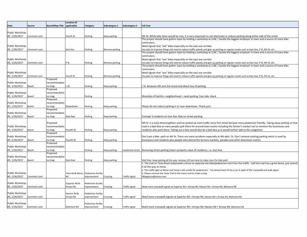
Date Source Board/Map TitleLocation (if applicable) Category Subcategory 1 Subcategory 2 Full Text
Public Workshop
#2, 1/26/2017 Comment card Fourth St Parking Keep parking 4th St: While bike lanes would be nice, it is very important to not eleminate or reduce parking along either side of the street
Public Workshop
#2, 1/26/2017 Comment card East Ave Parking Remove parking
The project should have gotten input by holding a workshop at LLNC / Sandia the biggest employer in town and a source of many bike
commuters.
Need signals that "see" bikes especially on the east ave corridorAny plan to improve things will need to reduce traffic speeds and give up parking on regular routes such as East Ave, P St, 4th St, etc.
Public Workshop
#2, 1/26/2017 Comment card P St Parking Remove parking
The project should have gotten input by holding a workshop at LLNC / Sandia the biggest employer in town and a source of many bike
commuters.
Need signals that "see" bikes especially on the east ave corridorAny plan to improve things will need to reduce traffic speeds and give up parking on regular routes such as East Ave, P St, 4th St, etc.
Public Workshop
#2, 1/26/2017 Comment card Fourth St Parking Remove parking
The project should have gotten input by holding a workshop at LLNC / Sandia the biggest employer in town and a source of many bike
commuters.
Need signals that "see" bikes especially on the east ave corridorAny plan to improve things will need to reduce traffic speeds and give up parking on regular routes such as East Ave, P St, 4th St, etc.
Public Workshop
#2, 1/26/2017 Board
Proposed
recommendatio
ns map L St. Parking Keep parking L St. between 4th and 3rd concerned about loss of parking
Public Workshop
#2, 1/26/2017 Board
Proposed
recommendatio
ns map Parking Westside of EastVin= neighborhood = need parking. East side‐ block
Public Workshop
#2, 1/26/2017 Board
Proposed
recommendatio
ns map Downtown Parking Keep parking Please do not reduce parking in or near downtown. Thank you!
Public Workshop
#2, 1/26/2017 Board
Proposed
recommendatio
ns map East Ave Parking Keep parking Concept 3 residents on East Ave. Rely on street parking.
Public Workshop
#2, 1/26/2017 Board
Proposed
recommendatio
ns map Fourth St Parking Keep parking
4th St. is a main thouroughfare and has picked up more traffic since first street became more pedestrian friendly. Taking away parking on that
road is a bad idea as many people park there for around town events including the farmer's market not to mention the businesses and
residents who park there. Taking out a lane would also be a bad idea as it would further add to the congestion.
Public Workshop
#2, 1/26/2017 Board
Proposed
recommendatio
ns map Fourth St Parking Keep parking
Don't put a bike path on 4th St. There are many accidents especially at 4th abd L St. Don't remove existing parking which is used by
businesses and residents plus people who attend the farmers markets, parades and other downtown events.
Public Workshop
#2, 1/26/2017 Board
Proposed
recommendatio
ns map Parking Keep parking residential street Removing street parking lowers property value of residence. i.e. East Ave.
Public Workshop
#2, 1/26/2017 Board
Proposed
recommendatio
ns map East Ave Parking Keep parking East Ave‐ keep parking all the way‐ remove L/R turn lane to make room for bike path
Public Workshop
#2, 1/26/2017 Comment card
Tesla Rd & Mines
Rd
Pedestrian facility
improvement Crossing Traffic signal
1. The trail on Tesla Road reallyneeds a fence to separate the bike/pedestrian trail from the traffic ‐ half the trail has a great fence, just extend
it all the way to mines2. The traffic light at Mines and Tesla is still unsafe for pedestrians ‐ I've almost been hit by a car in spite of the crosswalk and walk signal
3. Please connect the Tesla Trail to the Vasco trail to make a loop
Public Workshop
#2, 1/26/2017 Comment card
SUperior Rd &
Arroyo Rd
Pedestrian facility
improvement Crossing Traffic signal Need more crosswalk signals at Superior Rd + Arroyo Rd, Hanson Rd + Arroyo Rd, Wetmore Rd
Public Workshop
#2, 1/26/2017 Comment card
Hanson Rd &
Arroyo Rd
Pedestrian facility
improvement Crossing Traffic signal Need more crosswalk signals at Superior Rd + Arroyo Rd, Hanson Rd + Arroyo Rd, Wetmore Rd
Public Workshop
#2, 1/26/2017 Comment card Wetmore Rd
Pedestrian facility
improvement Crossing Traffic signal Need more crosswalk signals at Superior Rd + Arroyo Rd, Hanson Rd + Arroyo Rd, Wetmore Rd
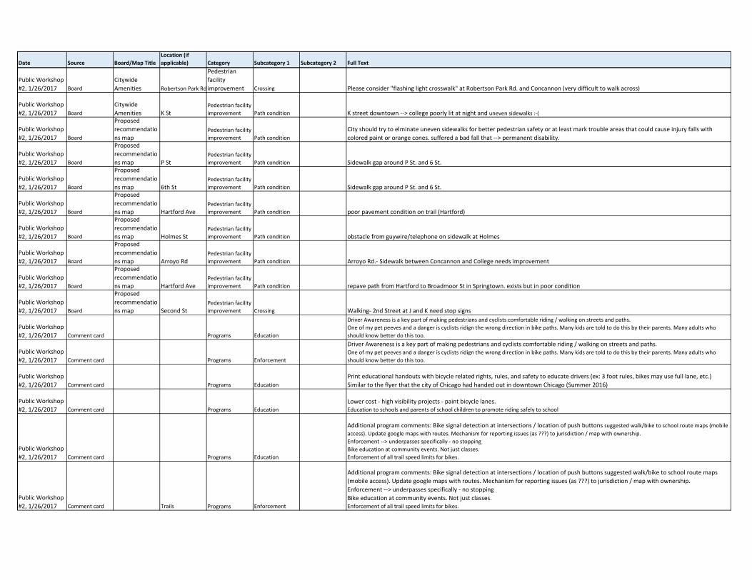
Date Source Board/Map TitleLocation (if applicable) Category Subcategory 1 Subcategory 2 Full Text
Public Workshop
#2, 1/26/2017 Board
Citywide
Amenities Robertson Park Rd
Pedestrian
facility
improvement Crossing Please consider "flashing light crosswalk" at Robertson Park Rd. and Concannon (very difficult to walk across)
Public Workshop
#2, 1/26/2017 Board
Citywide
Amenities K StPedestrian facility
improvement Path condition K street downtown ‐‐> college poorly lit at night and uneven sidewalks :‐(
Public Workshop
#2, 1/26/2017 Board
Proposed
recommendatio
ns mapPedestrian facility
improvement Path condition
City should try to elminate uneven sidewalks for better pedestrian safety or at least mark trouble areas that could cause injury falls with
colored paint or orange cones. suffered a bad fall that ‐‐> permanent disability.
Public Workshop
#2, 1/26/2017 Board
Proposed
recommendatio
ns map P StPedestrian facility
improvement Path condition Sidewalk gap around P St. and 6 St.
Public Workshop
#2, 1/26/2017 Board
Proposed
recommendatio
ns map 6th StPedestrian facility
improvement Path condition Sidewalk gap around P St. and 6 St.
Public Workshop
#2, 1/26/2017 Board
Proposed
recommendatio
ns map Hartford AvePedestrian facility
improvement Path condition poor pavement condition on trail (Hartford)
Public Workshop
#2, 1/26/2017 Board
Proposed
recommendatio
ns map Holmes StPedestrian facility
improvement Path condition obstacle from guywire/telephone on sidewalk at Holmes
Public Workshop
#2, 1/26/2017 Board
Proposed
recommendatio
ns map Arroyo RdPedestrian facility
improvement Path condition Arroyo Rd.‐ Sidewalk between Concannon and College needs improvement
Public Workshop
#2, 1/26/2017 Board
Proposed
recommendatio
ns map Hartford AvePedestrian facility
improvement Path condition repave path from Hartford to Broadmoor St in Springtown. exists but in poor condition
Public Workshop
#2, 1/26/2017 Board
Proposed
recommendatio
ns map Second StPedestrian facility
improvement Crossing Walking‐ 2nd Street at J and K need stop signs
Public Workshop
#2, 1/26/2017 Comment card Programs Education
Driver Awareness is a key part of making pedestrians and cyclists comfortable riding / walking on streets and paths.
One of my pet peeves and a danger is cyclists ridign the wrong direction in bike paths. Many kids are told to do this by their parents. Many adults who
should know better do this too.
Public Workshop
#2, 1/26/2017 Comment card Programs Enforcement
Driver Awareness is a key part of making pedestrians and cyclists comfortable riding / walking on streets and paths.One of my pet peeves and a danger is cyclists ridign the wrong direction in bike paths. Many kids are told to do this by their parents. Many adults who
should know better do this too.
Public Workshop
#2, 1/26/2017 Comment card Programs Education
Print educational handouts with bicycle related rights, rules, and safety to educate drivers (ex: 3 foot rules, bikes may use full lane, etc.)
Similar to the flyer that the city of Chicago had handed out in downtown Chicago (Summer 2016)
Public Workshop
#2, 1/26/2017 Comment card Programs Education
Lower cost ‐ high visibility projects ‐ paint bicycle lanes. Education to schools and parents of school children to promote riding safely to school
Public Workshop
#2, 1/26/2017 Comment card Programs Education
Additional program comments: Bike signal detection at intersections / location of push buttons suggested walk/bike to school route maps (mobile
access). Update google maps with routes. Mechanism for reporting issues (as ???) to jurisdiction / map with ownership.
Enforcement ‐‐> underpasses specifically ‐ no stopping
Bike education at community events. Not just classes.
Enforcement of all trail speed limits for bikes.
Public Workshop
#2, 1/26/2017 Comment card Trails Programs Enforcement
Additional program comments: Bike signal detection at intersections / location of push buttons suggested walk/bike to school route maps
(mobile access). Update google maps with routes. Mechanism for reporting issues (as ???) to jurisdiction / map with ownership.
Enforcement ‐‐> underpasses specifically ‐ no stopping
Bike education at community events. Not just classes.Enforcement of all trail speed limits for bikes.
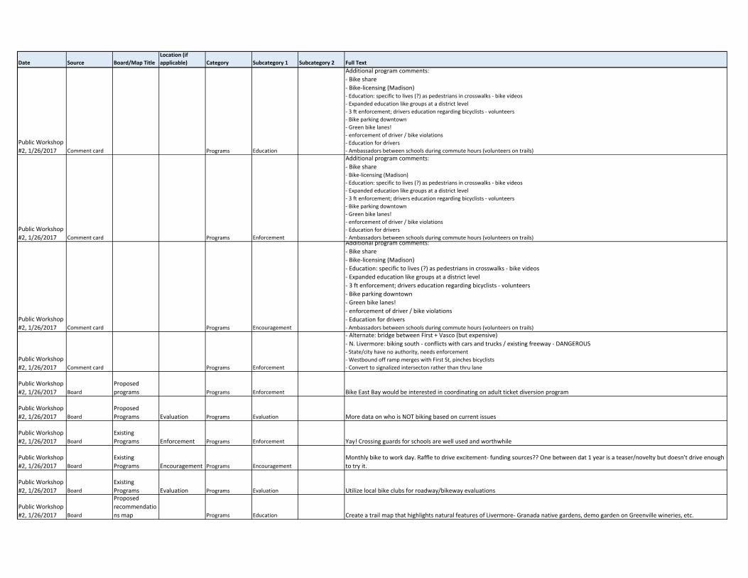
Date Source Board/Map TitleLocation (if applicable) Category Subcategory 1 Subcategory 2 Full Text
Public Workshop
#2, 1/26/2017 Comment card Programs Education
Additional program comments:
‐ Bike share
‐ Bike‐licensing (Madison)‐ Education: specific to lives (?) as pedestrians in crosswalks ‐ bike videos
‐ Expanded education like groups at a district level
‐ 3 ft enforcement; drivers education regarding bicyclists ‐ volunteers
‐ Bike parking downtown
‐ Green bike lanes!
‐ enforcement of driver / bike violations
‐ Education for drivers
‐ Ambassadors between schools during commute hours (volunteers on trails)
Public Workshop
#2, 1/26/2017 Comment card Programs Enforcement
Additional program comments:
‐ Bike share‐ Bike‐licensing (Madison)
‐ Education: specific to lives (?) as pedestrians in crosswalks ‐ bike videos
‐ Expanded education like groups at a district level
‐ 3 ft enforcement; drivers education regarding bicyclists ‐ volunteers
‐ Bike parking downtown
‐ Green bike lanes!
‐ enforcement of driver / bike violations
‐ Education for drivers
‐ Ambassadors between schools during commute hours (volunteers on trails)
Public Workshop
#2, 1/26/2017 Comment card Programs Encouragement
Additional program comments:
‐ Bike share
‐ Bike‐licensing (Madison)
‐ Education: specific to lives (?) as pedestrians in crosswalks ‐ bike videos
‐ Expanded education like groups at a district level
‐ 3 ft enforcement; drivers education regarding bicyclists ‐ volunteers
‐ Bike parking downtown
‐ Green bike lanes!
‐ enforcement of driver / bike violations
‐ Education for drivers‐ Ambassadors between schools during commute hours (volunteers on trails)
Public Workshop
#2, 1/26/2017 Comment card Programs Enforcement
‐ Alternate: bridge between First + Vasco (but expensive)
‐ N. Livermore: biking south ‐ conflicts with cars and trucks / existing freeway ‐ DANGEROUS‐ State/city have no authority, needs enforcement
‐ Westbound off ramp merges with First St, pinches bicyclists
‐ Convert to signalized intersecton rather than thru lane
Public Workshop
#2, 1/26/2017 Board
Proposed
programs Programs Enforcement Bike East Bay would be interested in coordinating on adult ticket diversion program
Public Workshop
#2, 1/26/2017 Board
Proposed
Programs Evaluation Programs Evaluation More data on who is NOT biking based on current issues
Public Workshop
#2, 1/26/2017 Board
Existing
Programs Enforcement Programs Enforcement Yay! Crossing guards for schools are well used and worthwhile
Public Workshop
#2, 1/26/2017 Board
Existing
Programs Encouragement Programs Encouragement
Monthly bike to work day. Raffle to drive excitement‐ funding sources?? One between dat 1 year is a teaser/novelty but doesn't drive enough
to try it.
Public Workshop
#2, 1/26/2017 Board
Existing
Programs Evaluation Programs Evaluation Utilize local bike clubs for roadway/bikeway evaluations
Public Workshop
#2, 1/26/2017 Board
Proposed
recommendatio
ns map Programs Education Create a trail map that highlights natural features of Livermore‐ Granada native gardens, demo garden on Greenville wineries, etc.
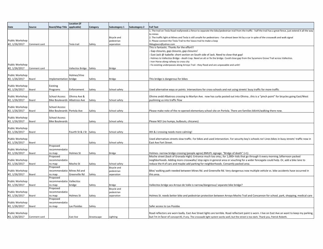
Date Source Board/Map TitleLocation (if applicable) Category Subcategory 1 Subcategory 2 Full Text
Public Workshop
#2, 1/26/2017 Comment card Tesla trail Safety
Bicycle and
pedestrian
seperation
1. The trail on Tesla Road reallyneeds a fence to separate the bike/pedestrian trail from the traffic ‐ half the trail has a great fence, just extend it all the way
to mines
2. The traffic light at Mines and Tesla is still unsafe for pedestrians ‐ I've almost been hit by a car in spite of the crosswalk and walk signal
3. Please connect the Tesla Trail to the Vasco trail to make a loop
Public Workshop
#2, 1/26/2017 Comment card Vallecitos Bridge Safety Bridge
This is fantastic. Thanks for the effort!!
‐ Gap closures, gap closures, gap closures!
‐ East Jack @ Isabelle: short section on South side of Jack. Need to close that gap!‐ Holmes to Vallecitos Bridge ‐ death trap. Need an alt or fix the bridge. Could close gap from the Sycamore Grove Trail across Vallecitos.
‐ Iron Horse along railway to cross city
‐ Fix existing underpasses along Arroyo Trail ‐ they flood and are unpassable and unlit!
Public Workshop
#2, 1/26/2017 Board Implementation
Holmes/Vine
bridge Safety Bridge This bridge is dangerous for bikes
Public Workshop
#2, 1/26/2017 Board
Existing
Programs Enforcement Safety School safety Used alternative ways or points intersections for cross‐schools and not using streets' busy traffic for more traffic
Public Workshop
#2, 1/26/2017 Board
School Access:
Bike Boulevards
Olivina Ave &
Albatross Ave Safety School safety
Olivine andd Albatross crossing to Marilyn Ave. now has curbs posted out into Olivina...this is a "pinch point" for bicycles going East/West
pushining us into traffic flow
Public Workshop
#2, 1/26/2017 Board
School Access:
Bike Boulevards Portola Ave Safety School safety Please make note of the re‐opened elementary school site on Portola. There are families bikinh/walking there now.
Public Workshop
#2, 1/26/2017 Board
School Access:
Bike Boulevards Safety School safety Please NO! (no humps, bulbouts, chicanes)
Public Workshop
#2, 1/26/2017 Board Fourth St & J St Safety School safety 4th & J crossing needs more calming!
Public Workshop
#2, 1/26/2017 Board Safety School safety
Used alternatives streets slow traffic. For bikes and used intersection. For security boy's schools no! Lines bikes in busy streets' traffic now in
East Ave Fort Street.
Public Workshop
#2, 1/26/2017 Board
Proposed
recommendatio
ns map Holmes St Safety Bridge Holmes‐ narrow bridge crossing (people agree) BMUFL signage. "Bridge of death" (+1)
Public Workshop
#2, 1/26/2017 Board
Proposed
recommendatio
ns map Mocho St Safety School safety
Moche street (back of Granada High): Entrance much too sma;; for 1,000+ kids that go through it every morning /afternoon packed
neighborhoods. Adding more crosswalks/ stop signs in general area or vouching for a wider fencegate could help. Or, add a bike lane to
reduce the # of cars and maybe add parking for neighborhoods. Consantly packed area.
Public Workshop
#2, 1/26/2017 Board
Proposed
recommendatio
ns map
Mines Rd and
Greenville Rd Safety
Bicycle and
pedestrian
seperation
Bike/ walking path needed between Mines Rd. and Greenville Rd. Very dangerous now multiple vehicle vs. bike accidents have occurred in
this area.
Public Workshop
#2, 1/26/2017 Board
Proposed
recommendatio
ns map
Vallecitos
bridge Safety Bridge Vallecitos bridge acx Arroyo de Valle is narrow/dangerous/ separate bike bridge?
Public Workshop
#2, 1/26/2017 Board
Proposed
recommendatio
ns map Holmes St Safety
Bicycle and
pedestrian
seperation Holmes St. needs better bike and pedestrian protection between Arroyo Mocho Trail and Concannon for school, park, shopping, medical care
Public Workshop
#2, 1/26/2017 Board
Proposed
recommendatio
ns map Las Posidas Safety Safer access to Las Posidas
Public Workshop
#2, 1/26/2017 Comment card East Ave Streetscape Lighting
Road reflectors are worn badly. East Ave Street lights are terrible. Road reflectant paint is worn. I live on East Ave an want to keep my parking,
but I'm in facor of concept #3, if any. The crosswalk light system works well, but the street is too dark. Thank you, Patrick Robeth.
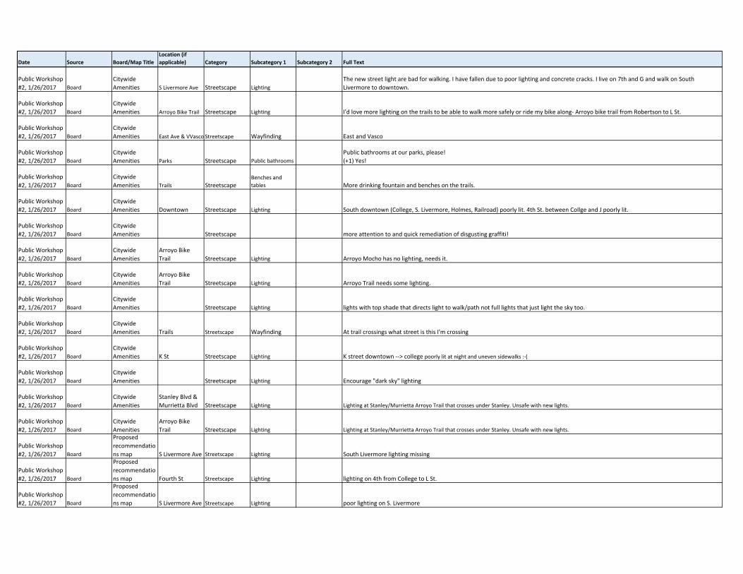
Date Source Board/Map TitleLocation (if applicable) Category Subcategory 1 Subcategory 2 Full Text
Public Workshop
#2, 1/26/2017 Board
Citywide
Amenities S Livermore Ave Streetscape Lighting
The new street light are bad for walking. I have fallen due to poor lighting and concrete cracks. I live on 7th and G and walk on South
Livermore to downtown.
Public Workshop
#2, 1/26/2017 Board
Citywide
Amenities Arroyo Bike Trail Streetscape Lighting I'd love more lighting on the trails to be able to walk more safely or ride my bike along‐ Arroyo bike trail from Robertson to L St.
Public Workshop
#2, 1/26/2017 Board
Citywide
Amenities East Ave & VVasco Streetscape Wayfinding East and Vasco
Public Workshop
#2, 1/26/2017 Board
Citywide
Amenities Parks Streetscape Public bathrooms
Public bathrooms at our parks, please!
(+1) Yes!
Public Workshop
#2, 1/26/2017 Board
Citywide
Amenities Trails StreetscapeBenches and
tables More drinking fountain and benches on the trails.
Public Workshop
#2, 1/26/2017 Board
Citywide
Amenities Downtown Streetscape Lighting South downtown (College, S. Livermore, Holmes, Railroad) poorly lit. 4th St. between Collge and J poorly lit.
Public Workshop
#2, 1/26/2017 Board
Citywide
Amenities Streetscape more attention to and quick remediation of disgusting graffiti!
Public Workshop
#2, 1/26/2017 Board
Citywide
Amenities
Arroyo Bike
Trail Streetscape Lighting Arroyo Mocho has no lighting, needs it.
Public Workshop
#2, 1/26/2017 Board
Citywide
Amenities
Arroyo Bike
Trail Streetscape Lighting Arroyo Trail needs some lighting.
Public Workshop
#2, 1/26/2017 Board
Citywide
Amenities Streetscape Lighting lights with top shade that directs light to walk/path not full lights that just light the sky too.
Public Workshop
#2, 1/26/2017 Board
Citywide
Amenities Trails Streetscape Wayfinding At trail crossings what street is this I'm crossing
Public Workshop
#2, 1/26/2017 Board
Citywide
Amenities K St Streetscape Lighting K street downtown ‐‐> college poorly lit at night and uneven sidewalks :‐(
Public Workshop
#2, 1/26/2017 Board
Citywide
Amenities Streetscape Lighting Encourage "dark sky" lighting
Public Workshop
#2, 1/26/2017 Board
Citywide
Amenities
Stanley Blvd &
Murrietta Blvd Streetscape Lighting Lighting at Stanley/Murrietta Arroyo Trail that crosses under Stanley. Unsafe with new lights.
Public Workshop
#2, 1/26/2017 Board
Citywide
Amenities
Arroyo Bike
Trail Streetscape Lighting Lighting at Stanley/Murrietta Arroyo Trail that crosses under Stanley. Unsafe with new lights.
Public Workshop
#2, 1/26/2017 Board
Proposed
recommendatio
ns map S Livermore Ave Streetscape Lighting South Livermore lighting missing
Public Workshop
#2, 1/26/2017 Board
Proposed
recommendatio
ns map Fourth St Streetscape Lighting lighting on 4th from College to L St.
Public Workshop
#2, 1/26/2017 Board
Proposed
recommendatio
ns map S Livermore Ave Streetscape Lighting poor lighting on S. Livermore
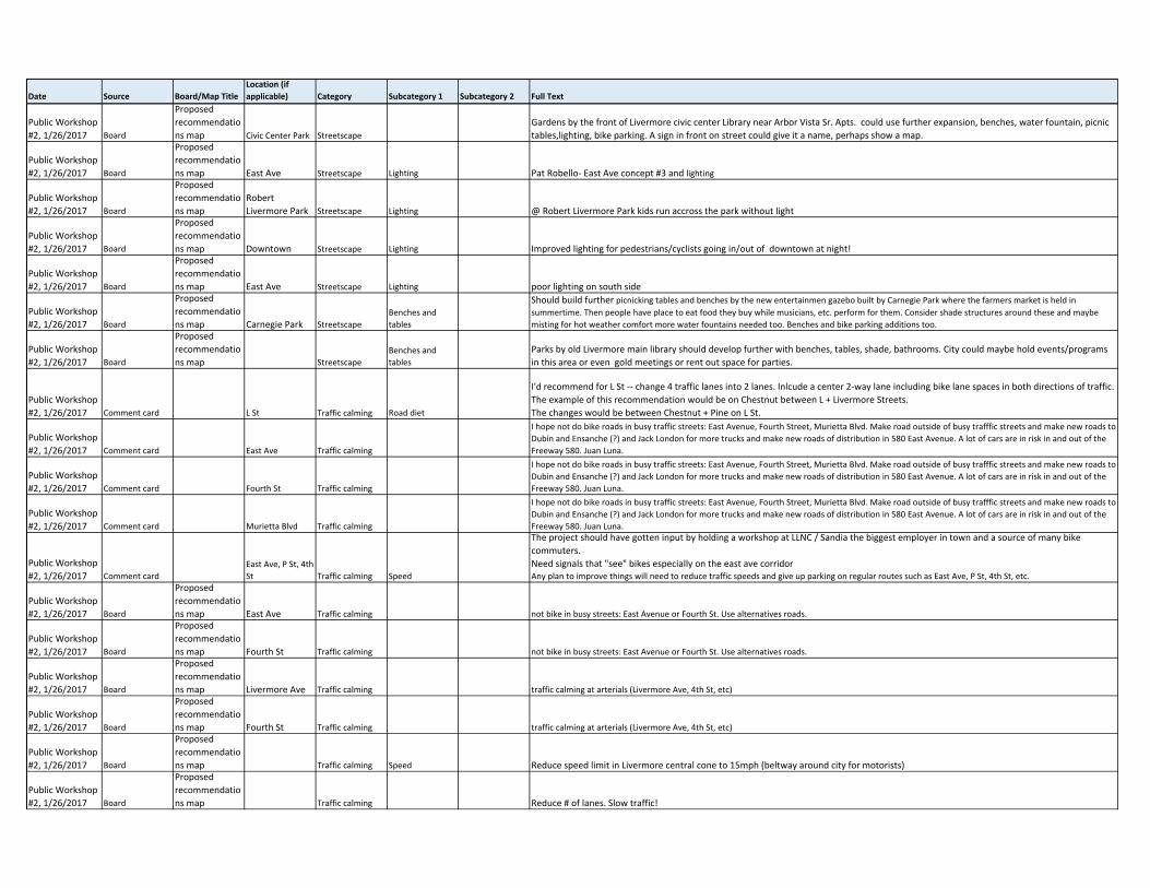
Date Source Board/Map TitleLocation (if applicable) Category Subcategory 1 Subcategory 2 Full Text
Public Workshop
#2, 1/26/2017 Board
Proposed
recommendatio
ns map Civic Center Park Streetscape
Gardens by the front of Livermore civic center Library near Arbor Vista Sr. Apts. could use further expansion, benches, water fountain, picnic
tables,lighting, bike parking. A sign in front on street could give it a name, perhaps show a map.
Public Workshop
#2, 1/26/2017 Board
Proposed
recommendatio
ns map East Ave Streetscape Lighting Pat Robello‐ East Ave concept #3 and lighting
Public Workshop
#2, 1/26/2017 Board
Proposed
recommendatio
ns map
Robert
Livermore Park Streetscape Lighting @ Robert Livermore Park kids run accross the park without light
Public Workshop
#2, 1/26/2017 Board
Proposed
recommendatio
ns map Downtown Streetscape Lighting Improved lighting for pedestrians/cyclists going in/out of downtown at night!
Public Workshop
#2, 1/26/2017 Board
Proposed
recommendatio
ns map East Ave Streetscape Lighting poor lighting on south side
Public Workshop
#2, 1/26/2017 Board
Proposed
recommendatio
ns map Carnegie Park Streetscape
Benches and
tables
Should build further picnicking tables and benches by the new entertainmen gazebo built by Carnegie Park where the farmers market is held in
summertime. Then people have place to eat food they buy while musicians, etc. perform for them. Consider shade structures around these and maybe
misting for hot weather comfort more water fountains needed too. Benches and bike parking additions too.
Public Workshop
#2, 1/26/2017 Board
Proposed
recommendatio
ns map Streetscape
Benches and
tables
Parks by old Livermore main library should develop further with benches, tables, shade, bathrooms. City could maybe hold events/programs
in this area or even gold meetings or rent out space for parties.
Public Workshop
#2, 1/26/2017 Comment card L St Traffic calming Road diet
I'd recommend for L St ‐‐ change 4 traffic lanes into 2 lanes. Inlcude a center 2‐way lane including bike lane spaces in both directions of traffic.
The example of this recommendation would be on Chestnut between L + Livermore Streets.
The changes would be between Chestnut + Pine on L St.
Public Workshop
#2, 1/26/2017 Comment card East Ave Traffic calming
I hope not do bike roads in busy traffic streets: East Avenue, Fourth Street, Murietta Blvd. Make road outside of busy trafffic streets and make new roads to
Dubin and Ensanche (?) and Jack London for more trucks and make new roads of distribution in 580 East Avenue. A lot of cars are in risk in and out of the
Freeway 580. Juan Luna.
Public Workshop
#2, 1/26/2017 Comment card Fourth St Traffic calming
I hope not do bike roads in busy traffic streets: East Avenue, Fourth Street, Murietta Blvd. Make road outside of busy trafffic streets and make new roads to
Dubin and Ensanche (?) and Jack London for more trucks and make new roads of distribution in 580 East Avenue. A lot of cars are in risk in and out of the
Freeway 580. Juan Luna.
Public Workshop
#2, 1/26/2017 Comment card Murietta Blvd Traffic calming
I hope not do bike roads in busy traffic streets: East Avenue, Fourth Street, Murietta Blvd. Make road outside of busy trafffic streets and make new roads to
Dubin and Ensanche (?) and Jack London for more trucks and make new roads of distribution in 580 East Avenue. A lot of cars are in risk in and out of the
Freeway 580. Juan Luna.
Public Workshop
#2, 1/26/2017 Comment card
East Ave, P St, 4th
St Traffic calming Speed
The project should have gotten input by holding a workshop at LLNC / Sandia the biggest employer in town and a source of many bike
commuters.
Need signals that "see" bikes especially on the east ave corridorAny plan to improve things will need to reduce traffic speeds and give up parking on regular routes such as East Ave, P St, 4th St, etc.
Public Workshop
#2, 1/26/2017 Board
Proposed
recommendatio
ns map East Ave Traffic calming not bike in busy streets: East Avenue or Fourth St. Use alternatives roads.
Public Workshop
#2, 1/26/2017 Board
Proposed
recommendatio
ns map Fourth St Traffic calming not bike in busy streets: East Avenue or Fourth St. Use alternatives roads.
Public Workshop
#2, 1/26/2017 Board
Proposed
recommendatio
ns map Livermore Ave Traffic calming traffic calming at arterials (Livermore Ave, 4th St, etc)
Public Workshop
#2, 1/26/2017 Board
Proposed
recommendatio
ns map Fourth St Traffic calming traffic calming at arterials (Livermore Ave, 4th St, etc)
Public Workshop
#2, 1/26/2017 Board
Proposed
recommendatio
ns map Traffic calming Speed Reduce speed limit in Livermore central cone to 15mph (beltway around city for motorists)
Public Workshop
#2, 1/26/2017 Board
Proposed
recommendatio
ns map Traffic calming Reduce # of lanes. Slow traffic!
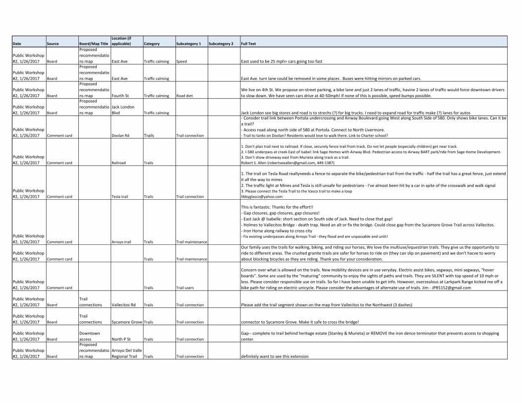
Date Source Board/Map TitleLocation (if applicable) Category Subcategory 1 Subcategory 2 Full Text
Public Workshop
#2, 1/26/2017 Board
Proposed
recommendatio
ns map East Ave Traffic calming Speed East used to be 25 mph> cars going too fast
Public Workshop
#2, 1/26/2017 Board
Proposed
recommendatio
ns map East Ave Traffic calming East Ave. turn lane could be removed in some places . Buses were hitting mirrors on parked cars.
Public Workshop
#2, 1/26/2017 Board
Proposed
recommendatio
ns map Fourth St Traffic calming Road diet
We live on 4th St. We propose on‐street parking, a bike lane and just 2 lanes of traffic, havine 2 lanes of traffic would force downtown drivers
to slow down. We have seen cars drive at 40‐50mph! If none of this is possible, speed bumps possible.
Public Workshop
#2, 1/26/2017 Board
Proposed
recommendatio
ns map
Jack London
Blvd Traffic calming Jack London see big stores and road is to strechs (?) for big trucks. I need to expand road for traffic make (?) lanes for autos
Public Workshop
#2, 1/26/2017 Comment card Doolan Rd Trails Trail connection
‐ Consider trail link between Portola undercrossing and Airway Boulevard going West along South Side of 580. Only shows bike lanes. Can it be
a trail?
‐ Access road along north side of 580 at Portola. Connect to North Livermore.‐ Trail to tanks on Doolan? Residents would love to walk there. Link to Charter school?
Public Workshop
#2, 1/26/2017 Comment card Railroad Trails
1. Don't plan trail next to railroad. If close, securely fence trail from track. Do not let people (especially children) get near track.
2. I‐580 underpass at creek East of Isabel: link Sage Homes with Airway Blvd. Pedestrian access to Airway BART park/ride from Sage Home Development.
3. Don't show driveway east from Murieta along track as a trail.
Robert S. Allen ([email protected], 449‐1387)
Public Workshop
#2, 1/26/2017 Comment card Tesla trail Trails Trail connection
1. The trail on Tesla Road reallyneeds a fence to separate the bike/pedestrian trail from the traffic ‐ half the trail has a great fence, just extend
it all the way to mines
2. The traffic light at Mines and Tesla is still unsafe for pedestrians ‐ I've almost been hit by a car in spite of the crosswalk and walk signal3. Please connect the Tesla Trail to the Vasco trail to make a loop
Public Workshop
#2, 1/26/2017 Comment card Arroyo trail Trails Trail maintenance
This is fantastic. Thanks for the effort!!
‐ Gap closures, gap closures, gap closures!
‐ East Jack @ Isabelle: short section on South side of Jack. Need to close that gap!
‐ Holmes to Vallecitos Bridge ‐ death trap. Need an alt or fix the bridge. Could close gap from the Sycamore Grove Trail across Vallecitos.
‐ Iron Horse along railway to cross city‐ Fix existing underpasses along Arroyo Trail ‐ they flood and are unpassable and unlit!
Public Workshop
#2, 1/26/2017 Comment card Trails Trail maintenance
Our family uses the trails for walking, biking, and riding our horses, We love the multiuse/equestrian trails. They give us the opportunity to
ride to different areas. The crushed granite trails are safer for horses to ride on (they can slip on pavement) and we don't hacve to worry
about blocking bicycles as they are riding. Thank you for your consideration.
Public Workshop
#2, 1/26/2017 Comment card Trails Trail users
Concern over what is allowed on the trails. New mobility devices are in use veryday. Electric assist bikes, segways, mini segways, "hover
boards". Some are used by the "maturing" community to enjoy the sights of paths and trails. They are SILENT with top speed of 10 mph or
less. Please consider responsible use on trails. So far I have been unable to get info. However, overzealous at Larkpark Range kicked me off a
bike path for riding on electric unicycle. Please consider the advantages of alternate use of trails. Jim ‐ [email protected]
Public Workshop
#2, 1/26/2017 Board
Trail
connections Vallecitos Rd Trails Trail connection Please add the trail segment shown on the map from Vallecitos to the Northwest (3 dashes)
Public Workshop
#2, 1/26/2017 Board
Trail
connections Sycamore Grove Trails Trail connection connector to Sycamore Grove. Make it safe to cross the bridge!
Public Workshop
#2, 1/26/2017 Board
Downtown
access North P St Trails Trail connection
Gap‐‐ complete to trail behind heritage estate (Stanley & Murieta) or REMOVE the iron dence terminator that prevents access to shopping
center.
Public Workshop
#2, 1/26/2017 Board
Proposed
recommendatio
ns map
Arroyo Del Valle
Regional Trail Trails Trail connection definitely want to see this extension
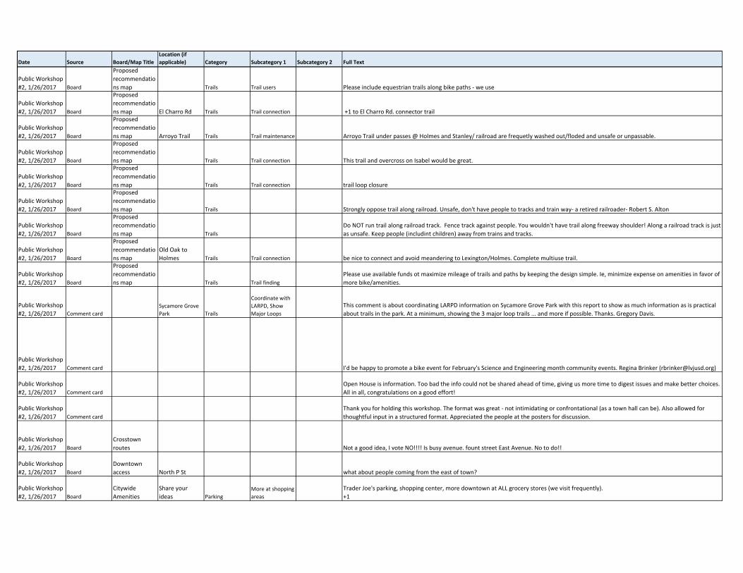
Date Source Board/Map TitleLocation (if applicable) Category Subcategory 1 Subcategory 2 Full Text
Public Workshop
#2, 1/26/2017 Board
Proposed
recommendatio
ns map Trails Trail users Please include equestrian trails along bike paths ‐ we use
Public Workshop
#2, 1/26/2017 Board
Proposed
recommendatio
ns map El Charro Rd Trails Trail connection +1 to El Charro Rd. connector trail
Public Workshop
#2, 1/26/2017 Board
Proposed
recommendatio
ns map Arroyo Trail Trails Trail maintenance Arroyo Trail under passes @ Holmes and Stanley/ railroad are frequetly washed out/floded and unsafe or unpassable.
Public Workshop
#2, 1/26/2017 Board
Proposed
recommendatio
ns map Trails Trail connection This trail and overcross on Isabel would be great.
Public Workshop
#2, 1/26/2017 Board
Proposed
recommendatio
ns map Trails Trail connection trail loop closure
Public Workshop
#2, 1/26/2017 Board
Proposed
recommendatio
ns map Trails Strongly oppose trail along railroad. Unsafe, don't have people to tracks and train way‐ a retired railroader‐ Robert S. Alton
Public Workshop
#2, 1/26/2017 Board
Proposed
recommendatio
ns map Trails
Do NOT run trail along railroad track. Fence track against people. You wouldn't have trail along freeway shoulder! Along a railroad track is just
as unsafe. Keep people (includint children) away from trains and tracks.
Public Workshop
#2, 1/26/2017 Board
Proposed
recommendatio
ns map
Old Oak to
Holmes Trails Trail connection be nice to connect and avoid meandering to Lexington/Holmes. Complete multiuse trail.
Public Workshop
#2, 1/26/2017 Board
Proposed
recommendatio
ns map Trails Trail finding
Please use available funds ot maximize mileage of trails and paths by keeping the design simple. Ie, minimize expense on amenities in favor of
more bike/amenities.
Public Workshop
#2, 1/26/2017 Comment card
Sycamore Grove
Park Trails
Coordinate with
LARPD, Show
Major Loops
This comment is about coordinating LARPD information on Sycamore Grove Park with this report to show as much information as is practical
about trails in the park. At a minimum, showing the 3 major loop trails ... and more if possible. Thanks. Gregory Davis.
Public Workshop
#2, 1/26/2017 Comment card I'd be happy to promote a bike event for February's Science and Engineering month community events. Regina Brinker ([email protected])
Public Workshop
#2, 1/26/2017 Comment card
Open House is information. Too bad the info could not be shared ahead of time, giving us more time to digest issues and make better choices.
All in all, congratulations on a good effort!
Public Workshop
#2, 1/26/2017 Comment card
Thank you for holding this workshop. The format was great ‐ not intimidating or confrontational (as a town hall can be). Also allowed for
thoughtful input in a structured format. Appreciated the people at the posters for discussion.
Public Workshop
#2, 1/26/2017 Board
Crosstown
routes Not a good idea, I vote NO!!!! Is busy avenue. fount street East Avenue. No to do!!
Public Workshop
#2, 1/26/2017 Board
Downtown
access North P St what about people coming from the east of town?
Public Workshop
#2, 1/26/2017 Board
Citywide
Amenities
Share your
ideas Parking
More at shopping
areas
Trader Joe's parking, shopping center, more downtown at ALL grocery stores (we visit frequently).
+1
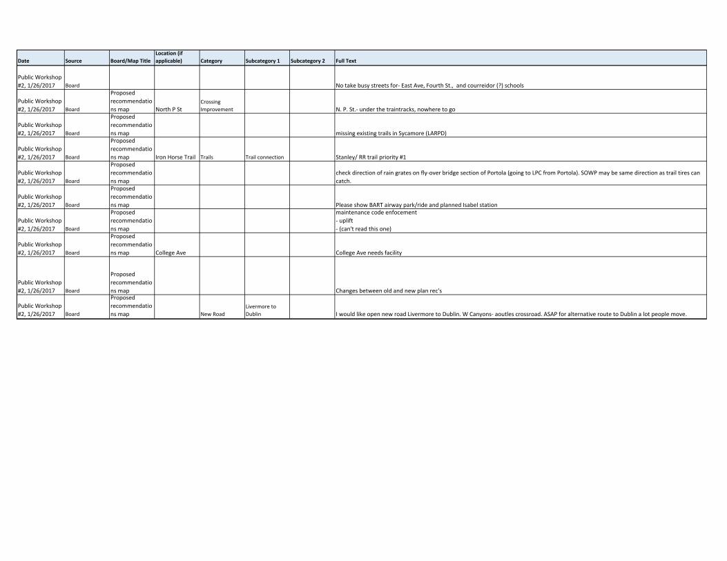
Date Source Board/Map TitleLocation (if applicable) Category Subcategory 1 Subcategory 2 Full Text
Public Workshop
#2, 1/26/2017 Board No take busy streets for‐ East Ave, Fourth St., and courreidor (?) schools
Public Workshop
#2, 1/26/2017 Board
Proposed
recommendatio
ns map North P StCrossing
Improvement N. P. St.‐ under the traintracks, nowhere to go
Public Workshop
#2, 1/26/2017 Board
Proposed
recommendatio
ns map missing existing trails in Sycamore (LARPD)
Public Workshop
#2, 1/26/2017 Board
Proposed
recommendatio
ns map Iron Horse Trail Trails Trail connection Stanley/ RR trail priority #1
Public Workshop
#2, 1/26/2017 Board
Proposed
recommendatio
ns map
check direction of rain grates on fly‐over bridge section of Portola (going to LPC from Portola). SOWP may be same direction as trail tires can
catch.
Public Workshop
#2, 1/26/2017 Board
Proposed
recommendatio
ns map Please show BART airway park/ride and planned Isabel station
Public Workshop
#2, 1/26/2017 Board
Proposed
recommendatio
ns map
maintenance code enfocement
‐ uplift
‐ (can't read this one)
Public Workshop
#2, 1/26/2017 Board
Proposed
recommendatio
ns map College Ave College Ave needs facility
Public Workshop
#2, 1/26/2017 Board
Proposed
recommendatio
ns map Changes between old and new plan rec's
Public Workshop
#2, 1/26/2017 Board
Proposed
recommendatio
ns map New Road
Livermore to
Dublin I would like open new road Livermore to Dublin. W Canyons‐ aoutles crossroad. ASAP for alternative route to Dublin a lot people move.