Embed Size (px)
Citation preview

Local Plan, Part 1: Core Strategy Proposed Changes to Proposals Map August 2015
© Crown copyright and database rights (2015) Ordnance Survey (100024913)
All maps and diagrams in this document are indicative and have not been produced to a standard scale

Changes to Proposals Map:
The Proposals Map forms part of Derby’s Local Plan and identifies the areas of the City that are subject to policies and proposals contained within Development Plan Documents. The Proposals Map currently shows the saved policies and proposals contained in the City of Derby Local Plan Review (CDLPR), adopted in 2006. It includes policies and proposals for certain sites or areas for uses such as housing, employment, open space and regeneration. This document sets out proposed changes to Derby’s Proposals Map which will arise from the adoption of new policies and proposals contained in the Local Plan Part 1, Core Strategy. Changes include:
the deletion of existing allocations where they are no longer relevant
updated / amended boundaries of features that have changed since the CDLPR was adopted
the inclusion of boundaries for new / amended policy designations All of the proposed amendments are listed against the relevant CDLPR policies in the ‘policy matrix’ in the Appendix. In some cases, the designations set out on the Proposals Map will be retained but the Policy to which the designation relates will be changed. The ‘policy matrix’ also provides a cross reference to the relevant policies where this applies. The following section includes a number of maps showing what changes will be made to the Proposals Map once the Local Plan Part 1, Core Strategy is adopted. The maps are broadly arranged to reflect the order in which affected policy designations are set out in the CDLPR. However, in many cases, more than one proposed amendment is shown on the same map. A number of amendments were made to the Proposals Map in 2009 in order to reflect the policies of the CDLPR that were not ‘saved’ through the transition to the new planning system as set out in the Planning and Compulsory Purchase Act 2004. Allocations deleted from the Proposals Map in 2009 included:
CC5 – Castlefields Main Centre (Westfield)
H5 – West Chellaston
H7 – Heatherton, Littleover
H8 – Land to the West of former Rolls-Royce Training Centre, Station Road, Mickleover
H10 – West Chellaston
LE7 – City Hospital, Mickleover
This page is left intentionally blank

Proposed Amendments and Deletions of City Of Derby Local Plan Review (CDLPR) Allocations:
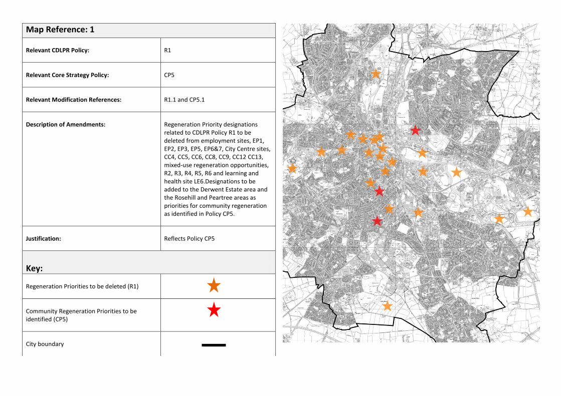
Map Reference: 1
Relevant CDLPR Policy:
R1
Relevant Core Strategy Policy:
CP5
Relevant Modification References:
R1.1 and CP5.1
Description of Amendments:
Regeneration Priority designations related to CDLPR Policy R1 to be deleted from employment sites, EP1, EP2, EP3, EP5, EP6&7, City Centre sites, CC4, CC5, CC6, CC8, CC9, CC12 CC13, mixed-use regeneration opportunities, R2, R3, R4, R5, R6 and learning and health site LE6.Designations to be added to the Derwent Estate area and the Rosehill and Peartree areas as priorities for community regeneration as identified in Policy CP5.
Justification:
Reflects Policy CP5
Key:
Regeneration Priorities to be deleted (R1)
Community Regeneration Priorities to be identified (CP5)
City boundary

Map Reference: 2
Relevant CDLPR Policy:
R4
Relevant Core Strategy Policy:
AC19
Relevant Modification References:
R4.1, AC19.1
Description of Amendments:
Inclusion of revised boundary
Justification:
To reflect developable area and extent of planning permission
Key:
Extent of allocation to be deleted (R4)
Extent of allocation to be identified (AC19)
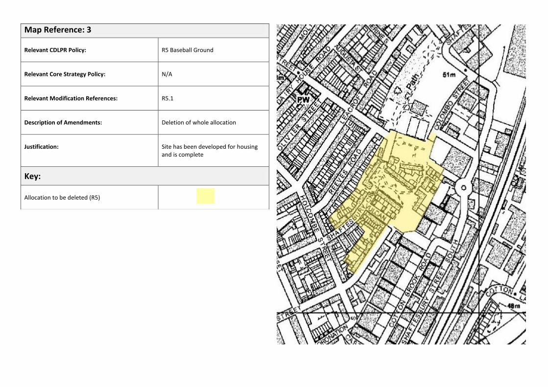
Map Reference: 3
Relevant CDLPR Policy:
R5 Baseball Ground
Relevant Core Strategy Policy:
N/A
Relevant Modification References:
R5.1
Description of Amendments:
Deletion of whole allocation
Justification:
Site has been developed for housing and is complete
Key:
Allocation to be deleted (R5)

Map Reference: 4
Relevant CDLPR Policy:
R6
Relevant Core Strategy Policy:
AC10
Relevant Modification References:
R6.1, AC10.1
Description of Amendments:
Revised boundary
Justification:
To reflect area covered by the Darley Abbey Mills Masterplan
Key:
Extent of allocation to be deleted (R6)
Extent of allocation to be identified (AC10)
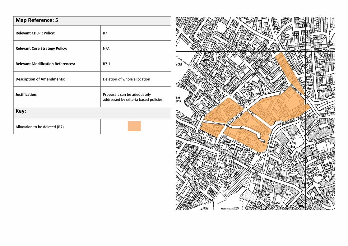
Map Reference: 5
Relevant CDLPR Policy:
R7
Relevant Core Strategy Policy:
N/A
Relevant Modification References:
R7.1
Description of Amendments:
Deletion of whole allocation
Justification:
Proposals can be adequately addressed by criteria based policies
Key:
Allocation to be deleted (R7)

Map Reference: 6
Relevant CDLPR Policy:
CC2
Relevant Core Strategy Policy:
AC2, AC3
Relevant Modification References:
CC2.1, AC2.1
Description of Amendments:
‘City Centre Shopping Area’ allocation replaced with ‘Core Area’ allocation
Justification:
Reflects extent of Core Area referenced in Policy AC2
Key:
Extent of allocation to be deleted (CC2)
Extent of Core Area to be identified (AC2)
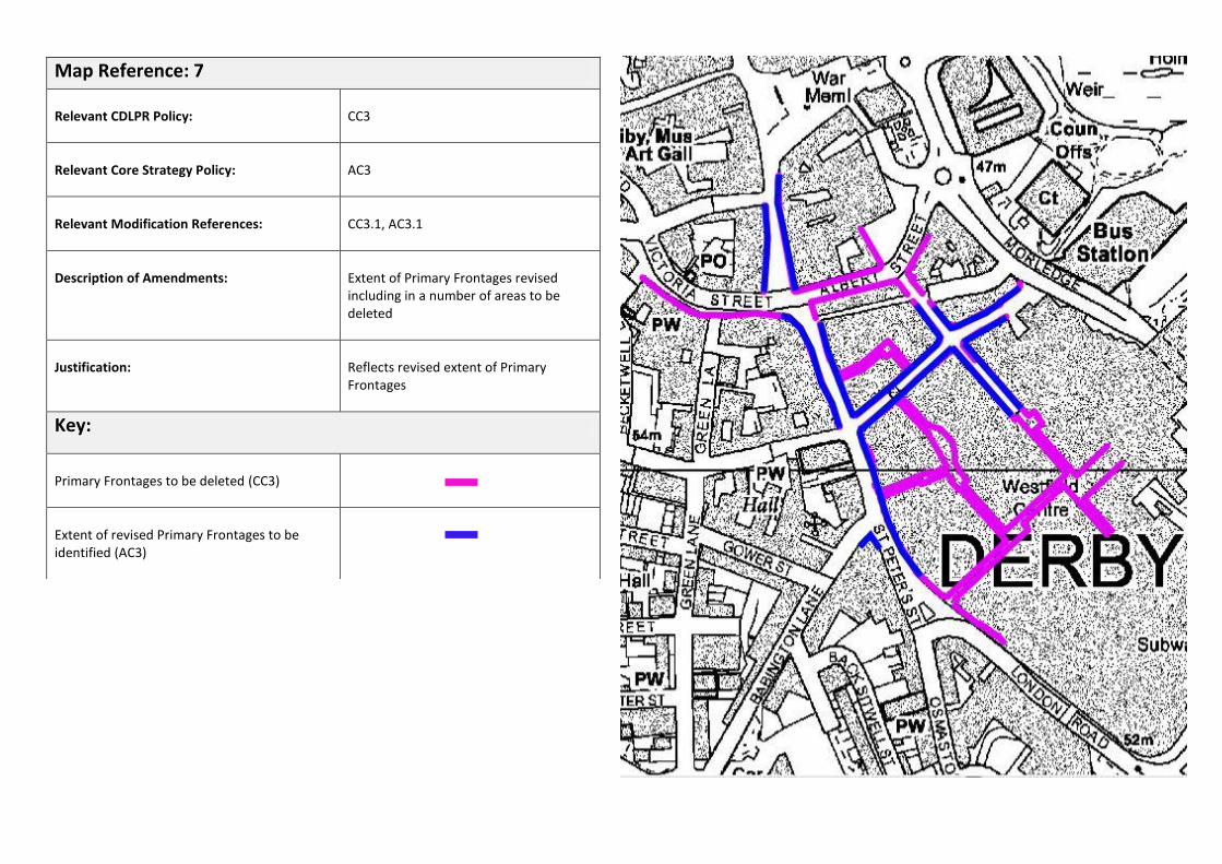
Map Reference: 7
Relevant CDLPR Policy:
CC3
Relevant Core Strategy Policy:
AC3
Relevant Modification References:
CC3.1, AC3.1
Description of Amendments:
Extent of Primary Frontages revised including in a number of areas to be deleted
Justification:
Reflects revised extent of Primary Frontages
Key:
Primary Frontages to be deleted (CC3)
Extent of revised Primary Frontages to be identified (AC3)

Map Reference: 8
Relevant CDLPR Policies:
CC8, CC9, CC10, CC11
Relevant Core Strategy Policies:
AC1, AC2, AC3
Relevant Modification References:
AC2.2, CC8.1, CC9.1, CC10.1, CC11.1
Description of Amendments:
Various City Centre site allocations to be deleted and replaced with identification of new ‘Quarters’
Justification:
The principle of regenerating the sites / areas identified is addressed through the identification of specific ‘Quarters’ in Policy AC2. The detail of specific sites will be reviewed in the Local Plan Part 2.
Key:
New ‘Quarters’ allocations to be identified (AC1, A2, AC3)
Allocations to be deleted (CC8, CC9, CC10, CC11)
Castleward
intu
St Peter’s
Riverside Cathedral
CC9
CC8
CC11
CC10

Map Reference: 9
Relevant CDLPR Policy:
CC13, CC14
Relevant Core Strategy Policy:
AC6
Relevant Modification References:
CC13.1, CC14.1, AC6.1
Description of Amendments:
Deletion of allocations CC13and CC14 and replacement with new allocation covering all of the Castleward area.
Justification:
Site has been identified for housing development in the Local Plan Part 1
Key:
Extent of allocation to be deleted (CC13)
Extent of allocation to be deleted (CC14)
Extent of allocation to be identified (AC6)

Map Reference: 10
Relevant CDLPR Policy:
CC18
Relevant Core Strategy Policy:
AC4
Relevant Modification References:
CC18.1
Description of Amendments:
Allocation to be deleted
Justification:
Boundary not relevant to revised policy
Key:
Allocation to be deleted (CC18)

Map Reference: 11
Relevant CDLPR Policy:
H2 (a), (c), (d), (e), (f)
Relevant Core Strategy Policy:
N/A
Relevant Modification References:
H2.1
Description of Amendments:
Allocations to be deleted
Justification:
Sites have been developed for housing – policy has been implemented
Key:
Allocations to be deleted (H2a, b, c, d, e, f)
H2 (d)
H2 (f)
H2 (e)
H2 (c)
H2 (a)
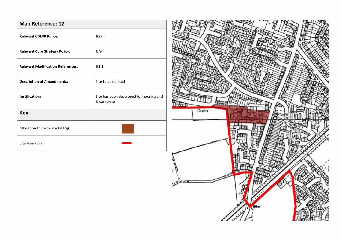
Map Reference: 12
Relevant CDLPR Policy:
H2 (g)
Relevant Core Strategy Policy:
N/A
Relevant Modification References:
H2.1
Description of Amendments:
Site to be deleted
Justification:
Site has been developed for housing and is complete
Key:
Allocation to be deleted (H2g)
City boundary

Map Reference: 13
Relevant CDLPR Policy:
H2 (h), H3 (b)
Relevant Core Strategy Policy:
N/A
Relevant Modification References:
H2.1, H3.1
Description of Amendments:
Allocations to be deleted
Justification:
Sites have been developed for housing – policy has been implemented
Key:
Allocation to be deleted (H2h)
H2h
H3b

Map Reference: 14
Relevant CDLPR Policy:
H4
Relevant Core Strategy Policy:
N/A
Relevant Modification References:
H4.1
Description of Amendments:
Allocation to be deleted
Justification:
Site has been developed for housing – policy has been implemented
Key:
Allocation to be deleted (H4)

Map Reference: 15
Relevant CDLPR Policy:
H6
Relevant Core Strategy Policy:
N/A
Relevant Modification References:
H6.1
Description of Amendments:
Deletion of whole allocation
Justification:
Site has been developed for housing and is complete.
Key:
Allocation to be deleted (H6)

Map Reference: 16
Relevant CDLPR Policies:
EP3, EP11
Relevant Core Strategy Policy:
CP10
Relevant Modification References:
EP3.1, EP11.1
Description of Amendments:
Area EP3 (a) to be deleted and identified as existing employment land. Areas (b) and (c) to be maintained as part of EP3 allocation.
Justification:
Area EP3 (a) has been developed for predominantly employment uses. Area (b) has been developed for mainly education uses and has been identified as a Higher Education Campus in Policy CP22. Employment would still be acceptable in this area and therefore it will be maintained in EP3 as well. Area EP3 (c) has been developed for leisure uses. The approach to this area will be reviewed in the Local Plan Part 2.
Key:
Areas retained as proposed employment land (EP3)
Area to be deleted from EP3 and identified as existing employment land (CP10)
EP3 (c)
EP3 (a)
EP3 (b)

Map Reference: 17
Relevant CDLPR Policy:
EP5
Relevant Core Strategy Policy:
CP10
Relevant Modification References:
EP5.2, EP11.2
Description of Amendments:
Site deleted from EP5 and identified as existing employment land
Justification:
Site has been developed predominantly for employment uses during the Plan period.
Key:
Area to be deleted from EP5 and identified as existing employment land (CP10)

Map Reference: 18
Relevant CDLPR Policy:
EP8 (a)
Relevant Core Strategy Policy:
CP10
Relevant Modification References:
EP8.1, EP11.3
Description of Amendments:
Extent of Wyvern Business Park to be deleted from EP8 (a) and identified as existing employment land.
Justification:
Site has been developed for employment uses.
Key:
Area to be deleted from EP8 and identified as existing employment land (CP10)
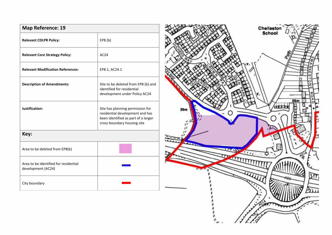
Map Reference: 19
Relevant CDLPR Policy:
EP8 (b)
Relevant Core Strategy Policy:
AC24
Relevant Modification References:
EP8.1, AC24.1
Description of Amendments:
Site to be deleted from EP8 (b) and identified for residential development under Policy AC24
Justification:
Site has planning permission for residential development and has been identified as part of a larger cross boundary housing site
Key:
Area to be deleted from EP8(b)
Area to be identified for residential development (AC24)
City boundary

Existing:
Proposed:
Area to be deleted from EP9(b) and identified as existing employment land (CP10)
Map Reference: 20
Relevant CDLPR Policies:
EP9(b), S8 and EP11
Relevant Core Strategy Policy:
CP10, CP13
Relevant Modification References:
EP9.1, S8.1, S8.2, EP11.9, EP11.12
Description of Amendments:
Extent of EP9 (b) allocation to be split, with the southern extent identified as part of the adjacent out-of-centre retail park and the western extent identified as existing employment land. Area of existing land to also be included as part of the retail park.
Justification:
The southern part of the proposed employment allocation and the area of existing employment land has been developed for a large B&Q Warehouse (A1). The western portion of the site has been developed for business units.
Key:
Extent of retail park allocation S8 / CP13
Existing employment land
Extent of EP9 (b) allocation
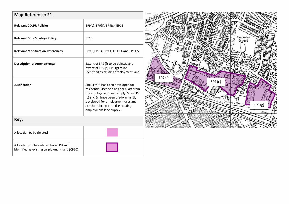
Map Reference: 21
Relevant CDLPR Policies:
EP9(c), EP9(f), EP9(g), EP11
Relevant Core Strategy Policy:
CP10
Relevant Modification References:
EP9.2,EP9.3, EP9.4, EP11.4 and EP11.5
Description of Amendments:
Extent of EP9 (f) to be deleted and extent of EP9 (c) EP9 (g) to be identified as existing employment land.
Justification:
Site EP9 (f) has been developed for residential uses and has been lost from the employment land supply. Sites EP9 (c) and (g) have been predominantly developed for employment uses and are therefore part of the existing employment land supply.
Key:
Allocation to be deleted
Allocations to be deleted from EP9 and identified as existing employment land (CP10)
EP9 (f) EP9 (c)
EP9 (g)

Map Reference: 22
Relevant CDLPR Policies:
EP9(h), EP11
Relevant Core Strategy Policy:
CP10
Relevant Modification References:
EP9.5
Description of Amendments:
Deletion of allocation
Justification:
Site has been developed for a non B use (car showroom).
Key:
Allocation to be deleted
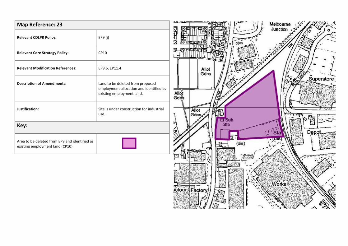
Map Reference: 23
Relevant CDLPR Policy:
EP9 (j)
Relevant Core Strategy Policy:
CP10
Relevant Modification References:
EP9.6, EP11.4
Description of Amendments:
Land to be deleted from proposed employment allocation and identified as existing employment land.
Justification:
Site is under construction for industrial use.
Key:
Area to be deleted from EP9 and identified as existing employment land (CP10)
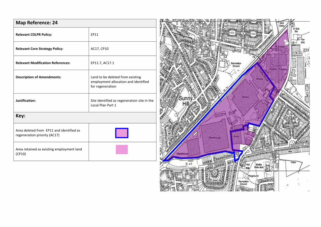
Map Reference: 24
Relevant CDLPR Policy:
EP11
Relevant Core Strategy Policy:
AC17, CP10
Relevant Modification References:
EP11.7, AC17.1
Description of Amendments:
Land to be deleted from existing employment allocation and identified for regeneration
Justification:
Site identified as regeneration site in the Local Plan Part 1
Key:
Area deleted from EP11 and identified as regeneration priority (AC17)
Area retained as existing employment land (CP10)

Map Reference: 25
Relevant CDLPR Policy:
EP11, H3 (a)
Relevant Core Strategy Policy:
AC14
Relevant Modification References:
EP11.8
Description of Amendments:
Existing employment areas and housing allocation to be deleted. Osmaston Regeneration area to be identified.
Justification:
Sites no longer in employment use and no longer required by Rolls- Royce. Whole Osmaston area identified for residential led regeneration including the Main Works site on Nightingale Road. Housing allocation on Glossop Street now under construction
Key:
Areas of existing employment land to be deleted (EP11)
Housing allocation to be deleted (H3a)
Extent of Osmaston Regeneration Area to be identified

Map Reference: 26
Relevant CDLPR Policy:
EP11
Relevant Core Strategy Policy:
AC13
Relevant Modification References:
EP11.10, AC13.1
Description of Amendments:
Land to be deleted from EP11 and identified as a regeneration site.
Justification:
The majority of the site is now vacant and has significant potential to be redeveloped for beneficial uses. The site is identified by Policy AC13 which allows the site to be developed for a range of different uses, subject to various criteria being met.
Key:
Area to be deleted from EP11 and identified as regeneration priority (AC13)
Area retained as existing employment land (CP10)
Area retained as Green Wedge

Map Reference: 27
Relevant CDLPR Policy:
EP11
Relevant Core Strategy Policy:
AC16
Relevant Modification References:
EP11.11, AC16.1
Description of Amendments:
Rolls-Royce land ownership in the Wilmore Road area to deleted from generic EP11 allocation and identified as Derby Aerospace Campus allocation - Policy AC16
Justification:
The Derby Aerospace Campus area has been elevated from the standard EP11 allocation to reflect the global importance of the area and to provide support to any future proposals that deliver improvement of this area.
Key:
Area to be deleted from EP11 and identified as Derby Aerospace Campus – regeneration priority (AC16)
Area retained as existing employment land (CP10)
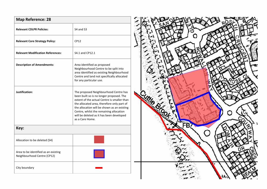
Map Reference: 28
Relevant CDLPR Policies:
S4 and S3
Relevant Core Strategy Policy:
CP12
Relevant Modification References:
S4.1 and CP12.1
Description of Amendments:
Area identified as proposed Neighbourhood Centre to be split into area identified as existing Neighbourhood Centre and land not specifically allocated for any particular use.
Justification:
The proposed Neighbourhood Centre has been built so is no longer proposed. The extent of the actual Centre is smaller than the allocated area, therefore only part of the allocation will be shown as an existing Centre, whilst the remaining allocation will be deleted as it has been developed as a Care Home.
Key:
Allocation to be deleted (S4)
Area to be identified as an existing Neighbourhood Centre (CP12)
City boundary

Map Reference: 29
Relevant CDLPR Policies:
E2, E4, L4
Relevant Core Strategy Policies:
AC21, AC22, CP18
Relevant Modification References:
L4.1, E2.1, E2.2, E2.3, L4.1, AC21.1, AC22.1, AC22.2
Description of Amendments:
Land to be deleted from Green Wedge and Proposed Public Open Space allocation and identified for residential development. Site of Importance for Nature Conservation also to be deleted. Remainder of Hackwood Farm allocation outside of the Green Wedge to be identified
Justification:
Sites have been identified as housing sites in the Local Plan Part 1. Site of Importance for Nature Conservation no longer meets DWT selection criteria
Key:
City boundary
Areas to be deleted from Green Wedge (E2) and identified for residential development (AC21, AC22)
Area to be deleted from Green Wedge (E2) and Proposed Public Open Space (L4) allocations and identified for residential development (AC22)
Areas retained as Green Wedge (CP18)
Areas retained as Proposed Public Open Space (L4)
Nature Conservation Site to be deleted (E4)
Area identified for residential development (AC21)

Map Reference: 30
Relevant CDLPR Policy:
E2
Relevant Core Strategy Policy:
AC23, CP18
Relevant Modification References:
E2.4, E2.5, AC23.1
Description of Amendments:
Land on the eastern and western sides of Boulton Moor to be deleted from Green Wedge allocation.
Justification:
Sites have been identified as housing sites in the Local Plan Part 1.
Key:
City boundary
Areas to be deleted from Green Wedge allocations (E2) and identified for residential development (AC23)
Areas retained as Green Wedge (CP18)
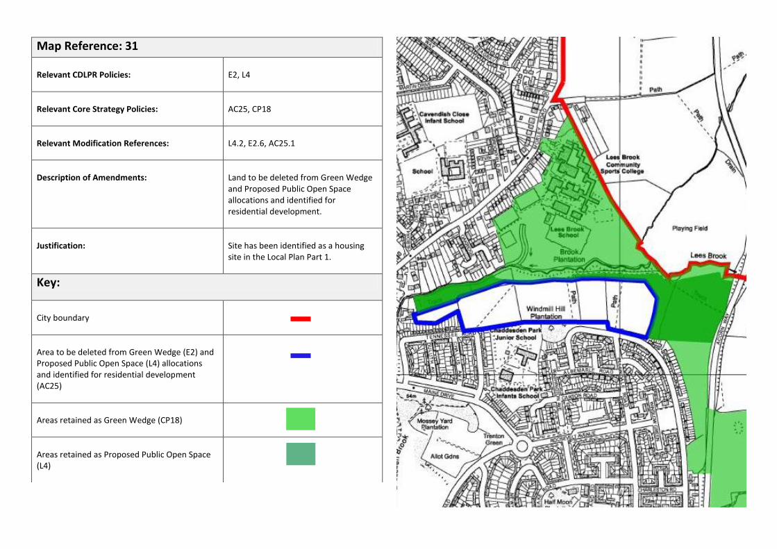
Map Reference: 31
Relevant CDLPR Policies:
E2, L4
Relevant Core Strategy Policies:
AC25, CP18
Relevant Modification References:
L4.2, E2.6, AC25.1
Description of Amendments:
Land to be deleted from Green Wedge and Proposed Public Open Space allocations and identified for residential development.
Justification:
Site has been identified as a housing site in the Local Plan Part 1.
Key:
City boundary
Area to be deleted from Green Wedge (E2) and Proposed Public Open Space (L4) allocations and identified for residential development (AC25)
Areas retained as Green Wedge (CP18)
Areas retained as Proposed Public Open Space (L4)
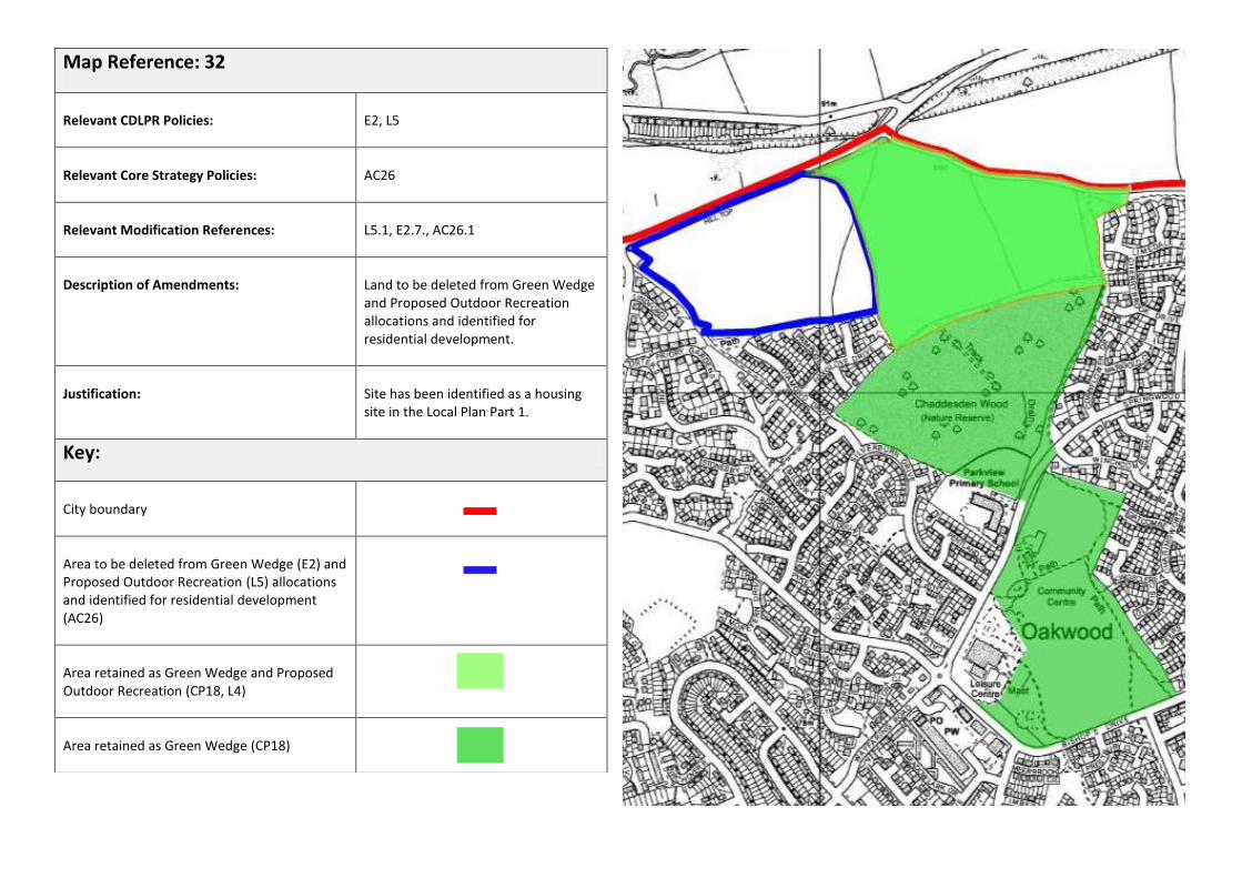
Map Reference: 32
Relevant CDLPR Policies:
E2, L5
Relevant Core Strategy Policies:
AC26
Relevant Modification References:
L5.1, E2.7., AC26.1
Description of Amendments:
Land to be deleted from Green Wedge and Proposed Outdoor Recreation allocations and identified for residential development.
Justification:
Site has been identified as a housing site in the Local Plan Part 1.
Key:
City boundary
Area to be deleted from Green Wedge (E2) and Proposed Outdoor Recreation (L5) allocations and identified for residential development (AC26)
Area retained as Green Wedge and Proposed Outdoor Recreation (CP18, L4)
Area retained as Green Wedge (CP18)

Map Reference: 33
Relevant CDLPR Policy: E18
Relevant Core Strategy Policy: CP20
Relevant Modification References: E18.1
Description of Amendments: Revision to City centre Conservation Area
Justification: To reflect changes to the boundary that have occurred during the Plan period of the CDLPR. Conservation Area boundaries are reviewed through a separate process to plan making.
Key:
Previous extent of City Centre Conservation Area (E18) to be deleted
Revised extent of City Centre ConservationArea to be identified (CP20)

Map Reference: 34
Relevant CDLPR Policy: E18
Relevant Core Strategy Policy: CP20
Relevant Modification References: E18.1
Description of Amendments: Revision to Friar Gate Conservation Area
Justification: To reflect changes to the boundary that have occurred during the Plan period of the CDLPR. Conservation Area boundaries are reviewed through a separate process to plan making.
Key:
Previous extent of Friar Gate Conservation Area (E18) to be deleted
Revised extent of Friar Gate Conservation Area to be identified (CP20)
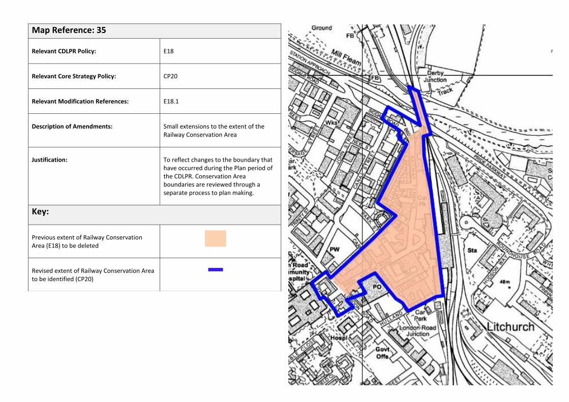
Map Reference: 35
Relevant CDLPR Policy: E18
Relevant Core Strategy Policy: CP20
Relevant Modification References: E18.1
Description of Amendments: Small extensions to the extent of the Railway Conservation Area
Justification: To reflect changes to the boundary that have occurred during the Plan period of the CDLPR. Conservation Area boundaries are reviewed through a separate process to plan making.
Key:
Previous extent of Railway Conservation Area (E18) to be deleted
Revised extent of Railway Conservation Area to be identified (CP20)
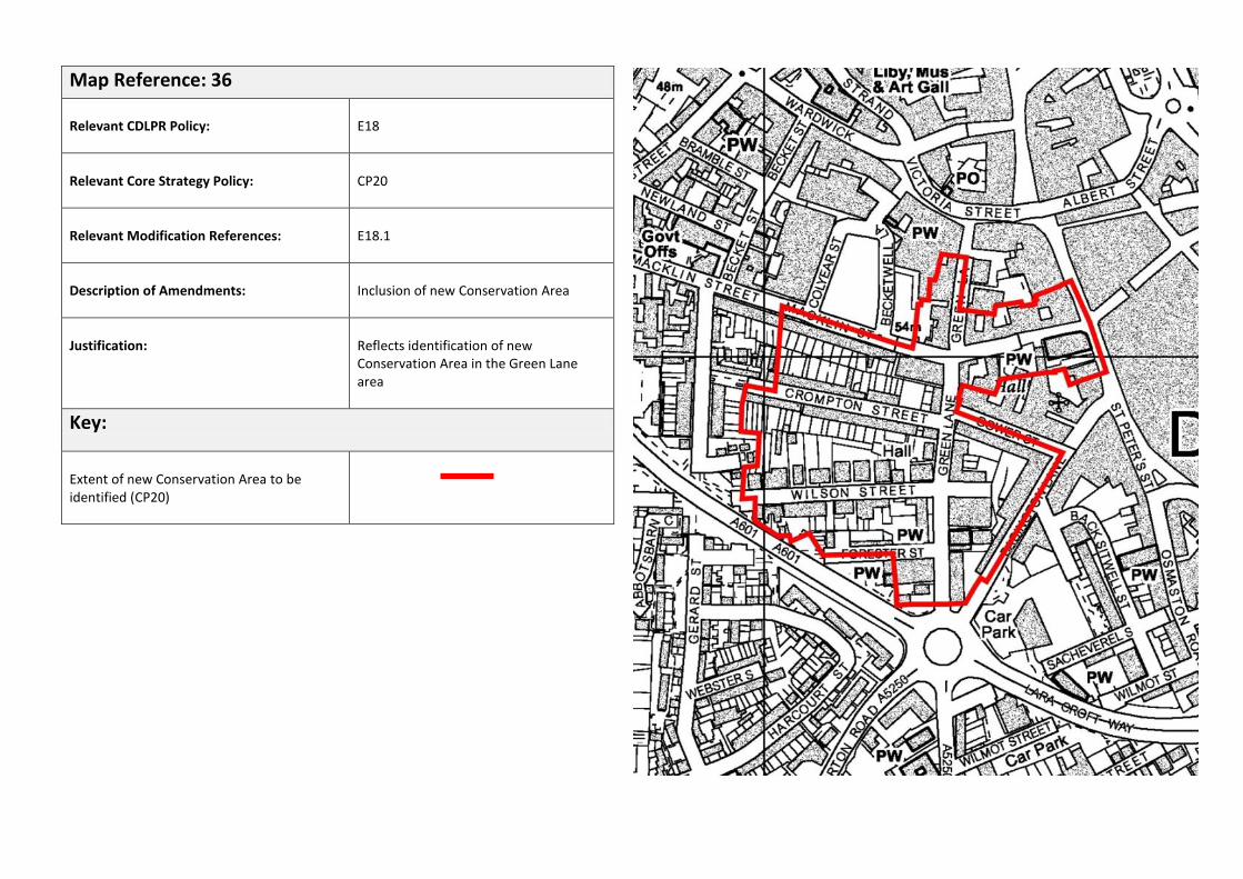
Map Reference: 36
Relevant CDLPR Policy: E18
Relevant Core Strategy Policy: CP20
Relevant Modification References: E18.1
Description of Amendments: Inclusion of new Conservation Area
Justification: Reflects identification of new Conservation Area in the Green Lane area
Key:
Extent of new Conservation Area to be identified (CP20)

Map Reference: 37
Relevant CDLPR Policy:
LE5
Relevant Core Strategy Policy:
N/A
Relevant Modification References:
LE5.1
Description of Amendments:
Deletion of allocation
Justification:
Site has been completed for residential development and is complete
Key:
Allocation to be deleted (LE5)
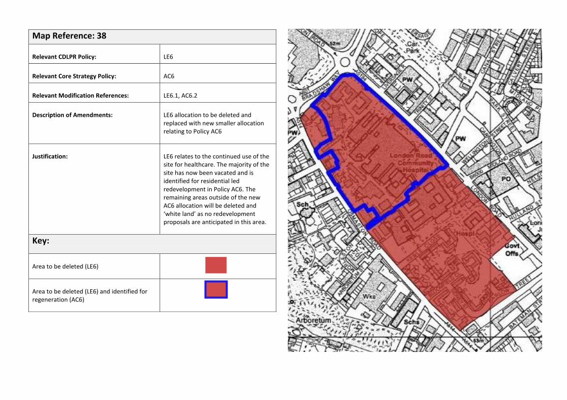
Map Reference: 38
Relevant CDLPR Policy:
LE6
Relevant Core Strategy Policy:
AC6
Relevant Modification References:
LE6.1, AC6.2
Description of Amendments:
LE6 allocation to be deleted and replaced with new smaller allocation relating to Policy AC6
Justification:
LE6 relates to the continued use of the site for healthcare. The majority of the site has now been vacated and is identified for residential led redevelopment in Policy AC6. The remaining areas outside of the new AC6 allocation will be deleted and ‘white land’ as no redevelopment proposals are anticipated in this area.
Key:
Area to be deleted (LE6)
Area to be deleted (LE6) and identified for regeneration (AC6)
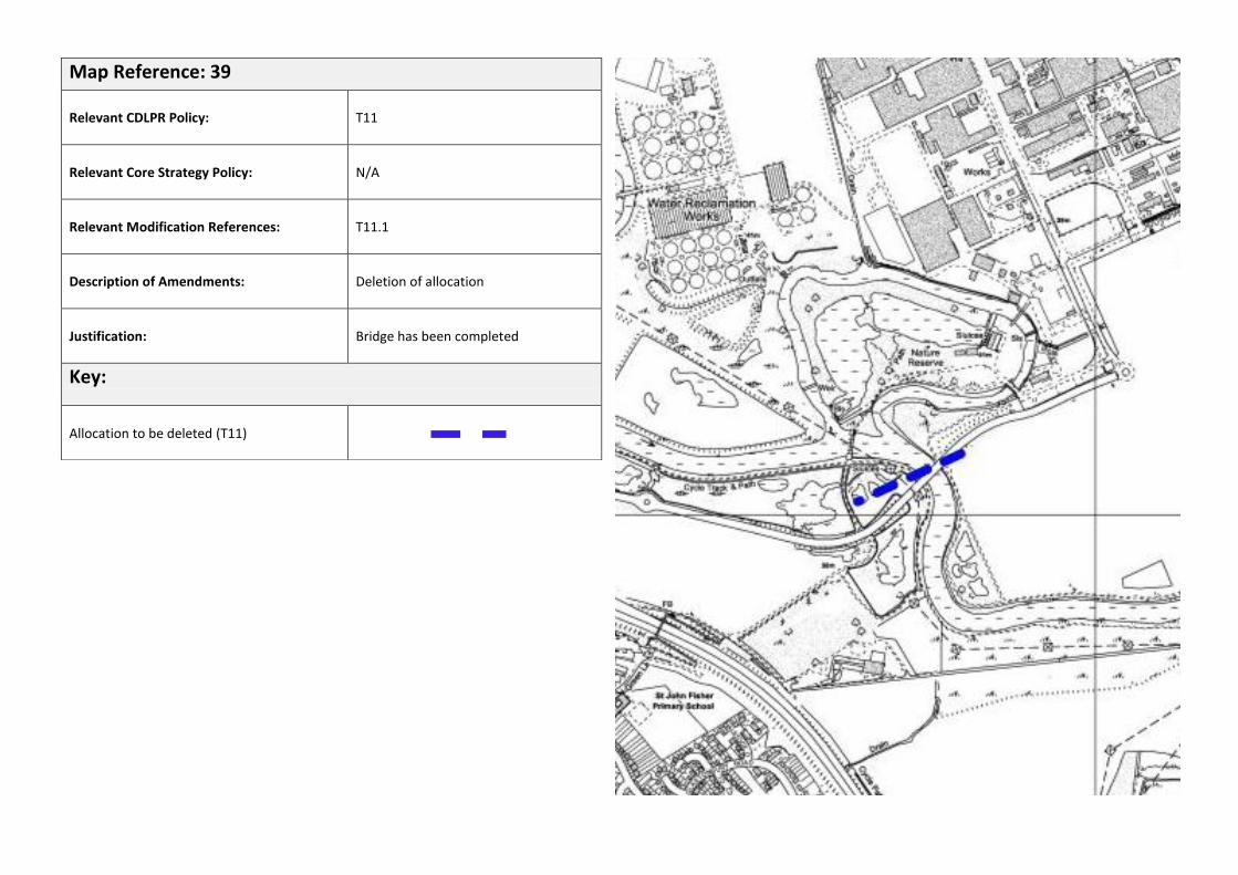
Map Reference: 39
Relevant CDLPR Policy:
T11
Relevant Core Strategy Policy:
N/A
Relevant Modification References:
T11.1
Description of Amendments:
Deletion of allocation
Justification:
Bridge has been completed
Key:
Allocation to be deleted (T11)
Other Proposed Policy Designations to be Included on the Proposals Map:
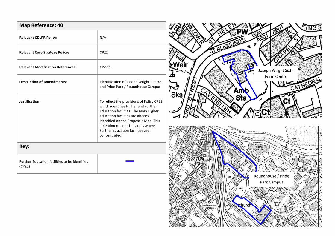
Map Reference: 40
Relevant CDLPR Policy:
N/A
Relevant Core Strategy Policy:
CP22
Relevant Modification References:
CP22.1
Description of Amendments:
Identification of Joseph Wright Centre and Pride Park / Roundhouse Campus
Justification:
To reflect the provisions of Policy CP22 which identifies Higher and Further Education facilities. The main Higher Education facilities are already identified on the Proposals Map. This amendment adds the areas where Further Education facilities are concentrated.
Key:
Further Education facilities to be identified (CP22)
Joseph Wright Sixth
Form Centre
Roundhouse / Pride
Park Campus

* The area shown is not an indication of specific land requirements. The extent of works and associated land requirements will be identified and safeguarded through the Local Plan Part 2.
Map Reference: 41
Relevant CDLPR Policy:
N/A
Relevant Core Strategy Policy:
CP24
Relevant Modification References:
CP24.1
Description of Amendments:
Identification of broad location of works to A52 / Wyvern junction
Justification:
To reflect strategic highways projects set out in Policy CP24
Key:
Broad location of A52 junction works to be identified*(CP24)

Map Reference: 42
Relevant CDLPR Policy:
N/A
Relevant Core Strategy Policy:
CP11, AC2
Relevant Modification References:
CP11.1
Description of Amendments:
Identification of Central Business District (CBD)
Justification:
To reflect provisions of Policy CP11 which seeks to direct new office development into the CBD
Key:
Extent of Central Business District to be identified (CP11)
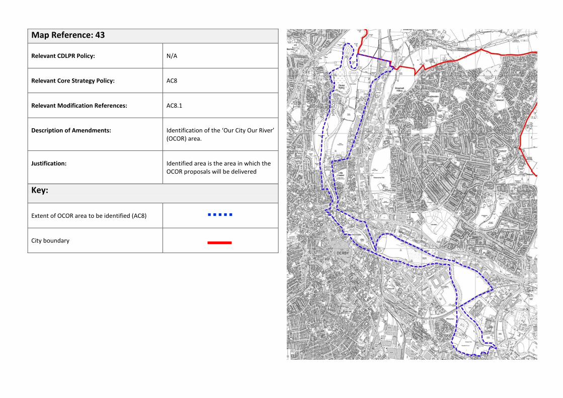
Map Reference: 43
Relevant CDLPR Policy:
N/A
Relevant Core Strategy Policy:
AC8
Relevant Modification References:
AC8.1
Description of Amendments:
Identification of the ‘Our City Our River’ (OCOR) area.
Justification:
Identified area is the area in which the OCOR proposals will be delivered
Key:
Extent of OCOR area to be identified (AC8)
City boundary

Map Reference: 44
Relevant CDLPR Policy:
N/A
Relevant Core Strategy Policy:
AC18
Relevant Modification References:
AC18.1
Description of Amendments:
Area to be identified for residential development
Justification:
Site identified as part of larger cross boundary housing site in the Local Plan Part 1
Key:
Area to be identified for residential development (AC18)
City boundary

Map Reference: 45
Relevant CDLPR Policy:
N/A
Relevant Core Strategy Policy:
AC24
Relevant Modification References:
AC24.2
Description of Amendments:
Area to be identified for residential development
Justification:
Site identified as part of larger cross boundary housing site in the Local Plan Part 1
Key:
Area to be identified for residential development (AC24)
City boundary

Appendix: Policy Matrix

CDLPR Policy Policy Text
Status
Replacement Policy
Number
Proposals Map
Allocation Status
Map Ref.
Proposal Map Amendment References
GD1 Social Inclusion REPLACED CP3 - - -
GD2 Protection of the Environment
REPLACED CP2, CP3, CP4 and CP16
- - -
GD3 Flood Protection REPLACED CP2 - - -
GD4 Design and the Urban Environment
REPLACED CP2 and CP3 - - -
GD5 Amenity SAVED - - - -
GD6 Safeguarding Development Potential
REPLACED Various - - -
GD7 Comprehensive Development
REPLACED MH1 - - -
GD8 Infrastructure REPLACED MH1 - - -
GD9 Implementation REPLACED MH1 - - -
R1 Regeneration Priorities
REPLACED CP5 REPLACED 1 R1.1 - Deletion: Orange stars removed from sites R2, R3, R4, R5, R6, R7 R8, EP1, EP2, EP3, EP5, EP6, EP7, LE6 CC4, CC5, CC6, CC8, CC9, CC12 and CC13 CP5.1 - Addition: New symbol on Derwent Estate, Rosehill and Peartree areas

R2 Friar Gate Station and Environs
PARTIALLY REPLACED / SAVED
AC2 SAVED
- -
R3 Land to the south of Slack Lane
SAVED - - - -
R4 Land at the former Manor and Kingsway Hospitals
REPLACED AC19 REPLACED 2 R4.1 – Deletion: Existing site boundary deleted AC19.1 – Addition: New revised boundary added
R5 Baseball Ground DELETED - DELETED 3 R5.1 - Deletion: Whole allocation to be deleted
R6 Darley Abbey Mills REPLACED AC10 REPLACED 4 R6.1 – Deletion: Existing site boundary to be deleted AC10.1 – Addition: New revised boundary added
R7 Markeaton Brook Mixed Use Area
DELETED - DELETED 5 R7.1 Deletion: Whole allocation to be deleted
R8 Normanton Road / Peartree Road Linear Centre
REPLACED CP12 SAVED - -
CC1
City Centre Strategy REPLACED AC1 / AC2 - - -
CC2
City Centre Shopping Area
REPLACED AC2 / AC3 REPLACED 6 CC2.1 – Deletion: CCSA deleted AC2.1 – Addition: Core Area added
CC3 Primary Frontages REPLACED AC3 REPLACED 7 CC3.1 – Deletion: Existing frontages deleted AC3.1 – Addition: New frontages added
CC4 Becketwell SAVED - SAVED - -

CC6 Bus Station SAVED - SAVED - -
CC7 Residential Uses within City Centre
REPLACED AC1 / AC2 - - -
CC8 Riverside – Derwent Street
REPLACED AC2 REPLACED 8 CC8.1 – Deletion: Whole allocation to be deleted AC2.2 – Addition: New ‘Quarters’ / character areas added – Cathedral, St Peters, Intu, Riverside and Fringes
CC9 Northern Quarter Policy Area
REPLACED AC2 REPLACED 8 CC9.1 – Deletion: Whole allocation to be deleted AC2.2 – Addition: New ‘Quarters’ / character areas added – Cathedral, St Peters, Intu, Riverside and Fringes
CC10 East Street / Morledge SAVED AC2 REPLACED 8 CC10.1 – Deletion: Whole allocation to be deleted AC2.2 – Addition: New ‘Quarters’ / character areas added – Cathedral, St Peters, Intu, Riverside and Fringes
CC11 Sadler Gate / Strand Arcade Special Shopping Area
REPLACED AC2 / AC3 REPLACED 8 CC11.1 – Deletion: Whole allocation to be deleted AC2.2 – Addition: New ‘Quarters’ / character areas added – Cathedral, St Peters, Intu, Riverside and Fringes
CC12 Full Street Police Station
SAVED - SAVED - -
CC13 Castleward REPLACED AC2 / AC6 REPLACED 9 CC13.1 – Deletion: Whole allocation to be deleted AC6.1 – Addition: New Castleward area added
CC14 Wellington Street REPLACED AC2 / AC6 REPLACED 9 CC14.1 – Deletion: Whole allocation to be deleted AC6.1 – Addition: New Castleward area added
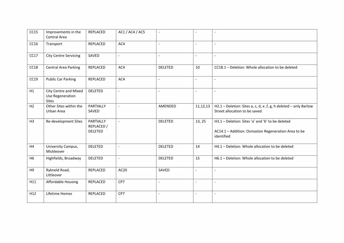
CC15 Improvements in the Central Area
REPLACED AC1 / AC4 / AC5 - - -
CC16 Transport REPLACED AC4 - - -
CC17 City Centre Servicing SAVED - - - -
CC18 Central Area Parking REPLACED AC4 DELETED 10 CC18.1 – Deletion: Whole allocation to be deleted
CC19 Public Car Parking REPLACED AC4 - - -
H1 City Centre and Mixed Use Regeneration Sites
DELETED - - - -
H2 Other Sites within the Urban Area
PARTIALLY SAVED
- AMENDED 11,12,13 H2.1 – Deletion: Sites a, c, d, e ,f, g, h deleted – only Barlow Street allocation to be saved
H3 Re-development Sites PARTIALLY REPLACED / DELETED
- DELETED 13, 25 H3.1 – Deletion: Sites ‘a’ and ‘b’ to be deleted AC14.1 – Addition: Osmaston Regeneration Area to be identified
H4 University Campus, Mickleover
DELETED - DELETED 14 H4.1 – Deletion: Whole allocation to be deleted
H6 Highfields, Broadway DELETED - DELETED 15 H6.1 – Deletion: Whole allocation to be deleted
H9 Rykneld Road, Littleover
REPLACED AC20 SAVED - -
H11 Affordable Housing REPLACED CP7 - - -
H12 Lifetime Homes REPLACED CP7 - - -
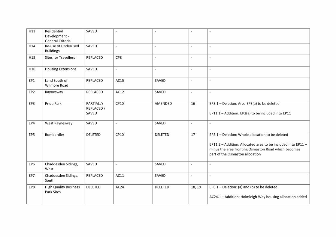
H13 Residential Development -General Criteria
SAVED - - - -
H14 Re-use of Underused Buildings
SAVED - - - -
H15 Sites for Travellers REPLACED CP8 - - -
H16 Housing Extensions SAVED - - - -
EP1 Land South of Wilmore Road
REPLACED AC15 SAVED - -
EP2 Raynesway REPLACED AC12 SAVED - -
EP3 Pride Park PARTIALLY REPLACED / SAVED
CP10 AMENDED 16 EP3.1 – Deletion: Area EP3(a) to be deleted EP11.1 – Addition: EP3(a) to be included into EP11
EP4 West Raynesway SAVED - SAVED - -
EP5 Bombardier DELETED CP10 DELETED 17 EP5.1 – Deletion: Whole allocation to be deleted EP11.2 – Addition: Allocated area to be included into EP11 – minus the area fronting Osmaston Road which becomes part of the Osmaston allocation
EP6 Chaddesden Sidings, West
SAVED - SAVED - -
EP7 Chaddesden Sidings, South
REPLACED AC11 SAVED - -
EP8 High Quality Business Park Sites
DELETED AC24 DELETED 18, 19 EP8.1 – Deletion: (a) and (b) to be deleted AC24.1 – Addition: Holmleigh Way housing allocation added
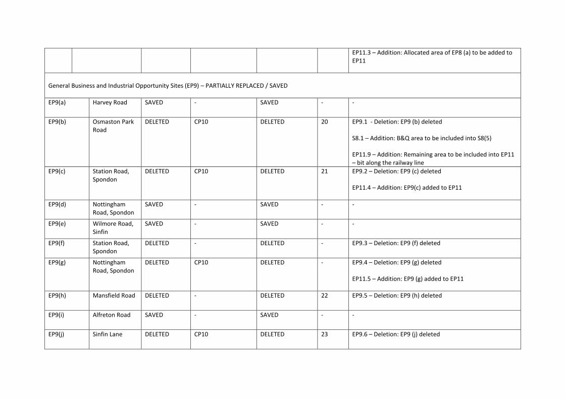
EP11.3 – Addition: Allocated area of EP8 (a) to be added to EP11
General Business and Industrial Opportunity Sites (EP9) – PARTIALLY REPLACED / SAVED
EP9(a) Harvey Road SAVED - SAVED - -
EP9(b) Osmaston Park Road
DELETED CP10 DELETED 20 EP9.1 - Deletion: EP9 (b) deleted S8.1 – Addition: B&Q area to be included into S8(5) EP11.9 – Addition: Remaining area to be included into EP11 – bit along the railway line
EP9(c) Station Road, Spondon
DELETED CP10 DELETED 21 EP9.2 – Deletion: EP9 (c) deleted EP11.4 – Addition: EP9(c) added to EP11
EP9(d) Nottingham Road, Spondon
SAVED - SAVED - -
EP9(e) Wilmore Road, Sinfin
SAVED - SAVED - -
EP9(f) Station Road, Spondon
DELETED - DELETED - EP9.3 – Deletion: EP9 (f) deleted
EP9(g) Nottingham Road, Spondon
DELETED CP10 DELETED - EP9.4 – Deletion: EP9 (g) deleted EP11.5 – Addition: EP9 (g) added to EP11
EP9(h) Mansfield Road DELETED - DELETED 22 EP9.5 – Deletion: EP9 (h) deleted
EP9(i) Alfreton Road SAVED - SAVED - -
EP9(j) Sinfin Lane DELETED CP10 DELETED 23 EP9.6 – Deletion: EP9 (j) deleted

EP11.6 – Addition: EP9 (j) added to EP11
EP10 Major Office Development
REPLACED CP11 - - -
EP11 Development in Existing Business and Industrial Areas
REPLACED CP10 AMENDED 20, 24, 25, 26, 27
EP11.7 – Deletion: Sinfin Lane housing allocation removed from EP11 AC17.1 – Addition: Sinfin Lane housing allocation added EP11.8 – Deletion: Nightingale Road Works and other areas of employment land within the triangle to be removed. Ribbon of EP11 area to the east of Osmaston Road to be removed EP11.10 – Deletion: Celanese to be deleted from EP11 AC13.1 – Addition: Celanese site to be added as a regeneration area EP11.11 – Deletion: RR Campus area to be deleted from EP11 AC16.1 – Addition: RR Campus area to be added as a regeneration area EP11.12 - Deletion: Area of existing employment land off Peak Drive to be deleted. S8.2 – Addition: Existing employment land to be included into S8(5)
EP12 Alternative Uses of Proposed Business and
REPLACED AC11, AC12, AC15 - - -

Industrial Areas
EP13 Business and Industrial Development in Other Areas
REPLACED CP10 - - -
EP14 Employment with Potential Off-Site Effects
DELETED - - - -
EP15 Visitor Attractions
REPLACED CP15 - - -
EP16 Visitor Accommodation
REPLACED CP15 - - -
S1 Shopping Hierarchy
REPLACED CP12 - - -
S2 Retail Location Criteria
REPLACED CP12 - - -
S3 District and Neighbourhood Centres
REPLACED CP12 SAVED - -
S4 Proposed Neighbourhood Centres
REPLACED CP12 DELETED 28 S4.1 – Deletion: West Chellaston Neighbourhood Centre to be removed CP12.1 – Addition: West Chellaston Neighbourhood Centre to be added
S5 Small Shops REPLACED CP13 - - -
S6 Extensions to Small Shops
REPLACED CP13 - - -
S7 Conversion of Shops
REPLACED CP13 - - -
S8 Out-of-Centre Retail Parks and
REPLACED CP13 SAVED - -

Other Locations
S9 Range of Goods and Alterations to Retail Units
REPLACED CP13 - - -
S10 Trade and Showroom Type Sales
SAVED - - - -
S11 Factory Shops SAVED - - - -
S12 Financial and Professional Services and Food and Drink Uses
REPLACED CP14 - - -
E1 Green Belt REPLACED CP16 SAVED - -
E2 Green Wedges REPLACED CP18 AMENDED 29, 30, 31, 32
E2.1 – Deletion: Eastern extent of Hackwood Farm allocation removed from Green Wedge AC21.1 – Addition: Hackwood Farm housing allocation added E2.2 – Deletion: Onslow Road allocation removed from Green Wedge AC22.1 – Addition: Onslow Road housing allocation added E2.3 – Deletion: Mackworth College allocation removed from Green Wedge AC22.2 – Addition: Mackworth College housing allocation added E2.4 – Deletion: Boulton Moor (800) allocation removed

from Green Wedge AC23.1 – Addition: Boulton Moor housing allocation added E2.5 – Deletion: Fellowlands Way allocation removed from Green Wedge AC23.1 – Addition: Fellowlands Way housing allocation added E2.6 - Deletion: Brook Farm allocation removed from Green Wedge AC25.1 – Addition: Brook Farm housing allocation added E2.7 – Deletion: Lime Lane site removed from Green Wedge AC26.1 – Addition: Lime Lane housing allocation added
E4 Nature Conservation
REPLACED CP16 and CP19 AMENDED 29 E4.1 – Deletion: Onslow Road wildlife site (E4(76)) removed
E5 Biodiversity REPLACED CP16 and CP19 - - -
E6 Wildlife Corridors
REPLACED CP16 and CP19 SAVED - -
E7 Protection of Habitats
REPLACED CP16 and CP19 - - -
E8 Enhancing the Natural Environment
REPLACED CP16 and CP19 - - -
E9 Trees REPLACED CP16 and CP19 - - -
E10 Renewable Energy
REPLACED CP2 - - -

E11 Recycling Facilities
SAVED - - - -
E12 Pollution SAVED - - - -
E13 Contaminated Land
SAVED - - - -
E14 Development in Proximity to existing Operations
SAVED - - - -
E15 Protection of Mineral Resources
SAVED - - - -
E16 Development close to important open land
REPLACED CP3 - - -
E17 Landscaping Schemes
SAVED - - - -
E18 Conservation Areas
PARTIALLY REPLACED / SAVED
CP20 AMENDED 33, 34, 35, 36
E18.1 – Amendments: Various changes to existing Conservation Area boundaries E18.2 – Addition: Green Lane Conservation Area to be added
E19 Listed Buildings and Buildings of Local Importance
PARTIALLY REPLACED / SAVED
CP20 - - -
E20 Uses within Buildings of Architectural or Historical Importance
PARTIALLY REPLACED / SAVED
CP20 - - -

E21 Archaeology PARTIALLY REPLACED / SAVED
CP20 SAVED - -
E22 Historic Parks and Gardens
PARTIALLY REPLACED / SAVED
CP20 SAVED - -
E23 Design REPLACED CP3, CP4 - - -
E24 Community Safety
SAVED - - - -
E25 Building Security Measures
SAVED - - - -
E26 Advertisements SAVED - - - -
E27 Environmental Art
REPLACED CP3 - - -
E29 World Heritage Site and its Surroundings
REPLACED CP20, AC9 SAVED - -
E30 Safeguarded Areas Around Aerodromes
SAVED - SAVED - -
L1 Protection of Parks and Public Open Space
REPLACED CP17 SAVED - -
L2 Public Open Space Standards
REPLACED CP17 - - -
L3 Public Open Space Requirements in New Development
REPLACED CP17 - - -
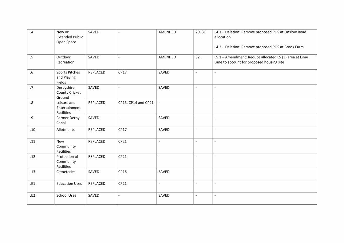
L4 New or Extended Public Open Space
SAVED - AMENDED 29, 31 L4.1 – Deletion: Remove proposed POS at Onslow Road allocation L4.2 – Deletion: Remove proposed POS at Brook Farm
L5 Outdoor Recreation
SAVED - AMENDED 32 L5.1 – Amendment: Reduce allocated L5 (3) area at Lime Lane to account for proposed housing site
L6 Sports Pitches and Playing Fields
REPLACED CP17 SAVED - -
L7 Derbyshire County Cricket Ground
SAVED - SAVED - -
L8 Leisure and Entertainment Facilities
REPLACED CP13, CP14 and CP21 - - -
L9 Former Derby Canal
SAVED - SAVED - -
L10 Allotments REPLACED CP17 SAVED - -
L11 New Community Facilities
REPLACED CP21 - - -
L12 Protection of Community Facilities
REPLACED CP21 - - -
L13 Cemeteries SAVED CP16 SAVED - -
LE1 Education Uses REPLACED CP21 - - -
LE2 School Uses SAVED - SAVED - -

LE3 University District
REPLACED CP22 SAVED - -
LE4 Derby University Main Campus
REPLACED CP22 SAVED - -
LE5 Derby College Campus, Wilmorton
DELETED - DELETED 37 LE5.1 – Deletion: Whole allocation to be deleted
LE6 Derbyshire Royal Infirmary
REPLACED AC6 REPLACED 38 LE6.1 – Deletion: Whole allocation to be deleted AC6.2 – Addition: New boundary of DRI to be added
T1 Transport Implications of New Development
REPLACED - - - -
T2 City Council Schemes
SAVED - SAVED - -
T3 Highways Agency Schemes
REPLACED CP24 SAVED - -
T4 Access, Parking and Servicing
REPLACED CP23 - - -
T5 Off-Street Parking
REPLACED CP23 - - -
T6 Provision for Pedestrians
REPLACED CP23 - - -
T7 Provision for Cyclists
REPLACED CP23 - - -
T8 Provision for Public Transport
REPLACED CP23 - - -
T9 Park and Ride SAVED - SAVED - -
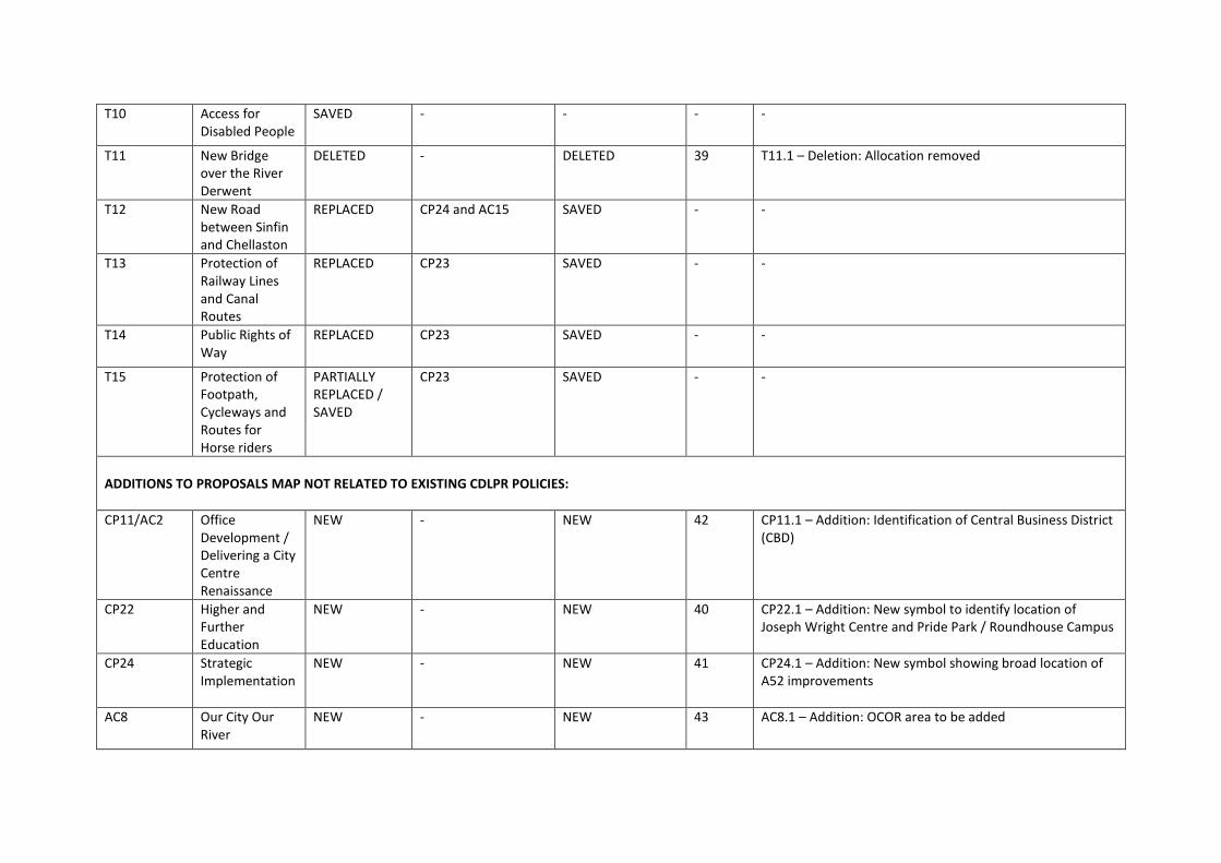
T10 Access for Disabled People
SAVED - - - -
T11 New Bridge over the River Derwent
DELETED - DELETED 39 T11.1 – Deletion: Allocation removed
T12 New Road between Sinfin and Chellaston
REPLACED CP24 and AC15 SAVED - -
T13 Protection of Railway Lines and Canal Routes
REPLACED CP23 SAVED - -
T14 Public Rights of Way
REPLACED CP23 SAVED - -
T15 Protection of Footpath, Cycleways and Routes for Horse riders
PARTIALLY REPLACED / SAVED
CP23 SAVED - -
ADDITIONS TO PROPOSALS MAP NOT RELATED TO EXISTING CDLPR POLICIES:
CP11/AC2 Office Development / Delivering a City Centre Renaissance
NEW - NEW 42 CP11.1 – Addition: Identification of Central Business District (CBD)
CP22 Higher and Further Education
NEW - NEW 40 CP22.1 – Addition: New symbol to identify location of Joseph Wright Centre and Pride Park / Roundhouse Campus
CP24 Strategic Implementation
NEW - NEW 41 CP24.1 – Addition: New symbol showing broad location of A52 improvements
AC8 Our City Our River
NEW - NEW 43 AC8.1 – Addition: OCOR area to be added

AC18 Wragley Way NEW - NEW 44 AC18.1 – Addition: Wragley Way site to be added
AC24 South of Chellaston
NEW - NEW 45 AC24.2 – Addition: Woodlands Farm site to be added