Embed Size (px)
DESCRIPTION
LRO SRR. LRO Mission Overview. 2008 Lunar Reconnaissance Orbiter (LRO) First Step in the Robotic Lunar Exploration Program. LRO Objectives - PowerPoint PPT Presentation
Citation preview
03 - 1NASA’s Goddard Space Flight Center
LRO SRR
LRO Mission Overview
03 - 2NASA’s Goddard Space Flight Center
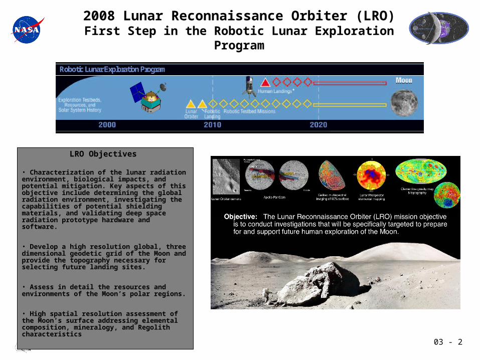
2008 Lunar Reconnaissance Orbiter (LRO)First Step in the Robotic Lunar Exploration
Program
Robotic Lunar Exploration ProgramRobotic Lunar Exploration Program
LRO Objectives
• Characterization of the lunar radiation environment, biological impacts, and potential mitigation. Key aspects of this objective include determining the global radiation environment, investigating the capabilities of potential shielding materials, and validating deep space radiation prototype hardware and software.
• Develop a high resolution global, three dimensional geodetic grid of the Moon and provide the topography necessary for selecting future landing sites.
• Assess in detail the resources and environments of the Moon’s polar regions.
• High spatial resolution assessment of the Moon’s surface addressing elemental composition, mineralogy, and Regolith characteristics
03 - 3NASA’s Goddard Space Flight Center
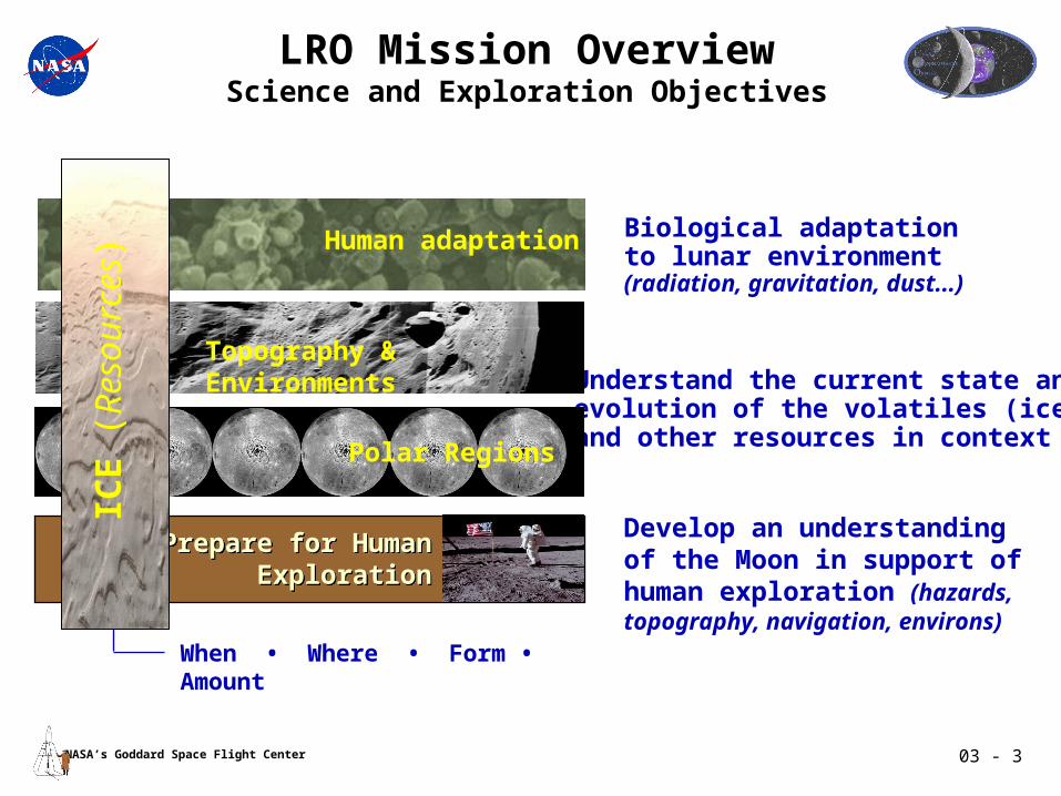
Develop an understanding of the Moon in support of human exploration (hazards, topography, navigation, environs)
Understand the current state and evolution of the volatiles (ice) and other resources in context
Biological adaptation to lunar environment (radiation, gravitation, dust...)
GEOLOGYGEOLOGY
EnvironsEnvirons
Prepare for Human Exploration
Prepare for Human Exploration
When • Where • Form • Amount
Topography & Environments
Polar Regions
Human adaptation
ICE
(R
esou
rces
)
LRO Mission OverviewScience and Exploration Objectives
03 - 4NASA’s Goddard Space Flight Center
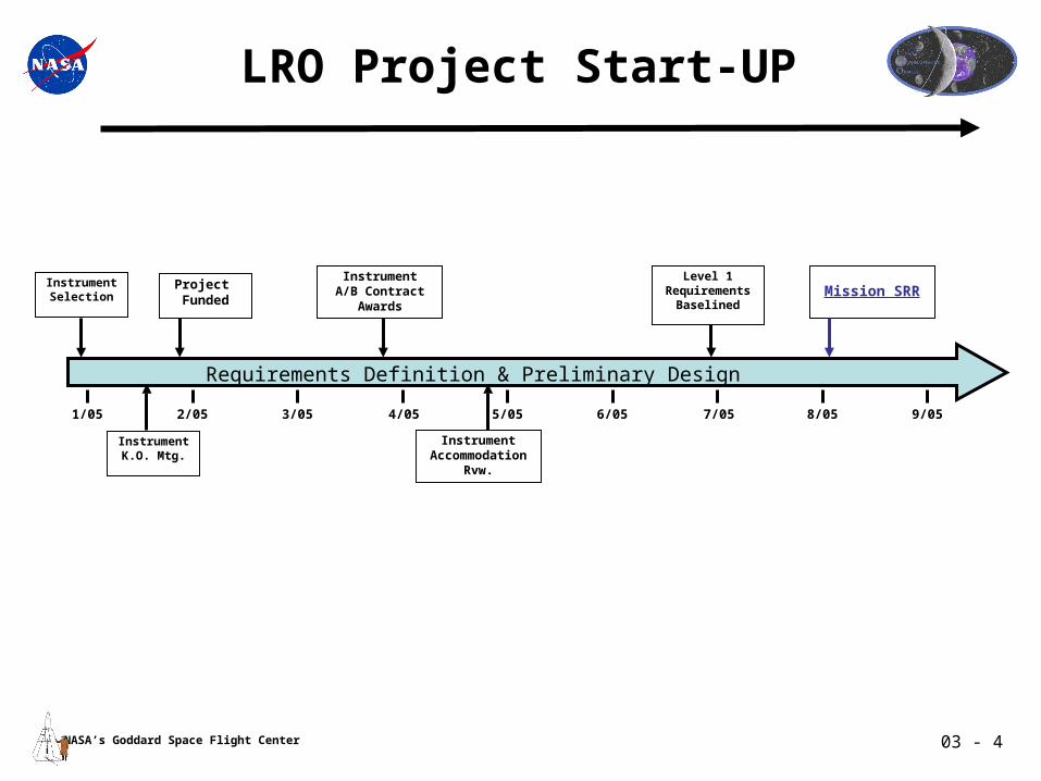
LRO Project Start-UP
Instrument Selection
Project Funded
InstrumentK.O. Mtg.
1/05 2/05 3/05 4/05 5/05 7/056/05 8/05 9/05
InstrumentAccommodation
Rvw.
InstrumentA/B Contract
AwardsMission SRR
Requirements Definition & Preliminary Design
Level 1Requirements
Baselined

03 - 5NASA’s Goddard Space Flight Center
• Launch on a Delta II rocket into a direct insertion trajectory to the moon.
• On-board propulsion system used to capture at the moon, insert into and maintain 50 km altitude circular polar reconnaissance orbit.
• 1 year mission• Orbiter is a 3-axis stabilized,
nadir pointed spacecraft designed to operate continuously during the primary mission.
LRO Mission OverviewFlight Plan – Direct using 3-Stage ELV
Solar Rotating Coordinates
Earth
Moon at encounter
Cis-lunar transfer5.1978 day transferLaunch C3 –2.07 km2/s2
1-dayLunar Orbit
Sun direction
Nominal Cis-lunar Trajectory
Cis-Lunar Transfer
12-hour orbit
6-hour orbit
100 and 50kmmission orbits
Insertion and CircularizationImpulsive Vs (m/s)
1 – 344.242 – 113.063 – 383.914 – 11.455 – 12.18
03 - 6NASA’s Goddard Space Flight Center
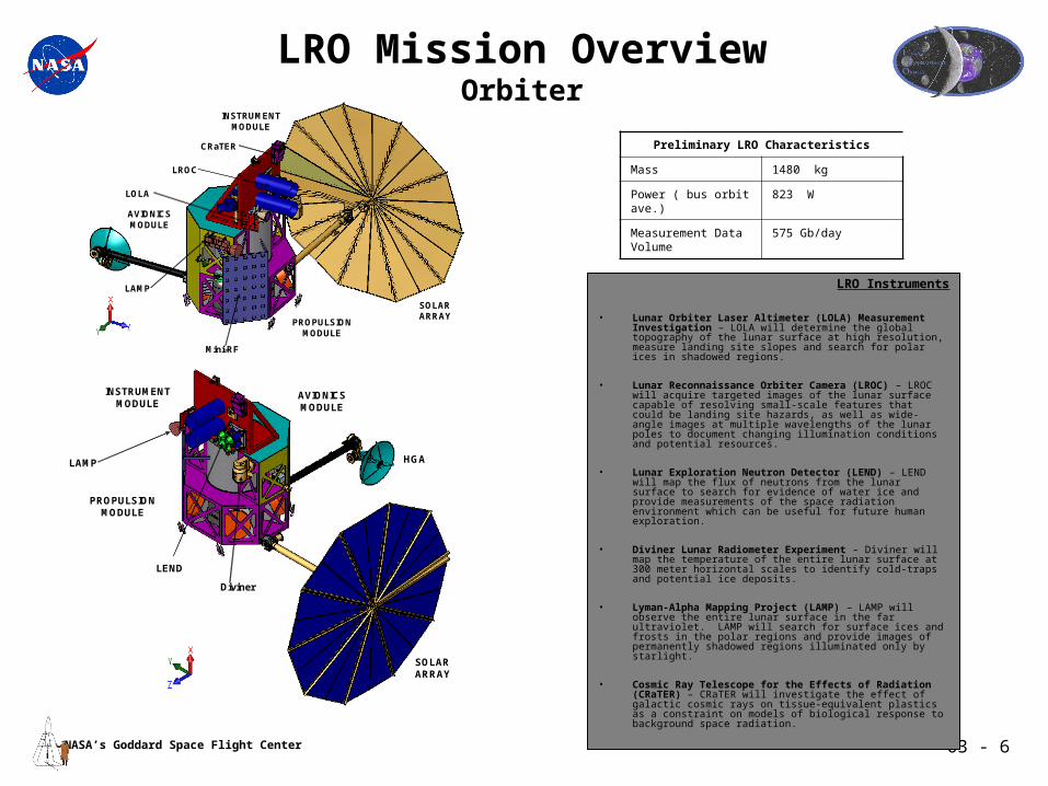
LRO Mission OverviewOrbiter
Preliminary LRO Characteristics
Mass 1480 kg
Power ( bus orbit ave.) 823 W
Measurement Data Volume
575 Gb/day
LRO Instruments
• Lunar Orbiter Laser Altimeter (LOLA) Measurement Investigation – LOLA will determine the global topography of the lunar surface at high resolution, measure landing site slopes and search for polar ices in shadowed regions.
• Lunar Reconnaissance Orbiter Camera (LROC) – LROC will acquire targeted images of the lunar surface capable of resolving small-scale features that could be landing site hazards, as well as wide-angle images at multiple wavelengths of the lunar poles to document changing illumination conditions and potential resources.
• Lunar Exploration Neutron Detector (LEND) – LEND will map the flux of neutrons from the lunar surface to search for evidence of water ice and provide measurements of the space radiation environment which can be useful for future human exploration.
• Diviner Lunar Radiometer Experiment – Diviner will map the temperature of the entire lunar surface at 300 meter horizontal scales to identify cold-traps and potential ice deposits.
• Lyman-Alpha Mapping Project (LAMP) – LAMP will observe the entire lunar surface in the far ultraviolet. LAMP will search for surface ices and frosts in the polar regions and provide images of permanently shadowed regions illuminated only by starlight.
• Cosmic Ray Telescope for the Effects of Radiation (CRaTER) – CRaTER will investigate the effect of galactic cosmic rays on tissue-equivalent plastics as a constraint on models of biological response to background space radiation.
SOLAR ARRAY
PROPULSION MODULE
AVIONICS MODULE
INSTRUMENT MODULE
Mini-RF
LOLA
LAMP
LROC
CRaTER
SOLAR ARRAY
HGA
PROPULSION MODULE
AVIONICS MODULE
INSTRUMENT MODULE
Diviner
LEND
LAMP
03 - 7NASA’s Goddard Space Flight Center
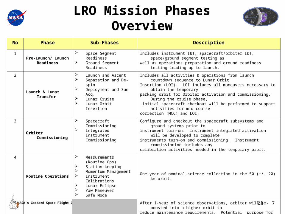
LRO Mission Phases Overview
No Phase Sub-Phases Description
1Pre-Launch/ Launch
Readiness
Space Segment Readiness Ground Segment Readiness
Includes instrument I&T, spacecraft/orbiter I&T, space/ground segment testing as well as operations preparation and ground readiness testing leading up to launch.
2
Launch & Lunar Transfer
Launch and Ascent Separation and De-spin Deployment and Sun Acq. Lunar Cruise Lunar Orbit Insertion
Includes all activities & operations from launch countdown sequence to Lunar Orbit Insertion (LOI). LOI includes all maneuvers necessary to obtain the temporary parking orbit for Orbiter activation and commissioning. During the cruise phase, initial spacecraft checkout will be performed to support activities for mid course correction (MCC) and LOI.
3
Orbiter Commissioning
Spacecraft Commissioning Integrated Instrument
Commissioning
Configure and checkout the spacecraft subsystems and ground systems prior to instrument turn-on. Instrument integrated activation will be developed to complete instruments turn-on and commissioning. Instrument commissioning includes any calibration activities needed in the temporary orbit.
4
Routine Operations
Measurements (Routine Ops) Station-keeping Momentum Management Instrument Calibrations Lunar Eclipse Yaw Maneuver Safe Mode
One year of nominal science collection in the 50 (+/- 20) km orbit.
5Extended Mission
Operations
After 1-year of science observations, orbiter will be boosted into a higher orbit to reduce maintenance requirements. Potential purpose for extended mission operationsmay be to perform relay comm. operations. Alternatively additional measurementoperations may be performed for a shorter period in a continued low orbit.
6End-of-Mission Disposal
Includes planning and execution of end-of-life operations. LRO will impact lunar surface.
03 - 8NASA’s Goddard Space Flight Center
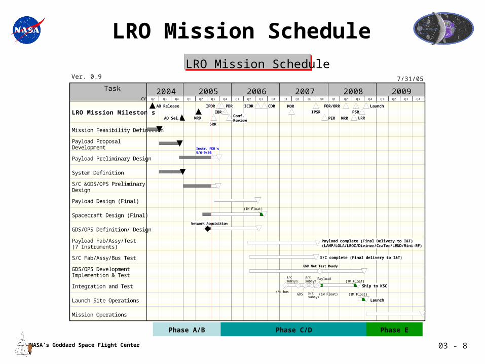
LRO Mission Schedule
2004 2005 2006 2007 2008 2009Q2 Q3 Q4 Q1 Q2 Q3 Q4 Q1 Q2 Q3 Q4 Q1 Q2 Q3 Q4 Q1 Q2 Q3 Q4 Q1 Q2 Q3 Q4
7/31/05
LRO Mission Schedule
Task
LRO Mission Milestones
Mission Feasibility Definition
Payload Proposal Development
Payload Preliminary Design
System Definition
S/C &GDS/OPS Preliminary Design
Payload Design (Final)
Spacecraft Design (Final)
GDS/OPS Definition/ Design
Payload Fab/Assy/Test(7 Instruments)
S/C Fab/Assy/Bus Test
GDS/OPS DevelopmentImplemention & Test
Integration and Test
Launch Site Operations
Mission Operations
AO Release
AO Sel. MRD
SRR
IPDR PDR
IBRConf. Review
ICDR CDR MOR
IPSR
PER
FOR/ORR
MRR
PSR
LRR
Launch
Instr. PDR's9/6-9/30
Network Acquisition
Payload complete (Final Delivery to I&T)(LAMP/LOLA/LROC/Diviner/CraTer/LEND/Mini-RF)
S/C complete (Final delivery to I&T)
GND Net Test Ready
Ship to KSC
Launch
(1M Float)
s/c bus
s/c subsys
GDS
s/c subsys
s/csubsys
Payload(1M Float)
(1M Float)
Ver. 0.9
(1M Float)
CY
Phase A/B Phase C/D Phase E
03 - 9NASA’s Goddard Space Flight Center
LRO SRR
LRO Science Overview
Dr. Gordon Chin

03 - 10NASA’s Goddard Space Flight Center
LRO Science Overview• LRO follows in the footsteps of the Lunar Orbiter missions
which proceeded Apollo.
• LRO will launch by 2008 to provide critically needed data to enable and to plan future Exploration objectives
• LRO provides major exploration and scientific benefits by 2009– Apollo provided first order information from a small
region of the Moon; much more of the Moon needs to be explored
– LRO objectives addresses future landing sites, polar resources, safety, and lunar science goals
– LRO address both science and exploration objectives
• LRO instrument suite complements international lunar missions– Six instruments competitively selected– Comparison to international missions demonstrate
LRO uniqueness and value
03 - 11NASA’s Goddard Space Flight Center
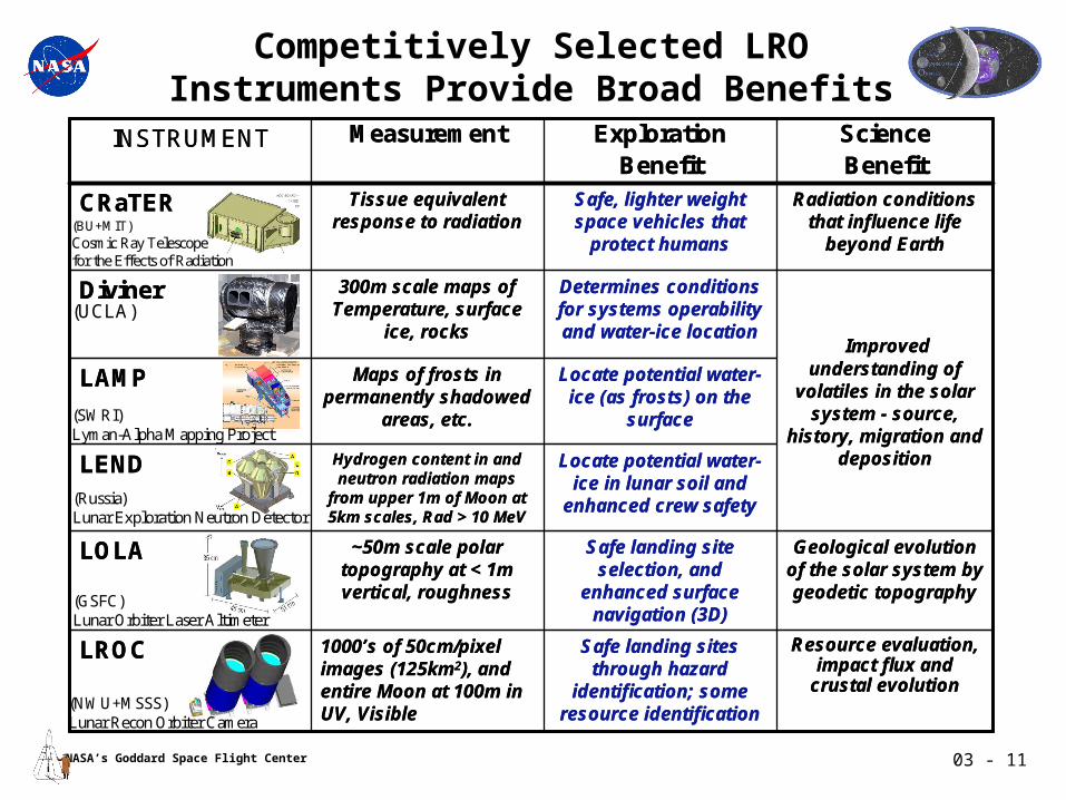
Competitively Selected LRO Instruments Provide Broad Benefits
1000’s of 50cm/pixel images (125km2), and entire Moon at 100m in UV, Visible
~50m scale polar topography at < 1m vertical, roughness
Hydrogen content in and neutron radiation maps
from upper 1m of Moon at 5km scales, Rad > 10 MeV
Maps of frosts in permanently shadowed
areas, etc.
300m scale maps of Temperature, surface
ice, rocks
Tissue equivalent response to radiation
Measurement
Resource evaluation, impact flux and
crustal evolution
Safe landing sitesthrough hazard
identification; some resource identification
LROC
Geological evolution of the solar system by geodetic topography
Safe landing site selection, and
enhanced surface navigation (3D)
LOLA
Improved understanding of
volatiles in the solar system - source,
history, migration and depositionLocate potential water-
ice in lunar soil and enhanced crew safety
LEND
Locate potential water-ice (as frosts) on the
surface
LAMP
Determines conditionsfor systems operability and water-ice location
Diviner
Radiation conditions that influence life
beyond Earth
Safe, lighter weight space vehicles that
protect humans
CRaTER
ScienceBenefit
ExplorationBenefit
INSTRUMENT
(BU+MIT)Cosmic Ray Telescopefor the Effects of Radiation
(UCLA)
(SWRI)Lyman-Alpha Mapping Project
(Russia)Lunar Exploration Neutron Detector
(GSFC)Lunar Orbiter Laser Altimeter
(NWU+MSSS)Lunar Recon Orbiter Camera
03 - 12NASA’s Goddard Space Flight Center
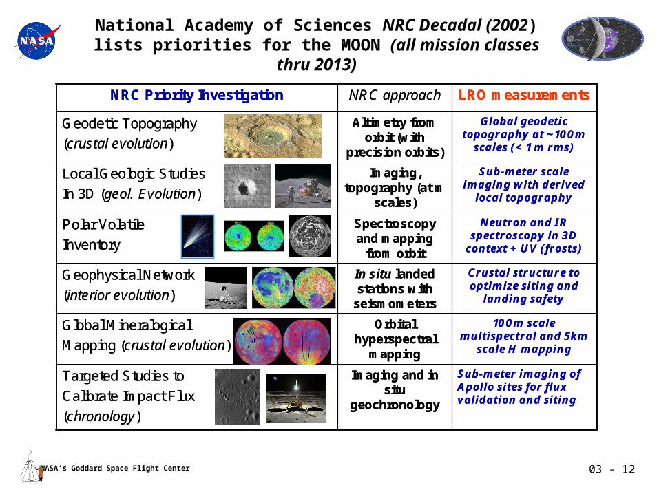
National Academy of Sciences NRC Decadal (2002) lists priorities for the MOON (all mission classes
thru 2013)
Sub-meter imaging of Apollo sites for flux validation and siting
Imaging and in situ
geochronology
Targeted Studies to
Calibrate Impact Flux
(chronology)
100m scale multispectral and 5km
scale H mapping
Orbital hyperspectral
mapping
Global Mineralogical
Mapping (crustal evolution)
Crustal structure to optimize siting and
landing safety
In situ landed stations with
seismometers
Geophysical Network
(interior evolution)
Neutron and IR spectroscopy in 3D
context + UV (frosts)
Spectroscopy and mapping
from orbit
Polar Volatile
Inventory
Sub-meter scale imaging with derived
local topography
Imaging, topography (at m
scales)
Local Geologic Studies
In 3D (geol. Evolution)
Global geodetic topography at ~100m
scales (< 1 m rms)
Altimetry from orbit (with
precision orbits)
Geodetic Topography
(crustal evolution)
LRO measurementsNRC approachNRC Priority Investigation

03 - 13NASA’s Goddard Space Flight Center
Comparison to International Systems Demonstrate Uniqueness and Value
Likely (contributed mineralogy mapping?)
Particles and Fields, etc.Particles and Fields, Farside gravity, elemental chemistry
Far UV imaging for frosts and lunar atmosphere (farside gravity from lidar)
OTHER
TBDLimitedPartially addressed, but frequency TBD?
High time-rate polar imaging (Imagers)
Polar illumination
Not addressed, but imaging (MS) will be included (10’s m/pixel)
Not addressed (best imaging is 10-100 m/pixel)
Not addressed: best imaging is ~10m/pixel stereo, MS imaging (10+ VISNIR bands)
Targeted, meter-scale feature detection, hazards (Imager, Lidar)
Sub-meter imaging for landing site assessment
TBD (contributed S-band SAR and Mineral mapping from US?)
Not addressedNot addressed in this mission (cf. GRS)
~25-400m scales in shadows (Imager, Lidar, NS, IR, UV)
Putative ice deposits at poles
TBDNot addressedNot addressedLandform scale at 3-5K (40-300K): ~300m scale
(IR mapper)
T mapping cold traps (polar)
Some potential, but depends on contributed sensors
Limited to 100’s of km scale (H) [does not meet LRO goals]
160km scale via GRS (does not meet LRO goals)
Landform scale at 100 ppm(~5 km scale at poles) (imaging NS)
H mapping to assess ice
Not addressedNot addressed1.6 km x, y at > 20 m vertical precision (RMS)
[not meet LRO goals]
10’s m x,y, with < 1m vertical precision, attn to poles (Lidar)
Geodetic topography (global)
Not addressedNot addressedNot addressedShielding expt’s with TEP (Rad Sensor)
Shielding materials
(test-beds)
Not addressedNot addressedNot addressedBiological responses to radiation (Rad Sensor)
Biological Adaptation
TBDLimited to some energy ranges
Highly limited overlap in some narrow energy ranges
Global assessment including neutrons, GCR (imaging NS, Rad Sensor)
Radiation Environment
Chandrayaan(ISRO 2007-2008 launch)
[100+ km orbit]
SMART-1 (ESA lunar 2005 orbiter)
[250km periapsis]
SELENE (JAXA orbiter ~ 2007)
[100km orbit, 1 yr]
2008 NASA LRO[50km orbit, 1 yr+]
Competed Payload
Reqt’s for LRO(from NASA ORDT, and ESMD RLEP Reqt’s 9/04; NRC Decadal, 2002)


![Lunar Reconnaissance Orbiter (LRO): Leading NASA’s Way ...2].pdf · Lunar Reconnaissance Orbiter (LRO): Leading NASA’s Way Back to the Moon ... nancy.n.jones@nasa.gov Jonas Dino](https://img.pdfslide.tips/doc/110x75/5e703682e07d8403d07255d8/lunar-reconnaissance-orbiter-lro-leading-nasaas-way-2pdf-lunar-reconnaissance.jpg)