Embed Size (px)
Citation preview
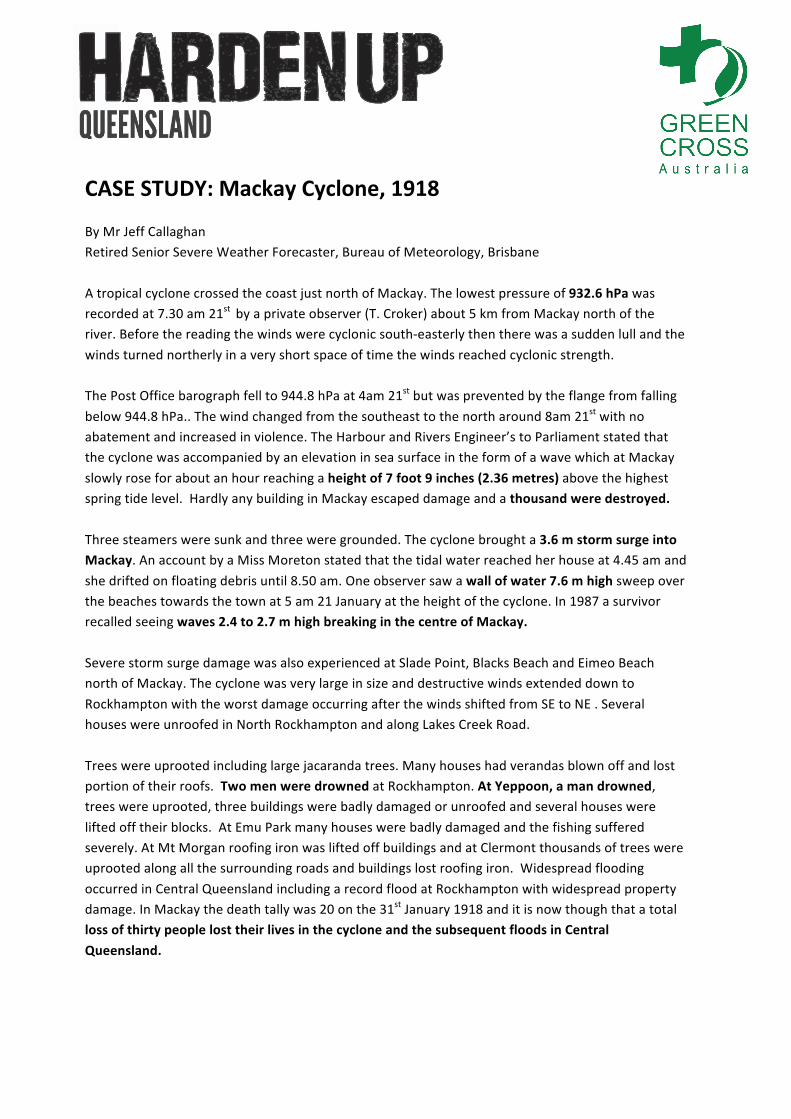
CASE STUDY: Mackay Cyclone, 1918 By Mr Jeff Callaghan Retired Senior Severe Weather Forecaster, Bureau of Meteorology, Brisbane A tropical cyclone crossed the coast just north of Mackay. The lowest pressure of 932.6 hPa was recorded at 7.30 am 21st by a private observer (T. Croker) about 5 km from Mackay north of the river. Before the reading the winds were cyclonic south-‐easterly then there was a sudden lull and the winds turned northerly in a very short space of time the winds reached cyclonic strength. The Post Office barograph fell to 944.8 hPa at 4am 21st but was prevented by the flange from falling below 944.8 hPa.. The wind changed from the southeast to the north around 8am 21st with no abatement and increased in violence. The Harbour and Rivers Engineer’s to Parliament stated that the cyclone was accompanied by an elevation in sea surface in the form of a wave which at Mackay slowly rose for about an hour reaching a height of 7 foot 9 inches (2.36 metres) above the highest spring tide level. Hardly any building in Mackay escaped damage and a thousand were destroyed. Three steamers were sunk and three were grounded. The cyclone brought a 3.6 m storm surge into Mackay. An account by a Miss Moreton stated that the tidal water reached her house at 4.45 am and she drifted on floating debris until 8.50 am. One observer saw a wall of water 7.6 m high sweep over the beaches towards the town at 5 am 21 January at the height of the cyclone. In 1987 a survivor recalled seeing waves 2.4 to 2.7 m high breaking in the centre of Mackay. Severe storm surge damage was also experienced at Slade Point, Blacks Beach and Eimeo Beach north of Mackay. The cyclone was very large in size and destructive winds extended down to Rockhampton with the worst damage occurring after the winds shifted from SE to NE . Several houses were unroofed in North Rockhampton and along Lakes Creek Road. Trees were uprooted including large jacaranda trees. Many houses had verandas blown off and lost portion of their roofs. Two men were drowned at Rockhampton. At Yeppoon, a man drowned, trees were uprooted, three buildings were badly damaged or unroofed and several houses were lifted off their blocks. At Emu Park many houses were badly damaged and the fishing suffered severely. At Mt Morgan roofing iron was lifted off buildings and at Clermont thousands of trees were uprooted along all the surrounding roads and buildings lost roofing iron. Widespread flooding occurred in Central Queensland including a record flood at Rockhampton with widespread property damage. In Mackay the death tally was 20 on the 31st January 1918 and it is now though that a total loss of thirty people lost their lives in the cyclone and the subsequent floods in Central Queensland.
Mackay Cyclone, 1918 Data by J. Callaghan 9 September 2011
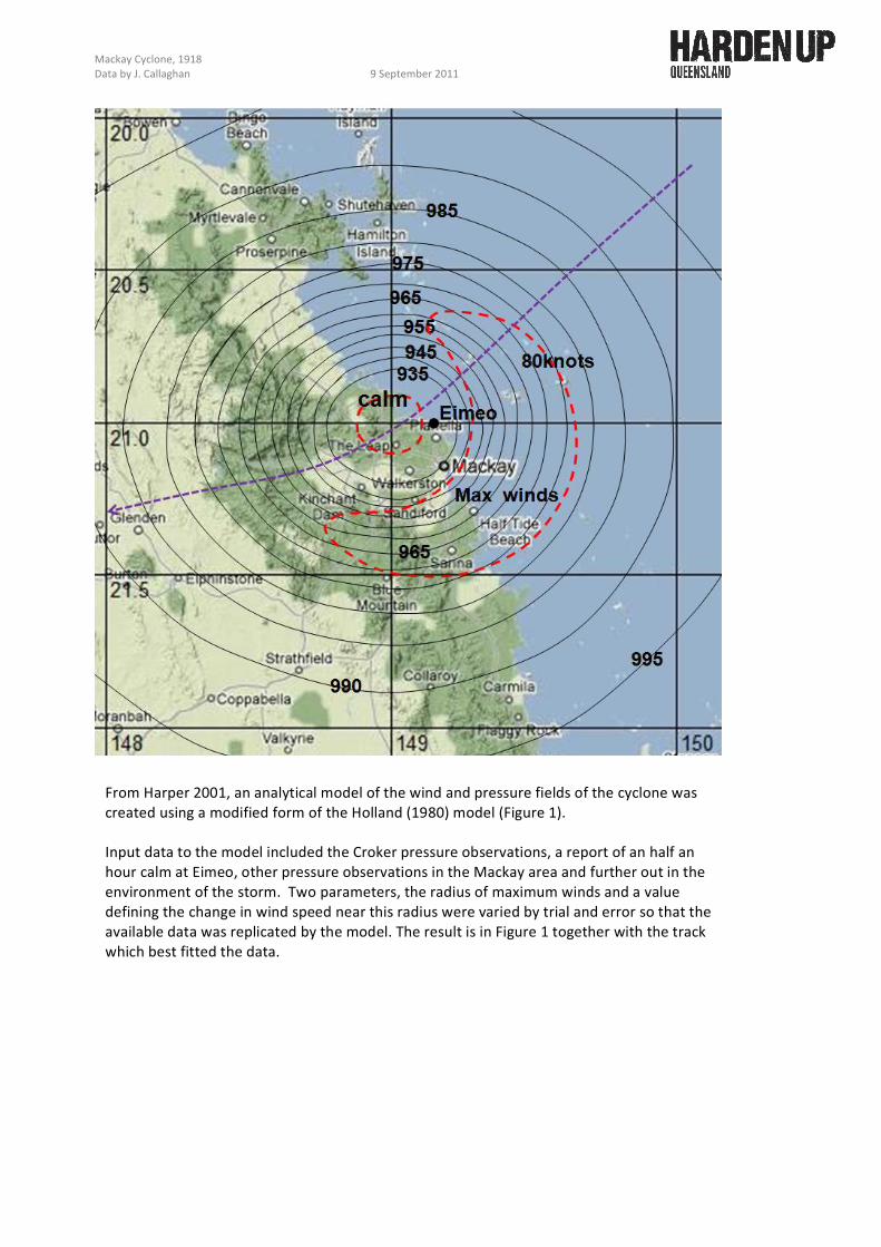
From Harper 2001, an analytical model of the wind and pressure fields of the cyclone was created using a modified form of the Holland (1980) model (Figure 1). Input data to the model included the Croker pressure observations, a report of an half an hour calm at Eimeo, other pressure observations in the Mackay area and further out in the environment of the storm. Two parameters, the radius of maximum winds and a value defining the change in wind speed near this radius were varied by trial and error so that the available data was replicated by the model. The result is in Figure 1 together with the track which best fitted the data.
Mackay Cyclone, 1918 Data by J. Callaghan 9 September 2011
1016
1012
1008
1004
1000
996
1020
2300 UTC 20 January 1918
• Rockhampton •
Clermont Emerald
•
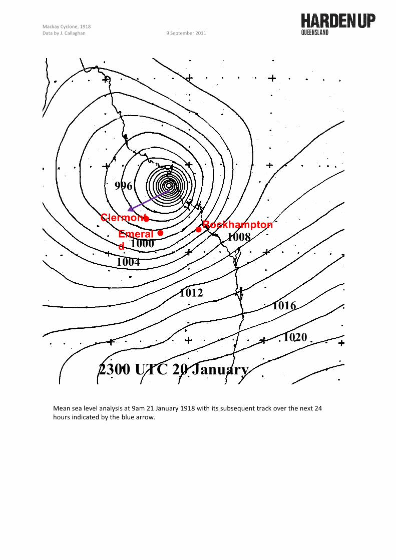
Mean sea level analysis at 9am 21 January 1918 with its subsequent track over the next 24 hours indicated by the blue arrow.
Mackay Cyclone, 1918 Data by J. Callaghan 9 September 2011
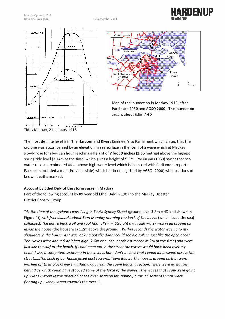
Tides Mackay, 21 January 1918 The most definite level is in The Harbour and Rivers Engineer’s to Parliament which stated that the cyclone was accompanied by an elevation in sea surface in the form of a wave which at Mackay slowly rose for about an hour reaching a height of 7 foot 9 inches (2.36 metres) above the highest spring tide level (3.14m at the time) which gives a height of 5.5m. Parkinson (1950) states that sea water rose approximated 8feet above high water level which is in accord with Parliament report. Parkinson included a map (Previous slide) which has been digitised by AGSO (2000) with locations of known deaths marked. Account by Ethel Daly of the storm surge in Mackay Part of the following account by 89 year old Ethel Daly in 1987 to the Mackay Disaster District Control Group: “At the time of the cyclone I was living in South Sydney Street (ground level 3.8m AHD and shown in Figure 4)) with friends……At about 6am Monday morning the back of the house (which faced the sea) collapsed. The entire back wall and roof had fallen in. Straight away salt water was in an around us inside the house (the house was 1.2m above the ground). Within seconds the water was up to my shoulders in the house. As I was looking out the door I could see big rollers, just like the open ocean. The waves were about 8 or 9 feet high (2.6m and local depth estimated at 2m at the time) and were just like the surf at the beach. If I had been out in the street the waves would have been over my head. I was a competent swimmer in those days but I don’t believe that I could have swum across the street.…..The back of our house faced east towards Town Beach. The houses around us that were washed off their blocks were washed away from the Town Beach direction. There were no houses behind us which could have stopped some of the force of the waves. .The waves that I saw were going up Sydney Street in the direction of the river. Mattresses, animal, birds, all sorts of things were floating up Sydney Street towards the river. “.
Map of the inundation in Mackay 1918 (after Parkinson 1950 and AGSO 2000). The inundation area is about 5.5m AHD
Mackay Cyclone, 1918 Data by J. Callaghan 9 September 2011
The site below contains some damage photographs from the Mackay 1918 cyclone and below in are some of them. http://maps.bonzle.com/c/a?a=pot&yid=DB6459859EED70E194AA3C68E1440E96 References AGSO 2000. Community risk in Mackay-‐ a multi-‐hazard risk assessment. Australian Geological Survey Organisation, Cities Project , ISBN 0 642 398623. Engineer for Harbour&Rivers (1918) Report from the engineer for harbour and rivers for the year ended 30thJune, 1918. A report to the Queensland Parliament Harper B. 2001 Queensland Climate Change and Community Vulnerability to tropical cyclones Ocean hazards Assessment –Stage I Report March 2001 Systems Engineering Australia Pty. Ltd. B. Harper 317pages plus Appendices. Parkinson,C.E., Fison, E.C., Leach, R.A. and Wilmoth, G.R. (1950) Flooding in the Pineer River and its effect on the Mackay City area. Report of Committee of Enquiry to the Co-‐ordinator General of Public Works, Brisbane.
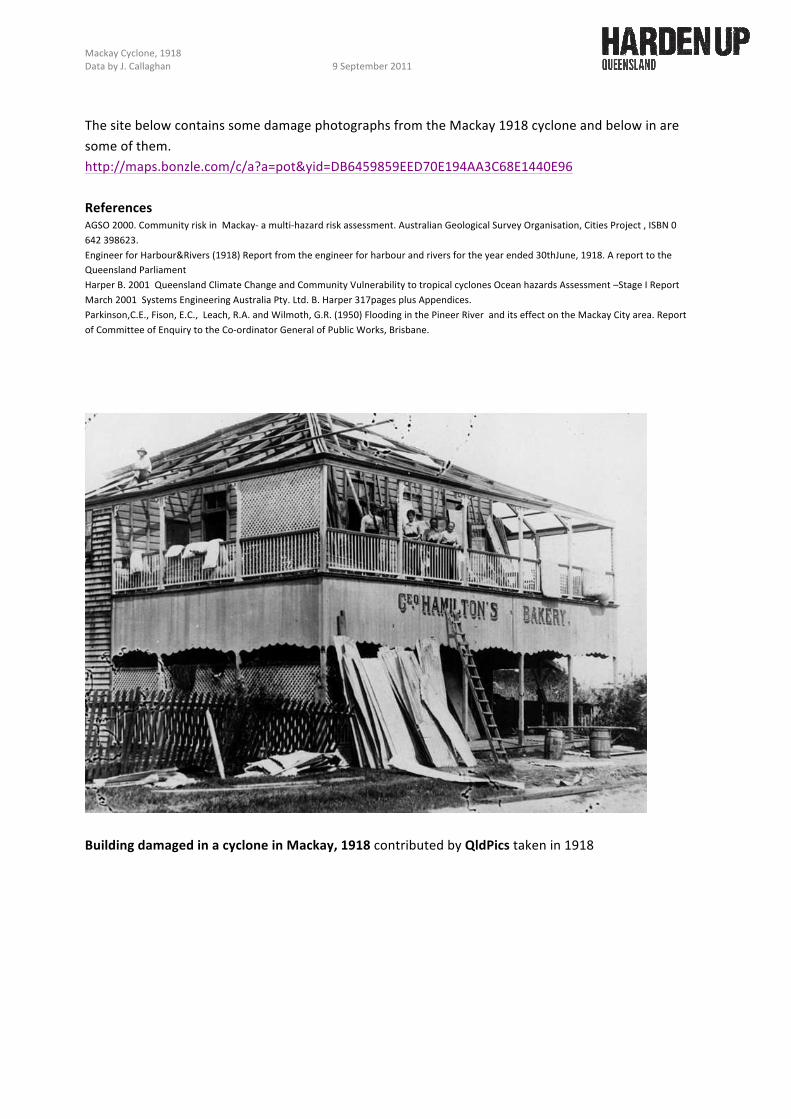
Building damaged in a cyclone in Mackay, 1918 contributed by QldPics taken in 1918
Mackay Cyclone, 1918 Data by J. Callaghan 9 September 2011
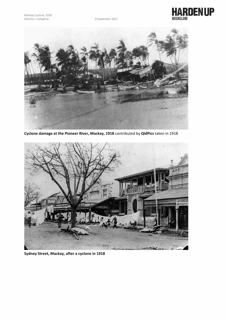
Cyclone damage at the Pioneer River, Mackay, 1918 contributed by QldPics taken in 1918
Sydney Street, Mackay, after a cyclone in 1918

Mackay Cyclone, 1918 Data by J. Callaghan 9 September 2011
Looking south down Sydney Street after a cyclone in Mackay in 1918. Many unroofed buildings and debris are visible in the street with trees having been stripped of their leaves. Clothing is hanging over the verandah railings to dry.
Cyclone damage to Croker's Wharf at Mackay , 1918 contributed by QldPics taken in 1918